

Remotely Sensed Fine-Fuel Changes from Wildfire and Prescribed Fire in a Semi-Arid Grassland


Abstract
:1. Introduction
2. Materials and Methods
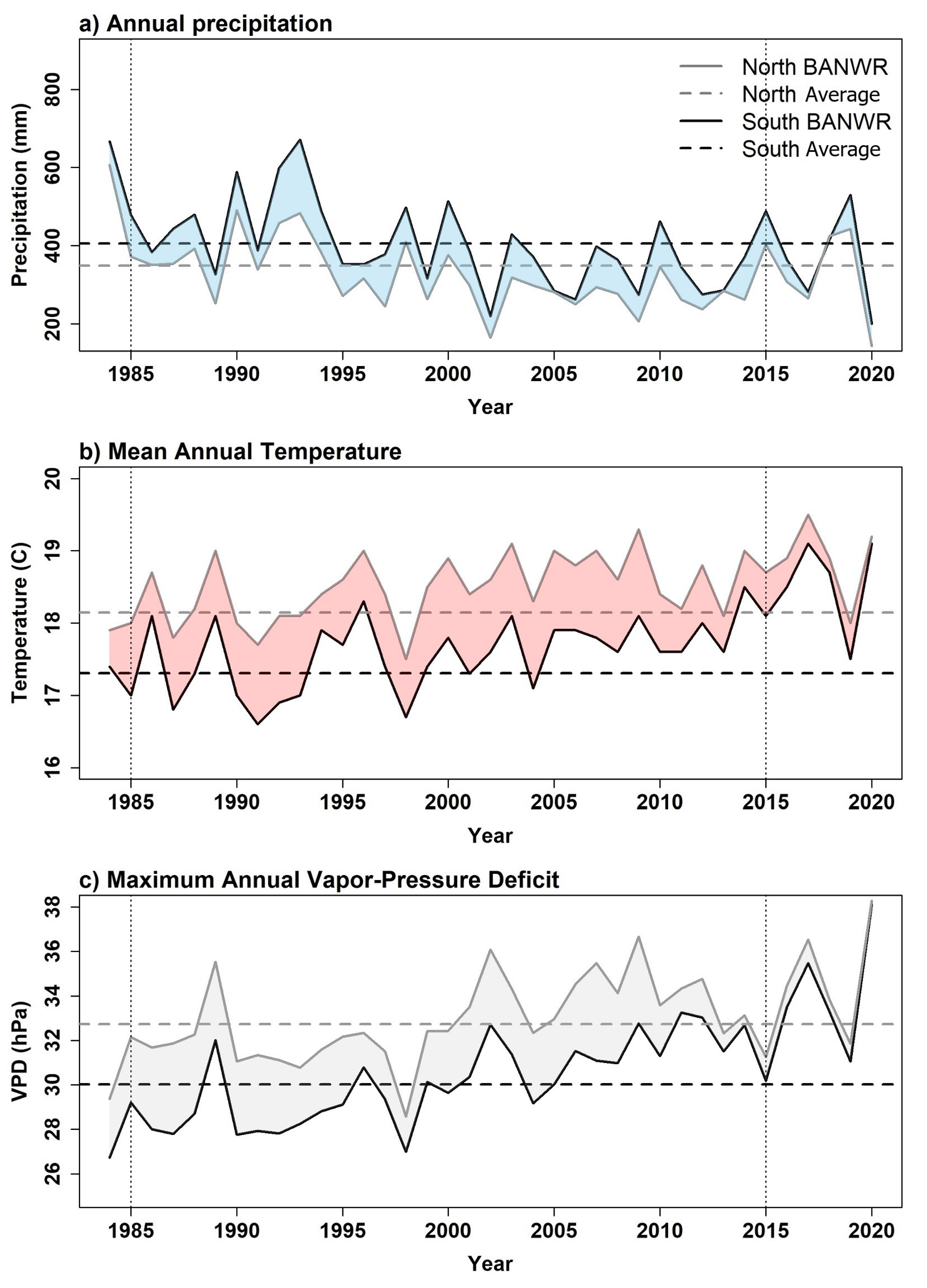
2.1. Study Area
2.2. Fire Data
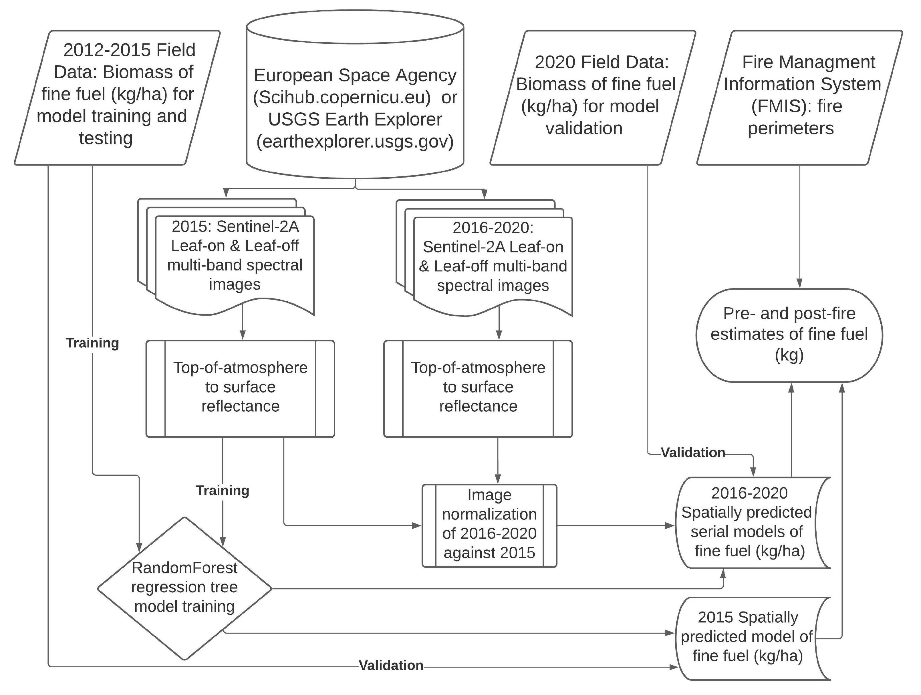
2.3. Remote Sensing Data
2.4. Modeling Fine-Fuels
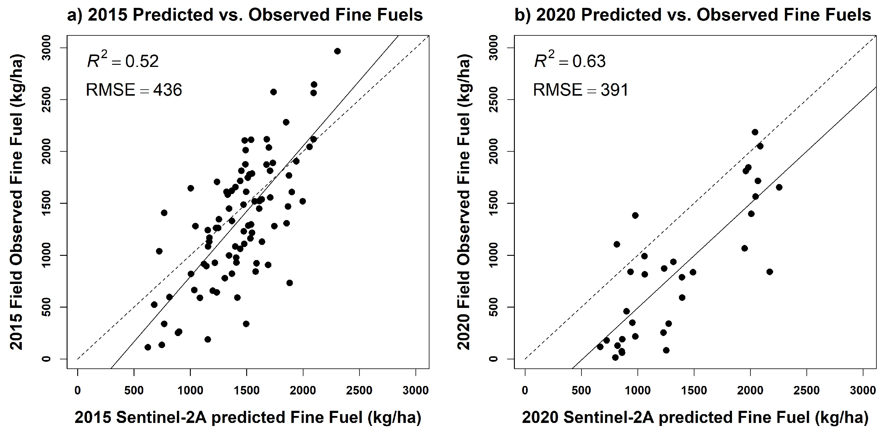
2.5. Model Validation
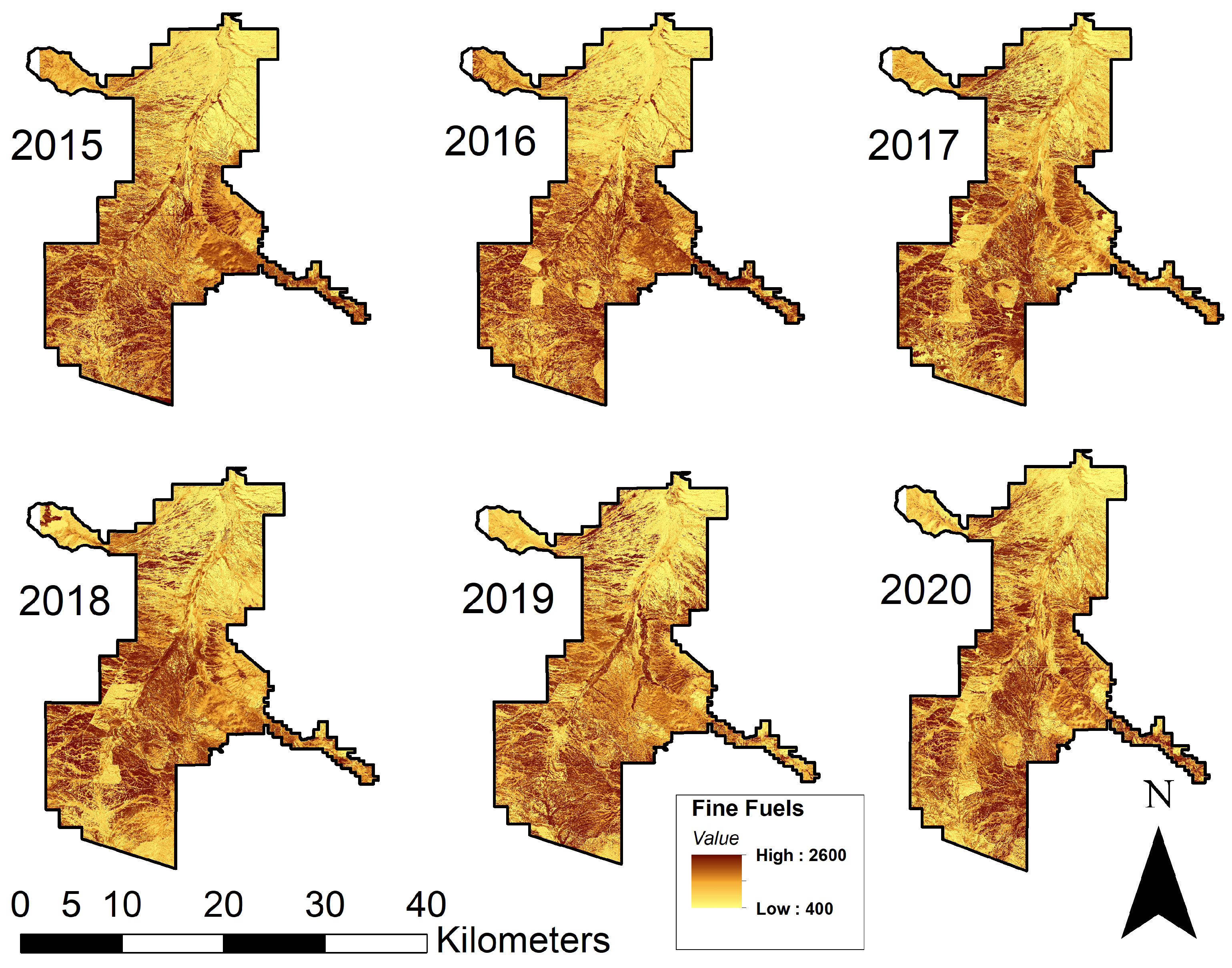
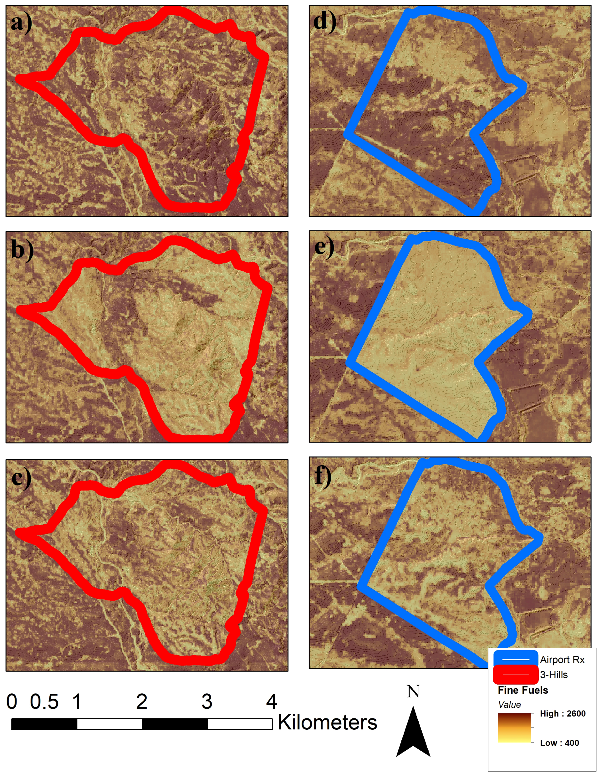
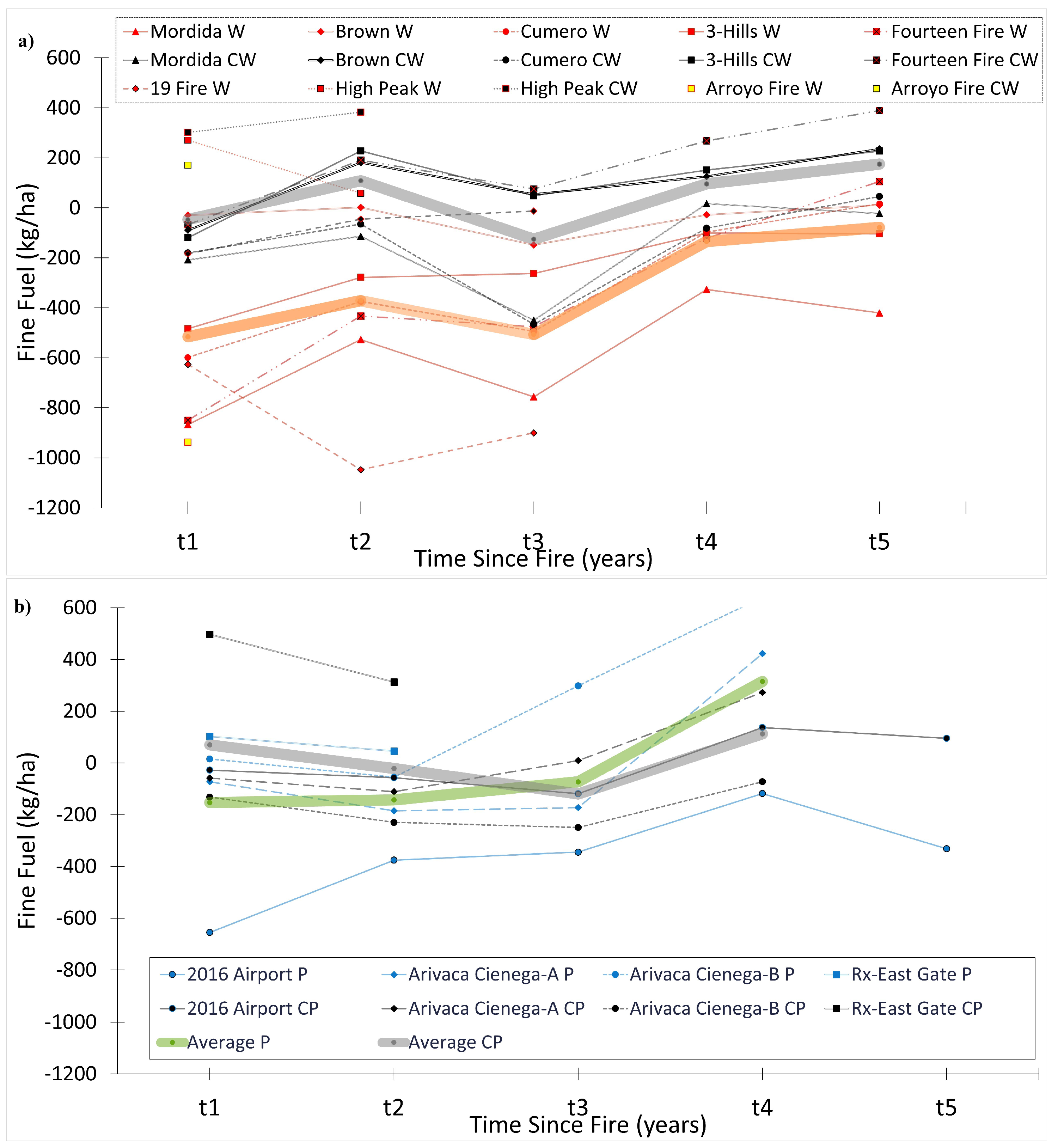
2.6. Fine-Fuel Changes
3. Results
4. Discussion
5. Conclusions
Author Contributions
Funding
Institutional Review Board Statement
Informed Consent Statement
Data Availability Statement
Acknowledgments
Conflicts of Interest
Abbreviations
| BANWR | Buenos Aires National Wildlife Refuge |
| caret | Classification and Regression Training |
| DEM | Digital Elevation Model |
| FMIS | Fire Management Information System |
| MODIS | Moderate Resolution Imaging Spectroradiometer |
| NDVI | Normalized Difference Vegetation Index |
| PRISM | Parameter-elevation Regressions on Independent Slopes Model |
| RMSE | Root Mean Square Error |
| SPOT | Satellite Pour l’Observation de la Terre |
| SRTM | Shuttle Radar Topography Mission |
Appendix A


| CASE: Fire Name | Type | Year | Date | 2015 | 2016 | 2017 | 2018 | 2019 | 2020 |
|---|---|---|---|---|---|---|---|---|---|
| 2016 Airport | P | 2016 | 06.07 | (1608) | 952 | 1232 | 1264 | 1490 | 1276 |
| Arivaca Cienega A | P | 2017 | 03.08 | 1662 | (1520) | 1448 | 1336 | 1348 | 1944 |
| Arivaca Cienega B | P | 2017 | 03.08 | 1554 | (1218) | 1232 | 1162 | 1516 | 1858 |
| RX-East Gate BP | P | 2019 | 03.05 | 1404 | 1312 | 1412 | (1248) | 1350 | 1294 |
| Fourteen Fire | W | 2015 | 08.22 | (1790) | 940 | 1356 | 1314 | 1668 | 1894 |
| Mordida | W | 2015 | 12.18 | (1758) | 892 | 1232 | 1002 | 1432 | 1338 |
| Brown | W | 2016 | 06.17 | (1284) | 1254 | 1286 | 1136 | 1256 | 1296 |
| Cumero | W | 2016 | 05.06 | (1672) | 1072 | 1296 | 1176 | 1574 | 1688 |
| Three Hills | W | 2016 | 07.21 | (1654) | 1172 | 1376 | 1392 | 1554 | 1550 |
| 19 Fire | W | 2018 | 08.07 | 1492 | 1338 | (1966) | 1338 | 918 | 1064 |
| High Peak | W | 2019 | 07.17 | 1458 | 1406 | 1182 | (1232) | 1504 | 1292 |
| Arroyo Fire | W | 2019 | 08.31 | 1642 | 1466 | 2104 | 1770 | (1914) | 978 |
| Average () | P | - | - | 1556 | 1250 | 1332 | 1252 | 1426 | 1592 |
| Average () | W | - | - | 1594 | 1192 | 1474 | 1296 | 1478 | 1388 |
| CONTROL | Type | Year | Date | 2015 | 2016 | 2017 | 2018 | 2019 | 2020 |
| 2016 Airport | CP | 2016 | NA | (1464) | 1436 | 1406 | 1346 | 1602 | 1560 |
| Arivaca Cienega A | CP | 2017 | NA | 1496 | (1464) | 1406 | 1354 | 1474 | 1738 |
| Arivaca Cienega B | CP | 2017 | NA | 1154 | (1262) | 1130 | 1032 | 1012 | 1190 |
| RX-East Gate BP | CP | 2019 | NA | 1376 | 1290 | 1426 | (1186) | 1682 | 1498 |
| Fourteen Fire | CW | 2015 | NA | (1398) | 1332 | 1590 | 1474 | 1666 | 1788 |
| Mordida | CW | 2015 | NA | (1578) | 1370 | 1462 | 1128 | 1596 | 1556 |
| Brown | CW | 2016 | NA | (1304) | 1214 | 1484 | 1356 | 1428 | 1538 |
| Cumero | CW | 2016 | NA | (1644) | 1462 | 1578 | 1176 | 1562 | 1688 |
| Three Hills | CW | 2016 | NA | (1544) | 1424 | 1772 | 1592 | 1694 | 1770 |
| 19 Fire | CW | 2018 | NA | 1226 | 1044 | (1510) | 1326 | 1464 | 1496 |
| High Peak | CW | 2019 | NA | 1580 | 1440 | 1388 | (1338) | 1640 | 1722 |
| Arroyo Fire | CW | 2019 | NA | 1378 | 1360 | 1682 | 1562 | (1636) | 1806 |
| Average () | CP | - | - | 1372 | 1364 | 1342 | 1230 | 1442 | 1496 |
| Average () | CW | - | - | 1456 | 1330 | 1558 | 1370 | 1586 | 1670 |
| CASE: Fire Name | Type | Year | Date | 2015 | 2016 | 2017 | 2018 | 2019 | 2020 |
|---|---|---|---|---|---|---|---|---|---|
| 2016 Airport | P | 2016 | 06.07 | (344) | 148 | 212 | 276 | 314 | 118 |
| Arivaca Cienega A | P | 2017 | 03.08 | 218 | (220) | 176 | 196 | 256 | 362 |
| Arivaca Cienega B | P | 2017 | 03.08 | 308 | (202) | 264 | 212 | 330 | 282 |
| RX-East Gate BP | P | 2019 | 03.05 | 352 | 302 | 378 | (288) | 362 | 270 |
| Fourteen Fire | W | 2015 | 08.22 | (248) | 170 | 144 | 106 | 78 | 386 |
| Mordida | W | 2015 | 12.18 | (456) | 140 | 210 | 108 | 308 | 252 |
| Brown | W | 2016 | 06.17 | (180) | 232 | 172 | 326 | 232 | 296 |
| Cumero | W | 2016 | 05.06 | (320) | 174 | 160 | 156 | 352 | 254 |
| Three Hills | W | 2016 | 07.21 | (396) | 268 | 306 | 280 | 292 | 246 |
| 19 Fire | W | 2018 | 08.07 | 226 | 230 | (304) | 166 | 218 | 320 |
| High Peak | W | 2019 | 07.17 | 104 | 156 | 104 | (90) | 110 | 198 |
| Arroyo Fire | W | 2019 | 08.31 | 444 | 210 | 372 | 248 | (204) | 234 |
| St. Dev. () | P | - | - | 306 | 218 | 258 | 242 | 314 | 258 |
| St. Dev. () | W | - | - | 298 | 198 | 222 | 184 | 224 | 274 |
| CONTROL | Type | Year | Date | 2015 | 2016 | 2017 | 2018 | 2019 | 2020 |
| 2016 Airport | CP | 2016 | NA | (280) | 260 | 368 | 318 | 298 | 248 |
| Arivaca Cienega A | CP | 2017 | NA | 282 | (294) | 278 | 294 | 338 | 374 |
| Arivaca Cienega B | CP | 2017 | NA | 266 | (346) | 250 | 244 | 254 | 336 |
| RX-East Gate BP | CP | 2019 | NA | 338 | 280 | 340 | (156) | 322 | 342 |
| Fourteen Fire | CW | 2015 | NA | (330) | 210 | 360 | 196 | 170 | 354 |
| Mordida | CW | 2015 | NA | (392) | 292 | 304 | 218 | 306 | 288 |
| Brown | CW | 2016 | NA | (252) | 270 | 342 | 246 | 326 | 320 |
| Cumero | CW | 2016 | NA | (326) | 236 | 304 | 178 | 328 | 320 |
| Three Hills | CW | 2016 | NA | (372) | 284 | 414 | 302 | 294 | 358 |
| 19 Fire | CW | 2018 | NA | 336 | 296 | (450) | 316 | 416 | 328 |
| High Peak | CW | 2019 | NA | 144 | 132 | 190 | (148) | 140 | 238 |
| Arroyo Fire | CW | 2019 | NA | 358 | 226 | 394 | 318 | (230) | 280 |
| St. Dev. () | CP | - | - | 292 | 296 | 310 | 278 | 304 | 324 |
| St. Dev. () | CW | - | - | 314 | 244 | 346 | 240 | 276 | 310 |
| CASE: Fire Name | Type | Year | Date | 2015 | 2016 | 2017 | 2018 | 2019 | 2020 |
|---|---|---|---|---|---|---|---|---|---|
| 2016 Airport | P | 2016 | 06.07 | - | −654 | −376 | −344 | −118 | −332 |
| Arivaca Cienega A | P | 2017 | 03.08 | - | - | −72 | −184 | −172 | 422 |
| Arivaca Cienega B | P | 2017 | 03.08 | - | - | 16 | −56 | 298 | 640 |
| RX-East Gate BP | P | 2019 | 03.05 | - | - | - | - | 102 | 46 |
| Fourteen Fire | W | 2015 | 08.22 | - | −850 | −434 | −476 | −122 | 104 |
| Mordida | W | 2015 | 12.18 | - | −866 | −528 | −756 | −326 | −420 |
| Brown | W | 2016 | 06.17 | - | −30 | 2 | −148 | −28 | 12 |
| Cumero | W | 2016 | 05.06 | - | −598 | −374 | −494 | −96 | 16 |
| Three Hills | W | 2016 | 07.21 | - | −484 | −278 | −262 | −102 | −104 |
| 19 Fire | W | 2018 | 08.07 | - | - | - | −626 | −1048 | −900 |
| High Peak | W | 2019 | 07.17 | - | - | - | - | 270 | 58 |
| Arroyo Fire | W | 2019 | 08.31 | - | - | - | - | - | −938 |
| Average Change () | P | - | - | - | −654 | −144 | −194 | 28 | 194 |
| Average Change () | W | - | - | - | −566 | −322 | −460 | −208 | −272 |
| CONTROL | Type | Year | Date | 2015 | 2016 | 2017 | 2018 | 2019 | 2020 |
| 2016 Airport | CP | 2016 | NA | - | −28 | −58 | −118 | 138 | 96 |
| Arivaca Cienega A | CP | 2017 | NA | - | - | −58 | −110 | 10 | 272 |
| Arivaca Cienega B | CP | 2017 | NA | - | - | −132 | −230 | −250 | −72 |
| RX-East Gate BP | CP | 2019 | NA | - | - | - | - | 496 | 314 |
| Fourteen Fire | CW | 2015 | NA | - | −68 | 190 | 76 | 268 | 390 |
| Mordida | CW | 2015 | NA | - | −208 | −114 | −450 | 16 | −22 |
| Brown | CW | 2016 | NA | - | −90 | 182 | 54 | 124 | 236 |
| Cumero | CW | 2016 | NA | - | −180 | −66 | −466 | −82 | 46 |
| Three Hills | CW | 2016 | NA | - | −120 | 228 | 48 | 152 | 226 |
| 19 Fire | CW | 2018 | NA | - | - | - | −184 | −46 | −14 |
| High Peak | CW | 2019 | NA | - | - | - | - | 302 | 384 |
| Arroyo Fire | CW | 2019 | NA | - | - | - | - | - | 170 |
| Average Change () | CP | - | - | - | −28 | −82 | −152 | 98 | 152 |
| Average Change () | CW | - | - | - | −132 | 84 | −154 | 106 | 176 |
| CASE: Event Name | Event | t | t | t | t | t |
|---|---|---|---|---|---|---|
| 2016 Airport | P | −654 | −376 | −344 | −118 | −332 |
| Arivaca Cienega A | P | −72 | −184 | −172 | 422 | - |
| Arivaca Cienega B | P | 16 | −56 | 298 | 640 | - |
| RX-East Gate BP | P | 102 | 46 | - | - | - |
| Fourteen Fire | W | −850 | −434 | −476 | −122 | 102 |
| Mordida | W | −866 | −528 | −765 | −326 | −420 |
| Brown | W | −30 | 2 | −148 | −28 | 12 |
| Cumero | W | −598 | −374 | −494 | −96 | 16 |
| Three Hills | W | −484 | −278 | −262 | −102 | −104 |
| 19 Fire | W | −626 | −1048 | −900 | - | - |
| High Peak | W | 270 | 58 | - | - | - |
| Arroyo Fire | W | −938 | - | - | - | - |
| Average | W & P | −394 | −288 | −294 | 54 | −120 |
| Average | W | −516 | −372 | −506 | −134 | −78 |
| Average | P | −152 | −142 | −72 | 316 | −332 |
| CONTROL | Event | t | t | t | t | t |
| 2016 Airport | CP | −28 | −58 | −118 | 138 | 96 |
| Arivaca Cienega A | CP | −58 | −110 | 10 | 272 | - |
| Arivaca Cienega B | CP | −132 | −230 | −250 | −72 | - |
| RX-East Gate BP | CP | 496 | 314 | - | - | - |
| Fourteen Fire | CW | −68 | 190 | 76 | 268 | 390 |
| Mordida | CW | −208 | −114 | −450 | 16 | −22 |
| Brown | CW | −90 | 182 | 54 | 124 | 236 |
| Cumero | CW | −180 | −66 | −466 | −82 | 46 |
| Three Hills | CW | −120 | 228 | 48 | 152 | 226 |
| 19 Fire | CW | −184 | −46 | −14 | - | - |
| High Peak | CW | 302 | 384 | - | - | - |
| Arroyo Fire | CW | 170 | - | - | - | - |
| Average | CW & CP | −8 | 62 | −138 | 96 | 162 |
| Average | CW | −48 | 108 | −126 | 96 | 174 |
| Average | CP | 70 | −22 | −120 | 112 | 96 |
References
- Westerling, A.L.; Hidalgo, H.G.; Cayan, D.R.; Swetnam, T.W. Warming and earlier spring increase western U.S. forest wildfire activity. Science 2006, 313, 940–943. [Google Scholar] [CrossRef] [PubMed]
- Abatzoglou, J.T.; Kolden, C.A. Climate change in western US deserts: Potential for increased wildfire and invasive annual grasses. Rangel. Ecol. Manag. 2011, 64, 471–478. [Google Scholar] [CrossRef]
- Schweizer, D.; Nichols, T.; Cisneros, R.; Navarro, K.; Procter, T. Wildland fire, extreme weather and society: Implications of a history of fire suppression in California, USA. In Extreme Weather Events and Human Health; Akhtar, R., Ed.; Springer Nature Switzerland: Cham, Switzerland, 2020; pp. 41–57. [Google Scholar]
- Smith, A.J.P.; Jones, M.W.; Abatzoglou, J.T.; Canadell, J.G.; Betts, R.A. ScienceBreif Review: Climate change increases the risk of wildfires, September 2020. In Critical Issues in Climate Change Science, Proceedings of the COP26 Climate Conference, Glasgow, Scotland, 31 October–12 November 2021; Le Quéré, C., Liss, P., Forster, P., Eds.; University of East Anglia: Norwich, UK, 2020. [Google Scholar]
- Zhang, X.; Kondragunta, S. Temporal and spatial variability in biomass burned areas across the USA derived from the GOES fire product. Remote Sens. Environ. 2008, 112, 2886–2897. [Google Scholar] [CrossRef]
- Twidwell, D.; Bielski, C.H.; Scholtz, R.; Fuhlendorf, S.D. Advancing fire ecology in 21st century rangelands. Rangel. Ecol. Manag. 2021, 78, 201–212. [Google Scholar] [CrossRef]
- D’Antonio, C.D.; Vitousek, P.M. Biological invasions by exotic grasses, the grass/fire cycle, and global change. Annu. Rev. Ecol. Sys. 1992, 23, 63–87. [Google Scholar] [CrossRef]
- White, M.R. Invasive Plants and Weeds of the National Forests and Grasslands in the Southwestern Region, 2nd ed.; MB-R3-16-6; U.S. Department of Agriculture Forest Service, Southwestern Region: Albuquerque, NM, USA, 2013; p. 245.
- Chambers, J.C.; Brooks, M.L.; Germino, M.J.; Maestas, D.I.B.; Jones, M.O.; Allred, B.W. Operationalizing resilience and resistance concepts to address invasive grass-fire cycles. Front. Ecol. Evol. 2019, 7, 1–25. [Google Scholar] [CrossRef]
- Davies, K.W.; Nafus, A.M. Exotic annual grass invasion alters fuel amounts, continuity and moisture content. Int. J. Wildl. Fire 2012, 22, 353–358. [Google Scholar] [CrossRef]
- Cable, D.R. Lehmann lovegrass on the Santa Rita Experimental Range, 1937–1968. J. Range Manag. 1971, 24, 17–21. [Google Scholar] [CrossRef]
- Fernandez, R.J.; Reynolds, J.F. Potential growth and drought tolerance of eight desert grasses: Lack of a trade-off? Oecologia 2000, 123, 90–98. [Google Scholar] [CrossRef] [PubMed]
- O’Dea, M.E. Influence of mycotrophy on native and introduced grass regeneration in a semi-arid grassland following burning. Rest. Ecol. 2007, 15, 149–155. [Google Scholar] [CrossRef]
- Archer, S.R.; Predick, K.I. Climate change and ecosystems of the southwestern United State. Rangelands 2008, 30, 23–28. [Google Scholar] [CrossRef]
- Wright, L.N.; Dobrenz, A.K. Efficiency of water use and associated characteristics of Lehmann lovegrass. J. Range Manag. 1973, 26, 210–212. [Google Scholar] [CrossRef]
- McClaran, M.P.; Van Devender, T.R. The Desert Grassland; University of Arizona Press: Tucson, AZ, USA, 1995; p. 346. [Google Scholar]
- Brooks, M.L.; D’Antonio, C.M.; Richardson, D.M.; Grace, J.B.; Keeley, J.E.; DiTomaso, J.M.; Hobbs, R.J.; Pellant, M.; Pyke, D. Effects of invasive alien plants on fire regimes. BioScience 2004, 54, 677–688. [Google Scholar] [CrossRef]
- Van Devender, T.R.; Felger, R.S.; Burquez, A.M. Exotic plants in the Sonoran desert region, Arizona and Sonora. In Proceedings of the 1997 Symposium Proceedings, California Exotic Pest Plant Council, Concord, CA, USA, 10–12 October 1997; pp. 1–6. [Google Scholar]
- Munson, S.M.; Sankey, T.T.; Xian, G.; Villarreal, M.L.; Homer, C.G. Decadal shifts in grass and woody plant cover are driven by prolonged drying and modified by topo-edaphic properties. Ecol. Appl. 2016, 26, 2480–2494. [Google Scholar] [CrossRef] [PubMed]
- Doerr, S.H.; Santín, C. Global trends in wildfire and its impacts: Perceptions versus realities in a changing world. Phil. Trans. R. Soc. B Biol. Sci. 2016, 371, 20150345. [Google Scholar] [CrossRef]
- Kolden, C.A. We’re not doing enough prescribed fire in the Western United States to mitigate wildfire risk. Fire 2019, 2, 30. [Google Scholar] [CrossRef]
- Laushman, K.M.; Munson, S.M.; Villarreal, M.L. Wildfire risk and hazardous fuel reduction treatments along the US-Mexico border; a review of the science (1986–2019). Air Soil Water Res. 2020, 13, 1–7. [Google Scholar] [CrossRef]
- Petrakis, R.E.; Villarreal, M.L.; Wu, Z.; Hetzler, R.; Middleton, B.R.; Norman, L.M. Evaluating and monitoring forest fuel treatments using remote sensing applications in Arizona, USA. For. Ecol. Manag. 2018, 413, 48–61. [Google Scholar] [CrossRef]
- Villarreal, M.L.; Haire, S.L.; Iniguez, J.M.; Montaño, C.C.; Poitras, T.B. Distant neighbors: Recent wildfire patterns of the Madrean Sky Islands of southwestern United States and northwestern Mexico. Fire Ecol. 2019, 15, 2. [Google Scholar] [CrossRef]
- Sesnie, S.; Dickson, B.G. Final Report. In Determining Prescribed Fire and Fuel Treatment Compatibility with Semi-Desert Grassland Habitat Rehabilitation for the Critically Endangered Masked Bobwhite Quail (Colinus Virginianus Ridgwayi); JFSP Project ID 13-1-06-16; Joint Fire Science Program: Boise, ID, USA, 2018; p. 93. [Google Scholar]
- Sayre, N.F. A history of working landscapes: The Alter Valley, Arizona, USA. Rangelands 2007, 29, 41–45. [Google Scholar] [CrossRef]
- Hernández, F.; Kuvlesky, W.P., Jr.; DeYoung, R.W.; Brennan, L.A.; Gall, S.A. Recovery of rare species: Case study of the masked bobwhite. J. Wildl. Manag. 2006, 70, 617–631. [Google Scholar] [CrossRef]
- Sayre, N.F. Ranching, Endangered Species, and Urbanization in the Southwest; Species of Capital; University of Arizona Press: Tucson, AZ, USA, 2002; p. 278. [Google Scholar]
- Hill, M.J. Vegetation index suites as indicators of vegetation state in grassland and savanna: An analysis with simulated SENTINEL 2 data for a North American transect. Remote Sens. Environ. 2013, 137, 94–111. [Google Scholar] [CrossRef]
- Ali, I.; Cawkwell, F.; Dwyer, E.; Barrett, B.; Green, S. Satellite remote sensing of grasslands: From observation to management. J. Plant Ecol. 2016, 9, 649–671. [Google Scholar] [CrossRef]
- Marsett, R.C.; Qi, J.; Heilman, P.; Biedenbender, S.H.; Watson, M.C.; Amer, S.; Weltz, M.; Goodrich, D.; Marrsett, R. Remote sensing for grassland management in the arid southwest. Rangel. Ecol. Manag. 2006, 59, 530–540. [Google Scholar] [CrossRef]
- Drusch, M.; Del Bello, U.; Carlier, S.; Colin, O.; Fernandez, V.; Gascon, F.; Hoersch, B.; Isola, C.; Laberinti, P.; Martimort, P.; et al. Sentinel-2: ESA’s Optical High-Resolution Mission for GMES Operational Services. Remote Sens. Environ. 2012, 120, 25–36. [Google Scholar] [CrossRef]
- Fassnacht, F.E.; Poblee-Olivares, J.; Rivero, L.; Lopatin, J.; Ceballos-Comisso, A.; Galleguillos, M. Using Sentinel-2 and canopy height models to derive a landscape-level biomass map covering multiple vegetation types. Int. J. Appl. Earth Obs. Geoinf. 2021, 94, 102236. [Google Scholar] [CrossRef]
- Ruhlman, J.; Gass, L.; Middleton, B. Chapter 28, Madrean Archipelago Ecoregion. In Status and Trends of Land Change in the Western United States-1973 to 2000; Sleeter, B.M., Wilson, T.S., Acevedo, W., Eds.; U.S. Geological Survey Professional Paper 1794-A; 2012; p. 324. Available online: https://pubs.usgs.gov/pp/1794/a/ (accessed on 20 June 2020).
- Cable, D.R.; Martin, S.C. Invasion of semidesert grassland by velvet mesquite and associated vegetation changes. J. Ariz. Acad. Sci. 1973, 8, 127–134. [Google Scholar] [CrossRef]
- CSAP: Climate Science Applications Program. 2021. Available online: https://cals.arizona.edu/climate/index.htm (accessed on 21 June 2021).
- Daly, C.; Halbleib, M.; Smith, J.I.; Gibson, W.P.; Doggett, M.K.; Taylor, G.H.; Curtis, J.; Pasteris, P. Physiographically sensitive mapping of climatological temperature and precipitation across the conterminous United States. Int. J. Climatol. 2008, 28, 2031–2064. [Google Scholar] [CrossRef]
- Clevers, J.G.O.; Gitelson, A.A. Using the red-edge bands on Sentinel-2 for retrieving canopy chlorophyll and nitrogen content. In Proceedings of the 1st Sentinel-2 Preparatory Symposium ((European Space Agency, (Special Publication) ESA SP), Frascati, Italy, 23–27 April 2012; Volume 707 SP. [Google Scholar]
- Pérez-Cabello, F.; Montorio, R.; Alves, D.B. Remote Sensing Techniques to assess Post-Fire Vegetation Recovery. Curr. Opin. Envi. Sci. Health 2012, 100251. [Google Scholar] [CrossRef]
- Main-Knorn, M.; Pflug, B.; Louis, J.; Debaecker, V.; Müller-Wilm, U.; Gascon, F. Sen2Cor for Sentinel-2. Conference Proceeding: Image and Signal Processing for Remote Sensing. 2018. Available online: http://step.esa.int/main/third-party-plugins-2/sen2cor/ (accessed on 11 August 2020).
- Canty, M. Image Analysis, Classification and Change Detection in Remote Sensing, with Algorithms for Python, 4th ed.; CRC Press Taylor & Francis Group: Boca Raton, FL, USA, 2019; p. 532. Available online: https://mortcanty.github.io/src/software.html (accessed on 10 July 2020).
- Sesnie, S.; Eagleston, H.; Johnson, L.; Yurcich, E. In-situ and remote sensing platforms for mapping fine-fuels and fuel-types in Sonoran semi-desert grasslands. Remote Sens. 2018, 10, 1358. [Google Scholar] [CrossRef]
- R Core Team. R: A Language and Environment for Statistical Computing; R Foundation for Statistical Computing: Vienna, Austria, 2019; Available online: https://www.R-project.org/ (accessed on 10 November 2020).
- Kuhn, M. Building predictive models in R using the caret package. J. Stat. Softw. 2008, 28, 1–26. [Google Scholar] [CrossRef]
- Farr, T.G.; Rosen, P.A.; Caro, E.; Crippen, R.; Duren, R.; Hensley, S.; Kobrick, M.; Paller, M.; Rodriguez, E.; Roth, L.; et al. The shuttle radar topography mission. Rev. Geophys. 2007, 45, RG2004. [Google Scholar] [CrossRef]
- Gray, M.E.; Dickson, B.G.; Zachmann, L.J. Modelling and mapping dynamic variability in large fire probability in the lower Sonoran Desert of south-western Arizona. Int. J. Wildl. Fire 2014, 23, 1108–1118. [Google Scholar] [CrossRef]
- Li, Z.; Shi, H.; Vogelmann, J.E.; Hawbaker, T.J.; Peterson, B. Assessment of fire fuel load dynamics in shrubland ecosystems in the western United States using MODIS products. Remote Sens. 2020, 12, 1911. [Google Scholar] [CrossRef]
- Hillman, S.; Hally, B.; Wallace, L.; Turner, D.; Lucieer, A.; Reinke, K.; Jones, S. High-resolution estimates of fire severity—An evaluation of UAS image and LiDAR mapping approaches on a sedgeland forest boundary in Tasmania, Australia. Fire 2021, 4, 14. [Google Scholar] [CrossRef]
- Eames, T.; Russell-Smith, J.; Yates, C.; Edwards, A.; Vernooij, R.; Ribeiro, N.; Steinbruch, F.; van der Werf, G.R. Instantaneous pre-fire biomass and fuel load measurements from multi-spectral UAS mapping in southern African Savannas. Fire 2021, 4, 2. [Google Scholar] [CrossRef]
- Augustine, D.J.; Derner, J.D.; Smith, D.P. Characteristics of burns conducted under modified prescriptions to mitigate limited fuels in a semi-arid grassland. Fire Ecol. 2014, 10, 36–47. [Google Scholar] [CrossRef]
- Guerschman, J.P.; Hill, M.J.; Renzullo, L.J.; Barrett, D.J.; Marks, A.S.; Botha, E.J. Estimating fractional cover of photosynthetic vegetation, non-photosynthetic vegetation and bare soil in the Australian tropical savanna region upscaling the EO-1 Hyperion and MODIS sensors. Remote Sens. Environ. 2009, 113, 928–945. [Google Scholar] [CrossRef]
- Villarreal, M.L.; Norman, L.M.; Buckley, S.; Wallace, C.S.A.; Coe, M.A. Multi-index time series monitoring of drought and fire effects on desert grasslands. Remote Sens. Environ. 2016, 183, 186–197. [Google Scholar] [CrossRef]
- Elkind, K.; Sankey, T.T.; Munson, S.M.; Aslan, C.E. Invasive buffelgrass detection using high-resolution satellite and UAV imagery on Google Earth Engine. Remote Sens. Ecol. Conserv. 2019, 5, 318–331. [Google Scholar] [CrossRef]
- Bishop, T.B.; Munson, S.; Gill, R.A.; Belnap, J.; Petersen, S.L.; Clair, S.B.S. Spatiotemporal patterns of cheatgrass invasion in Colorado Plateau National Parks. Lands Ecol. 2019, 34, 925–941. [Google Scholar] [CrossRef]
- Seager, R.; Vecchi, G.A. Greenhouse warming and the 21st century hydroclimate of southwestern North America. Proc. Natl. Acad. Sci. USA 2010, 107, 21277–21282. [Google Scholar] [CrossRef]
- Pascale, S.; Boos, W.R.; Bordoni, S.; Delworth, T.L.; Kapnick, S.B.; Murakami, H.; Vecchi, G.A.; Zhang, W. Weakening of the North American monsoon with global warming. Nat. Clim. Chang. 2017, 7, 806–812. [Google Scholar] [CrossRef]
- McDonald, C.J.; McPherson, G.R. Creating hotter fires in the Sonoran Desert: Buffelgrass produces copious fuels and high fire temperatures. Fire Ecol. 2013, 9, 26–39. [Google Scholar] [CrossRef]
- Cox, J.R.; Ruyle, G.B. Influence of climatic and edaphic factors on the distribution of Eragrostis lehmanniana Nees in Arizona, USA. J. Grassl. Soc. S. Afr. 1986, 3, 25–29. [Google Scholar] [CrossRef]
- Cox, J.R. Lehmann lovegrass live component biomass and chemical composition. J. Range Manag. 1992, 45, 523–527. [Google Scholar] [CrossRef]
- Ruyle, G.B.; Roundy, B.A.; Cox, J.R. Effects of burning on germinability of Lehmann lovegrass. J. Range Manag. 1988, 41, 404–406. [Google Scholar] [CrossRef]
- Geiger, E.L.; McPherson, G.R. Response of semi-desert grasslands invaded by non-native grasses to altered disturbance regimes. J. Biogeogr. 2005, 32, 895–902. [Google Scholar] [CrossRef]
- Frasier, G.W.; Cox, J.R. Water balance in pure stand of Lehmann lovegrass. J. Range Manag. 2000, 47, 373–378. [Google Scholar] [CrossRef]
- Levi, M.R.; Bestelmeyer, B.T. Biophysical influences on the spatial distribution of fire in the desert grassland region of the southwestern USA. Landsc. Ecol. 2016, 31, 2079–2095. [Google Scholar] [CrossRef]
- Brooks, M.; Lusk, M. Fire Management and Invasive Plants: A Handbook; United States Fish and Wildlife Service: Arlington, VA, USA, 2008; p. 27.
- Knapp, E.E.; Estes, B.L.; Skinner, C.N. Ecological Effects of Prescribed Fire Season: A Literature Review and Synthesis for Managers; Gen. Tech. Rep. PSW-GTR-224; US Department of Agriculture, Forest Service, Pacific Southwest: Albany, CA, USA, 2009; p. 81.
- Cable, D.R. Fire effects on semi-desert grasses and shrubs. J. Range Manag. 1967, 20, 326–329. [Google Scholar] [CrossRef]
- Wright, H.A.; Bailey, A.W. Fire Ecology: United States and Southern Canada, 2nd ed.; John Wiley & Sons: Hoboken, NJ, USA, 1982; p. 528. [Google Scholar]
- Bradford, J.B.; Betancourt, J.L.; Butterfield, B.J.; Munson, S.M.; Wood, T.E. Anticipatory natural resource science and management for a changing future. Front. Ecol. Environ. 2018, 16, 295–303. [Google Scholar] [CrossRef]
- Linn, R.R.; Goodrick, S.L.; Brambilla, S.; Brown, M.J.; Middleton, R.S.; O’Brien, J.J.; Hiers, J.K. QUIC-fire: A fast-running simulation tool for prescribed fire planning. Environ. Model. Softw. 2020, 125, 104616. [Google Scholar] [CrossRef]
- Wells, A.G.; Munson, S.M. Remotely Sensed Fine-Fuel Data for Buenos Aires National Wildlife Refuge (BANWR) from 2015 to 2020: U.S. Geological Survey Data Realease. 2021. Available online: https://www.sciencebase.gov/catalog/ (accessed on 11 September 2021).


| Spectral Band | Importance |
|---|---|
| b11.off | 100.0 |
| b5.on | 73.2 |
| b4.on | 72.6 |
| b8.on | 61.8 |
| b6.on | 60.5 |
| b2.on | 51.7 |
| b12.on | 51.2 |
| b11.on | 47.7 |
| b12.off | 45.3 |
| b3.on | 42.4 |
| b4.off | 39.3 |
| b7.on | 35.5 |
| b2.off | 34.1 |
| b9.on | 33.0 |
| b8a.on | 25.7 |
| b1.off | 17.4 |
| b1.on | 16.4 |
| b3.off | 12.7 |
| b8.off | 8.6 |
| b9.off | 6.6 |
Publisher’s Note: MDPI stays neutral with regard to jurisdictional claims in published maps and institutional affiliations. |
© 2021 by the authors. Licensee MDPI, Basel, Switzerland. This article is an open access article distributed under the terms and conditions of the Creative Commons Attribution (CC BY) license (https://creativecommons.org/licenses/by/4.0/).
Share and Cite
Wells, A.G.; Munson, S.M.; Sesnie, S.E.; Villarreal, M.L. Remotely Sensed Fine-Fuel Changes from Wildfire and Prescribed Fire in a Semi-Arid Grassland. Fire 2021, 4, 84. https://doi.org/10.3390/fire4040084
Wells AG, Munson SM, Sesnie SE, Villarreal ML. Remotely Sensed Fine-Fuel Changes from Wildfire and Prescribed Fire in a Semi-Arid Grassland. Fire. 2021; 4(4):84. https://doi.org/10.3390/fire4040084
Chicago/Turabian StyleWells, Adam G., Seth M. Munson, Steven E. Sesnie, and Miguel L. Villarreal. 2021. "Remotely Sensed Fine-Fuel Changes from Wildfire and Prescribed Fire in a Semi-Arid Grassland" Fire 4, no. 4: 84. https://doi.org/10.3390/fire4040084
APA StyleWells, A. G., Munson, S. M., Sesnie, S. E., & Villarreal, M. L. (2021). Remotely Sensed Fine-Fuel Changes from Wildfire and Prescribed Fire in a Semi-Arid Grassland. Fire, 4(4), 84. https://doi.org/10.3390/fire4040084