
Vegetation Recovery Patterns in Burned Areas Assessed with Landsat 8 OLI Imagery and Environmental Biophysical Data


Abstract
:1. Introduction
2. Materials and Methods
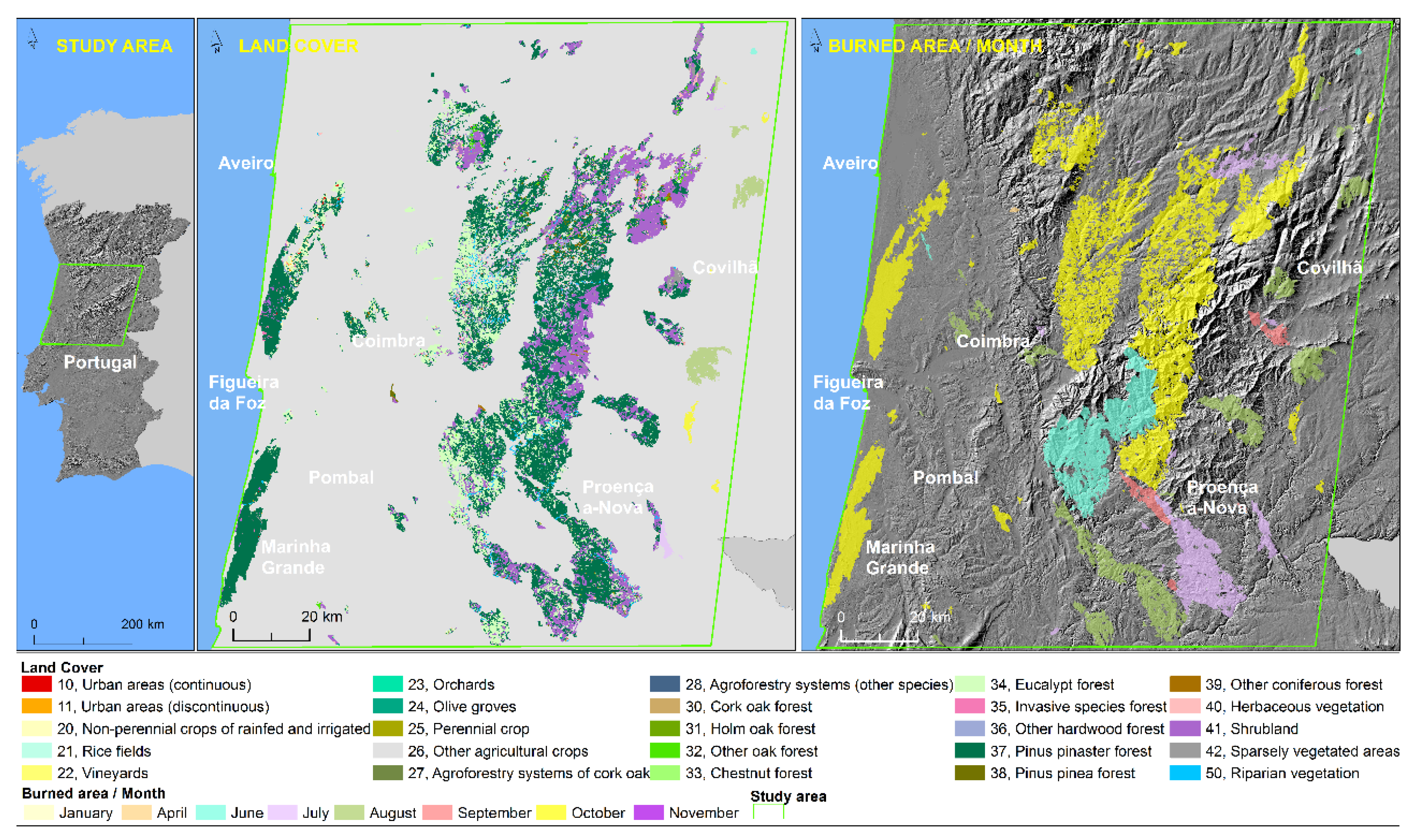
2.1. Study Area
2.2. Data
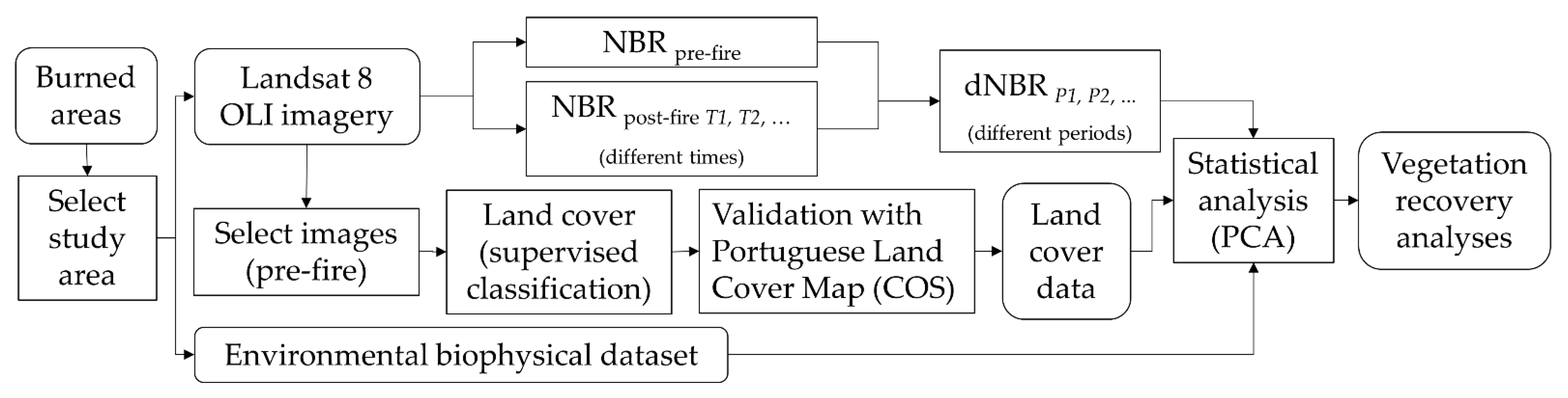
2.3. Methods
3. Results
3.1. Burned Area Distribution by LUC
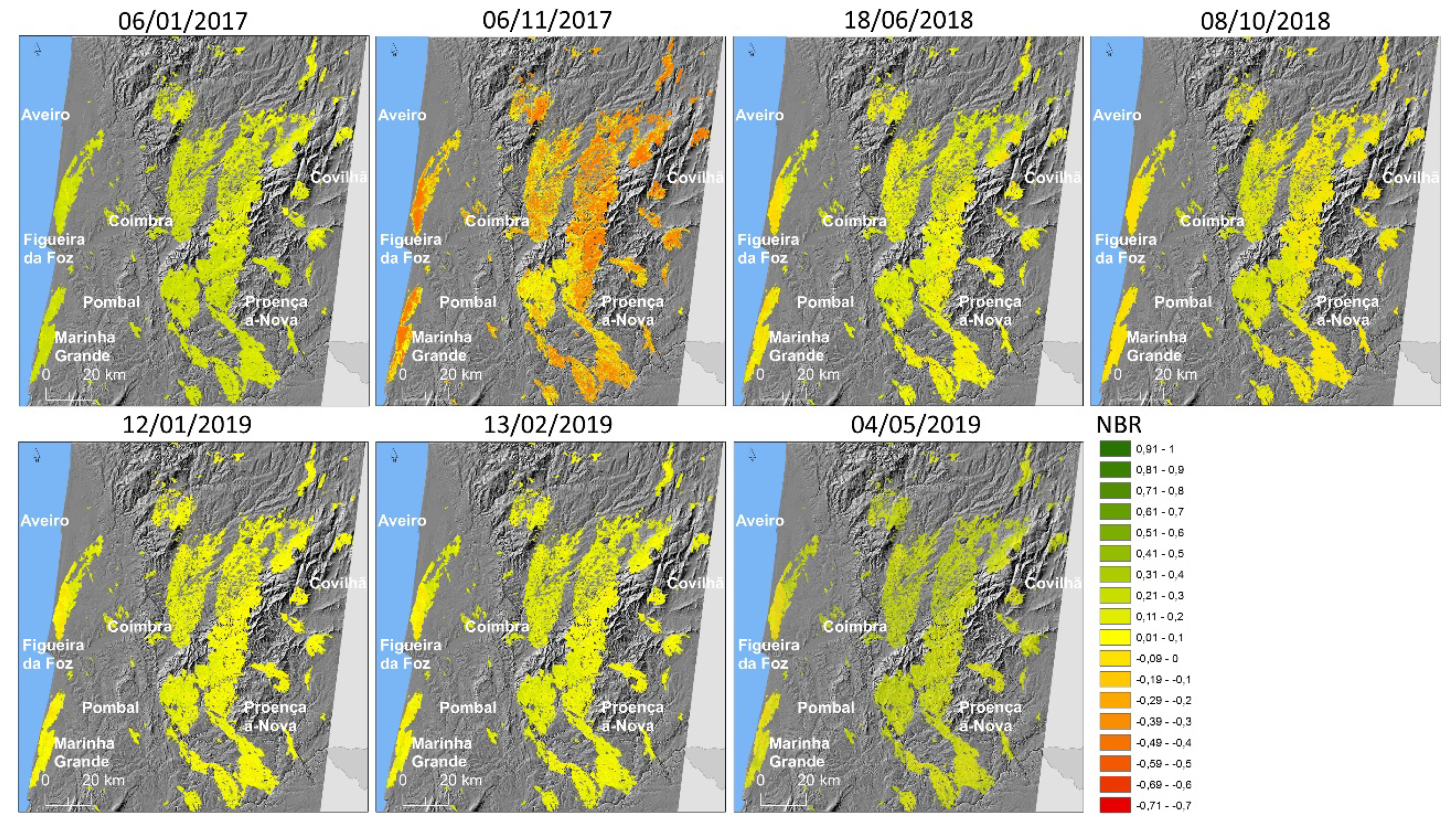
3.2. Burned Ratio Index
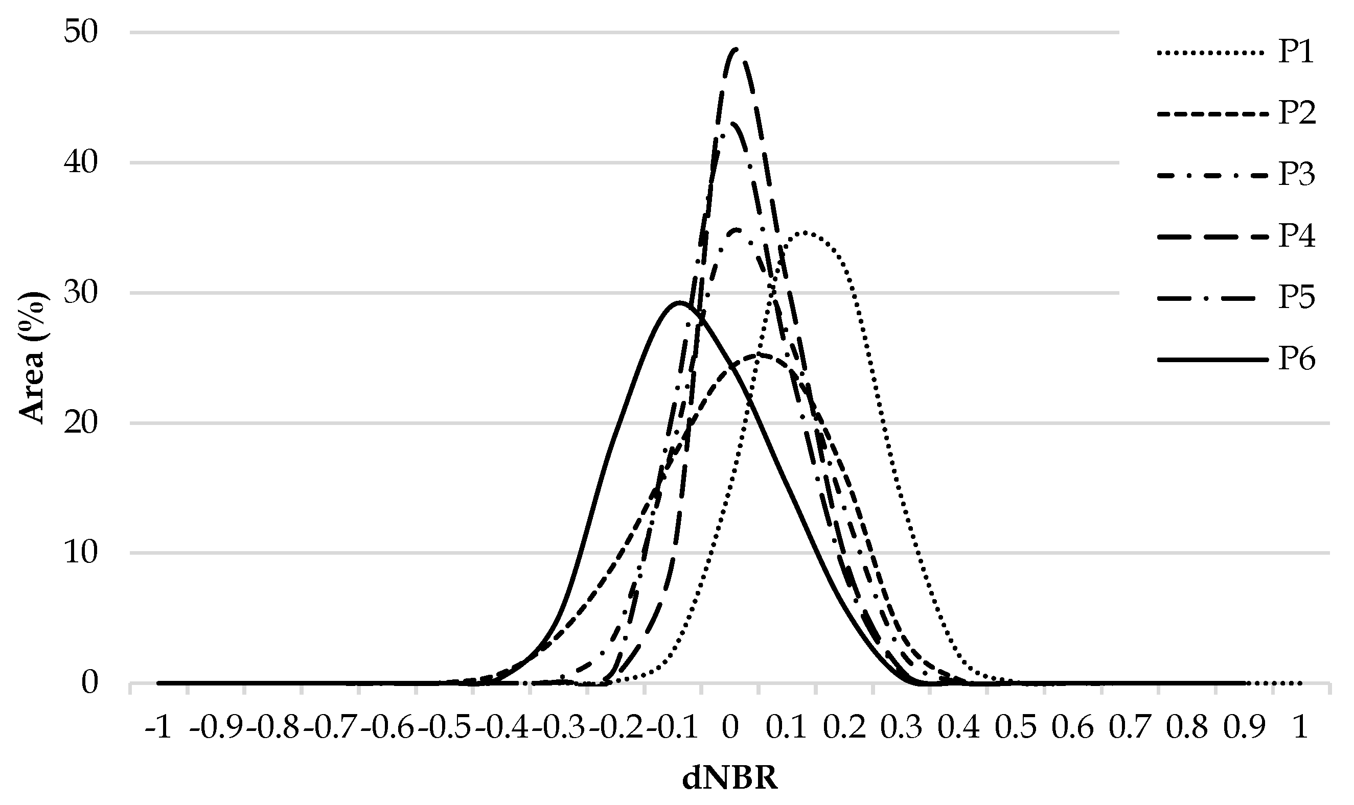
3.3. Differenced Burned Ratio Index
3.4. The Importance of Biophysical Factors on Vegetation Recovery of Burned Areas
4. Discussion
5. Conclusions
Author Contributions
Funding
Informed Consent Statement
Data Availability Statement
Acknowledgments
Conflicts of Interest
References
- Doerr, S.H.; Santin, C. Global trends in wildfire and its impacts: Perceptions versus realities in a changing world. Philos. Trans. R. Soc. B Biol. Sci. 2016, 371, 20150345. [Google Scholar] [CrossRef]
- Seidl, R.; Donato, D.C.; Raffa, K.F.; Turner, M.G. Spatial variability in tree regeneration after wildfire delays and dampens future bark beetle outbreaks. Proc. Natl. Acad. Sci. USA 2016, 113, 13075–13080. [Google Scholar] [CrossRef] [Green Version]
- Nyman, P.; Smith, H.G.; Sherwin, C.B.; Langhans, C.; Lane, P.N.J.; Sheridan, G.J. Predicting sediment delivery from debris flows after wildfire. Geomorphology 2015, 250, 173–186. [Google Scholar] [CrossRef]
- Stevens-Rumann, C.S.; Kemp, K.B.; Higuera, P.E.; Harvey, B.J.; Rother, M.T.; Donato, D.C.; Morgan, P.; Veblen, T.T. Evidence for declining forest resilience to wildfires under climate change. Ecol. Lett. 2018, 21, 243–252. [Google Scholar] [CrossRef] [PubMed]
- Finlay, S.E.; Moffat, A.; Gazzard, R.; Baker, D.; Murray, V. Health impacts of wildfires. PLoS Curr. 2012, 4, e4f959951cce2c. [Google Scholar] [CrossRef] [PubMed]
- Rego, F.M.C.C.; Rodríguez, J.M.M.; Calzada, V.R.V.; Xanthopoulos, G. Forest Fires—Sparking Firesmart Policies in the EU; Faivre, N., Ed.; European Commission: Brussels, Belgium, 2018. [Google Scholar]
- Oliveira, S.; Félix, F.; Nunes, A.; Lourenço, L.; Laneve, G.; Sebastián-López, A. Mapping wildfire vulnerability in Mediterranean Europe. Testing a stepwise approach for operational purposes. J. Environ. Manag. 2018, 206, 158–169. [Google Scholar] [CrossRef] [PubMed]
- Calviño-Cancela, M.; Chas-Amil, M.L.; García-Martínez, E.D.; Touza, J. Wildfire risk associated with different vegetation types within and outside wildland-urban interfaces. For. Ecol. Manag. 2016, 372, 1–9. [Google Scholar] [CrossRef] [Green Version]
- O’Donnell, A.J.; Boer, M.M.; McCaw, W.L.; Grierson, P.F. Vegetation and landscape connectivity control wildfire intervals in unmanaged semi-arid shrublands and woodlands in Australia. J. Biogeogr. 2011, 38, 112–124. [Google Scholar] [CrossRef]
- Fernandes, P.M.; Fernandes, M.M.; Loureiro, C. Post-fire live residuals of maritime pine plantations in Portugal: Structure, burn severity, and fire recurrence. For. Ecol. Manag. 2015, 347, 170–179. [Google Scholar] [CrossRef]
- Pereira, P.; Ubeda, X.; Martin, D.; Mataix-Solera, J.; Guerrero, C. Effects of a low severity prescribed fire on water-soluble elements in ash from a cork oak (Quercus suber) forest located in the northeast of the Iberian Peninsula. Environ. Res. 2011, 111, 237–247. [Google Scholar] [CrossRef]
- Shakesby, R.; Doerr, S. Wildfire as a hydrological and geomorphological agent. Earth-Sci. Rev. 2006, 74, 269–307. [Google Scholar] [CrossRef]
- Soulis, K.; Valiantzas, J.; Dercas, N. Modelling forest fires hydrological impact using spatio-temporal geographical data. In Proceedings of the 2010 International Congress on Environmental Modelling and Software, Ottawa, ON, Canada, 5–8 July 2010. [Google Scholar]
- Meneses, B.M.; Reis, E.; Reis, R.; Vale, M.J. Post-wildfires effects on physicochemical properties of surface water: The case study of Zêzere watershed (Portugal). Ribagua 2019, 6, 34–48. [Google Scholar] [CrossRef] [Green Version]
- Bastos, A.; Gouveia, C.M.; Dacamara, C.C.; Trigo, R.M. Modelling post-fire vegetation recovery in Portugal. Biogeosciences 2011, 8, 3593–3607. [Google Scholar] [CrossRef] [Green Version]
- Rodrigues, M.; Ibarra, P.; Echeverría, M.; Pérez-Cabello, F.; Riva, J.D.L. A method for regional-scale assessment of vegetation recovery time after high-severity wildfires: Case study of Spain. Prog. Phys. Geogr. 2014, 38, 556–575. [Google Scholar] [CrossRef]
- Viana-Soto, A.; Aguado, I.; Martínez, S. Assessment of post-fire vegetation recovery using fire severity and geographical data in the mediterranean region (Spain). Environments 2017, 4, 90. [Google Scholar] [CrossRef] [Green Version]
- Moya, D.; Sagra, J.; Lucas-Borja, M.E.; Plaza-álvarez, P.A.; González-Romero, J.; De Las Heras, J.; Ferrandis, P. Post-fire recovery of vegetation and diversity patterns in semiarid pinus halepensis mill. Habitats after salvage logging. Forests 2020, 11, 1345. [Google Scholar] [CrossRef]
- Bright, B.C.; Hudak, A.T.; Kennedy, R.E.; Braaten, J.D.; Henareh Khalyani, A. Examining post-fire vegetation recovery with Landsat time series analysis in three western North American forest types. Fire Ecol. 2019, 15, 8. [Google Scholar] [CrossRef] [Green Version]
- Calvo, L.; Santalla, S.; Valbuena, L.; Marcos, E.; Tárrega, R.; Luis-Calabuig, E. Post-fire natural regeneration of a Pinus pinaster forest in NW Spain. Plant Ecol. 2008, 197, 81–90. [Google Scholar] [CrossRef]
- Pereira, J.S.; Pereira, J.M.C.; Rego, F.C.; Silva, J.M.N.; Silva, T.P. (Eds.) Incêndios Florestais em Portugal: Caracterização, Impactes e Prevençã, 1st ed.; Instituto Superior de Agronomia: Lisbon, Portugal, 2006. [Google Scholar]
- Hanley, M.E.; Fenner, M. Pre-germination temperature and the survivorship and onward growth of Mediterranean fire-following plant species. Acta Oecol. 1998, 19, 181–187. [Google Scholar] [CrossRef]
- Thanos, C.A.; Rundel, P.W. Fire-followers in chaparral: Nitrogenous compounds trigger seed germination. J. Ecol. 1995, 83, 207. [Google Scholar] [CrossRef]
- Meneses, B.M.; Reis, E.; Reis, R. Assessment of the recurrence interval of wildfires in mainland Portugal and the identification of affected LUC patterns. J. Maps 2018, 14, 282–292. [Google Scholar] [CrossRef]
- Maia, P.; Pausas, J.G.; Vasques, A.; Keizer, J.J. Fire severity as a key factor in post-fire regeneration of Pinus pinaster (Ait.) in Central Portugal. Ann. For. Sci. 2012, 69, 489–498. [Google Scholar] [CrossRef] [Green Version]
- Gomes, J.F. Forest fires in Portugal: How they happen and why they happen. Int. J. Environ. Stud. 2006, 63, 109–119. [Google Scholar] [CrossRef]
- Wittenberg, L.; Malkinson, D.; Beeri, O.; Halutzy, A.; Tesler, N. Spatial and temporal patterns of vegetation recovery following sequences of forest fires in a Mediterranean landscape, Mt. Carmel Israel. Catena 2007, 71, 76–83. [Google Scholar] [CrossRef]
- Pausas, J.G.; Carbó, E.; Neus Caturla, R.; Gil, J.M.; Vallejo, R. Post-fire regeneration patterns in the eastern Iberian Peninsula. Acta Oecol. 1999, 20, 499–508. [Google Scholar] [CrossRef]
- Viedma, O.; Melia, J.; Segarra, D.; Garcia-Haro, J. Modeling rates of ecosystem recovery after fires by using Landsat TM data. Remote Sens. Environ. 1997, 61, 383–398. [Google Scholar] [CrossRef]
- Chen, X.; Vogelmann, J.E.; Rollins, M.; Ohlen, D.; Key, C.H.; Yang, L.; Huang, C.; Shi, H. Detecting post-fire burn severity and vegetation recovery using multitemporal remote sensing spectral indices and field-collected composite burn index data in a ponderosa pine forest. Int. J. Remote Sens. 2011, 32, 7905–7927. [Google Scholar] [CrossRef]
- Díaz-Delgado, R.; Pons, X. Spatial patterns of forest fires in Catalonia (NE of Spain) along the period 1975–1995: Analysis of vegetation recovery after fire. For. Ecol. Manag. 2001, 147, 67–74. [Google Scholar] [CrossRef]
- Harris, S.; Veraverbeke, S.; Hook, S. Evaluating spectral indices for assessing fire severity in chaparral ecosystems (Southern California) using modis/aster (MASTER) airborne simulator data. Remote Sens. 2011, 3, 2403–2419. [Google Scholar] [CrossRef] [Green Version]
- Huete, A. A soil-adjusted vegetation index (SAVI). Remote Sens. Environ. 1988, 25, 295–309. [Google Scholar] [CrossRef]
- Numata, I.; Cochrane, M.A.; Galvëo, L.S. Analyzing the impacts of frequency and severity of forest fire on the recovery of disturbed forest using landsat time series and EO-1 hyperion in the Southern Brazilian Amazon. Earth Interact. 2011, 15, 1–17. [Google Scholar] [CrossRef] [Green Version]
- Han, A.; Qing, S.; Bao, Y.; Na, L.; Bao, Y.; Liu, X.; Zhang, J.; Wang, C. Short-term effects of fire severity on vegetation based on sentinel-2 satellite data. Sustainability 2021, 13, 432. [Google Scholar] [CrossRef]
- Filipponi, F.; Manfron, G. Observing post-fire vegetation regeneration dynamics exploiting high-resolution sentinel-2 data. Proceedings 2019, 18, 10. [Google Scholar] [CrossRef] [Green Version]
- Riaño, D.; Chuvieco, E.; Ustin, S.; Zomer, R.; Dennison, P.; Roberts, D.; Salas, J. Assessment of vegetation regeneration after fire through multitemporal analysis of AVIRIS images in the Santa Monica Mountains. Remote Sens. Environ. 2002, 79, 60–71. [Google Scholar] [CrossRef]
- Lhermitte, S.; Verbesselt, J.; Verstraeten, W.W.; Veraverbeke, S.; Coppin, P. Assessing intra-annual vegetation regrowth after fire using the pixel based regeneration index. ISPRS J. Photogramm. Remote Sens. 2011, 66, 17–27. [Google Scholar] [CrossRef] [Green Version]
- Ireland, G.; Petropoulos, G.P. Exploring the relationships between post-fire vegetation regeneration dynamics, topography and burn severity: A case study from the Montane Cordillera Ecozones of Western Canada. Appl. Geogr. 2015, 56, 232–248. [Google Scholar] [CrossRef]
- Shan, T.; Wang, C.; Chen, F.; Wu, Q.; Li, B.; Yu, B.; Shirazi, Z.; Lin, Z.; Wu, W. A burned area mapping algorithm for Chinese FengYun-3 MERSI satellite data. Remote Sens. 2017, 9, 736. [Google Scholar] [CrossRef] [Green Version]
- Ji, L.; Zhang, L.; Wylie, B.K.; Rover, J. On the terminology of the spectral vegetation index (NIR—SWIR)/(NIR+SWIR). Int. J. Remote Sens. 2011, 32, 6901–6909. [Google Scholar] [CrossRef]
- Tran, B.N.; Tanase, M.A.; Bennett, L.T.; Aponte, C. Evaluation of spectral indices for assessing fire severity in Australian temperate forests. Remote Sens. 2018, 10, 1680. [Google Scholar] [CrossRef] [Green Version]
- Röder, A.; Hill, J.; Duguy, B.; Alloza, J.A.; Vallejo, R. Using long time series of Landsat data to monitor fire events and post-fire dynamics and identify driving factors. A case study in the Ayora region (eastern Spain). Remote Sens. Environ. 2008, 112, 259–273. [Google Scholar] [CrossRef]
- Quintano, C.; Fernández-Manso, A.; Fernández-Manso, O.; Shimabukuro, Y.E. Mapping burned areas in Mediterranean countries using spectral mixture analysis from a uni-temporal perspective. Int. J. Remote Sens. 2006, 27, 645–662. [Google Scholar] [CrossRef]
- Qiu, J.; Wang, H.; Shen, W.; Zhang, Y.; Su, H.; Li, M. Quantifying forest fire and post-fire vegetation recovery in the daxing’anling area of northeastern china using landsat time-series data and machine learning. Remote Sens. 2021, 13, 792. [Google Scholar] [CrossRef]
- Escuin, S.; Navarro, R.; Fernández, P. Fire severity assessment by using NBR (Normalized Burn Ratio) and NDVI (Normalized Difference Vegetation Index) derived from LANDSAT TM/ETM images. Int. J. Remote Sens. 2008, 29, 1053–1073. [Google Scholar] [CrossRef]
- Schepers, L.; Haest, B.; Veraverbeke, S.; Spanhove, T.; Borre, J.V.; Goossens, R. Burned area detection and burn severity assessment of a heathland fire in belgium using airborne imaging spectroscopy (APEX). Remote Sens. 2014, 6, 1803–1826. [Google Scholar] [CrossRef] [Green Version]
- Meng, R.; Dennison, P.E.; Huang, C.; Moritz, M.A.; D’Antonio, C. Effects of fire severity and post-fire climate on short-term vegetation recovery of mixed-conifer and red fir forests in the Sierra Nevada Mountains of California. Remote Sens. Environ. 2015, 171, 311–325. [Google Scholar] [CrossRef]
- Chu, T.; Guo, X.; Takeda, K. Effects of burn severity and environmental conditions on post-fire regeneration in Siberian Larch forest. Forests 2017, 8, 76. [Google Scholar] [CrossRef]
- Stevens-Rumann, C.S.; Morgan, P. Tree regeneration following wildfires in the western US: A review. Fire Ecol. 2019, 15, 1–17. [Google Scholar] [CrossRef] [Green Version]
- Kemp, K.B.; Higuera, P.E.; Morgan, P.; Abatzoglou, J.T. Climate will increasingly determine post-fire tree regeneration success in low-elevation forests, Northern Rockies, USA. Ecosphere 2019, 10, e02568. [Google Scholar] [CrossRef]
- Tonbul, H.; Kavzoglu, T.; Kaya, S. Assessment of fire severity and post-fire regeneration based on topographical features using multitemporal Landsat imagery: A case study in Mersin, Turkey. Int. Arch. Photogramm. Remote Sens. Spat. Inf. Sci.—ISPRS Arch. 2016, 41, 763–769. [Google Scholar] [CrossRef] [Green Version]
- Bassett, M.; Leonard, S.W.J.; Chia, E.K.; Clarke, M.F.; Bennett, A.F. Interacting effects of fire severity, time since fire and topography on vegetation structure after wildfire. For. Ecol. Manag. 2017, 396, 26–34. [Google Scholar] [CrossRef]
- Lentile, L.B.; Morgan, P.; Hudak, A.T.; Bobbitt, M.J.; Lewis, S.A.; Smith, A.M.S.; Robichaud, P.R. Post-fire burn severity and vegetation response following eight large wildfires across the western United States. Fire Ecol. 2007, 3, 91–108. [Google Scholar] [CrossRef]
- Turco, M.; Jerez, S.; Augusto, S.; Tarín-Carrasco, P.; Ratola, N.; Jiménez-Guerrero, P.; Trigo, R.M. Climate drivers of the 2017 devastating fires in Portugal. Sci. Rep. 2019, 9, 1–8. [Google Scholar] [CrossRef] [PubMed]
- Monteiro-Henriques, T.; Martins, M.J.; Cerdeira, J.O.; Silva, P.C.; Arsénio, P.; Silva, Á.; Bellu, A.; Costa, J.C. Bioclimatological mapping tackling uncertainty propagation: Application to mainland Portugal. Int. J. Climatol. 2016, 36, 400–411. [Google Scholar] [CrossRef] [Green Version]
- ICNF. Espécies Arbóreas Indígenas em Portugal Continental; Instituto da Conservação da Natureza e das Florestas: Lisbon, Portugal, 2016. [Google Scholar]
- Brady, N.C.; Weil, R.R. The Nature and Properties of Soils, 13th ed.; Pearson Education Inc.: Jersey City, NJ, USA, 2002. [Google Scholar]
- Pena, S.B.; Abreu, M.M. Permeabilidade Potencial de Portugal Continental. Available online: http://epic-webgis-portugal.isa.utl.pt/ (accessed on 3 September 2019).
- Pena, S.B.; Silva, J.; Cortez, N.; Varennes, A. Cartografia de pH para Portugal Continental. Available online: http://epic-webgis-portugal.isa.utl.pt/ (accessed on 3 September 2019).
- Derner, J.D.; Hess, B.W.; Olson, R.A.; Schuman, G.E. Functional group and species responses to precipitation in three semi-arid rangeland ecosystems. Arid. Land Res. Manag. 2008, 22, 81–92. [Google Scholar] [CrossRef]
- He, Y. The effect of precipitation on vegetation cover over three landscape units in a protected semi-arid grassland: Temporal dynamics and suitable climatic index. J. Arid. Environ. 2014, 109, 74–82. [Google Scholar] [CrossRef] [Green Version]
- Hatfield, J.L.; Prueger, J.H. Temperature extremes: Effect on plant growth and development. Weather Clim. Extrem. 2015, 10, 4–10. [Google Scholar] [CrossRef] [Green Version]
- Cerdà, A.; Doerr, S.H. Influence of vegetation recovery on soil hydrology and erodibility following fire: An eleven-year investigation. Int. J. Wildl. Fire 2005, 14, 423–437. [Google Scholar] [CrossRef]
- Fang, J.Y.; Yoda, K. Climate and vegetation in China, V. Effect of climatic factors on the upper limit of distribution of evergreen broadleaf forest. Ecol. Res. 1991, 6, 113–125. [Google Scholar] [CrossRef]
- Key, C.H.; Benson, N.C. Landscape assessment (LA) sampling and analysis methods. In FIREMON: Fire Effects Monitoring and Inventory System; USDA Forest Service, Rocky Mountain Research Station: Ogden, UT, USA, 2006. [Google Scholar]
- Warner, T.A.; Skowronski, N.S.; Gallagher, M.R. High spatial resolution burn severity mapping of the New Jersey Pine Barrens with WorldView-3 near-infrared and shortwave infrared imagery. Int. J. Remote Sens. 2017, 38, 598–616. [Google Scholar] [CrossRef]
- Inbar, M.; Tamir, M.; Wittenberg, L. Runoff and erosion processes after a forest fire in Mount Carmel, a Mediterranean area. Geomorphology 1998, 24, 17–33. [Google Scholar] [CrossRef]
- Kutiel, P.; Lavee, H.; Segev, M.; Benyamini, Y. The effect of fire-induced surface heterogeneity on rainfall-runoff-erosion relationships in an eastern Mediterranean ecosystem, Israel. Catena 1995, 25, 77–87. [Google Scholar] [CrossRef]
- Trabaud, L. Man and fire: Impacts on Mediterranean vegetation. In Mediterranean-Type Shrublands; di Castri, F., Goodall, D.W., Specht, R.L., Eds.; Elsevier: Amsterdam, The Netherlands, 1981; pp. 523–537. [Google Scholar]
- Catry, F.X.; Moreira, F.; Tujeira, R.; Silva, J.S. Post-fire survival and regeneration of Eucalyptus globulus in forest plantations in Portugal. For. Ecol. Manag. 2013, 310, 194–203. [Google Scholar] [CrossRef] [Green Version]
- Fernandes, P.M.; Luz, A.; Loureiro, C. Changes in wildfire severity from maritime pine woodland to contiguous forest types in the mountains of northwestern Portugal. For. Ecol. Manag. 2010, 260, 883–892. [Google Scholar] [CrossRef]
- González, J.R.; Palahí, M.; Trasobares, A.; Pukkala, T. A fire probability model for forest stands in Catalonia (north-east Spain). Ann. For. Sci. 2006, 63, 169–176. [Google Scholar] [CrossRef]
- Crotteau, J.S.; Morgan Varner, J.; Ritchie, M.W. Post-fire regeneration across a fire severity gradient in the southern Cascades. For. Ecol. Manag. 2013, 287, 103–112. [Google Scholar] [CrossRef]
- Catry, F.; Bugalho, M.; Silva, J. Recuperação da Floresta após o Fogo. O caso da Tapada Nacional de Mafra; Catry, F., Rego, F., Lopes, T., Bugalho, M., Silva, J., Moreira, F., Eds.; CEABN-ISA: Lisbon, Portugal, 2007. [Google Scholar]
- Pinto, I.N.S.; Silva, Á.; Pereira, M.; Barroso, C.; Santos, M.; Lopes, M.; Moreira, N.; Correia, S. Incêndios Ocorridos de 14 a 16 de Outubro de 2017 em Portugal Continental—Caracterização Meteorológica; Assembleia da República: Lisboa, Portugal, 2018; Volume 1. [Google Scholar]
- Clarke, P.J.; Lawes, M.J.; Midgley, J.J. Resprouting as a key functional trait in woody plants—Challenges to developing new organizing principles. New Phytol. 2010, 188, 651–654. [Google Scholar] [CrossRef]
- Souchie, F.F.; Pinto, J.R.R.; Lenza, E.; Gomes, L.; Maracahipes-Santos, L.; Silvério, D.V. Post-fire resprouting strategies of woody vegetation in the Brazilian savanna. Acta Bot. Bras. 2017, 31, 260–266. [Google Scholar] [CrossRef] [Green Version]
- Ferreira, A.J.D.; Coelho, C.O.A.; Boulet, A.K.; Lopes, F.P. Temporal patterns of solute loss following wildfires in Central Portugal. Int. J. Wildl. Fire 2005, 14, 401–412. [Google Scholar] [CrossRef]
- Boerner, R.E.J. Soil, fire, water, and wind: How the elements conspire in the forest context. In Proceedings of the Fire in Eastern oak Forests: Delivering Science to Land Managers, Columbus, OH, USA, 15–17 November 2005; pp. 104–112. [Google Scholar]
- Arocena, J.M.; Opio, C. Prescribed fire-induced changes in properties of sub-boreal forest soils. Geoderma 2003, 113, 1–16. [Google Scholar] [CrossRef]
- Meneses, B.M.; Cortez, N. Effect of a forest fire on physicochemical properties of the water of São Domingos Stream (Western Region of Portugal). J. Waters Resour. 2015, 36, 1–10. (In Portuguese) [Google Scholar]
- Khan, E. Environmental Factors of Plants Growth and Development; Jahangirnagar University: Savar, Dhaka, 2018. [Google Scholar]
- Cramer, G.R.; Urano, K.; Delrot, S.; Pezzotti, M.; Shinozaki, K. Effects of abiotic stress on plants: A systems biology perspective. BMC Plant Biol. 2011, 11, 163. [Google Scholar] [CrossRef] [Green Version]
- Onwuka, B. Effects of Soil Temperature on Some Soil Properties and Plant Growth. Adv. Plants Agric. Res. 2018, 8, 34–37. [Google Scholar] [CrossRef]
- Debano, L.F. The effect of fire on soil properties. In Proceedings Management and Productivity of Western-Montane; Intermountain Research Station: Ogden, UT, USA, 1991; pp. 151–155. [Google Scholar]
- Casady, G. Examining Drivers of Post-Wildfire Vegetation Dynamics Across Multiple Scales Using Time-Series Remote Sensing; University of Arizona: Tucson, AZ, USA, 2008. [Google Scholar]
- Certini, G. Effects of fire on properties of forest soils: A review. Oecologia 2005, 143, 1–10. [Google Scholar] [CrossRef] [PubMed]
- Shakesby, R. Post-wildfire soil erosion in the Mediterranean: Review and future research directions. Earth-Sci. Rev. 2011, 105, 71–100. [Google Scholar] [CrossRef]


| Data | Description | Source |
|---|---|---|
| Landsat 8 OLI images | Dates: pre-fire—6 January 2017; post-fire—6 November 2017; 16 June 2018; 8 October 2018; 12 January 2019; 13 February 2019; 4 May 2019 | Landsat USGS Global Visualization Viewer (GloVis) |
| Environmental biophysical | Land Cover Map (COS) | General Directorate for Territorial Development |
| Elevation (DEM), slope, aspect, curvature | Digital Elevation Model (DEM) from the GMES RDA project (EU-DEM), made available by the European Environment Agency | |
| Soil; soil and subsoil potential permeability (water infiltration capacity); soil thickness; soil pH | EPIC WebGIS Portugal | |
| Annual precipitation; average annual temperature; average annual insolation; simple continentality index | Portuguese Environment Agency and Monteiro-Henriques et al. [56] | |
| Burned area | Burned areas and date of wildfires | Institute for the Conservation of Nature and Forest (ICNF) (Portugal) |
| dNBR | Period |
|---|---|
| P1 | 6 January 2017–6 November 2017 |
| P2 | 6 January 2017–18 June 2018 |
| P3 | 6 January 2017–8 October 2018 |
| P4 | 6 January 2017–12 January 2019 |
| P5 | 6 January 2017–13 February 2019 |
| P6 | 6 January 2017–4 May 2019 |
| Land Cover | Area (ha) | Area (%) |
|---|---|---|
| Pinus pinaster forest | 156,726.8 | 42.06 |
| Eucalyptus forest | 93,912.4 | 25.20 |
| Shrubland | 54,400.3 | 14.60 |
| Other hardwood forest | 15,745.8 | 4.23 |
| Other agricultural crops | 13,619.2 | 3.65 |
| Nonperennial crops of rainfed and irrigated | 8375.0 | 2.25 |
| Other oak forest | 5589.1 | 1.50 |
| Olive groves | 4437.1 | 1.19 |
| Invasive species forest | 3910.4 | 1.05 |
| Other land cover types | 15,909.2 | 4.27 |
| Statistics | P1 | P2 | P3 | P4 | P5 | P6 |
|---|---|---|---|---|---|---|
| Min. | –0.97 | –0.68 | –0.61 | –0.54 | –0.55 | –0.77 |
| Max. | 0.70 | 0.64 | 0.56 | 0.93 | 1.04 | 0.57 |
| Mean | 0.20 | 0.07 | 0.08 | 0.09 | 0.07 | –0.01 |
| Std. dev. | 0.10 | 0.15 | 0.11 | 0.08 | 0.09 | 0.13 |
| Other Land Cover Types | Olive Groves | Perennial Crop | Other Oak Forest | Eucalypt Forest | Other Hardwood Forest | Pinus pinaster Forest | Herbaceous Vegetation | Shrubland | |
|---|---|---|---|---|---|---|---|---|---|
| Other land cover types | 1 | 0.92 | 0.89 | 0.86 | 0.66 | 0.94 | 0.54 | 0.88 | 0.93 |
| Orchards | 0.49 | 0.43 | 0.43 | 0.49 | 0.25 | 0.5 | 0.18 | 0.43 | 0.41 |
| Olive groves | 0.92 | 1 | 0.84 | 0.74 | 0.71 | 0.85 | 0.6 | 0.85 | 0.93 |
| Perennial crop | 0.89 | 0.84 | 1 | 0.79 | 0.59 | 0.86 | 0.48 | 0.82 | 0.85 |
| Agroforestry systems of cork oak | 0.32 | 0.31 | 0.3 | 0.27 | 0.21 | 0.31 | 0.17 | 0.32 | 0.33 |
| Cork oak forest | 0.51 | 0.5 | 0.46 | 0.43 | 0.35 | 0.49 | 0.29 | 0.48 | 0.51 |
| Holm oak forest | 0.17 | 0.17 | 0.14 | 0.13 | 0.1 | 0.15 | 0.09 | 0.18 | 0.18 |
| Other oak forest | 0.86 | 0.74 | 0.79 | 1 | 0.32 | 0.92 | 0.22 | 0.78 | 0.7 |
| Chestnut forest | 0.57 | 0.48 | 0.52 | 0.63 | 0.2 | 0.62 | 0.12 | 0.51 | 0.45 |
| Eucalyptus forest | 0.66 | 0.71 | 0.59 | 0.32 | 1 | 0.51 | 0.95 | 0.55 | 0.82 |
| Invasive species forest | 0.72 | 0.72 | 0.66 | 0.53 | 0.75 | 0.64 | 0.76 | 0.65 | 0.79 |
| Other hardwood forest | 0.94 | 0.85 | 0.86 | 0.92 | 0.51 | 1 | 0.39 | 0.85 | 0.83 |
| Pinus pinaster forest | 0.54 | 0.6 | 0.48 | 0.22 | 0.95 | 0.39 | 1 | 0.44 | 0.72 |
| Pinus pinea forest | 0.71 | 0.74 | 0.64 | 0.47 | 0.73 | 0.61 | 0.63 | 0.66 | 0.79 |
| Other coniferous forest | 0.69 | 0.69 | 0.64 | 0.52 | 0.66 | 0.62 | 0.59 | 0.64 | 0.75 |
| Herbaceous vegetation | 0.88 | 0.85 | 0.82 | 0.78 | 0.55 | 0.85 | 0.44 | 1 | 0.88 |
| Shrubland | 0.93 | 0.93 | 0.85 | 0.7 | 0.82 | 0.83 | 0.72 | 0.88 | 1 |
| Sparsely vegetated areas | 0.64 | 0.72 | 0.56 | 0.29 | 0.81 | 0.48 | 0.69 | 0.58 | 0.77 |
| Riparian vegetation | 0.55 | 0.6 | 0.48 | 0.31 | 0.59 | 0.44 | 0.49 | 0.49 | 0.6 |
| dNBRP6 | |
|---|---|
| Temperature | 0.47 |
| Soil | 0.45 |
| pH soil | 0.45 |
| Continentality | 0.45 |
| Precipitation | 0.41 |
| Insolation | 0.31 |
| Soil thickness | 0.25 |
| Aspect | 0.24 |
| Curvature | 0.24 |
| Elevation | 0.21 |
| Slope | 0.19 |
| Permeability | 0.14 |
Publisher’s Note: MDPI stays neutral with regard to jurisdictional claims in published maps and institutional affiliations. |
© 2021 by the author. Licensee MDPI, Basel, Switzerland. This article is an open access article distributed under the terms and conditions of the Creative Commons Attribution (CC BY) license (https://creativecommons.org/licenses/by/4.0/).
Share and Cite
Meneses, B.M. Vegetation Recovery Patterns in Burned Areas Assessed with Landsat 8 OLI Imagery and Environmental Biophysical Data. Fire 2021, 4, 76. https://doi.org/10.3390/fire4040076
Meneses BM. Vegetation Recovery Patterns in Burned Areas Assessed with Landsat 8 OLI Imagery and Environmental Biophysical Data. Fire. 2021; 4(4):76. https://doi.org/10.3390/fire4040076
Chicago/Turabian StyleMeneses, Bruno M. 2021. "Vegetation Recovery Patterns in Burned Areas Assessed with Landsat 8 OLI Imagery and Environmental Biophysical Data" Fire 4, no. 4: 76. https://doi.org/10.3390/fire4040076
APA StyleMeneses, B. M. (2021). Vegetation Recovery Patterns in Burned Areas Assessed with Landsat 8 OLI Imagery and Environmental Biophysical Data. Fire, 4(4), 76. https://doi.org/10.3390/fire4040076