Easy-To-Interpret Procedure to Analyze Fire Seasonality and the Influence of Land Use in Fire Occurrence: A Case Study in Central Italy


Abstract
1. Introduction
2. Materials and Methods
2.1. Study Area
2.2. Data
2.3. Methods
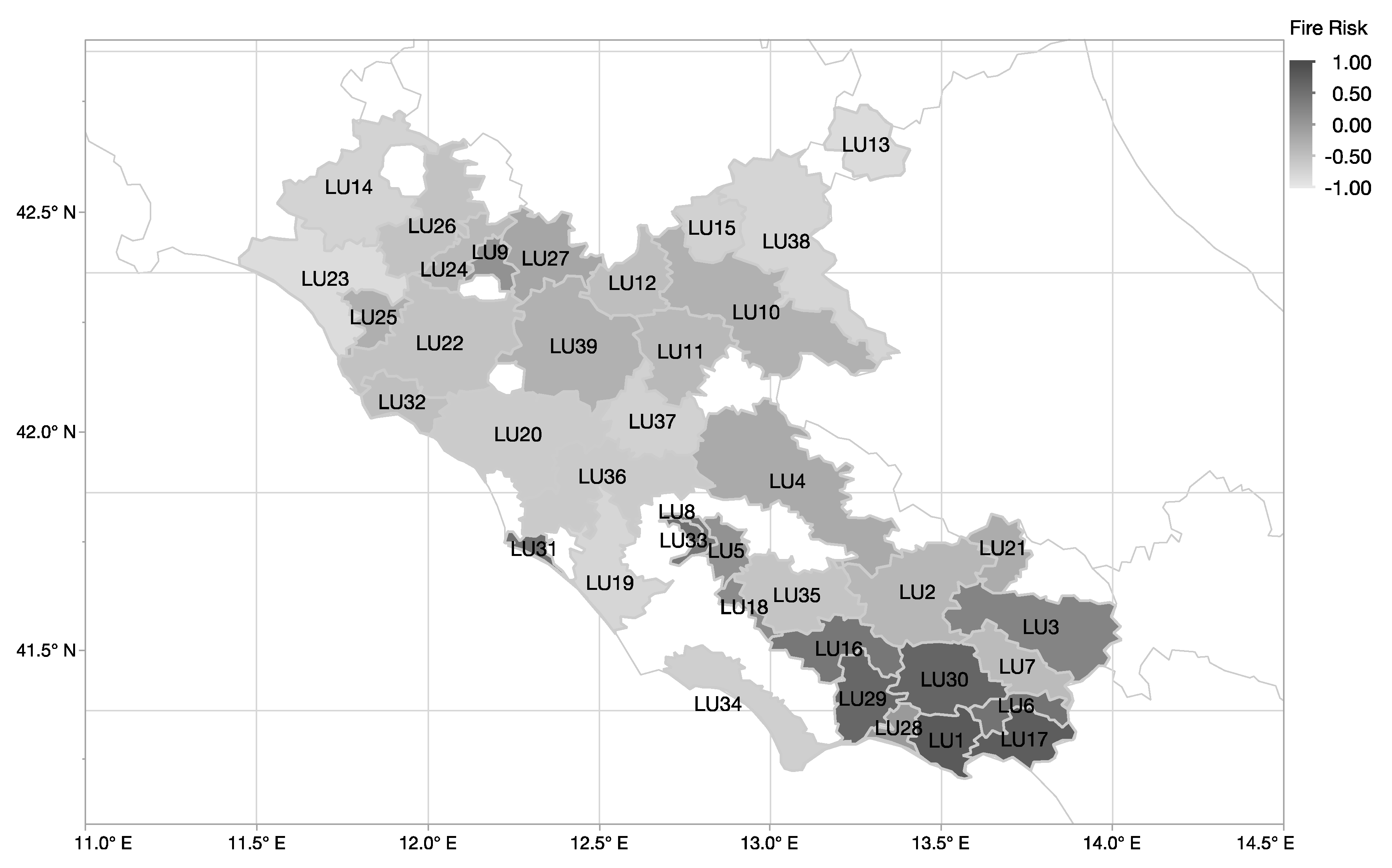
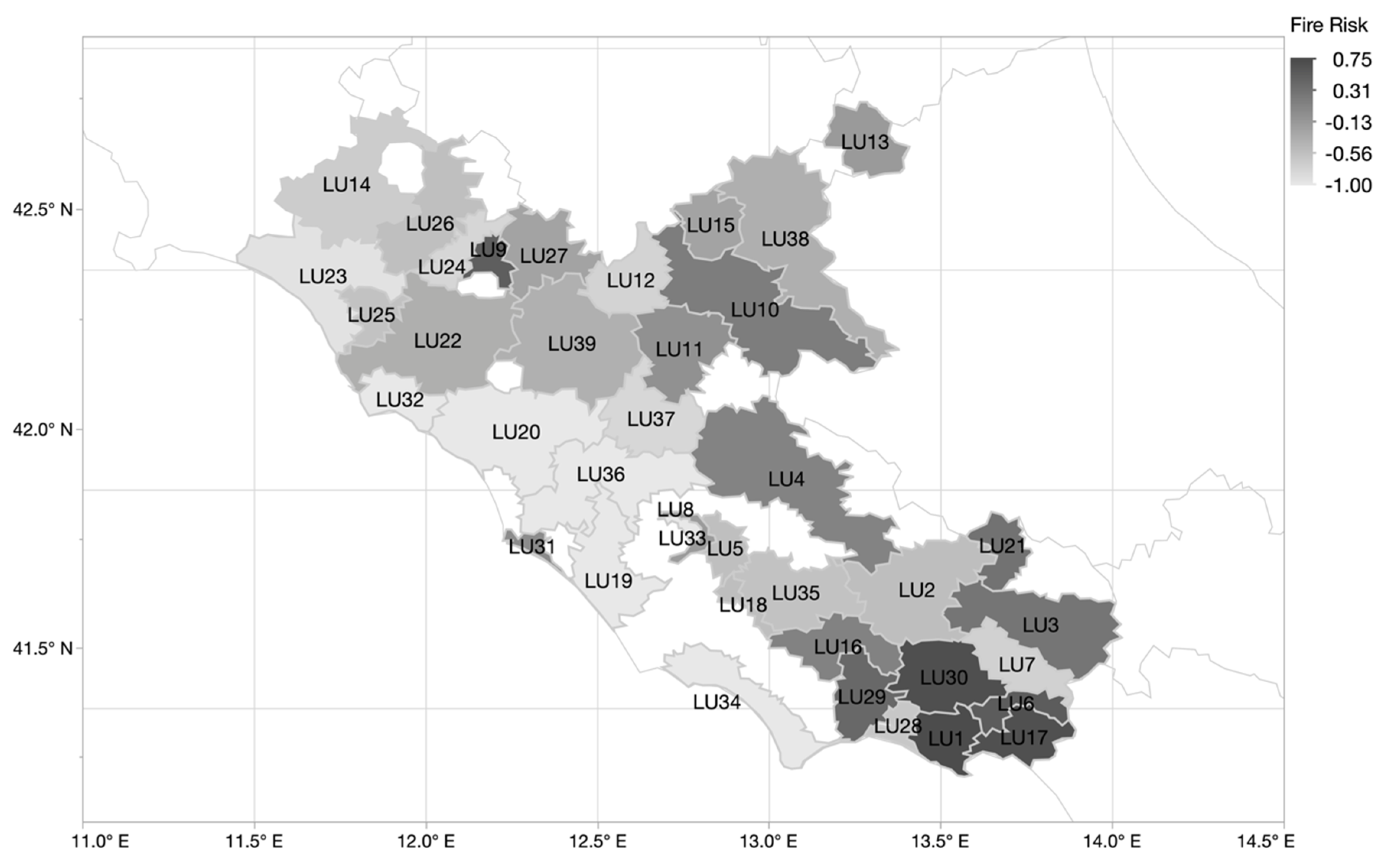
3. Results
4. Discussion
Author Contributions
Funding
Acknowledgments
Conflicts of Interest
References
- Krebs, P.; Pezzatti, G.B.; Mazzoleni, S.; Talbot, L.M.; Conedera, M. Fire regime: History and definition of a key concept in disturbance ecology. Theory Biosci. 2010, 129, 53–69. [Google Scholar] [CrossRef] [PubMed]
- Keeley, J.E.; Pausas, J.G. A burning story: The role of fire in the history of life. Bioscience 2009, 59, 593–601. [Google Scholar]
- Marlon, J.R.; Bartlein, P.J.; Gavin, D.G.; Long, C.J.; Anderson, R.S.; Briles, C.E.; Brown, K.J.; Colombaroli, D.; Hallett, D.J.; Power, M.J.; et al. Long-term perspective on wildfires in the western USA. Proc. Natl. Acad. Sci. USA 2012, 109, E535–E543. [Google Scholar] [CrossRef] [PubMed]
- Bowman, D.M.J.S.; Balch, J.; Artaxo, P.; Bond, W.J.; Cochrane, M.A.; D’Antonio, C.M.; DeFries, R.; Johnston, F.H.; Keeley, J.E.; Krawchuk, M.A.; et al. The human dimension of fire regimes on Earth. J. Biogeogr. 2011, 38, 2223–2236. [Google Scholar] [CrossRef] [PubMed]
- Moreira, F.; Viedma, O.; Arianoutsou, M.; Curt, T.; Koutsias, N.; Rigolot, E.; Barbati, A.; Corona, P.; Vaz, P.; Xanthopoulos, G.; et al. Landscape-wildfire interactions in southern Europe: Implications for landscape management. J. Environ. Manag. 2011, 92, 2389–2402. [Google Scholar] [CrossRef] [PubMed]
- Bajocco, S.; Ricotta, C. Evidence of selective burning in Sardinia (Italy): Which land-cover classes do wildfires prefer? Landsc. Ecol. 2008, 23, 241–248. [Google Scholar] [CrossRef]
- Barros, A.M.G.; Pereira, J.M.C. Wildfire Selectivity for Land Cover Type: Does Size Matter? PLoS ONE 2014, 9, e84760. [Google Scholar] [CrossRef]
- Ricotta, C.; Bajocco, S.; Guglietta, D.; Conedera, M. Assessing the Influence of Roads on Fire Ignition: Does Land Cover Matter? Fire 2018, 1, 24. [Google Scholar] [CrossRef]
- Keeley, J.E. Fire. In Encyclopedia of Ecology; Jørgensen, S.E., Fath, B.D., Eds.; Academic Press: Oxford, UK, 2008; pp. 1557–1564. ISBN 978-0-08-045405-4. [Google Scholar]
- Curt, T. Fire Frequency. In Encyclopedia of Wildfires and Wildland-Urban Interface (WUI) Fires; Manzello, S.L., Ed.; Springer International Publishing: Cham, Switzerland, 2018; pp. 1–5. ISBN 978-3-319-51727-8. [Google Scholar]
- Hardy, C.C. Wildland fire hazard and risk: Problems, definitions, and context. For. Ecol. Manag. 2005, 211, 73–82. [Google Scholar] [CrossRef]
- Benali, A.; Mota, B.; Carvalhais, N.; Oom, D.; Miller, L.M.; Campagnolo, M.L.; Pereira, J.M.C. Bimodal fire regimes unveil a global-scale anthropogenic fingerprint. Glob. Ecol. Biogeogr. 2017, 26, 799–811. [Google Scholar] [CrossRef]
- Bond, W.J.; Keeley, J.E. Fire as a global ‘herbivore’: The ecology and evolution of flammable ecosystems. Trends Ecol. Evol. 2005, 20, 387–394. [Google Scholar] [CrossRef] [PubMed]
- Giglio, L.; Csiszar, I.; Justice, C.O. Global distribution and seasonality of active fires as observed with the Terra and Aqua Moderate Resolution Imaging Spectroradiometer (MODIS) sensors. J. Geophys. Res. 2006, 111, G02016. [Google Scholar] [CrossRef]
- Lestienne, M.; Hély, C.; Curt, T.; Jouffroy-Bapicot, I.; Vannière, B. Combining the Monthly Drought Code and Paleoecological Data to Assess Holocene Climate Impact on Mediterranean Fire Regime. Fire 2020, 3, 8. [Google Scholar] [CrossRef]
- Ruffault, J.; Mouillot, F. Contribution of human and biophysical factors to the spatial distribution of forest fire ignitions and large wildfires in a French Mediterranean region. Int. J. Wildland Fire 2017, 26, 498–508. [Google Scholar] [CrossRef]
- Vannière, B.; Colombaroli, D.; Chapron, E.; Leroux, A.; Tinner, W.; Magny, M. Climate versus human-driven fire regimes in Mediterranean landscapes: The Holocene record of Lago dell’Accesa (Tuscany, Italy). Quat. Sci. Rev. 2008, 27, 1181–1196. [Google Scholar] [CrossRef]
- Ganteaume, A.; Camia, A.; Jappiot, M.; San-Miguel-Ayanz, J.; Long-Fournel, M.; Lampin, C. A Review of the Main Driving Factors of Forest Fire Ignition over Europe. Environ. Manag. 2013, 51, 651–662. [Google Scholar] [CrossRef]
- Bal, M.-C.; Pelachs, A.; Perez-Obiol, R.; Julia, R.; Cunill, R. Fire history and human activities during the last 3300cal yr BP in Spain’s Central Pyrenees: The case of the Estany de Burg. Palaeogeogr. Palaeoclimatol. Palaeoecol. 2011, 300, 179–190. [Google Scholar] [CrossRef]
- Mateus, P.; Fernandes, P.M. Forest Fires in Portugal: Dynamics, Causes and Policies. In Forest Context and Policies in Portugal: Present and Future Challenges; Reboredo, F., Ed.; Springer International Publishing: Cham, Switzerland, 2014; pp. 97–115. ISBN 978-3-319-08455-8. [Google Scholar]
- Vilar, L.; Camia, A.; San-Miguel-Ayanz, J.; Martín, M.P. Modeling temporal changes in human-caused wildfires in Mediterranean Europe based on Land Use-Land Cover interfaces. For. Ecol. Manag. 2016, 378, 68–78. [Google Scholar] [CrossRef]
- Lasslop, G.; Kloster, S. Human impact on wildfires varies between regions and with vegetation productivity. Environ. Res. Lett. 2017, 12, 115011. [Google Scholar] [CrossRef]
- McWethy, D.B.; Whitlock, C.; Wilmshurst, J.M.; McGlone, M.S.; Fromont, M.; Li, X.; Dieffenbacher-Krall, A.; Hobbs, W.O.; Fritz, S.C.; Cook, E.R. Rapid landscape transformation in South Island, New Zealand, following initial Polynesian settlement. Proc. Natl. Acad. Sci. USA 2010, 107, 21343. [Google Scholar] [CrossRef]
- Bajocco, S.; Koutsias, N.; Ricotta, C. Linking fire ignitions hotspots and fuel phenology: The importance of being seasonal. Ecol. Indic. 2017, 82, 433–440. [Google Scholar] [CrossRef]
- Gonzalez-Olabarria, J.R.; Brotons, L.; Gritten, D.; Tudela, A.; Teres, J.A. Identifying location and causality of fire ignition hotspots in a Mediterranean region. Int. J. Wildland Fire 2012, 21, 905–914. [Google Scholar] [CrossRef]
- San-Miguel-Ayanz, J.; Moreno, J.M.; Camia, A. Analysis of large fires in European Mediterranean landscapes: Lessons learned and perspectives. For. Ecol. Manag. 2013, 294, 11–22. [Google Scholar] [CrossRef]
- Balch, J.K.; Bradley, B.A.; Abatzoglou, J.T.; Nagy, R.C.; Fusco, E.J.; Mahood, A.L. Human-started wildfires expand the fire niche across the United States. Proc. Natl. Acad. Sci. USA 2017, 114, 2946. [Google Scholar] [CrossRef] [PubMed]
- Le Page, Y.; Oom, D.; Silva, J.M.N.; Jönsson, P.; Pereira, J.M.C. Seasonality of vegetation fires as modified by human action: Observing the deviation from eco-climatic fire regimes. Glob. Ecol. Biogeogr. 2010, 19, 575–588. [Google Scholar] [CrossRef]
- Magi, B.I.; Rabin, S.; Shevliakova, E.; Pacala, S. Separating agricultural and non-agricultural fire seasonality at regional scales. Biogeosciences 2012, 9, 3003–3012. [Google Scholar] [CrossRef]
- Watts, J.M.; Hall, J.R. Introduction to Fire Risk Analysis. In SFPE Handbook of Fire Protection Engineering; Hurley, M.J., Gottuk, D., Hall, J.R., Harada, K., Kuligowski, E., Puchovsky, M., Torero, J., Watts, J.M., Wieczorek, C., Eds.; Springer New York: New York, NY, USA, 2016; pp. 2817–2826. ISBN 978-1-4939-2565-0. [Google Scholar]
- Abedi Gheshlaghi, H.; Feizizadeh, B.; Blaschke, T. GIS-based forest fire risk mapping using the analytical network process and fuzzy logic. J. Environ. Plan. Manag. 2020, 63, 481–499. [Google Scholar] [CrossRef]
- Ziccardi, L.G.; Thiersch, C.R.; Yanai, A.M.; Fearnside, P.M.; Ferreira-Filho, P.J. Forest fire risk indices and zoning of hazardous areas in Sorocaba, São Paulo state, Brazil. J. For. Res. 2020, 31, 581–590. [Google Scholar] [CrossRef]
- Sirca, C.; Casula, F.; Bouillon, C.; García, B.F.; Fernández Ramiro, M.M.; Molina, B.V.; Spano, D. A wildfire risk oriented GIS tool for mapping Rural-Urban Interfaces. Environ. Model. Softw. 2017, 94, 36–47. [Google Scholar] [CrossRef]
- Huete, A.; Didan, K.; Miura, T.; Rodriguez, E.P.; Gao, X.; Ferreira, L.G. Overview of the radiometric and biophysical performance of the MODIS vegetation indices. Remote Sens. Environ. 2002, 83, 195–213. [Google Scholar] [CrossRef]
- Bajocco, S.; Dragozi, E.; Gitas, I.; Smiraglia, D.; Salvati, L.; Ricotta, C. Mapping forest fuels through vegetation phenology: The role of coarse-resolution satellite time-series. PLoS ONE 2015, 10. [Google Scholar] [CrossRef] [PubMed]
- Incerti, G.; Giordano, D.; Stinca, A.; Senatore, M.; Termolino, P.; Mazzoleni, S.; Bonanomi, G. Fire occurrence and tussock size modulate facilitation by Ampelodesmos mauritanicus. Acta Oecolo. 2013, 49, 116–124. [Google Scholar] [CrossRef]
- Vega Orozco, C.; Tonini, M.; Conedera, M.; Kanveski, M. Cluster recognition in spatial-temporal sequences: The case of forest fires. GeoInformatica 2012, 16, 653–673. [Google Scholar] [CrossRef]
- Zhao, F.; Liu, Y.; Shu, L. Change in the fire season pattern from bimodal to unimodal under climate change: The case of Daxing’anling in Northeast China. Agric. For. Meteorol. 2020, 291, 108075. [Google Scholar] [CrossRef]
- Costafreda-Aumedes, S.; Comas, C.; Vega-Garcia, C. Spatio-Temporal Configurations of Human-Caused Fires in Spain through Point Patterns. Forests 2016, 7, 185. [Google Scholar] [CrossRef]
- Chas-Amil, M.L.; Prestemon, J.P.; McClean, C.J.; Touza, J. Human-ignited wildfire patterns and responses to policy shifts. Appl. Geogr. 2015, 56, 164–176. [Google Scholar] [CrossRef]
- Loureiro, M.L.; Barreal, J. Modelling spatial patterns and temporal trends of wildfires in Galicia (NW Spain). For. Syst. 2015, 24, e022. [Google Scholar] [CrossRef]
- Ascoli, D.; Bovio, G. Prescribed burning in Italy: Issues, advances and challenges. iForest Biogeosciences For. 2013, 6, 79–89. [Google Scholar] [CrossRef]
- Coughlan, M.R. Farmers, flames, and forests: Historical ecology of pastoral fire use and landscape change in the French Western Pyrenees, 1830–2011. For. Ecol. Manag. 2014, 312, 55–66. [Google Scholar] [CrossRef]
- Bajocco, S.; Ferrara, C.; Guglietta, D.; Ricotta, C. Fifteen years of changes in fire ignition frequency in Sardinia (Italy): A rich-get-richer process. Ecol. Indic. 2019, 104, 543–548. [Google Scholar] [CrossRef]


| Urban Areas | Arable Land | Permanent Crops | Heterogeneous Agriculture | Forests | Grasslands | Shrublands | |
|---|---|---|---|---|---|---|---|
| Sσ | −0.050 | −0.491 *** | 0.127 | −0.049 | −0.354 * | 0.802 *** | 0.463 ** |
| Wσ | −0.197 | −0.569 *** | 0.164 | −0.190 | 0.085 | 0.556 *** | 0.373 * |
© 2020 by the authors. Licensee MDPI, Basel, Switzerland. This article is an open access article distributed under the terms and conditions of the Creative Commons Attribution (CC BY) license (http://creativecommons.org/licenses/by/4.0/).
Share and Cite
Bajocco, S.; Ferrara, C.; Guglietta, D.; Ricotta, C. Easy-To-Interpret Procedure to Analyze Fire Seasonality and the Influence of Land Use in Fire Occurrence: A Case Study in Central Italy. Fire 2020, 3, 46. https://doi.org/10.3390/fire3030046
Bajocco S, Ferrara C, Guglietta D, Ricotta C. Easy-To-Interpret Procedure to Analyze Fire Seasonality and the Influence of Land Use in Fire Occurrence: A Case Study in Central Italy. Fire. 2020; 3(3):46. https://doi.org/10.3390/fire3030046
Chicago/Turabian StyleBajocco, Sofia, Carlotta Ferrara, Daniela Guglietta, and Carlo Ricotta. 2020. "Easy-To-Interpret Procedure to Analyze Fire Seasonality and the Influence of Land Use in Fire Occurrence: A Case Study in Central Italy" Fire 3, no. 3: 46. https://doi.org/10.3390/fire3030046
APA StyleBajocco, S., Ferrara, C., Guglietta, D., & Ricotta, C. (2020). Easy-To-Interpret Procedure to Analyze Fire Seasonality and the Influence of Land Use in Fire Occurrence: A Case Study in Central Italy. Fire, 3(3), 46. https://doi.org/10.3390/fire3030046