A Geospatial Framework to Assess Fireline Effectiveness for Large Wildfires in the Western USA


 , and
, and
Abstract
:1. Introduction
2. Materials and Methods
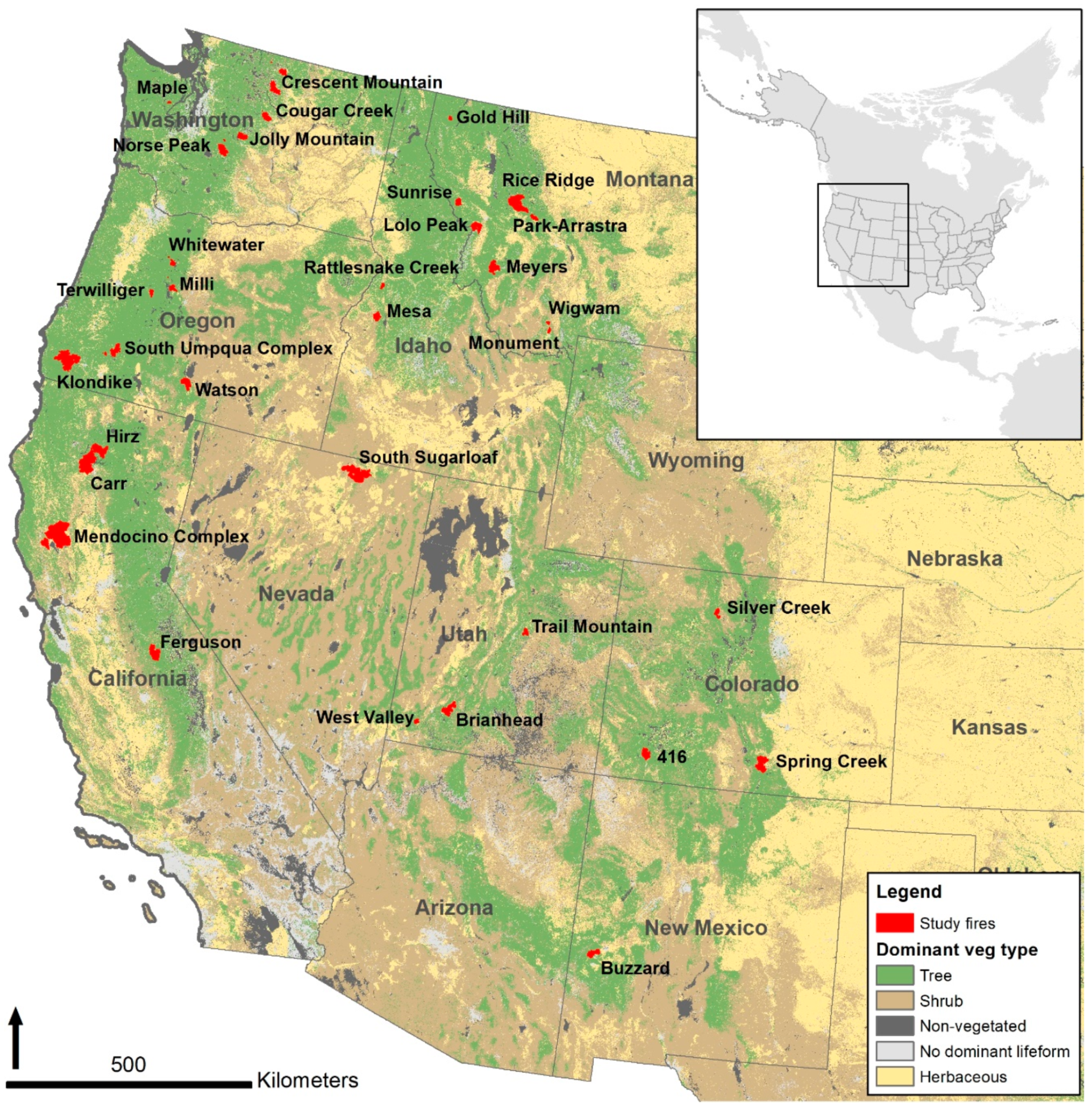
2.1. Case Study Fires
2.2. Data Cleaning
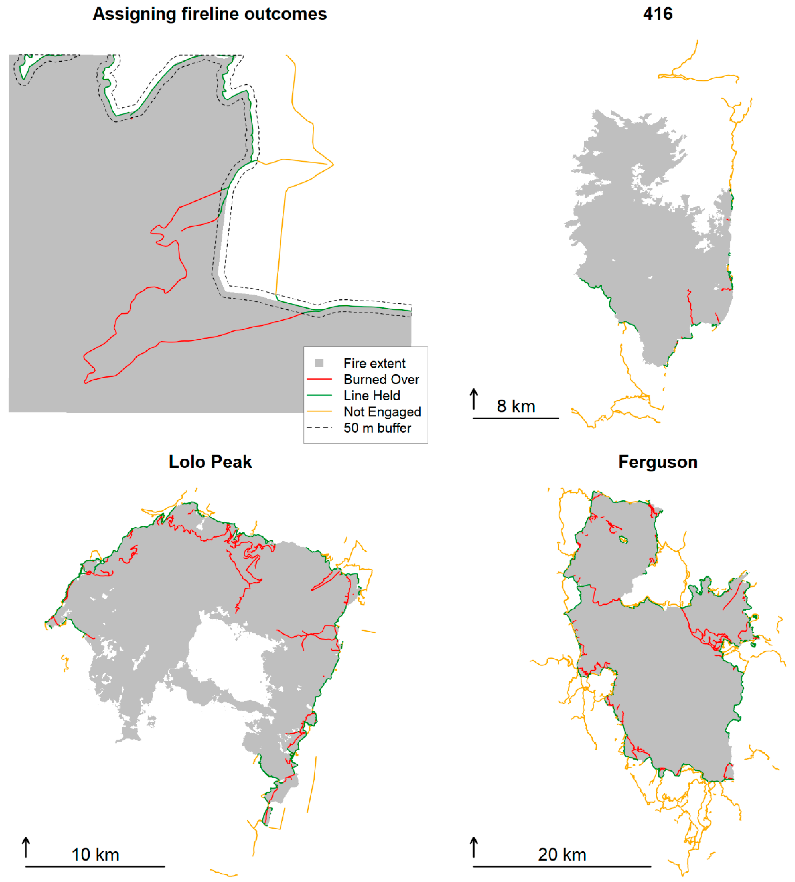
2.3. Attributing Firelines with Outcomes
2.4. Performance Metrics of Fireline Effectiveness
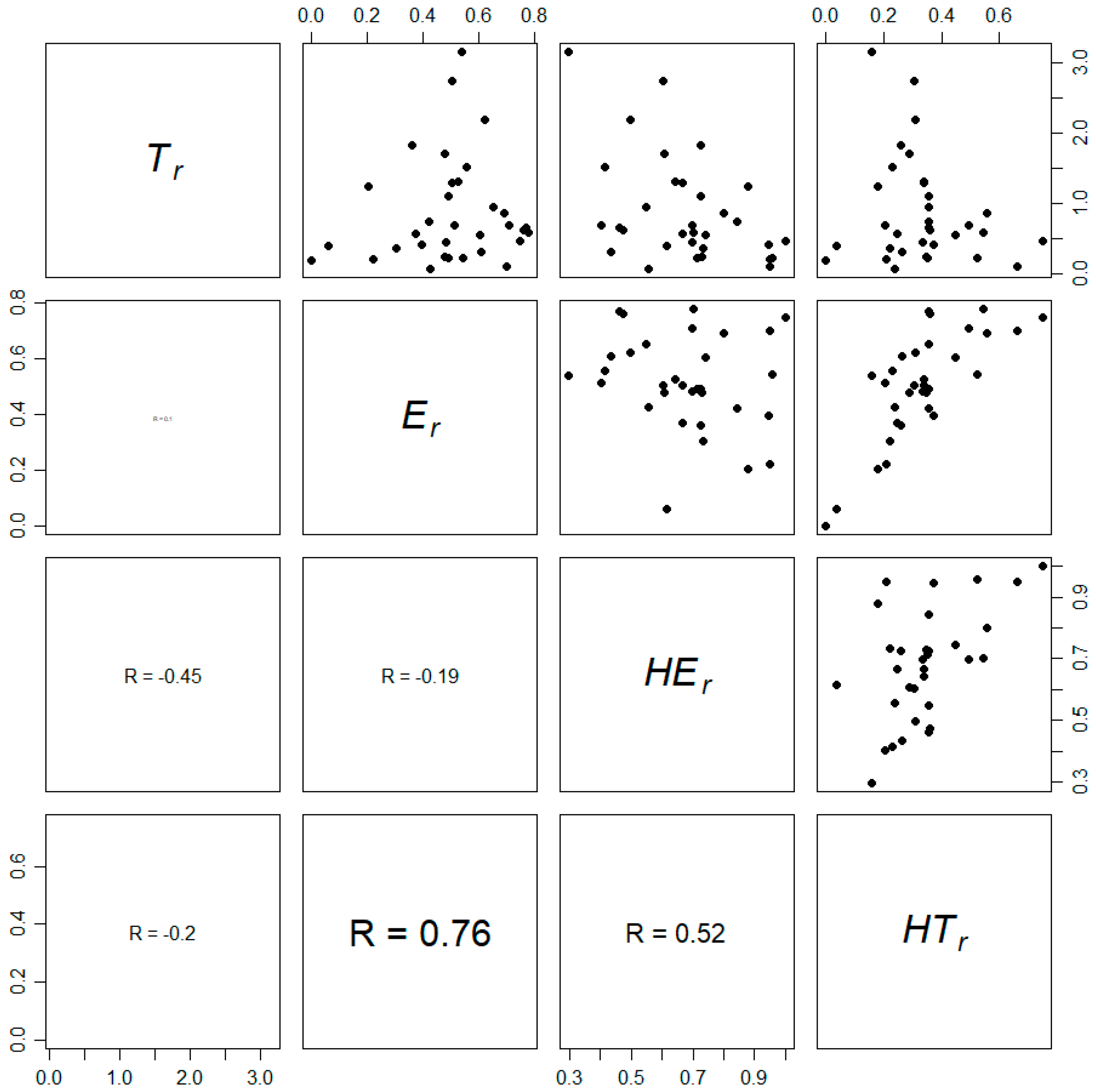
- Tr—total fireline length to perimeter ratioThis ratio describes the relative suppression level on the fire. Lower Tr means less suppression effort devoted to building fireline, and higher Tr means more suppression. Tr of one means total fireline length matched the fire perimeter length, which would, in theory, lead to fire containment if perfectly planned and executed.
- Er—engaged to total fireline ratioEngagement with fire is a pre-condition for fireline to affect fire containment. Engaged fireline in this study includes the burned over and held categories. Fireline that does not engage with fire may reflect a primary line that was never reached because fire growth was misjudged or an alternative/contingency line that is warranted to provide an extra layer of protection for high valued assets should primary line breach.
- Her—held to engaged fireline ratioThis ratio describes the effectiveness of fireline that engaged with the fire. High HEr indicates fireline placement, construction specifications, and holding resources were sufficient to ensure a high probability of success, whereas low HEr indicates that much of the engaged fireline had a low probability of success for the conditions.
- HTr—held to total fireline ratioThis ratio describes the overall effectiveness of fireline considering both fireline engagement and whether it held. Using HTr as an effectiveness measure penalizes both line construction where it has little probability of success and excessive alternative/contingency line.
3. Results
3.1. Descriptive Statistics of Fire Characteristics and Performance Measures
3.2. Combining Measures to Evaluate Incident-level Performance
3.3. Performance Measures by Fireline Type
4. Discussion
4.1. Overview and General Synthesis
4.2. Data Quality and Analysis Limitations
4.3. Management Implications
Author Contributions
Funding
Acknowledgments
Conflicts of Interest
References
- Calkin, D.E.; Finney, M.A.; Ager, A.A.; Thompson, M.P.; Gebert, K.M. Progress towards and barriers to implementation of a risk framework for US federal wildland fire policy and decision making. Policy Econ. 2011, 13, 378–389. [Google Scholar] [CrossRef]
- Calkin, D.E.; Thompson, M.P.; Finney, M.A. Negative consequences of positive feedbacks in US wildfire management. Ecosystem 2015, 2, 9. [Google Scholar] [CrossRef] [Green Version]
- GAO. Wildland Fire Management: Agencies Have Made Several Key Changes but Could Benefit from More Information about Effectiveness; US Government Accountability Office Report GAO-15-772; GAO: Washington, DC, USA, 2015.
- Thompson, M.P.; Rodríguez y Silva, F.R.; Calkin, D.E.; Hand, M.S. A review of challenges to determining and demonstrating efficiency of large fire management. Int. J. Wildland Fire 2017, 26, 562–573. [Google Scholar] [CrossRef] [Green Version]
- Thompson, M.P.; Wei, Y.; Calkin, D.E.; O’Connor, C.D.; Dunn, C.J.; Anderson, N.M.; Hogland, J.S. Risk management and analytics in wildfire response. Curr. Rep. 2019, 5, 226–239. [Google Scholar] [CrossRef] [Green Version]
- Plucinski, M.P. Fighting flames and forging firelines: Wildfire suppression effectiveness at the fire edge. Curr. Rep. 2019, 5, 1–19. [Google Scholar] [CrossRef]
- Plucinski, M.P. Contain and control: Wildfire suppression effectiveness at incidents and across landscapes. Curr. Rep. 2019, 5, 20–40. [Google Scholar] [CrossRef]
- Filkov, A.I.; Duff, T.J.; Penman, T.D. Improving fire behaviour data obtained from wildfires. Forests 2018, 9, 81. [Google Scholar] [CrossRef] [Green Version]
- Thompson, M.P.; Lauer, C.J.; Calkin, D.E.; Rieck, J.D.; Stonesifer, C.S.; Hand, M.S. Wildfire response performance measurement: Current and future directions. Fire 2018, 1, 21. [Google Scholar] [CrossRef] [Green Version]
- Thompson, M.P.; Freeborn, P.; Rieck, J.D.; Calkin, D.E.; Gilbertson-Day, J.W.; Cochrane, M.A.; Hand, M.S. Quantifying the influence of previously burned areas on suppression effectiveness and avoided exposure: A case study of the Las Conchas Fire. Int. J. Wildland Fire 2016, 25, 167–181. [Google Scholar] [CrossRef]
- Bratten, F.W. Allocation Model for Firefighting Resource a Progress Report; Research Note PSW-214; USDA Forest Service Pacific Southwest Forest and Range Experiment Station: Berkeley, CA, USA, 1970.
- Fried, J.S.; Gilless, J.K. Expert opinion estimation of fireline production rates. Science 1989, 35, 870–877. [Google Scholar] [CrossRef]
- Fried, J.S.; Fried, B.D. Simulating wildfire containment with realistic tactics. Science 1996, 42, 267–281. [Google Scholar] [CrossRef]
- Mees, R.; Strauss, D. Allocating resources to large wildland fires: A model with stochastic production rates. Science 1992, 38, 842–853. [Google Scholar] [CrossRef]
- Calkin, D.; Phipps, J.; Holmes, T.; Rieck, J.; Thompson, M. The Exposure Index: Developing firefighter safety performance measures. Fire Manag. Today 2011, 71, 24–27. [Google Scholar]
- Holmes, T.P.; Calkin, D.E. Econometric analysis of fire suppression production functions for large wildland fires. Int. J. Wildland Fire 2012, 22, 246–255. [Google Scholar] [CrossRef] [Green Version]
- Katuwal, H.; Calkin, D.E.; Hand, M.S. Production and efficiency of large wildland fire suppression effort: A stochastic frontier analysis. J. Environ. Manag. 2016, 166, 227–236. [Google Scholar] [CrossRef]
- Dunn, C.J.; Thompson, M.P.; Calkin, D.E. A framework for developing safe and effective large-fire response in a new fire management paradigm. Ecol. Manag. 2017, 404, 184–196. [Google Scholar] [CrossRef]
- O’Connor, C.D.; Calkin, D.E. Engaging the fire before it starts: A case study from the 2017 Pinal Fire (Arizona). Wildfire Mag. 2019, 28, 14–18. [Google Scholar]
- Finney, M.; Grenfell, I.C.; McHugh, C.W. Modeling containment of large wildfires using generalized linear mixed-model analysis. Science 2009, 55, 249–255. [Google Scholar] [CrossRef]
- Jolly, W.M.; Freeborn, P.H. Towards improving wildland firefighter situational awareness through daily fire behaviour risk assessments in the US Northern Rockies and Northern Great Basin. Int. J. Wildland Fire 2017, 26, 574–586. [Google Scholar] [CrossRef]
- Thompson, M.P.; MacGregor, D.G.; Dunn, C.J.; Calkin, D.E.; Phipps, J. Rethinking the wildland fire management system. J. For. 2018, 116, 382–390. [Google Scholar] [CrossRef] [Green Version]
- Price, O.F.; Bradstock, R.A. The effect of fuel age on the spread of fire in sclerophyll forest in the Sydney region of Australia. Int. J. Wildland Fire 2010, 19, 35–45. [Google Scholar] [CrossRef] [Green Version]
- O’Connor, C.D.; Thompson, M.P.; Rodríguez y Silva, F. Getting ahead of the wildfire problem: Quantifying and mapping management challenges and opportunities. Geosciences 2016, 6, 35. [Google Scholar] [CrossRef] [Green Version]
- O’Connor, C.D.; Calkin, D.E.; Thompson, M.P. An empirical machine learning method for predicting potential fire control locations for pre-fire planning and operational fire management. Int. J. Wildland Fire 2017, 26, 587–597. [Google Scholar] [CrossRef]
- Yocom, L.L.; Jenness, J.; Fulé, P.Z.; Thode, A.E. Previous fires and roads limit wildfire growth in Arizona and New Mexico, USA. Ecol. Manag. 2019, 449, 117440. [Google Scholar] [CrossRef]
- Dunn, C.J.; O’Connor, C.D.; Abrams, J.; Thompson, M.P.; Calkin, D.E.; Johnston, J.D.; Stratton, R.; Gilbertson-Day, J. Wildfire risk science facilitates adaptation of fire-prone social-ecological systems to the new fire reality. Environ. Res. Lett. 2020, 15, 025001. [Google Scholar] [CrossRef]
- Rodrigues, M.; Alcasena, F.; Gelabert, P.; Vega-García, C. Geospatial Modeling of Containment Probability for Escaped Wildfires in a Mediterranean Region. Risk Anal. 2020. [Google Scholar] [CrossRef]
- NIFC. Spatial Fireline Records, 2017–2018; National Interagency Fire Center: Boise, ID, USA, 2017. Available online: www.nifc.gov (accessed on 1 November 2018).
- NWCG. Incident Status Summary Reports, 2017–2018; National Wildfire Coordinating Group: Washington, DC, USA, 2017. Available online: https://fam.nwcg.gov/fam-web/ (accessed on 1 June 2020).
- BLM. National Surface Management Agency Area Polygons; USDOI Bureau of Land Management: Washington, DC, USA, 2019. Available online: https://catalog.data.gov/dataset/blm-national-surface-management-agency-area-polygons-national-geospatial-data-asset-ngda (accessed on 16 November 2019).
- USFS. National Wilderness Areas and Roadless Areas; USDA Forest Service: Washington, DC, USA, 2019. Available online: https://data.fs.usda.gov/geodata/edw/datasets.php (accessed on 16 November 2019).
- Bright, E.A.; Rose, A.N.; Urban, M.L.; McKee, J.J. LandScan Global Digital Raster Data, CY 2016; Oak Ridge National Laboratory: Oak Ridge, TN, USA, 2017. Available online: https://landscan.ornl.gov/ (accessed on 24 October 2018).
- Anderson, H.E. Aids to Determining Fuel Models for Estimating Fire Behavior; USDA Forest Service, General Technical Report INT-122; Intermountain Forest and Range Experiment Station: Ogden, UT, USA, 1982. [Google Scholar]
- Tedim, F.; Leone, V.; Amraoui, M.; Bouillon, C.; Coughlan, M.R.; Delogu, G.M.; Fernandes, P.M.; Ferreira, C.; McCaffrey, S.; McGee, T.K.; et al. Defining extreme wildfire events: Difficulties, challenges, and impacts. Fire 2018, 1, 9. [Google Scholar] [CrossRef] [Green Version]
- Geo MAC. Historical Fire Perimeters, 2017–2018; Geospatial Multi-Agency Coordination Center: Washington, DC, USA, 2017. Available online: https://www.geomac.gov/ (accessed on 1 November 2018).
- NWCG. GIS Standard Operating Procedures on Incidents; National Wildfire Coordinating Group Geospatial Subcommittee PMS-936: Washington, DC, USA, 2014.
- LANDFIRE. Existing Vegetation Type Layer, Version 1.4.0; USDOI Geological Survey: Washington, DC, USA, 2016. Available online: https://www.landfire.gov/ (accessed on 3 October 2018).
- ESRI. ArcGIS Software, Version 10.3; Environmental Systems Research Institute: Redlands, CA, USA, 2015. [Google Scholar]
- R Core Team. R: A Language and Environment for Statistical Computing, Version 3.5.3; R Foundation for Statistical Computing: Vienna, Austria, 2019; Available online: https://www.R-project.org/ (accessed on 1 May 2019).
- Nowell, B.; Bodkin, C.P.; Bayoumi, D. Redundancy as a strategy in disaster response systems: A pathway to resilience or a recipe for disaster. J. Conting. Crisis Manag. 2017, 25, 123–135. [Google Scholar] [CrossRef]
- Gannon, B.M.; Wei, Y.; Thompson, M.P.; Scott, J.H.; Short, K.C. System analysis of wildfire-water supply risk in Colorado, U.S.A. with Monte Carlo wildfire and rainfall simulation. Risk Anal. 2020. under review. [Google Scholar]
- Wei, Y.; Thompson, M.P.; Belval, E.; Gannon, B.; Calkin, D.E.; O’Connor, C.D. Prototyping a modeling process to evaluate contingency fire containment strategies. Nat. Resour. Model. 2020. in revision. [Google Scholar]
- Balch, J.K.; Schoennagel, T.; Williams, A.P.; Abatzoglou, J.T.; Cattau, M.E.; Mietkiewicz, N.P.; St. Denis, L.A. Switching on the big burn of 2017. Fire 2018, 1, 17. [Google Scholar] [CrossRef] [Green Version]
- Broyles, G. Fireline Production Rates; USDA Forest Service, Program Report 5100-Fire Management 1151 1805-SDTDC; National Technology & Development: San Dimas, CA, USA, 2011. [Google Scholar]
- Clark, A.M.; Rashford, B.S.; McLeod, D.M.; Lieske, S.N.; Coupal, R.H.; Albeke, S.E. The impact of residential development pattern on wildland fire suppression expenditures. Land Econ. 2016, 92, 656–678. [Google Scholar] [CrossRef]
- Hand, M.S.; Thompson, M.P.; Calkin, D.E. Examining heterogeneity and wildfire management expenditures using spatially and temporally descriptive data. J. For. Econ. 2016, 22, 80–102. [Google Scholar] [CrossRef] [Green Version]
- Belval, E.J.; Wei, Y.; Calkin, D.E.; Stonesifer, C.S.; Thompson, M.P.; Tipton, J.R. Studying interregional wildland fire engine assignments for large fire suppression. Int. J. Wildland Fire 2017, 26, 642–653. [Google Scholar] [CrossRef]
- Belval, E.J.; O’Connor, C.D.; Thompson, M.P.; Hand, M.S. The Role of Previous Fires in the Management and Expenditures of Subsequent Large Wildfires. Fire 2019, 2, 57. [Google Scholar] [CrossRef] [Green Version]
- Bayham, J.; Belval, E.J.; Thompson, M.P.; Dunn, C.; Stonesifer, C.S.; Calkin, D.E. Weather, Risk, and Resource Orders on Large Wildland Fires in the Western US. Forests 2020, 11, 169. [Google Scholar] [CrossRef] [Green Version]
- Bayham, J.; Yoder, J.K. Resource Allocation under Fire. Land Econ. 2020, 96, 92–110. [Google Scholar] [CrossRef] [Green Version]
- Syphard, A.D.; Keeley, J.E.; Brennan, T.J. Comparing the role of fuel breaks across southern California national forests. Ecol. Manag. 2011, 261, 2038–2048. [Google Scholar] [CrossRef]
- Dingell, J.D., Jr. Conservation, Management, and Recreation Act; Public Law 116-9; US Congress: Washington, DC, USA, 2019.
- Wilson, A.A.G. Width of firebreak that is necessary to stop grass fires: Some field experiments. Can. J. Res. 1998, 18, 682–687. [Google Scholar] [CrossRef]
- Ingalsbee, T. Ecological Fire Use for Ecological Fire Management: Managing Large Wildfires by Design. In Proceedings of the Large Wildland Fires Conference, Missoula, MT, USA, 19–23 May 2014; Keane, R.E., Jolly, M., Parsons, R., Riley, K., Eds.; USDA Forest Service Rocky Mountain Research Station Proceedings RMRS-P-73: Fort Collins, CO, USA, 2015; pp. 120–127. [Google Scholar]
- Gonzalez-Olabarria, J.R.; Reynolds, K.M.; Larrañaga, A.; Garcia-Gonzalo, J.; Busquets, E.; Pique, M. Strategic and tactical planning to improve suppression efforts against large forest fires in the Catalonia region of Spain. Ecol. Manag. 2019, 432, 612–622. [Google Scholar] [CrossRef]
- Rodríguez y Silva, F.R.; O’Connor, C.D.; Thompson, M.P.; Martínez, J.R.M.; Calkin, D.E. Modelling suppression difficulty: Current and future applications. Int. J. Wildland Fire. 2020. [Google Scholar] [CrossRef]


| Fire | Area km2 | Perim. km | Burned over km | Held km | Not Engaged km | Tr ratio | Er ratio | HEr ratio | HTr ratio |
|---|---|---|---|---|---|---|---|---|---|
| Buzzard | 203.2 | 141.9 | 21.1 | 48.9 | 28.9 | 0.70 | 0.71 | 0.70 | 0.49 |
| 416 | 218.9 | 281.4 | 8.1 | 22.4 | 70.4 | 0.36 | 0.30 | 0.73 | 0.22 |
| West Valley | 47.6 | 72.8 | 0.0 | 24.9 | 8.3 | 0.46 | 0.75 | 1.00 | 0.75 |
| Spring Creek | 437.6 | 256.3 | 55.4 | 111.0 | 163.1 | 1.29 | 0.50 | 0.67 | 0.34 |
| Ferguson | 391.9 | 186.8 | 102.0 | 155.1 | 253.8 | 2.74 | 0.50 | 0.60 | 0.30 |
| Klondike | 923.6 | 816.1 | 173.8 | 117.0 | 276.6 | 0.70 | 0.51 | 0.40 | 0.21 |
| South Umpqua Complex | 219.2 | 330.0 | 81.6 | 146.5 | 206.2 | 1.32 | 0.53 | 0.64 | 0.34 |
| Carr | 929.4 | 390.5 | 192.3 | 135.9 | 262.0 | 1.51 | 0.56 | 0.41 | 0.23 |
| Silver Creek | 81.5 | 137.2 | 38.0 | 45.9 | 44.8 | 0.94 | 0.65 | 0.55 | 0.36 |
| Mendocino Complex | 1858.0 | 444.6 | 304.5 | 298.9 | 367.7 | 2.18 | 0.62 | 0.50 | 0.31 |
| Crescent Mountain | 312.9 | 468.9 | 33.1 | 66.3 | 168.4 | 0.57 | 0.37 | 0.67 | 0.25 |
| Cougar Creek | 167.9 | 167.1 | 25.1 | 65.9 | 94.1 | 1.11 | 0.49 | 0.72 | 0.36 |
| Wigwam | 16.6 | 61.4 | 0.1 | 2.6 | 9.6 | 0.20 | 0.22 | 0.95 | 0.21 |
| Monument | 26.8 | 69.5 | 0.0 | 0.0 | 13.7 | 0.20 | 0.00 | NA | 0.00 |
| Mesa | 140.6 | 120.7 | 14.3 | 57.9 | 32.1 | 0.86 | 0.69 | 0.80 | 0.55 |
| Rattlesnake Creek | 33.3 | 92.5 | 4.4 | 24.1 | 39.4 | 0.73 | 0.42 | 0.84 | 0.35 |
| Hirz | 445.0 | 222.2 | 71.3 | 109.9 | 198.7 | 1.71 | 0.48 | 0.61 | 0.29 |
| Terwilliger | 46.3 | 92.9 | 0.9 | 14.4 | 23.5 | 0.42 | 0.39 | 0.94 | 0.37 |
| South Sugarloaf | 945.4 | 377.5 | 52.1 | 121.4 | 49.8 | 0.59 | 0.78 | 0.70 | 0.54 |
| Watson Creek | 239.0 | 425.2 | 36.4 | 105.1 | 92.8 | 0.55 | 0.60 | 0.74 | 0.45 |
| Gold Hill | 26.3 | 40.3 | 7.2 | 19.1 | 47.2 | 1.82 | 0.36 | 0.73 | 0.26 |
| Maple | 13.3 | 37.3 | 0.1 | 2.5 | 1.1 | 0.10 | 0.70 | 0.95 | 0.66 |
| Brianhead | 290.1 | 451.1 | 13.9 | 37.4 | 56.5 | 0.24 | 0.48 | 0.73 | 0.35 |
| Meyers | 251.0 | 594.0 | 8.0 | 10.0 | 24.2 | 0.07 | 0.43 | 0.56 | 0.24 |
| Lolo Peak | 218.0 | 320.4 | 86.4 | 73.9 | 47.7 | 0.65 | 0.77 | 0.46 | 0.36 |
| Sunrise | 106.4 | 93.5 | 111.1 | 47.0 | 135.9 | 3.15 | 0.54 | 0.30 | 0.16 |
| Whitewater | 59.1 | 108.5 | 3.3 | 24.0 | 106.3 | 1.23 | 0.20 | 0.88 | 0.18 |
| Park Arrastra | 72.8 | 94.4 | 6.3 | 14.4 | 22.3 | 0.45 | 0.48 | 0.70 | 0.34 |
| Jolly Mountain | 149.0 | 249.0 | 8.0 | 20.0 | 29.0 | 0.23 | 0.49 | 0.72 | 0.35 |
| Norse Peak | 226.2 | 279.8 | 2.6 | 4.1 | 105.7 | 0.40 | 0.06 | 0.61 | 0.04 |
| Milli | 97.3 | 79.5 | 20.0 | 18.0 | 12.0 | 0.63 | 0.76 | 0.47 | 0.36 |
| Rice Ridge | 648.3 | 514.3 | 55.9 | 42.9 | 63.6 | 0.32 | 0.61 | 0.43 | 0.26 |
| Trail Mountain | 72.9 | 132.8 | 0.7 | 16.1 | 14.0 | 0.23 | 0.54 | 0.96 | 0.52 |
| Line Type | Total | Burned Over | Held | Not Engaged | Er | HEr | HTr |
|---|---|---|---|---|---|---|---|
| km | km, (%) | km, (%) | km, (%) | ratio | ratio | ratio | |
| Completed dozer line | 3441.0 | 879.5 | 1,000.3 | 1,561.2 | 0.55 | 0.53 | 0.29 |
| (25.6) | (29.1) | (45.4) | |||||
| Road as completed line | 2056.3 | 462.4 | 574.5 | 1,019.4 | 0.50 | 0.55 | 0.28 |
| (22.5) | (27.9) | (49.6) | |||||
| Completed hand line | 632.3 | 102.5 | 321.5 | 208.2 | 0.67 | 0.76 | 0.51 |
| (16.2) | (50.9) | (32.9) | |||||
| Line break completed | 165.1 | 6.5 | 18.4 | 140.3 | 0.15 | 0.74 | 0.11 |
| (3.9) | (11.1) | (84.9) | |||||
| Other | 159.8 | 56.1 | 10.5 | 93.2 | 0.42 | 0.16 | 0.07 |
| (35.1) | (6.6) | (58.3) | |||||
| Multiple methods | 135.3 | 26.7 | 64.1 | 44.6 | 0.67 | 0.71 | 0.47 |
| (19.7) | (47.3) | (32.9) | |||||
| Completed burnout | 13.1 | 1.8 | 9.9 | 1.5 | 0.89 | 0.85 | 0.75 |
| (13.4) | (75.4) | (11.1) | |||||
| Aerial retardant drop | 7.9 | 2.3 | 4.1 | 1.5 | 0.82 | 0.64 | 0.52 |
| (29.5) | (52.0) | (18.4) |
© 2020 by the authors. Licensee MDPI, Basel, Switzerland. This article is an open access article distributed under the terms and conditions of the Creative Commons Attribution (CC BY) license (http://creativecommons.org/licenses/by/4.0/).
Share and Cite
Gannon, B.M.; Thompson, M.P.; Deming, K.Z.; Bayham, J.; Wei, Y.; O’Connor, C.D. A Geospatial Framework to Assess Fireline Effectiveness for Large Wildfires in the Western USA. Fire 2020, 3, 43. https://doi.org/10.3390/fire3030043
Gannon BM, Thompson MP, Deming KZ, Bayham J, Wei Y, O’Connor CD. A Geospatial Framework to Assess Fireline Effectiveness for Large Wildfires in the Western USA. Fire. 2020; 3(3):43. https://doi.org/10.3390/fire3030043
Chicago/Turabian StyleGannon, Benjamin M., Matthew P. Thompson, Kira Z. Deming, Jude Bayham, Yu Wei, and Christopher D. O’Connor. 2020. "A Geospatial Framework to Assess Fireline Effectiveness for Large Wildfires in the Western USA" Fire 3, no. 3: 43. https://doi.org/10.3390/fire3030043