Decomposing the Interactions between Fire Severity and Canopy Fuel Structure Using Multi-Temporal, Active, and Passive Remote Sensing Approaches


Abstract
1. Introduction
2. Materials and Methods
2.1. Study Area
2.2. Remote Sensing Datasets
2.2.1. Spectral Reflectance Data
2.2.2. Airborne Laser Scanning Data
2.3. ALS Processing and Classification Methodology
2.3.1. Preprocessing
2.3.2. Classification of ALS Data
2.4. Data Analysis
2.4.1. Regression Analysis
2.4.2. Landscape Pattern Analysis
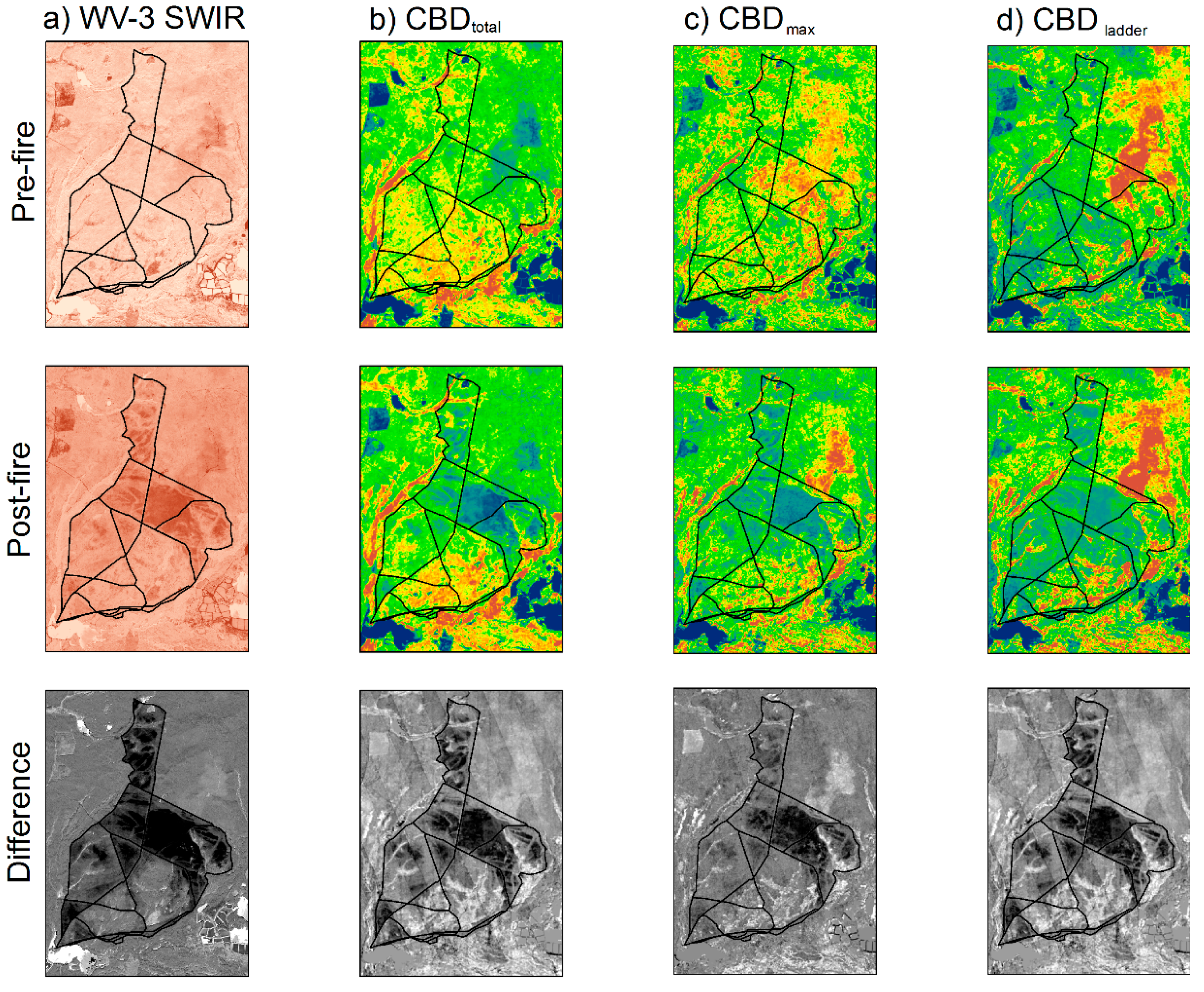
3. Results
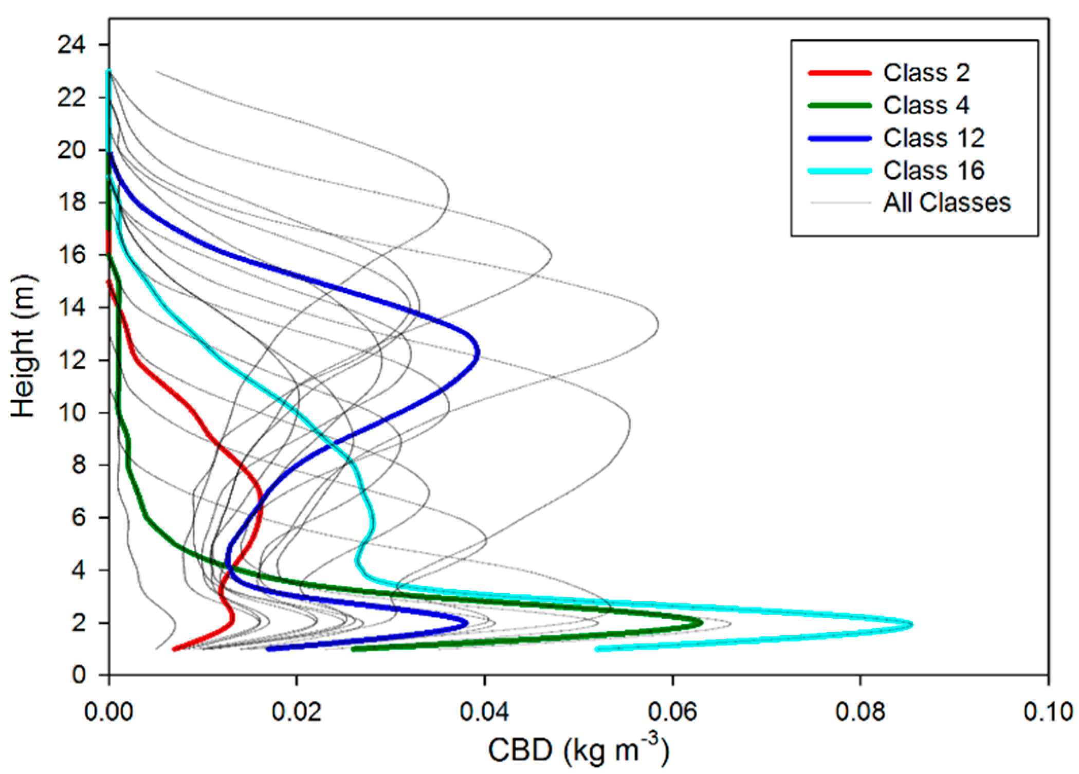
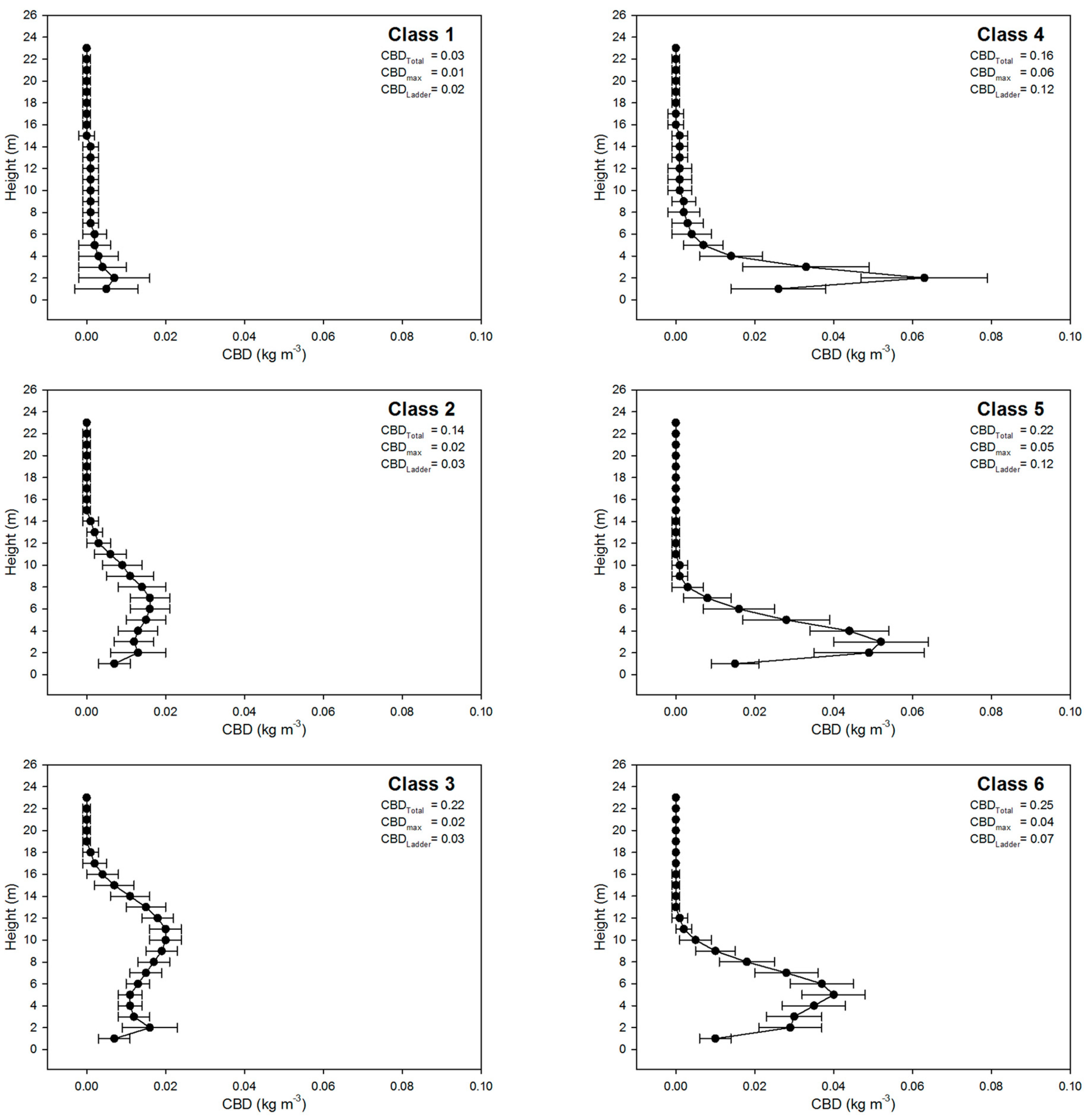
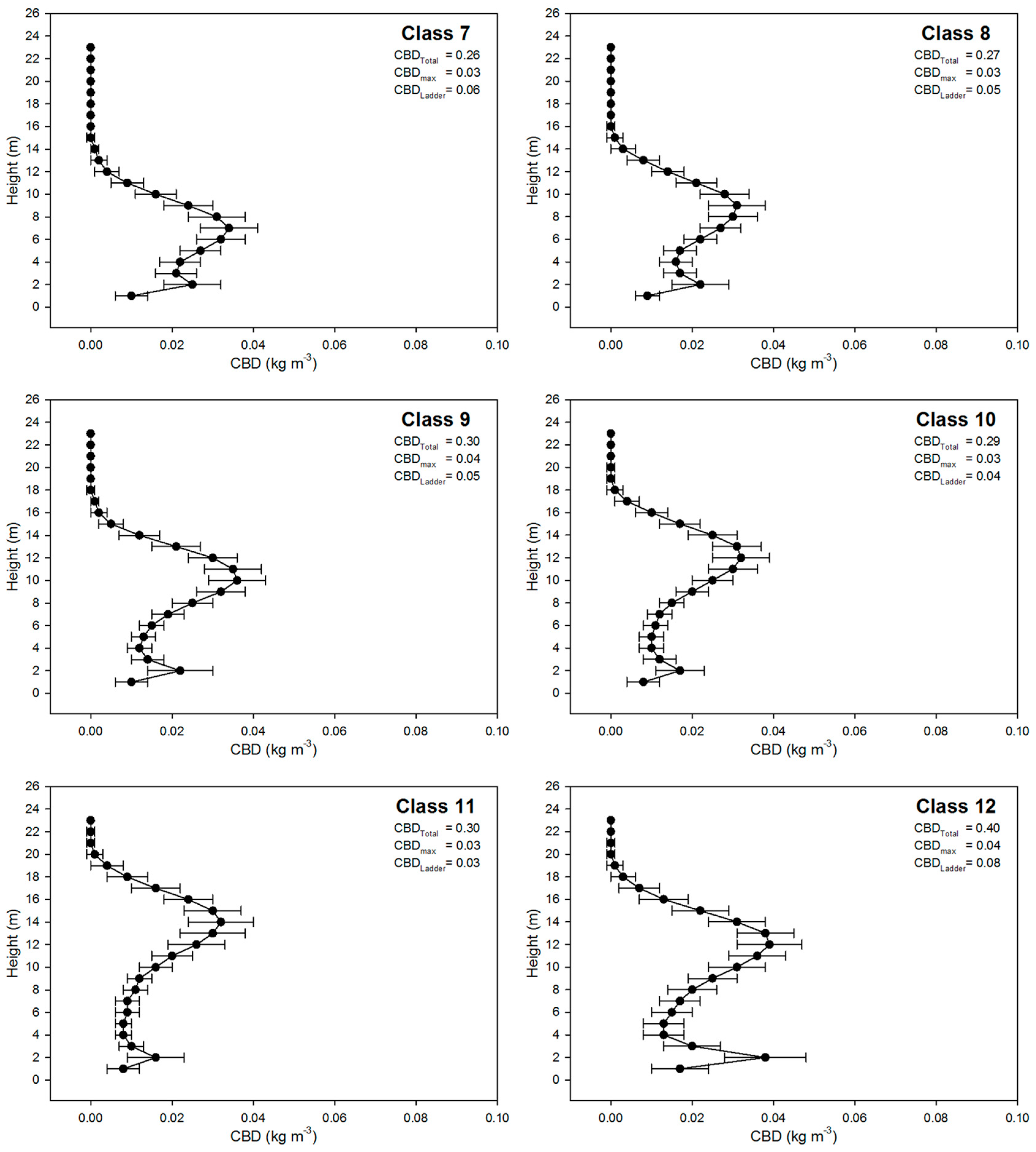
3.1. Canopy Fuel Characteristics
3.2. Canopy Classification Results
3.3. Regression Results
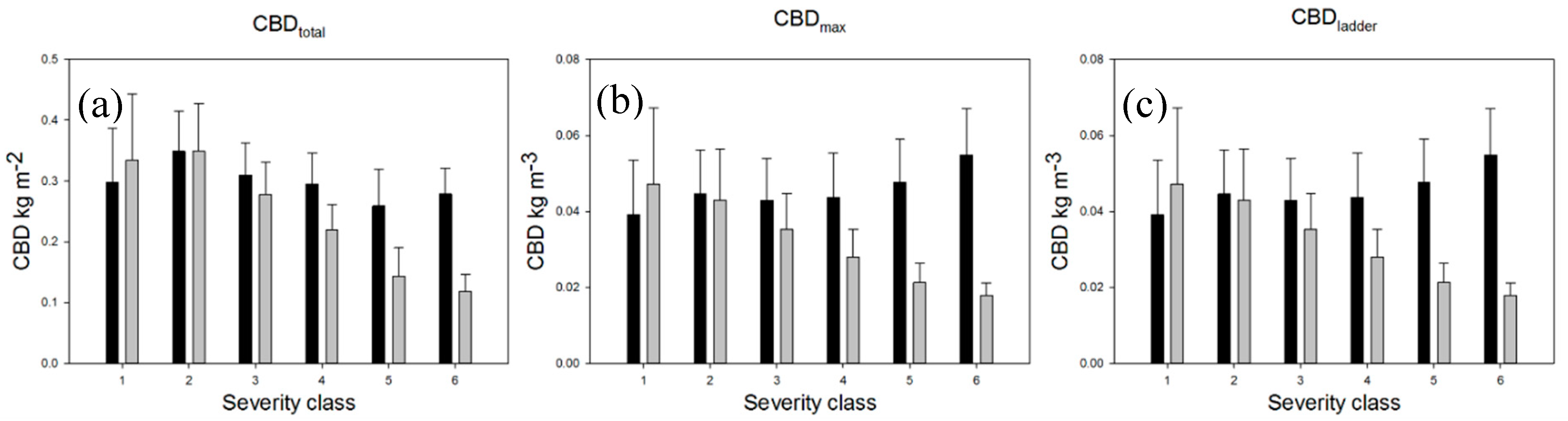
3.4. Changes in Canopy Structure
3.4.1. Canopy Fuel Changes
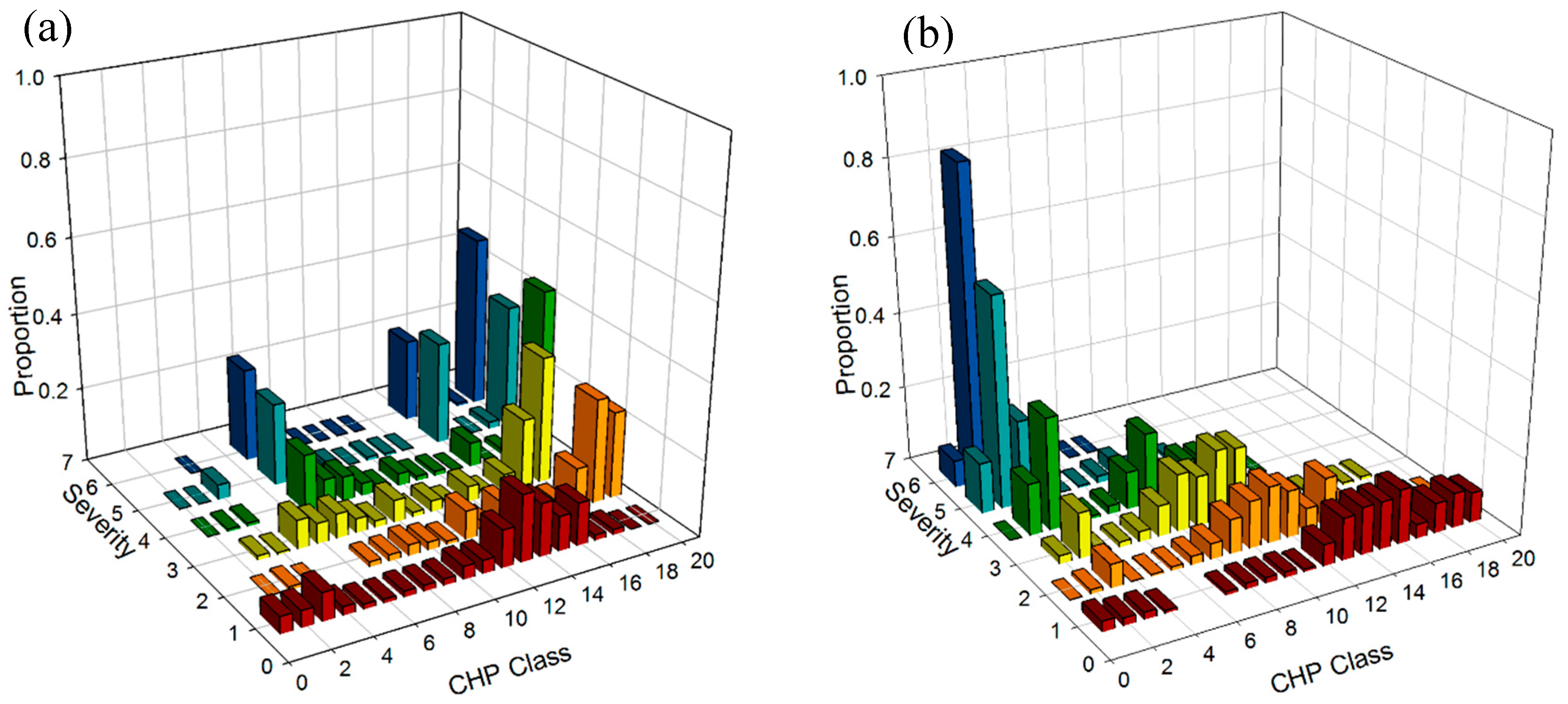
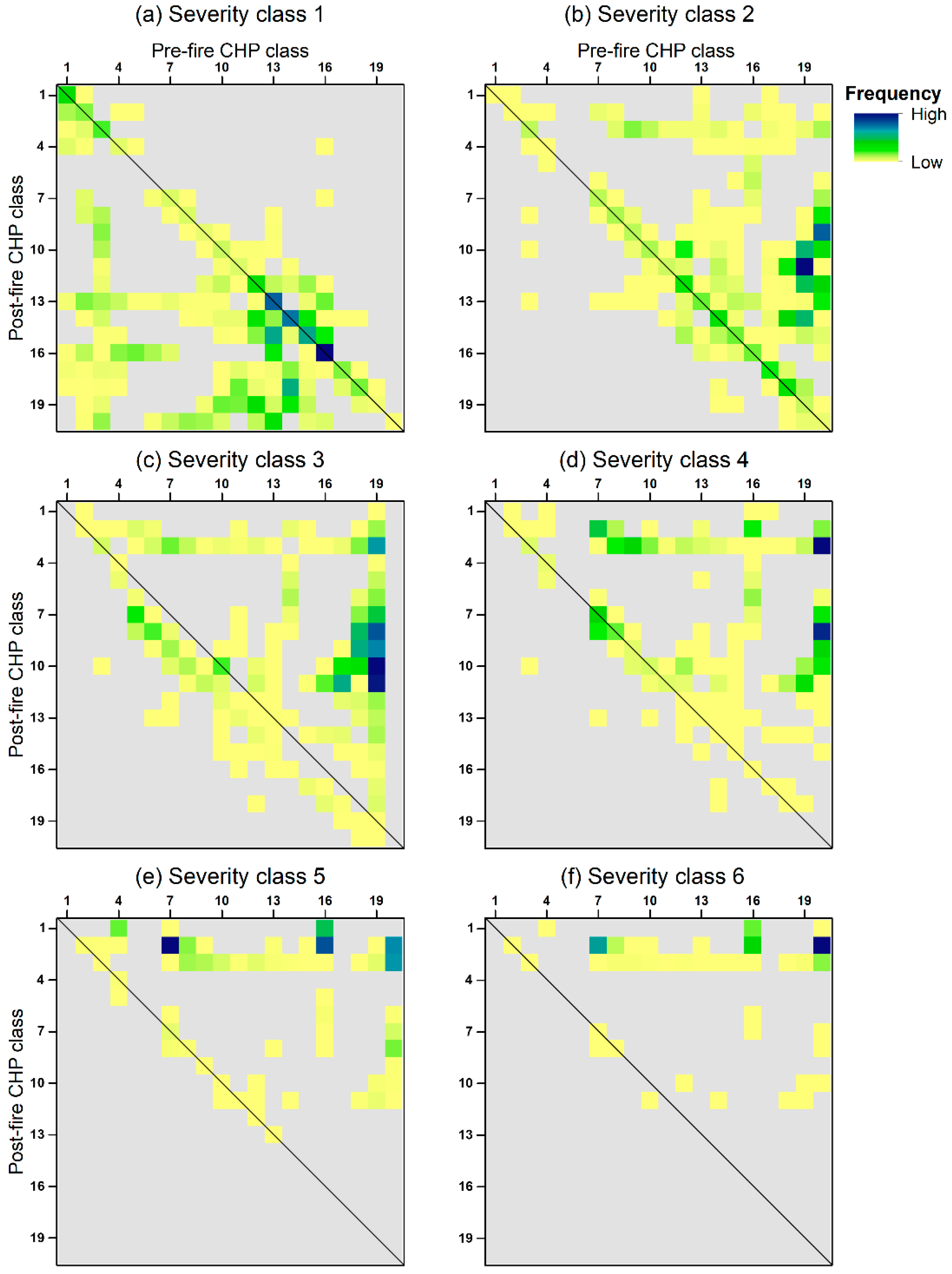
3.4.2. Canopy Class Change
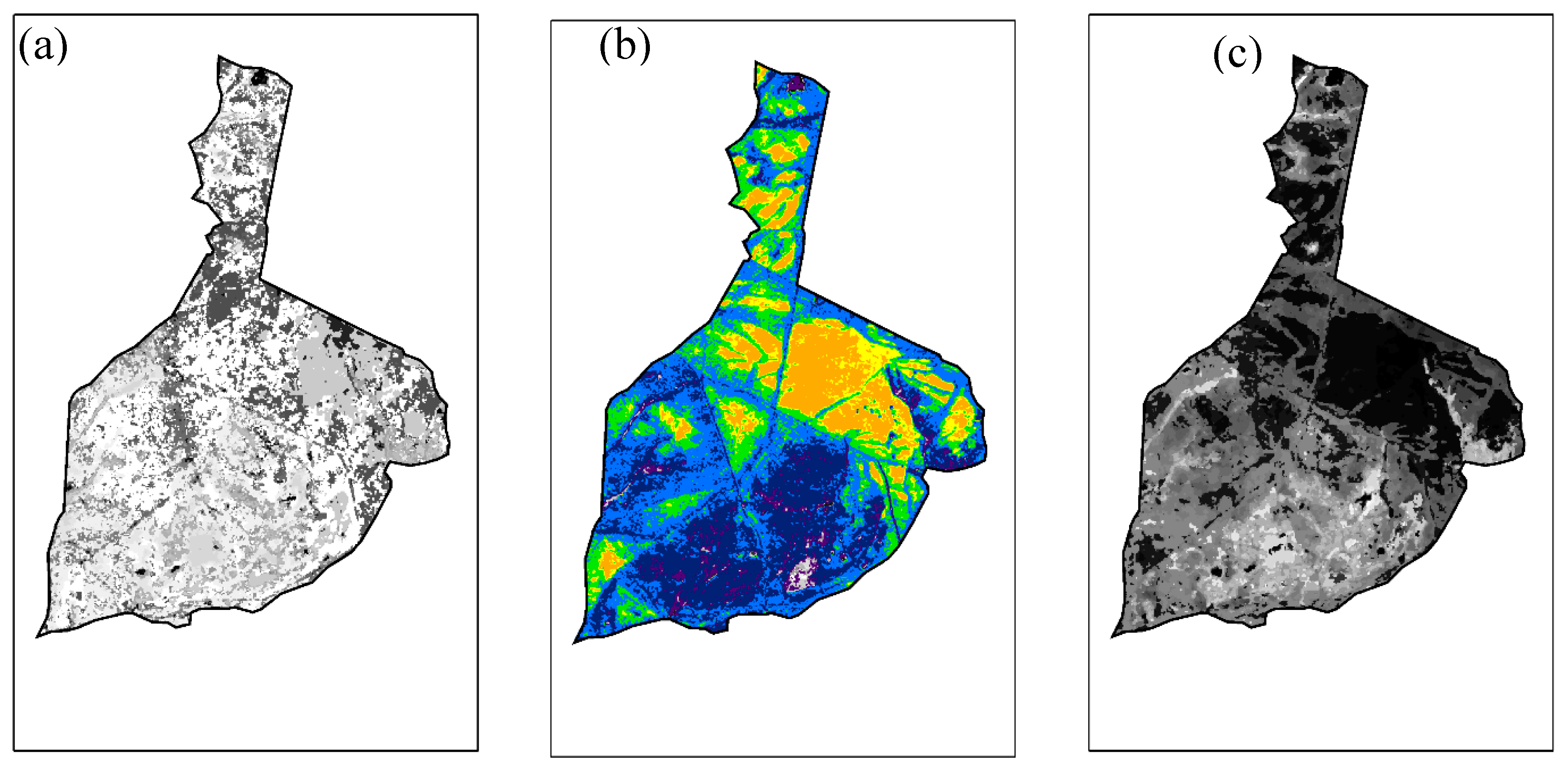
3.5. Spatial Patterning
4. Discussion and Conclusions
Author Contributions
Funding
Acknowledgments
Conflicts of Interest
Appendix A
ISODATA Classification Results


References
- Ellsworth, D.; Reich, P. Canopy structure and vertical patterns of photosynthesis and related leaf traits in a deciduous forest. Oecologia 1993, 96, 169–178. [Google Scholar] [CrossRef] [PubMed]
- Kreye, J.K.; Hiers, J.K.; Varner, J.M.; Hornsby, B.; Drukker, S.; O’brien, J.J. Effects of solar heating on the moisture dynamics of forest floor litter in humid environments: Composition, structure, and position matter. Can. J. For. Res. 2018, 48, 1331–1342. [Google Scholar] [CrossRef]
- Pedersen, B.S.; Howard, J.L. The influence of canopy gaps on overstory tree and forest growth rates in a mature mixed-age, mixed-species forest. For. Ecol. Manag. 2004, 196, 351–366. [Google Scholar] [CrossRef]
- Clark, K.; Renninger, H.; Skowronski, N.; Gallagher, M.; Schäfer, K. Decadal-scale reduction in forest net ecosystem production following insect defoliation contrasts with short-term impacts of prescribed fires. Forests 2018, 9, 145. [Google Scholar] [CrossRef]
- Lacki, M.J.; Dodd, L.E.; Skowronski, N.S.; Dickinson, M.B.; Rieske, L.K. Relationships among burn severity, forest canopy structure and bat activity from spring burns in oak–hickory forests. Int. J. Wildland Fire 2017, 26, 963–972. [Google Scholar] [CrossRef]
- Kaimal, J.C.; Finnigan, J.J. Atmospheric Boundary Layer Flows: Their Structure and Measurement; Oxford University Press: New York, NY, USA, 1994; p. 289. [Google Scholar]
- Xiao, Q.; McPherson, E.G.; Ustin, S.L.; Grismer, M.E. A new approach to modeling tree rainfall interception. J. Geophys. Res. Atmos. 2000, 105, 29173–29188. [Google Scholar] [CrossRef]
- Tanskanen, H.; Granström, A.; Venäläinen, A.; Puttonen, P. Moisture dynamics of moss-dominated surface fuel in relation to the structure of Picea abies and Pinus sylvestris stands. For. Ecol. Manag. 2006, 226, 189–198. [Google Scholar] [CrossRef]
- Kreye, J.K.; Varner, J.M.; Hiers, J.K.; Mola, J. Toward a mechanism for eastern North American forest mesophication: Differential litter drying across 17 species. Ecol. Appl. 2013, 23, 1976–1986. [Google Scholar] [CrossRef]
- Banerjee, T.; Heilman, W.; Goodrick, S.; Hiers, K.; Linn, R. Effects of canopy midstory management and fuel moisture on wildfire behavior. Available online: https://osf.io/4p57h (accessed on 9 March 2020).
- Mueller, E.V.; Skowronski, N.; Thomas, J.C.; Clark, K.; Gallagher, M.R.; Hadden, R.; Mell, W.; Simeoni, A. Local measurements of wildland fire dynamics in a field-scale experiment. Combust. Flame 2018, 194, 452–463. [Google Scholar] [CrossRef]
- Kiefer, M.T.; Zhong, S.; Heilman, W.E.; Charney, J.J.; Bian, X. A numerical study of atmospheric perturbations induced by heat from a wildland fire: Sensitivity to vertical canopy structure and heat source strength. J. Geophys. Res. Atmos. 2018, 123, 2555–2572. [Google Scholar] [CrossRef]
- Charney, J.J.; Kiefer, M.T.; Zhong, S.; Heilman, W.E.; Nikolic, J.; Bian, X.; Hom, J.L.; Clark, K.L.; Skowronski, N.S.; Gallagher, M.R. Assessing Forest Canopy Impacts on Smoke Concentrations Using a Coupled Numerical Model. Atmosphere 2019, 10, 273. [Google Scholar] [CrossRef]
- Mueller, E.V.; Skowronski, N.; Clark, K.; Gallagher, M.; Kremens, R.; Thomas, J.C.; El Houssami, M.; Filkov, A.; Hadden, R.M.; Mell, W. Utilization of remote sensing techniques for the quantification of fire behavior in two pine stands. Fire Saf. J. 2017, 91, 845–854. [Google Scholar] [CrossRef]
- O’Brien, J.J.; Loudermilk, E.L.; Hiers, J.K.; Pokswinski, S.M.; Hornsby, B.; Hudak, A.T.; Strother, D.; Rowell, E.; Bright, B.C. Canopy-derived fuels drive patterns of in-fire energy release and understory plant mortality in a longleaf pine (Pinus palustris) sandhill in northwest Florida, USA. Can. J. Remote Sens. 2016, 42, 489–500. [Google Scholar] [CrossRef]
- Pimont, F.; Dupuy, J.-L.; Linn, R.R.; Dupont, S. Impacts of tree canopy structure on wind flows and fire propagation simulated with FIRETEC. Ann. For. Sci. 2011, 68, 523. [Google Scholar] [CrossRef]
- Finney, M.A.; Andrews, P.L. FARSITE—a program for fire growth simulation. Fire Manag. Notes 1999, 59, 13–15. [Google Scholar]
- Linn, R.; Reisner, J.; Colman, J.J.; Winterkamp, J. Studying wildfire behavior using FIRETEC. Int. J. Wildland Fire 2002, 11, 233–246. [Google Scholar] [CrossRef]
- Smith, A.M.S.; Sparks, A.M.; Kolden, C.A.; Abatzoglou, J.T.; Talhelm, A.F.; Johnson, D.M.; Boschetti, L.; Lutz, J.A.; Apostol, K.G.; Yedinak, K.M. Towards a new paradigm in fire severity research using dose–response experiments. Int. J. Wildland Fire 2016, 25, 158–166. [Google Scholar] [CrossRef]
- Turner, M.G.; Romme, W.H. Landscape dynamics in crown fire ecosystems. Landsc. Ecol. 1994, 9, 59–77. [Google Scholar] [CrossRef]
- Key, C.H.; Benson, N.C. Landscape Assessment (LA) Sampling and Analysis Methods. In FIREMON: Fire Effects Monitoring and Inventory System; Lutes, D.C., Keane, R.E., Caratti, J.F., Key, C.H., Benson, N.C., Sutherland, S., Gangi, L.J., Eds.; USDA Forest Service–Rocky Mountain Research Station: Ogden, UT, USA, 2005. [Google Scholar]
- Lentile, L.B.; Smith, A.M.S.; Hudak, A.T.; Morgan, P.; Bobbitt, M.J.; Lewis, S.A.; Robichaud, P.R. Remote sensing for prediction of 1-year post-fire ecosystem condition. Int. J. Wildland Fire 2009, 18, 594–608. [Google Scholar] [CrossRef]
- McCarley, T.R.; Kolden, C.A.; Vaillant, N.M.; Hudak, A.T.; Smith, A.M.S.; Kreitler, J. Landscape-scale quantification of fire-induced change in canopy cover following mountain pine beetle outbreak and timber harvest. For. Ecol. Manag. 2017, 391, 164–175. [Google Scholar] [CrossRef]
- Kolden, C.A.; Smith, A.M.S.; Abatzoglou, J.T. Limitations and utilisation of Monitoring Trends in Burn Severity products for assessing wildfire severity in the USA. Int. J. Wildland Fire 2015, 24, 1023–1028. [Google Scholar] [CrossRef]
- Hall, D.K.; Ormsby, J.P.; Johnson, L.; Brown, J. Landsat digital analysis of the initial recovery of burned tundra at Kokolik River, Alaska. Remote Sens. Environ. 1980, 10, 263–272. [Google Scholar] [CrossRef]
- Miller, J.D.; Yool, S.R. Mapping forest post-fire canopy consumption in several overstory types using multi-temporal Landsat TM and ETM data. Remote Sens. Environ. 2002, 82, 481–496. [Google Scholar] [CrossRef]
- Warner, T.A.; Skowronski, N.S.; Gallagher, M.R. High spatial resolution burn severity mapping of the New Jersey Pine Barrens with WorldView-3 near-infrared and shortwave infrared imagery. Int. J. Remote Sens. 2017, 38, 598–616. [Google Scholar] [CrossRef]
- Turner, M.G.; Hargrove, W.W.; Gardner, R.H.; Romme, W.H. Effects of fire on landscape heterogeneity in Yellowstone National Park, Wyoming. J. Veg. Sci. 1994, 5, 731–742. [Google Scholar] [CrossRef]
- Kane, V.R.; Lutz, J.A.; Roberts, S.L.; Smith, D.F.; McGaughey, R.J.; Povak, N.A.; Brooks, M.L. Landscape-scale effects of fire severity on mixed-conifer and red fir forest structure in Yosemite National Park. For. Ecol. Manag. 2013, 287, 17–31. [Google Scholar] [CrossRef]
- Morgan, P.; Keane, R.E.; Dillon, G.K.; Jain, T.B.; Hudak, A.T.; Karau, E.C.; Sikkink, P.G.; Holden, Z.A.; Strand, E.K. Challenges of assessing fire and burn severity using field measures, remote sensing and modelling. Int. J. Wildland Fire 2014, 23, 1045–1060. [Google Scholar] [CrossRef]
- Reinhardt, E.; Scott, J.; Gray, K.; Keane, R. Estimating canopy fuel characteristics in five conifer stands in the western United States using tree and stand measurements. Can. J. For. Res. 2006, 36, 2803–2814. [Google Scholar] [CrossRef]
- Fernández-Álvarez, M.; Armesto, J.; Picos, J. LiDAR-Based Wildfire Prevention in WUI: The Automatic Detection, Measurement and Evaluation of Forest Fuels. Forests 2019, 10, 148. [Google Scholar] [CrossRef]
- Karna, Y.K.; Penman, T.D.; Aponte, C.; Bennett, L.T. Assessing Legacy Effects of Wildfires on the Crown Structure of Fire-Tolerant Eucalypt Trees Using Airborne LiDAR Data. Remote Sens. 2019, 11, 2433. [Google Scholar] [CrossRef]
- McCarley, T.R.; Kolden, C.A.; Vaillant, N.M.; Hudak, A.T.; Smith, A.M.S.; Wing, B.M.; Kellogg, B.S.; Kreitler, J. Multi-temporal LiDAR and Landsat quantification of fire-induced changes to forest structure. Remote Sens. Environ. 2017, 191, 419–432. [Google Scholar] [CrossRef]
- Skowronski, N.S.; Clark, K.L.; Duveneck, M.; Hom, J. Three-dimensional canopy fuel loading predicted using upward and downward sensing LiDAR systems. Remote Sens. Environ. 2011, 115, 703–714. [Google Scholar] [CrossRef]
- Windisch, A.G.; Good, R.E. Fire behavior and stem survival in the New Jersey pine plains. In Proceedings of the 17th Tall Timbers Fire Ecology Conferences, Tallahassee, FL, USA, 18–21 May 1991; pp. 18–21. [Google Scholar]
- Forman, R.T.; Boerner, R.E. Fire frequency and the pine barrens of New Jersey. Bull. Torrey Bot. Club 1981, 108, 34–50. [Google Scholar] [CrossRef]
- Gallagher, M.R. Monitoring Fire Effects in the New Jersey Pine Barrens with Burn Severity Indices. Ph.D. Thesis, Rutgers University, New Brunswick, NJ, USA, 2017; p. 146. [Google Scholar]
- La Puma, I.P. Fire in the Pines: A Landscape Perspective of Human-Induced Ecological Change in the Pinelands of New Jersey. Ph.D. Thesis, Rutgers University, New Brunswick, NJ, USA, 2012. [Google Scholar]
- Givnish, T.J. Serotiny, geography, and fire in the pine barrens of New Jersey. Evolution 1981, 35, 101–123. [Google Scholar] [CrossRef] [PubMed]
- Miller, J.D.; Thode, A.E. Quantifying burn severity in a heterogeneous landscape with a relative version of the delta Normalized Burn Ratio (dNBR). Remote Sens. Environ. 2007, 109, 66–80. [Google Scholar] [CrossRef]
- Chen, Q.; Gong, P.; Baldocchi, D.; Xie, G. Filtering airborne laser scanning data with morphological methods. Photogramm. Eng. Remote Sens. 2007, 73, 175–185. [Google Scholar] [CrossRef]
- Ball, G.H.; Hall, D.J. ISODATA, a Novel Method of Data Analysis and Pattern Classification; Standford Research Institute: Menlo Park, CA, USA, 1965. [Google Scholar]
- McGarigal, K.; Cushman, S.A.; Ene, E. FRAGSTATS v4: Spatial pattern analysis program for categorical and continuous maps. Computer software program produced by the authors at the University of Massachusetts, Amherst. Available online: http://www.umass.edu/landeco/research/fragstats/fragstats.html (accessed on 9 March 2020).
- Simpson, E.H. Measurement of diversity. Nature 1949, 163, 688. [Google Scholar] [CrossRef]
- Wimberly, M.C.; Cochrane, M.A.; Baer, A.D.; Pabst, K. Assessing fuel treatment effectiveness using satellite imagery and spatial statistics. Ecol. Appl. 2009, 19, 1377–1384. [Google Scholar] [CrossRef]
- Hoff, V.; Rowell, E.; Teske, C.; Queen, L.; Wallace, T. Assessing the relationship between forest structure and fire severity on the North Rim of the Grand Canyon. Fire 2019, 2, 10. [Google Scholar] [CrossRef]
- Eidenshink, J.; Schwind, B.; Brewer, K.; Zhu, Z.-L.; Quayle, B.; Howard, S. A project for monitoring trends in burn severity. Fire Ecol. 2007, 3, 3–21. [Google Scholar] [CrossRef]
- Mutlu, M.; Popescu, S.C.; Stripling, C.; Spencer, T. Mapping surface fuel models using lidar and multispectral data fusion for fire behavior. Remote Sens. Environ. 2008, 112, 274–285. [Google Scholar] [CrossRef]
- Anderson, H.E. Aids to Determining Fuel Models for Estimating Fire Behavior; USDA Forest Service: Ogden, UT, USA, 1982.
- Mueller, E.; Mell, W.; Simeoni, A. Large eddy simulation of forest canopy flow for wildland fire modeling. Can. J. For. Res. 2014, 44, 1534–1544. [Google Scholar] [CrossRef]
- Skowronski, N.S. Quantifying three-dimensional vegetation structure and its responses to disturbances using laser altimetry in the New Jersey Pinelands. Rutgers The State University of New Jersey-New Brunswick. 2011. Available online: https://search.proquest.com/openview/3727970e1385c41fca1bbeb2d9983375/1?pq-origsite=gscholarandcbl=18750anddiss=y (accessed on 9 March 2020).
- Duveneck, M.J.; Patterson III, W.A. Characterizing canopy fuels to predict fire behavior in pitch pine stands. North. J. Appl. For. 2007, 24, 65–70. [Google Scholar] [CrossRef]
- Andersen, H.-E.; McGaughey, R.J.; Reutebuch, S.E. Estimating forest canopy fuel parameters using LIDAR data. Remote Sens. Environ. 2005, 94, 441–449. [Google Scholar] [CrossRef]
- Hancock, S.; Armston, J.; Hofton, M.; Sun, X.; Tang, H.; Duncanson, L.I.; Kellner, J.R.; Dubayah, R. The GEDI simulator: A large-footprint waveform Lidar simulator for calibration and validation of spaceborne missions. Earth Space Sci. 2019, 6, 294–310. [Google Scholar] [CrossRef]
- Rowell, E.; Loudermilk, E.L.; Hawley, C.; Pokswinski, S.; Seielstad, C.; Queen, L.; O’Brien, J.J.; Hudak, A.T.; Goodrick, S.; Hiers, J.K. Coupling Terrestrial Laser Scanning with 3D Fuel Biomass Sampling for Advancing Wildland Fuels Characterization. BioRxiv 2019, 462, 771469. [Google Scholar] [CrossRef]


| Variable | Description |
|---|---|
| b1 | CBD for height bin 0–1 m |
| b2 | CBD for height bin 1–2 m |
| b25 | CBD for height bin 24–25 m |
| CBDmax | maximum CBD in the profile |
| CBDladder | sum of the CBD profile 1 ≤ 3 m |
| CBDmid | sum of the CBD profile 3 ≤ 8 m |
| CBDcanopy | sum of the CBD profile > 8 m |
| CBDtotal | sum of the CBD profile |
| CBDladder: CBDmid | (CBDladder - CBDmid)/(CBDladder + CBDmid) |
| CBDladder: CBDcanopy | (CBDladder - CBDcanopy)/(CBDladder + CBDcanopy) |
| CBDmid: CBDcanopy | (CBDmid - CBDcanopy)/(CBDmid + CBDcanopy) |
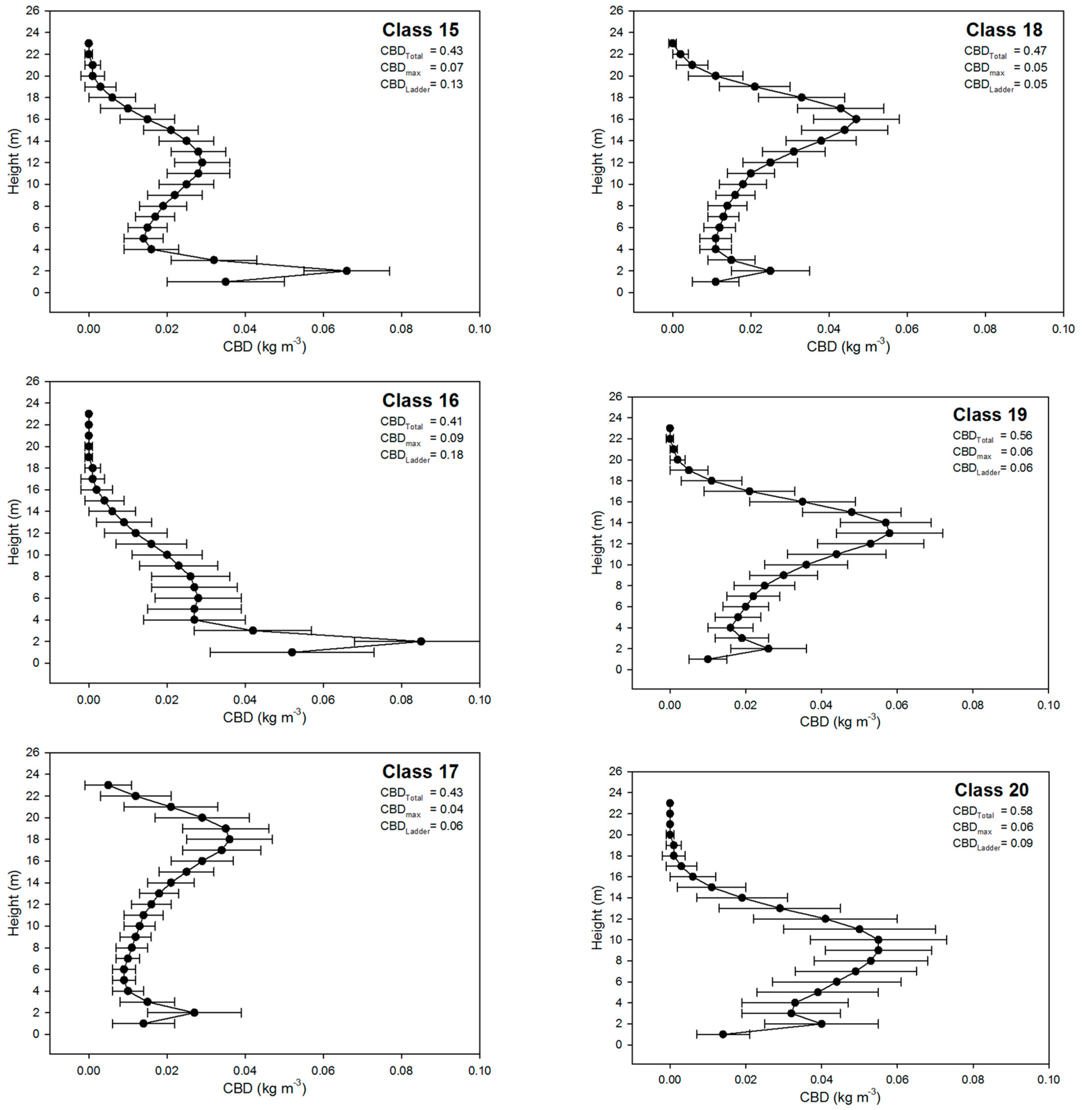
| CHP Class | CBDtotal (kg m−2) | CBDmax (kg m−3) | CBDladder (kg m−3) | Proportion of Pre-Fire Image (%) | Proportion of Post Fire Image (%) |
|---|---|---|---|---|---|
| Class 1 | 0.03 | 0.01 | 0.02 | 0 | 2 |
| Class 2 | 0.14 | 0.02 | 0.03 | 0 | 18* |
| Class 3 | 0.22 | 0.02 | 0.04 | 1 | 13* |
| Class 4 | 0.16 | 0.06 | 0.12 | 1 | 0 |
| Class 5 | 0.22 | 0.05 | 0.12 | 3 | 1 |
| Class 6 | 0.25 | 0.04 | 0.07 | 2 | 2 |
| Class 7 | 0.26 | 0.03 | 0.06 | 10* | 5 |
| Class 8 | 0.27 | 0.03 | 0.05 | 4 | 10* |
| Class 9 | 0.30 | 0.04 | 0.05 | 3 | 8 |
| Class 10 | 0.29 | 0.03 | 0.04 | 4 | 11* |
| Class 11 | 0.30 | 0.03 | 0.03 | 1 | 11* |
| Class 12 | 0.40 | 0.04 | 0.08 | 4 | 4 |
| Class 13 | 0.34 | 0.05 | 0.10 | 2 | 3 |
| Class 14 | 0.40 | 0.04 | 0.08 | 4 | 5 |
| Class 15 | 0.43 | 0.07 | 0.13 | 2 | 2 |
| Class 16 | 0.41 | 0.09 | 0.18 | 9 | 1 |
| Class 17 | 0.43 | 0.04 | 0.06 | 7 | 1 |
| Class 18 | 0.47 | 0.05 | 0.05 | 14* | 2 |
| Class 19 | 0.56 | 0.06 | 0.06 | 9 | 1 |
| Class 20 | 0.58 | 0.06 | 0.09 | 21* | 0 |
| Model | AIC | R2 |
|---|---|---|
| Fuels | 2,610,105 | 0.37 |
| Fuels + Shape | 2,595,323 | 0.42 |
| Fuels + Shape + Firing | 2,517,345 | 0.61 |
| Variable Set | Variable | β* | SE | P |
|---|---|---|---|---|
| Fuels | ||||
| b5 | 0.09 | 78.39 | <0.001 | |
| b6 | −0.05 | 68.26 | <0.001 | |
| b13 | −0.04 | 83.51 | <0.001 | |
| CBDcanopy | 0.13 | 18.04 | <0.001 | |
| CBDmid: CBDcanopy | 0.50 | 3.33 | <0.001 | |
| Canopy shape | ||||
| Class 1 | −0.05 | 12.27 | <0.001 | |
| Class 2 | −0.23 | 9.64 | <0.001 | |
| Class 3 | −0.04 | 5.67 | <0.001 | |
| Class 4 | −0.12 | 7.02 | <0.001 | |
| Class 7 | −0.01 | 4.30 | NS | |
| Class 8 | −0.01 | 4.35 | NS | |
| Class 9 | 0.01 | 4.23 | <0.001 | |
| Class 10 | 0.02 | 4.47 | <0.001 | |
| Class 12 | 0.22 | 9.05 | <0.001 | |
| Class 13 | −0.05 | 5.07 | <0.001 | |
| Class 14 | 0.08 | 6.23 | <0.001 | |
| Class 15 | −0.06 | 4.77 | <0.001 | |
| Class 16 | −0.17 | 4.75 | <0.001 | |
| Class 17 | −0.01 | 4.12 | <0.001 | |
| Class 18 | −0.02 | 2.91 | <0.001 | |
| Class 19 | −0.01 | 3.96 | NS | |
| Class 20 | −0.01 | 3.97 | NS | |
| Firing | ||||
| Backing fire | −0.34 | 0.99 | <0.001 | |
| Heading fire | 0.24 | 0.56 | <0.001 | |
| Burn Severity Class | Change in CBDtotal (kg m−3) | Change in CBDmax (kg m−3) | Change in CBDladder (kg m−3) |
|---|---|---|---|
| 1 | 0.076 | 0.008 | 0.006 |
| 2 | −0.141 | −0.015 | −0.012 |
| 3 | -0.187 | −0.021 | −0.016 |
| 4 | −0.204 | −0.024 | −0.036 |
| 5 | −0.258 | −0.039 | −0.072 |
| 6 | −0.304 | −0.038 | −0.304 |
| Severity 1 | Severity 2 | Severity 3 | Severity 4 | Severity 5 | Severity 6 | ||
|---|---|---|---|---|---|---|---|
| Mean patch size (ha) | Pre | 0.03 ± 0.05 | 0.06 ± 0.23 | 0.06 ± 0.26 | 0.06 ± 0.24 | 0.05 ± 0.21 | 0.15 ± 0.88 |
| Post | 0.03 ± 0.05 | 0.06 ± 0.19 | 0.08 ± 0.32 | 0.08 ± 0.25 | 0.07 ± 0.27 | 0.41 ± 2.60 | |
| Delta | 0% | 0% | 33% | 33% | 40% | 170% | |
| Sum of Patch Area (ha) | 41.4 | 287.6 | 360.2 | 189.0 | 77.0 | 132.3 | |
| Patch Density (patches/ha) | Pre | 36.5 | 16.3 | 15.8 | 15.7 | 18.6 | 6.3 |
| Post | 33.1 | 14.5 | 11.3 | 12.9 | 14.0 | 2.5 | |
| Delta | −9% | −11% | −28% | −18% | −25% | −60% | |
| Simpson’s Diversity Index | Pre | 0.91 | 0.84 | 0.83 | 0.77 | 0.76 | 0.68 |
| Post | 0.91 | 0.91 | 0.86 | 0.82 | 0.61 | 0.29 |
© 2020 by the authors. Licensee MDPI, Basel, Switzerland. This article is an open access article distributed under the terms and conditions of the Creative Commons Attribution (CC BY) license (http://creativecommons.org/licenses/by/4.0/).
Share and Cite
Skowronski, N.S.; Gallagher, M.R.; Warner, T.A. Decomposing the Interactions between Fire Severity and Canopy Fuel Structure Using Multi-Temporal, Active, and Passive Remote Sensing Approaches. Fire 2020, 3, 7. https://doi.org/10.3390/fire3010007
Skowronski NS, Gallagher MR, Warner TA. Decomposing the Interactions between Fire Severity and Canopy Fuel Structure Using Multi-Temporal, Active, and Passive Remote Sensing Approaches. Fire. 2020; 3(1):7. https://doi.org/10.3390/fire3010007
Chicago/Turabian StyleSkowronski, Nicholas S., Michael R. Gallagher, and Timothy A. Warner. 2020. "Decomposing the Interactions between Fire Severity and Canopy Fuel Structure Using Multi-Temporal, Active, and Passive Remote Sensing Approaches" Fire 3, no. 1: 7. https://doi.org/10.3390/fire3010007
APA StyleSkowronski, N. S., Gallagher, M. R., & Warner, T. A. (2020). Decomposing the Interactions between Fire Severity and Canopy Fuel Structure Using Multi-Temporal, Active, and Passive Remote Sensing Approaches. Fire, 3(1), 7. https://doi.org/10.3390/fire3010007