Article

Century-Scale Fire Dynamics in a Savanna Ecosystem

by
Bérangère A. Leys
1,2,*,
Daniel Griffin
3,
Evan R. Larson
4 and
Kendra K. McLauchlan
1
1
Department of Geography, Kansas State University, Manhattan, KS 66506, USA
2
Université Bourgogne Franche-Comté, UMR 6249 Chrono-environnement, 16 route de Gray, F-25030 Besançon CEDEX, France
3
Department of Geography, Environment & Society, University of Minnesota, Minneapolis, MN 55455, USA
4
Department of Geography, University of Wisconsin-Platteville, WI 53818, USA
*
Author to whom correspondence should be addressed.
Submission received: 31 July 2019 / Revised: 25 August 2019 / Accepted: 6 September 2019 / Published: 17 September 2019

Abstract

:
(1) Background: Frequent fire, climate variability, and human activities collectively influence savanna ecosystems. The relative role of these three factors likely varies on interannual, decadal, and centennial timescales. Here, we tested if Euro-American activities uncoupled drought and fire frequencies relative to previous centuries in a temperate savanna site. (2) Methods: We combined records of fire frequency from tree ring fire scars and sediment charcoal abundance, and a record of fuel type based on charcoal particle morphometry to reconstruct centennial scale shifts in fire frequency and fuel sources in a savanna ecosystem. We also tested the climate influence on fire occurrence with an independently derived tree-ring reconstruction of drought. We contextualized these data with historical records of human activity. (3) Results: Tree fire scars revealed eight fire events from 1822–1924 CE, followed by localized suppression. Charcoal signals highlight 13 fire episodes from 1696–2001. Fire–climate coupling was not clearly evident both before and after Euro American settlement The dominant fuel source shifted from herbaceous to woody fuel during the early-mid 20th century. (4) Conclusions: Euro-American settlement and landscape fragmentation disrupted the pre-settlement fire regime (fire frequency and fuel sources). Our results highlight the potential for improved insight by synthesizing interpretation of multiple paleofire proxies, especially in fire regimes with mixed fuel sources.

1. Introduction

Fire and climate, together, are the main drivers of ecosystem structure and function over millennia [1,2]. Frequent fires are particularly important for grasslands, shrublands, and savannas, which represent 40% of terrestrial biomes [3]. Savannas are found at the climate-mediated interface between closed-canopy forests with multidecadal to centennial fire return intervals and grasslands with annual fire return intervals [4,5,6]. Subtle changes in fire frequency can lead to substantial changes in the structure and composition of vegetation communities with varying tree cover such as savannas [7], yet clarifying the relative and interactive roles of historical fire and climate variability in savanna dynamics has been difficult because of challenges in obtaining long records of fire activity through dendrochronology or charcoal particles preserved in sedimentary records [8,9].
The climate system affects ecosystem structure and function directly through variation in precipitation, temperature, soil moisture, and evaporation. Drought is a hydroclimate extreme that integrates these variables and constitutes a key type of disturbance affecting ecosystem dynamics and vegetation composition [10,11]. Drought variability modulates overall ecosystem productivity, influences the occurrence of other disturbances such as fire, and affects tree and herb demographic factors such as mortality, regeneration, and recruitment. The consequences of past and future droughts for ecosystem function are not fully understood [12], leaving a large source of uncertainty in predicting the ecosystem impacts of future climate change.
Drought can interact with fire regimes in two opposing ways [12,13]. In fuel-limited systems such as semi-arid grasslands, variations in soil moisture impact grass productivity [14], which in turn influences the spread of fires [15]. However, droughts can also increase the flammability of woody fuels and increase fire frequency or intensity [16]. Discerning these possibilities is important for accurate prediction of how terrestrial biomes will respond to future climate change, but requires long-term records of fire occurrence, fuel sources and climate characteristics. In a savanna ecosystem where tree cover varies in both space and time, and, with it, the functional dynamics of the system, it is crucial to understand ecological responses to both drought and fire regime. One of the few studies to address long-term changes in grassland fire behavior, in an African savanna, demonstrated fuel limitation during dry conditions in the late Holocene [17] and a dominance of herbaceous fuel interpreted as low-severity understory fires.
In addition to climate conditions, human activities must be considered when reconstructing long-term fire dynamics [18,19,20,21]. Much progress has been made on separating the effects of climatic and human drivers on fire activity at spatial scales ranging from the site (i.e., [18]) to the globe [22]. Euro-American settlement of North America has been demonstrated to both increase [23] and decrease [24] fire frequency in forests. In the north-central U.S., widespread settlement started in the 1800s CE and involved conversion of native savanna and grassland habitat to agricultural production. Around the same time, shifting perspectives on the use of fire in land management caused a pronounced transition to widespread fire exclusion and suppression at landscape to regional scales (i.e., there have been relatively few and relatively small wildfire events in the past 100 years). Little to no direct evidence of the timing and nature of this shift exists because of the anecdotal character of most written records [25] on the subject and the paucity of quantitative fire histories at the prairie–forest border and in temperate savanna ecosystems [26]. In addition to changes in fire frequency, humans may have caused changes to other aspects of fire regime such as a reduction in intensity or a change in seasonality of fire events [27]. In much of the upper Midwest, it is likely that both lightning-caused fire and burning by Native Americans played a large role in forest processes during the pre-Euro-American period [28]. In particular, strong evidence exists for human-augmented fire frequency in certain coniferous forests found in the northern parts of the region [29,30]. The understanding of human influences on fire regimes in the more southern vegetation communities of the region remain relatively poorly understood due to a lack of relevant historic or paleoecological data [28,31].
Here, we reconstructed both tree-ring and charcoal-based records of fire history within the prairie–forest border in the upper Midwestern U.S. (Minnesota) to assess the feasibility of integrating proxies and to develop a unique perspective on changes in fuel sources and fire regime characteristics in this temperate savanna ecosystem over recent centuries. Modern perspectives of the land and vegetation communities suggest substantial changes have occurred in the structure, composition, and functional proprieties of the savanna ecosystem. Deciphering the relative roles of human impacts and climate on savanna ecosystem fire regimes is important to better frame potential responses of this ecosystem to future changes, and to manage this ecosystem accordingly. Our central inspiration for this work was twofold: (i) How can tree-ring and sediment proxies be integrated to provide a more complete understanding of past fire regimes than either could alone? (ii) How can a multi-proxy perspective help determine how humans and climate influenced the fire regime of a temperate savanna over recent centuries? Within these larger questions, we hypothesized that:
(1) Drought was historically an important driver of fire in our study area. Because our study area was located within a landscape matrix of prairie and savanna, we expected that extended dry conditions would have led to a greater dominance of herbaceous plants, an increase in availability and dominance of fine fuels, and a higher frequency of lower intensity fire during in the early Holocene. Further, we expected drought and fire frequencies to become uncoupled because of Euro-American fire suppression.
(2) Fuel source, on the other hand, could have changed between woody and herbaceous because both fuel sources are present in savanna ecosystems. We expected that fine fuels were most dominant prior to settlement, and that coarse fuels became more common following fire suppression reported in the 1930s and subsequent woody plant encroachment.
(3) After Euro-American settlement, a reduction in fire frequencies is assumed to be due to fire suppression, until the onset of a prescribed burning program initiated in our study area in the 1960s which would increase fire frequencies in the immediate vicinity of our study area.

2. Materials and Methods
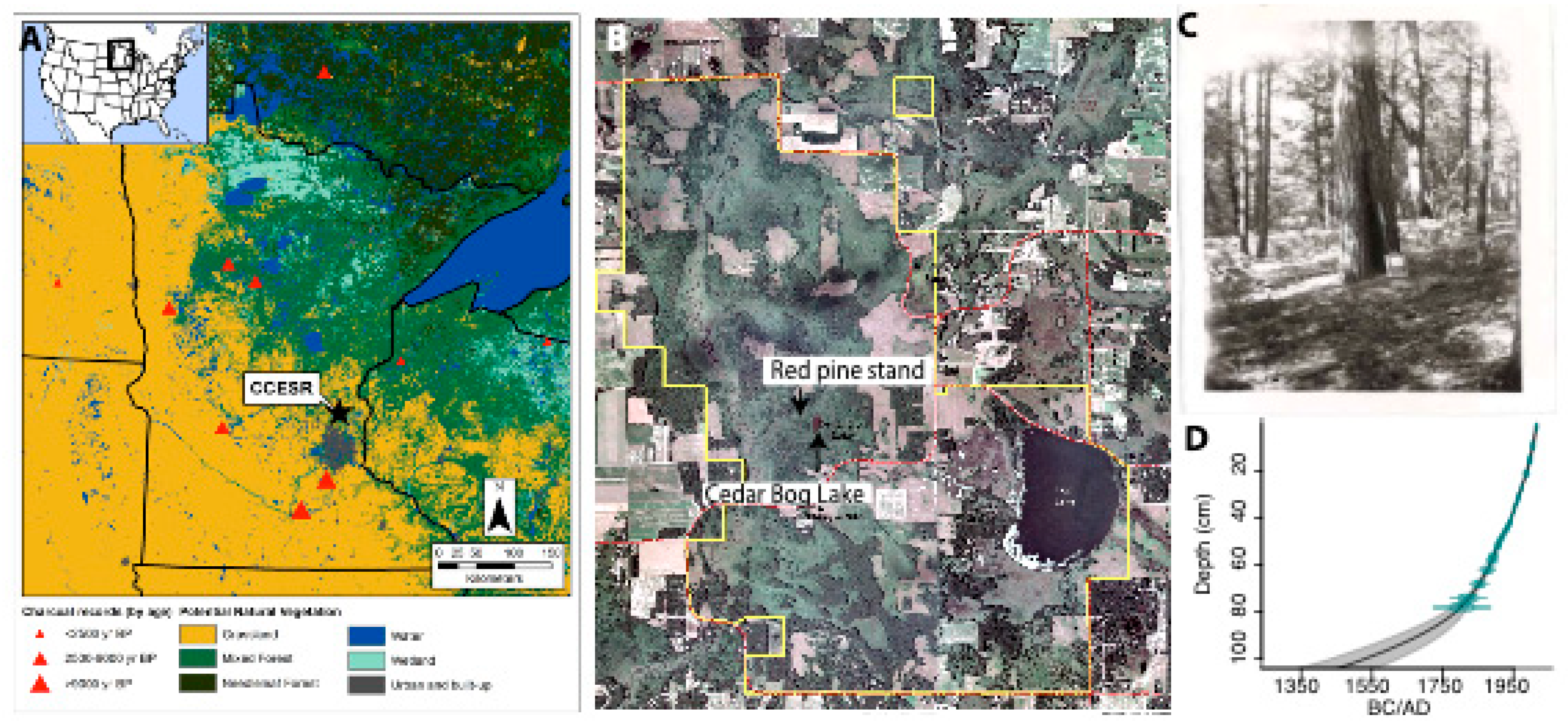
2.1. Site

Cedar Creek Ecosystem Science Reserve (hereafter CCESR) is a 22 km2 U.S. National Science Foundation-supported Long-Term Ecological Research (LTER) Site in east central Minnesota, U.S.A (Figure 1). CCESR lies between grassland and forested biomes in a savanna ecosystem. Current vegetation composition is a mosaic of prairie, oak, hardwood, and pine forests across the reserve. CCESR is located on the Anoka Sand Plain subsection of the Minnesota DNR Ecological Classification System, with flat to somewhat rolling terrain, a total relief of less than 10 m, and sandy soils derived from glacial outwash deposits [32].
We chose CCESR as our study site because of (1) the unique opportunity to pair both tree-ring and sediment-based fire reconstructions at the same location, (2) its location in the prairie-forest border, the vegetation of which is sensitive to both drought and fire conditions, (3) a lack of information about pre-settlement fire regimes of this area (Figure 1), and (4) the excellent historical records of the timing and nature of Euro-American land use and fire management in the reserve.
Our study sites within CCESR include Cedar Bog Lake, the lake sampled for the first ecosystem energy budget analysis performed to reveal food web functioning in ecological systems [33], and a nearby stand of pre-settlement red pine (Pinus resinosa) within the same watershed. The lake lies within an extensive area of bog forest and is likely the remnant of a larger body of water [34,35]. It is now a 1.5 ha shallow lake (1 to 3 m water depth) surrounded by a floating bog with northern white cedar (Thuja occidentalis), tamarack (Larix laricina), and black spruce (Picea mariana). The bog is bordered by stands of northern pin oak (Quercus ellipsoidalis) with an open canopy or as a dominant associated with white oak (Quercus alba), bur oak (Quercus macrocarpa), northern red oak (Quercus rubra), paper birch (Betula papyrifera), eastern white pine (Pinus strobus), red pine (Pinus resinosa), and jack pine (Pinus banksiana). Two isolated knolls dominated by Thuja-Larix swamp lie to the south and west of Cedar Bog Lake and support stands of Q. rubra (Figure 1). The stand of red pine analyzed in this study is approximately 300 m from the lake (Figure 1). Non-plantation stands of red pine are relatively rare in central Minnesota, which is the southwestern margin of the species’ native range. The stand of red pine was relatively small, at about 2 ha in area, and included only a few scattered large, fire-scarred mature pines among a denser cohort of younger trees growing on a relatively gentle southwest-facing slope.
An original and unpublished master’s thesis from Pierce [36] provided a wealth of information about land use history at the property, drawing on interpretation of past disturbance of historical aerial photos, soil and forest cover maps, and oral-history from interviews of nearby residents. Euro-American settlement of this region began as early as 1856 CE on a very limited scale. By the last decade of the 1800s, settlement was widespread. At 1900 CE, the first recorded impact of intensive land use activities (timber harvesting and agricultural fields) was based on pollen assemblages (increase of Ambrosia and decrease of arboreal pollen) in Cedar Bog Lake by Cushing [35]. From this date and up to 1930, Euro-Americans routinely set fire to wetlands and marshes early in the spring to improve hay production [36]. Fire suppression was the dominant policy from the 1930s until widespread crop failure and land abandonment in the 1940s enabled the University of Minnesota to acquire the property in 1952. A large-scale and systematic prescribed fire experiment was established in the 1960s and expanded to more burn units in the 1980s and 1990s. Across this burn experiment, fire was reintroduced to overgrown oak savannas, overgrown oak woodlands, and abandoned farm fields across a range of fire frequencies (0.1–1.0 fires per year) [37,38].

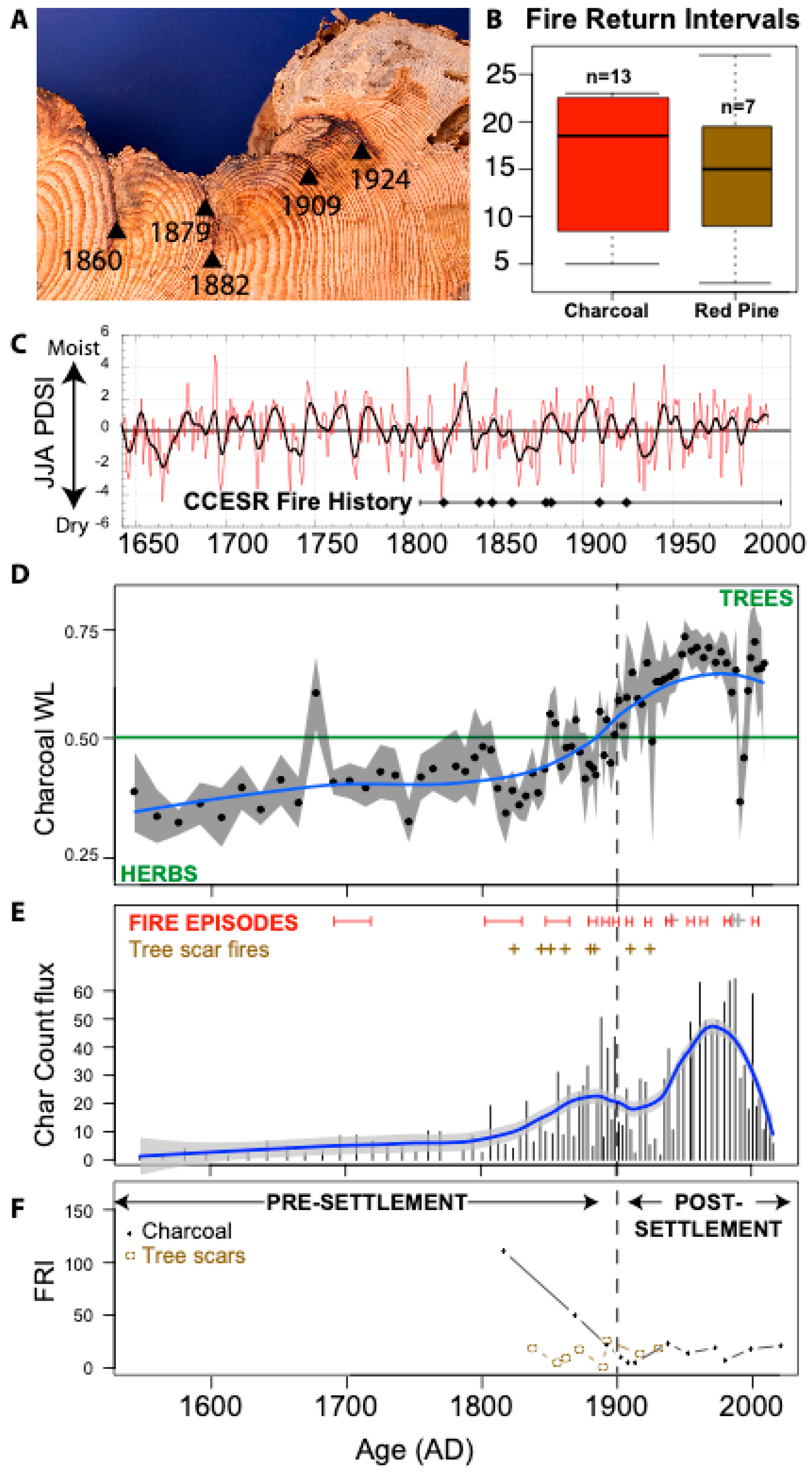
2.2. Fire Scar Analysis

A complete census of the red pine stand identified two large fire-scarred red pine trees within the stand. One of these trees was dead and sampled with a chainsaw (Figure 1), while multiple increment core samples were collected from the living fire-scarred tree to bracket fire dates. The uniqueness of these trees to CCESR is exemplified in that it was later realized that both trees were photographed by Pierce [31] as evidence of past surface fire activity at the reserve (Figure 1).
To crossdate the fire scar specimens and evaluate stand age structure, increment cores were collected along two or more radii of 60 living red pines within the stand. All tree-ring samples were air dried and sanded to a high polish using progressively finer sandpaper until individual xylem cells were visible under 3.5–40× magnification. A master ring-width chronology was developed from the increment core samples through visual crossdating and used to assign absolute calendar dates to the growth rings of the fire-scar sample. Fire scars in the cross section were assigned calendar dates and, when possible, intra-ring positions to identify the seasonality of each fire [39].

2.3. Sediment Core

During May 2016 CE, we extracted a short (101-cm) sediment core and a longer sediment core (15-m) from Cedar Bog Lake, Minnesota (45.410262° N, 93.199271° W) to develop a new charcoal-based reconstruction of fire history. The chronology for the sediment core was establishing using 210Pb dating at the St. Croix Watershed Research Station and five 14C dates from plant macroremains (seeds, needles and leaves) extracted from the sedimentary samples. An age-depth model was established from the 14C dates and calibrated with Intcal09 calibration curve for the northern hemisphere [40] and the 210Pb dates with a locally weighted scatterplot smoothing (LOWESS) regression that is robust to outliers using the clam software package in R [41] (Figure 1). The transition between the 210Pb and the 14C dates created an important change in the accumulation rate, thus we used 2-cm thick samples from the short core from 0 to 40 cm depth, and 1-cm thick samples from the first core of the longer core from 41 to 100 cm depth. This transition at 40 cm depth was chosen based on the overlap of charcoal concentration curves. This allowed us to (1) have the youngest part of the history from the short core, (2) avoid the first part of the longer core disturbed by extraction from the water, (3) maintain the same accumulation rate through time, and (4) reconstruct a more robust fire history.
Charcoal particles preserved in the sediment were used to reconstruct the past fire regimes in this area, particularly changes in biomass burning and fuel source through time. One cm3 of sediment was extracted every 2-cm for the first 20 cm and every cm for the rest of the core to homogenize the resolution time among samples. The sediments were sieved through a 60 µm mesh and we quantified sedimentary charcoal particles over 60 µm, which has been demonstrated to accurately reflect fuel sources in non-forested environments [42]. The width-to-length ratio (hereafter WL ratio) has been used to differentiate fuel sources, since grasses produce thinner and longer particles than woody vegetation [42,43], which is especially useful in the grass-savanna environment where low-intensity, high frequency fires are thought to have been common [44]. The width and length of each charcoal particle was measured using the image analysis software WinSeedle (Regular version 2016, Regent Inc. Instrument).
Local fire episodes were inferred from the macrocharcoal record using the decomposition approach, which separates charcoal peaks (CHARpeak), indicative of local fire episodes, and charcoal background (CHARbackground) component, that is indicative for regional area burned, following the method described by Higuera et al. [45]. To decompose the CHAR series, we separated the CHARbackground and CHARpeak components by fitting the data with a LOWESS regression, and identifying outstanding events as those that surpass the locally defined threshold type. Although we cannot rule out the possibility of charcoal pieces larger than 60 µm being transported longer distances [46], empirical studies indicate that peaks of CHAR are indicative of fire occurrence within a distance of 1.0–5.0 km from the lakeshore in grassland areas [8,44]. Fire events were grouped when two fire events were reconstructed from two consecutive samples. The ages of the reconstructed local fire episodes were used to calculate the fire-return interval (FRI; years between two consecutive fires, yr fire−1) (Figure 2).

2.4. Paleoclimate Data

To evaluate the relationships between the paleofire proxy records and climate, we extracted a timeseries from the North American Drought Atlas (NADA) [32] gridpoint nearest CCESR. This tree-ring-based drought reconstruction provides a precisely dated and annually resolved record of the Palmer Drought Severity Index for the June–August season. In this region, NADA data are tightly coupled and positively correlated with midsummer precipitation [47]. It is worth noting that while calibration and verification results indicate a skillful reconstruction, very few moisture sensitive tree-ring chronologies are currently available for Minnesota, and the NADA gridpoint 45.25ºN, −93.25ºE analyzed herein draws heavily on tree-ring data from across a 500–1500 km radius from the CCESR site (Figure 2). No CCESR data were included in the calculation of the NADA, so this is an independent paleoclimate record.

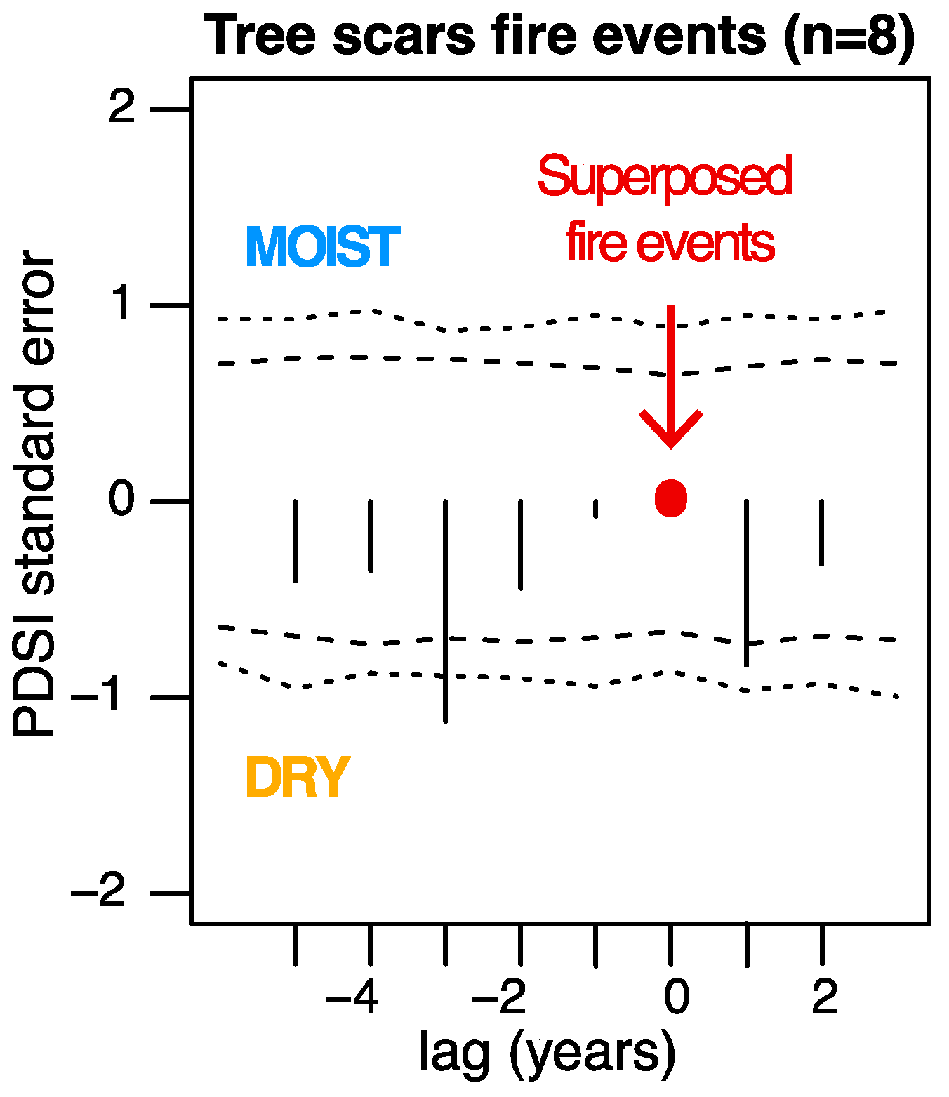
2.5. Statistical Tests

Fuel limitation was assessed following methods of Nelson et al. [17] that tested statistical correlations between regional moisture availability and charcoal abundance per unit of time with a Spearman correlation rank sum test (anticorrelation is producing negative rho values, correlation positive rho values and the absence of trends in the correlation is producing null value) and a test of significance with a p-value. Correlation between regional moisture and the charcoal WL ratio were used to assess the fuel type response to climatic conditions with a Spearman correlation rank sum test (function cor.test()) on R software version 3.4.3 (R Foundation for Statistical Computing, Vienna, Austria. URL https://www.R-project.org/) [48].
A change point analysis was performed on the mean and variance of the charcoal abundance over time using function cpt.meanvar() of the package changepoint of R software. This function is used to find changes in mean and variance for data using an exact multiple changepoints (Segment Neighbourhoods) method. To confirm that the change points revealed were not biased by the change of accumulation rate, or the age-depth model, a change point analysis was done on 100 random resamplings of charcoal influx paired on the same time period and resolution, following the method of W. Finsinger (available online on github.com/wfinsinger; last access 11 April 2019).
Superposed epoch analyses (SEA) were performed for retained fire events on the annually resolved regional moisture index (PDSI, [49]). For the tree scar-derived fire events, the SEA spans the period 1810–1935 CE, corresponding to the length from the oldest to the youngest tree scars (Figure 3). For the charcoal-derived fire episodes, SEA was performed on three different time periods. First, we considered all fire events from 1550 to 2016 CE, which corresponded to the sediment core length of record; second the period 1550 to 1900 CE, which corresponded to the pre-settlement period with herbaceous fuel as the main fuel source (as derived from the WL results described below); and third the period 1900 to 2006 CE, which corresponded to the post-settlement period and the woody fuel as the main fuel source (as derived from the WL results). To account for the fire dates uncertainties of the charcoal-derived fire event reconstruction, the output results of the SEA were discussed regarding the 10-year mean, maximum and minimum values [50], which represents the extend of the maximum date uncertainties.

3. Results and Discussion

3.1. Tree-Ring Evidence of Fire History and Climate Impact

Fire history data, based on the one cross section collected from the dead red pine and increment core samples from the living tree, were extremely sparse but collectively represent a census of fire-scarred trees within the site. The cross section spanned 1809 to 2010 CE and included eight crossdated fire dates (1822, 1842, 1849, 1860, 1879, 1882, 1909, 1924 CE) (Figure 2). Increment core samples from the living tree in the Pierce [31] photograph dated from 1839–2015 CE, contained three crossdated fire scar events also recorded in the cross section (1860, 1882, and 1924), and suggested several other scars that were not represented in the core samples. These samples were dated against a 206-year ring-width chronology based on measurements of 114 increment core samples from 51 living trees, including the living tree sampled for fire scars. The innermost ring for most of these cores ranged from 1898–1927 CE, with a subset of all cores that intersected pith or were estimated to be within five years dating to 1898–1916 CE. These age data suggest that the living tree population is largely an even aged cohort that recruited within the 27-year fire-free window from 1882–1909 CE and may be, in part, a result of human-caused fire suppression. The occurrence of fire scarring and a lack of other stumps in the stand make it unlikely that this stand had been logged, and no red pine clearcutting activities were reported for the area, though there are reports of widespread timber harvesting of white pine in the region [36].
The distribution of intervals between tree-ring recorded fire episodes provided a median of 15 years for the active burning period (1822–1924 CE). All fire scars recorded on the cross section occurred in the early growing season, indicating late spring or early summer fire timing. These data also strongly suggest that fire severity was low because the same trees survived at least eight fires, suggesting relatively low-temperature surface fires characteristic of open, pre-Euro-American pine forests. The stand-scale fire frequency identified at CCESR was comparable to the results of other crossdated fire histories in red pine stands conducted in the region [29,51,52], though it should be noted that with fire dates derived from only two trees this is the minimum estimate of fire activity and other fires may have burned through the stand but gone unrecorded in the tree-ring record. CCESR shared a number of fire dates in common with the nearest published records, including 1909, 1879, and 1849 CE, though none of these years are shared by more than two sites and few would be considered widespread fire years. Although the tree-ring fire history information is primarily based on only a single sample, the collective evidence from these data indicate an open forest maintained by relatively frequent fire events and tell the exceedingly rare but vital story of fire activity at the prairie-forest border of central North America [52].
Summer drought conditions over the past 150 years—as reconstructed for the North American Drought Atlas NADA [49,53]—showed consistent relationship with tree-scar fire events on the third year preceding the fire (Figure 3). Despite the significant results identified, several considerations are relevant for interpreting these results. First, a mechanistic link between drier conditions three years prior to fire events in a savanna system that, based on charcoal analysis, were primarily driven by fine fuels that can dry and burn over relatively short periods, is lacking. Second, with only two fire-scarred specimens it is likely that our record is not completely representative of the local fire history as light surface fires could have gone unrecorded or burned in a spatially patchy structure. Another strong possibility is that most fire events occurred in the months before or early in the growing season (i.e., April, May, June). The summer Palmer Drought Severity Index reconstructed by the NADA that corresponds to mid-summer precipitation in this region [47] and may therefore not capture the climate window relevant to the timing of the fire events we documented. Additionally, it is possible that the system in which these pine trees grew was dominated by fine fuels such as prairie grasses. Thus, short-term dry spells that occurred at temporal scales of days or weeks, a scale not captured by tree-ring reconstructions of drought, could have enabled fires to have burned at the site, especially given the broad and distant geographic area used to derive the reconstruction for this gridpoint that may not capture local drought conditions. Finally, boot-strapped confidence intervals cannot entirely overcome the sample depth of only eight fire events included in the SEA and these fire dates may simply not fully represent the fire-climate relationships of the prairie-forest border. These considerations could be addressed through additional sampling, but no other fire-scarred pre-settlement trees have been found within CCESR, and so our interpretations of interannual fire-climate relationships must therefore be cautious. Another potential explanation, however, is that climate was not an important driver of fire activity at the scale of this single stand, and that abundant human ignitions could have masked a discernable relationship between seasonal climate variability and fire [22].
The fire history as reconstructed with fire scars provided insight to our hypotheses. First, the lack of significant relationship between fire and drought conditions indicates that conditions conducive to burning did not require drought in this system and may have been linked with sufficient fuel production but not overly wet conditions. Furthermore, in contrast to many other fuel-limited systems where prior year moisture was required to develop fuels that led to fire events, at the scale of this one site it seems that the relatively mesic conditions found at the prairie-forest border are sufficient for fuel production in most years. Second, while the dendrochronological record does not provide direct evidence of fuel source, we infer that at least fine fuels must have been an important fuel type given the high frequency and low intensity of the fires that scarred the sampled red pine trees. Third, there was strong evidence of fire suppression after Euro-American settlement, but the beginning of prescribed burning in the 1960s was not seen in the fire scar record. This makes sense, given that this stand was not included in the controlled burn experiment area within CCESR.

3.2. Perspectives from Fire History in Sedimentary Charcoal

The charcoal-based fire history depicts 13 fire episodes from the charcoal signal, corresponding to the median years 1696, 1807, 1857, 1879, 1889, 1894, 1899, 1922, 1936, 1955, 1962, 1980, and 2001 CE plus or minus date uncertainties (Figure 2). Given the dating uncertainty, the fires recorded from charcoal influx in 1807 and 1857 CE are encompassing fire episodes from 1789 to 1864 CE, thus corresponding to the fires from tree scars at 1822, 1842, and 1849 CE (Figure 2). This is the same for the fire episode reconstructed from charcoal influx in 1879 CE, encompassing fires from tree scars in 1879 and 1882 CE. Finally, the fire episode at 1922 CE from charcoal falls within the window of dating uncertainty around the 1924 CE from tree scars. The only fire scar not identified from the charcoal influx is in 1909 CE possibly due to a very local fire event, such as the spring burning that was commonly applied to wetlands to improve hay yields during the last decades of the 19th century and the first decades of the 20th century [31]. Compared to the tree-ring fire dates, the charcoal-derived fire episodes are more integrative of different fire types in the area (low and high fire severity) and record fire events over a longer time scale and a larger area. However, the charcoal-derived fire history is less precise in the specific date of the events reconstructed, interpreted as episodes of fire given the time window encompassed in the 1- or 2cm thickness of sediments (1 to 5 years) and the inherent uncertainties in the sediment chronology (5 to 15 years). Both records are thus complementary, and allow an improved and more holistic interpretation of savanna fire regimes in this otherwise data-poor area.
Putting the fire history into a millennial perspective allows us to further test all three of our hypotheses. In the sedimentary record, the change point analysis reveals three distinct periods in the charcoal abundance dynamics: from 1550 to 1813 CE, from 1818 to 2001 CE, and from 2004 to 2016 CE. The size of charcoal particles we measured (60 µm) has been demonstrated to represent differences in both low-intensity fires with predominantly grassy or herbaceous fuels, and higher-intensity fires with woody fuels [44]. The number of charcoal particles was relatively low and constant from the start of the record until the early 1800s, then increased around 1820 CE, and displayed the largest values from 1920 to 1980 CE (Figure 2). Changes in charcoal abundance therefore coincide with distinct cultural changes at CCESR, including the beginning of the Euro-American settlement in the 1800s and the establishment of a prescribed fire program at CCESR in 1960 CE. Increased charcoal particles have been demonstrated to be related to an increase in the biomass burned and the area burned within 5 km around a site within a non-forested landscape [42,44], suggesting that the amount of biomass being burned at CCESR over the past two centuries, and particularly since the onset of the prescribed fire program, is unprecedented on millennial time scales.
Calculation of the mean fire return interval (MFI) showed more frequent fires from 1900 to 2000 CE (MFI = 17 ± 6 years) than any other period over the past five centuries (MFI prior to 1900 = 34 ± 41 years) (Figure 2). The increase in biomass burning at 1900 CE aligns with significant increases in the mean and quartile distributions of the WL ratio of the charcoal particles, indicating that fuel sources shifted from primarily herbaceous to primarily woody fuel sources [42]. This shift in fire regime occurred at the same time as the earliest recorded impacts of European settlement on regional vegetation assemblages [35] and includes the establishment of the controlled burn experiment, which began in 1964. One of the primary inspirations of the prescribed fire program was to reduce encroachment of woody plants into previously open prairie and oak opening habitats [54]. Re-introduction of fire appears to have increased the combustion of woody fuels as the savanna system is readjusting to increased frequency of fires, yet after nearly 60 years of burning the charcoal record indicates what is still a historically unique fire environment at CCESR. Together, the significant changes in charcoal abundance and W:L ratios over recent centuries, given what is at understood about changes in the vegetation and fire regime of the study area, suggests that the fire regime and fuel types burning prior to Euro-American settlement were extremely stable despite the study area being situated within an ecological transition zone. Collectively, this indicates a fundamental change that not just the abundance and shape of charcoal is unprecedented over the past 200 years, but so too is the variability of the system.
It is difficult to directly compare the relationships between fire events and moisture conditions with the charcoal-based fire history due to the supra-annual temporal resolution of the sediment record. However, we were able to test the degree of fuel limitation and we observed no significant correlation between moisture availability (PDSI from [49]) and charcoal abundance over time for the entire period recorded by the sedimentary charcoal, as well as for the pre- and post-settlement periods (Table 1). A similar lack of relationships was observed for the comparison between the moisture index and the WL ratio (Table 1), suggesting no significant correlations between the summer drought index and the type of fuel or the biomass burned at our study area. The summer drought index is possibly not the best predictor climate variable determining biomass burned, or the type of fuel, notably because the post-settlement part of the record is sensitive to human impacts, and fire policies applied in the study area. On the other hand, the lack of significant relationship between summer drought and fire occurrence at this site could reflect the mesic conditions of this region relative to other fuel-limited systems. The rapid encroachment of woody plants into formerly open prairies and savannas clearly illustrates that this region is conducive to supporting extensive tracts of closed canopy forest and that disturbance, likely fire, was fundamentally important in creating the vegetation patterns encountered by Euro-American settlers. Indeed, the transition from prairie to big woods vegetation communities that occurred over a few centuries shows the sensitivity of the vegetation in this region to subtle changes in environmental conditions [55,56]. Droughts severe enough to reduce fuels sufficiently to exclude fire may be rare events, while short periods of weather conducive to spring and fall burning undoubtedly occur much more frequently. The combined effects of these dynamics do not necessarily indicate climate is an unimportant driver of fire activity here, but that multiple factors may reduce the relative importance of climate at a local scale. Additional high-resolution charcoal records across the prairie-forest border could utilize scale to better identify the role of climate in the fire regimes of this region.
The Superposed Epoch Analysis (SEA, Table 1) on fire episodes derived from charcoal abundance in response to pre- and post-settlement climatic conditions allows a slightly different test of our first hypothesis about the relationship between fire events and drought conditions. The results of the SEA are described considering the average climatic conditions in the ten years before and after fire episodes of the three distinct periods. In the SEA analysis, the fire events present no significant relationship with moisture conditions (Table 1). however, the mean fire return interval of 17 years could indicate the importance of generally dry conditions conducive to fire ignition and spread [17]. As described above, the region represented in the climate reconstruction (NADA) covers a larger area than our study area. The fuel type in the pre-settlement period is dominated by herbs, likely indicating a mix of fires burning through open grasslands or spreading in the understory of a savanna landscape with scattered trees and abundant fine fuels [8]. The second scenario seems to be the most accurate given the pollen reconstruction from Cushing (1963) suggesting an oak-savanna ecosystem with a relatively low amount of pines and because that matches the dendrochronological evidence that pre-settlement fires were relatively low intensity and left the red pine trees alive.
Overall, the sedimentary fire record provides some, but not complete, support of our three hypotheses. First, it appears that drought and fire episodes were uncoupled. However, in contrast to our expectations, the interplay of wet and dry conditions may have had important roles in the overall fire prone conditions leading to recurrent fires over the past 300 years. Second, the fuel source reconstructions throughout the century-scale sedimentary record do indicate a large shift toward more woody fuels in the late 19th century, which reflects the change of fire regime (intensity, fuel type, and biomass burned) possibly due to nearby homestead settlement activities and fire policies associated with Euro-American settlement. Third, the sedimentary charcoal record did not indicate fire suppression or a reduction in fire frequencies after Euro-American settlement, but rather showed an increase in charcoal production and biomass burning throughout the 1900s with a marked increase in the mid-1900s coincident with the establishment of the controlled burn experiment at CCESR. This is important, given that most of the modern landscape around CCESR is used in agricultural production and the presence of fire as an ecological process is negligible. Clearly, the charcoal record in Cedar Bog Lake is dominated by relatively local fire activity.

3.3. Synthesis of Fire History, Human Activities, and Climate Impact

The integration of fire scar and charcoal records illustrate fundamental drivers, long-term patterns, and profound changes in the fire regime of our study area. The general lack of summer drought, as represented in the NADA, as a driver of fire indicates a more subtle and variable role of climate in driving interannual variability in fire activity for the temperate savanna ecosystem of Minnesota. This is an important contribution to a longstanding debate on what factors led to vegetation changes in the region, such as the rise of the Big Woods vegetation type in the 1300–1400 CE [57,58]. This result also aligns with recent work documenting “hybrid” fire systems that represent a mixture of fuel- and climate-limited fire regimes [59]. The influence of people on the fire regime and vegetation of this region, has clearly been important. The specific role of Native American activities on fires in this region is difficult to determine from our records, especially when the tree-ring data only pre-date Euro-American settlement by a few decades, but the dramatic increase in sedimentary charcoal influx in the early 1800s aligns with a time of cultural transition with the first settlement of Euro-Americans in the region (1856 CE in the region according to Pierce [36]), and also possibly reflecting the activities and interactions of the Anishinaabe and Lakota people who occupied this area prior to European arrival [60], and who were noted by Pierce to have fought a battle near CCESR in 1857 CE.
What is clear, however, is that surface fires dominated this system prior to Euro-American settlement, as illustrated on a site-scale by the fire scar and corroborated at the landscape scale by the charcoal record, and that the cessation of surface fires did occur over much of the study area in the early 1900s when intensive Euro-American land use activities were first recorded (timber harvesting and agricultural fields). Pollen records from previous research at Cedar Bog Lake indicated a significant increase in Ambrosia and decrease of arboreal pollen around 1900 CE [35], and coincides with Euro-American practices of routinely setting surface fires to wetlands and marshes early in the spring to improve the haying conditions, up to 1930 [36]. This date matches the onset of change in fuel types in the charcoal records from herbaceous to woody fuel sources. In addition, the tree-based fire history revealed no change of the fire season (late spring–early summer) between the first settler activities and the management of the LTER starting in the 1900s. However, further investigations are needed to determine if a change of fire season appeared between Native American and Euro-American practices, as it has been demonstrated in the Great Plains with a shift from the summer to the spring fire season, causing a decrease of vegetation diversity [27].
There is no period in the sedimentary record that demonstrates a 20th century reduction of fire activity, or fire suppression, as seen in the red pine fire scar record from 1925 CE to present. However, starting around 1990 CE, there is a decrease of the charcoal abundance in the sediment, with the last fire event reconstructed in 2001 CE (from 60 pieces per year to about 10 pieces of charcoal per year). Moreover, there is a dramatic change in fuel type around 1900 CE. In savanna systems where mixed fuels are common, the role of shifting fire intensity as well as shifting land cover could plausibly lead to this result on decadal to centurial timescales. We conclude that the charcoal WL ratio is providing a different source of information about fire activity in this region than the fire scars, and the number of charcoal particles.

4. Conclusions

The charcoal and tree-ring records we report here provide an opportunity to examine the different records produced as a result of the spatial and temporal scale of fire signals recorded by these proxies. The charcoal record is clearly recording landscape-scale production of charcoal from fires of all types, while the tree-ring data document highly localized, low intensity surface fires in more forested areas. This emphasizes the complementary nature of these two proxies for both better understanding past patterns of fire activity, and the uncertainty therein. There are several consistencies between the records, however, particularly the decrease of the area burned (decrease of the charcoal abundance per time unit [42]) and the decrease of the fire activity recorded from the scars in the 21th century. Despite 60 years of prescribed fire experiments at CCESR the current fire environment is unique relative to the past 500 years. While further data from additional sites in the region would help strengthen this evidence, this multiproxy approach demonstrates the nature of Euro-American fire regime changes in the prairie–forest border of central North America for this time period to our knowledge.

Author Contributions

Conceptualization, B.A.L. and K.K.M.; Data curation, B.A.L., D.G., E.R.L. and K.K.M.; Formal analysis, B.A.L.; Funding acquisition, K.K.M. and D.G.; Methodology, B.A.L., D.G. and E.R.L.; Project administration, K.K.M.; Supervision, D.G. and K.K.M.; Writing—original draft, K.K.M.; Writing—review & editing, B.A.L., D.G., E.R.L. and K.K.M.

Funding

This research was funded by NSF-DEB-1145815 to K.K.M., NSF-DEB-1655148 to K.K.M. and NSF-DEB- 1655144 to D.G.

Acknowledgments

We thank Cedar Creek Ecosystem Science Reserve for permission to conduct field work. Dan Engstrom directed the collection of the short sediment core and provided the 210Pb analysis. Members of the Novus III workshop assisted with sample collection. Jakob Hanschu provided charcoal data. Margaret Bialecki assisted in preparation, dating, and analysis of wood samples. We are grateful to the editor, and several anonymous reviewers whose suggestions led to an improved manuscript.

Conflicts of Interest

The authors declare no conflict of interest.

References

  1. Bond, W.J.; Woodward, F.I.; Midgley, G.F. The Global Distribtuion of Ecosystems in a world without Fire. New Phytol. 2005, 165, 525–538. [Google Scholar] [CrossRef] [PubMed]
  2. Bowman, D.M.J.S.; Balch, J.K.; Artaxo, P.; Bond, W.J.; Carlson, J.M.; Cochrane, M.A.; D’Antonio, C.M.; DeFries, R.S.; Doyle, J.C.; Harrison, S.P. Fire in the Earth system. Science (80) 2009, 324, 481–484. [Google Scholar] [CrossRef] [PubMed]
  3. White, R.P.; Murray, S.; Rohweder, M.; Prince, S.D.; Thompson, K.M.J. Grassland Ecosystems; World Resources Institute: Washington, DC, USA, 2000; ISBN 1569734615. [Google Scholar]
  4. Gleason, H.A. The relation of forest distribution and prairie fires in the middle west. Torreya 1913, 13, 173–181. [Google Scholar]
  5. Lehmann, C.E.R.; Anderson, T.M.; Sankaran, M.; Higgins, S.I.; Archibald, S.; Hoffmann, W.A.; Hanan, N.P.; Williams, R.J.; Fensham, R.J.; Felfili, J.; et al. Savanna vegetation-fire-climate relationships differ among continents. Science (80) 2014, 343, 548–552. [Google Scholar] [CrossRef]
  6. Whelan, R.J. The Ecology of Fire; Cambridge University Press: Cambridge, UK, 1995; ISBN 0521328721. [Google Scholar]
  7. Briggs, J.M.; Knapp, A.K.; Brock, B.L. Expansion of Woody Plants in Tallgrass Prairie: A Fifteen-year Study of Fire and Fire-grazing Interactions. Am. Midl. Nat. 2002, 147, 287–294. [Google Scholar] [CrossRef]
  8. Aleman, J.C.; Blarquez, O.; Bentaleb, I.; Bonté, P.; Brossier, B.; Carcaillet, C.; Gond, V.; Gourlet-Fleury, S.; Kpolita, A.; Lefèvre, I. Tracking land-cover changes with sedimentary charcoal in the Afrotropics. Holocene 2013, 23, 1853–1862. [Google Scholar] [CrossRef]
  9. Leys, B.; Marlon, J.R.; Umbanhowar, C.; Vannière, B. Global fire history of grassland biomes. Ecol. Evol. 2018, 8, 8831–8852. [Google Scholar] [CrossRef] [PubMed] [Green Version]
  10. Allen, C.D.; Breshears, D.D.; McDowell, N.G. On underestimation of global vulnerability to tree mortality and forest die-off from hotter drought in the Anthropocene. Ecosphere 2015, 6, 1–55. [Google Scholar] [CrossRef]
  11. Anderegg, W.R.L.; Schwalm, C.; Biondi, F.; Camarero, J.J.; Koch, G.; Litvak, M.; Ogle, K.; Shaw, J.D.; Shevliakova, E.; Williams, A.P.; et al. Pervasive drought legacies in forest ecosystems and their implications for carbon cycle models. Science (80) 2015, 349, 528–532. [Google Scholar] [CrossRef] [Green Version]
  12. Schlesinger, W.H.; Dietze, M.C.; Jackson, R.B.; Phillips, R.P.; Rhoades, C.C.; Rustad, L.E.; Vose, J.M. Forest biogeochemistry in response to drought. Glob. Chang. Biol. 2015, 22, 2318–2328. [Google Scholar] [CrossRef]
  13. Krawchuk, M.A.; Moritz, M.A.; Parisien, M.-A.; Van Dorn, J.; Hayhoe, K. Global Pyrogeography: The Current and Future Distribution of Wildfire. PLoS ONE 2009, 4, e5102. [Google Scholar] [CrossRef] [PubMed]
  14. Knapp, A.K.; Smith, M.D. Variation among biomes in temporal dynamics of aboveground primary production. Science (80) 2001, 291, 481–484. [Google Scholar] [CrossRef] [PubMed]
  15. Swetnam, T.W.; Betancourt, J.L. Fire-southern oscillation relations in the southwestern United States. Science (Washington) 1990, 249, 1017–1020. [Google Scholar] [CrossRef] [PubMed]
  16. Williams, J.J.; McLauchlan, K.K.; Mueller, J.R.; Mellicant, E.M.; Myrbo, A.E.; Lascu, I. Ecosystem development following deglaciation: A new sedimentary record from Devils Lake, Wisconsin, USA. Quat. Sci. Rev. 2015, 125, 131–143. [Google Scholar] [CrossRef] [Green Version]
  17. Nelson, D.M.; Verschuren, D.; Urban, M.A.; Hu, F.S. Long-term variability and rainfall control of savanna fire regimes in equatorial East Africa. Glob. Chang. Biol. 2012, 18, 3160–3170. [Google Scholar] [CrossRef] [PubMed]
  18. Leys, B.; Carcaillet, C. Subalpine fires in the Alps for the past 8000 years: The roles of vegetation, climate and, untimely, land uses. Clim. Chang. 2016, 135, 683–697. [Google Scholar] [CrossRef]
  19. Dubinin, M.; Luschekina, A.; Radeloff, V.C. Climate, Livestock, and Vegetation: What Drives Fire Increase in the Arid Ecosystems of Southern Russia? Ecosystems 2011, 14, 547–562. [Google Scholar] [CrossRef]
  20. Sheuyange, A.; Oba, G.; Weladji, R.B. Effects of anthropogenic fire history on savanna vegetation in northeastern Namibia. J. Environ. Manag. 2005, 75, 189–198. [Google Scholar] [CrossRef] [PubMed]
  21. Behling, H.; Pillar, V.D.; Orlóci, L.; Bauermann, S.G. Late Quaternary Araucaria forest, grassland (Campos), fire and climate dynamics, studied by high-resolution pollen, charcoal and multivariate analysis of the Cambará do Sul core in southern Brazil. Palaeogeogr. Palaeoclimatol. Palaeoecol. 2004, 203, 277–297. [Google Scholar] [CrossRef]
  22. Bowman, D.M.J.S.; Balch, J.; Artaxo, P.; Bond, W.J.; Cochrane, M.A.; D’Antonio, C.M.; Defries, R.; Johnston, F.H.; Keeley, J.E.; Krawchuk, M.A.; et al. The human dimension of fire regimes on Earth. J. Biogeogr. 2011, 38, 2223–2236. [Google Scholar] [CrossRef] [Green Version]
  23. Foster, D.R.; Aber, J.D. Forests in Time: The Environmental Consequences of 1000 Years of Change in New England; Yale University Press: NewHaven, CT, USA, 2006; ISBN 0300115377. [Google Scholar]
  24. Marlon, J.R.; Bartlein, P.J.; Gavin, D.G.; Long, C.J.; Anderson, R.S.; Briles, C.E.; Brown, K.J.; Colombaroli, D.; Hallett, D.J.; Power, M.J.; et al. Long-term perspective on wildfires in the western USA. Proc. Natl. Acad. Sci. USA 2012, 109, E535–E543. [Google Scholar] [CrossRef] [Green Version]
  25. Vale, T.R. The Pre-European Landscape of the United States: Pristine or Humanized; Island Press: Washington, DC, USA, 2002. [Google Scholar]
  26. Nelson, D.M.; Hu, F.S.; Grimm, E.C.; Curry, B.B.; Slate, J.E.; Feng, S.H.; Grimm, E.C.; Curry, B.B.; Slate, J.E. The influence of aridity and fire on Holocene prairie communities in the eastern Prairie Peninsula. Ecology 2006, 87, 2523–2536. [Google Scholar] [CrossRef]
  27. Allen, M.S.; Palmer, M.W. Fire history of a prairie/forest boundary: More than 250 years of frequent fire in a North American tallgrass prairie. J. Veg. Sci. 2011, 22, 436–444. [Google Scholar] [CrossRef]
  28. Cardille, J.A.; Ventura, S.J.; Turner, M.G. Environmental and social factors influencing wildfires in the Upper Midwest, United States. Ecol. Appl. 2001, 11, 111–127. [Google Scholar] [CrossRef]
  29. Kipfmueller, K.F.; Schneider, E.A.; Weyenberg, S.A.; Johnson, L.B. Historical drivers of a frequent fire regime in the red pine forests of Voyageurs National Park, MN, USA. For. Ecol. Manag. 2017, 405, 31–43. [Google Scholar] [CrossRef]
  30. Muzika, R.M.; Guyette, R.P.; Stambaugh, M.C.; Marschall, J.M. Fire, drought, and humans in a heterogeneous Lake Superior landscape. J. Sustain. For. 2015, 34, 49–70. [Google Scholar] [CrossRef]
  31. Sturtevant, B.R.; Cleland, D.T. Human and biophysical factors influencing modern fire disturbance in northern Wisconsin. Int. J. Wildl. Fire 2007, 16, 398–413. [Google Scholar] [CrossRef] [Green Version]
  32. Aaseng, N.E.; Almendinger, J.C.; Dana, R.P.; Hanson, D.S.; Lee, M.D.; Rowe, E.R.; Rusterholz, K.A.; Wovcha, D.S. Minnesota’s native plant community classification: A statewide classification of terrestrial and wetland vegetation based on numerical analysis of plot data. Biol. Rep. 2011, 108, 1–27. [Google Scholar]
  33. Lindeman, R.L. The trophic-dynamic aspect of ecology. Ecology 1942, 23, 399–417. [Google Scholar] [CrossRef]
  34. Lindeman, R.L. The developmental history of Cedar Creek bog, Minnesota. Am. Midl. Nat. 1941, 25, 101–112. [Google Scholar] [CrossRef]
  35. Cushing, E.J. Late-Wisconsin Pollen Stratigraphy in East-Central Minnesota. Ph.D. Thesis, University of Minnesota, Minneapolis, MN, USA, 1963. [Google Scholar]
  36. Pierce, R.L. Vegetation Cover Types and Land Use History of the Cedar Creek Natural History Reservation, Anoka and Isanti counties, Minnesota. Master’s Thesis, University of Minnesota, Minneapolis, MN, USA, 1954. [Google Scholar]
  37. Peterson, D.W.; Reich, P.B. Prescribed fire in oak savanna: Fire frequency effects on stand structure and dynamics. Ecol. Appl. 2001, 11, 914–927. [Google Scholar] [CrossRef]
  38. Dijkstra, F.A.; Wrage, K.; Hobbie, S.E.; Reich, P.B. Tree patches show greater N losses but maintain higher soil N availability than grassland patches in a frequently burned oak savanna. Ecosystems 2006, 9, 441–452. [Google Scholar] [CrossRef]
  39. Baisan, C.H.; Swetnam, T.W. Fire history on a desert mountain range: Rincon Mountain Wilderness, Arizona, USA. Can. J. For. Res. 1990, 20, 1559–1569. [Google Scholar] [CrossRef]
  40. Manning, S.W. IntCal09 and Marine09 Radiocarbon Age Calibration Curves, 0-50,000 Years cal BP PJ Reimer, MGL Baillie, E Bard, A Bayliss, JW Beck, PG Blackwell, C Bronk Ramsey, CE Buck, GS Burr, RL Edwards, M Friedrich, PM Grootes, TP Guilderson, I Hajdas, TJ Heaton, AG. Radiocarbon 2009, 51, 1111–1150. [Google Scholar]
  41. Blaauw, M.; Heegaard, E. Estimation of Age-Depth RelationshipsTracking Environmental Change Using Lake Sediments; Birks, H.J.B., Lotter, A.F., Juggins, S., Smol, J.P., Eds.; Springer Science and Business Media: Utrecht, The Netherlands, 2012; Volume 5, pp. 379–413. ISBN 978-94-007-2745-8. [Google Scholar]
  42. Leys, B.; Commerford, J.L.; McLauchlan, K.K. Reconstructing grassland fire history using sedimentary charcoal: Considering count, size and shape. PLoS ONE 2017, 12, e0176445. [Google Scholar] [CrossRef]
  43. Umbanhowar, C.E.; Mcgrath, M.J. Experimental production and analysis of microscopic charcoal from wood, leaves and grasses. Holocene 1998, 8, 341–346. [Google Scholar] [CrossRef]
  44. Leys, B.; Brewer, S.C.; McConaghy, S.; Mueller, J.; McLauchlan, K.K. Fire history reconstruction in grassland ecosystems: Amount of charcoal reflects local area burned. Environ. Res. Lett. 2015, 10, 114009. [Google Scholar] [CrossRef]
  45. Higuera, P.E.; Brubaker, L.B.; Anderson, P.M.; Brown, T.A.; Kennedy, A.T.; Hu, F.S. Frequent fires in ancient shrub tundra: Implications of paleorecords for Arctic environmental change. PLoS ONE 2008, 3, e0001744. [Google Scholar] [CrossRef]
  46. Tinner, W.; Hofstetter, S.; Zeugin, F.; Conedera, M.; Wohlgemuth, T.; Zimmermann, L.; Zweifel, R. Long-distance transport of macroscopic charcoal by an intensive crown fire in the Swiss Alps-implications for fire history reconstruction. Holocene 2006, 16, 287–292. [Google Scholar] [CrossRef]
  47. George, S.S.; Meko, D.M.; Cook, E.R. The seasonality of precipitation signals embedded within the North American Drought Atlas. Holocene 2010, 20, 983–988. [Google Scholar] [CrossRef]
  48. R Core Team. R: A Language and Environment for Statistical Computing, R Foundation for Statistical Computing, Austria, 2015. 2018. Available online: r-project.org (accessed on 11 September 2019).
  49. Cook, E.R.; Seager, R.; Cane, M.A.; Stahle, D.W. North American drought: Reconstructions, causes, and consequences. Earth-Sci. Rev. 2007, 81, 93–134. [Google Scholar] [CrossRef]
  50. Cook, E.R.; Peters, K. The smoothing spline: A new approach to standardizing forest interior tree-ring width series for dendroclimatic studies. Bibliogr. Inf. 1981, 41, 45–53. [Google Scholar]
  51. Johnson, L.B.; Kipfmueller, K.F. A fire history derived from Pinus resinosa Ait. for the Islands of Eastern Lac La Croix, Minnesota, USA. Ecol. Appl. 2016, 26, 1030–1046. [Google Scholar] [CrossRef] [PubMed]
  52. Larson, E.R.; Green, M.A. Fire History at the Confluence of the Driftless Area and Central Sand Plains of Wisconsin: A Case Study from Castle Mound Pine Forest State Natural Area. Nat. Areas J. 2017, 37, 309–322. [Google Scholar] [CrossRef]
  53. Cook, E.R.; Meko, D.M.; Stahle, D.W.; Cleaveland, M.K. Drought Reconstructions for the Continental United States. J. Clim. 1999, 12, 1145–1162. [Google Scholar] [CrossRef]
  54. White, A.S. The effects of thirteen years of annual prescribed burning on a Quercus ellipsoidalis community in Minnesota. Ecology 1983, 64, 1081–1085. [Google Scholar] [CrossRef]
  55. Umbanhowar, C.E. Interaction of fire, climate and vegetation change at a large landscape scale in the Big Woods of Minnesota, USA. Holocene 2004, 14, 661–676. [Google Scholar] [CrossRef]
  56. Williams, J.W.; Shuman, B.; Bartlein, P.J. Rapid responses of the prairie-forest ecotone to early Holocene aridity in mid-continental North America. Glob. Planet. Chang. 2009, 66, 195–207. [Google Scholar] [CrossRef]
  57. Grimm, E.C. Fire and other factors controlling the Big Woods vegetation of Minnesota in the mid-nineteenth century. Ecol. Monogr. 1984, 54, 291–311. [Google Scholar] [CrossRef]
  58. Umbanhowar, C.E.; Camill, P.; Dorale, J.A. Regional heterogeneity and the effects of land use and climate on 20 lakes in the big woods region of Minnesota. J. Paleolimnol. 2011, 45, 151–166. [Google Scholar] [CrossRef]
  59. McKenzie, D.; Littell, J.S. Climate change and the eco-hydrology of fire: Will area burned increase in a warming western USA? Ecol. Appl. 2017, 27, 26–36. [Google Scholar] [CrossRef] [PubMed]
  60. Warren, W.W. History of the Ojibway People; Minnesota Historical Society: St. Paul, MN, USA, 2009; ISBN 0873516435. [Google Scholar]
Figure 1. (A) Location of sedimentary charcoal records in the upper Midwestern U.S. No sites are in the savanna biome and none have examined mixed fuel sources characteristic of savanna fire regimes. Source: Global Charcoal Database. (B) Aerial photography of Cedar Creek Ecosystem Reserve, with the red pine area and Cedar Bog Lake indicated. Red dashed lines are public rods and yellow line is CCESR boundary. (C) Photograph from 1954 of the red pine stand [31]; the tree in the foreground was living at the time of our sampling and cored, while the fire-scarred tree to the right and in the background was dead and sampled with a chainsaw. (D) Age-depth model for the Cedar Bog Lake short core based on 210Pb and 14C dates (not shown).
Fire 02 00051 g001
Figure 2. Fire history reconstructions. (A) Macrophotograph of growth rings from approximately 1852–2010 with fire scar events labeled. Each fire event occurred in the earlywood portion of the annual growth ring, suggesting late spring or early summer fires. (B) Box and whiskers plot illustrates distribution of intervals between tree-ring recorded fire episodes, with a median of 15 years for the active burning period (1822–1924 CE). Note that the recent 87-year hiatus in fire in the red pine stand (1925–2010 CE) is not included in this plot. (C) North American Drought Atlas tree-ring reconstructed Palmer Drought Severity Index (NADA PDSI) for southeastern Minnesota (NADA Gridpoint 45.25ºN, −93.25ºE), with a time series of fire events (diamonds) recorded by a by the tree illustrated above. (D) WL ratio of each particle summarized by boxplot per sample. (E) Charcoal influx (# particles cm−2 yr−1) with a smooth spline LOWESS robust to outliers to identified significant peaks (above the 95% confidence interval about the spline) from the background. Significant peaks are noted with red intervals accounting for the date uncertainties. For fire episodes identified in two consecutive samples, only one fire episode was retained (not retained fire episodes are grey crosses). (F) Fire return interval calculated as the number of years between two fires, derived from the fire event dates for the two methods.
Fire 02 00051 g002
Figure 3. Fire–climate relationships. Superposed Epoch Analysis of moisture conditions derived from NADA PDSI for gridpoint 45.25ºN, −93.25ºE (Cook et al. 2008, data available on ncdc.noaa.gov), with tree-ring-based fire events. The analysis was performed for the moisture condition 10 years before and after the fire events and bootstrapped 1000 times to calculate the confidence intervals at 95% (dashed lines) and 99% (dotted lines). All fire events correspond to the 8 fire events identified from the tree scars (1822, 1842, 1849, 1860, 1879, 1882, 1909, 1924 CE).
Fire 02 00051 g003
Table 1. Correlations between fire event years and moisture conditions at Cedar Creek. Spearman rank sum test correlations between charcoal count and WL ratio and PDSI values from the analyzed NADA gridpoint. Superposed Epoch Analysis (SEA) of PDSI values 10 year prior and after fire events reconstructed from charcoal peaks or tree scars. Three periods have been considered: (1) the entire charcoal or tree scars time extend, (2) pre-settlement period as defined by the period before 1900 AD, and (3) post-settlement period as defined by the period after 1900 AD.
Spearman correlationsXYPeriodrhop
Charcoal countPDSI1548–20040.180.1
1548–19000.070.7
1900–20040.070.6
Charcoal WL ratioPDSI1548–20040.060.6
1548–1900−0.090.5
1900–2004−0.010.9
Superposed Epoch AnalysisEventsPeriodmean95 CI99 CI
Charcoal-derived fires1548–20040.05−0.54 <.> 0.55−0.72 <.> 0.71
1548–1900−0.13−0.73 <.> 0.73−0.97 <.> 0.95
1900–20040.28−0.78 <.> 0.79−1.04 <.> 1.03
Tree scar-derived fires1822–1924−0.16−0.69 <.> 0.69−0.90 <.> 0.91

