Assessing the Influence of Roads on Fire Ignition: Does Land Cover Matter?


Abstract
1. Introduction
2. Materials and Methods
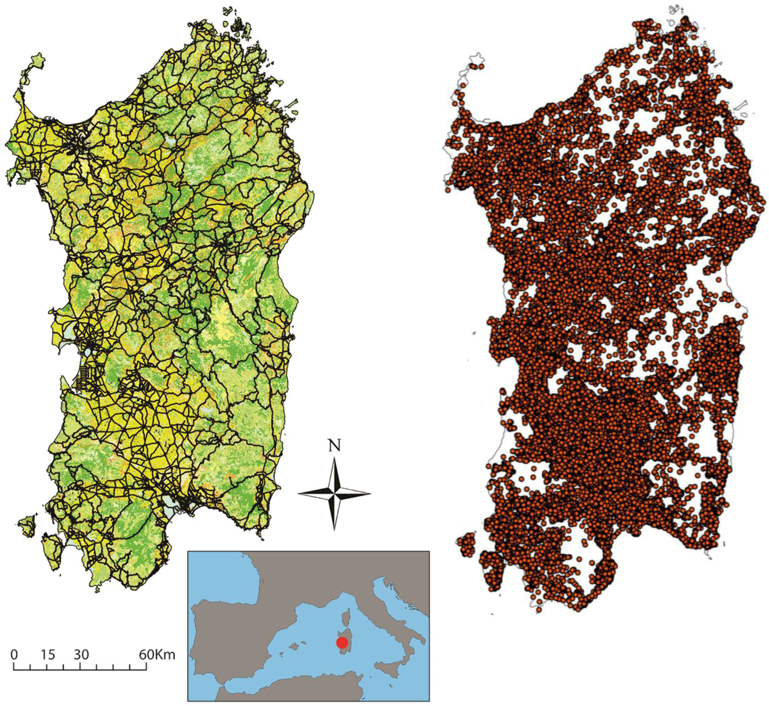
2.1. Study Area
2.2. Data Preprocessing
2.3. Data Analysis
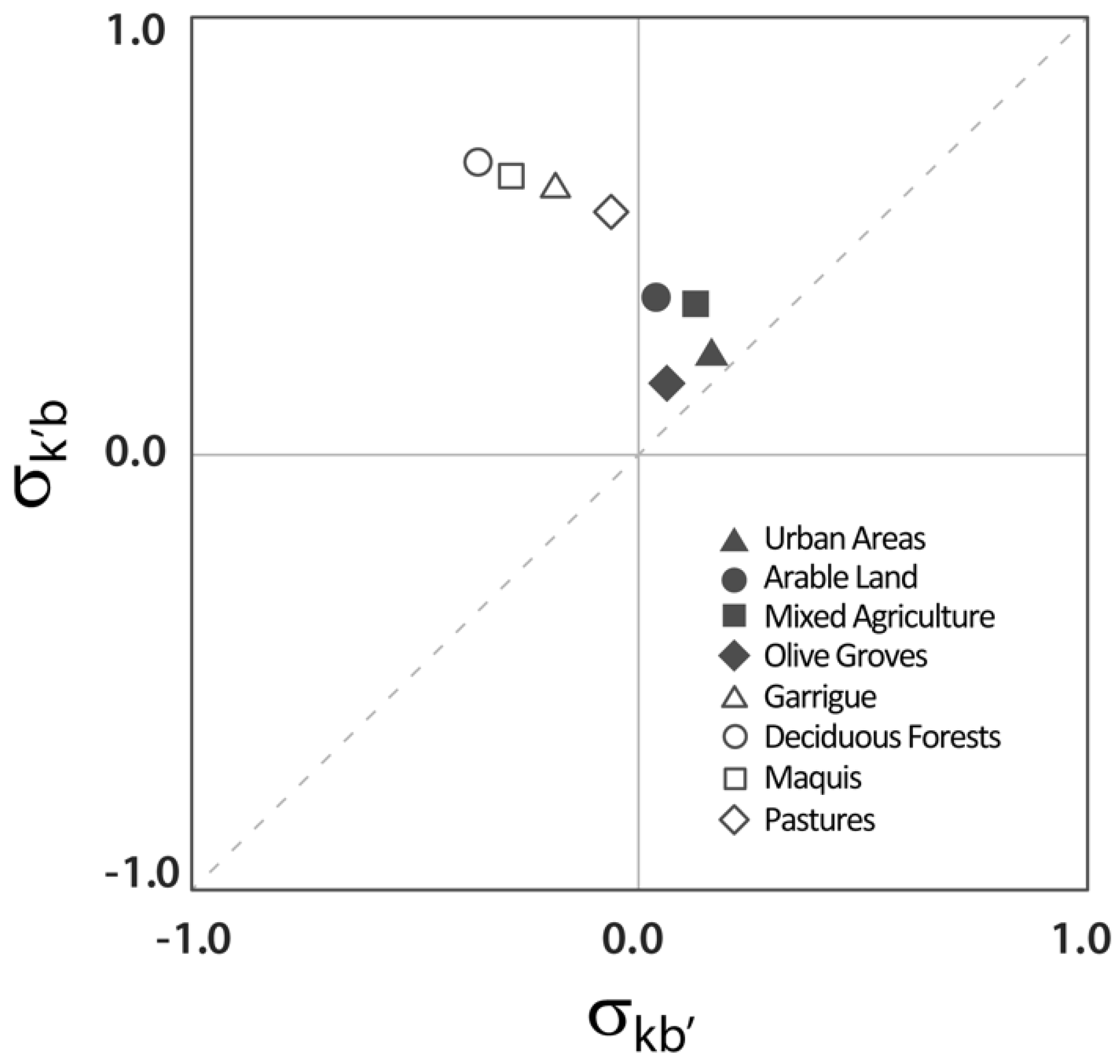
3. Results
4. Discussion
Author Contributions
Funding
Conflicts of Interest
References
- Krebs, P.; Pezzatti, G.B.; Mazzoleni, S.; Talbot, L.M.; Conedera, M. Fire regime: History and definition of a key concept in disturbance ecology. Theory Biosci. 2010, 129, 53–69. [Google Scholar] [CrossRef] [PubMed]
- Pyne, S.J. World Fire: The Culture of Fire on Earth; Henry Holt and Company: New York, NY, USA, 1995. [Google Scholar]
- Bowman, D.M.J.S.; O’Brien, J.A.; Goldammer, J.G. Pyrogeography and the global quest for sustainable fire management. Annu. Rev. Environ. Resour. 2013, 38, 57–80. [Google Scholar] [CrossRef]
- FAO. Fire Management—Global Assessment 2006; FAO Forestry Paper 151; FAO: Rome, Italy, 2007. [Google Scholar]
- Ganteaume, A.; Camia, A.; Jappiot, M.; San-Miguel-Ayanz, J.; Long-Fourne, l.M.; Lampin, C. A review of the main driving factors of forest fire ignition over Europe. Environ. Manag. 2013, 51, 651–662. [Google Scholar] [CrossRef] [PubMed]
- Moreno, M.V.; Chuvieco, E. Characterising fire regimes in Spain from fire statistics. Int. J. Wildland Fire 2013, 22, 296–305. [Google Scholar] [CrossRef]
- Cardille, J.A.; Ventura, S.J.; Turner, M.G. Environmental and social factors influencing wildfires in the Upper Midwest, United States. Ecol. Appl. 2001, 11, 111–127. [Google Scholar] [CrossRef]
- Syphard, A.D.; Radeloff, V.C.; Keeley, J.E.; Hawbaker, T.J.; Clayton, M.K.; Stewart, S.I.; Hammer, R.B. Human influence on California fire regimes. Ecol. Appl. 2007, 17, 1388–1402. [Google Scholar] [CrossRef] [PubMed]
- Syphard, A.D.; Radeloff, V.C.; Keuler, N.S.; Taylor, R.S.; Hawbaker, T.J.; Stewart, S.I.; Clayton, M.K. Predicting spatial patterns of fire on a southern California landscape. Int. J. Wildland Fire 2008, 17, 602–613. [Google Scholar] [CrossRef]
- Vázquez, A.; Moreno, J.M. Sensitivity of fire occurrence to meteorological variables in Mediterranean and Atlantic areas of Spain. Landsc. Urban Plan. 1993, 24, 129–142. [Google Scholar] [CrossRef]
- Viegas, D.X.; Viegas, M.T. A relationship between rainfall and burned area for Portugal. Int. J. Wildland Fire 1994, 4, 11–16. [Google Scholar] [CrossRef]
- Vázquez, A.; Pérez, B.; Fernández-González, F.; Moreno, J.M. Recent fire regime characteristics and potential natural vegetation relationships in Spain. J. Veg. Sci. 2002, 13, 663–676. [Google Scholar] [CrossRef]
- Lloret, F.; Pausas, J.G.; Vilà, M. Response of Mediterranean plant species to different fire regimes in Garraf Natural Park (Catalonia, Spain): Field observations and modelling predictions. Plant Ecol. 2003, 167, 223–235. [Google Scholar] [CrossRef]
- Flannigan, M.D.; Krawchuk, M.A.; de Groot, W.J.; Wotton, B.M.; Gowman, L.M. Implications of changing climate for global wildland fire. Int. J. Wildland Fire 2009, 18, 483–507. [Google Scholar] [CrossRef]
- Wotton, B.M.; Nock, C.A.; Flannigan, M.D. Forest fire occurrence and climate change in Canada. Int. J. Wildland Fire 2010, 19, 253–271. [Google Scholar] [CrossRef]
- Moreira, F.; Ferreira, P.G.; Rego FC Bunting, S. Landscape changes and breeding bird assemblages in northwestern Portugal: The role of fire. Landsc. Ecol. 2001, 16, 175–187. [Google Scholar] [CrossRef]
- Nunes, M.C.S.; Vasconcelos, M.J.; Pereira, J.M.C.; Dasgupta, N.; Alldredge, R.J. Land cover type and fire in Portugal: Do fires burn land cover selectively? Landsc. Ecol. 2005, 20, 661–673. [Google Scholar] [CrossRef]
- Bajocco, S.; Ricotta, C. Evidence of selective burning in Sardinia (Italy): Which land-cover classes do wildfires prefer? Landsc. Ecol. 2008, 23, 241–248. [Google Scholar] [CrossRef]
- Conedera, M.; Torriani, D.; Neff, C.; Ricotta C Bajocco, S.; Pezzatti, G.B. Using Monte Carlo simulations to estimate relative fire ignition danger in a low-to-medium fire-prone region. For. Ecol. Manag. 2011, 261, 2179–2187. [Google Scholar] [CrossRef]
- Guglietta, D.; Migliozzi, A.; Ricotta, C. A multivariate approach for mapping fire ignition risk: The example of the National Park of Cilento (Southern Italy). Environ. Manag. 2015, 56, 157–164. [Google Scholar] [CrossRef] [PubMed]
- Martell, D.L.; Otukol, S.; Stocks, B.J. A logistic model for predicting daily people-caused forest fire occurrence in Ontario. Can. J. For. Res. 1987, 17, 394–401. [Google Scholar] [CrossRef]
- Yang, J.; He, H.S.; Shifley, S.R.; Gustafson, E.J. Spatial patterns of modern period human-caused fire occurrence in the Missouri Ozark Highlands. For. Sci. 2007, 53, 1–15. [Google Scholar]
- Lampin-Maillet, C.; Jappiot, M.; Long, M.; Morge, D.; Ferrier, J.P. Characterization and mapping of dwelling types for forest fire prevention. Comput. Environ. Urban Syst. 2009, 33, 224–232. [Google Scholar] [CrossRef]
- Lampin-Maillet, C.; Jappiot, M.; Long, M.; Bouillon, C.; Morge, D.; Ferrier, J.P. Mapping wildland-urban interfaces at large scales integrating housing density and vegetation aggregation for fire prevention in the South of France. J. Environ. Manag. 2010, 91, 732–741. [Google Scholar] [CrossRef] [PubMed]
- Narayanaraj, G.; Wimberly, M.C. Influences of forest roads on the spatial patterns of human- and lightning-caused wildfire ignitions. Appl. Geogr. 2012, 32, 878–888. [Google Scholar] [CrossRef]
- Narayanaraj, G.; Wimberly, M.C. Influences of forest roads and their edge effects on the spatial pattern of burn severity. Int. J. Appl. Earth Obs. Geoinf. 2013, 23, 62–70. [Google Scholar] [CrossRef]
- Penman, T.D.; Bradstock, R.A.; Price, O. Modelling the determinants of ignition in the Sydney Basin, Australia: Implications for future management. Int. J. Wildland Fire 2013, 22, 469–478. [Google Scholar] [CrossRef]
- Pezzatti, G.B.; Zumbrunnen, T.; Bürgi, M.; Ambrosetti, P.; Conedera, M. Fire regime shifts as a consequence of fire policy and socio-economic development: An analysis based on the change point approach. For. Policy Econ. 2013, 29, 7–18. [Google Scholar] [CrossRef]
- Conedera, M.; Tonini, M.; Oleggini, L.; Vega Orozco, C.; Leuenberger, M.; Pezzatti, G.B. Geospatial approach for defining the Wildland-Urban Interface in the Alpine environment. Comput. Environ. Urban Syst. 2015, 52, 10–20. [Google Scholar] [CrossRef]
- Romero-Calcerrada, R.; Novillo, C.J.; Millington, J.D.A.; Gomez-Jimenez, I. GIS analysis of spatial patterns of human-caused wildfire ignition risk in the SW of Madrid (Central Spain). Landsc. Ecol. 2008, 23, 341–354. [Google Scholar] [CrossRef]
- Ager, A.A.; Preisler, H.K.; Arca, B.; Spano, D.; Salis, M. Wildfire risk estimation in the Mediterranean area. Environmetrics 2014, 25, 384–396. [Google Scholar] [CrossRef]
- Vilar, L.; Gómez, I.; Martínez-Vega, J.; Echavarría, P.; Riaño, D.; Martín, M.P. Multitemporal Modelling of Socio-Economic Wildfire Drivers in Central Spain between the 1980s and the 2000s: Comparing Generalized Linear Models to Machine Learning Algorithms. PLoS ONE 2016, 11, e0161344. [Google Scholar] [CrossRef] [PubMed]
- Ye, J.X.; Wu, M.S.; Deng, Z.J.; Xu, S.J.; Zhou, R.L.; Clarke, K.C. Modeling the spatial patterns of human wildfire ignition in Yunnan province, China. Appl. Geogr. 2017, 89, 150–162. [Google Scholar] [CrossRef]
- Salis, M.; Ager, A.A.; Alcasena, F.J.; Arca, B.; Finney, M.A.; Pellizzaro, G.; Spano, D. Analyzing seasonal patterns of wildfire exposure factors in Sardinia, Italy. Environ. Monit. Assess 2015, 187, 4175. [Google Scholar] [CrossRef] [PubMed]
- Bajocco, S.; Dragozi, E.; Gitas, I.; Smiraglia, D.; Salvati, L.; Ricotta, C. Mapping forest fuels through vegetation phenology: The role of coarse-resolution satellite time-series. PLoS ONE 2015, 10, e0119811. [Google Scholar] [CrossRef] [PubMed]
- ISPRA. La Realizzazione in Italia del Progetto Corine Land Cover 2006; Rapporto 131; Istituto Superiore per la Protezione e la Ricerca Ambientale: Rome, Italy, 2010. [Google Scholar]
- Nunes, A.N.; Lourenco, L.; Meira, A.C.C. Exploring spatial patterns and drivers of forest fires in Portugal (1980–2014). Sci. Total Environ. 2016, 573, 1190–1202. [Google Scholar] [CrossRef] [PubMed]
- Oliveira, S.; Pereira, J.M.C.; San-Miguel-Ayanz, J.; Lourenco, L. Exploring the spatial patterns of fire density in Southern Europe using Geographically Weighted Regression. Appl. Geogr. 2014, 51, 143–157. [Google Scholar] [CrossRef]
- Syphard, A.D.; Keeley, J.E. Location, timing and extent of wildfire vary by cause of ignition. Int. J. Wildland Fire 2015, 24, 37–47. [Google Scholar] [CrossRef]
- Costafreda-Aumedes, S.; Comas, C.; Vega-Garcia, C. Human-caused fire occurrence modelling in perspective: A review. Int. J. Wildland Fire 2017, 26, 983–998. [Google Scholar] [CrossRef]
- Yang, J.; He, H.S.; Sturtevant, B.R.; Miranda, B.R.; Gustafson, E.J. Comparing effects of fire modeling methods on simulated fire patterns and succession: A case study in the Missouri Ozarks. Can. J. For. Res. 2008, 38, 1290–1302. [Google Scholar] [CrossRef]
- Vega Orozco, C.; Tonini, M.; Conedera, M.; Kanevski, M. Cluster recognition in spatial-temporal sequences: The case of forest fires. Geoinformatica 2012, 16, 653–673. [Google Scholar] [CrossRef]
- Ricotta, C.; Di Vito, S. Modeling the Landscape Drivers of Fire Recurrence in Sardinia (Italy). Environ. Manag. 2014, 53, 1077–1084. [Google Scholar] [CrossRef] [PubMed]
- Theobald, D.M.; Romme, W.H. Expansion of the US wildland-urban interface. Landsc. Urban Plan. 2007, 83, 340–354. [Google Scholar] [CrossRef]
- Finney, M.A. The challenge of quantitative risk analysis for wildland fire. For. Ecol. Manag. 2005, 211, 97–108. [Google Scholar] [CrossRef]
- Curt, T.; Borgniet, L.; Bouillon, C. Wildfire frequency varies with the size and shape of fuel types in southeastern France: Implications for environmental management. J. Environ. Manag. 2013, 117, 150–161. [Google Scholar] [CrossRef] [PubMed]


| Land Cover Class | Number of Fires within Each Buffer | Total Number of Fires within Each Class | ||||
|---|---|---|---|---|---|---|
| 0–50 m | 0–100 m | 0–150 m | 0–200 m | |||
| Artificial and agricultural | Discontinuous urban areas | 365 | 624 | 793 | 931 | 1366 |
| Arable land | 1829 | 3332 | 4507 | 5429 | 10,599 | |
| Mixed agriculture | 1023 | 1888 | 2496 | 3025 | 5889 | |
| Olive groves | 279 | 512 | 711 | 893 | 2012 | |
| Natural and semi-natural | Deciduous forests | 320 | 581 | 789 | 943 | 2113 |
| Maquis | 332 | 596 | 788 | 955 | 2443 | |
| Garrigue | 230 | 442 | 609 | 755 | 1916 | |
| Pastures | 278 | 526 | 684 | 827 | 1951 | |
| Total number of fires within each buffer | 7326 | 13,499 | 18,272 | 22,234 | ||
| Land Cover Class | Class Area within Each Buffer (ha) | Total Class Area (ha) | ||||
| 0–50 m | 0–100 m | 0–150 m | 0–200 m | |||
| Artificial and agricultural | Discontinuous urban areas | 4536 | 8143 | 10,983 | 13,238 | 29,899 |
| Arable land | 29,714 | 57,249 | 82,805 | 106,326 | 415,700 | |
| Mixed agriculture | 14,791 | 28,168 | 40,264 | 51,162 | 199,000 | |
| Olive groves | 4353 | 8458 | 12,290 | 15,803 | 48,780 | |
| Natural and semi-natural | Deciduous forests | 9493 | 18,703 | 27,653 | 36,509 | 351,400 |
| Maquis | 9052 | 17,666 | 25,998 | 34,235 | 345,716 | |
| Garrigue | 5760 | 11,356 | 16,872 | 22,457 | 220,000 | |
| Pastures | 5544 | 10,794 | 15,725 | 20,477 | 144,800 | |
| Total area of each buffer (ha) | 123,721 | 238,490 | 345,267 | 444,967 | ||
| Land Cover Class | Selectivity Related to Land Cover | Selectivity Related to Buffer Size | |||||||
|---|---|---|---|---|---|---|---|---|---|
| 0–50 m | 0–100 m | 0–150 m | 0–200 m | 0–50 m | 0–100 m | 0–150 m | 0–200 m | ||
| Artificial and agricultural | Discontinuous urban areas | 0.276 | 0.253 | 0.225 | 0.212 | 0.152 | 0.150 | 0.154 | 0.169 |
| Arable land | 0.414 | 0.391 | 0.362 | 0.334 | 0.019 | 0.014 | 0.014 | 0.011 | |
| Mixed agriculture | 0.401 | 0.387 | 0.354 | 0.333 | 0.078 | 0.084 | 0.079 | 0.084 | |
| Olive groves | 0.217 | 0.190 | 0.168 | 0.156 | 0.040 | 0.034 | 0.045 | 0.061 | |
| Natural and semi-natural | Deciduous forests | 0.697 | 0.676 | 0.652 | 0.622 | −0.274 | −0.291 | −0.299 | −0.318 |
| Maquis | 0.677 | 0.654 | 0.622 | 0.596 | −0.235 | −0.253 | −0.272 | −0.283 | |
| Garrigue | 0.642 | 0.634 | 0.611 | 0.589 | −0.194 | −0.185 | −0.189 | −0.196 | |
| Pastures | 0.576 | 0.567 | 0.527 | 0.500 | −0.083 | −0.075 | −0.098 | −0.106 | |
© 2018 by the authors. Licensee MDPI, Basel, Switzerland. This article is an open access article distributed under the terms and conditions of the Creative Commons Attribution (CC BY) license (http://creativecommons.org/licenses/by/4.0/).
Share and Cite
Ricotta, C.; Bajocco, S.; Guglietta, D.; Conedera, M. Assessing the Influence of Roads on Fire Ignition: Does Land Cover Matter? Fire 2018, 1, 24. https://doi.org/10.3390/fire1020024
Ricotta C, Bajocco S, Guglietta D, Conedera M. Assessing the Influence of Roads on Fire Ignition: Does Land Cover Matter? Fire. 2018; 1(2):24. https://doi.org/10.3390/fire1020024
Chicago/Turabian StyleRicotta, Carlo, Sofia Bajocco, Daniela Guglietta, and Marco Conedera. 2018. "Assessing the Influence of Roads on Fire Ignition: Does Land Cover Matter?" Fire 1, no. 2: 24. https://doi.org/10.3390/fire1020024
APA StyleRicotta, C., Bajocco, S., Guglietta, D., & Conedera, M. (2018). Assessing the Influence of Roads on Fire Ignition: Does Land Cover Matter? Fire, 1(2), 24. https://doi.org/10.3390/fire1020024