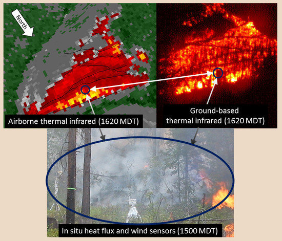
The Cooney Ridge Fire Experiment: An Early Operation to Relate Pre-, Active, and Post-Fire Field and Remotely Sensed Measurements
Abstract
:1. Introduction
2. Materials and Methods
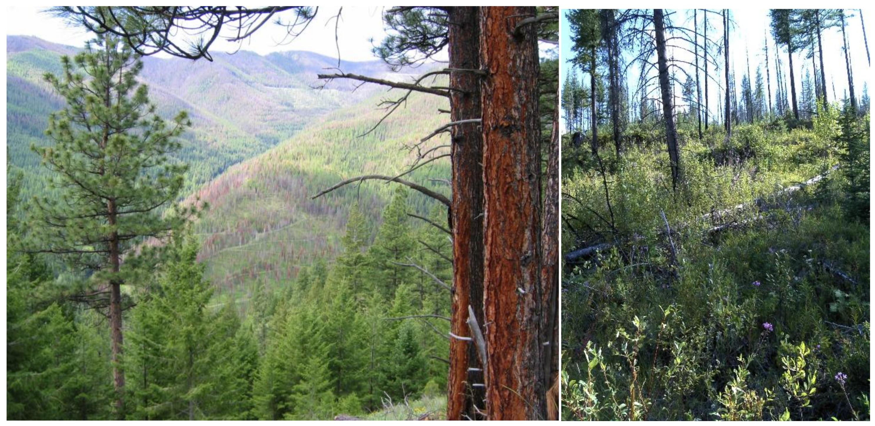
2.1. Study Area
2.2. Fuels and Vegetation
2.3. In Situ Heat Flux and Weather
2.4. Thermal Infrared Imagery
2.5. Hyperspectral Imagery
2.6. Combining Active and Post-Fire Measurements to Predict Fire Effects
3. Results
3.1. Tree Mortality
3.2. Fuel Loading and Consumption
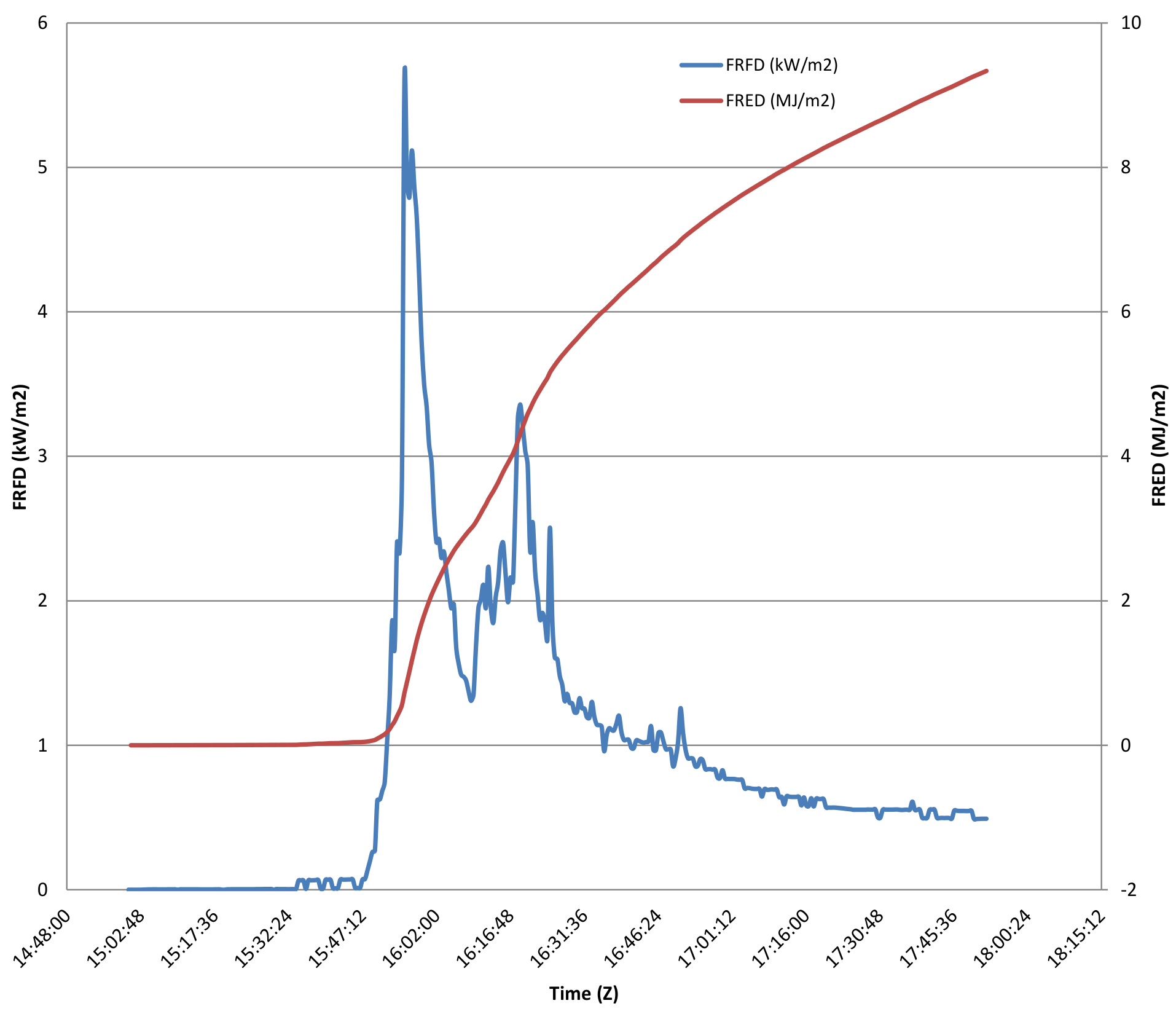
3.3. In Situ Heat Flux and Weather
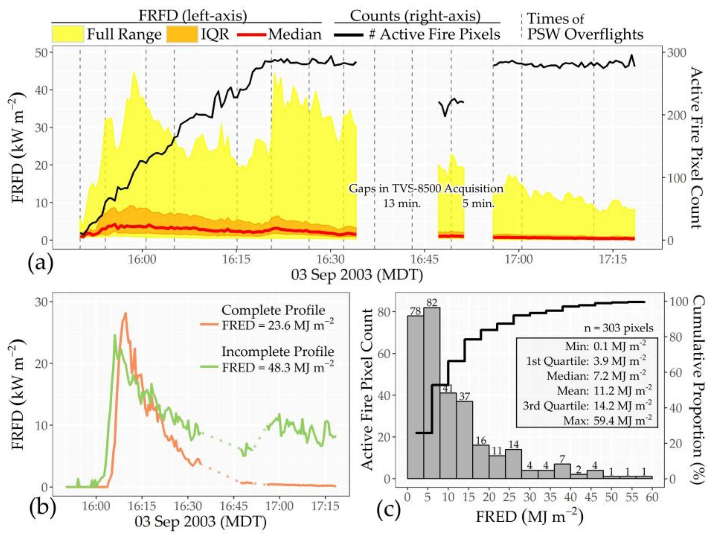
3.4. Thermal Infrared Imaging
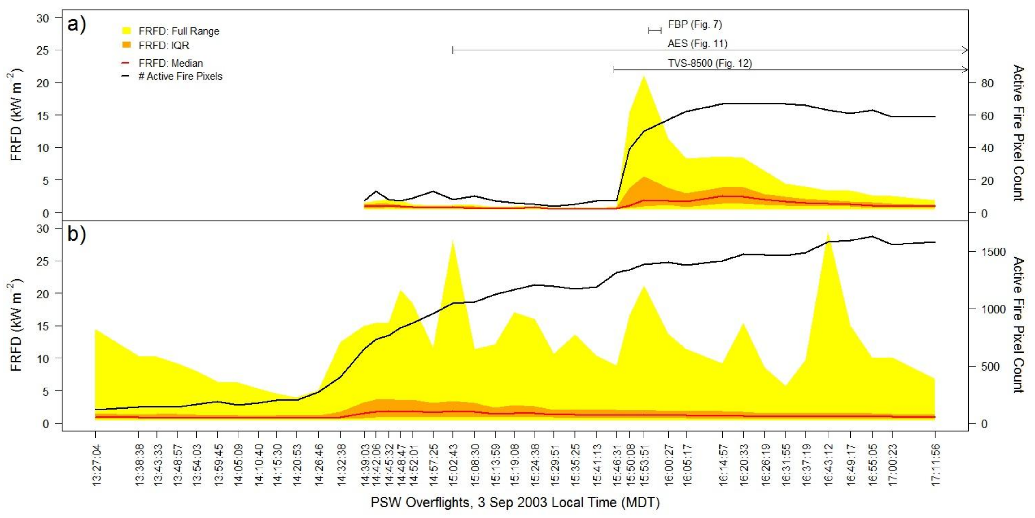
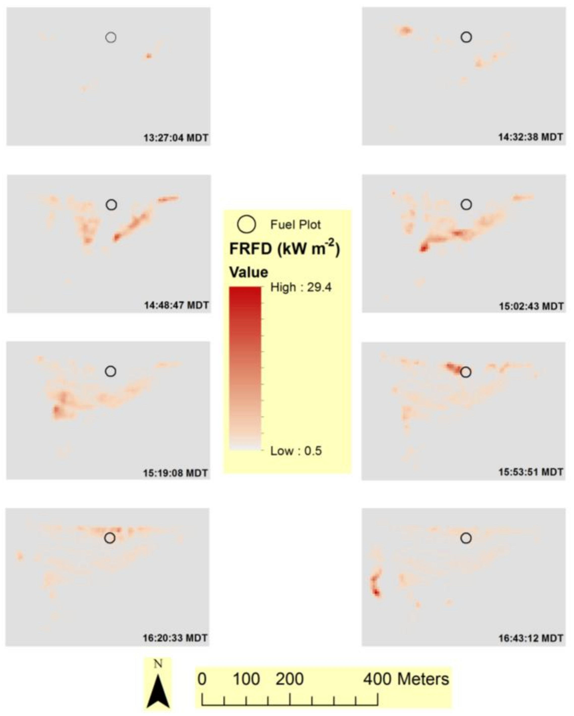
3.5. Multi-Scale Comparisons of Heat Flux Measurements
3.6. Fire Effects
3.7. Active and Post-Fire Imagery Combined to Predict Fire Effects
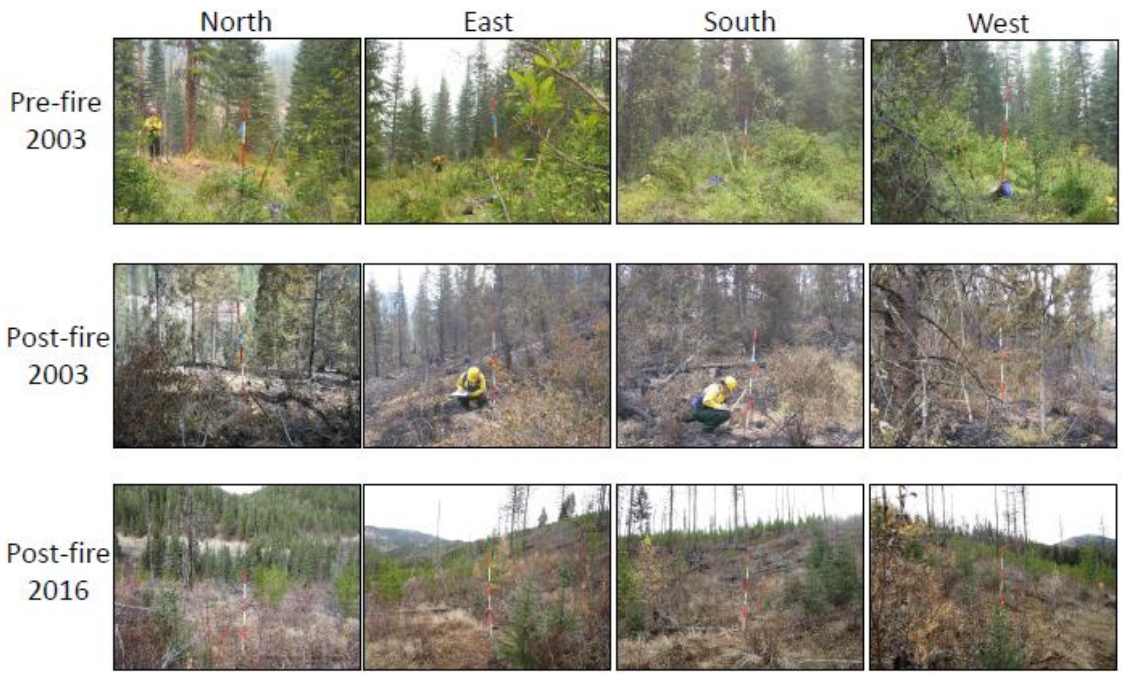
3.8. Site Recovery
4. Discussion
4.1. Fire Radiant Heat Flux
4.2. Fire Effects
5. Conclusions
Acknowledgments
Author Contributions
Conflicts of Interest
References
- Albini, F. Estimating Wildfire Behavior and Effects; General Technical Report INT-30; Intermountain Forest and Range Experiment Station, USDA Forest Service: Ogden, UT, USA, 1976; p. 92. [Google Scholar]
- Morandini, F.; Silvani, X. Experimental investigation of the physical mechanisms governing the spread of wildfires. Int. J. Wildland Fire 2010, 19, 570–582. [Google Scholar] [CrossRef]
- Frankman, D.; Webb, B.W.; Butler, B.W.; Jimenez, D.; Forthofer, J.M.; Sopko, P.; Shannon, K.S.; Hiers, J.K.; Ottmar, R.D. Measurements of convective and radiative heating in wildland fires. Int. J. Wildland Fire 2013, 22, 157–167. [Google Scholar] [CrossRef]
- Lentile, L.B.; Holden, Z.A.; Smith, A.M.S.; Falkowski, M.J.; Hudak, A.T.; Morgan, P.; Lewis, S.A.; Gessler, P.E.; Benson, N.C. Remote sensing techniques to assess active fire characteristics and post-fire effects. Int. J. Wildland Fire 2006, 15, 319–345. [Google Scholar] [CrossRef]
- Lewis, S.A.; Hudak, A.T.; Robichaud, P.R.; Morgan, P.; Satterberg, K.L.; Strand, E.K.; Smith, A.M.S.; Zamudio, J.A.; Lentile, L.B. Indicators of burn severity at extended temporal scales: A decade of ecosystem response in mixed conifer forests of western Montana. Int. J. Wildland Fire 2017, 26, 755–771. [Google Scholar] [CrossRef]
- Johnson, E.A.; Miyanishi, K. Forest Fires: Behavior and Ecological Effects; Academic Press: San Diego, CA, USA, 2001. [Google Scholar]
- Dickinson, M.B.; Ryan, K.C. Introduction: Strengthening the foundation of wildland fire effects prediction for research and management. Fire Ecol. 2010, 6, 1–12. [Google Scholar] [CrossRef]
- Meléndez, J.; Foronda, A.; Aranda, J.M.; Lopez, F.; Lopez del Cerro, F.J. Infrared thermography of solid surfaces in a fire. Meas. Sci. Technol. 2010, 21, 105504. [Google Scholar] [CrossRef]
- Butler, B.; Teske, C.; Jimenez, D.; O’Brien, J.; Sopko, P.; Wold, C.; Vosburgh, M.; Hornsby, B.; Loudermilk, E. Observations of energy transport and rate of spreads from low-intensity fires in longleaf pine habitat—RxCADRE 2012. Int. J. Wildland Fire 2016, 25, 76–89. [Google Scholar] [CrossRef]
- O’Brien, J.J.; Loudermilk, E.L.; Hornsby, B.; Hudak, A.T.; Bright, B.C.; Dickinson, M.B.; Hiers, J.K.; Ottmar, R.D. High resolution infrared thermography for capturing wildland fire behavior—RxCADRE 2012. Int. J. Wildland Fire 2016, 25, 62–75. [Google Scholar] [CrossRef]
- Lentile, L.B.; Morgan, P.; Hardy, C.; Hudak, A.; Means, R.; Ottmar, R.; Robichaud, P.; Kennedy Sutherland, E.; Szymoniak, J.; Way, F.; et al. Value and Challenges of Conducting Rapid Response Research on Wildland Fires; RMRS-GTR-193; U.S. Department of Agriculture, Forest Service, Rocky Mountain Research Station: Fort Collins, CO, USA, 2007; p. 16.
- Lentile, L.B.; Morgan, P.; Hardy, C.; Hudak, A.; Means, R.; Ottmar, R.; Robichaud, P.; Kennedy Sutherland, E.; Way, F.; Lewis, S. Lessons learned from rapid response research on wildland fires. Fire Manag. Today 2007, 67, 24–31. [Google Scholar]
- Morgan, P.; Keane, R.E.; Dillon, G.K.; Jain, T.B.; Hudak, A.T.; Karau, E.C.; Sikkink, P.G.; Holden, Z.A.; Strand, E.K. Challenges of assessing fire and burn severity using field measures, remote sensing and modelling. Int. J. Wildland Fire 2014, 23, 1045–1060. [Google Scholar] [CrossRef]
- Robichaud, P.R. Measurement of post-fire hillslope erosion to evaluate and model rehabilitation treatment effectiveness and recovery. Int. J. Wildland Fire 2005, 14, 475–485. [Google Scholar] [CrossRef]
- Robichaud, P.R.; Lewis, S.A.; Brown, R.E.; Ashmun, L.E. Emergency post-fire rehabilitation treatment effects on burned area ecology and long-term restoration. Fire Ecol. 2009, 5, 115–128. [Google Scholar] [CrossRef]
- Lentile, L.B.; Morgan, P.; Hudak, A.T.; Bobbitt, M.J.; Lewis, S.A.; Smith, A.M.S.; Robichaud, P.R. Burn severity and vegetation response following eight large wildfires across the western US. Fire Ecol. 2007, 3, 91–108. [Google Scholar] [CrossRef]
- Brown, J.K. Handbook for Inventorying Downed Woody Material; Gen. Tech. Rep. INT-16; U.S. Department of Agriculture, Forest Service, Intermountain Forest and Range Experiment Station: Ogden, UT, USA, 1974; p. 24.
- Lutes, D.C.; Keane, R.E.L.; Caratti, J.F.; Key, C.H.; Benson, N.C.; Sutherland, S.; Gangi, L.J. FIREMON: Fire Effects Monitoring and Inventory System; Gen. Tech. Rep. RMRS-GTR-164-CD; U.S. Department of Agriculture, Forest Service, Rocky Mountain Research Station: Fort Collins, CO, USA, 2006; p. HT-1-33.
- Hudak, A.T.; Morgan, P.; Bobbitt, M.J.; Smith, A.M.S.; Lewis, S.A.; Lentile, L.B.; Robichaud, P.R.; Clark, J.T.; McKinley, R.A. The relationship of multispectral satellite imagery to immediate fire effects. Fire Ecol. 2007, 3, 64–90. [Google Scholar] [CrossRef]
- Butler, B.W.; Jimenez, D. In situ measurements of fire behavior. In Proceedings of the 4th International Fire Ecology & Management Congress: Fire as a Global Process, Savannah, GA, USA, 30 November–4 December 2009. [Google Scholar]
- Butler, B.W. Experimental measurements of radiant heat fluxes from simulated wildfire flames. In Proceedings of the 12th International Conference of Fire and Forest Meteorology, Jekyll Island, GA, USA, 26–28 October 1993; Volume 1, pp. 104–111. [Google Scholar]
- McCaffrey, B.J.; Heskestad, G.A. robust bidirectional low-velocity probe for flame and fire application. Combust. Flame 1976, 26, 125–127. [Google Scholar] [CrossRef]
- Smith, A.M.S.; Tinkham, W.T.; Roy, D.P.; Boschetti, L.; Kumar, S.; Sparks, A.M.; Kremens, R.L.; Falkowski, M.J. Quantification of fuel moisture effects on biomass consumed derived from fire radiative energy retrievals. Geophys. Res. Lett. 2013, 40, 6298–6302. [Google Scholar] [CrossRef]
- Freeborn, P.H.; Nordgren, B.L.; Hao, W.M.; Wakimoto, R.H.; Queen, L.P. Ground-based thermal observations of the Black Mountain 2 Fire in west-central Montana, 2003. In Proceedings of the Tenth Biennial USDA Forest Service Remote Sensing Applications Conference, Salt Lake City, UT, USA, 5–9 April 2004. [Google Scholar]
- Wooster, M.J.; Zhukov, B.; Oertel, D. Fire radiative energy for quantitative study of biomass burning: Derivation from the BIRD experimental satellite and comparison to MODIS fire products. Remote Sens. Environ. 2003, 86, 83–107. [Google Scholar] [CrossRef]
- Freeborn, P.H.; Wooster, M.J.; Hao, W.M.; Ryan, C.A.; Nordgren, B.L.; Baker, S.P.; Ichoku, C. Relationships between energy release, fuel mass loss, and trace gas and aerosol emissions during laboratory biomass fires. J. Geophys. Res. Atmos. 2008, 113, 2156–2202. [Google Scholar] [CrossRef]
- Kaufman, Y.J.; Justice, C.O.; Flynn, L.P.; Kendall, J.D.; Prins, E.M.; Giglio, L.; Ward, D.E.; Menzel, W.P.; Setzer, A.W. Potential global fire monitoring from EOS-MODIS. J. Geophys. Res. 1998, 103, 32215–32238. [Google Scholar] [CrossRef]
- Leica Geosystems GIS and Mapping. Leica Photogrammetry Suite OrthoBASE and OrthoBASE Pro User’s Guide; Leica Geosystems GIS and Mapping: Atlanta, GA, USA, 2003. [Google Scholar]
- Leica Geosystems GIS and Mapping. ERDAS Imagine Tour Guides; Leica Geosystems GIS and Mapping: Atlanta, GA, USA, 2006. [Google Scholar]
- Boschetti, L.; Roy, D.P. Strategies for the fusion of satellite fire radiative power with burned area data for fire radiative energy derivation. J. Geophys. Res. 2009, 114, D20302. [Google Scholar] [CrossRef]
- Clark, R.N.; Swayze, G.A.; Livo, K.E.; Kokaly, R.F.; King, T.V.; Dalton, J.B.; Vance, J.S.; Rockwell, B.W.; Hoefen, T.; McDougal, R.R. Surface reflectance calibration of terrestrial imaging spectroscopy data: A tutorial using AVIRIS. In Proceedings of the 10th JPL Airborne Sciences Workshop, Pasadena, CA, USA, 27 February–2 March 2001. [Google Scholar]
- Richards, J.A.; Jia, X. Remote Sensing Digital Image Analysis: An Introduction, 3rd ed.; Springer: Berlin, Germany, 1999. [Google Scholar]
- Roberts, D.A.; Gardner, M.; Church, R.; Ustin, S.; Scheer, G.; Green, R.O. Mapping chaparral in the Santa Monica Mountains using multiple endmember spectral mixture models. Remote Sens. Environ. 1998, 65, 267–279. [Google Scholar] [CrossRef]
- Tompkins, S.; Mustard, J.F.; Pieters, C.M.; Forsyth, D.W. Optimization of endmembers for spectral mixture analysis. Remote Sens. Environ. 1997, 59, 472–489. [Google Scholar] [CrossRef]
- Dennison, P.E.; Roberts, D.A. Endmember selection for multiple endmember spectral mixture analysis using endmember average RMSE. Remote Sens. Environ. 2003, 87, 123–135. [Google Scholar] [CrossRef]
- Akaike, H. A new look at the statistical model identification. IEEE Trans. Autom. Control 1974, 19, 716–723. [Google Scholar] [CrossRef]
- Haining, R. Spatial Data Analysis in the Social and Environmental Sciences; Cambridge University Press: Cambridge, UK, 1990. [Google Scholar]
- Cressie, N.A.C. Statistics for Spatial Data; Wiley: New York, NY, USA, 1993. [Google Scholar]
- Lewis, S.A.; Hudak, A.T.; Lentile, L.B.; Ottmar, R.D.; Cronan, J.B.; Hood, S.M.; Robichaud, P.R.; Morgan, P. Using hyperspectral imagery to estimate forest floor consumption from wildfire in boreal forests of Alaska, USA. Int. J. Wildland Fire 2011, 20, 255–271. [Google Scholar] [CrossRef]
- R Core Team. R: A Language and Environment for Statistical Computing; R Foundation for Statistical Computing: Vienna, Austria, 2014. [Google Scholar]
- Hardy, C.C.; Riggan, P.J. Demonstration and Integration of Systems for Fire Remote Sensing, Ground-Based Fire Measurement, and Fire Modeling; Joint Fire Science Program Project Final Report (JFSP-03-S-01); Joint Fire Science Program: Boise, ID, USA, 2006; p. 93.
- Hudak, A.T.; Morgan, P.; Bobbitt, M.; Lentile, L. Characterizing stand-replacing harvest and fire disturbance patches in a forested landscape: A case study from Cooney Ridge, Montana. In Understanding Forest Disturbance and Spatial Patterns: Remote Sensing and GIS Approaches; Wulder, M.A., Franklin, S.E., Eds.; Taylor & Francis: London, UK, 2007; Chapter 8; pp. 209–231. [Google Scholar]
- Wooster, M.J.; Roberts, G.; Perry, G.L.W.; Kaufman, Y.J. Retrieval of biomass combustion rates and totals from fire radiative power observations: FRP derivation and calibration relationships between biomass consumption and fire radiative energy release. J. Geophys. Res. D Atmos. 2005, 110, D24311. [Google Scholar] [CrossRef]
- Kremens, R.L.; Dickinson, M.B.; Bova, A.S. Radiant flux density, energy density, and fuel consumption in mixed-oak forest surface fires. Int. J. Wildland Fire 2012, 21, 722–730. [Google Scholar] [CrossRef]
- Smith, A.M.S.; Hudak, A.T. Estimating combustion of large downed woody debris from residual white ash. Int. J. Wildland Fire 2005, 14, 1–4. [Google Scholar]
- Hudak, A.T.; Ottmar, R.; Vihnanek, B.; Brewer, N.; Smith, A.M.S.; Morgan, P. The relationship of post-fire white ash cover to surface fuel consumption. Int. J. Wildland Fire 2013, 22, 580–585. [Google Scholar] [CrossRef]
- Wooster, M.J.; Roberts, G.; Smith, A.M.S.; Johnston, J.; Freeborn, P.; Amici, S.; Hudak, A.T. Thermal remote sensing of active fires and biomass burning events. In Thermal Infrared Remote Sensing: Sensors, Methods, Applications; Remote Sensing and Digital Image Processing 17; Kuenzer, C., Dech, S., Eds.; Springer: Dordrecht, The Netherlands, 2013; Chapter 18; pp. 347–390. [Google Scholar]
- Riggan, P.J.; Tissell, R.G.; Lockwood, R.N.; Brass, J.A.; Pereira, J.A.R.; Miranda, H.S.; Miranda, A.C.; Campos, T.; Higgins, R.G. Remote measurement of energy and carbon flux from wildfires in Brazil. Ecol. Appl. 2004, 14, 855–872. [Google Scholar] [CrossRef]
- Monod, B.; Collin, A.; Parent, G.; Boulet, P. Infrared radiative properties of vegetation involved in forest fires. Fire Saf. J. 2009, 44, 88–95. [Google Scholar] [CrossRef]
- Boulet, P.; Parent, G.; Acem, Z.; Collin, A.; Sero-Guillaume, O. On the emission of radiation by flames and corresponding absorption by vegetation in forest fires. Fire Saf. J. 2011, 46, 21–26. [Google Scholar] [CrossRef]
- Allison, R.S.; Johnston, J.M.; Craig, G.; Jennings, S. Airborne optical and thermal remote sensing for wildfire detection and monitoring. Sensors 2016, 16, 1310. [Google Scholar] [CrossRef] [PubMed]
- Wang, Z.; Vodacek, A.; Coen, J. Generation of synthetic infrared remote-sensing scenes of wildland fire. Int. J. Wildland Fire 2009, 18, 302–309. [Google Scholar] [CrossRef]
- Frankman, D.; Webb, B.M.; Butler, B.W.; Jimenez, D.; Harrington, M. The effect of sampling rate on interpretation of the temporal characteristics of radiative and convective heating in wildland flames. Int. J. Wildland Fire 2013, 22, 168–173. [Google Scholar] [CrossRef]
- Kremens, R.L.; Smith, A.M.S.; Dickinson, M.B. Fire metrology: Current and future directions in physics-based measurements. Fire Ecol. 2010, 6, 13–35. [Google Scholar] [CrossRef]
- Paugam, R.; Wooster, M.J.; Roberts, G. Use of handheld thermal imager data for airborne mapping of fire radiative power and energy and flame front rate of spread. IEEE Trans. Geosci. Remote Sens. 2013, 51, 3385–3399. [Google Scholar] [CrossRef]
- Luderer, G.; Trentmann, J.; Andreae, M.O. A new look at the role of fire-released moisture on the dynamics of atmospheric pyro-convection. Int. J. Wildland Fire 2009, 18, 554–562. [Google Scholar] [CrossRef]
- Clements, C.B.; Heilman, W.E. The grass fires on slopes experiment. In Proceedings of the 14th Conference on Mountain Meteorology, Olympic Valley, CA, USA, 30 August–3 September 2010. [Google Scholar]
- Dickinson, M.B.; Hudak, A.T.; Zajkowski, T.; Loudermilk, E.L.; Schroeder, W.; Ellison, L.; Kremens, R.L.; Holley, W.; Martinez, O.; Paxton, A. Measuring radiant emissions from entire prescribed fires with ground, airborne and satellite sensors-RxCADRE 2012. Int. J. Wildland Fire 2016, 25, 48–61. [Google Scholar] [CrossRef]
- Hudak, A.T.; Dickinson, M.B.; Bright, B.C.; Kremens, R.L.; Loudermilk, E.L.; O’Brien, J.J.; Hornsby, B.; Ottmar, R.D. Measurements relating fire radiative energy density and surface fuel consumption—RxCADRE 2011 and 2012. Int. J. Wildland Fire 2016, 25, 25–37. [Google Scholar] [CrossRef]
- Ottmar, R.D.; Hiers, J.K.; Butler, B.; Clements, C.B.; Dickinson, M.B.; Hudak, A.T.; O’Brien, J.J.; Potter, B.E.; Rowell, E.M.; Strand, T.M.; et al. Measurements, datasets and preliminary results from the RxCADRE project—2008, 2011 and 2012. Int. J. Wildland Fire 2016, 25, 1–9. [Google Scholar] [CrossRef]
- Smith, A.M.S.; Sparks, A.M.; Kolden, C.A.; Abatzoglou, J.T.; Talhelm, A.F.; Johnson, D.M.; Boschetti, L.; Lutz, J.A.; Apostol, K.G.; Yedinak, K.M.; et al. Towards a new paradigm in fire severity research using dose-response experiments. Int. J. Wildland Fire 2016, 25, 158–166. [Google Scholar] [CrossRef]
- Van Wagtendonk, J.W.; Root, R.R.; Key, C.H. Comparison of AVIRIS and Landsat ETM+ detection capabilities for burn severity. Remote Sens. Environ. 2004, 92, 397–408. [Google Scholar] [CrossRef]
- Lewis, S.A.; Lentile, L.B.; Hudak, A.T.; Robichaud, P.R.; Morgan, P.; Bobbitt, M.J. Mapping ground cover using hyperspectral remote sensing after the 2003 Simi and Old wildfires in southern California. Fire Ecol. 2007, 3, 109–128. [Google Scholar] [CrossRef]
- Robichaud, P.R.; Lewis, S.A.; Laes, D.Y.M.; Hudak, A.T.; Kokaly, R.F.; Zamudio, J.A. Postfire soil burn severity mapping with hyperspectral image unmixing. Remote Sens. Environ. 2007, 108, 467–480. [Google Scholar] [CrossRef]
- Quintano, C.; Fernandez-Manso, A.; Roberts, D.A. Multiple Endmember Spectral Mixture Analysis (MESMA) to map burn severity levels from Landsat images in Mediterranean countries. Remote Sens. Environ. 2013, 136, 76–88. [Google Scholar] [CrossRef]
- Veraverbeke, S.; Hook, S.J. Evaluating spectral indices and spectral mixture analysis for assessing fire severity, combustion completeness, and carbon emissions. Int. J. Wildland Fire 2013, 22, 707–720. [Google Scholar] [CrossRef]
- Fernandez-Manso, A.; Quintano, C.; Roberts, D.A. Burn severity influence on post-fire vegetation cover resilience from Landsat MESMA fraction images time series in Mediterranean forest ecosystems. Remote Sens. Environ. 2016, 184, 112–123. [Google Scholar] [CrossRef]
- Robichaud, P.R.; Wagenbrenner, J.W.; Pierson, F.B.; Spaeth, K.E.; Ashmun, L.E.; Moffet, C.A. Infiltration and interrill erosion rates after a wildfire in western Montana, USA. Catena 2016, 142, 77–88. [Google Scholar] [CrossRef]
- Keeley, J.E.; Bond, W.J.; Bradstock, R.A.; Pausas, J.G.; Rundel, P.W. Fire in Mediterranean Ecosystems: Ecology, Evolution and Management; Cambridge University Press: Cambridge, UK, 2012. [Google Scholar]
- Sparks, A.M.; Smith, A.M.; Talhelm, A.F.; Kolden, C.A.; Yedinak, K.M.; Johnson, D.M. Impacts of fire radiative flux on mature Pinus ponderosa growth and vulnerability to secondary mortality agents. Int. J. Wildland Fire 2017, 26, 95–106. [Google Scholar] [CrossRef]
- Smith, A.M.S.; Talhelm, A.F.; Johnson, D.M.; Sparks, A.M.; Kolden, C.A.; Yedinak, K.M.; Apostol, K.G.; Tinkham, W.T.; Abatzoglou, J.T.; Lutz, J.A.; et al. Effects of fire radiative energy density dose on Pinus contorta and Larix occidentalis seedling physiology and mortality. Int. J. Wildland Fire 2017, 26, 82–94. [Google Scholar] [CrossRef]
- Hinzman, L.D.; Fukuda, M.; Sandberg, D.V.; Chapin, F.S., III; Dash, D. FROSTFIRE: An experimental approach to predicting the climate feedbacks from the changing boreal fire regime. J. Geophys. Res. 2003, 108, FFR 9-1–FFR 9-6. [Google Scholar] [CrossRef]
- Stocks, B.J.; Alexander, M.E.; Lanoville, R.A. Overview of the International Crown Fire Modelling Experiment (ICFME). Can. J. For. Res. 2004, 34, 1543–1547. [Google Scholar] [CrossRef]
- Vaillant, N.M.; Ewell, C.M.; Fites-Kaufman, J.A. Capturing crown fire behavior on wildland fires—The Fire Behavior Assessment Team in action. Fire Manag. Today 2014, 73, 41–45. [Google Scholar]



| Instrument | Cincinnati TVS-8500 | FireMapperTM |
|---|---|---|
| Manufacturer | CMC Electronics | Space Instruments |
| Spectral Bands | 3.4–4.1 μm 4.5–5.1 μm | 8.1–9.0 μm 11.4–12.4 μm |
| Image Dimensions | 236 × 256 pixels | 327 × 205 pixels |
| Raw Image Resolution | 0.8 m | 4.5 m |
| Uncompressed Image Size | 121 KB | 134 KB |
| Image Encoding | 14 bit | 16 bit |
| Instantaneous Field of View | 1 milliradian | 1.85 milliradians |
| Field of View | 14.6° | 35° (crosstrack) |
| Sensor Position | 785 m horizontal distance 176 m vertical distance | 3500 meters AGL |
| Species | Sample Event | Live Trees (ha−1) | Live Basal Area (m2 ha−1) | Avg. Live Crown Base Height (m) | Avg. Height (m) | QMD (cm) | Saplings (ha−1) | Seedlings (ha−1) | Total Live (ha−1) | Snags (ha−1) |
|---|---|---|---|---|---|---|---|---|---|---|
| Subalpine fir | Pre | 98.8 | 2.8 | 1.6 | 16.5 | 18.9 | 197.7 | 3459.4 | 3755.9 | 0 |
| Post | 0 | 0 | 0 | 0 | 0 | 0 | 741.3 | 741.3 | 98.8 | |
| Difference | −98.8 | −2.8 | −1.6 | −16.5 | −18.9 | −197.7 | −2718.1 | −3014.6 | 98.8 | |
| Western larch | Pre | 24.7 | 1.6 | 4.3 | 25.9 | 29 | 0 | 0 | 24.7 | 0 |
| Post | 24.7 | 1.6 | 25.9 | 29 | 0 | 0 | 24.7 | 0 | ||
| Difference | 0 | 0 | −4.3 | 0 | 0 | 0 | 0 | 0 | 0 | |
| Engelmann spruce | Pre | 0 | 0 | 0 | 0 | 0 | 49.4 | 2223.9 | 2273.3 | 0 |
| Post | 0 | 0 | 0 | 0 | 0 | 0 | 0 | 0 | 0 | |
| Difference | 0 | 0 | 0 | 0 | 0 | −49.4 | −2223.9 | −2273.3 | 0 | |
| Douglas fir | Pre | 49.4 | 2.6 | 1.8 | 17.5 | 26 | 24.7 | 3459.4 | 3533.5 | 0 |
| Post | 0 | 0 | 0 | 0 | 0 | 0 | 741.3 | 741.3 | 49.4 | |
| Difference | −49.4 | −2.6 | −1.8 | −17.5 | −26 | −24.7 | −2718.1 | −2792.2 | 49.4 | |
| Total Trees | Pre | 173 | 7 | 2 | 18.1 | 22.7 | 271.8 | 9142.7 | 9587.5 | 0 |
| Post | 24.7 | 1.6 | 4.3 | 25.9 | 29 | 0 | 1482.6 | 1507.3 | 148.3 | |
| Difference | −148.3 | −5.4 | 2.3 | 7.8 | 6.3 | −271.8 | −7660.1 | −8080.2 | 148.3 |
| Fuel Fraction | 2003 (Fuel Plot) | 2013 (Fuel Plot) | 2013 (Fire Effects Plots) | |||
|---|---|---|---|---|---|---|
| Pre-Fire (kg m−2) | Post-Fire (kg m−2) | Difference (kg m−2) | Consumption (%) | (kg m−2) | (kg m−2) | |
| 1000 h | 1.513 | 0.000 | −1.513 | 100.00 | NA | 2.30 1 |
| 100 h | 0.170 | 0.170 | 0.000 | 0.00 | 0.00 | 1.38 (1.81) |
| 10 h | 0.518 | 0.208 | −0.309 | 59.74 | 0.02 | 0.68 (0.75) |
| 1 h | 0.016 | 0.013 | −0.002 | 14.29 | 0.05 | 0.22 (0.24) |
| Litter | 3.699 | 0.135 | −3.564 | 96.36 | 0.53 | 0.47 (0.18) |
| Duff | 0.000 | 0.000 | 0.000 | 0.00 | 1.27 | 1.20 (0.38) |
| Total | 5.916 | 0.527 | −5.389 | 91.10 | 1.87 | 6.25 |
| Post-Fire Measurement | 2003 (n = 13 plots) | 2004 (n = 6 plots) | 2013 (n = 6 plots) |
|---|---|---|---|
| overstory canopy closure (%) | 38.6 (14.1) | 44.6 (28.0) | 10.9 (9.6) |
| plant species richness (m−2) | 0.0 (0.0) | 5.5 (4.5) | 12.5 (2.4) |
| plant cover (%) 1 | 0.0 (0.0) | 46.7 (13.8) | 82.5 (25.6) |
| green vegetation (%) 2 | 0.0 (0.0) | 35.2 (17.3) | 65.0 (14.0) |
| organic (%) 3 | 45.3 (21.7) | 35.2 (12.4) | 31.5 (11.4) |
| inorganic (%) 4 | 49.8 (21.0) | 26.7 (20.9) | 3.5 (5.8) |
| ash (%) | 4.9 (3.8) | 3.6 (4.3) | 0.0 (0.0) |
| char (%) 5 | 77.8 (21.0) | 35.1 (23.7) | 9.9 (12.5) |
| litter (mm) | 9.1 (4.1) | 4.0 (3.6) | 10.7 (4.0) |
| duff (mm) | 20.3 (7.5) | 17.5 (10.6) | 11.3 (3.6) |
| A) Litter Cover | |||||
| 1) Linear Regression | Estimate | SE | t value | Pr (>|t|) | |
| (Intercept) | 110.29 | 17.75 | 6.21 | 3.17 × 10⁻⁹ | |
| Airborne FRED | −1.21 | 0.31 | −3.95 | 1.08 × 10⁻⁴ | |
| MESMA Soil | −274.92 | 80.21 | −3.43 | 7.46 × 10⁻⁴ | |
| MESMA Green | 96.48 | 48.95 | 1.97 | 0.05 | |
| Model Statistics: | RMSE = 28. 92; R2 = 0.30; p-value = 6.01 × 10⁻¹⁵ | ||||
| Residual Autocorrelation: | Moran’s I p-value = 0.0007; Geary’s C p-value = 0.0011 | ||||
| 2) Spatial Autoregression | Estimate | SE | z value | Pr (>|z|) | |
| (Intercept) | 77.42 | 18.25 | 4.24 | 2.21 × 10⁻⁵ | |
| Airborne FRED | −0.81 | 0.29 | −2.77 | 5.59 × 10⁻³ | |
| MESMA Soil | −210.62 | 76.50 | −2.75 | 5.90 × 10⁻³ | |
| MESMA Green | 47.56 | 46.76 | 1.02 | 0.31 | |
| Model Statistics: | RMSE = 27.35; R2 = 0.38; p-value = 6.62 × 10⁻⁵ | ||||
| Residual Autocorrelation: | Moran’s I p-value = 0.7723; Geary’s C p-value = 0.7757 | ||||
| 3) ANOVA Comparison | df | AIC | logLik | L. Ratio | p-value |
| Linear Regression | 5 | 1875.6 | −932.78 | ||
| Spatial Autoregression | 6 | 1861.7 | −924.82 | 15.916 | 6.62 × 10⁻⁵ |
| B) Mineral Soil Cover | |||||
| 1) Linear Regression | Estimate | SE | t value | Pr (>|t|) | |
| (Intercept) | −21.91 | 16.61 | −1.32 | 0.19 | |
| Airborne FRED | 1.17 | 0.29 | 4.09 | 6.49 × 10⁻⁵ | |
| MESMA Soil | 306.01 | 75.06 | 4.08 | 6.69 × 10⁻⁵ | |
| MESMA Green | −80.91 | 45.81 | −1.77 | 0.08 | |
| Model Statistics: | RMSE = 27.07; R2 = 0.33; p-value = 2.2 × 10⁻¹⁶ | ||||
| Residual Autocorrelation: | Moran’s I p-value = 0.0059; Geary’s C p-value = 0.0114 | ||||
| 2) Spatial Autoregression | Estimate | SE | z value | Pr (>|z|) | |
| (Intercept) | −24.99 | 15.86 | −1.58 | 0.12 | |
| Airborne FRED | 0.85 | 0.28 | 3.04 | 2.37 × 10⁻³ | |
| MESMA Soil | 248.15 | 73.41 | 3.38 | 7.24 × 10⁻⁴ | |
| MESMA Green | −44.93 | 44.64 | −1.01 | 0.31 | |
| Model Statistics: | RMSE = 26.08; R2 = 0.38; p-value = 1.02 × 10⁻³ | ||||
| Residual Autocorrelation: | Moran’s I p-value = 0.7422; Geary’s C p-value = 0.7728 | ||||
| 3) ANOVA Comparison | df | AIC | logLik | L. Ratio | p-value |
| Linear Regression | 5 | 1849.7 | −919.86 | ||
| Spatial Autoregression | 6 | 1841.1 | −914.56 | 10.595 | 1.13 × 10⁻³ |
| Spectral Bandpass and Response: |
|
|
|
| Temporal Resolution and Coverage: |
|
|
|
|
| Spatial Resolution, Coverage and Viewing Geometry: |
|
|
|
|
|
|
|
|
|
© 2018 by the authors. Licensee MDPI, Basel, Switzerland. This article is an open access article distributed under the terms and conditions of the Creative Commons Attribution (CC BY) license (http://creativecommons.org/licenses/by/4.0/).
Share and Cite
Hudak, A.T.; Freeborn, P.H.; Lewis, S.A.; Hood, S.M.; Smith, H.Y.; Hardy, C.C.; Kremens, R.J.; Butler, B.W.; Teske, C.; Tissell, R.G.; et al. The Cooney Ridge Fire Experiment: An Early Operation to Relate Pre-, Active, and Post-Fire Field and Remotely Sensed Measurements. Fire 2018, 1, 10. https://doi.org/10.3390/fire1010010
Hudak AT, Freeborn PH, Lewis SA, Hood SM, Smith HY, Hardy CC, Kremens RJ, Butler BW, Teske C, Tissell RG, et al. The Cooney Ridge Fire Experiment: An Early Operation to Relate Pre-, Active, and Post-Fire Field and Remotely Sensed Measurements. Fire. 2018; 1(1):10. https://doi.org/10.3390/fire1010010
Chicago/Turabian StyleHudak, Andrew T., Patrick H. Freeborn, Sarah A. Lewis, Sharon M. Hood, Helen Y. Smith, Colin C. Hardy, Robert J. Kremens, Bret W. Butler, Casey Teske, Robert G. Tissell, and et al. 2018. "The Cooney Ridge Fire Experiment: An Early Operation to Relate Pre-, Active, and Post-Fire Field and Remotely Sensed Measurements" Fire 1, no. 1: 10. https://doi.org/10.3390/fire1010010
APA StyleHudak, A. T., Freeborn, P. H., Lewis, S. A., Hood, S. M., Smith, H. Y., Hardy, C. C., Kremens, R. J., Butler, B. W., Teske, C., Tissell, R. G., Queen, L. P., Nordgren, B. L., Bright, B. C., Morgan, P., Riggan, P. J., Macholz, L., Lentile, L. B., Riddering, J. P., & Mathews, E. E. (2018). The Cooney Ridge Fire Experiment: An Early Operation to Relate Pre-, Active, and Post-Fire Field and Remotely Sensed Measurements. Fire, 1(1), 10. https://doi.org/10.3390/fire1010010


