
Article

Sediment Dispersal in a Small Mediterranean Coastal Pond: New Insights into Modern Sediments and Peri-Lagoonal Beachrocks (Lake Porto Vecchio, NE Sicily, Italy)


by
Roberta Somma
1,*,
Sara Centorrino
1,
Alice Stefania Pavani
2,
Salvatore Giacobbe
2,3,
Raymart Keiser Manguerra
4,
Salvatore Zaccaro
4,
Giuseppe Zaffino
5 and
Francesco Paolo La Monica
5
1
Dipartimento di Scienze Matematiche e Informatiche, Scienze Fisiche e Scienze della Terra, Università degli Studi di Messina, Viale F. Stagno d’Alcontres, 31, 98166 Messina, Italy
2
Dipartimento di Scienze Chimiche, Biologiche, Farmaceutiche ed Ambientali, Università degli Studi di Messina, Viale Ferdinando Stagno d’Alcontres, 31, 98166 Messina, Italy
3
Institute for Marine Biological Resources and Biotechnology (CNR-IRBIM), National Research Council of Italy, 98166 Messina, Italy
4
Ph3 Engineering S.r.l., Caio Duilio, 2, 98123 Messina, Italy
5
Ambiente Lab, Granatari, 4, 98164 Messina, Italy
*
Author to whom correspondence should be addressed.
Quaternary 2026, 9(3), 39; https://doi.org/10.3390/quat9030039
Submission received: 9 March 2026 / Revised: 6 May 2026 / Accepted: 7 May 2026 / Published: 11 May 2026

Abstract

Small Mediterranean coastal lagoons are sensitive sedimentary environments where basin morphology, hydrodynamic processes, and inherited coastal structures interact to control sediment dispersal. This study investigates modern sedimentary patterns in Lake Porto Vecchio, a shallow coastal brackish pond within the Oliveri–Tindari lagoon system (NE Sicily, Italy), by integrating grain-size statistical and petrographic analyses, and morpho-bathymetric data. A total of 115 surface sediment samples were collected from the coastal pond’s shallow bottom, shoreline, adjacent beach, and shallow marine sector. Grain-size distributions were analyzed using mechanical sieving and laser diffraction, and textural parameters were calculated following Folk and Ward’s formula. Results reveal a well-defined spatial organization of siliciclastic sediments characterized by a grain-size gradient from gravelly coarse-grained sands along the shallow marginal platform to fine-grained sands and silts toward the deeper central basin. This pattern reflects a progressive decrease in hydrodynamic energy from the lagoon margins toward the basin depocenter. A partially lithified beachrock belt forms a shallow platform controlling sedimentation, trapping coarse sediments along the margins while promoting the accumulation of finer fractions in the inner basin. Grain-size discrimination diagrams further distinguish lagoonal sediments from adjacent marine deposits, highlighting the effectiveness of classical statistical approaches in reconstructing modern sedimentary processes. These results support a conceptual model in which inherited beachrock platforms act as key morphological control on sediment architecture in microtidal coastal lakes. Lake Porto Vecchio, therefore, represents a useful modern analog for interpreting similar lagoonal deposits preserved in the Quaternary sedimentary record.

1. Introduction

Despite the wide distribution of Mediterranean coastal lagoon systems, the occurrence of peri-lagoonal beachrocks along the low-energy shorelines of brackish ponds may be uncommon, and few studies describe them. The first and unique report of such beachrocks goes back to 1981, when Crisafi et al. [1] reported the presence of “a 3 m wide rocky crust” developed along the Mergolo della Tonnara Lake in the Oliveri–Tindari coastal lagoon system (NE Sicily, Italy).
In microtidal Mediterranean settings, basin morphology, inherited structures, and hydrodynamics strongly influence sediment transport and facies distribution [2,3,4,5,6]. However, in many lagoonal systems these relationships remain poorly constrained, especially in shallow coastal lakes where geomorphological barriers can modify water circulation and sediment accumulation processes [5,7,8,9,10]. Consequently, the role of peri-lagoonal beachrocks in controlling sedimentation and depositional patterns within brackish pond environments may represent a current challenge.
In this context, the present research investigates the sedimentary setting of Lake Porto Vecchio (LPV), a shallow coastal brackish pond located east of Lake Mergolo della Tonnara. This study focuses on the spatial distribution of surface bottom sediments of LPV and on the influence exerted by a peri-lagoonal beachrock platform, found and described for the first time in this pond. The main objectives of this research are (i) to characterize the spatial distribution and textural variability of surface sediments within the pond, beach, and sea nearshore sectors through grain-size statistical analysis and to define their petrographic characteristics; (ii) to reconstruct the main sediment transport trends and hydrodynamic gradients affecting the basin; and (iii) to evaluate the structural role of the peri-lagoonal beachrock platform in controlling sediment trapping and depositional patterns.
This study integrates sedimentological, petrographic, and morpho-bathymetric data. The aim is to better understand sediment dispersal processes in small microtidal lagoon systems.

2. Geological, Structural, and Geographical Background

2.1. Study Area

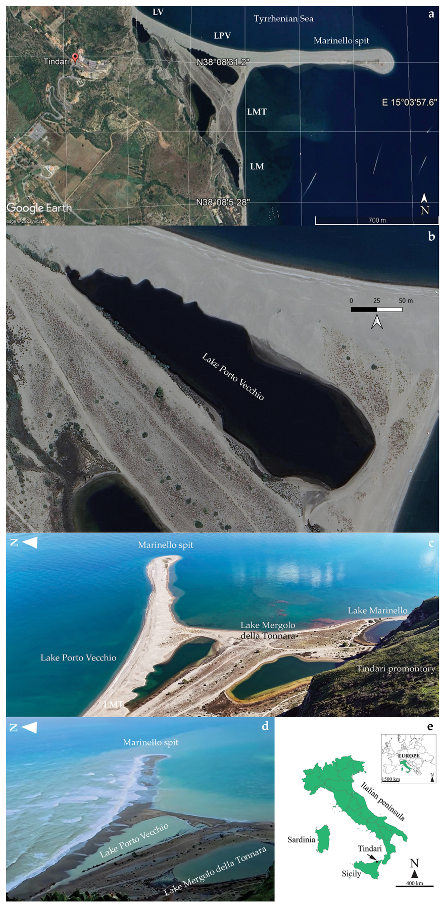
The Oliveri–Tindari (or Marinello) coastal lagoon system (Figure 1a–e) is stretched along the Sicilian Tyrrhenian slope of the Peloritani Mountains, in the middle of the Patti Gulf (Messina province) between Cape Calavà to the west and Cape Milazzo to the east (38°08′ N; 15°03′ E), and is an area affected by significant Holocene eustatic sea-level change and tectonic uplift [11,12]. In this area, the specific type of climate is Csa (hot-summer Mediterranean climate, according to the Köppen climate classification [13]).
This coastal lagoon system (0.3 km2) shows an approximately triangular planform. It is juxtaposed to the NNW–SSE cliff bounding the Tindari promontory to the west and ends seawards with an E–W-oriented 1 km long spit (arranged at about 50° transversely to the Tindari cliff) (Figure 1a–c). The lagoon hosts several semi-permanent, small-sized, and very shallow coastal brackish ponds (Lakes Verde, Fondo Porto, Porto Vecchio, Mergolo della Tonnara, and Marinello, Figure 1a) stretched parallel to the Tindari cliff. These ponds are aligned close to the cliff, except LPV, which is seawards on the back of the spit and is most influenced by marine processes (Figure 1d).
Lake Porto Vecchio is a shallow brackish coastal basin separated from the Tyrrhenian by a mobile sandy barrier. Its limited depth (<4 m) inhibits stable thermal stratification, resulting in frequent wind-driven mixing of the water column. Consequently, the lake is best classified as a warm polymictic system, characterized by recurrent vertical circulation and marked physical–chemical variability linked to intermittent marine influence and atmospheric forcing.
The regional hydrogeological and coastal management framework subdivides the coastline into 21 Coastal Physiographic Units (CPUs), delimited by headlands. Each CPU represents an independent sedimentary cell in which littoral drift processes occur with negligible sediment exchange across adjacent units. According to recent investigations conducted within the PRCEC project [14], these units are hierarchically classified into four orders (I–IV) based on their geomorphological and hydrodynamic characteristics. Within this classification, the coastal sector extending from Cape Tindari to Cape Milazzo is identified as a third-order CPU. In this unit, the net sediment littoral drift is parallel to the Tyrrhenian coast and eastwards.
In the study coastal lagoon system, a discontinuous belt (~600 m long), comprising thick and well-cemented Holocene beachrocks, occurs along the sea shoreline, extending seawards to 1.50 m and 2.50 m isobaths [15]. This belt, partially covered by beach and marine sediments, shows decimeter-thick well-cemented beds, weakly dipping seawards (10°) [15].
Lake Porto Vecchio is the largest of the Oliveri–Tindari ponds, with a perimeter and surface of ~0.810 km and ~0.02 km2, respectively (Figure 1). The pond has an elongated triangular shape, oriented NW–SE. The maximum length and width are 348 and 106 m, respectively. The pond’s minimum distance from the sea ranges from 45 (south of the spit) to 51 m (north of the spit, Figure 1c). This pond is markedly brackish and separated from the sea by a sand bar, where indirect seawater inflows may occur through infiltration or high waves during storms (Figure 1d) [1,16]. The Mediterranean Sea typically has very small tidal amplitudes (~0.1–0.3 m) [17]. Consequently, the tidal range may be in the order of a few centimeters/decimeters in the study microtidal pond. The effective tidal range inside the lake is strongly damped, and is often indistinguishable from wind-driven or barometric water-level changes.

2.2. Geological and Structural Setting of the Peloritani Mountains

The Tindari headland is formed by the tectono-stratigraphic units of the Peloritani thrust belt within the Calabria–Peloritani Arc [18]. In the study area, the chain consists of five tectono-stratigraphic units. These are, from base to top of the thrust belt: the Longi–Taormina unit, the Fondachelli unit, the Alì–Montagnareale unit, the Mandanici–Piraino unit, and the Aspromonte unit (including the Mela unit at its base). These units mainly consist of Variscan basement rocks and Meso-Cenozoic sedimentary successions, although the Aspromonte unit lacks sedimentary cover and the Alì–Montagnareale unit lacks a Variscan basement. The rocks belonging to the Aspromonte, Mandanici–Piraino, and Alì–Montagnareale units were also affected by Alpine metamorphism before their tectonic emplacement [18,19,20].
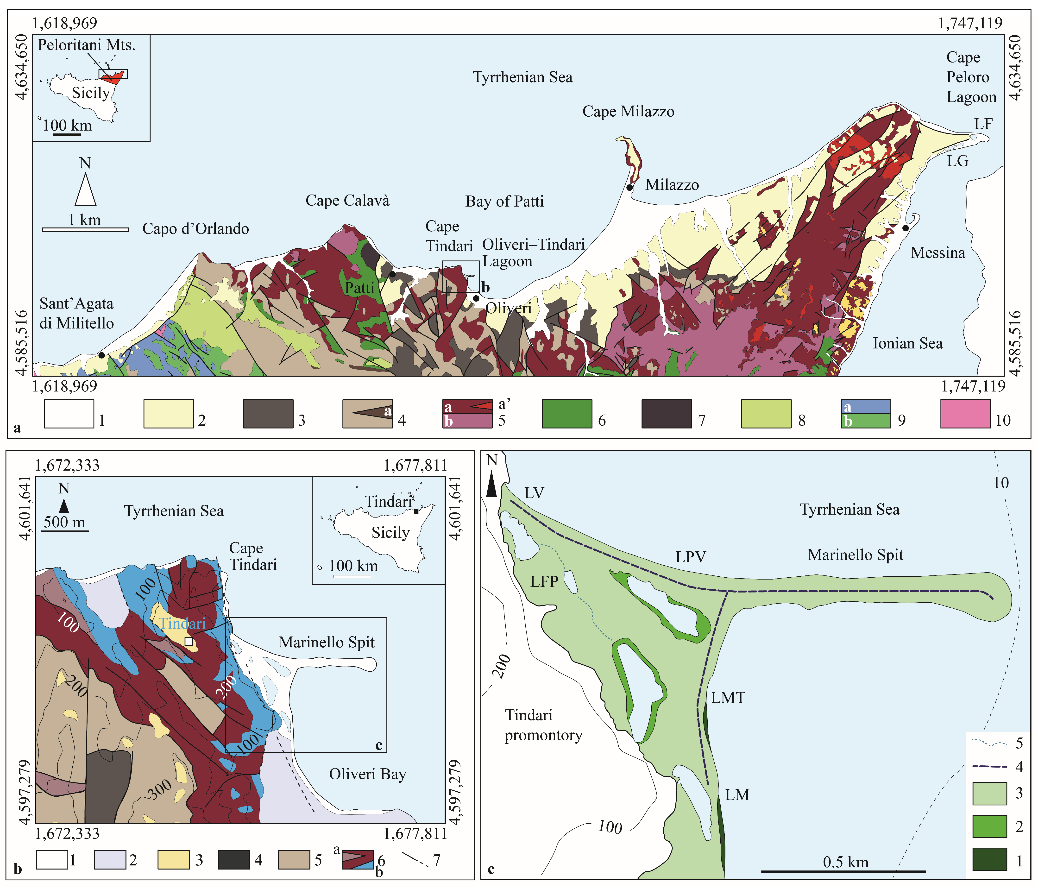
The promontory of Tindari is primarily composed of Paleozoic rocks affected by Variscan high-grade metamorphism, covered by the upper Oligocene–Burdigalian Capo d’Orlando Formation and the Upper Cretaceous–Paleogene Antisicilide Complex [18,19,20] (Figure 2a–c).
These metamorphic rocks are composed of gneiss and gneissic micaschists with meter to decameter thick layers of marble, intensively crossed by pegmatite and aplite dykes (Aspromonte unit) [18,19], and extensively exposed along the cliffs bounding the Tindari promontory (Figure 2b). Pliocene–Pleistocene NE–SW- and NW–SE-oriented normal and strike-slip faults deeply affect the area [21] (Figure 2a,b). The beach and the spit, facing the Tindari promontory N–S cliff, are characterized by fine-grained gravel and very coarse- to coarse-grained sand, mostly comprising quartz and metamorphic lithoclasts (greenish chlorite-bearing phyllites, wine-red to purple metarenites and metapelites) [15].

2.3. Holocene Coastal Evolution of the Peloritani Mountains

The Northeastern Sicilian coast facing the Ionian and Tyrrhenian seas has been shaped by the interplay of eustatic sea-level changes and tectonic uplift throughout the Holocene [11,12,22,23]. Geological and geomorphological evidence, including raised marine notches, uplifted shorelines, and remnants of paleo-beach deposits several meters above present sea level, indicates net uplift since mid-Holocene times (~5–6 ka) related to extensional tectonics affecting the Calabria–Peloritani Arc [11,12,22,23].
Along the Ionian coast, marine notches around Taormina and Cape Sant’Alessio, dated to ~5 ka, correspond to a mid-Holocene sea-level quasi-stillstand. Subsequent uplift, estimated at ~1–2 mm yr−1, progressively raised these features above present sea level [11,12,22,23]. At Cape Schisò, three paleo-shorelines (∼1.6–5 m a.s.l.) constrained by radiocarbon dating record repeated uplift events during the last ~5 ka, reflecting both gradual and episodic deformation of the Peloritani chain linked to offshore normal-fault activity [11,23].
On the Tyrrhenian side, marine notches around Cape Tindari record a comparable Holocene uplift history. Geomorphological surveys have identified a sequence of tidal notches carved into coastal cliffs (composed of calcareous marbles of the Aspromonte unit), generally occurring between ~2 and 6 m above present mean sea level. These features are interpreted as wave-cut notches formed during the mid-Holocene sea-level highstand or stillstand (~5–6 ka) recognized across the Mediterranean basin [11]. Their morphology, characterized by laterally continuous undercut grooves and associated shore platforms, suggests prolonged shoreline stability interrupted by discrete uplift events. Elevation data indicate that the highest preserved notch likely formed during the mid-Holocene stillstand and was subsequently uplifted several meters, whereas lower notches and partially submerged erosional features may reflect younger stillstands or minor relative sea-level oscillations. The inferred vertical displacement is consistent with uplift rates of ~1–2 mm yr−1, comparable with estimates from nearby Ionian coastal sectors [11,12,22,23].
Overall, the preservation of raised shoreline markers, along both the Ionian and Tyrrhenian margins, indicates a coherent tectonic signal related to the extensional tectonics affecting the Calabria–Peloritani Arc. Offshore normal faults associated with the opening of the Southern Tyrrhenian basin and the tectonic evolution of the Strait of Messina are likely to control the observed coastal uplift. The Cape Tindari notch sequence, therefore, complements evidence from Taormina, Cape Sant’Alessio, and Cape Schisò, indicating that Holocene coastal evolution in Northeastern Sicily reflects the combined effects of the mid-Holocene eustatic highstand and persistent tectonic uplift punctuated by episodic co-seismic movements [11,12,22,23].
Among markers of the shoreline, beachrocks may provide valuable indicators of former sea levels. Beachrocks are indeed lithified coastal deposits composed of beach sediments rapidly cemented by carbonate precipitation (aragonite and calcite) during episodes of relative sea-level stability. Cementation typically occurs in the intertidal to shallow subtidal zone through physicochemical and biogeochemical processes involving mixing of marine and meteoric waters, CO2 degassing, and possible microbial mediation [24,25,26,27,28]. In tectonically active Mediterranean settings such as Northeastern Sicily, beachrocks may form at former sea shoreline positions and, if subsequently uplifted, preserve evidence of past sea levels and tectonic movements, complementing marine notches and terraces as paleo-sea-level markers.

3. Materials and Methods

3.1. Sampling Stations

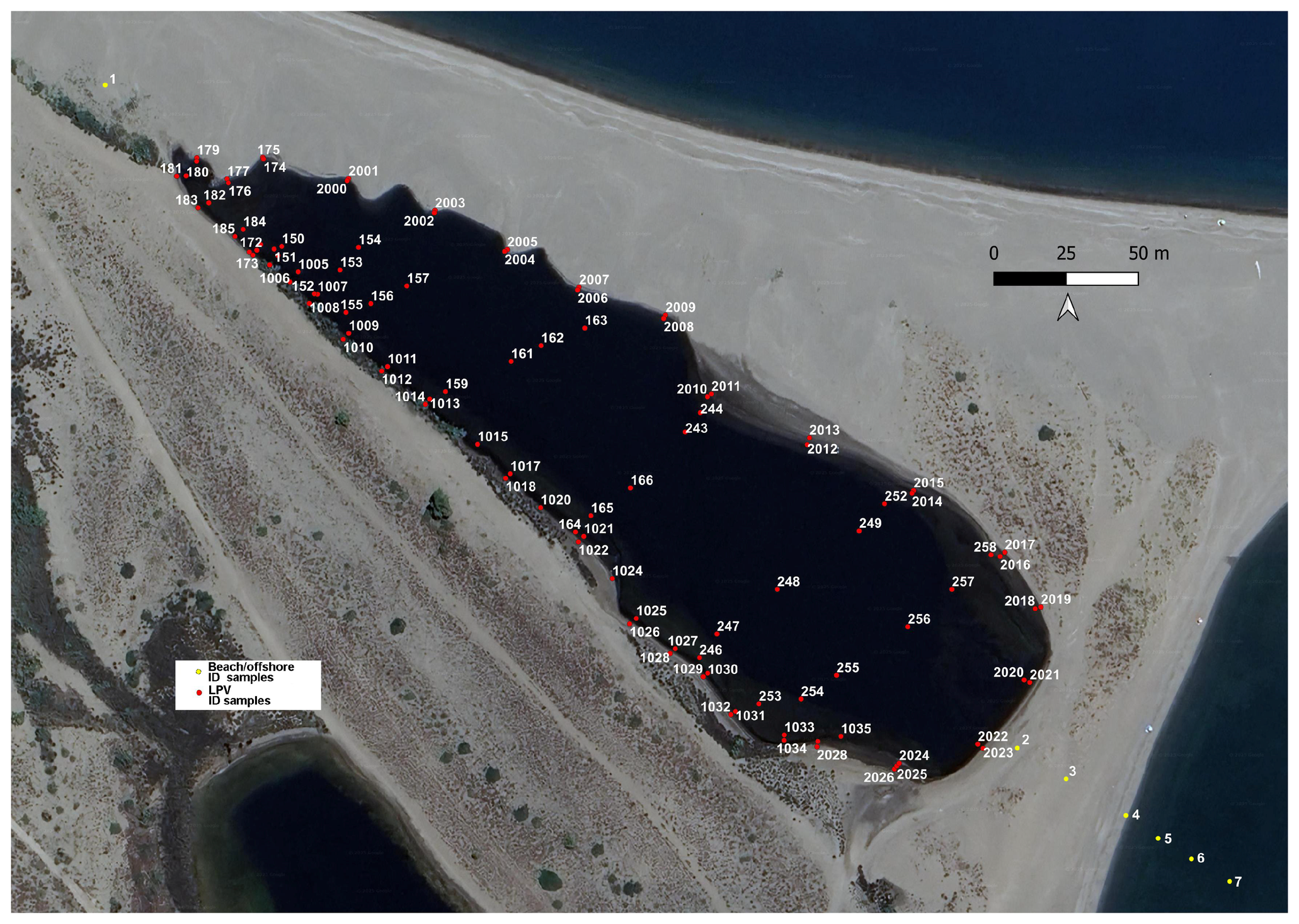
A total of 115 samples were collected from the LPV, including the surrounding onshore and shallow sea offshore areas (Figure 3).
In total, 108 samples were collected from the LPV’s actual bottom bed (Figure 3) at depths ranging from 0 to 3.5 m. Three of them were not reported on the map due to unreadable ID numbers or missing coordinates. A total of 80 samples were collected as paired shoreline samples. In the paired sample, one was sampled on the pond shore, and the other was at 0.3 m from the coastline, at ~0.3 m depth. The sample pairs were distributed with a linear spacing between two subsequent pairs of samples, ranging from ~6.5−10 m (along the southwestern coast) to ~10−25 m (along the northeastern coast) (Figure 3). In addition, 20 samples were taken from the pond’s deeper areas of the basin and distributed along six main NE–SW-oriented transects, spaced at a distance of ~60 m (Figure 3). Four sediment samples, stretched along a NW–SE-oriented transect crossing LPV, were taken from the beach (samples 1–4, NE and SE of LPV); the other three were collected from the shallow bottom sea at depths ranging from 0 to 5 m (samples 5–7, Figure 3).

3.2. Field Work, Scuba Diving Survey, Sediment Sampling, and Sample Pre-Treatments

A subaqueous survey was conducted to visually detect the pond and sea floor and collect sediment samples. The operator was equipped with a GPS for georeferencing sampling sites and tools for collection activities. Depth values were measured using a graduated cable connected to a float. The shoreline was set as the 0 m reference level.
Sampling was carried out in summer 2025 using a systematic grid with approximately 30–50 m spacing across the basin. Sediment samples were collected from the actual shallow bottom bed of LPV to perform textural and mineralogical analyses. The specimens onshore and along the pond shore at water depths < 0.5 m were taken manually by using a metal shovel (weight around 1 kg). The samples from the pond’s deeper bottom were collected during scuba diving activities by using a metal box sampler (weight around 100 g). Samples were stored in labeled plastic bags and preserved in a portable refrigerator with refrigerated packs until their storage in the laboratory freezer.
The samples to be analyzed were pre-treated with 30% hydrogen peroxide to reduce the organic matter content. These were also treated with a solution of sodium hexametaphosphate to enhance mud disaggregation and avoid flocculation. An aliquot for all the sediment samples was preserved for future chemical analyses.

3.3. Particle Size and Petrographic Analyses

The particle size analysis of the unconsolidated sediments was performed using two techniques: mechanical sieving and laser diffraction granulometry.
The mechanical sieving method was carried out for the coarse sediments (i.e., particles coarser than 4 phi). Sieving was conducted in wet conditions due to the presence of mud. The instrument used was a mechanical sieve (Retsch, model AS2, Haan, Germany). Sieves were certified by Retsch. The sieve pile comprised 12 sieves (−4.2, −3.6, −3.2, −2.7, −2.2, −2.0, −1, 0, 1, 2, 3, 4 phi).
Sediments passing to the 4 phi sieve, i.e., fine sediments, were analyzed by means of a laser diffraction granulometer. This method provides cumulative and frequency curves and allows classification of fine sediments [29]. The method is based on the light-scattering principle. Accordingly, the volume of an irregular particle is considered equivalent to that of a sphere, the particle size is inversely proportional to the diffraction angle of a laser beam, and the number of particles depends on the intensity of the diffracted beam [29,30]. The instrument used was a diffraction particle size analyzer (Malvern Panalytical, model Mastersizer 2000, Malvern, UK) equipped with a dispersion unit (Hydro MU) in liquids. Sediments were analyzed in wet conditions (distilled water). The particle diameter range was 0.02–2000 µm.
Textural statistical parameters (mean, median, sorting/standard deviation, skewness, kurtosis), cumulative curves, and classifications were elaborated or calculated by using spreadsheets elaborated by the authors (Excel software, version 2021). The combined use of mechanical sieving and the laser diffraction method data was based on the use of percentage values of both mass and volume distributions and the application of different orders of proportions. The main textural statistical parameters were calculated according to Folk and Ward’s formula [8] (see Supplementary Materials Table S1).
Petrographic observations focused on grain composition, fabric, cement type, and diagenetic features to identify lithification processes, depositional conditions, and source areas. Selected representative sediment specimens of sands and cemented rocks of LPV and beach sediments were examined using a binocular stereomicroscope equipped with transmitted light (Zeiss, SteREO Discovery.V20 model, Oberkochen, Germany). Samples were also consolidated in epoxy resin to obtain thin sections for observation under a polarizing optical microscope (Zeiss, Axio Imager 2 model, Oberkochen, Germany). The cements of the coherent rocks of LPV were analyzed under a SEM-EDS (Scanning Electron Microscopy coupled to X-ray Energy Dispersive Spectrometer). The system was composed of a SEM (ThermoFisher, Inspect s50 model, Waltham, MA, USA), working at 10 kV and 1 nA of probe current, coupled to a spectrometer (Bruker, Quantex X Flash 6q/60 EDS, Billerica, MA, USA).

3.4. Data Elaboration

The textural parameters (mean, median, sorting, skewness, and kurtosis) were plotted in bivariate and multivariate diagrams [31] using spreadsheets developed by the authors with Microsoft Excel (version 2021). The textural parameters were also represented, for their visualization, in georeferenced 2D maps, e.g., [32] performed by applying a kriging interpolation algorithm in QGIS open-source software (3.28 Firenze version) [9,10] with a grid resolution of ~5–10 cm. The contour lines of the bathymetric map were obtained by applying the triangulation method, opportunely modified according to onsite morphological observations.
Bivariate and multivariate plots were based on a dataset including the textural data related to LPV integrated with data from ten samples collected on the beach and shallow seabed of the Oliveri–Tindari Bay for comparative purposes. A total of 73 specimens from previous research on Lakes Faro and Ganzirri of the Cape Peloro lagoon [9,10] were also included in the plots for comparative purposes.

4. Results

4.1. Morpho-Bathymetric Map

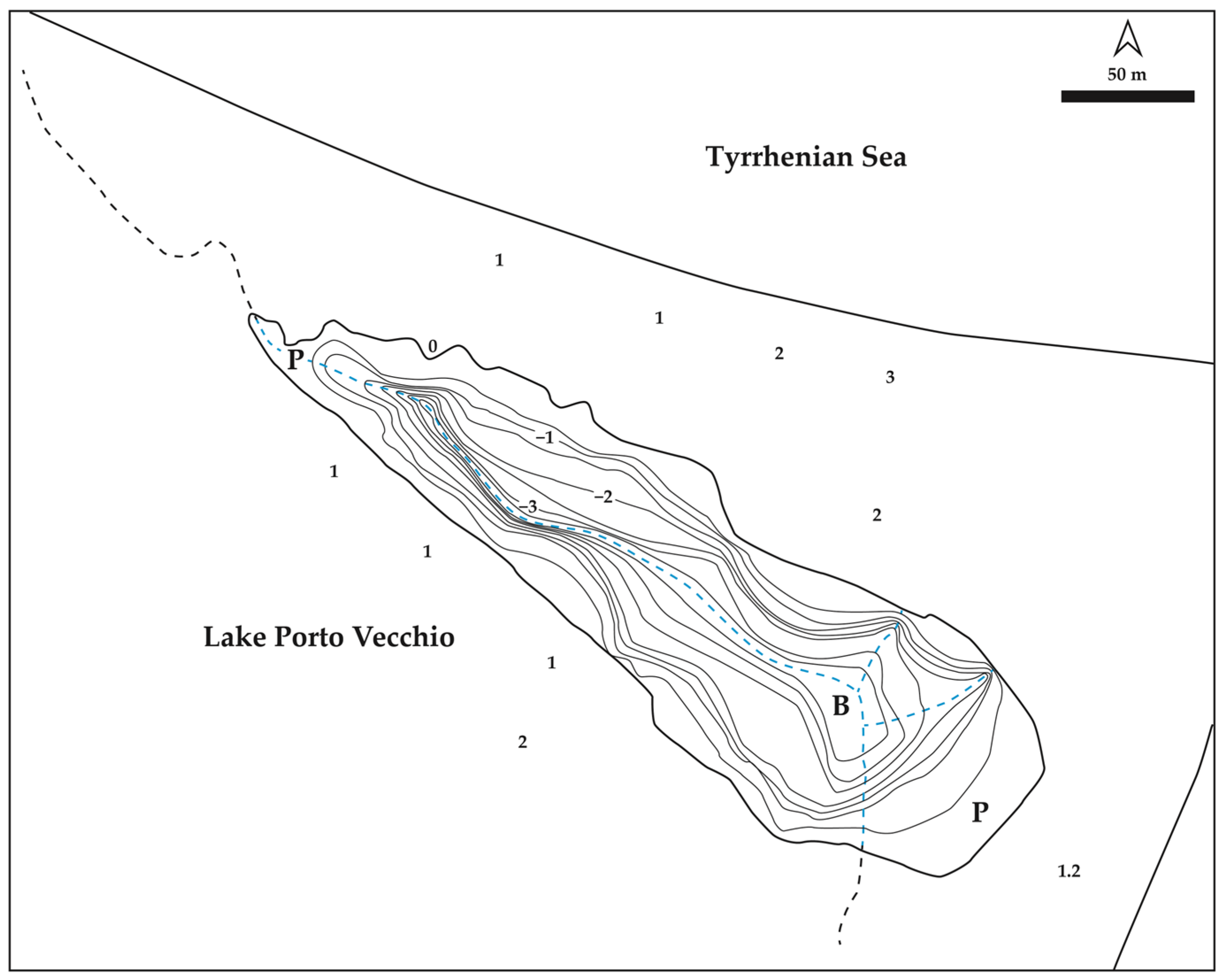
The morphology of the pond bottom was characterized by relatively steep slopes in contrast to a sub-horizontal platform identified at shallow depths along most of the pond coastline (Figure 4). The platform indeed extends continuously from NW to SE (in an anticlockwise sense), with a width ranging from a few meters to a few decameters (Figure 2c and Figure 4). Depths were very shallow along the platform (<0.5–1 m) and reached a maximum depth of 3–3.5 m in the basin depocenter (Figure 4).

4.2. Particle Size Analyses

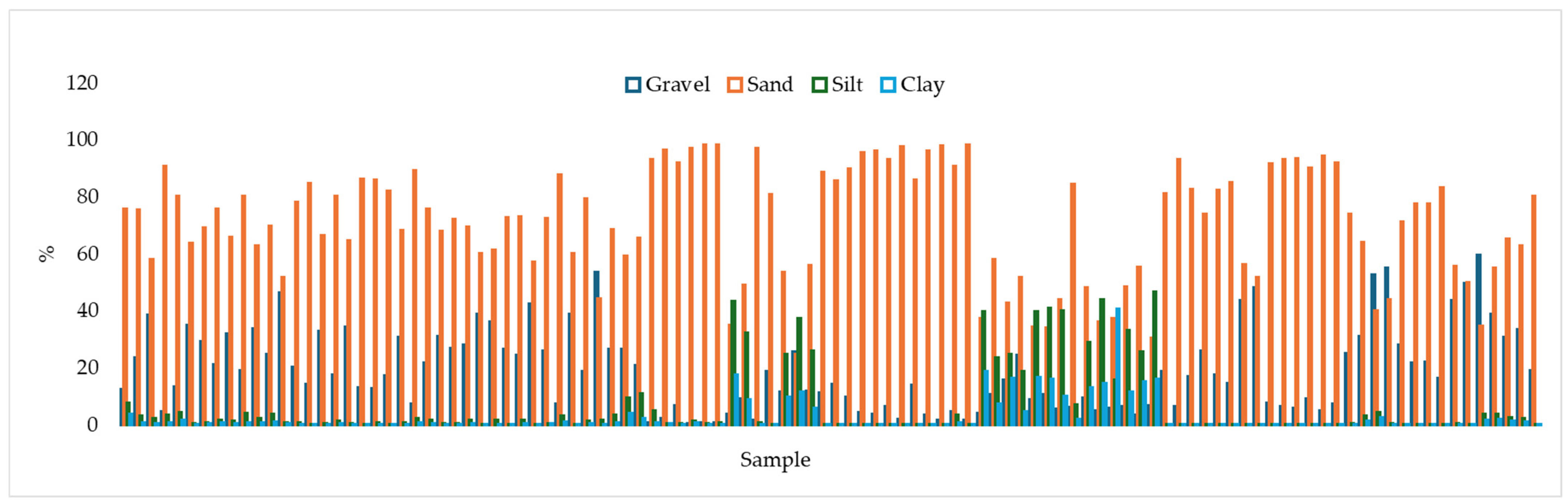
The plot in Figure 5 synthesizes the four endmembers (gravel, sand, silt, clay) identified in the sediments from LPV using mechanical sieving and laser diffraction methods. Most of the samples consist of gravelly sand (83%) (Figure 5 and Figure 6). Muddy samples (silt prevailing) represent only 17% of the samples (Figure 5 and Figure 6).
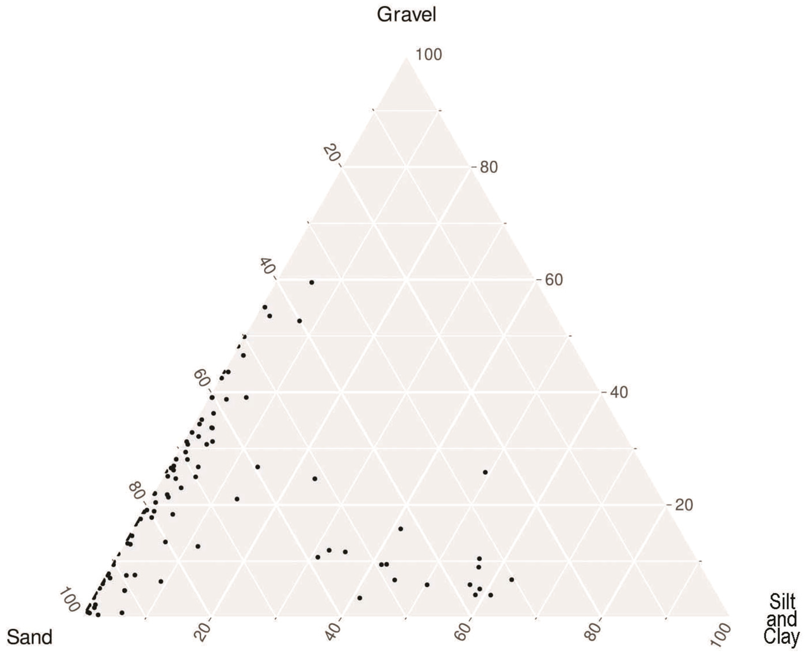
The ternary diagram gravel–sand–mud (silt and clay) (Figure 6) shows the presence of two main groups of deposits: (1) sandy to gravelly, and (2) sandy to muddy sediments. The first group, mostly located along the axis of sand–gravel with a few scattered samples (on the right) enriched in mud, comprised samples from the shallowest LPV areas. The second one, mainly distributed in the lowermost central area along the axis of sand and mud, with a few scattered samples (on the top) enriched in gravel, comprised samples from the deepest LPV areas.

4.3. GIS Maps of the Statistical Textural Parameters

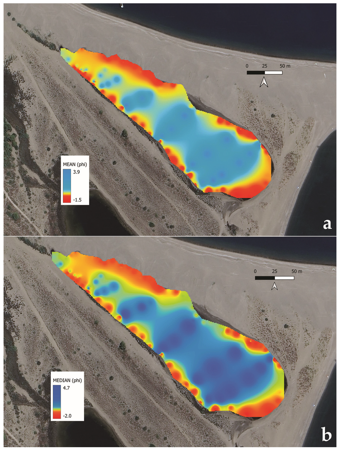
Mean and median—the georeferenced distribution of the sediment grain size (mean and median) is reported in Figure 7a,b. Grain size ranges from gravel to fine-grained sand and coarse silt (Figure 7a,b). Gravel occurs sporadically along the shoreline. Very coarse-grained sand is distributed along the shore and at shallow depths. Very fine-grained sand and coarse-grained silt (Figure 7) are present in the central and deepest area of the basin, passing through a transitional pattern from coarse-medium- to fine-grained sand (Figure 7). Grain size shows a general fining trend (i.e., coarse to fine sediments) towards the depocenter and toward the SE (Figure 7).
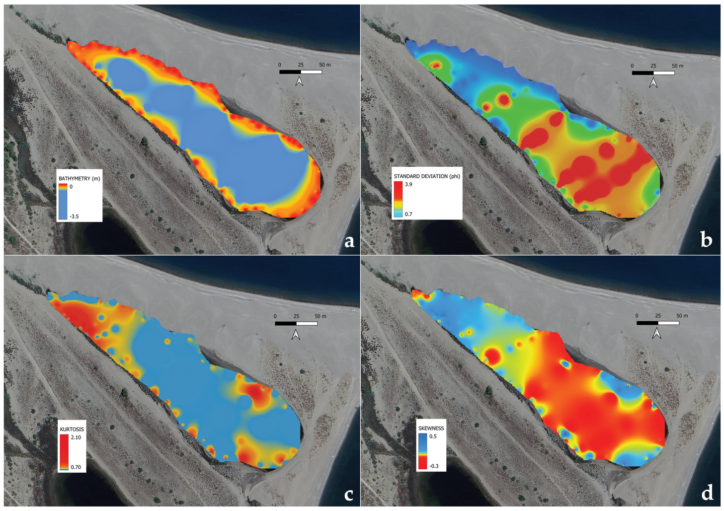
Figure 8a shows the GIS elaboration of the pond bathymetry (Figure 8a).
The georeferenced distribution of the sediment statistical textural data (standard deviation/sorting, kurtosis, skewness) are reported in Figure 8b–d.
Standard deviation (σ: 0.7–3.9 phi, Figure 8b)—the standard deviation is characterized by a poor sorting mean value. The values present an increasing gradient towards the SE, varying from moderately well sorted on the NW pond bottom to extremely poorly sorted on the SE part of the basin.
Kurtosis (KG: 0.7–2.1, Figure 8c)—sediments show kurtosis values ranging from platykurtic (in a few sites on the bottom center) to leptokurtic and very leptokurtic (in a few sites along the shore). Mesokurtic sediments are locally present on the pond bottom.
Skewness (Sk: −0.3–0.5, Figure 8d)—sediments range from coarse- (on the central to SE bottom) to strongly fine-skewed (on a few sites along the southern shore). Symmetrically finely skewed sediments are widespread on the pond bottom, whereas fine-skewed sediments are concentrated on the NW edge of the bottom and along the shore of the SE side.
The distribution of the analyzed statistical textural parameters is reported in the Supplementary Materials (Figure S1).

4.4. Petrographic Analyses

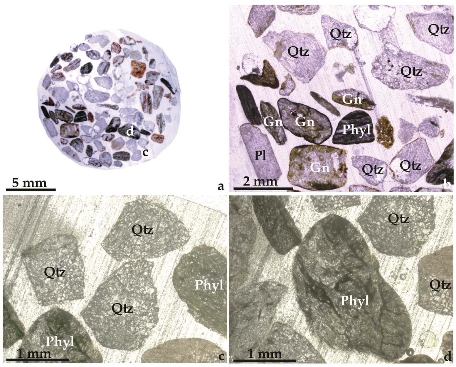
The sediments collected in LPV and the surrounding area (beach and sea offshore) consist of both unconsolidated and weakly cemented siliciclastic deposits, characterized by rounded to sub-angular clasts of metamorphic lithoclasts with a minor percentage of metasedimentary rocks. Sediments mostly comprise grains of quartz, phyllites, and gneiss (belonging to the Mandanici and Aspromonte units; Figure 9a–d) and Verrucano-type metarenite and metasiltite (belonging to the Alì–Montagnareale unit).
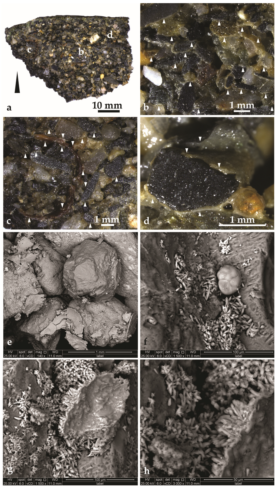
Weakly cemented deposits are well-bedded in sub-horizontal and 4–5 cm thick, fining-upwards beds (Figure 10a). Sediments are highly porous and clast-supported (Figure 10b–d). Cementation is heterogeneous. Cements are carbonate and mostly consist of a few 10 µm thick rinds encasing clastic particles (Figure 10b–e,g) and local meniscus cement at the grains’ contact. Preliminary crystal morphology analyses on cements indicate that they are mostly composed of carbonate acicular (Figure 10f,g), needle-like, and rosette-shaped crystals (Figure 10h). EDS spectra (Ca: 32.15; O: 32.15; C: 0; Mg: 0.07; Si: 6.41) showed that cements may consist of aragonite and low-magnesian calcite (LMC). Notwithstanding, further investigations, based on cathodoluminescence and spectroscopic analytical methods, are necessary and in progress to better discriminate such mineral phases.
Actual benthic organisms, such as brown bivalves (Figure 10c), foraminifers (Figure 10f), and ostracods, are also present in these sediments.

5. Discussion

5.1. Evolution of the Lake Porto Vecchio

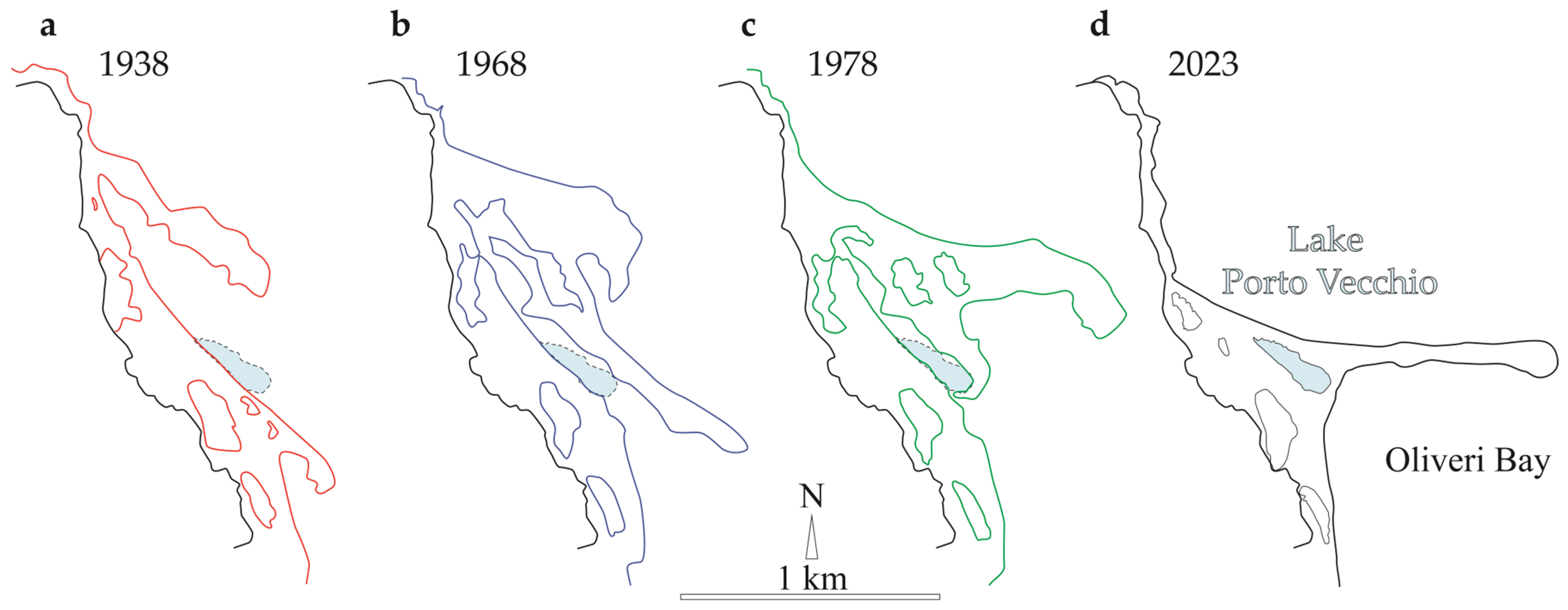
The Oliveri–Tindari lagoon system represents a relatively young coastal environment developed during the late stages of Holocene coastal evolution along the Tyrrhenian margin of Northeastern Sicily. Historical documentation and multi-temporal aerial imagery indicate that the lagoon–spit system formed during approximately the last 150–200 years because of enhanced sediment supply and persistent longshore drift directed eastwards along the coast. Progressive spit growth promoted the development of several small and shallow coastal ponds whose morphology and connectivity have changed repeatedly in response to storms, shoreline migration, and episodic barrier breaches (Figure 11a–d) [1,2,15,33,34,35,36,37,38]. Despite the high morphological mobility of the spit and adjacent shoreline sectors, bathymetric comparisons between historical surveys and the present data suggest that the central sector of Lake Porto Vecchio has remained remarkably stable over the past decades, notwithstanding the volume of the pond being strongly reduced (Figure 11c). Maximum depths measured in earlier investigations (~3.4 m in 1981) [1] are comparable to those obtained during the present survey (~3.5 m), indicating negligible vertical change in the basin depocenter. This persistence suggests that, although marginal zones of the lagoon undergo frequent reconfiguration, the central part of the basin acts as a relatively stable accommodation where fine-grained sediments accumulate. Such behavior is typical of wave-dominated microtidal lagoons in which barrier mobility and over wash processes mainly affect marginal sectors, whereas internal basins function as low-energy sediment traps. In this framework, LPV exhibits a dual character: highly dynamic margins controlled by coastal processes and a comparatively stable central depocenter that preserves a coherent sedimentary record.

5.2. Geological and Sedimentological Mapping of Lake Porto Vecchio

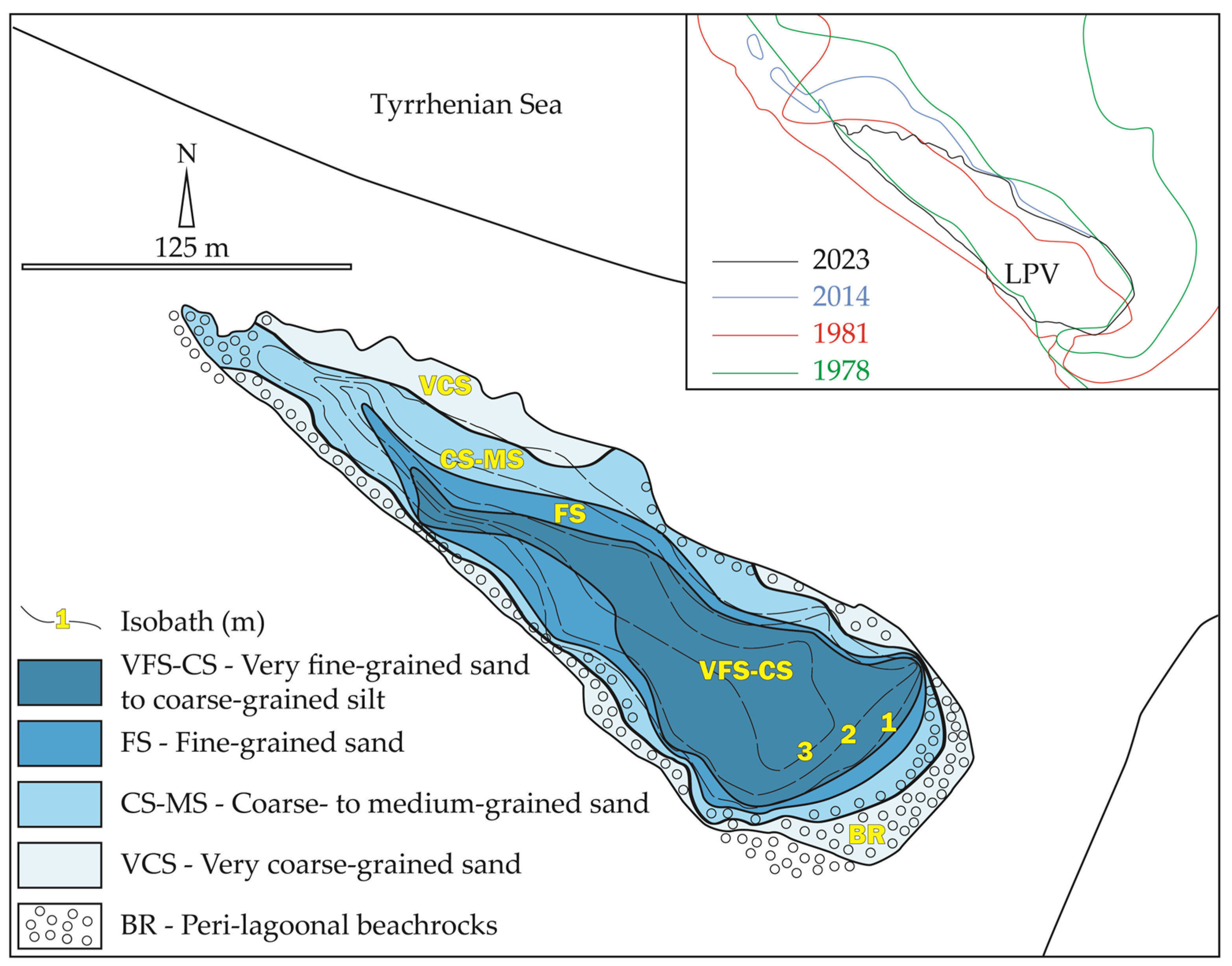
The spatial distribution of grain-size parameters (Figure 7) reveals a well-organized sedimentary pattern (Figure 12). Coarse sediments, including gravelly sands and very coarse-grained sands, dominate the shallow marginal zones (Figure 12) where wave action, wash over, e.g., [39], and shoreline reworking are most effective. In contrast, the deeper central basin is characterized by finer sediments composed mainly of fine-grained sand and subordinate silt (Figure 12). This systematic grain-size transition reflects progressive attenuation of hydrodynamic energy from the shoreline toward the depocenter. In the shallow marginal platform (<1 m depth), wave agitation and episodic storm events favor winnowing of fine particles and the concentration of coarse sediment fractions. Conversely, in deeper sectors of the pond, energy becomes sufficiently weak to allow settling of finer particles transported in suspension. Sorting patterns further support this interpretation. Moderately to poorly sorted sediments occur predominantly along the marginal platform, where repeated sediment reworking produces mixing of grain populations. Toward the basin center, the predominance of finer sediments and reduced energy conditions favor the accumulation of relatively more homogeneous deposits. The resulting sedimentary architecture is therefore characterized by a concentric textural organization broadly parallel to the shape of the basin. Such a pattern is typical of confined coastal lagoons where bathymetry and physical gradients exert a primary control on sediment distribution, e.g., [2,40]. The observed sedimentation patterns likely developed after the closure of the inlet in 1978 (Figure 11c and Figure 12).
One of the most significant results of this research is the identification of variously cemented sediments along the LPV and the sea shoreline (Figure 2c). The partially and weakly cemented sediments by carbonate may be interpreted as actual beachrocks, whose genesis may be hypothesized post 1978, i.e., subsequent to the closure of the basin (Figure 11c). This beachrock forms a shallow sub-horizontal platform, up to 10–20 m wide (maximum width: ~18 m) and with sub-horizontal bedding, surrounding most of the margins of LPV (Figure 12). These beachrocks occur at depths generally shallower than 1 m and locally are exposed onshore along the pond shoreline. Bed thickness appears to be increasing toward the SE, ranging from a few centimeters (on the NW platform) to a few decimeters (on the SE platform). Analogously, the cementation grade also varies from very low to medium, according to the same NW to SE spatial trend.
The analyzed beachrock carbonate cements, likely aragonitic, with possible subordinate low-Mg calcite, together with the peculiar morphology of acicular, needle-like, and rosette-shaped crystals, are highly compatible with early marine carbonate cements. The studied beachrocks represent an earlier phase of shoreline stabilization preceding the modern configuration of the pond. Although its precise age remains unconstrained by absolute dating, the beachrock platform likely formed during an earlier stage of lagoon evolution during the 70s–80s time span, before the present configuration of the basin. The presence of this partially lithified marginal platform exerts a strong influence on modern sediment dispersal within the coastal pond. The platform acts as a morphological barrier that modifies local hydrodynamics and promotes the retention of coarse sediments along the lagoon margins. At the same time, it favors the preferential transport and accumulation of finer particles toward the central basin, where hydrodynamic conditions are weaker. Consequently, the present-day sedimentary architecture of LPV results from the interaction between active depositional processes and peri-lagoonal inherited structures. This relationship highlights the importance of morphological inheritance in controlling sediment distribution in shallow and small coastal lagoons, as recently observed also in the Lakes Ganzirri and Faro of the Cape Peloro lagoon [9,10].
Preliminary data devoted to the beachrocks exposed along the sea shoreline of the Tindari area (Figure 2c) indicate that these are very different from the peri-lagoonal ones of LPV and LMT (Figure 2c), being strongly cemented, thicker, and presumably older (at least one century old).

5.3. Grain-Size Statistical Analysis and Environmental Discrimination

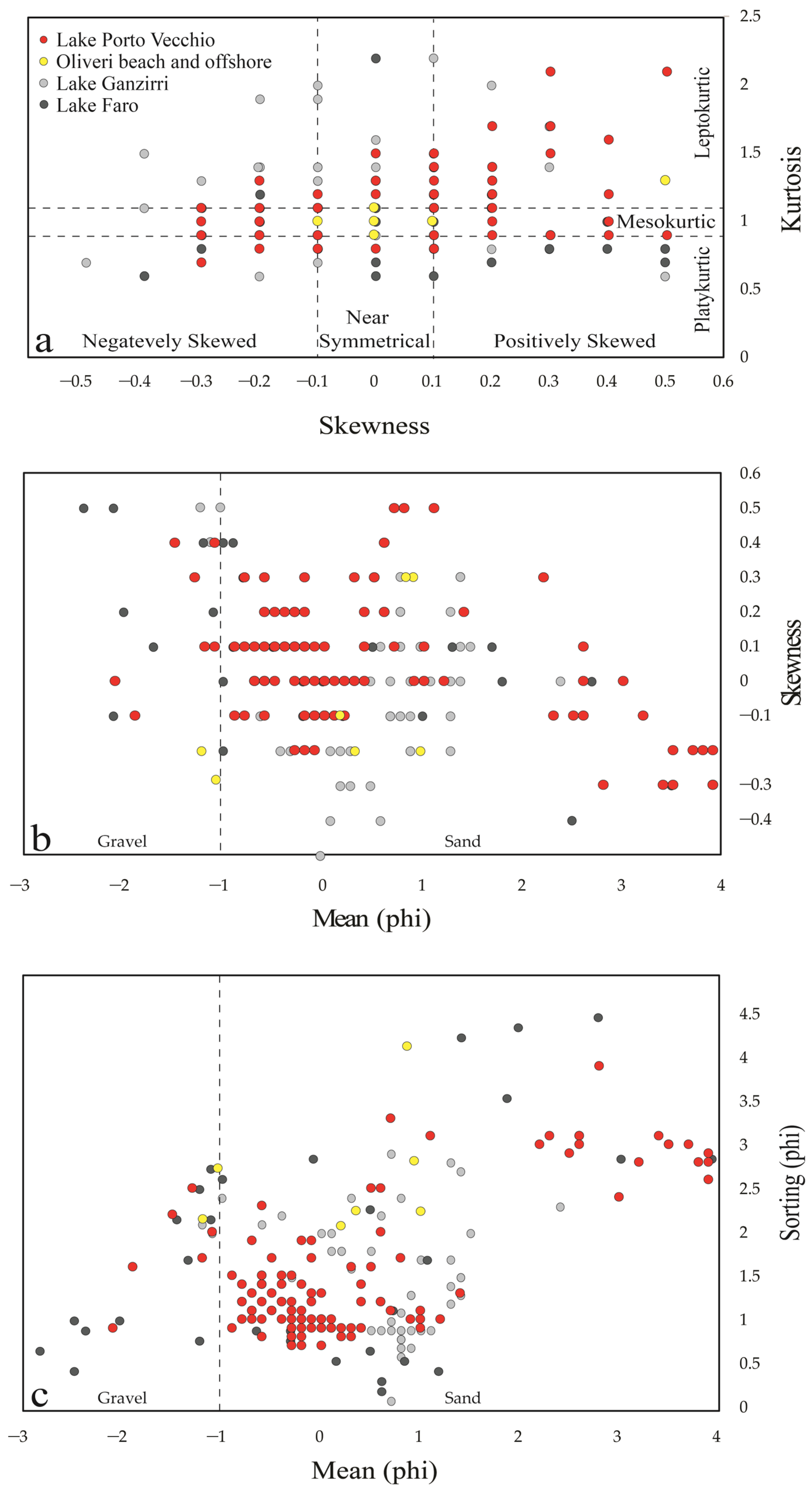
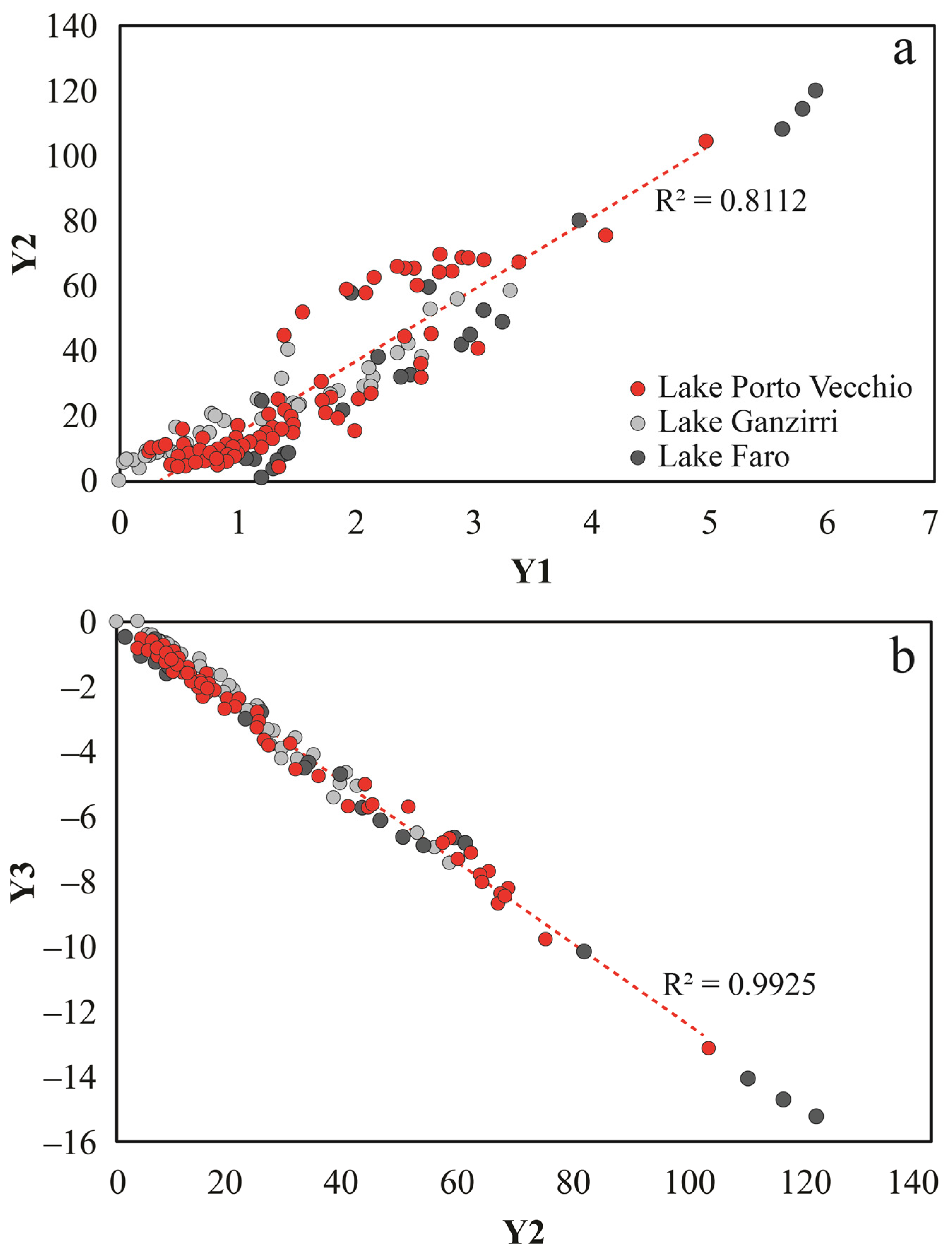
Grain-size statistical parameters provide additional insight into sediment transport mechanisms and depositional environments within the lagoon. Bivariate relationships between mean grain size, standard deviation, skewness, and kurtosis (Figure 13) reveal a wide dispersion of sediment textures within LPV, reflecting the coexistence of multiple hydrodynamic regimes across the basin. When compared with sediments collected from the adjacent beach and shallow marine environments, notwithstanding the similar grain size, LPV deposits display a distinct statistical signature. The absence of overlap between most LPV samples and beach sediments indicates that basin confinement may modify the primary marine grain-size distribution. Multivariate discriminant diagrams (Figure 14) indicate that most samples from LPV fall within fields commonly associated with beach or shallow marine environments. Especially, the bivariate statistics demonstrate that classical grain-size discrimination methods remain effective for identifying sedimentary environments even in small, modern ones. These results confirm the continued usefulness of grain-size statistical approaches originally developed for ancient siliciclastic successions [31]. When interpreted in combination with bathymetric information, such methods provide valuable tools for distinguishing coastal lake deposits from adjacent coastal facies.

5.4. Conceptual Model for Sediment Organization in Microtidal Shallow Coastal Lakes

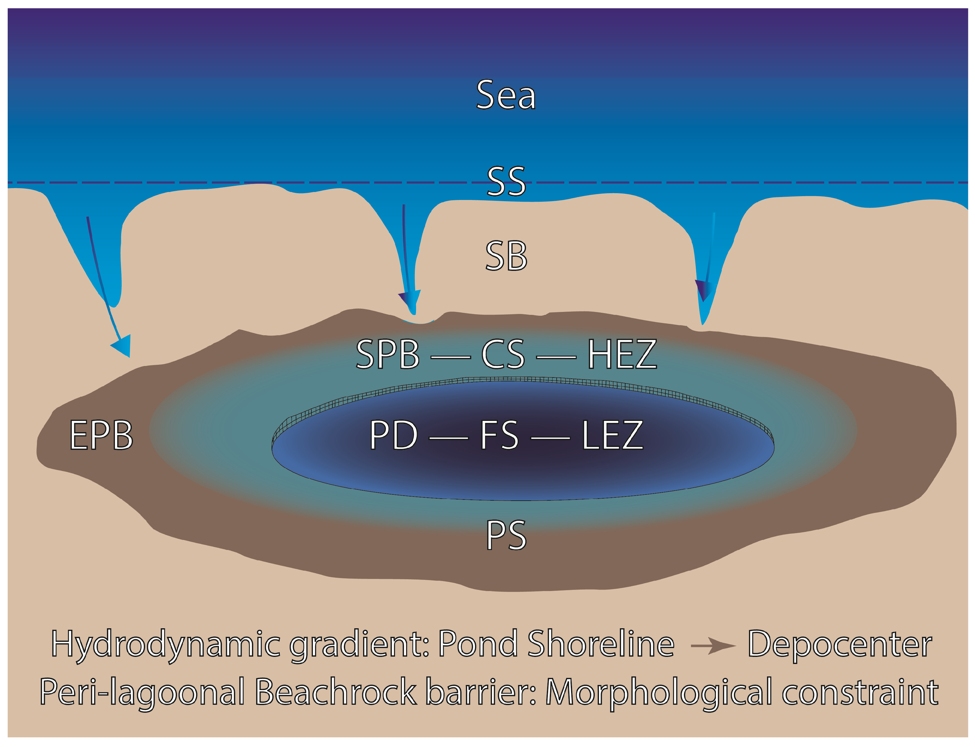
Considering the sedimentological aspects and physical processes characteristic of coastal lagoon systems [41], the combined morpho-bathymetric, sedimentological, and statistical data reported in this paper may allow the development of a conceptual model describing sediment organization within Lake Porto Vecchio (Figure 15). In this model, three main factors control sediment distribution:
i.
Hydrodynamic energy gradients, which decrease from the shoreline toward the depocenter and produce a systematic fining trend in grain size;
ii.
Basin morphology, which confines sediment transport pathways and promotes accumulation of fine material in the depocenter;
iii.
Inherited coastal structures, represented by the peri-lagoonal beachrock platform, which act as morphological constraints influencing sediment dispersal.
Figure 15. Conceptual model (plan view) for sediment organization in microtidal small and shallow coastal lakes with peri-lagoonal beachrocks. Acronyms—CS: coarse sedimentation. EPB: emerged peri-lagoonal beachrocks. FS: fine sediments. HEZ: high-energy zone. LEZ: low-energy zone. PD: pond depocenter. PS: pond shoreline. SB: sandy bar. SPB: submerged peri-lagoonal beachrocks. SS: sea shoreline. Symbols—blue arrow: winter washes over by sea storms. Barbed black line: peri-lagoonal beachrock bed termination. The sketch model is not to scale.
Quaternary 09 00039 g015
The interaction between these factors generates a characteristic concentric pattern of sediment facies, consisting of coarse marginal deposits overlying the beachrock platform and finer sediments accumulating in the deeper basin center. This model highlights how modern sedimentary architectures in small Mediterranean coastal lagoons may result from the superposition of active processes and inherited structures. Such interactions are likely common in microtidal coastal environments but remain poorly documented in the sedimentological literature [9,10]. Lake Porto Vecchio, therefore, represents a valuable modern analog for interpreting similar lagoonal deposits preserved in the Quaternary stratigraphic record, particularly where lithified coastal structures such as beachrocks influence sediment distribution and basin evolution.

6. Conclusions

This research provides new insights into sediment dispersal and depositional organization within a peculiar small Mediterranean coastal basin surrounded by a peri-lagoonal beachrock platform. The integration of morpho-bathymetric observations with sedimentological and petrographic analyses allows several conclusions to be drawn, as synthesized in the following:
i.
Sediment distribution in LPV shows a clear gradient from marginal coarse-grained sands to fine-grained basin deposits.
ii.
The beachrock platform acts as a barrier controlling sediment dispersal.
iii.
Grain-size statistical methods remain effective tools for distinguishing coastal lagoon and marine depositional environments.
iv.
The coexistence of inherited coastal structures and active depositional processes allows the development of a conceptual model in which lithified coastal platforms and coastal hydrodynamics jointly control sediment distribution.
v.
The petrographic composition of the sediments sampled in LPV and the surrounding area indicates a western source supplying sediments to the lagoonal coastal system and spit. The presence of lithoclasts derived from the erosion of Alpine anchimetamorphic Verrucano-type deposits—linked to the Alì–Montagnareale unit, which is exposed only to the west of Tindari Cape at Montagnareale (at Cape Calavà, Figure 2a)—supports this interpretation.
vi.
The study beachrocks of LPV may be considered one of the rarest and best-preserved sites where a very young peri-lagoonal beachrock (presumable age: post 1978) is identified in a coastal lake. The rarity of the LPV peri-lagoonal beachrocks further contributes to elevating the geological importance of the Oliveri–Tindari oriented natural reserve, which should justify classifying the reserve as a Mondial geosite and nominating it as UNESCO heritage.
In conclusion, the present results may contribute to the understanding of sediment organization in other analogous Mediterranean (e.g., Lake Ganzirri and Lake Faro in Southern Italy) [9,10] or extra-Mediterranean areas, such as the southern ocean coastal lagoons (e.g., Lake Butler and Lake Fellmongery in Southern Australia) [42], providing useful modern analogs for interpreting them.

Supplementary Materials

The following supporting information can be downloaded at: https://www.mdpi.com/article/10.3390/quat9030039/s1, Table S1. Main textural parameters according to Folk and Ward’s formula. Figure S1. Box plot of the grain size main statistical textural parameters. The mean values are also reported. Acronyms—SD: standard deviation/sorting (phi). KG: kurtosis. Sk: skewness. Mz: mean (phi). M: median (phi).

Author Contributions

Conceptualization, R.S.; methodology, R.S.; software, R.S., S.C. and F.P.L.M.; validation, R.S.; formal analysis, R.S.; investigation, R.S. and S.G.; data curation, R.S., S.C., A.S.P., R.K.M. and S.Z.; writing—original draft preparation, R.S.; writing—review and editing, R.S.; visualization, R.S., S.C., A.S.P., S.G., R.K.M., F.P.L.M., G.Z. and S.Z.; supervision, R.S. All authors have read and agreed to the published version of the manuscript.

Funding

This work was supported by PO FEAMP (Fondo Europeo per gli Affari Marittimi e la Pesca) 2014/2020 measure 2.5.1.

Data Availability Statement

The original contributions presented in this study are included in the article/Supplementary Materials. Further inquiries can be directed to the corresponding author.

Acknowledgments

The authors gratefully acknowledge Maria Letizia Molino (director of the Oriented Reserve of Oliveri–Tindari Lagoon, Metropolitan City of Messina) for granting sampling permission. Special thanks to Marina Morabito and her students for their kind assistance during the sampling activities. The authors wish to acknowledge Giovanni Randazzo for his constructive discussions on the research contents. Finally, the authors sincerely acknowledge the reviewers for their insightful comments and constructive suggestions, which substantially improved the manuscript. Appreciation is also extended to the Academic Editor and the Assistant Editor for their support throughout the review process.

Conflicts of Interest

The authors declare no conflicts of interest.

Abbreviations

The following abbreviations are used in this manuscript:
LPVLake Porto Vecchio
LVLake Verde
LMTLake Mergolo della Tonnata
LMLake Marinello
LGLake Ganzirri
LFLake Faro

References

  1. Crisafi, E.; Giacobbe, S.; Leonardi, M. Nuove ricerche idrobiologiche nell’area lagunare di Oliveri–Tindari (Messina): Morfologia dei bacini e caratteristiche fisico-chimiche delle acque e dei sedimenti. Mem. Biol. Mar. Oceanogr. 1981, 11, 139–186. [Google Scholar]
  2. Short, A.D. Handbook of Beach and Shoreface Morphodynamics; Wiley: Chichester, UK, 1999. [Google Scholar]
  3. Allen, J.R.L. Principles of Physical Sedimentology; George Allen and Unwin: London, UK, 1984. [Google Scholar]
  4. Boyd, R.; Dalrymple, R.; Zaitlin, B.A. Estuarine and incised-valley facies models. In Facies Models Revisited; Posamentier, H.W., Walker, R.G., Eds.; SEPM: Tulsa, OK, USA, 2006; pp. 171–196. [Google Scholar]
  5. De Pippo, T.; Donadio, C.; Pennetta, M.; Petrosino, P. Coastal hazard and sediment transport in Mediterranean environments. Geomorphology 2008, 97, 295–307. [Google Scholar] [CrossRef]
  6. Longhitano, S.G.; Della Luna, R.; Milone, A.L.; Cilumbriello, A.; Caffau, M.; Spilotro, G. The 20,000-years-long sedimentary record of the Lesina coastal system (southern Italy): From alluvial, to tidal, to wave process regime change. Holocene 2016, 26, 678–698. [Google Scholar] [CrossRef]
  7. Friedman, G.M. Distinction between dune, beach, and river sands from their textural characteristics. J. Sediment. Res. 1961, 31, 514–529. [Google Scholar] [CrossRef]
  8. Folk, R.L.; Ward, W.C. Brazos River bar: A study in grain-size parameters. J. Sediment. Petrol. 1957, 27, 3–26. [Google Scholar] [CrossRef]
  9. Somma, R.; Yazdi, M.G.; Abyat, M.; Manguerra, R.K.; Zaccaro, S.; Marra, A.C.; Giacobbe, S. Sedimentological and ecological controls on heavy metal distributions in a Mediterranean shallow coastal lake (Lake Ganzirri, Italy). Quaternary 2026, 9, 9. [Google Scholar] [CrossRef]
  10. Somma, R.; Yazdi, M.G.; Giacobbe, S. Sedimentological and geological mapping of the shallow platform and deep basin of Lake Faro (Cape Peloro Coastal Lagoon, Italy): New insights into modern sediments and Holocene beachrocks. Quaternary 2026, 9, 19. [Google Scholar] [CrossRef]
  11. Stewart, I.S.; Cundy, A.; Kershaw, S.; Firth, C. Holocene coastal uplift in the Taormina area, northeastern Sicily: Implications for the southern prolongation of the Calabrian seismogenic belt. J. Geodyn. 1997, 24, 37–50. [Google Scholar] [CrossRef]
  12. Antonioli, F.; Kershaw, S.; Rust, D.; Verrubbi, V. Holocene sea-level change in Sicily and its implications for tectonic models: New data from the Taormina area, northeast Sicily. Mar. Geol. 2003, 196, 53–71. [Google Scholar] [CrossRef]
  13. Köppen, W. Das geographische System der Klimate. In Handbuch der Klimatologie; Köppen, W., Geiger, R., Eds.; Gebrüder Borntraeger: Berlin, Germany, 1936. [Google Scholar]
  14. Regione Siciliana. Piano Regionale per il Contrasto all’Erosione Costiera (PRCEC Project). Available online: https://www2.regione.sicilia.it/deliberegiunta/file/giunta/allegati/N.290_16.07.2020.pdf (accessed on 27 March 2026).
  15. Somma, R.; Gatì, I.A.; Giacobbe, S. Inventory and quantitative assessment of coastal geoheritage: Contribution to the proposal of an active geomorphosite. Geosciences 2025, 15, 125. [Google Scholar] [CrossRef]
  16. Mazzola, A.; Bergamasco, A.; Calvo, S.; Caruso, G.; Chemello, R.; Colombo, F.; Giaccone, G.; Gianguzza, P.; Guglielmo, L.; Leonardi, M.; et al. Sicilian transitional waters: Current status and future development. Chem. Ecol. 2010, 26, 267–283. [Google Scholar] [CrossRef]
  17. van Haren, H. Tidal motions in the deep Mediterranean. arXiv 2026, arXiv:2601.03771. [Google Scholar] [CrossRef]
  18. Bonardi, G.; Giunta, G.; Liguori, V.; Perrone, V.; Russo, M.; Zuppetta, A. Schema geologico dei Monti Peloritani. Boll. Soc. Geol. Ital. 1976, 95, 49–74. [Google Scholar]
  19. Lentini, F.; Catalano, S.; Carbone, S. Carta Geologica della Provincia di Messina (1:50,000); SELCA: Florence, Italy, 2000. [Google Scholar]
  20. Somma, R. The inventory and quantitative assessment of geodiversity as strategic tools for promoting sustainable geo-conservation and geo-education in the Peloritani Mountains (Italy). Educ. Sci. 2022, 12, 580. [Google Scholar] [CrossRef]
  21. Ghisetti, F. Evoluzione neotettonica dei principali sistemi di faglie della Calabria centrale. Boll. Soc. Geol. Ital. 1979, 98, 387–430. [Google Scholar]
  22. Scicchitano, G.; Spampinato, C.R.; Ferranti, L.; Antonioli, F.; Monaco, C.; Capano, M.; Lubritto, C. Uplifted Holocene shorelines at Capo Milazzo (NE Sicily, Italy): Evidence of co-seismic and steady-state deformation. Quat. Int. 2011, 232, 201–213. [Google Scholar] [CrossRef]
  23. Spampinato, C.R.; Scicchitano, G.; Ferranti, L.; Monaco, C. Raised Holocene paleo-shorelines along the Capo Schisò coast, Taormina: Evidence of recent co-seismic deformation in northeastern Sicily. J. Geodyn. 2012, 55, 18–31. [Google Scholar] [CrossRef]
  24. Kelletat, D. Beachrock as sea-level indicator? Remarks from a geomorphological perspective. J. Coast. Res. 2006, 22, 1558–1564. [Google Scholar] [CrossRef]
  25. Vousdoukas, M.I.; Velegrakis, A.F.; Plomaritis, T.A. Beachrock occurrence, characteristics, formation mechanisms and impacts. Earth-Sci. Rev. 2007, 85, 23–46. [Google Scholar] [CrossRef]
  26. Mauz, B.; Vacchi, M.; Green, A.; Hoffmann, G.; Cooper, A. Beachrock: A tool for reconstructing relative sea level in the far-field. Mar. Geol. 2015, 362, 1–16. [Google Scholar] [CrossRef]
  27. Danjo, T.; Kawasaki, S. Characteristics of beachrocks: A review. Geotech. Geol. Eng. 2014, 32, 215–246. [Google Scholar] [CrossRef]
  28. Łukawska-Matuszewska, K.; Rzepa, G.; Brodecka-Goluch, A.; Borkowski, A.; Gebus-Czupyt, B.; Błachowski, A.; Manecki, M.; Kania, J.; Dwornik, M.; Radzikowska, M. Biogeochemical controls on carbonate dynamics driven by methane and freshwater inputs in shallow sediments of a brackish continental shelf sea. EGUsphere 2026. preprint. [Google Scholar] [CrossRef]
  29. Blott, S.J.; Pye, K. Particle size distribution analysis of sand-sized particles by laser diffraction. Sedimentology 2004, 51, 245–263. [Google Scholar] [CrossRef]
  30. Eshel, G.; Levy, G.J.; Mingelgrin, U.; Singer, M.J. Critical evaluation of the use of laser diffraction for particle-size distribution analysis. Soil Sci. Soc. Am. J. 2004, 68, 736–743. [Google Scholar] [CrossRef]
  31. Sahu, B.K. Depositional mechanisms from the size analysis of clastic sediments. J. Sediment. Petrol. 1964, 34, 73–83. [Google Scholar]
  32. Fedra, K.; Feoli, E. GIS technology and spatial analysis in environmental studies. Comput. Environ. Urban Syst. 1988, 12, 181–196. [Google Scholar]
  33. Abbruzzese, D.; Aricò, F. Osservazioni geomorfologiche e fisico-chimiche sui laghi di Oliveri-Tindari. Boll. Pesca Piscic. Idrobiol. 1955, 10, 1–23. [Google Scholar]
  34. Amore, C.; Giuffrida, E.; Zanini, A. Evoluzione temporale e dinamica litorale dell’area lagunare di Oliveri-Tindari (Messina). Boll. Accad. Gioenia Sci. Nat. 1991, 24, 117–131. [Google Scholar]
  35. Di Natale, R.; La Loggia, G. Analisi dell’evoluzione della costa prospiciente Capo Tindari ai fini della conservazione dei laghetti di Marinello. In Proceedings of the Convegno Problemi Ambientali e Tecnologie Avanzate, Palermo, Italy, 21–23 February 1991. [Google Scholar]
  36. Randazzo, G.; Geremia, F.; Lanza, S. Temporal evolution of Tindari headland spit and Marinello coastal wetland system (NE Sicily). In Proceedings of the Lagoons and Coastal Wetlands in the Global Change Context: Impacts and Management Issues, Venice, Italy, 26–28 April 2004. [Google Scholar]
  37. Crisà, A.; Lanza, S.; Randazzo, G. The historical evolution of the Tindari–Marinello spit (Patti, Messina, Italy). In Sand and Gravel Spits; Randazzo, G., Jackson, D., Cooper, J., Eds.; Coastal Research Library; Springer: Cham, Switzerland, 2015; Volume 12, pp. 103–121. [Google Scholar] [CrossRef]
  38. Leonardi, M.; Bergamasco, A.; Giacobbe, S.; Azzaro, F.; Cosentino, A.; Crupi, A.; Crisafi, E. A four decades multiparametric investigation in a Mediterranean dynamic ecosystem: Mollusc assemblages answer to environmental changes. Estuar. Coast. Shelf Sci. 2020, 234, 106625. [Google Scholar] [CrossRef]
  39. Schwartz, R.K. Bedform and stratification characteristics of some modern small-scale washover sand bodies. Sedimentology 1982, 29, 835–849. [Google Scholar] [CrossRef]
  40. Davis, R.A., Jr.; Fitzgerald, D.M. Beaches and Coasts; John Wiley & Sons: Hoboken, NJ, USA, 2009. [Google Scholar]
  41. Ward, L.G.; Ashley, G.M. Physical processes and sedimentology of siliciclastic-dominated lagoonal systems. Mar. Geol. 1989, 88, 181–354. [Google Scholar] [CrossRef]
  42. Swainson, I.P. The structure of monohydrocalcite and the phase composition of the beachrock deposits of Lake Butler and Lake Fellmongery, South Australia. Am. Mineral. 2008, 93, 1014–1018. [Google Scholar] [CrossRef]
Figure 1. The Oliveri–Tindari (or Marinello) coastal lagoon and spit. (a) Satellite imagery of the oriented natural reserve of Oliveri–Tindari, east of the Tindari promontory (year 2023, Google Earth Pro), with its main ponds. (b) Detail of the satellite imagery (a) showing Lake Porto Vecchio. (c) UAV imagery of part of the lagoon (summer 2024). (d) UAV imagery of part of the lagoon during an exceptional winter storm (13 February 2026). (e) Localization of the study area in the Italian territory. Abbreviations: LV, Lake Verde; LPV, Lake Porto Vecchio; LMT, Lake Mergolo della Tonnata; LM, Lake Marinello.
Quaternary 09 00039 g001
Figure 2. Geological maps of the Oliveri–Tindari lagoon at various scales. (a) Geological and structural sketch map of the Tyrrhenian slope of the Peloritani Mountains. The black empty square indicates the study area. In the insert at the top left, the black empty rectangle indicates the northernmost sector of the Peloritani Mountains on the Sicily map. (1) Alluvial and coastal deposits (Actual). (2) Clastic, carbonate, and evaporitic rocks (Miocene–Pleistocene). (3) Floresta Calcarenites Fm (Serravallian–Langhian) and Antisicilide Complex (Upper Cretaceous–Paleogene). (4) Stilo Capo d’Orlando Fm with olistoliths (a) (upper Oligocene–Burdigalian). (5) Aspromonte unit (Paleozoic)—gneiss and micaschists (a) intruded by aplo-pegmatites, granitoids, and augen gneiss (a’), and with marbles (b). (6) Mandanici–Piraino unit (Paleozoic to Mesozoic). (7) Alì–Montagareale unit (Permo–Triassic to Cretaceous). (8) Fondachelli unit (Paleozoic to Mesozoic). (9) Longi–Taormina unit—Mesozoic–Cenozoic cover (a) and Paleozoic basement (b). (10) Maghrebid Flysch basin (Upper Jurassic–Lower Miocene). (b) Detail of Figure 2a: Geological sketch map of Cape Tindari promontory. (1) Beach deposits (Actual). (2) Alluvial and coastal deposits (Holocene). (3) Marine and Fluvial terraces (Quaternary). (4) Antisicilide Complex (Upper Cretaceous). (5) Stilo Capo d’Orlando Fm (Oligocene–Burdigalian). (6) Aspromonte unit—gneiss and micaschists with layers of augen gneiss (a) and marbles (b) (Paleozoic). (7) Fault (uncertain with dotted line; Upper Pliocene–Pleistocene to Actual). (c) Detail of Figure 2b: Geological sketch map of the Oliveri–Tindari lagoon and Marinello spit. The cliff of the promontory bounding the lagoon is reported in white. Abbreviations: LV, Lake Verde; LFP, Lake Fondo Porto; LPV, Lake Porto Vecchio; LMT, Lake Mergolo della Tonnata; LM, Lake Marinello. (1) Sea beachrocks (Holocene). (2) Peri-lagoonal beachrocks (Actual) in the LPV and LMT. (3) Gravelly to sandy beach deposits (Actual). (4) Coastal bar. (5) Canal among ponds.
Quaternary 09 00039 g002
Figure 3. Lake Porto Vecchio and the surrounding area. Map with localization of the sediment samples. Dataset: 105 samples from the LPV (solid red dot); samples (solid yellow dot) along a NW–SE transect from onshore (4 samples, NW and SE of LPV) to offshore (3 samples).
Quaternary 09 00039 g003
Figure 4. Morpho-bathymetric map of Lake Porto Vecchio showing the presence of a very shallow platform (P) along the shore surrounding the basin (B) area. Isobath spacing: −0.5 m; elevation onshore (m a.s.l.). Dataset: 105 depth measurement stations. Black dotted line: Exhumed, previous channels connecting to other ponds and the sea. Light-blue dotted line: presumed LPV hydrographic pattern.
Quaternary 09 00039 g004
Figure 5. Histograms showing the gravel, sand, silt, and clay percentages related to the LPV sediment samples. Dataset: 108 samples.
Quaternary 09 00039 g005
Figure 6. Ternary diagram gravel–sand–silt-and-clay showing the sediment classification of the LPV sediment samples (solid black dot). Dataset: 108 samples.
Quaternary 09 00039 g006
Figure 7. Grain-size textural parameter map showing spatial distribution of central tendency parameters: (a) mean grain size (phi) and (b) median grain size (phi). Dataset: 105 measurement stations. The sign “-“ corresponds to the minus sign.
Quaternary 09 00039 g007
Figure 8. Spatial distribution maps of bathymetry and grain-size statistical parameters: (a) bathymetry (m); (b) standard deviation (phi); (c) kurtosis; (d) skewness. Dataset: 105 measure stations. The sign “-“ corresponds to the minus sign.
Quaternary 09 00039 g008
Figure 9. Microphotographs of a sediment specimen included in epoxy resin (sample LPV 1018). (a) Sandy clasts of metamorphic rocks under a stereomicroscope with transmitted light. (b) Sandy clasts of quartz, gneiss, phyllites, and feldspar under a stereomicroscope with transmitted light. (c) Sandy clasts of quartz and phyllites observed under a petrographic microscope (PPL). (d) Sandy clasts of quartz and phyllites under a petrographic microscope (PPL). Abbreviations: PPL, plane polarized light. Qtz: Quartz. Phyl: Phyllites. Gn: Gneiss. Pl: Plagioclase.
Quaternary 09 00039 g009
Figure 10. Microphotographs of a fresh-faced specimen of partially cemented sediments. (a) Oriented bed of moderately cemented sediments, ~4 cm thick, fining upward with gravelly to sandy particles from base to top. The uppermost horizontal surface is the bedding plane. (b) Rounded clasts of metamorphic rocks surrounded by a carbonate rim of isopachous fringes. (c) Brownish bivalve shell with clasts of metamorphic rocks, surrounded by a carbonate rim of isopachous fringes. (d) Clasts of metamorphic rocks surrounded by a carbonate rim of isopachous fringes. Symbols—small white triangle: indicator of cement rim. (ad) Observations were under a stereomicroscope. (e) Remains of carbonate cement around the grains. (f) Acicular fibers. A benthic foraminifer is also evident. (g) Carbonate rim of isopachous fringes of acicular crystals. (h) Needle-like and rosette-shaped crystals. (eh) Observations were under a SEM–EDS.
Quaternary 09 00039 g010
Figure 11. Lake Porto Vecchio in the context of the evolution of the Oliveri–Tindari lagoon during the time interval between 1938 (a), 1968 (b), 1978 (c), and 2023 (d).
Quaternary 09 00039 g011
Figure 12. Geological–sedimentological map of Lake Porto Vecchio showing modern unconsolidated sediment and peri-lagoonal beachrock distribution. Isobaths are also reported. In the upper-right inset, a detailed framework of the LPV evolution during the 1978–2023 time span (Figure 11). For the site localization, see Figure 2.
Quaternary 09 00039 g012
Figure 13. Bivariate plots. (a) Skewness versus kurtosis. (b) Mean versus skewness (c) Mean versus sorting. Symbols are reported in (a). Lake Porto Vecchio sample (solid red circle). Beach and shallow marine sediments from the Oliveri–Tindari beach (solid yellow circle), Lake Ganzirri (solid light gray circle), and Lake Faro (solid dark gray circle) samples were also reported for comparative purposes.
Quaternary 09 00039 g013
Figure 14. Lake Porto Vecchio (solid red circle) multivariate plots between discriminant functions: (a) Y1 vs. Y2. (b) Y2 vs. Y3. Sediments from the other two coastal lakes (Lake Ganzirri, solid light gray circle; and Lake Faro, solid dark gray circle) of the Cape Peloro lagoonal system were also reported for comparative purposes.
Quaternary 09 00039 g014
Disclaimer/Publisher’s Note: The statements, opinions and data contained in all publications are solely those of the individual author(s) and contributor(s) and not of MDPI and/or the editor(s). MDPI and/or the editor(s) disclaim responsibility for any injury to people or property resulting from any ideas, methods, instructions or products referred to in the content.