Article

Paleoenvironments of the Last Interglacial–Glacial Transition on the East European Plain: Insights into Climate-Driven Ecosystem Dynamics

1
Department of Botany, University of Wisconsin-Madison, Birge Hall, 132, 430 Lincoln Dr, Madison, WI 53706, USA
2
Boryssyak Paleontological Institute RAS, Profsoyuznaya Str., 123, Moscow 117647, Russia
3
Institute of Geography RAS, Staromonetny Lane, 29, Moscow 119017, Russia
4
A.N. Severtsov Institute of Ecology and Evolution, Leninsky Prospect. 33, Moscow 119071, Russia
5
Koltzov Institute of Developmental Biology RAS, ul. Vavilova 26, Moscow 119334, Russia
6
Institute of Earth Sciences, Saint-Petersburg State University, 7-9, Universitetskaya Nab., St. Petersburg 199034, Russia
7
Department of Cartography, Moscow State University of Geodesy and Cartography, Gorokhovy Line, 4, Moscow 105064, Russia
8
Department of Biology, Moscow State Lomonossov University, Ulitsa Kolmogorova, 1-12, Moscow 119234, Russia
9
Department of Geography, University of Ottawa, 60 University, Ottawa, ON K1N 6N5, Canada
*
Author to whom correspondence should be addressed.
These authors contributed equally to this work.
Quaternary 2025, 8(4), 66; https://doi.org/10.3390/quat8040066
Submission received: 22 July 2025 / Revised: 22 October 2025 / Accepted: 4 November 2025 / Published: 11 November 2025

Abstract

A multiproxy study of a new Pleistocene locality at Ivantzevo, Moscow Region, was conducted to reconstruct paleoenvironments from the Middle Pleistocene to the Last Pleniglacial. Lacustrine deposits and peat accumulated in a wetland within a fluvioglacial depression formed during the Dnieper–Moscow glaciation. Silts and clays were deposited during MIS 7 and the Moscow (Saale) Glaciation (MIS 6), while peat accumulation began in the Mikulino (Eemian) (MIS 5e). The wetland persisted for approximately fifty millennia, until the Middle Valdai (Weichselian). Interglacial peat deposits contain well-preserved pollen and macrofossils, and the recovered fossil insect assemblage is unique for European Russia. Chronology was established using multiple OSL and 230Th/U dates, combined with pollen-based correlations to type sections north and west of the region. The reconstructed ecosystem dynamics are divided into eleven stages. The transition from the last interglacial to the second stadial of the Valdai involved seven phases: (1) expansion of boreal spruce forest, (2) spread of thermophilic broad-leaved forests with hazel, (3) development of open forest–steppe ecosystems with groves of deciduous trees, (4) re-establishment of forest cover with birch and, later, mixed pine, spruce, and birch forests, (5) emergence of cold steppe combined with shrub-dominated tundra, (6) return of boreal spruce forest, and (7) abrupt replacement of forest by cold steppe and shrub tundra. Climatic reconstructions indicate that these ecosystem dynamics closely corresponded to changes in precipitation and aridity.

Graphical Abstract

1. Introduction

The transition from the Eemian interglacial (LI) to the Weichselian glacial (LG) climate is of special interest in the context of ecosystem adaptation to ongoing climate change, as it provides a model of rapid climatic transitions not influenced by human activity. The Eemian interglaciation was warmer than the present [1], with warming driven by orbital changes. While the orbital changes at the end of the last interglacial were similar to the modern ones [2], they caused short-term climate warming rather than continuous cooling. Thus, short events of unstable transitional climate-environment systems can help evaluate the extent to which human activity may affect climate.
The Eemian-Weichselian transition is well studied in Western Europe [3,4,5,6]. These studies show that the climate curve was saw-like, and while temperature decline was commonly observed, some northern regions remained considerably warm in the early Weichselian [7]. Such local anomalies could be caused by maritime influences; therefore, inland sites in the central part of the East European Plain can provide a simpler model of climatic changes. However, such sites are not numerous, and many were studied in the 1970s and 1980s, before some modern techniques of sediment dating and analysis became available. Correlation of discovered deposits with specific isotope stages is still predominantly based on palynological analysis e.g., [8,9,10].
In Europe, the most detailed paleo-reconstructions are based on studies of Pleistocene deposits in varved lakes. In European Russia, comparable resolution can be achieved mainly by studying buried lacustrine deposits and peat. Recently, several stratigraphic sequences have been studied in detail in northern regions of Russia, near the southern extent of the Valdai glaciation [11,12,13,14,15,16,17]. The southernmost extent of the Eemian (Mikulino) peat deposits on the East European Plain lies within the mixed forest vegetation zone (Figure 1a). This area is of particular interest, as it could provide a missing link between the well-established European chronology of the last IGL/LGL transition, based on studies of “living” lakes in the forest zone, and the Russian chronology, based on paleopedological studies in the forest-steppe zone [18,19,20,21,22].
A new Pleistocene locality, Ivantzevo (Figure 1b), was recently discovered in a gravel pit within the Klin-Dmitrov Ridge [25,26]. The stratigraphic sequence features lacustrine deposits overlain by thick gyttja and peat units, where insects, seeds, grass stems, wood, spores, and pollen are well preserved. Peat often provides the best preservation, and the most complete record of plant and invertebrate remains [26,27,28,29,30]. Our preliminary analysis highlighted the excellent quality of the Ivantzevo paleo-archive. The stratigraphic sequence was laterally and vertically extended after the preliminary analyses, exposing new depositional units.
Several outcrops of Mikulino lacustrine and peat deposits have been documented previously within the Klin-Dmitrov Ridge, north of Moscow: Kunya River near Zagorsk, Spass-Kamenetsky gravel pit near Iksha, and a gravel pit near Borisovo, in the vicinity of Dmitrov [30,31,32,33,34]. The locality nearest to our site is Borisovo (Borisova Gora), where a peat bed approximately 10 m thick was studied. The age of the peat was established as Mikulino (MIS 5e) solely based on the presence of pollen from broad-leaved trees [30]. However, a thermoluminescence (TL) date of 123 ± 7 ka [34], corresponding to the Mikulino age, was obtained from a sand layer beneath the peat, while the peat itself was not tested. Until now, none of the localities within the Klin-Dmitrov Ridge have been analyzed in detail using modern dating methods.
In this study, we applied a range of modern analytical techniques to examine the new Pleistocene locality-a buried lake that persisted under changing climate conditions and preserved traces of aquatic and adjacent terrestrial ecosystems. Our aim was to reconstruct climate-ecosystem interactions during the transition from the Last Interglacial to the Last Pleniglacial.

2. Regional Setting

The section is situated on the outskirts of the town of Dmitrov in the Moscow Region, in the northern part of the Klin-Dmitrov Ridge (Figure 1). Boulder, gravel, and sand deposits of the lateral zone of the Moscow glaciation (MIS 6) are mined in numerous quarries around Dmitrov, and these temporary exposures help to clarify and enhance the geological record of the region [35,36,37,38].
The bedrock consists of Cretaceous sand and sandstone, with locally reworked Cretaceous rocks commonly occurring within gravel beds. In some parts of the area, loosely packed Cretaceous sand deposits are affected by erosion. The study section is in an outwash terrain, a large drainage valley filled with glacial–lacustrine and glacial–fluvial deposits.
In the summer of 2020, we discovered a peat unit in a new exposure within a large gravel pit between Borisovo village and Ivantzevo railway station [25,26] (Figure 1b); the section was designated “Ivantzevo” (56°19′06.6″ N, 37°33′16.2″ E; elevation 173 m).

3. Materials and Methods

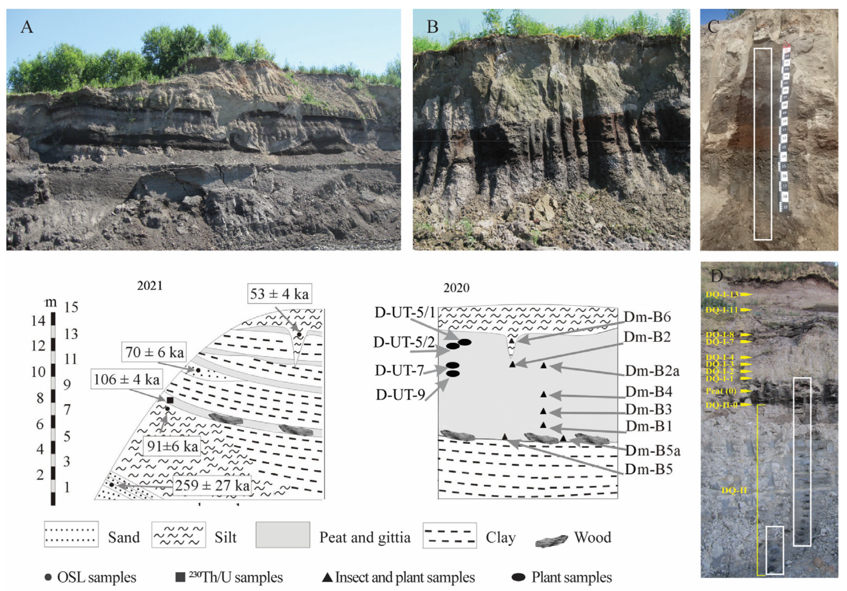
In the following year, further development of the quarry exposed a different part of the peat unit, which was divided into several peat beds interspersed with clays (Figure 2) and underlain by a deeply exposed sand bed. Excavations were conducted in a salvage mode within a tight time frame, as the peat exposure was scheduled to be destroyed by developers.
The outcrops were sampled twice, in 2020 and 2021, as the stratigraphic sequence exposed by the 2021 excavations was deeper and more complex. Standard lithological analyses, such as grain size analysis and loss on ignition, were carried out for the portion of the outcrop exposed in 2020 [26]. Preliminary palaeobiological analyses were also conducted on the 2020 section [26] and have been complemented in this study by additional analyses of samples from the 2021 section.

3.1. Stratigraphy and Sampling

The Ivantzevo outcrop exposed a suite of laminated peat and peat-like deposits up to 8 m thick, overlying lacustrine deposits, which are underlain by alluvial sand and, deeper still, glaciofluvial gravelly sand. The peat suite is overlain by gleied clayey silt. The stratigraphy of the outcrop suggested either a Mikulino (Eemian) or Early Valdai (Weichselian) age for the peat unit. In the following text, these two stages are referred to as Mikulino and Valdai, following regional stratigraphic nomenclature.
A detailed geological description of the outcrop is provided in [26,37]; here, we describe only the general stratigraphy relevant to sampling.
The 16-m-thick outcrop comprises six main units, described from bottom to top (Figure 2 and Figure 3):
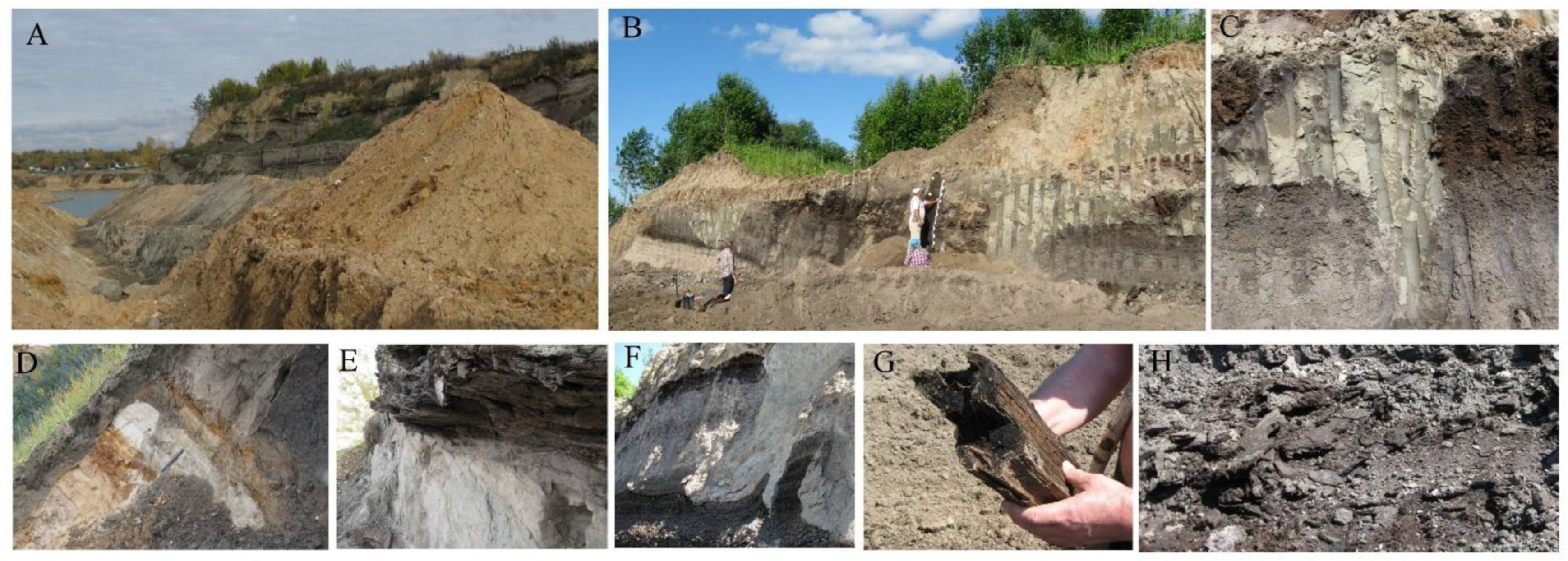
1. Sand. The sand unit consists of two facies: a glaciofluvial facies of brown gravelly sand at the base of the outcrop (>4.7 m) and an alluvial facies of yellow, brown, and white laminated sand layers (4.7–3.6 m) (Figure 3A,D).
2. Grey silt/grey clay. Lacustrine deposits of grey sandy silt contain sublayers of grey clay and, locally, gyttja (Figure 3F). The thickness of the unit exceeds 4 m in the middle and is approximately 3 m at the left edge of the outcrop. On the right side, grey clay overlies sand at the same depth as the grey silt layer; the contact is erosional and subvertical. Disturbance structures in the unit are interpreted as resulting from underwater mud sliding and cracking at the contact between sediments of sharply contrasting grain size [36].
3. Lower peat. A layer of compacted, slightly decomposed peat, 0.7 m thick, containing stiff sedge stems and flattened, compressed wood fragments (Figure 3E,G)). The unit was continuous across the outcrop, exposed in 2021. At the edge of the section (Figure 3A,B), the peat layer and underlying sand beds are bedded at an angle too steep to result from fluvial sedimentation [37], likely reflecting glacial deformation [31].
4. Peaty clay. A suite of lacustrine deposits, including clay and gyttja, interspersed with peat beds. In 2020, this unit appeared as a single gyttja bed ~1.5 m thick (Figure 2B), but further excavation in 2021 revealed a more complex sequence with two peat sublayers separated by clayey deposits (Figure 2C and Figure 3B), with the entire unit reaching 5–7 m in thickness. A sand lens underlies the lower peat sublayer in the left part of the section (Figure 3B).
5. Upper peat. A layer of moderately decomposed peat, 0.15–0.2 m thick (Figure 2A and Figure 3C), continuous across the outcrop in both 2020 and 2021.
6. Clayey silt. Light grey clayey loam containing fragments of limestone grus, up to 0.6 m thick. The lower part forms a network of large wedge-shaped deformations averaging 0.5 m wide and 3 m deep, spaced 17–20 m apart; the largest wedge measures 5 × 3 m. Loam-infilled wedges penetrate the upper peat and peaty clay units (Figure 2A–C and Figure 3C).
Figure 3. Stratigraphic section. (A) 2021 section; (B) 2020 section; (C) upper 2020 section showing permafrost deformations: a wedge infilled by clayey silt dissects the upper peat and peaty clay units; (D) left side of the 2021 section: brown, white, and yellow sand and grey silt of pre-MIS 5 age; (E) 2021 section: contacts between sand, grey silt, and lower peat layers; holes indicate samples for OSL (sand) and 230Th/U (lower peat) dating; (F) peaty clay above lower peat, 2021; (G) wood from lower peat; (H) compressed peat fragments from lower peat.
Quaternary 08 00066 g003

3.2. Dating

3.2.1. Optically Stimulated Luminescence Dating

Four samples were collected for optically stimulated luminescence (OSL) dating: from the brown glaciofluvial sand three meters below the lower peat, from the grey silt 0.2 m below its contact with the overlying lower peat, from a sand lens beneath the lower peat sublayer in the peaty clay (Figure 2, a 2021 scheme; Figure 3D,E), and from a clayey silt infill of a cryogenic wedge (Figure 2, a 2020 scheme; Figure 3C).
The samples were processed at the OSL laboratory of FGBU VSEGEI (Saint Petersburg) using an automatic Risø TL/OSL Reader DA-20 C/D (DTU Physics, Kongens Lyngby, Denmark) equipped with a low-noise gamma-ray spectrometer based on a high-purity germanium crystal (CANBERRA BE3825). OSL dating followed standard procedures [39].

3.2.2. Uranium–Thorium Dating

A peat sample for 230Th/U dating was taken from the base of the lower peat, at its contact with the underlying sand (Figure 2, a 2021 scheme; Figure 3E). Five peat monoliths, 20 × 15 × 5 cm, were collected, one from the center and four from the surrounding peat, and 14 subsamples were extracted from the monoliths for analysis. This sampling strategy was developed to enable application of the isochron approximation in the 230Th/U dating technique [40,41].
This method allows dating of organic-rich deposits in the range of ~10–350 ka [40,41]. It assumes that the dated material contained only uranium at the time of formation and has remained a closed system since. When these assumptions are met, the age can be calculated from the experimental activity ratios of 230Th/234U and 234U/238U.
However, the first assumption is often violated in organic-rich sediments due to contamination by detrital fractions containing 238U, 234U, 230Th, and 232Th. Therefore, age calculations require a correction procedure to remove the contribution of detrital isotopes, using 238U, 234U, and 230Th isotopes, associated with 232Th as a proxy for the detrital fraction. The quantitative contribution of detrital U and Th isotopes is determined via the isochron approximation, based on isotope measurements in a set of coeval samples [11,15,16,17,42,43]. Linear regressions are established in 230Th/232Th–234U/232Th and 234U/232Th–238U/232Th coordinates (as well as 230Th/234U–232Th/234U and 234U/238U–232Th/238U coordinates) for a series of coeval samples, allowing corrected activity ratios of 230Th/234U and 234U/238U to be determined using linear coefficients f and g (Figure S1). Good agreement between empirical data and linear regressions (particularly for the first three coordinate systems) helps identify samples suitable for the isochron approximation.
The 230Th/U dating of the lower peat was performed at the Laboratory of Geomorphology and Paleogeography of Polar Regions and the World Ocean (St. Petersburg State University, Russia). Coeval or near-coeval peat samples were subjected to radiochemical analysis using the total sample dissolution (TSD) technique. Radiochemical and alpha-counting procedures followed established protocols [43]. Ages were calculated via linear regression with ±1σ standard deviation according to the isochron approximation [15,43,44].

3.3. Pollen Analysis

For pollen analysis, 90 samples were collected from two stratigraphic sections. The first section, primarily composed of peaty clay deposits, was sampled at intervals of 2–10 cm in 2020 (Figure 2C), and preliminary results were described previously [23]. In 2021, additional layers were exposed and sampled at intervals of 50–100 cm (Figure 2C).
Pollen analysis was performed at the palynological laboratory of the Department of Ecology and Geography of Plants, Moscow State University. Sediment processing followed a standard protocol developed at the Laboratory for Paleoclimatology and Climatology, University of Ottawa, Canada, including treatment with HCl, KOH, a heavy liquid (sodium heteropolyoxotungstate), and acetolysis. Pollen identification was based on pollen atlases [45,46] and reference collections at Moscow University [47] and the University of Ottawa. Pollen diagrams were produced using Tilia v3.0.3 [48] and the R environment [49], and stratigraphically constrained cluster analysis was performed with CONISS [48].

3.4. Biome Reconstruction

Quantitative biome reconstruction, or biomization, assigns fossil pollen spectra to major vegetation types or biomes by linking individual pollen taxa to specific biomes based on modern ecology, geographic distribution, and bioclimatic characteristics of pollen-producing plants. Originally proposed in the 1990s [50,51], the methodology has been refined and validated for this study region by Tarasov et al. [52].
The mathematical approach calculates affinity scores as the sum of the square roots of fossil pollen percentages for diagnostic taxa associated with each biome. Only biomes known from the study area were considered, and taxon–biome assignments followed Tarasov et al. [52,53]. Primary data were prepared in Microsoft Excel, and affinity score calculations and visualization were carried out in R using ggplot2 [54]. Coding assistance was provided by ChatGPT-5.

3.5. Climate Reconstruction

Quantitative reconstructions of annual precipitation (P_ann) and the aridity index (AI = P/ET0) were conducted using the Modern Analogue Technique (MAT) in the R package rioja 1.0-7 [55]. Fossil pollen assemblages were compared with a calibration dataset based primarily on the European Modern Pollen Database [56], supplemented by unpublished surface spectra from the authors’ archive and additional modern samples from the European part of Russia. Climatic parameters for the calibration dataset were derived from WorldClim 2.1 (for P_ann) and from a global dataset of reference evapotranspiration and aridity index compiled by Zomer et al. [57].
Rare taxa occurring in fewer than 5% of modern samples were excluded. Pollen data were harmonized taxonomically and Hellinger-transformed to reduce dominance effects. MAT was applied using Euclidean distance, with the optimal number of analogues (k) selected via cross-validation to minimize root-mean-square error (RMSE). Reconstructed values are expressed as weighted means with standard deviation (SD), standard error of prediction (SEP), and 95% confidence intervals obtained via bootstrap resampling (n = 1000).
Initially, MAT was applied to reconstruct both temperature and precipitation. However, modern pollen databases lack full analogues of Pleistocene open biomes. As previous studies have shown [58,59], MAT tends to overestimate temperature for cold intervals due to the absence of modern analogues for glacial steppe vegetation, which has a high proportion of Artemisia and Amaranthaceae in Europe. Precipitation reconstructions, however, are more reliable and generally consistent with results obtained by other methods [59].

3.6. Analysis of Plant Macrofossils

Eleven samples were collected from the peat units and the deposits separating them for plant macrofossil analysis (Figure 2, a 2020 scheme; Table S2). Seven samples had a volume of 2 L, and the remaining four were approximately 1 L. Seeds, fruits, and other plant parts were extracted by wet sieving through a 0.1 mm mesh, following V.P. Nikitin’s technique [60]; larger seeds were also hand-picked during processing for insect remains.
Identification of plant macrofossils was assisted by reference publications [61], and the online atlas [https://plantatlas.eu/] (accessed on 6 June 2025).

3.7. Anthracological Analysis

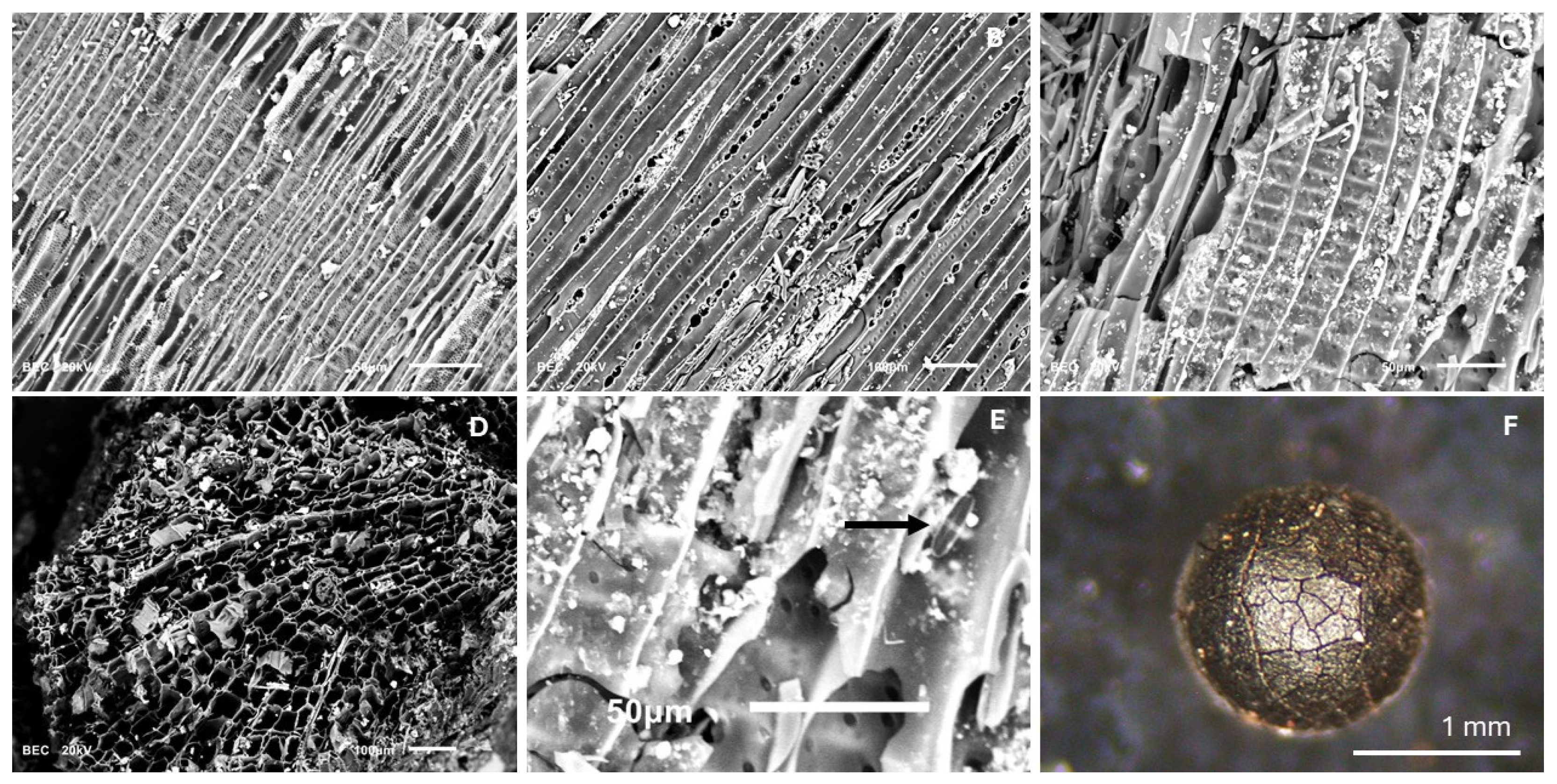
Charcoal was manually picked from eight samples processed for plant and insect remains (Figure 2, a 2020 scheme); charred material was found in four samples. Botanical identification of charred remains was performed under an incident-light petrographic microscope and a scanning electron microscope (SEM). Wood descriptions, microphotographs, and anatomy manuals [62,63,64] were consulted as references. The following features of the charcoal assemblages were recorded: number of charred particles per sample volume, signs of lateral transport, surface coating of charcoal fragments, and species composition.

3.8. Analysis of Invertebrate Macrofossils

Samples for invertebrate macrofossil analysis were collected from the lower peat, peaty clay, upper peat, and overlying clayey silt units (Figure 2D). Some insects were manually picked from peat layers in the field when visible in the outcrop. Eight 2-L sediment samples were wet sieved through a 0.4 mm mesh; invertebrate fragments larger than 2 mm were picked using a headlamp magnifier, and smaller fractions were examined under a stereoscopic microscope. Identification was aided by comparison with modern collections at the Borissiak Paleontological Institute (Moscow). Ranges and ecological preferences of insects were determined following [65,66,67,68,69,70,71].
Fragments of Chironomidae larvae were occasionally found, but as these occurrences were rare, no specific extraction methods were applied; such finds are reported without species identification.
Ecocodes were applied to describe ecological groups of insects using published data on species ecology and distribution [66,67,68] and others. An EcoCode was assigned to each insect species. The groups used were: aq—aquatic; ri—riparian; fo—forest indicators; pl—plant litter, soil, dung, carrion, and fungi; ph—phytophagous (green parts of terrestrial plants); mo—moss feeders; tu—tundra; xe—xerophilous (open or disturbed ground, dry grasslands).
Microremains of aquatic invertebrates were analyzed only in samples from clay units beneath the lower peat and above the upper peat (DQ-I) (Figure 2D). Sample processing followed the procedure of [72]. To analyze aquatic invertebrate remains, sediment samples were soaked in water and wet sieved through a 100 μm mesh under running water. The residue remaining on the sieve was transferred into a 100 mL beaker with filtered water, shaken, and the suspension of organic and fine mineral particles was transferred to a clean beaker, allowing larger mineral particles (sand and small gravel) to settle. The suspension was left to stand for 1 h, after which excess water was removed. The residue, with 2–5 mL of water, was transferred to a test tube and used to prepare microscope slides. Two to three drops of glycerol and one drop of the residual material were placed on a glass slide, thoroughly mixed, and covered with a cover slip. Analyses were carried out using bright-field microscopy at 100× and 200× magnification. All invertebrate remains were counted, with each identified subfossil fragment considered a single unit of the corresponding group. Between 150 and 350 sub-fossils were counted per sample.

4. Results

4.1. Chronology

4.1.1. 230Th/U Chronology

Fourteen subsamples were collected from the lower peat for 230Th/U: seven from a vertical profile of the lower third of the peat layer (Group 1) and an additional seven from the basal part of the same layer outside the main profile (Group 2). The specific activities of 238U, 234U, and 230Th of the two groups were considerably different (Table S1). These differences suggest that peat samples from the two groups may have formed under distinct moisture conditions. Consequently, variations in detrital contamination between the groups cannot be ruled out. Therefore, the isochron approximation for 230Th/U dating [15,16,17] was applied separately to each group (Figure S1).
The correction index f (the intercept of the linear regression on the y-axis, 230Th/232Th), which reflects the amount of detrital thorium contamination, differs between Groups 1 and 2. The best fit for linear regressions across all four coordinate systems was achieved using four samples from each group. Based on the linear calculation technique [12] and linear coefficients f and g (Figure S1), the 230Th/U isochron ages were 105 ± 4 ka for the four samples of Group 1 (Figure S1A) and 113 ± 3 ka for the four samples of Group 2 (Figure S1B).
The age discrepancy between the two groups can be attributed to several factors. Samples in Group 1 are slightly younger (Figure 2), and using only four samples per group increases statistical uncertainty. Additionally, minor deviations from the assumptions of a closed radiometric system cannot be entirely excluded. Nevertheless, the overall agreement of the ages suggests that any such influence was negligible. Based on these results, the estimated age range for the onset of lower peat accumulation is 105–113 ka.

4.1.2. OSL Dating

Five OSL dates were obtained (Figure 2, a 2020 scheme; Figure 3C–E). The brown fluvioglacial sand, 3 m below the lower peat, yielded an OSL age of 259 ± 27 ka, while grey silt 0.2 m below the contact with the lower peat was dated to 91 ± 6 ka (Figure 2). The 230Th/U age for the lower peat was slightly older at 106 ± 4 ka; however, the difference is not significant, and both methods yield broadly consistent results of approximately 100 ka. A sand lens beneath the lower peat sublayer within the peaty clay unit yielded an OSL age of 70 ± 6 ka, and the clayey silt infill of a cryogenic wedge was dated to 53 ± 4 ka.

4.2. Pollen

The pollen diagram (Figure 4 and Figure S2) incorporates results from both 2020 and 2021 sampling, supported by the OSL and 230Th/U chronology. The diagram covers vegetation dynamics over approximately 50 millennia. Based on pollen composition and cluster analysis, the diagram can be divided into 11 local pollen zones (LPZs):
LPZ 1 (sand unit, silty sand layer; OSL date from the base 259 ± 27 ka)—Arboreal pollen (AP) accounts for 85%, dominated by Betula (9%) with minor contributions from Pinus, Picea, Abies, Larix, Juniperus, and single grains of broad-leaved taxa. Pollen concentration is low, and reworked spores from Carboniferous bedrock are abundant (up to 30%). This zone reflects mixed forests dominated by birch.
A sedimentary hiatus occurs between zones 1 and 2; these sediments contain no pollen.
LPZ 2 (grey silt with bluish-gray clay sublayers)—AP comprises 30–50%, represented by Picea and Betula (up to 30%). Non-arboreal pollen (NAP) is dominated by Artemisia (40%) and Amaranthaceae (10–15%). This zone reflects open, steppe-dominated landscapes with small birch and spruce forest pockets.
LPZ 3 (lower peat; OSL date of sand lens beneath 91 ± 6 ka; 230Th/U base age 106–113 ± 4 ka)—AP reaches 99%, dominated by Corylus (45%) and Alnus (15%); Carpinus, Quercus, Tilia, and Ulmus each contribute 5–10%. Conifers are absent. Sphagnum comprises 10% of the total pollen and spores. This subzone reflects the maximum extent of broad-leaved forests.
LPZ 4 (peaty clay unit, silt layer)—AP declines to 70%, with tree proportions reduced to 10–20% for broad-leaved taxa and 12% for Corylus. Pinus and tundra shrubs (Salix, Duschekia fruticosa, Betula nana, Ericales) appear. Herbaceous taxa diversity increases, dominated by Artemisia (15–20%) and Poaceae (8%), with meadow/tundra taxa including Amaranthaceae, Caryophyllaceae, Polygonum, Ranunculus, Asteraceae, Fabaceae, Apiaceae, Rosaceae, Rumex, and Filipendula. Sphagnum mosses are 6–8%, with sporadic lycopods and ferns. Microcharcoal is abundant at the upper boundary. This zone reflects a semi-open landscape of mixed forests, broad-leaved groves, and open steppe communities, with an abrupt climatic shift toward aridity indicated by a decline in AP to 42%, disappearance of Pinus, Alnus, and broad-leaved taxa, and an increase in Artemisia (35%), Filipendula (8%), and tundra elements (Dryas, Geranium, Scabiosa).
LPZ 5 (peaty clay, black clay/gyttja)—AP increases to 80–90%, dominated by Betula, with Corylus up to 10%. Other tree taxa are <1%, tundra shrubs are absent. NAP is 10–20%, mainly Artemisia (5%) and Poaceae (5–10%), with minor contributions from Armeria, Apiaceae, Asteraceae, Amaranthaceae, Caryophyllaceae, and Filipendula. Aquatic and wetland taxa reappear (Cyperaceae, Comarum, Alisma, Sparganium, Osmunda). This zone reflects reestablishment of birch-dominated forest or birch forest–tundra with resumption of waterlogged conditions.
LPZ 6 (peaty clay, black peaty clay/gyttja)—AP remains 80–90%, with Betula dominant and Pinus increasing to 60%, Picea up to 6%, and solitary pollen of broad-leaved trees (Quercus, Tilia, Ulmus, Carpinus). NAP 10–20% includes Artemisia (6–8%), Poaceae (up to 10%), Cyperaceae, Asteraceae, Liliaceae, Amaranthaceae, Apiaceae, Caryophyllaceae, Scabiosa, Ranunculus, Polygonum, Thalictrum, and Onagraceae. Aquatic pollen nearly absent; spores < 5%. The landscape is predominantly forested, dominated by pine and birch with some spruce and scattered broad-leaved trees.
LPZ 7 (peaty clay—transitional brownish-black clay beneath upper peat)—AP de-clines to 60%, mainly due to sharp reductions in Pinus (<10%) and Picea (<2%), while Betula remains dominant (50%). Broad-leaved pollen occurs sporadically. NAP rises to 30%, primarily Artemisia (20%). Aquatic taxa reappear (Myriophyllum, Alisma, Comarum, Sparganium, Sagittaria), and Sphagnum spores return (up to 10%). This zone reflects a decline in coniferous forests and formation of an open tundra-steppe landscape with sparse birch woodlands.
LPZ 8 (upper peat, lower part, hypnic moss peat)—AP declines to ≤40%, with Betula (20–35%) as the only dominant tree taxon. Other woody taxa (Pinus, Picea) appear sporadically. Shrubs and dwarf shrubs increase (Betula nana 10–15%, Frangula, Salix, Duschekia fruticosa, Juniperus). NAP rises to 60%, with Artemisia up to 20% and Poaceae 20%. Herbaceous diversity expands (Cyperaceae, Asteraceae, Liliaceae, Boraginaceae, Saxifraga, Fabaceae, Rubiaceae, Polygonum, Polemonium, Amaranthaceae, Apiaceae, Caryophyllaceae, Scabiosa, Ranunculus, Thalictrum, Onagraceae). Wetland taxa peak at 6% (Sparganium, Myriophyllum, Alisma, Comarum, Typha latifolia). This zone reflects tundra and tundra-steppe vegetation under cooler, relatively humid conditions with a shallow waterbody.
LPZ 9 (upper peat, mid-part, folic-sphagnum peat)—AP rises sharply to 80–85%, mainly due to Picea (20–50%) and Betula (40–50%). Other trees, including Abies, Larix, Pi-nus sibirica-type, and broad-leaved taxa, are isolated. Betula nana disappears, ericaceous shrubs reach 15%. NAP decreases to 10–15%, Poaceae < 5%, Artemisia 5–10%. Wetland taxa (Alisma, Sparganium, Typha) remain but decline. The zone reflects closed-canopy spruce forest formation.
LPZ 10 (upper peat, upper part, folic-sphagnum-hypnic moss peat)—Similar to LPZ 9, but Pinus reappears, ericaceous shrubs increase to 10%, and Sphagnum spores reach 60%. Microscopic charcoal is present throughout. The assemblage reflects a Sphagnum bog surrounded by spruce-dominated forests under relatively warm, humid conditions.
LPZ 11 (clayey silt above upper peat)—AP declines to ~50%, with Betula as the only consistently present tree. Other trees nearly disappear. Ericaceous shrubs decline; Betula nana (up to 10%), Salix (~2%), and Rubus chamaemorus reappear. NAP increases sharply, with Poaceae up to 30%, Liliaceae 25%, and Artemisia 15%, along with Saxifraga, Ranun-culus, Filipendula, Dryas, Polemonium, Polygonum, Sanguisorba, Scabiosa, Thalictrum, Asteraceae, Apiaceae, Caryophyllaceae, Amaranthaceae, Fabaceae, Lamiaceae, and Onagraceae. Sphagnum spores decline to ~5%, Osmunda reaches a similar proportion, and lycopod spores appear sporadically. This zone reflects an open grass- and shrub-tundra landscape under cooler, drier conditions, likely following a hydrological disturbance indicated by the geological unconformity and abrupt changes in Sphagnum spores. The upper boundary yielded an OSL date of 54 ± 4 ka.

4.3. Pollen-Based Biome Reconstruction

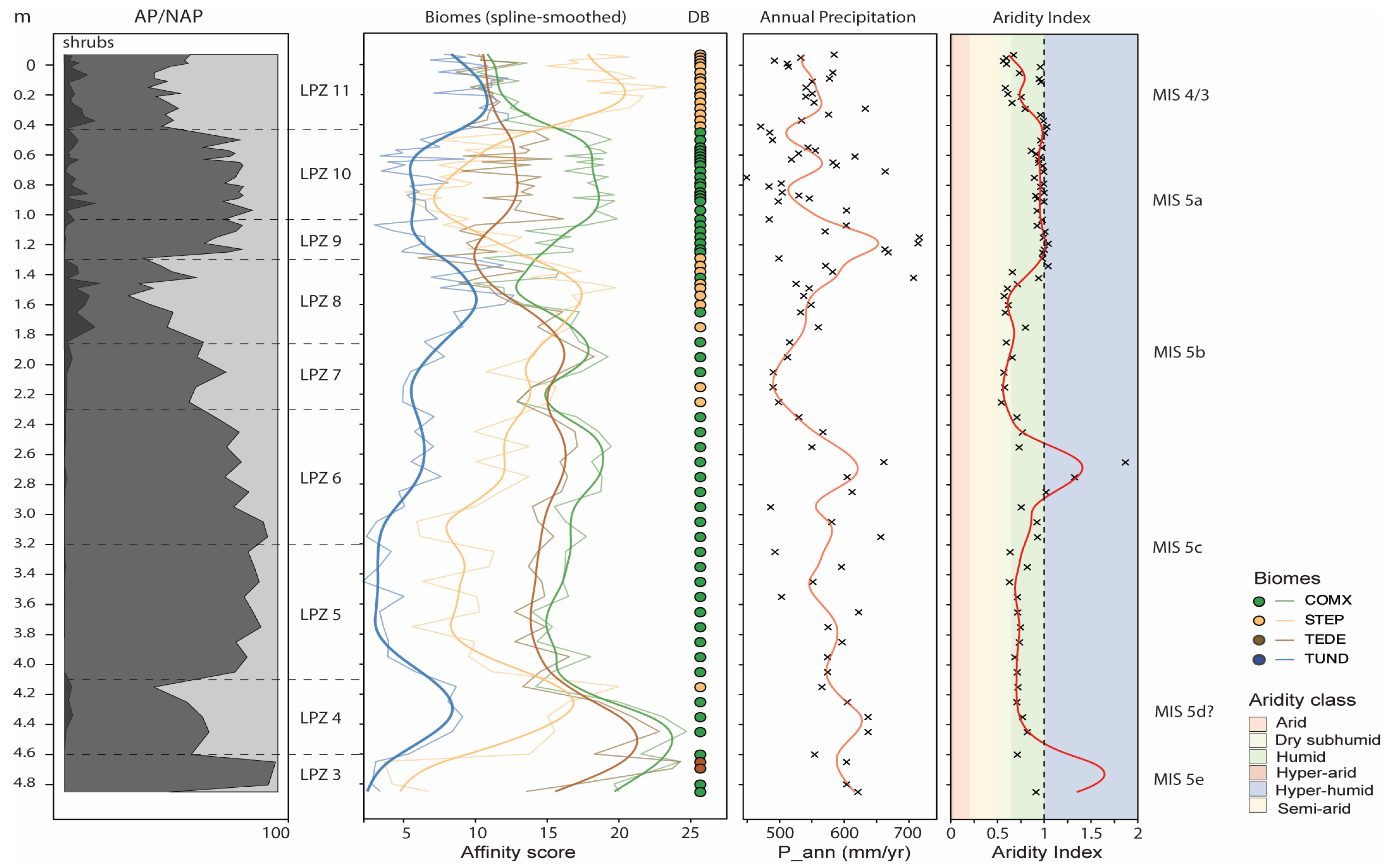
Figure 5 presents the curves of affinity scores for the four main biomes reconstructed from the pollen data. The dominant biomes are mixed temperate forests (COMX) and cold steppes (STEPPE), which exhibit inverse fluctuations over time. The temperate deciduous forest biome (TEDE) is reconstructed only for two samples from the lower peat, dated by 230Th/U 106 ± 4 ka and 113 ± 4 ka (Mikulino interglacial sensu lato). (Mikulino interglacial sensu lato). Affinity scores for tundra (TUND) are never dominant; however, the TUND curve varies synchronously with STEPPE, supporting the interpretation of the reconstructed STEP biome as representing cold steppes or steppe-tundra.

4.4. Pollen-Based Climate Reconstruction

Figure 5 presents the reconstructed values of mean annual precipitation (P_ann) and the aridity index (AI).
Reconstructed annual precipitation fluctuates between 550- and 650-mm yr−1. The precipitation curve shows a gradual decline over time, punctuated by two notable deviations: a sharp decrease between LPZ 6 and LPZ 7, followed by a pronounced increase in LPZ 9. Short-term fluctuations of approximately 50 mm yr−1 are observed within the broader trend. The aridity index (Figure 5) indicates hyper-humid conditions during the accumulation of the lower peat. During the formation of the peaty clay unit (LPZ 4, 5, and 7), conditions fluctuated near the boundary between humid and dry subhumid, except for a hyper-humid episode during LPZ 6. Climatic conditions during the upper peat (LPZ 9 and 10) were marginal between hyper-humid and humid, while dry subhumid conditions were reached only in the clayey silt unit (LPZ 11).
Aridity closely covaries with the proportion of shrubs and grasses and shows a negative correlation with the proportion of arboreal pollen.

4.5. Plant Macrofossils

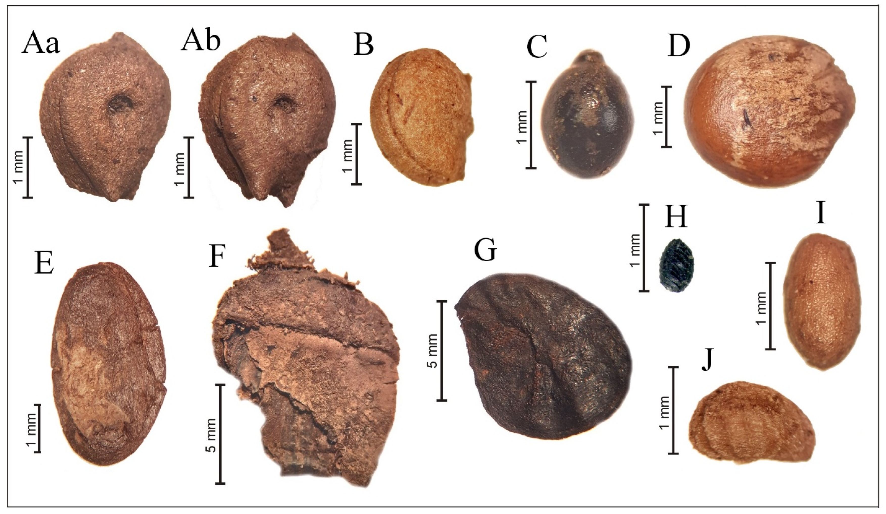
Plant macrofossils were analyzed in samples from the peat units and the deposits separating them (Figure 6, Table S2). The number of recovered macrofossils varied from 10 to 146 per sample, with the highest counts in the lower peat (104) and in the peaty clay unit (146 in the bottom and 92 in the upper part of the unit, respectively).
The lower peat unit consists primarily of stems of sedges, horsetails, and mosses (Sphagnum and green mosses). Taxa recovered include the bog dwarf shrub leatherleaf (Chamaedaphne calyculata), tree birch (Betula sect. Betula), hazel (Corylus avellana), pine (Pinus sylvestris), oak (Quercus robur, Figure 6F), and maple (Acer sp., Figure 6G). Seeds of the carnivorous plant waterwheel (Aldrovanda vesiculosa, Droseraceae) were abundant (Figure 6C). In Europe, this endangered species survives in isolated localities and reproduces mainly vegetatively [73]. Subfossil seeds of Aldrovanda are known from many Middle and Late Pleistocene sites in Eastern and Central Europe, and are characteristic of interglacial units, particularly the Mikulino [74]. Although rare finds occur in Holocene deposits, mild interglacial conditions were most favorable for seed reproduction during the Pleistocene [74,75,76]. In the Ivantzevo section, the co-occurrence of Aldrovanda seeds with broad-leaved tree remains indicates interglacial climatic conditions during lower peat accumulation.
Samples from the silt layer above the lower peat yielded numerous fruits of Carex sp. and Eleocharis palustris, but their stems were absent, likely due to transport into the central pond area or taphonomic conditions unfavorable for preservation. Other aquatic plants recovered include Myriophyllum verticillatum (fruits) and Potamogeton gramineus (endocarps).
Macroremains from the basal part of the upper peat unit include aquatic taxa such as Najas flexilis (seeds), P. gramineus (endocarps), and megaspores of the aquatic lycophyte Isoetes lacustris. Terrestrial plants are represented by nutlets of shrub birch (Betula cf. nana) and tree birch (Betula sect. Alba). The presence of shrub birch suggests a phase of climatic cooling.
Samples from the top part of the upper peat unit contained seeds of thermophilous aquatic plants, including Nuphar lutea and Ceratophyllum demersum. A few endocarps of the extinct pondweed Potamogeton sukaczevii were also identified; this species has previously been described from several Eastern European and British localities, in deposits of the Last Interglacial (MIS 5e) and the first interstadial of the subsequent glacial epoch (Brörup or Upper Volga Interstadial, presumably MIS 5c) [73,75,76]. Other pondweed species present include P. filiformis, P. rutilus, and P. natans endocarps. Numerous fruits of Ranunculus aquatilis were also recovered.
Sample Dm-B6, from the silt layer covering the upper peat, contained over 100 seeds of Ranunculus aquatilis, along with solitary seeds of Myriophyllum verticillatum, Chamaedaphne calyculata, and Potentilla sp. The high abundance of Ranunculus aquatilis may indicate a temporary increase in water level during this period.

4.6. Charred Plant Remains

Macro-charcoal was recovered from four samples: two from the peaty clay unit (DM-B1 and DM-B3) and two from the upper peat (DM-B2 and DM-B2a) (Figure 7, Table S3). Microscopic charcoal was also present in two of these layers. In particular, MIS 5d shows abundant charcoal at the upper boundary of LPZ 4, while MIS 5a contains charcoal consistently in smaller quantities across LPZ 10, with a peak concentration at the top of the layer.
Samples DM-B1 (LPZ 4) and DM-B3 (LPZ 5–6) contained only solitary charred Cenococcum sp. sclerotia, part of conifers’ ectomycorrhizal fungi, with one and two sclerotia per 2 L sample, respectively. Unexpectedly, a soot- and mud-coated oogonium of Chara was observed in DM-B3 (LPZ 5–6).
Sample DM-B2 (LPZ 9–10) contained six charred wood fragments representing four taxa: Pinus, Juniperus, Picea, and Ericaceae. Maximum fragment dimensions were 6 mm in length and 4 mm in width. Pine charcoal fragments were mud-coated and slightly rounded, with a length-to-width ratio of 0.6, suggesting short-distance lateral transport, possibly from the pond margin. In addition, this sample contained approximately 60 Cenococcum sclerotia, 1–1.5 mm in diameter.
Sample DM-B2a (LPZ 9–10) contained only 3 charcoal fragments—2 fragments of Picea stem wood, and 1 fragment of Pinaceae root wood, along with ca. 80 mud-coated Cenococcum sp. sclerotia. The charcoal fragments are slightly vitrified, with soot deposited on some surfaces. Diatoms were observed atop the charcoal fragments (Figure 7E), likely reflecting water-level fluctuations: charcoal was deposited after a fire during low water levels and subsequently submerged. Notably, no iron oxide deposition was observed on these charcoal fragments.
The occurrence of charred roots, ectomycorrhizal sclerotia (Cenococcum sp.), and ericaceous dwarf shrubs in the upper peat indicates peat fires. The presence of soot atop charcoal suggests that the folic hypnic moss peat (the upper peat layer) experienced multiple fire events.

4.7. Macrofossils of Invertebrates

The concentration of invertebrate remains varied among sedimentary units (Figure 7, Table S4), from relatively numerous faunal remains in peat and gyttja to solitary finds in clay and silt. The maximum number of remains was found in the lower peat unit.
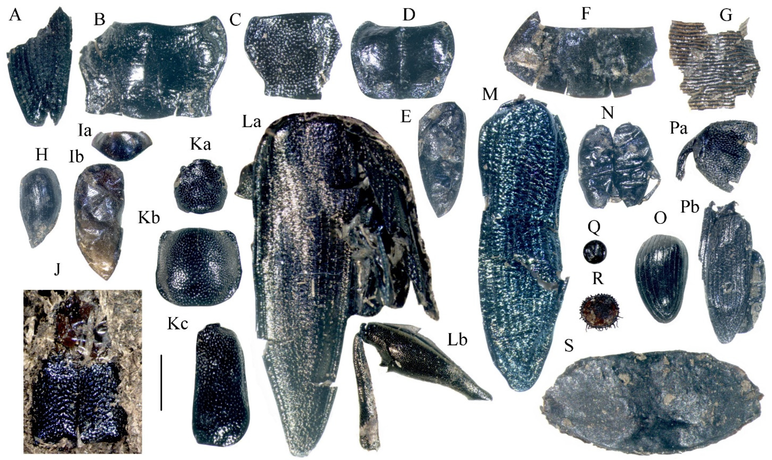
We applied two collection techniques for this unit. One sample (Dm-B5a) contains invertebrates (mainly insects) collected manually from a large area of peat on the section wall. This technique allows sampling of well-preserved specimens suitable for museum collections, but leads to misrepresentation of species, featuring mainly large leaf beetles (Plateumaris braccata), several large diving and ground beetles, and only single small-sized insects, such as pill- and rove beetles.
The leaf beetle P. braccata occurs on reed and sedges; the larvae feed on roots of common reed Phragmites australis. Abundance of P. braccata corresponds with the botanical composition of the encasing peat sub-layer (compressed stems of reeds and sedges).
Another sample (Dm-B5) was collected as a peat monolith 20 × 30 × 10 cm. Here, large invertebrate remains were picked manually, and the rest of the sample was wet sieved. The remains are more diverse in this sample and include aquatic, riparian, and terrestrial insects and other invertebrates. Water inhabitants are represented by several genera of diving beetles (Dytiscidae: Agabus, Colymbetes, Dytiscus, Hydroporus [including H. morio]); these beetles are typical for the modern entomofauna of small ponds in northern Europe and Siberia. Modern aquatic fauna of the Moscow Region is different and more diverse, with diving beetles of the genera Hygrotus, Rhantus, and Acilius being common. The aquatic group also includes several species of weevils and leaf beetles; some of them are found in Dm-B5. Many small fragments and a few whole bodies (Figure 8) belong to the bladderwort flea-beetle Longitarsus nigerrimus, which occurs on Utricularia sp. under water. One fragment belongs to a weevil Bagous sp. (most likely Bagous limosus), which feeds on pondweeds (Potamogeton spp.).
The pond bank environment is a habitat for numerous phytophagous insects. In addition to the remains of Plateumaris braccata, which are extremely abundant in some loci within the peat layer, the sample yielded the leaf beetle Donacia dentata (host plant is arrowhead, Sagittaria sagittifolia) and cocoons, probably from pupae of Donaciini leaf beetles (Plateumaris and Donacia). The weevil Limnobaris dolorosa lives on various semi-aquatic grasses (Carex, Scirpus, and Juncus). The ground beetle Stenolophus mixtus occurs in various wetlands and can be considerably abundant in reed beds [51].
The peat samples also yielded large grey silky cocoons of a raft spider Dolomedes sp. (Figure 9). The spider hunts aquatic insects and small fish while sitting on a floating stem or piece of wood, with some of its legs on the water.
All listed insects and the spider indicate the presence of a waterbody with shallow edges covered by grassy sedge and reed vegetation.
Some insects recorded in Dm-B5 live in various wetlands, woodlands, and meadows, but their larvae develop in water and prefer small ponds. These include ground beetles Bembidion spp., Trechus secalis, Agonum sp., and Chlaenius sp. Many recovered fragments belong to the marsh beetle Scirtes hemisphaericus.
The assemblage includes several forest indicators: the ground beetles Pterostichus strenuus, P. oblongopunctatus (prefers broadleaf and mixed woodland), P. nigrita, Calathus sp., and two species of ants. Ground beetles Ophonus puncticeps, Anisodactylus sp. occur in open grounds and dry meadows.
A large part of the assemblage belongs to the insect group associated with plant litter. Some of these insects prefer moist soil and live near water, such as the water scavenger beetle Cercyon impressus and the rove beetles Olophrum rotundicolle, Quedius spp. The rove beetle Paederus littoralis commonly inhabits wetlands but can be found on dry open ground.
The assemblage includes two species of moss feeders (pill beetles Cytilus sericeus and Byrrhus arietinus), which can live far from water in meadows and disturbed grounds with a short moss cover. Among terrestrial beetles, of interest is the leaf beetle Lema cyanella, which feeds on thistles and occurs in various habitats, including wetlands, if its host plant is present. Several species of weevils were found, including the willow feeder Dorytomus sp., associated with near-water willow shrubs. The most abundant remains are fragments of butterfly pupae (not identifiable). The insect assemblage allows reconstruction of a wetland with open water—a pond rimmed by diverse vegetation, with forest nearby.
Samples Dm-B1 and Dm-B3 come from a peaty clay unit above the lower peat. The assemblage Dm-B1, sampled immediately above the lower peat, contains remains of both aquatic and terrestrial inhabitants. We found typical forest insects, such as the ground beetle Pterostichus vernalis, the carpenter ant Camponotus herculeanus, and an earthworm cocoon (Lumbricidae), along with aquatic taxa—larvae of Chironomidae midges and water beetles.
The next sample up from the same peaty clay unit, Dm-B3, yielded a riparian ground beetle Bembidion petrosum, fragments of terrestrial ground beetles (Pterostichus sp.), and legs of large Carabidae (probably also Pterostichus), along with taxa from the plant litter group: a rove beetle Philonthus sp., dung beetle Aphodius sp., and weevils Gymnetron sp. that feed on speedwell (Veronica spp.). The same sample yielded a true aquatic animal, the freshwater bryozoan Cristatella mucedo.
The combination of aquatic and terrestrial taxa and lack of riparian insects may suggest that a pond edge was poorly vegetated during this period, and insect remains were transported from the pond banks into the water without being trapped by near-water plant barriers.
The sample Dm-B4, from the bottom part of the upper peat unit, contains a few fragments of aquatic beetles (Agabus sp. and Hydrobius fuscipes), a riparian ground beetle (Agonum sp.), a leaf beetle (Donacia sp.), a carrion beetle (Thanatophilus sp.), a small weevil of the Apioninae subfamily (usually inhabiting meadows), and an earthworm cocoon (Lumbricidae).
Samples Dm-B2 and Dm-B2a come from the top part of the upper peat unit. The aquatic group is well represented here: a whirligig beetle Gyrinus sp., diving beetles Agabus sp. and Colymbetes sp. Hydroporus sp., the leaf beetle Longitarsus nigerrimus, caddis-fly larvae (Limnephilidae), Chironomidae larvae, cocoons of leeches (Erpobdella cf. octoculata and Haemopis sanguisuga), and statoblasts of the freshwater bryozoan Cristatella mucedo.
The open ground at the pond edge was occupied by ground beetles (Bembidion [Notaphus] obliquum, Pelophila borealis, Trechus apicalis, Agonum quinquepunctatum, Sericoda quadripunc-tata, Patrobus septentrionis), the marsh beetle Scirtes hemisphaericus, and leaf beetles Donacia sp. The weevil Limnobaris dolorosa indicates riparian vegetation. The ground beetle Agonum ericeti occurs in sphagnum bogs.
Plant litter group is represented by the rove beetle Olophrum rotundicolle, Arpedium quadrum, Ochthephilum fracticorne, Quedius spp., a dung beetle Aphodius sp., and earthworm cocoons (Lumbricidae).
Terrestrial insects include a moss feeder (Byrrhus sp.), the weevil Orobitis cyaneus which feed on Viola spp., and a weevil Gymnetron sp.
Notably, remains of three ground beetles (Pelophila borealis, Diacheila polita, and Patro-bus septentrionis) clearly indicate a colder climate than present, corresponding to either tundra or forest–tundra environments. The latter is more probable, as a forest weevil (Cossonus sp.) and the carpenter ant (Camponotus herculeanus) were also found in the same deposit.
The entomofauna from the top part of the upper peat unit reflects a colder climate than modern. The pond had open water, rimmed mainly by the barren, devegetated ground, with sedges and sphagnum mosses growing at some loci. The findings suggest that the encasing landscape was covered by the boreal forest or forest–tundra.
The uppermost sample, Dm-B6, collected from the clayey silt infill of a cryogenic wedge (Figure 2 column 3, Figure 3C), was very poor in macrofossils, except for two specimens: a Planaria sp. egg and a mandible of a larval aquatic beetle (Hydrobius fuscipes, Hydrophilidae). These finds confirm the aquatic origin of the silt deposit.

4.8. Planktonic Crustaceans and Other Aquatic Microfauna

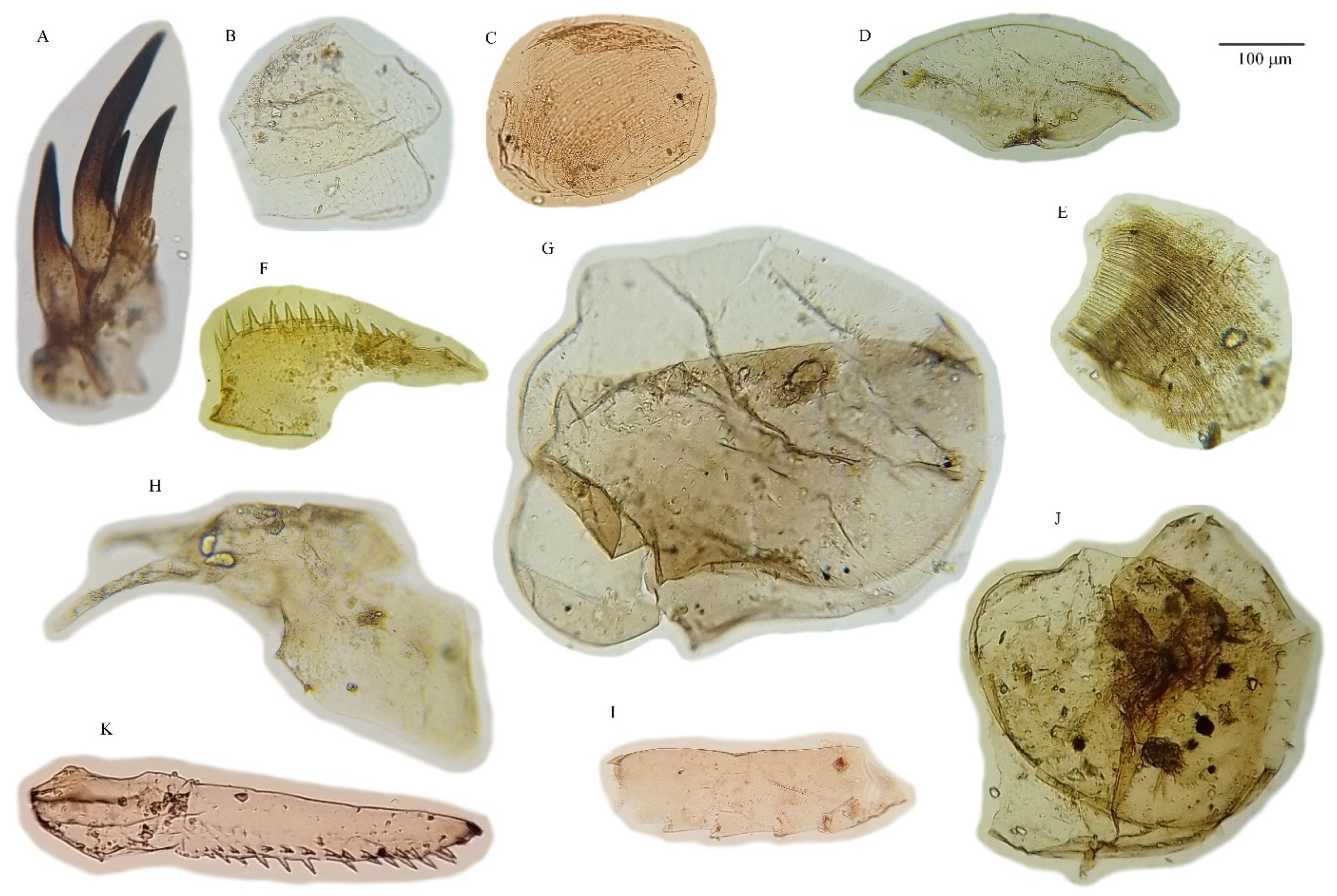
In accordance with the methods for the extraction of planktonic crustaceans, the crustaceans were recovered only from lacustrine deposits—the grey silt/grey clay unit beneath the lower peat and the clayey silt units above the upper peat. Fourteen samples from the grey silt/grey clay unit and eight samples from the clayey silt unit were analyzed. The micro-remains belong to several groups of invertebrates (Figure 10):
1. Freshwater sponges. The sediment yielded sponge spicules of Spongilla sp. and, probably, Ephydatia sp.; the spicules were found at a depth of 80 cm from the top of the grey silt unit, but the maximum concentration was observed at the contact of the grey silt with the lower peat. In the upper clayey silt unit, the spicules appeared near the top of the unit. The increase in spicule concentration indicates shallowing of the waterbody and occupation of the pond’s bottom by aquatic plants.
2. Micro-remains of insects. Fragments of Chironomidae larvae were found in almost all samples; the maximum (up to 10–23% of all fragments) was in the DQ-II samples (Figure 2D), in the grey silt unit at depths of 140 to 80 cm below its contact with the lower peat. Larvae of another group of aquatic Diptera—Chaoboridae (Chaoborus sp., Figure 10)—were found at depths of 70 to 0 cm below the lower peat. The Chaoboridae inhabit forested -regions. Other insects include Trichoptera, Plecoptera, and Ephemeroptera; their abundance increased at depths from 50 to 0 cm below the lower peat.
3. Cladocera. This group dominates the assemblages, with at least 29 species recorded. The most common species are Eubosmina (Bosmina) longispina, Chydorus sphaericus s.l., Acroperus harpae, and Biapertura (Alona) affinis., E. longispina is a pelagic species; its appearance corresponds with a high-water level. At the same time, the samples yielded Bosmina longirostris, which occurs in shallow water.

5. Discussion

5.1. Chronological Correlation of Peat Units with Mikulino Interglaciation

Quaternary stratigraphy is mainly based on tracing climate oscillations. Interglaciations are reconstructed based on comparison with the type sites/reference sections using various approaches, but mainly paleobotanical data. The Last Interglacial (LI) unit in the Quaternary chronology got its name after the river Eem in Netherlands where the interglacial deposit has been described; another LI type site is located near the village of Mikulino in the Smolensk Region of Russia.
The Eemian stratum is well studied in Europe, and its age is established and correlated with marine isotope stages [1,2,77,78,79]. There are two definitions of the LI [52]: sensu lato LI equivalent to MIS5 (130–80 ka yr), and sensu stricto LI or Eemian to part of MIS5e-d (127–107 ka). Climate cooling that preceded the Last Glaciation (LG, Weichselian in Europe and Valdai in Russia) s. str. starts ca. 107 ka ago. The European scientific community generally accepted the s. str definition of LI and LG [3,7,80,81,82,83] and others.
The Mikulino type site is a key reference point for correlating the Late Pleistocene interglacial periods of Europe and Russia. Based on pollen data from the Mikulino section in the Smolensk region, a stratigraphic framework was developed that divides the Mikulino Interglacial into stages M2–M8 [84]. Stages M4–M6 correspond to the thermal optimum, characterized by the dominance of broad-leaved tree pollen, with a peak of Corylus at the M4/M5 boundary [84]. These stages can be confidently correlated with the European Eemian stage E4. The final stages, M7–M8, are usually correlated with Eemian stages E6–E7 (MIS5d) [84,85,86], although there are alternative interpretations that associate them with later interstadials, such as MIS5c or MIS5a [87].
A number of publications describe the “Mikulino peat” in the Central Russia, several of them documenting it in the vicinity of the Ivantzevo site [30,32,33,34,35], and comparing fossil peat pollen spectra with the pollen spectra of the type site as the means to validate the LI age of the local peat units.
The Mikulino section bears a certain similarity to the Ivantzevo site. The section is underlain by a sandy moraine, the LI strata beginning with the gyttja, superposed by a 2–3 m thick peat unit, and the peat is topped with the new unit of gyttja, sand and silt. The pollen diagram of the Mikulino section features subsequent peaks in Quercus, Ulmus и Corylus pollen in the lower gyttja (underlying the LI peat unit) and a clear peak in the pollen of Tilia and Carpinus in the peat unit. The transition from the LI to the Early Glacial is marked by successions in the dominant arboreal taxa in the pollen spectra, Quercus-Ulmus-Corylus-Tilia-Carpinus-Picea.
The development of geochronological frameworks for the Mikulino site and other classic interglacial sections in Central Russia began relatively recently, with the application of OSL and 230Th/U dating techniques [11,14,15,16,17,43,87]. Maksimov et al. [16,17] correlated all available 230Th/U and pollen data from Mikulino and key sections in the Tver, Smolensk, Moscow, and Yaroslavl regions, as well as Belarus, establishing approximate chronological boundaries for the Mikulino Interglacial and its phases. According to the results, the beginning of the Mikulino Interglacial dates to approximately 130–126 ka. The first phase (M2) ended around 118 ka, while the pre-optimal vegetation stages (M3–M4) span roughly 118–112 ka. The climatic optimum (M5–M6), marked by the dominance of Corylus, began around 112 ka and ended by approximately 100 ka ago. These estimates are supported by 230Th/U dates for the initial and middle phases of the Eemian Interglacial in Germany: Banzin—118 ± 10/8 ka (L/L) and 121 ± 12/9 ka (TSD); Beckentin—118 ± 7/6 ka (L/L) and 114 ± 6/5 ka (TSD); Mühle—116 ± 13/10 ka (TSD) [44].
We can see that the 230Th/U dates from Central Russia do not fully align with the boundaries of MIS5e–d (Eemian). The 230Th/U date for the peat from the Mikulino section is 110 ± 6/5 ka, corresponding to the very end of the Eemian Interglacial (MIS 5d). Similar discrepancies are observed in other sites: while the onset and early stages of the Mikulino Interglacial, according to 230Th/U data, correspond to MIS 5e, the dates obtained for the thermal optimum often fall within MIS 5d or even MIS 5c. Thus, although the dates obtained in our study appear somewhat younger than expected, they are consistent with results from other sections in the region and do not contradict the regional chronological framework.
All five OSL dates obtained for mineral layers in the Ivantzevo section are in correct chronological order, with no inversions. The OSL date from the layer beneath the lower peat unit is slightly younger than the age estimated by the 230Th/U method (91 ± 6 ka and 106 ± 4 ka, respectively; Figure 2), but this difference falls within the error margins of the dating methods. This agreement validates the other OSL dates from the section, placing the age of the peaty clay (70 ± 6 ka) within MIS 5a and the age of the clayey silt (53 ± 4 ka) within MIS 3. Due to a likely break in sedimentation between the upper peat layer and the overlying clayey silt, indicated by cryogenic wedges, this unit was tentatively assigned to MIS 4/3. These dates were used as a chronological framework for correlating local pollen zones to specific marine isotope stages.
The difference between the OSL and 230Th/U ages can also be interpreted as a slight underestimation of deposit ages by OSL dating, by 5–14 ka. If the age of the upper silt deposit were corrected accordingly, it would be estimated at 58–67 ka, still closely corresponding to the lower boundary of MIS 3.

5.2. Regional Climate and Ecosystems Dynamics

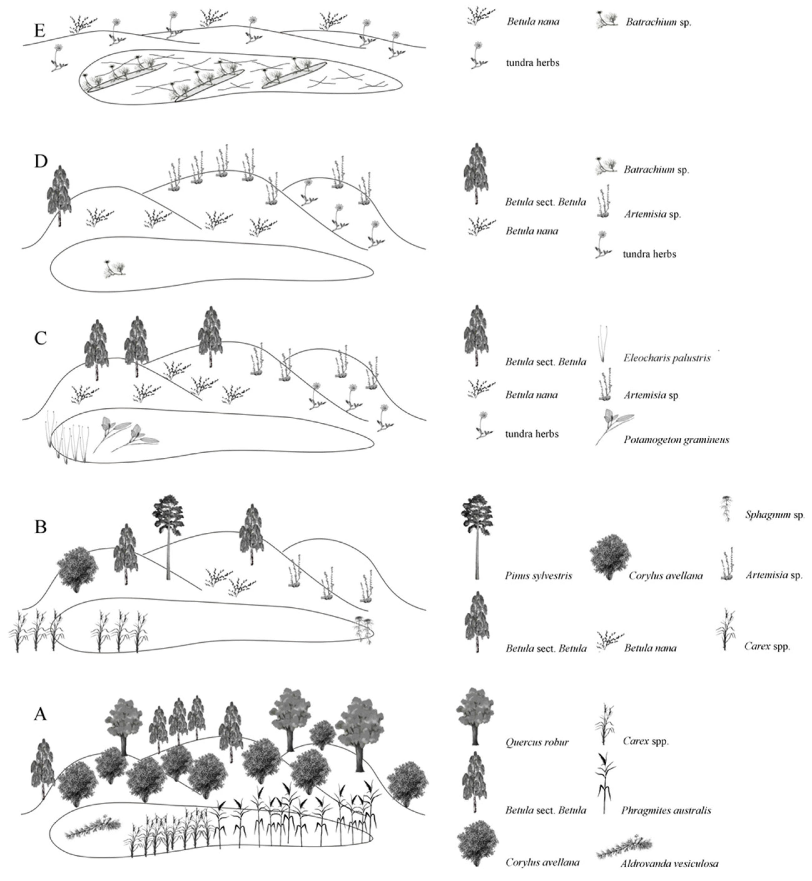
Pollen records and pollen-based biome and climate reconstructions (Figure 4 and Figure 5) allow us to identify at least eight distinct phases of vegetation change. The reconstructions based on plant and invertebrate macrofossils were of lower resolution but complement and extend the palynology-based reconstruction.
We attempted correlation of pollen phases with stages of Mikulino (Eemian) and Early Valdai (Weichselian), using published data from other reference sections of these periods in Europe and the region [1,2,3,8,9,10,14,15,16,17,32,33,34,82,83,84,85,86,87,88,89,90,91]. The results of the pollen-based correlation are presented in Table 1. While Mikulino chronology is based on numerous dates, often contradictory, dates for Valdai deposits in Russia are very sparse. Difficulties in stratigraphic correlation of interstadials within the region, due to unreliable dates and the similarity of vegetation reconstructed for non-contemporary episodes, were described by [91]. In interpreting our pollen spectra, we considered their similarity with well-dated Eemian and Weichselian sequences of Central Europe [82,83] and our OSL and 230Th/U dates.
Phase 1 (LPZ 1)—mixed forests (dominant biome COMX), reconstructed from only two samples from the lowest part of the section (grey silt/grey clay unit) with an OSL date of 259 ka at the basal level. It is characterized by dominance of tree birch and a proportion of conifers (Picea, Pinus, Abies, Larix) and broad-leaved trees (Tilia, Ulmus), with the presence of reworked pre-Quaternary spores. Such a mixture is characteristic of outwash fen deposits. The pollen spectrum may reflect the end of the previous interglacial period, supported by the OSL date. There is a time gap between phases 1 and 2, as the deposits between them do not contain pollen.
Phase 2 (LPZ 2)—cold steppes dominated by Artemisia and Amaranthaceae, with small patches of Betula and Picea (dominant biome STEP). This phase was reconstructed from only three samples from sandy loam and clay underlying the Mikulino horizon (lower peat). It presumably reflects the vegetation of the terminal stages of the Moscow Glaciation and the transition to the interglacial, corresponding to MIS 6a. The reconstructed annual precipitation for this phase is 500 mm, and Aridity Index (AI) is 0.75, parameters typical for the modern forest-steppe zone. There was a break between phases 2 and 3 due to discontinuous sampling.
Phase 3 (LPZ 3)—thermophilic broad-leaved forests with hazel undergrowth, documented in two samples from the lower peat, appear to represent the Mikulino thermal maximum, M4-5 according to Grichuk [84]. This phase corresponds to the Eemian Interglacial (MIS 5e). This interpretation is supported by the absolute dominance of Corylus and broad-leaved taxa, both in pollen and plant macrofossils, which is characteristic of stage M5 in all regional sections [14,16,17], as well as by the presence of the thermophilic aquatic carnivorous plant Aldrovanda vesiculosa. For this phase, the TEDE (Temperate deciduous forest) biome has been reconstructed, with annual precipitation of 600 mm and an AI increase to 1.7. Other phases of Mikulino (M2, M3, M5, and M6) are not represented in our pollen record, likely due to interruptions in sediment accumulation or the specifics of sample selection.
Phase 4 (LPZ 4) in its lower and central parts, represents a combination of broad-leaved groves and open grasslands. The reconstructed biome for this phase is COMX (cool mixed forest). Signs of forest decline appear at the end of this phase, coinciding with increased fire occurrence and droughts. The upper boundary of zone 4 is marked by a short stage of cold steppe, with a simultaneous drop of the aridity index to 0.70–0.75. This phase corresponds to the vegetation of the late Mikulino interglacial (M7–M8), and its end may mark the first post-Eemian (s. stricto) cooling phase, the Herning Stadial, during which much of Northern Europe became largely treeless. It corresponds to the end of MIS 5e and MIS 5d [83].
Phase 5 (LPZ 5-6)—reconstructed from pollen spectra from the peaty silt overlying the lower peat; it features forest recovery, initially of birch and later of mixed forests dominated by Pinus, Betula, and Picea. The reconstructed biome is COMX (cool mixed forest). Peaks in precipitation (up to 630 mm) and aridity index (up to 1.5) mark the end of the phase. This phase can be correlated with the first Valdai interstadial or the final phase of the Mikulino complex. It is similar to the Brørup Interstadial, which corresponds to MIS 5c, when birch and pine woodlands expanded across Northern and Central Europe [83].
Phase 6 (LPZ 7-8) reconstructed from the bottom of the upper peat. The pollen spectrum reflects gradual degradation of coniferous forests and subsequent expansion of tundra vegetation, dominated first by grasses and later by shrubs. The second half of the phase is marked by the maximum proportion of shrubs and the presence of Betula nana and Juniperus in both pollen and macrofossil assemblages. The dominant biomes are COMX and STEP, but at the end of this phase, the TUND (tundra) biome reaches its maximum value. Climate becomes drier, with P_ann 500–550 mm and AI 0.75. The phase may be correlated with the Rederstall Stadial (MIS 5b), characterized by initially grassy and later shrubby tundra over large areas of Europe [82,83].
Phase 7 (LPZ 9-10)—top of the upper peat, reflects the rapid establishment of boreal closed-canopy spruce forests. Picea, Betula, and Ericales are abundant in pollen spectra and plant macrofossils. Seeds of thermophilic water plants (Nuphar lutea and Ceratophyllum demersum) and the extinct species Potamogeton sukaczevii indicate a relatively warm and humid climate. The dominant biomes are COMX and TAIG; precipitation increases sharply to 650 mm, and AI to 1.0. This phase may represent the vegetation of the second post-Mikulino interstadial, correlating with the Odderade (MIS 5a), when boreal forests of pine, spruce, and birch were widespread in various combinations in central and northern Europe. The end of this interstadial in Europe is radiocarbon dated to ca. 60 ka [82,83].
Phase 8 (LPZ 11)—reconstructed from clayey silt above the peat, marks abrupt degradation of forest cover, near-complete disappearance of all tree taxa except Betula, and widespread fires, resulting in cold steppe and tundra landscapes. This zone shows peaks in the STEP and TUND biomes, with a noticeable proportion of shrubs. Climate reconstructions reflect decreased precipitation and increased aridity. Pollen-based reconstructions and the OSL date of 53 ± 4 ka place this phase within the Oerel Interstadial (MIS 3), radiocarbon-dated to 54–58 ka [83]. MIS 4 deposits are not detected in our section, likely due to cold and arid conditions that did not favor lacustrine or peat accumulation. Completely treeless episodes described for MIS 4 [89] are not represented in our pollen sequence.
The vegetation phases are schematically depicted in Figure 11.

5.3. Local Ecosystem Dynamics

The sequence is composed of aquatic deposits alternating with peat. The aquatic deposits formed in a lake of variable water depth, while peat accumulated during phases of lake desiccation, due either to decreased run-off or increased evapotranspiration. The lower peat and peat-like (peaty clay) units formed during warm climatic phases of the Mikulino interglacial thermal optimum (MIS 5e) and the second interstadial (MIS 5a).
The lower peat, correlated with the Mikulino LI, contains numerous woody and grassy plant remains and abundant leaf beetle remains that inhabit reed leaves (Table S1 and Table 2, Figure 7 and Figure 8), while submerged aquatic plants are absent from the pollen spectrum. These findings indicate a marshy environment. The upper peat unit formed in a poor fen with hypnic mosses and was superposed by a clayey silt deposit, similar to the grey silt deposit at the base of the lower peat unit. The pollen spectrum, together with insect and plant macro-remains, reflects significant cooling during this phase.
The encasing landscape was occupied by periglacial tundra ecosystems, such as steppe-tundra and forest–tundra dominated by dwarf birch (Figure 11B,C).
The covering clayey silt is dissected by cryogenic wedges. According to micromorphological studies [26], the silty infill of the wedges was periodically frozen, indicating permafrost and periglacial conditions in the area during this phase. Wedge-shaped structures commonly formed in Russian Plain deposits during the Valday interval, penetrating deeply into older depositional units. Based on their presence, the top unit of the Dmitrov section can be correlated with the Selikhodvorsky cryogenic horizon (S.A. Sycheva [18,19]). The OSL date of 53 ± 4 ka for the upper unit is consistent with the final, relatively cold and dry stadial of early Valday time (MIS 4/3).
Cryogenic wedges were found in the upper part of the section, and traces of melted ice veins were inferred from the fine-grained texture of two upper gyttja layers. Morphological features of the wedges [37] suggest they formed subaerially as frozen cracks, rather than as ice wedge casts, as previously considered [26]. Nevertheless, pollen and macro-remains of aquatic plants, spicules of algae, and aquatic invertebrates, including cladocerans and Planaria eggs, were found in the wedge infill, indicating an aquatic depositional environment. These observations suggest that the pond dried out, its surface was dissected by frozen cracks, and the cracks were subsequently submerged. Instead of a single lake, a system of deep, elongated ponds appeared in the periglacial landscape. These ponds were inhabited by freshwater invertebrates, and their bottoms were covered by dense mats of water buttercup (Batrachium sp.), though insects were not preserved in the pond sediments for unknown reasons.
Plant and invertebrate macrofossils were recovered only from peat layers, the peaty clay between them, and clayey silt. Samples were collected at larger intervals than for pollen analysis, so the macrofossil data cannot achieve the same resolution. However, they better reflect local ecosystem dynamics, largely associated with hydrological changes. Chronological attribution of macrofossil assemblages is based mainly on pollen-based correlations and obtained dates (Table 2).
Plant macrofossils of aquatic plants were found in samples from all layers, indicating the persistence of a waterbody at the site. Thirteen aquatic plant taxa were documented: Chara, Ceratophyllum demersum, Eleocharis, Hippuris vulgaris, Isoetes, Menyanthes, Myriophyllum verticillatum, Najas flexilis, Nuphar lutea, Potamogeton spp., Scheuchzeria, and Batrachium sp. Notably, Aldrovanda vesiculosa was found in the lower peat, and the extinct Potamogeton sukaczevii in the upper peat. A. vesiculosa inhabits regions north and west of the study area, though its range is disjunct [74], and it disappeared from the mixed forests of European Russia. Seeds of A. vesiculosa occur in deposits dated to the Mikulino Interglacial and analogous stratigraphic units in Eastern and Central Europe and are typical for MIS 5 [75]. Aquatic taxa diversity varied from 4 taxa in lower peat (MIS 5e) to 2 taxa in peaty clay, reaching a maximum of 12 and 11 taxa, respectively, in the upper peat.
Peatbog-associated taxa included ericaceous shrubs (Chamaedaphne calyculata, Vaccin-ium oxycoccos, Vaccinium sp., Rubus sp.) and herbs (Rorippa palustris, Ranunculus sceleratus, Comarum palustre), most abundant and diverse in the upper peat (6 and 4 taxa, respectively). All other layers contained macrofossils of only 1–2 bog taxa. Botanical analysis indicates that the upper peat was dominated by Sphagnum moss, evidencing a sphagnum bog during the climatic cooling and reduced evapotranspiration.
Macrofossils of trees and tall shrubs were found only in the lower peat and the top part of the upper peat. Remains of Quercus, Acer, Picea, Corylus, and Sambucus in the lower peat (MIS 5e), including acorn cupules, indicate that oaks grew at the site. Remains of Picea, Pinus, and Betula sect. Betula were documented in the top of the upper peat. Seeds of Betula sect. Betula and Sambucus were also found in the lower part of the upper peat, though contamination from overlying peat cannot be excluded. These findings align with pollen data, confirming the presence of broad-leaved forests around the lake during MIS 5e and mixed pine-spruce-birch forests during MIS 5a.
Finally, macrofossils of Chenopodium album appeared in the upper peat, marking a transition to cold treeless grassland. Interestingly, the cumulative number of plant taxa was highest in the upper peat (24 and 19 taxa, respectively), compared to 12 taxa in the lower peat (MIS 5e) and only 4 taxa in other layers.
Charred plant macrofossils were found in four samples from three layers, correlated with MIS 5d, MIS 5c, and MIS 5a. In MIS 5d and MIS 5c layers, only solitary Cenococcum sclerotia (conifer ectomycorrhiza) were found, possibly redeposited from the lake bank due to buoyancy. In MIS 5a layers, Cenococcum sclerotia occurred in considerable quantities (60–80 per 2 L sample). Vitrified and soot-coated charcoal of Picea, Pinus, Juniperus, and Ericaceae dwarf shrubs was found alongside non-charred macrofossils of the same taxa (except juniper). The presence of ectomycorrhizal sclerotia indicates that coniferous trees grew at the site in MIS 5a, within a peat layer partially consumed by peat fires. Soot deposition atop charcoal suggests recurring fires during this stage, contributing to forest destruction during MIS 3/4 cooling. Deposition of diatoms on charcoal surfaces indicates significant water level fluctuations—peat fire during a forested bog stage, followed by peat subsidence and flooding.
Macro-charcoal occurrences correspond with micro-charcoal peaks and Onagraceae (fireweed family) pollen. The most compelling evidence of fires comes from layers associated with the transition from the warm Mikulino LI to the cold Valdai climate.
Aquatic micro-invertebrates (mainly cladocerans) were found in all stratigraphic layers, similar to plant macrofossils. The diversity of aquatic micro-invertebrates in mineral deposits varied from 1 to 8 taxa per layer, reaching a maximum in the lacustrine deposits of MIS 3/4 and a minimum at the contact of the grey silt/clay unit with the lower peat, corresponding to the M4a phase of MIS 5e. The taxon found in the latter layer is Chaoborus sp., which inhabits forested regions.
The species composition suggests rapid and significant fluctuations in water levels, as species indicative of shallow-water habitats occur in the same layers as pelagic taxa (e.g., Bosmina longirostris and Eubosmina (Bosmina) longispina).
Invertebrate macrofossil assemblages from most layers contained both aquatic and terrestrial invertebrates. The clayey silt covering the upper peat (MIS 3/4) contained only aquatic taxa, consistent with the maximum taxonomic diversity of aquatic micro-invertebrates in this layer. Macrofossils of aquatic invertebrates were not recovered from the sublayer of peaty clay correlated with MIS 5c. Among the other layers, the lowest proportion of aquatic taxa (36 of 167) occurred in the lower peat (MIS 5e), consistent with the foliar composition of the peat and evidence for trees growing at the site during this period.
Most of the recovered invertebrate taxa are currently found in the study area, showing no direct connection with either warmer or colder climates. This suggests a strong link between the insect fauna and local hydrological conditions. The exception is two species, Pelophila borealis Payk. and Diacheila polita Fald., which inhabit tundra and forest–tundra landscapes and were found in the upper peat (MIS 5a).
No taxa indicative of warmer climates was found in layers associated with the LI; the invertebrate assemblage reflects climatic conditions similar to modern. However, taxonomic diversity clearly increased during warm climatic phases, reaching a maximum of 167 taxa during the thermal optimum of MIS 5e; 70 taxa were documented in the upper peat (MIS 5a), and only 8–14 taxa in other layers.
The invertebrates of the Last Interglacial from Ivantzevo are a unique find for Central Russia. The nearest LI insect finds come from several Belorussian sites [88,89,90], but these provide only lists of Eemian (Muravino in Belarusian chronology) s. str. units. The Muravino fauna includes thermophilous species, such as the ground beetle Oodes gracilis and a few bark beetles, while interglacial beetles are poorly preserved and cannot be used reliably as climate indicators. Peat postdating the LI maximum provides better evidence of climatic changes, such as rove beetles from the tribe Omaliini indicative of cooling, and the ground beetle Pterostichus nigrita—an indicator of interstadial warming.
European records of invertebrates from Eemian and Weichselian deposits are mostly from regions south of Ivantzevo and do not allow for direct correlation. At the type site La Grande Pile, France [92], the LI thermal maximum fauna includes diverse species associated with deciduous trees, such as weevils Curculio venosus, Rhynchaenus quercus, bark beetles Hylesinus oleiperda, Leperisinus fraxini, cylindrical bark beetles Pycnomerus terebrans, Colydium elongatum, and many others. None of these beetles were found in the Ivantzevo lower peat unit.
In contrast, the Eemian/Early Weichselian site at Grobern, Germany [93] yielded primarily aquatic and riparian species, various rove beetles including Omaliini, and cold-adapted ground beetles (Bembidion dahuricum, Patrobus, Trechus, Pterostichus, and Agonum)—all genera recorded in the Ivantzevo lower peat unit. While La Grande Pile is contemporaneous with the Mikulino layers in our section, its species composition differs profoundly from Ivantzevo, whereas the Grobern assemblage is similar in composition but of a different age.
Quaternary insects have been widely studied in Europe since Coope’s pioneering work in the 1960s [93,94,95,96,97], primarily in Western Europe [92,93,94,95,96,97]. In Eastern Europe, fossil insects were described even earlier than in classical British sites, for example at Borislav and Starunia in Western Ukraine [98], and Sivoritsy Estate near St. Petersburg, Russia [99]. However, after initial progress, research in the former USSR focused mainly on Siberia and Belarus [90], with some extension into adjacent areas of western Russia [67,88,89,90]. Ironically, fossil insects from the Moscow region were described only as occasional finds [100,101,102,103] or as part of routine geological analyses of drilling material [90]. From this perspective, the Ivantzevo locality is truly unique, providing the first detailed record of fossil insect assemblages from Eemian/Early Weichselian deposits in Central Russia.

6. Conclusions

The Ivantzevo stratigraphic sequence formed over a time period spanning at least from MIS 6 to MIS 3/4. The deposits accumulated within a small waterbody that existed without interruptions for more than 50 millennia, preserving a detailed record of climate and ecosystem dynamics in the region from the end of the Eemian to the middle of the Weichselian. The stratigraphic sequence provides an outstanding source of paleontological information due to the excellent preservation of pollen and plant- and insect macrofossils.
The waterbody was formed within a channel or depression incised during the Dnieper-Moscow Glaciation (MIS 6). It evolved from a lake to a bog, then to a shallow pond, and was finally covered by periodically frozen silt of the Weichselian (Valday) Glaciation (MIS 3).
The sequence contains two peat beds and a peaty clay unit that formed during warm climatic phases. Pollen spectra and plant macrofossils (e.g., Aldrovanda vesiculosa) allow us to correlate the lower peat with the stratotype of the Mikulino Interglaciation. The peaty clay and upper peat bed correspond to the Odderade and Brørup Interstadials in European Quaternary chronology, or the Kruglitsky and Verkhnevolzhsky warmings in Russian chronology.
Palynological analysis revealed eight distinct phases of large-scale vegetation change from MIS 6 to MIS 3. The amplitude of these changes was incomparably higher than any vegetation changes observed in the Holocene.
During the 50 millennia following the Last Interglacial, climatic fluctuations led to alternation of forested and open landscapes; three such cycles were documented during the transition from Mikulino (sensu stricto) to Valdai by the pollen analysis. Broad-leaved forests dominated during the Mikulino thermal optimum. Subsequent cooling caused forest degradation, with two episodes of cool mixed forest reappearance during the MIS 5c and MIS 5a interstadials. During cold episodes, steppe-tundra biomes dominated, but the area never became completely treeless, preserving birch groves.
Climatic conditions were hyper-humid during MIS 5e and remained at the borderline between humid and dry subhumid during MIS 5d and MIS 5c, with a hyper-humid episode during the transition from MIS 5c to MIS 5b. During MIS 5a, conditions were marginal between hyper-humid and humid, while dry subhumid conditions prevailed during MIS 4/3.
Plant macrofossils corroborate the pollen analysis, documenting indicators of warm and cold environments in forested and open landscapes, respectively.
Almost all insects recovered from the samples are currently found in the study area. No insects indicative of warmer climates were found in layers associated with the Last Interglacial. Only two taxa, Pelophila borealis and Diacheila polita, inhabit tundra and forest–tundra, indicating climatic phases colder than the present during the early Valdai. This suggests a stronger connection of the insect fauna to the local hydrological situation. While the taxa themselves are associated mainly with local waterbody hydrology, insect diversity clearly tracks climate, with the number of taxa increasing during warmer phases and decreasing during colder ones.
Only three layers in the stratigraphic sequence yielded evidence of fires, all associated with comparatively warm and forested climatic phases. The most pronounced evidence of fires comes from layers corresponding to the transition from the warm Mikulino Interglacial to the cold Valdai period.
Finally, the Ivantzevo locality provides another example of the temporal dissimilarity between the Russian Mikulino thermal optimum and the European Eemian thermal optimum, showing a lag of approximately 10 millennia.

Supplementary Materials

The following supporting information can be downloaded at: https://www.mdpi.com/article/10.3390/quat8040066/s1, Table S1. Results of radiochemical analysis of lower peat samples from the Ivantzevo section. Table S2. The list of plant macrofossils from Ivantzevo stratigraphic sequence. Table S3. Charred plant remains from Ivantzevo stratigraphic sequence. Table S4. The list of invertebrates from Ivantzevo stratigraphic sequence. Figure S1. Graphical representation of isochron age determination for samples of group 1 (A) and group 2 (B) from the Ivantzevo section. Figure S2. The complete pollen diagram of Ivantzevo stratigraphic sequence.

Author Contributions

E.E.—Conceptualization, Investigation, Methodology, Visualization, Writing—original draft, Writing—review &editing. S.K. (Svetlana Kuzmina)—Conceptualization, Data curation, Methodology, Visualization, Writing—original draft. S.S.—Funding acquisition, Investigation, Resources, Writing—review &editing. I.Z.—Investigation, Methodology, Writing—original draft. E.I.—Investigation, formal analysis. A.Z.—Investigation, Methodology, Writing—original draft. F.M.—Formal analysis, Investigation, Methodology, Writing—original draft. V.Y.K.—Formal analysis, Investigation, Methodology, Writing—original draft. S.K. (Sergey Kolesnikov)—Formal analysis, Investigation, Resources. N.L.—Formal analysis, Methodology, Software, Writing—original draft. E.P.—Investigation, Supervision, Writing—original draft, Writing—review &editing. All authors have read and agreed to the published version of the manuscript.

Funding

The analysis of fossil seeds and fruits was conducted as a part of the State Assignment of the IG RAS Project No. FMWS-2024-0005. The stratigraphic and paleocryogenic research was conducted as a part of the IG RAS State Assignment, Project No. FMWS-2024-0010.

Data Availability Statement

The original contributions presented in this study are included in the article/Supplementary Materials. Further inquiries can be directed to the corresponding author.

Acknowledgments

The authors thank Jury Marusik and Andrei Bjenkovsky for consultations, and Pavel Panin and Svetlana Maleonkina for their assistance during the fieldwork. The botanical analysis of peat was carried out by Margarita Zhouravkova, mosses were identified by Michael S. Ignatov.

Conflicts of Interest

The authors declare no conflict of interest.

References

  1. Shackleton, N.J.; Sánchez-Goñi, M.F.; Pailler, D.; Lancelot, Y. Marine Isotope Substage 5e and the Eemian Interglacial. Glob. Planet. Change 2003, 36, 151–155. [Google Scholar] [CrossRef]
  2. Kukla, G.J. The last interglacial. Science 2000, 287, 987–988. [Google Scholar] [CrossRef]
  3. Aalbersberg, G.; Litt, T. Multiproxy Climate Reconstructions for the Eemian and Early Weichselian. J. Quat. Sci. 1998, 13, 367–390. [Google Scholar] [CrossRef]
  4. Bonelli, S.; Charbit, S.; Kageyama, M.; Woillez, M.-N.; Ramstein, G.; Dumas, C.; Quiquet, A. Investigating the evolution of major Northern Hemisphere ice sheets during the last glacial–interglacial cycle. Clim. Past 2009, 5, 329–345. [Google Scholar]
  5. Klotz, S.; Müller, U.; Mosbrugger, V.; de Beaulieu, J.-L.; Reille, M. Eemian to early Würmian climate dynamics: History and pattern of changes in Central Europe. Palaeogeogr. Palaeoclimatol. Palaeoecol. 2004, 211, 107–126. [Google Scholar] [CrossRef]
  6. Kühl, N.; Litt, T.; Schölzel, C.; Hense, A. Eemian and Early Weichselian temperature and precipitation variability in northern Germany. Quat. Sci. Rev. 2007, 26, 3311–3317. [Google Scholar] [CrossRef]
  7. Väliranta, M.; Birks, H.H.; Helmens, K.F.; Engels, S.; Piirainen, M. Early Weichselian interstadial (MIS 5c) summer temperatures were higher than today in northern Fennoscandia. Quat. Sci. Rev. 2009, 28, 777–782. [Google Scholar] [CrossRef]
  8. Novenko, E.Y. Vegetation and Climate Changes in Central and Eastern Europe During the Late Pleistocene and Holocene in Interglacials and Transitional Stages of Climatic Macrocycles; GEOS: Moscow, Russia, 2016; p. 228. (In Russian) [Google Scholar]
  9. Velichko, A.A.; Novenko, E.Y.; Pisareva, V.V.; Zelikson, E.M.; Boettger, T.; Junge, F.W. Vegetation and climate changes during the Eemian interglacial in Central and Eastern Europe: Comparative analysis of pollen data. Boreas 2005, 34, 207–219. [Google Scholar] [CrossRef]
  10. Borisova, O.K.; Novenko, E.Y.; Velichko, A.A.; Kremenetski, K.V.; Junge, F.W.; Boettger, T. Vegetation and Climate Changes During the Eemian and Early Weichselian in the Upper Volga Region. Quat. Sci. Rev. 2007, 26, 2574–2585. [Google Scholar] [CrossRef]
  11. Kuznetsov, V.Y.; Maksimov, F.E. Methods of Quaternary Geochronometry and Marine Geology; Nauka: Saint Petersburg, Russia, 2012; p. 190. (In Russian) [Google Scholar]
  12. Rusakov, A.; Nikonov, A.; Savelieva, L.; Simakova, A.; Sedov, S.; Maksimov, F.; Kuznetsov, V.; Savenko, V.; Starikova, A.; Korkka, M.; et al. Landscape evolution in the periglacial zone of Eastern Europe since MIS 5: Proxies from paleosols and sediments of the Cheremoshnik keysite (Upper Volga, Russia). Quat. Int. 2015, 365, 26–41. [Google Scholar] [CrossRef]
  13. Rusakov, A.; Sedov, S.; Sheinkman, V.; Dobrynin, D.; Zinovyev, E.; Trofimova, S.; Maksimov, F.; Kuznetsov, V.; Korkka, M.; Levchenko, S. Late Pleistocene paleosols in the extra-glacial regions of Northwestern Eurasia: Pedogenesis, post-pedogenic transformation, paleoenvironmental inferences. Quat. Int. 2019, 501, 174–192. [Google Scholar] [CrossRef]
  14. Karpukhina, N.V.; Pisareva, V.V.; Zyuganova, I.S.; Konstantinov, E.A.; Zakharov, A.L.; Baranov, D.V.; Utkina, A.O.; Panin, A.V. New data about the section stratigraphy near Kileshino (Tver oblast, Russia)—The key for understanding boundaries of glaciations on the Valdai Hills in the upper Pleistocene. News Russ. Acad. Sciences. Geogr. Ser. 2020, 84, 874–887. [Google Scholar] [CrossRef]
  15. Maksimov, F.E.; Savelieva, L.A.; Popova, S.S.; Zyuganova, I.S.; Grigoriev, V.A.; Levchenko, S.B.; Petrov, A.Y.; Fomenko, A.P.; Pankratova, L.A.; Kuznetsov, V.Y. Chronostratigraphic position of the Mikulinian deposits (case of the reference section near Nizhnyaya Boyarshchina Village, Smolensk Oblast). Izv. RAN. Seriya Geograficheskaya V 2022, 86, 447–469. [Google Scholar]
  16. Maksimov, F.E.; Savelieva, L.A.; Fomenko, A.P.; Popova, S.S.; Zyuganova, I.S.; Grigoriev, V.A.; Petrov, A.Y.; Boltramovich, S.F.; Kuznetsov, V.Y. Chronology and main stages of the vegetation development during the Mikulino Interglacial on the Russian Plain according to the results of buried lake and peat sediments study from Tver and Smolensk Province. Dokl. Earth Sci. 2023, 513 (Suppl. S1), S121–S139. [Google Scholar] [CrossRef]
  17. Maksimov, F.E.; Savelieva, L.A.; Fomenko, A.P.; Popova, S.S.; Zyuganova, I.S.; Grigoriev, V.A.; Petrov, A.Y.; Boltramovich, S.F.; Kuznetsov, V.Y. Chronology and main stages of vegetation development in the central region of the East European Plain during the Mikulino interglacial. Geomorfol. I Paleogeogr. 2024, 55, 147–174. [Google Scholar] [CrossRef]
  18. Sycheva, S.A. Paleocryogenic events in the periglacial area of the Central Russian Upland at the end of the Middle and Late Pleistocene. Earth Cryosphere 2012, 16, 45–56. (In Russian) [Google Scholar]
  19. Sycheva, S.A.; Khokhlova, O.S.; Pushkina, P.R. Structure of the Late Pleistocene climate rhythm inferred from the detailed soil-sedimentation archive of the extraglacial region of the East European Plain (Aleksandrovka Quarry). Stratigr. Geol. Correl. 2021, 29, 368–387. [Google Scholar] [CrossRef]
  20. Sycheva, S.A.; Khokhlova, O.S.; Ershova, E.G.; Myakshina, T.N.; Ukrainskiy, P.A. Cryogenic-lateral hypothesis of the formation of the parent rock of soddy-podzolic soils using the example of the Ryshkovo paleosol (MIS 5e) in the Taneyev quarry, Kursk region. Eur. Soil Sci. 2024, 57, 1308–1320. [Google Scholar] [CrossRef]
  21. Velichko, A.A.; Drenova, A.N.; Klimanov, V.A.; Kremenetski, K.V.; Nechaev, V.P.; Catto, N. Climate changes in East Europe and Siberia at the late Glacial–Holocene transition. Quat. Int. 2002, 91, 75–99. [Google Scholar] [CrossRef]
  22. Little, E.C.; Lian, O.B.; Velichko, A.A.; Morozova, T.D.; Nechaev, V.P.; Dlussky, K.G.; Rutter, N.W. Quaternary stratigraphy and optical dating of loess from the East European Plain (Russia). Quat. Sci. Rev. 2002, 21, 1745–1762. [Google Scholar] [CrossRef]
  23. Maksimov, F.E.; Savelyeva, L.A.; Levchenko, S.B.; Grigoriev, V.A.; Petrov, A.Y.; Fomenko, A.P.; Khrestievskym, V.V.; Kuznetsovm, V.Y. On the chronology of the Mikulino Interglacial in the northwest of the Russian plain. In Relief and Quaternary Formations of the Arctic, Subarctic, and Northwest Russia; Federal State Budgetary Institution: Petersburg, Russia, 2020; Volume 7, pp. 322–326. Available online: http://www.evgengusev.narod.ru/seminar5/conference.html (accessed on 3 November 2025). (In Russian)
  24. Stroeven, A.P.; Clas Hättestrand, C.; Kleman, J.; Heyman, J.; Fabel, D.; Fredin, O.; Goodfellow, B.W.; Harbor, J.M.; Jansen, J.D.; Olsen, L.; et al. Deglaciation of Fennoscandia. Quat. Sci. Rev. 2016, 147, 91–121. [Google Scholar] [CrossRef]
  25. Ershova, E.; Sycheva, S.; Kuzmina, S.; Zuganova, I.; Panin, P.; Meteleva, M. Preliminary results of a multidisciplinary study of the buried peatland and host sediments of the Moscow-Valdai (Dmitrov, Moscow region, Russia). In Proceedings of the EGU General Assembly, Virtual, 19–30 April 2021. [Google Scholar] [CrossRef]
  26. Kuzmina, S.A.; Sycheva, S.A.; Ershova, E.K.; Zyuganova, I.S.; Zakharov, A.L.; Gorbatov, E.S.; Kolesnikov, S.F.; Panin, P.G. Ivantsevo section of the buried Middle and Late Pleistocene lake-bog deposits near the town Dmitrov, Moscow Region. Geomorphology 2022, 53, 7–18. [Google Scholar] [CrossRef]
  27. Barber, K.E. Peatlands as Scientific Archives of Past Biodiversity. Biodivers. Conserv. 1993, 2, 474–489. [Google Scholar] [CrossRef]
  28. Birks, H.J.B.; Birks, H.H. Quaternary Palaeoecology; Edward Arnold: London, UK, 1980. [Google Scholar]
  29. Greiser, C.; Joosten, H. Archive value: Measuring the palaeoinformation content of peatlands in a conservation and compensation perspective. Int. J. Biodivers. Sci. Ecosyst. Serv. Manag. 2018, 14, 209–220. [Google Scholar] [CrossRef]
  30. Boyarskaya, T.D.; Nemtsova, G.M.; Sudakova, N.G. On the Pleistocene stratigraphy and paleogeography of the Klin-Dmitrov Upland (section at the Kunya River). In Nature-Population-Economy (Geogr. Aspects of Research); Golubchik, M.M., Ed.; Publishing House of Mordovian State University: Saransk, Russia, 1983; pp. 61–64. (In Russian) [Google Scholar]
  31. Nosov, A.A.; Skiba, L.A. Deposits of the Iksha interstadial near Dmitrov town. Bull. Comm. Quat. Period 1975, 44, 122–125. (In Russian) [Google Scholar]
  32. Sudakova, N.G.; Vvedenskaya, A.I.; Vaskovskaya, L.T.; Nemtsova, G.M.; Nosov, A.A.; Pisareva, V.V. New data about glaciations of Klin-Dmitrov Ridge considering glacial theory of P.A. Kropotkin. In Ideas of P.A. Kropotkin and Natural Science; Pirumova, N.M., Figurovskaya, N.K., Birukov, A.V., Eds.; Institute of Economy: Moscow, Russia, 2002; pp. 88–100. (In Russian) [Google Scholar]
  33. Sudakova, N.G.; Karpukhin, S.S.; Altynov, A.E. Palaeogeographic reconstructions of glacial morpholithogenic structures in the Moscow region based on satellite imagery. Bull. Mosc. Nat. Soc. 2015, 4, 76–89. (In Russian) [Google Scholar]
  34. Sudakova, N.G.; Vvedenskaya, A.I.; Vaskovskaya, L.T.; Pisareva, V.V. To the problem of stratigraphy of the Pleistocene of the Klin-Dmitrov Ridge. In Quaternary Geology and Paleogeography of Russia; Alexeev, M.N., Khoreva, I.M., Eds.; GEOS: Moscow, Russia, 1997; pp. 171–180. (In Russian) [Google Scholar]
  35. Alekseev, M.N.; Gablina, S.S.; Lavrushin, Y.A.; Hyutt, G.A.; Yakimenko, E.Y. Stratigraphy and Geological Events of the Middle and Late Pleistocene of the Moscow Region. In Quaternary Geology and Paleogeography of Russia; GEOS: Moscow, Russia, 2001; pp. 15–24. (In Russian) [Google Scholar]
  36. Antonov, S.; Rychagov, G.I.; Sudakova, N.G. Middle Pleistocene Glaciations in the Center of the Russian Plain: Problems of Stratigraphy and Paleogeography. Bull. Comm. Quart. Period. 2004, 65, 5–16. (In Russian) [Google Scholar]
  37. Gorbatov, E.S.; Kolesnikov, S.F. Ground disturbances in sediments of different ages at the Klinsko-Dmitrovskaya ridge. Geophys. Process. Biosph. 2022, 21, 137–146. (In Russian) [Google Scholar]
  38. Lazukov, G.I.; Sudakova, N.G.; Faustov, S.S. Analysis of glacial deposits of the Klin-Dmitrov Upland and the problems of stratigraphy and paleogeography. In Recent Tectonics, Recent Deposits, Man. 8; Naimark, A.A., Nikolaev, N.I., Eds.; Moscow State University: Moscow, Russia, 1982; pp. 86–101. (In Russian) [Google Scholar]
  39. Lian, O.B. Luminescence dating|Optically-Stimulated Luminescence, In Encyclopedia of Quaternary Science; Scott, A.E., Ed.; Elsevier: Amsterdam, The Netherlands, 2007; pp. 1491–1505. [Google Scholar] [CrossRef]
  40. Geyh, M.A.; Müller, H. Numerical 230Th/U dating and palynological review of the Holsteinian/Hoxnian Interglacial. Quat. Sci. Rev. 2005, 24, 1861–1872. [Google Scholar] [CrossRef]
  41. Maksimov, F.E.; Andreicheva, L.N.; Kuznetsov, V.Y.; Grigor’ev, V.A.; Petrov, A.Y.; Levchenko, S.B.; Marchenko-Vagapova, T.I.; Baranova, N.G. Age and chronostratigraphic position of lacustrine-bog deposits in the Chernaya River basin in the north of the Bolshezemelskaya tundra according to the results of their 230Th/U- and 14C-dating. Vestn. St. Petersburg Univ. Earth Sci. 2021, 66, 289–309. (In Russian) [Google Scholar] [CrossRef]
  42. Geyh, M.A. Selection of suitable data sets improves 230 Th/U dates of dirty material. Geochronometria 2008, 30, 69–77. [Google Scholar] [CrossRef]
  43. Maksimov, F.E.; Kuznetsov, V.Y. New version of the 230Th/U dating of the Upper and Middle Pleistocene buried organic-rich sediments. Bull. St. Petersburg State Univ. 2010, 7, 103–114. (In Russian) [Google Scholar]
  44. Böerner, A.; Hrynowiecka, A.; Kuznetsov, V.; Stachowicz-Rybka, R.; Maksimov, F.; Grigoriev, V.; Niska, M.; Moskal-del Hoyo, M. Palaeoecological investigations and 230Th/U dating of Eemian interglacial peat sequence of Banzin (Mecklenburg-Western Pomerania, NE-Germany). Quat. Int. 2015, 386, 122–136. [Google Scholar] [CrossRef]
  45. Moore, P.D.; Webb, J.A.; Collinson, M.E. Pollen Analysis, 2nd ed.; Blackwell Scientific Publications: Oxford, UK, 1991; p. 216. [Google Scholar]
  46. Beug, H.J. Leitfaden der Pollenbestimmung für Mitteleuropa und Angrenzende Gebiete (Guideto the Pollen Analysis for Central Europe and the Adjacent Areas); Verlag Dr. Friedrich Pfeil: München, Germany, 2004. [Google Scholar]
  47. Severova, E.E.; Nilova, M.V.; Devyatov, A.G.; Volkova, O.A.; Maiorov, S.R.; Polevova, S.V.; Platonova, A.G.; Rud’ko, A.I.; Filin, V.R.; Fyrnin, D.M. Botany-Collection. Bio.Msu.Ru: Information System on Plant Morphology and Anatomy. Mosc. Univ. Biol. Sci. Bull. 2016, 71, 126–127. [Google Scholar] [CrossRef]
  48. Grimm, E. TILIA 1.11 and TILIA GRAPH 1.17; Research and Collection Center Illinois State Museum: Springfield, IL, USA, 1992; Available online: https://www.tiliait.com (accessed on 20 December 2024).
  49. R Core Team. R: A Language and Environment for Statistical Computing. In R Foundation for Statistical Computing; R Core Team: Vienna, Austria, 2023. [Google Scholar]
  50. Prentice, I.C.; Cramer, W.; Harrison, S.P.; Leemans, R.; Monserud, R.A.; Solomon, A.M. A global biome model based on plant physiology and dominance, soil properties and climate. J. Biogeogr. 1992, 19, 117–134. [Google Scholar] [CrossRef]
  51. Prentice, C.; Guiot, J.; Huntley, B.; Jolly, D.; Cheddadi, R. Reconstructing biomes from palaeoecological data: A general method and its application to European pollen data at 0 and 6 ka. Clim. Dyn. 1996, 12, 185–194. [Google Scholar] [CrossRef]
  52. Tarasov, P.E.; Webb, T., III; Andreev, A.A.; Afanas’eva, N.B.; Berezina, N.A.; Bezusko, L.G.; Blyakharchuk, T.A.; Bolikhovskaya, N.S.; Cheddadi, R.; Chernavskaya, M.M.; et al. Present-day and mid-Holocene biomes reconstructed from pollen and plant macrofossil data from the former Soviet Union and Mongolia. J. Biogeogr. 1998, 25, 1029–1053. [Google Scholar] [CrossRef]
  53. Tarasov, P.E.; Volkova, V.S.; Webb, T., III; Guiot, J.; Andreev, A.A.; Bezusko, L.G.; Bezusko, T.V.; Bykova, G.V.; Dorofeyuk, N.I.; Kvavadze, E.V.; et al. Last Glacial Maximum biomes reconstructed from pollen and plant macrofossil data from northern Eurasia. J. Biogeogr. 2000, 27, 609–620. [Google Scholar] [CrossRef]
  54. Wickham, H. Ggplot2: Elegant Graphics for Data Analysis; Springer: New York, NY, USA, 2016. [Google Scholar] [CrossRef]
  55. Juggins, S. Rioja: Analysis of Quaternary Science Data. 2024. R Package, Version 1.0-7. Available online: https://cran.r-project.org/web/packages/rioja/index.html (accessed on 15 September 2025).
  56. Zumaque, J.; de Verna, A.; Fréchette, B.; Davis, B.; Chevalier, M. A ready-to-use version of the Eurasian modern pollen database 2 (EMPD 2; Davis et al., 2020) for paleoclimatic reconstructions. Data Brief 2025, 61, 111657. [Google Scholar] [CrossRef]
  57. Zomer, R.J.; Trabucco, A.; Metzger, M.J.; Wang, M.; van Straaten, O. Global reference evapotranspiration and aridity index climate database v2. Sci. Data 2022, 9, 186. [Google Scholar] [CrossRef]
  58. Sassoon, D.; Combourieu-Nebout, N.; Peyron, O.; Bertini, A.; Toti, F.; Lebreton, V.; Moncel, M.-H. Pollen-based climatic reconstructions for the interglacial analogues of MIS 1 (MIS 19, 11, and 5) in the southwestern Mediterranean: Insights from ODP Site 976. Clim. Past 2025, 21, 489–515. [Google Scholar] [CrossRef]
  59. Sinopoli, G.; Peyron, O.; Masi, A.; Holtvoeth, J.; Francke, A.; Wagner, B.; Sadori, L. Pollen-based temperature and precipitation changes in the Ohrid Basin (western Balkans) between 160 and 70 ka. Clim. Past 2019, 15, 53–71. [Google Scholar] [CrossRef]
  60. Nikitin, V.P. Paleocarpological Method (Paleokarpologicheskij Metod); TGU: Tomsk, Russia, 1969; p. 82. (In Russian) [Google Scholar]
  61. Velichkevich, F.Y.; Zastawniak, E. Atlas of the Vascular Plant Macrofossils of Central and Eastern Europe, Part 1; W. Szafer Institute of Botany: Kraków, Poland, 2006; pp. 224–259. [Google Scholar]
  62. Velichkevich, F.Y.; Zastawniak, E. Atlas of the Vascular Plant Macrofossils of Central and Eastern Europe, Part 2; W. Szafer Institute of Botany: Kraków, Poland, 2008; p. 380. [Google Scholar]
  63. Schweingruber, F.H. Microscopic Wood Anatomy: Structural Variability of Stems and Twigsin Recent and Subfossil Woods from Central Europe, 2nd ed.; F. Fluck-Wirth: Teufen, Switzerland, 1982. [Google Scholar]
  64. Barefoot, A.C.; Hankins, F.W. Identification of Modern and Tertiary Woods; Oxford University Press: Oxford, UK, 1982. [Google Scholar]
  65. Wheeler, E.A.; Baas, P.; Gasson, P.E. (Eds.) IAWA List of Microscopic Features for Hardwood Identification by an IAWA Committee; IAWA: Leiden, Poland, 1989; Volume 10, pp. 219–332. [Google Scholar]
  66. Bienkowski, A.O. Aquatic Leaf Beetles (Coleoptera: Chrysomelidae: Donaciinae); Mukhamedov G.V.: Livny, Russia, 2014. (In Russian) [Google Scholar]
  67. Buckland, P.I. The Bugs Coleopteran Ecology Package (BugsCEP) database: 1000 sites and half a million fossils later. Quat. Int. 2014, 341, 272–282. [Google Scholar] [CrossRef]
  68. Gur’eva, E.L.; Kryzhanovsky, O.L. (Eds.) Guidebook to the Identification of the Insects of the European Part of the USSR. Volume 1. Coleoptera and Strepsiptera; Nauka: Leningrad/Moscow, Russia, 1965. (In Russian) [Google Scholar]
  69. Kiselev, S.V.; Nazarov, V.I. Late Cenozoic insects of Northern Eurasia. Paleontol. J. 2009, 43, 723–850. [Google Scholar] [CrossRef]
  70. Kryzhanovskij, O.L.; Belousov, I.A.; Kabak, I.I.; Kataev, B.M.; Makarov, K.V.; Shilenkov, V.G. A Checklist of the Ground-Beetles of Russia and Adjacent Lands (Insecta, Coleoptera, Carabidae); Pensoft: Sofia, Bulgaria; Moscow, Russia, 1995; p. 281. [Google Scholar]
  71. Sazhnev, A.S.; Lychkovskaya, I.Y.; Prokin, A.A. New data on the fauna of aquatic and semi-aquatic beetles (Coleoptera: Gyrinidae, Haliplidae, Noteridae, Dytiscidae, Hydrochidae, Hydrophilidae, Heteroceridae) of Ryazan Province. Eversmania 2018, 55, 47–51. (In Russian) [Google Scholar]
  72. Sushko, G.G. Weevils (Coleoptera: Apionidae, Curculionidae) of Belarus Poozerye raisedbogs. Vestn. VGU 2000, 2, 83–88. (In Russian) [Google Scholar]
  73. Zharov, A.A. Struktura i Zakonomernosti Formirovanija Tafocenozov Malyh Vodoemov. Unpublished Doctoral Dissertation, Koltzov Institute of Developmental Biology RAS: Moskva, Russia, 2021. Available online: https://www.dissercat.com/content/struktura-i-zakonomernosti-formirovaniya-tafotsenozov-malykh-vodoemov (accessed on 23 June 2025).
  74. Adamec, L. Biological Flora of Central Europe: Aldrovanda vesiculosa L. Perspect. Plant Ecol. Evol. Syst. 2018, 35, 8–21. [Google Scholar] [CrossRef]
  75. Gałka, M.; Bergonzini, L.; Williamson, D.; Majule, A.; Masao, C.A.; Huguet, A. Macrofossil evidence of Late Holocene presence of Aldrovanda vesiculosa L. in Central-Eastern Europe (Poland) and East Africa (Tanzania). Quat. Int. 2015, 386, 186–190. [Google Scholar] [CrossRef]
  76. Zyuganova, I.S. Early Valdai carpological assemblages from the Upper Volga Region. Paleontol. J. 2010, 44, 1368–1378. [Google Scholar] [CrossRef]
  77. Field, M.H.; Lewis, S.G. The first Pleistocene fossil records of Urtica kioviensis Rogow. (Urticaceae) and Potamogeton sukaczevii Wieliczk. (Potamogetonaceae) in the British Isles. Veg. Hist. Archaeobotany 2019, 28, 1–8. [Google Scholar] [CrossRef] [PubMed]
  78. Kukla, G.J.; McManus, J.F.; Rousseau, D.-D.; Chuine, I. How long and how stable was the last interglacial? Quat. Sci. Rev. 1997, 16, 605–612. [Google Scholar] [CrossRef]
  79. Caspers, G.; Freund, H. Vegetation and climate in the Early and Pleni-Weichselian in northern Central Europe. J. Quat. Sci. 2001, 16, 31–48. [Google Scholar] [CrossRef]
  80. Guiot, J.; de Beaulieu, J.L.; Cheddadi, R.; David, F.; Ponel, P.; Reille, M. The climate in western Europe during the last glacial/interglacial cycle derived from pollen and insect remains. Palaeogeogr. Palaeoclimatol. Palaeoecol. 1993, 103, 73–93. [Google Scholar]
  81. Helmens, K.F.; Väliranta, M.; Engels, S.; Shala, S. Large shifts in vegetation and climate during Early Weichselian (MIS 5d–c) inferred from multiproxy evidence at Sokli (northern Finland). Quat. Sci. Rev. 2012, 41, 22–38. [Google Scholar] [CrossRef]
  82. Helmens, K.F. The Last Interglacial-Glacial cycle (MIS 5-2) re-examined based on long proxy records from central and northern Europe. Quat. Sci. Rev. 2013, 86, 115–143. [Google Scholar]
  83. Grichuk, V.P. Fossil flora as a paleontological basis for the stratigraphy of Quaternary deposits. In Relief and Stratigraphy of Quaternary Deposits of the Northwestern Russian Plain; Markov, K.K., Ed.; Publishing House of the Academy of Sciences of the USSR: Moscow, Russia, 1961; Volume 78, pp. 25–71. (In Russian) [Google Scholar]
  84. Molodkov, A.N.; Bolikhovskaya, N.S. Palaeoenvironmental changes and their chronology during the latter half of MIS 5 on the south-eastern coast of the Gulf of Finland. Quat. Int. 2022, 616, 40–54. [Google Scholar] [CrossRef]
  85. Boettger, T.; Novenko, E.Y.; Velichko, A.A.; Borisova, O.K.; Kremenetski, K.V.; Knetsch, S.; Junge, F.W. Instability of climate and vegetation dynamics in Central and Eastern Europe during the final stage of the Last Interglacial (Eemian, Mikulino) and Early Glaciation. Quat. Int. 2009, 1, 137–144. [Google Scholar] [CrossRef]
  86. Velichko, A.A.; Kremenetsky, K.V.; Negendank, J.F.; Mingram, J.; Borisova, O.K.; Gribchenko, Y.N.; Zelikson, E.M.; Klimanov, V.A.; Novenko, E.Y.; Pirumovy, L.G.; et al. Late quaternary paleogeography of the North-East of Europe based (on the complex study of the Galich Lake sediments). In Proceedings of the Academy of Sciences; Geographical Series; GFZ: Potsdam, Germany, 2001; Volume 3, pp. 42–54. (In Russian) [Google Scholar]
  87. Degering, D.; Krbetschek, M.R. Dating of interglacial sediments by luminescence methods. In The Climate of Past Interglacials, Developments in Quaternary Science; Sirocko, F., Claussen, M., Sa’nchez Goni, M.F., Litt, T., Eds.; Elsevier: Amsterdam, The Netherlands, 2007; pp. 157–172. [Google Scholar]
  88. Fletcher, W.J.; Goñi, M.F.S.; Allen, J.R.M.; Cheddadi, R.; Combourieu-Nebout, N.; Huntley, B.; Lawson, I.; Londeix, L.; Magri, D.; Margari, V.; et al. Millennial-scale variability during the last glacial in vegetation records from Europe. Quat. Sci. Rev. 2010, 29, 2839–2864. [Google Scholar] [CrossRef]
  89. Nazarov, V.I. The beetles from the Mikulian Interglacial peat at the Zapadnaya Dvina valley. Palaeontol. J. 1980, 1, 144–147. (In Russian) [Google Scholar]
  90. Nazarov, I.V. Reconstruction of Byelorussian Landscapes Based on Paleoentomological Data; Nauka: Moscow, Russia, 1984; p. 96. (In Russian) [Google Scholar]
  91. Kiselev, S.V.; Nazarov, V.I. Late Pleistocene insects. In Late Quaternary Environments of the Soviet Union; Velichko, A.A., Wright, H.E., Jr., Barnosky, C.W., Eds.; University of Minnesota Press: London, UK, 1984; pp. 223–228. [Google Scholar]
  92. Behre, K.-E. Biostratigraphy of the last glacial period in Europe. Quat. Sci. Rev. 1989, 8, 25–44. [Google Scholar] [CrossRef]
  93. Ponel, P. Rissian, Eemian and Würmian Coleoptera assemblages from La Grande Pile (Vosges, France). Palaeogeogr. Palaeoclimatol. Palaeoecol. 1995, 114, 1–41. [Google Scholar] [CrossRef]
  94. Walkling, A.P.; Coope, G.R. Climatic reconstructions from the Eemian/Early Weichselian transition in Central Europe based on the Coleopteran record from Gröbern, Germany. Boreas 1996, 25, 145–159. [Google Scholar] [CrossRef]
  95. Coope, G.R. A Late Pleistocene insect fauna from Chelford, Cheshire. Proc. R. Soc. Lond. B 1959, 151, 70–86. [Google Scholar]
  96. Coope, G.R. On the study of glacial and interglacial insect faunas. Proc. Linn. Soc. Lond. 1961, 172, 62–71. [Google Scholar] [CrossRef]
  97. Angus, R.B. Challenges and Rewards in the Identification of Pleistocene Fossil Beetles. Quat. Proc. 1997, 5, 5–14. [Google Scholar]
  98. Lemdahl, G.; Broström, A.; Hedenäs, L.; Arvidsson, K.; Holmgren, S.; Gaillard, M.-J.; Möller, P. Eemian and Early Weichselian environments in southern Sweden: A multiproxy study of till-covered organic deposits from the Småland peneplain. J. Quatern. Sci. 2013, 28, 705–719. [Google Scholar] [CrossRef]
  99. Lomnicki, A.M. Pleistcenskie Owady Z Boryslawia: (fauna Pleistocenica Insectorum Boryslaviensium). In Volume 4 of Muzeum imienia Dzieduszyckich we Lwowie; Zwiazkowej: Lviv, Ukraine, 1894; p. 127. [Google Scholar]
  100. Fridolin, V.V. Notice about fossil insects and molluscs from the peat of Sivoritsy Estate. Annu. Rep. Zool. Mus. Russ. Acad. Sci. 1922, 23, 129. (In Russian) [Google Scholar]
  101. Medvedev, L.N. About a new fossil beetle (Col., Chrysomelidae) from Lishlinsky Interglacial of Moscow region. In History of Vegetation of the Central Regions of the European Part of the USSR in the Antropogene; P’yavchenko, N.N., Ed.; Nauka: Moscow, Russia, 1968; pp. 124–128. (In Russian) [Google Scholar]
  102. Medvedev, L.N. About insect composition from the Holocene badger coproliths in the Moscow region. In History of the USSR Biogeocoenosis in the Holocene; Dinesman, L.G., Ed.; Nauka: Moscow, Russia, 1976; pp. 183–193. (In Russian) [Google Scholar]
  103. Panfilov, D.V. About subfossil insects from Serebryany Bor. Bull. Mosc. Nat. Soc. Biol. Sect. 1965, 70, 115–116. (In Russian) [Google Scholar]
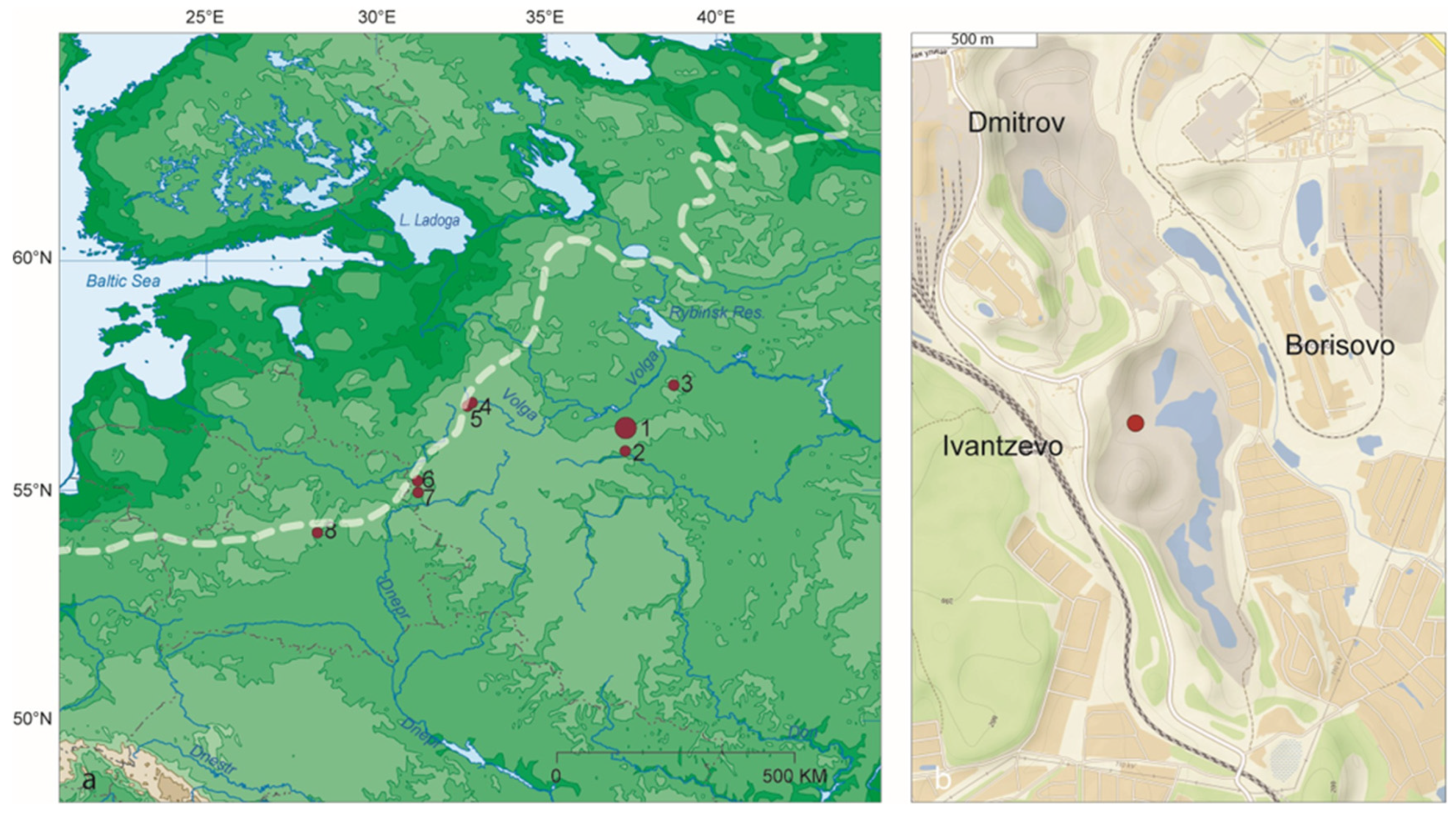
Figure 1. Location of the Ivantzevo paleontological site. (a) Localities of Mikulino Interglacial peat beds in Central Russia [23]: 1—Ivantzevo, 2—Fili (Moscow), 3—Cheremoshnik, 4—Kilelshino, 5—Bolshaya Dubenka, 6—Nizhnyaya Boyarshina, 7—Mikulino, 8—Murava; dotted white line depicts a boundary of Valdai glaciation [24]. (b) Ivantzevo quarry: position of the outcrop within a depressional area of the quarry. Map sources: (a) Eastern Europe Map—Adobe Illustrator 15.0 E-EURO-782659.ai; (b) OpenStreetMap.
Quaternary 08 00066 g001
Figure 2. Outcrop sampling scheme. (A) Outcrop in 2021 and (B) 2020. (C) Sampling for pollen in 2020 (a column of samples is marked by a white rectangle). (D) Sampling for microremains of aquatic invertebrates and pollen in 2021: DQ samples were processed for aquatic invertebrates, and the column of samples collected for pollen analysis is marked by a white rectangle. A 2021 sampling scheme: OSL (black bullets) and 230Th/U dating (black squares) samples. A 2020 sampling scheme: DM-B samples were processed for extraction of macroremains of plants, invertebrates, and charcoal, while DUT samples were processed for plant macroremains only.
Quaternary 08 00066 g002
Figure 4. Simplified pollen diagram of the Ivantzevo stratigraphic sequence. Percentages of pollen taxa are calculated relative to the total pollen sum; percentages of spore taxa are calculated relative to the combined sum of pollen and spores.
Quaternary 08 00066 g004
Figure 5. Pollen diagram (AP/NAP), local pollen zones (LPZ), affinity scores of major biomes, dominant biomes (DB), reconstructed annual precipitation (P_ann) and aridity index (AI), with correlation to marine isotope stages (MIS).
Quaternary 08 00066 g005
Figure 6. Selected plant macro-remains from the lower peat (Dm-B5): (Aa,Ab)—Potamogeton sukaczevii (endocarps); (B)—Potamogeton filiformis (endocarp), (C)—Aldrovanda vesiculosa (seed), (D)—Menyanthes trifoliata (seed); (E)—Scheuchzeria palustris (seed); (F)—Quercus robur (a fragment of an acorn); (G)—Acer platanoides (part of the fruit), (H)—Hara sp. (oogonium), (J)—Ranunculus aquatilis (achene), (I)—Hippuris vulgaris (seed).
Quaternary 08 00066 g006
Figure 7. Charcoalified plant remains from the Ivantzevo stratigraphic sequence. Top row, (AC): Ericaceae, Juniperus sp., Picea/Larix sp.; bottom row, (DF): charred root, diatoms (marked by a black arrow) deposited atop charcoal, Cenococcum sp. sclerotium.
Quaternary 08 00066 g007
Figure 8. Insects and freshwater invertebrates. (A)—Gyrinus sp. (elytron), (B)—Pelophila borealis (pronotum), (C)—Diacheila polita (pronotum), (D)—Sericoda quadripunctata (pronotum), (E)—Hydroporus morio (elytron), (F)—Agabus sp. (pronotum), (G)—Colymbetes cf. dolabratus (fragment of elytron), (H)—Cercyon impressus (elytron), (I)—Scirtes hemisphaericus ((a) pronotum, (b) elytron) (J)—Paederus littoralis (pronotum and elytra on peat), (K)—Olophrum rotundicolle ((a) head, (b) pronotum, (c) elytron), (L)—Donacia cf. dentata ((a) elytron, (b) leg), (M)—Plateumaris braccata (elytron), (N)—Longitarsus nigerrimus (body without head and pronotum), (O)—Orobitis cyaneus (elytron), (P)—Limnobaris dolorosa ((a) head and pronotum, (b) elytron), (Q)—Planaria sp. (egg), (R)—Cristatella mucedo (statoblast), (S)—Erpobdella cf. octoculata (cocoon). Samples: (A,C,D,O,S)—Dm B2; (B,G,K)—Dm B2a; (R)—Dm B3; (E,F,H,J,LN,P)—Dm B5, (Q)—Dm 443 B6.
Quaternary 08 00066 g008
Figure 9. Unusual finds of invertebrate macrofossils from Ivantzevo locality. A uniquely well-preserved leaf beetle Plateumaris braccata (A) and an egg cocoon of a spider Dolomedes sp. (B) in the lower peat unit.
Quaternary 08 00066 g009
Figure 10. Small aquatic invertebrates from Ivantzevo locality. (A)—Chaoborus sp. mandible, (BK) Cladoceran remains: (B)—Alonella exiqua, carapace, (C)—Alonella nana, carapace (the presence of 2 denticles on the valve is unusual), (D)—Acroperus harpae, headshield, (E)—filtering combs of Daphniidae, (F)—Biapertura affinis, postabdomen, (G)—Anchistropus emarginatus, carapace, (H)—Eubosmina longispina s.l., headshield, (I)—Sida crystallina, 3d exopodite segment, (J)—Chydorus sphaericus s.l., carapace; (K)—Camptocercus rectirostris, postabdomen.
Quaternary 08 00066 g010
Figure 11. Reconstruction of ecosystem dynamics during the Mikulino–Valdai transition at the Ivantzevo locality. (A) Stage 1: mixed forests with a lush Cyperaceae belt around the lake. (B) Stage 2: boreal forest with patches of tundra and steppe-tundra. (C) Stage 3: forest–tundra and steppe-tundra. (D) Steppe-tundra with forest patches. (E) Draining of the pond, frost cracking, and subsequent establishment of a new aquatic system.
Quaternary 08 00066 g011
Table 1. Pollen-based chronological correlation of Ivantzevo stratigraphic sequence with other LI/LG sequences and marine isotope stages.
Age, kaMISCorrelation with Eemian [8,9,10]Mikulino Stages, After [82]230Th/U Dates, ka [16]Proposed Chronological Outline, ka [16]230Th/U Dates, kaOLS Dates, kaLithologyIvantzevo LPZVegetation Phases (Pollen)Vegetation
60MIS4/3 53 ± 4 clayey siltLPZ 118abrupt degradation of forest cover, formation of cold steppe and tundra
70MIS5a top of upper peat LPZ 9-107boreal spruce forest
90MIS5b 70 ± 6upper peat/gittya layer sand lensLPZ 7-86gradual degradation of coniferous forests andexpansion of grassy and shrubby tundra
100MIS5c peaty clayLPZ 5-65forest recovery, initially of birch and later of mixed forests dominated by Pinus, Betula, and Picea.
110MIS5dE6-E7open landscapes, steppe elementsM8Pinus and Picea zone peaty clayLPZ 44 forest decline,
steppe elements
E5forest declineM7Picea zone (the upper maximum of Picea pollen) ~100 peaty claya combination of broad-leaved taxa/groves and open herbaceous communities
116MIS5eE4bthermal optimum (Carpinus) M6Carpinus zone108–97
M5Tilia zone (end of the Corylus peak)112–108~112105 ± 4, 113 ± 390 ± 6lower peatLPZ 33thermophilic broad-leaved forests with hazel
E4aM4bQuercus and Ulmus zone (beginning of the Corylus peak)117–112
E3oak forestM4a116–105
E2mixed forests with hazelM3Pinus and Betula zone, pollen of broadleaved taxa is present 118–112~118
E1boreal birch − pine forestM2Pinus and Betula zone127–113~126
130 M1Picea zone (the lower maximum of Picea pollen); a transition from GL to IGL 130–126~130 sandy loamLPZ 22lower maximum of spruce pollen
MIS6Late SaalianMoscow Glaciation claycold steppes dominated by Artemisia and Amaranthaceae, spruce appears
245–190MIS7 Likhvin Interglacial 259 ± 27sandy siltLPZ 11mixed forests (birch and a small proportion of conifers)
Table 2. Results of multi-proxy paleoecological analysis of Ivantzevo locality.
PhaseSample CodePlant MacrofossilsInvertebrate MacrofossilsAquatic Invertebrate Microfossils
(# of Taxa)
Aquatic Taxa (A), (#)Terrestrial Taxa (T), (#)Charred Taxa (#)A: T (MNI)A: T (Taxa)
8DM-B6 1 to 01 to 0Acroperus harpae, Biapertura (Alona) affinis, Bosmina longirostris, Chydorus sphaericus, Ephydatia sp.? Eubosmina (Bosmina) longispina, Planaria sp., Spongilla sp. (8)
Pollen-based vegetation reconstruction: abrupt degradation of forest cover, formation of cold steppe and tundra
7D-UT 7,
DM-B2, DM-B2a,
D-UT 5/1,
D-UT 5/2
Batrachium, Nuphar lutea, Ceratophyllum demersum, Menyanthes trifoliata, Myriophyllum verticillatum, Hippuris vulgaris, Sparganium sp., Potamogeton filiformis, P. natans, P. rutilus, P. sukaczevii, Scheuchzeria palustris, Schoenoplectus lacustris (13)Picea, Pinus, Betula sect. Betula, Chamaedaphne calyculata, Vaccinium oxycoccos, Rubus sp., Comarum palustre, Carex, Ranunculus sceleratus, Rorippa palustris, Chenopodium album (11)Pinus, Picea, Juniperus, Ericaceae, Cenococcum (5), concentration of micro-charcoal26 to 449 to 27Acroperus harpae, Biapertura (Alona) affinis, Bosmina longirostris, Chydorus sphaericus, Cristatella mucedo (5)
Pollen-based vegetation reconstruction: boreal spruce forest
6DM-B4,
D-UT9
Chara, Isoetes, Batrachium, Potamogeton rutilus, Najas flexilis, Menyanthes, Myriophyllum verticillatum, Hippuris, Potamogeton gramineus, P. cf. pusillus, Eleocharis (11)Betula sect. Betula, Betula nana, Rorippa palustris, Comarum palustre, Carex, Ranunculus sceleratus, Chenopodium album, Chamaedaphne, Sambucus (9) 3 to 53 to 4Acroperus harpae, Biapertura (Alona) affinis, Bosmina longirostris, Chydorus sphaericus, Eubosmina (Bosmina) longispina (5)
Pollen-based vegetation reconstruction: gradual degradation of coniferous forests and expansion of grassy and shrubby tundra
5DM-B3Potamogeton, Eleocharis (2)Chamaedaphne, Carex (2)Cenococcum sp. (1)0 to 130 to 8Acroperus harpae, Biapertura (Alona) affinis, Bosmina longirostris, Chydorus sphaericus, Eubosmina (Bosmina) longispina (6)
Pollen-based vegetation reconstruction: forest recovery, initially of birch and later forests dominated by Pinus, Betula, and Picea.
4/5Pollen-based vegetation reconstruction: forest decline
4DM-B1Menyanthes, Potamogeton rutilus (2)Comarum, Carex (2)Cenococcum sp. (1), micro-charcoal9 to 52 to 5Acroperus harpae, Biapertura (Alona) affinis, Bosmina longirostris, Chydorus sphaericus, Eubosmina (Bosmina) longispina (5)
Pollen-based vegetation reconstruction: a combination of broad-leaved groves and open herbaceous communities
3DM-B5Aldrovanda vesiculosa, Menyanthes, Scheuchzeria, Eleocharis (4)Quercus, Corylus, Acer, Sambucus, Picea, Chamaedaphne, Vaccinium, Carex (8) 36 to 13111 to 36Acroperus harpae, Biapertura (Alona) affinis, Bosmina longirostris, Chydorus sphaericus (4)
Pollen-based vegetation reconstruction: thermophilic broad-leaved forests with hazel
2 Acroperus harpae, Biapertura (Alona) affinis, Bosmina longirostris, Chydorus sphaericus, Ephydatia sp.?, Eubosmina (Bosmina) longispina, Spongilla sp. (7)
Pollen-based vegetation reconstruction: cold steppes dominated by Artemisia and Amaranthaceae, spruce is present
Disclaimer/Publisher’s Note: The statements, opinions and data contained in all publications are solely those of the individual author(s) and contributor(s) and not of MDPI and/or the editor(s). MDPI and/or the editor(s) disclaim responsibility for any injury to people or property resulting from any ideas, methods, instructions or products referred to in the content.