Article

Late Holocene Abrupt Changes in the Fluvial Dynamics of the Tiber Valley Catchment (Rome, Italy): An Impact of the 4.2 Event?

1
Istituto Nazionale di Geofisica e Vulcanologia, 00143 Rome, Italy
2
SIGEA Lazio, APS, 00100 Rome, Italy
*
Author to whom correspondence should be addressed.
Quaternary 2025, 8(4), 59; https://doi.org/10.3390/quat8040059
Submission received: 31 July 2025 / Revised: 14 October 2025 / Accepted: 20 October 2025 / Published: 23 October 2025

Abstract

In the present work, we investigate the post-glacial aggradation of three tributary valleys draining the left hydrographic basin of the Tiber River in central Rome: the Murcia, Caffarella, and Grottaperfetta valleys. We describe the Upper Pleistocene–Holocene stratigraphic record of the alluvial successions occurring in the Caffarella Valley through the core data collected in a dedicatedly performed 35 m deep borehole. We provide seven 14C age constraints to the sediment aggradation which allow us to make a comparison with the Grottaperfetta and Murcia valleys, for which we present previously unpublished borehole data, and with the Tiber River Valley investigated in the previous literature. In particular, we highlight the effects of a mid-Holocene (5200–3800 yr BP) erosional phase, partially overlapping with the global 4.2 ka cooling/drying event, and we discuss the possible occurrence of a sea level fluctuation linked with this paleoclimatic event which has not been detected so far by other sedimentary records. Finally, we provide evidence for the widespread occurrence of a 6th century BCE (2550–2450 yr BP) overflooding phase that was previously observed only in the eastern portion of the Tiber River Valley in central Rome, which we suggest may be originated by concurrent intensive deforestation activity in central Italy.

1. Introduction

The alluvial sedimentary successions of large rivers represent fundamental stratigraphic archives for the study of climate change and human impact on floodplain evolution during Holocene times (e.g., [1,2,3,4,5]). Sediment aggradation in the incised fluvial valleys is strictly paced with the sea level rise following the end of the Last Glacial Maximum and is sensitive to regional control, including climate and relative sea level, as well as to local factors, such as river dynamics, tectonic impact, and anthropic activities (e.g., [6,7,8,9,10]). A major hinderance to the reconstruction of sedimentary events and their dating is the lack of exposed natural geological sections, which is overcome through the use of facies analysis on seismic profiles (e.g., [11]) and the integration of borecore data. In this work, we present the study of the entire post-glacial aggradational succession of three major tributary valleys of the Tiber River in Rome, which has been performed through the analysis of drill cores.
Three small tributary valleys drain the surface waters within the left hydrographic basin of the Tiber River in central Rome; from north to south, these are the Murcia, Caffarella, and Grottaperfetta valleys (Figure 1a).
These valleys affect the pyroclastic plateau forming the northeastern sector of the Colli Albani Volcanic District and are characterized by narrowly SE–NW elongated catchment basins, a feature arising from inherited tectonic control by the main buried faults which were active during Quaternary times in this region [12] (and ref. therein).
Relatively wide and short alluvial plains occupy the lowest portion of the catchment basins, while small creeks characterized by non-depositional streambeds flow within narrow incisions affecting the upstream portions of these basins (Figure 1b). The focus of the present work is on the post-glacial aggradational history of these alluvial valleys, reconstructed by means of chronostratigraphic and sedimentologic analysis on sediment cores, and the implications for the Holocene climate, the sea level fluctuations, and the anthropic activity.
Previous studies provided a detailed reconstruction of the sedimentary events which occurred in the Tiber Valley in Rome [6,13,14,15,16,17], highlighting the deposition of a more than 40 m thick package of fine sediments (clay, silt, and subordinated sand). Rapid aggradation occurred throughout the terminal tract of the Tiber Valley and the coastal plain from ~13,000 to ~5300 yr BP, in response to the fast sea level rise since the Last Glacial Termination [6,11,18,19].
A sharp decrease in the rate of sea level rise occurred from 8000 to 6000 yr BP [8], and by 5500 yr BP the local sea level reached an elevation close to the present one, leading to the establishment of an alluvial plain at ca. 1 m a.s.l. in Rome [6,16]. Starting after 5300 yr BP until 4500 yr BP, a re-incision several m deep of this early alluvial plain occurred, which was re-filled from 4400 to 2800 yr BP (corresponding to the Bronze–Iron Age in peninsular Italy), when the alluvial plain rose again at ca. −1 m a.s.l. The causes of this erosional event are uncertain and may be linked with a sea level drop which originated by regional vertical tectonic movements, as well as with a hydrological/climatic event (see [6] for an in-depth discussion). On the other hand, hydrologic processes commonly occurring within the fluvial and deltaic system (e.g., low sediment supply/discharge ratio) may lead to fluvial incision, as argued in the Discussion section.
A relatively stable landscape characterized the Archaic period in Rome during the 8th and 7th centuries BCE (2800–2600 yr BP), while a dramatic paleogeographic change occurred during the 6th century BCE, when sudden and recurrent floods of the Tiber River caused an up to 6 m rise in the alluvial plain in about one century (ca. 2550–2450 yr BP [16,17]). Such rapid aggradation dramatically changed the hydrography of this portion of the river valley and, possibly associated with fault displacement, ultimately led to the birth of the Tiber Island at the end of the 6th century BCE [16,17].
Repeated, yet less large, flooding events occurred throughout the Republican period, causing a progressive uplift of the alluvial plain, from ca. 6 m to 9 m a.s.l., by the 1st century BCE [16,17,20,21,22,23]. During this time span, several anthropic interventions raised the ground level to prevent the continuous flooding of the ancient city.
In the present work, we describe the complete post-glacial alluvial successions within these three tributary valleys through the core data collected in a newly performed 35 m deep borehole in the Caffarella Valley and previously unpublished borehole data from the Murcia and Grottaperfetta Valleys. We provide seven 14C age constraints to the sediment aggradation in the Caffarella valley which allow us to make a comparison with the Grottaperfetta, Murcia, and Tiber River Valleys investigated in the previous literature [6,16,17,24]. In particular, the focus is on highlighting the effects of the mid-Holocene (5300–3800 yr BP) erosional phase [6] and on the 6th century overflooding phase that are recorded in the Tiber River Valley [10,16,17].

2. Geologic Setting

According to tradition, the City of Rome was built upon seven tuffaceous hills on the eastern bank of the Tiber River. Indeed, these topographic heights are the remnants of a mid-Pleistocene pyroclastic plateau eroded by the Tiber River and its tributaries during periods of sea level fall and concurrent regional uplift [25] (and references therein).
This area was characterized by marine sedimentary conditions during Pliocene through to Early Pleistocene times. Magma uprising in the underlying crust was responsible for progressive upwelling, which led to continentalization with the establishment of a paleo-Tiber delta since ca. 800 kyr BP [26,27,28], concurrently with the start of the volcanic activity of the highly potassic “Roman Magmatic Province” [29]. Huge pyroclastic-flow deposits, several-ten km3 in volume, and subordinated air-fall deposits were erupted in the interval of 600–36 ka by the Monti Sabatini and Colli Albani volcanic districts, located NW and SE of Rome, respectively [30,31,32,33,34,35,36,37]. These stratified volcanic deposits, represented by tuff, pozzolan, and ash, form the geologic substrate in the morphologically higher sectors, whereas they are partially eroded and intercalated with sedimentary deposits within the paleo-incisions [38,39].
During Middle–Late Pleistocene and Holocene times, the sedimentary processes in the area of Rome were restricted in the fluvial channels and coastal plain and were controlled by the interplay among sea level changes linked to glacio-eustatism, volcanic activity, and tectonics [25,38,40].
A well-defined hydrographic network is present in the area of Rome in consequence of the ~50 m tectonic uplift that occurred in the last 250 kyr [41,42,43,44], causing the alluvial valleys to display prominent and steep banks bordering the floodplains. These marked features are partially obliterated in the urban area, where more than 2000 years of anthropic activity deeply modified the original morphology [45,46].

3. Materials and Methods

The sedimentological and chronostratigraphic features of the sedimentary successions of the Murcia, Caffarella, and Grottaperfetta valleys have been investigated by means of the following:
  • one 35 m deep borehole (CAF-S2) drilled in the Caffarella Valley (Figure 1) aimed at recovering the complete post-glacial alluvial succession, drilled by Fondazione Amici di Italia Fenice as part of a Geological Monograph Project on the Caffarella Valley and with the permission of the Ente Regionale Parco dell’Appia antica and of the Parco Archeologico dell’Appia antica;
  • data from the literature [24] and previously unpublished stratigraphic data from a drilling campaign performed by the INGV in collaboration with the local Department of Civil Protection, which have been used for the reconstruction of the aggradation phases in the Grottaperfetta Valley (Figure 1);
  • six previously unpublished borehole data drilled in the Murcia Valley by the Sovrintendenza Capitolina which integrate previous drilling campaigns [47,48].
Since the aim of the present work is to assess the timing of sediment aggradation within the alluvial valleys, and we do not discuss hydrologic processes and fluvial dynamics, no detailed sedimentologic study (i.e., granulometric analysis, facies analysis) is performed here, for which we remand the reader to the previous literature [6,13,14,18,19].

14C Dating

Seven organic samples were selected from the sedimentary succession recovered in the Caffarella valley for 14C absolute dating and processed at the Beta Analytic Laboratory (Miami, USA). Radiocarbon ages are reported in calibrated year before present (cal yr BP) throughout the paper. Similarly, ages referred to historical periods are reported in yr BP, while ages referred to geologic periods and for chronostratigraphic purpose are expressed in kiloyears ago (ka).

4. Results

4.1. CAF-S2 Borehole Stratigraphy

One 35 m deep borehole was drilled at the centre of the Caffarella valley, 2 km inland of its confluence in the Tiber Valley (Figure 1b), aimed at recovering the full post-glacial alluvial succession. Continuous core drilling was carried out, in accordance with the nature of the materials traversed, using a traditional system consisting of a set of rods and simple core barrels with an external diameter of 101 mm, ranging in length from 1.50 to 3.00 m, with dry advancement for better recovery of less coherent or altered soils.
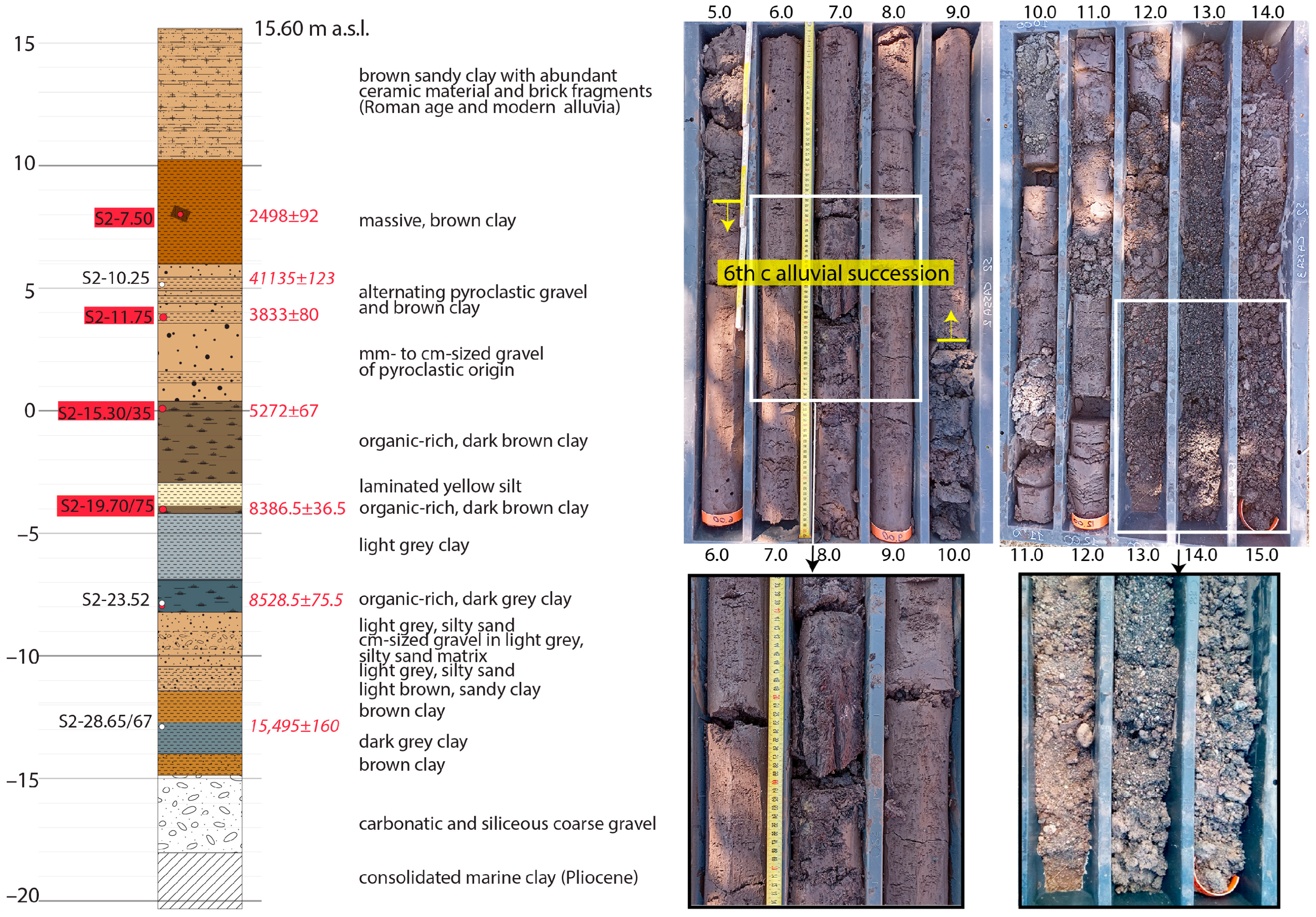
The sedimentary succession (Figure 2) is constituted by a basal, ca. 3 m thick coarse gravel layer between −18 and −15 m a.s.l., abruptly passing upward to a clayey succession, 3.5 m thick. A sandy clay interval with a medium-sized gravel layer occurs between −11.5 and −8.2 m a.s.l. and is followed by an 8.5 m thick clay succession with frequent peat layers. A ~3 m thick, mm- to cm-sized gravel layer of volcanic origin occurs between 0.3 and 3.5 m a.s.l., followed by alternating pyroclastic gravel and clay layers between 3.5 and 6 m a.s.l. A massive, brown clay horizon occurs between 6 and 10.3 m a.s.l., followed by a 5.3 m thick sandy clay horizon with abundant ceramic materials and brick fragments. Seven samples for 14C dating have been collected at different elevations to provide age constraints to the alluvial succession.

4.2. 14C Dating

Results of the 14C dating are summarized in Table 1. Four ages performed on wood, seeds, and plant materials (S2-7.70, S2-11.75, S2-15.30/35, S2-23.52) are considered highly reliable ones and provide tight chronological constraints to sediment aggradation in the Caffarella Valley. Three other ages on organic sediment in some cases show stratigraphic inconsistency (e.g., S2-10.25/30) or evident postdating (e.g., S2-28.65/67) and are not considered representative of the sediment age. Indeed, bulk sediment samples for radiocarbon dating frequently yield ages clearly exceeding the depositional timeframe due to the occurrence of organic material of older origin (e.g., [49]).

4.3. Chronostratigraphic Reconstruction

In the present study, the stratigraphy of the cored sedimentary deposits is described according to the macroscopic sedimentologic features characterizing the main alluvial successions identified in previous studies [10,16,17,48]:
  • Basal gravel layer (~18.0–13.0 ka). Coarse (Ø ≤ 10 cm) gravel constituted by mainly limestone and chert, and subordinated pyroclastic, well-rounded pebbles, in sandy matrix.
  • Pre-Bronze Age alluvial succession (~13.0–5.3 ka). Grey clay with diffused organic material (peat layers, charred wood, and vegetal remains), subordinated sand.
  • Bronze–Iron Age alluvial succession (~4.5–2.8 ka). Yellow sandy clay and silt, with rare organic-rich mm-thick layers, with medium sized gravel (Ø ≤ 5 cm) at the base.
  • 6th Century alluvial succession (~2.55–2.45 ka). Light grey to yellowish clay, sometimes thinly laminated, devoid of anthropic and organic material, with a ~10 cm thick layer of fine gravel (Ø ≤ 2 cm) including sub-angular tuff and ceramic fragments at the base.
  • Early Republican to Modern Age alluvial succession (<2.45 ka). Heterogeneous yellow to brown sandy clay sediments, including frequent fragments of anthropic materials.
For detailed sedimentologic and granulometric analysis of the alluvial sediments constituting the pre-Bronze Age, the Bronze–Iron Age, and the 6th century BCE successions, we remand the reader to [10,17].

4.3.1. Murcia Valley

The Murcia Valley drains a very small catchment basin in central Rome, which affects the flanks of the Palatine, Aventine, and Coelium hills (Figure 1). However, before intervening anthropic modifications, the extension of the original drainage basin drained by the Murcia Valley might have been much larger, including the ca. 16 km long Aqua Mariana stream and a series of watercourses converging in the northwestern tributary branch of the smaller basin (Figure 1), as discussed in [25].
The alluvial plain of the Murcia Valley is confined in the lowest portion of the catchment basin, drained by only a 2.4 km long watercourse characterized by a straight SE–NW direction and elevation gain of ca. 22 m from the highest point, corresponding to the saddle upon which the Porta San Sebastiano of the Aurelian Walls is located, to its confluence with the Tiber River. Remarkably, the lower portion of the alluvial valley hosts the remains of the Circus Maximum, where in Roman times the famous chariot racing track was located.
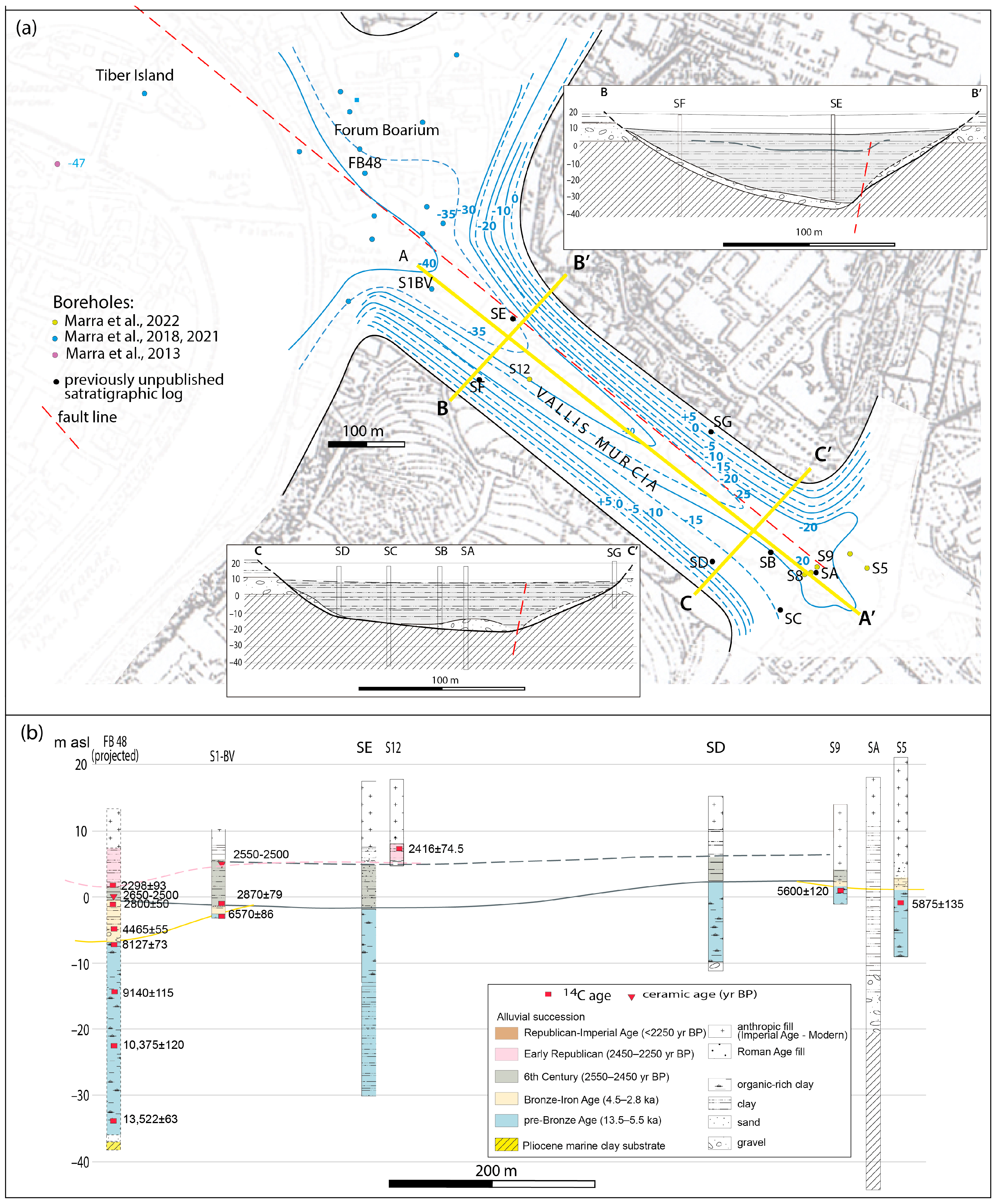
Six unpublished stratigraphic logs performed by the Soprintendenza Capitolina integrate previous chronostratigraphic constraints provided by [17,47,48] to sediment aggradation in the Murcia Valley (Figure 3).
The above-mentioned data allow us to reconstruct an isobath map of the bottom of the alluvial succession (Figure 3a), two transversal profiles highlighting the asymmetrical shape of the valley’s flanks (insets in Figure 3a), and the longitudinal profile showing the gradient of the valley during the Last Glacial Maximum, 20–18 ka.
Upper and lower 14C age constraints provided by the boreholes S12 and BV-S1 (i.e., 2416 ± 74.5 and 2870 ± 79 yr BP, respectively, [17,48]) allow us to attribute the ca. 8 m thick package of clayey sediments comprised between −2.7 and ca. 5 m a.s.l. to the 6th century alluvial succession, in analogy with observations in the Foro Boario area [16,17] (Figure 3b).
The direct overlying of the 6th century alluvial succession on the pre-Bronze age succession confirms previous inferences in [48] about the lack of significant Bronze Age sedimentation in the Murcia Valley, consistent with the occurrence of a regressive phase in the interval of 5.3–4.4 ka and the successive partial re-filling, from 4.4 to 2.8 ka, of an erosive incision that affected only the Tiber Valley (see borehole FB 48 in cross-section of Figure 3b).
The interpretative transversal cross-sections (B-B’ and C-C’ in Figure 3a) account for the asymmetric shape of the valley incision highlighted by the isobath map, consistent with the position of an inferred fault line hypothesized in [16,17]. They also show the source of the basal gravel layer at the bottom of the alluvial succession in the ca. 10 m thick gravel horizon of the Middle Pleistocene Paleotiber Unit [38], corresponding to the aggradational succession deposited in response to sea level rise during MIS 15 [25] (and ref. therein). Unlike the basal gravel of the alluvial succession filling the Tiber Valley, representing the output of the erosion of the silicic-carbonatic rocks of the Apennine’s mountain range, the gravel in the tributary valleys in Rome is an outcome of the re-erosion of previously deposited gravel by the Paleotiber. Indeed, the catchment basin of these tributary valleys is confined within the western sector of the Colli Albani Volcanic District, where no silicic-carbonatic rocks outcrop and the Paleotiber Unit is the only possible source of gravel, which was eroded when the alluvial incisions deepened to reach its elevation.

4.3.2. Caffarella Valley

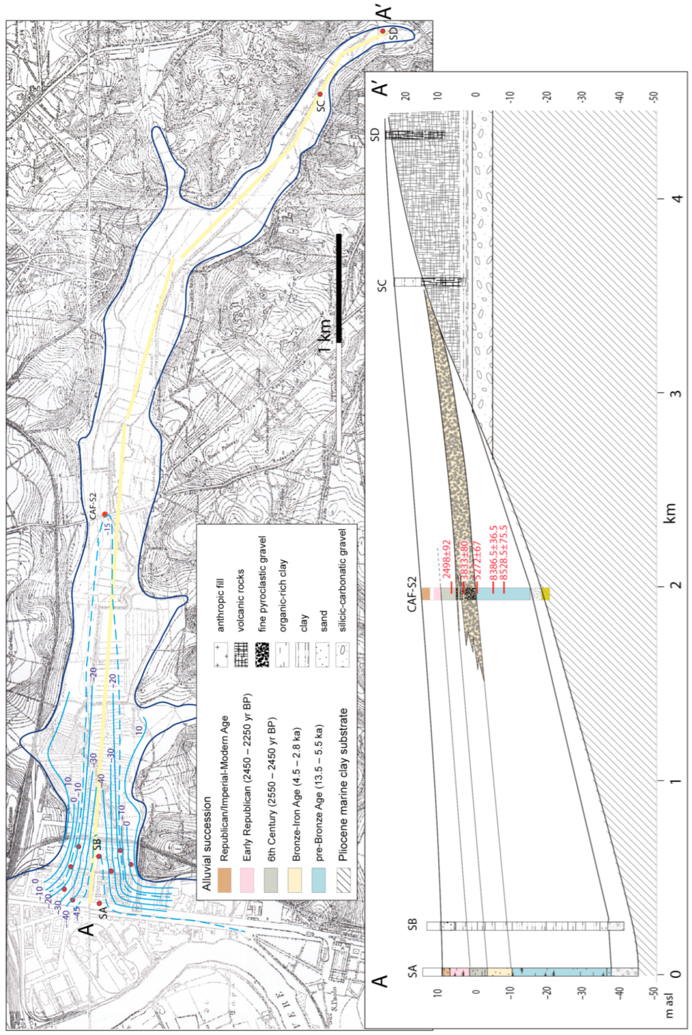
The 5.3 km long Caffarella alluvial valley is characterized by an elevation gain of 15 m and consists of two differently oriented tracts: an E–W oriented lower tract and a SE–NW upper tract. The main watercourse is named Almone River in the lower basin, while it is called Caffarella stream in its upper portion. No evident alluvial plain occurs in the higher portion of the hydrographic basin (southeast of the triangle in Figure 1a), suggesting an erosive, non-depositional feature, consistent to the much steeper gradient. Accordingly, available borehole data highlight the lack of significant alluvial deposits in this sector (Figure 4).
The dedicated CAF-S2 borehole allowed the recovery of the complete post-glacial sedimentary succession, highlighting the occurrence of a coarse-grained interval within the Bronze Age alluvial successions, between 0.5 and 3.4 m a.s.l., which has not been observed in the Murcia and Grottaperfetta tributary valleys. Similarly, a lower coarse-grained interval occurs below the organic-rich upper portion of the pre-Bronze Age alluvial succession. It is constituted by pebbles of volcanic rocks (mainly lava and subordinately tuff), up to 4 cm in diameter, within a brown silty sand matrix. Such a 1.5 m thick layer accounts for an increase in capacity of transport by the Almone River in a period shortly preceding 8528.5 ± 75.5 yr BP, a time when the deposition of a 1 m thick peat layer marked a sudden environmental change, with the establishment of palustrine conditions.
Above it is a 2 m thick layer of homogeneous light grey clay, topped by another 20 cm thick peat layer providing an age constraint of 8386.5 ± 36.5 yr BP, accounting for a high sedimentation rate. It is followed by a 2 m thick package of yellowish, thinly layered silt, suggestive of a slowing in sedimentation rate and intervening redox conditions. It follows an organic-rich, light brown clay layer which marks the late stage of deposition of the pre-Bronze age alluvial succession, constrained by the 14C age of 5272 ± 67 yr BP at the top.
Most significantly, a ~3 m thick package of medium-fine gravel, constituted by ≤2 cm pyroclastic pebbles in a coarse sand matrix (Figure 2 and Figure 4), is emplaced between 5272 ± 67 and 3833 ± 80 yr BP, a period corresponding to the so-called “mid-Holocene transgressive phase” observed in the Tiber Valley [6,16]. While the term transgression attains to a geologic event where sea level rises relative to the land and the shoreline moves inland, in the case of the Tiber River it has been used to suggest a direct link between the occurrence of an erosional phase incising a previously established alluvial plain, followed by a new aggradational phase filling the re-incised valley, and a previously undetected sea level oscillation (see [6,16] for an in-depth discussion).
Also, remarkably, a 4 m thick layer of massive, homogeneous bright brown clay occurs above this Bronze Age gravel horizon. A Salix sp. trunk fragment conglobated within this clay horizon (Figure 2 and Figure 4) provided a 14C age of 2498 ± 92 yr BP, evidencing the exact match between the time of deposition of this 4 m thick clay package and the overflooding phase responsible for the rapid accumulation of ca. 6 m of alluvial deposits in the Tiber Valley, between the 6th and the 5th century BCE.

4.3.3. Grottaperfetta Valley

The catchment basin of the Grottaperfetta Valley displays very similar features as that of the Murcia and Caffarella Valley. It is a very narrowly SE–NW elongated, ca. 8 km long sector, bounded to the NE by the ancient Appia Road which runs along the hydrographic divide (Figure 1).
As for the other two valleys, a wide alluvial plain occupies only the lowest portion of the catchment basin (Figure 5). In particular, a larger, 1.5 km long terminal sector has been interpreted to constitute a tectonic basin (graben) generated in Holocene times by two antithetic NW–SE faults [24]. The stream flowing within this portion of the valley is named Grottaperfetta, while in the upper portion it takes the name of Tor Carbone. When this longest branch is also considered, the alluvial valley is ca. 3 km long with an elevation gain of ~14.5 m, while the non-depositional upper catchment basin is characterized by an elevation gain of ~70 m in 5 km.
Eight 14C ages performed by [24] constrain aggradation of the pre-Bronze Age alluvial succession in the Grottaperfetta valley between 16,840 ± 400 and 5755 ± 155 yr BP (Figure 5). A ninth radiocarbon age evidences a sedimentary hiatus between 5755 ± 155 and 3695 ± 145 yr BP, encompassing the “mid-Holocene transgressive phase”. The deposition of a ca. 10 m package of clayey sediments accounts for the reprise of rapid aggradation after 3700 yr BP. Re-analysis of the original stratigraphic reports performed for the present study allowed us to recognize the previously unidentified 6th century alluvial succession recovered by the borecores in the Grottaperfetta Valley. This is constituted by a ca. 6 m thick package of greenish clay with convoluted lamination passing upwards to dark brown silt with idiosyncratic nodules of light grey/greenish clay (see [16,17]), between 0 and 6.5 m a.s.l. (Figure 5). The sedimentologic features of this horizon suggest that the 6th century alluvial succession overlies the peat layer dated 3695 ± 145 yr BP, directly, highlighting the lack of significant Bronze Age sediments in this section of the Grottaperfetta Valley, as also observed in the Murcia Valley.
The original stratigraphic reports of the borehole IR drilled in the southern part of the Tiber Valley in Valco San Paolo [14] (Figure 1) have been re-analyzed in the present study, aimed at discriminating between the Bronze/Iron Age and the 6th century alluvial successions. A basal horizon of dark grey, coarse sand with repeated medium-sized (≤2 cm) gravel layers, ca. 9 m thick, characterizes the Bronze Age alluvial succession at elevation ranging from −10.3 to −2 m a.s.l. (see Figure 6) and it is constrained by a 14C age of 4020 ± 120 yr BP close to its base. Above it, another 9 m thick package of homogeneous light brown/yellow sandy silt, with an 80 cm thick coarse sand layer at the base, occurs. We tentatively attribute this horizon to the 6th century alluvial succession, based on its elevation comprised between −2 and 8 m a.s.l. and its lateral correlation with the equivalent horizon occurring in the Grottaperfetta Valley (Figure 6). However, the sedimentologic description alone does not allow discriminating it from the similar Bronze/Iron Age package of sandy silt deposits, which occurs in the Tiber River Valley [17].

5. Discussion

5.1. Reconstruction of the Aggradational Phases and Correlation with the Main Tiber Valley

5.1.1. Mid-Holocene Erosional Phase

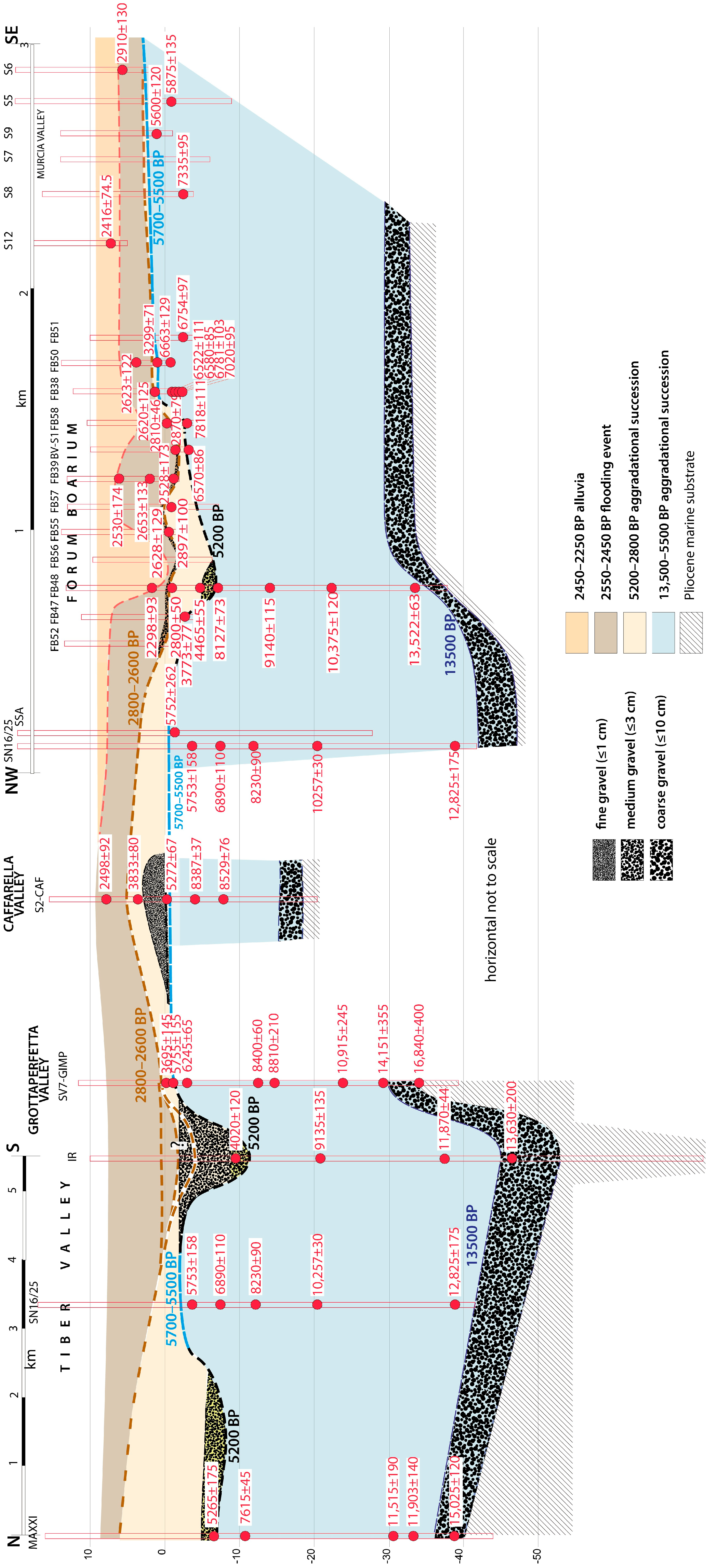
A synopsis of the chronostratigraphic data constraining sediment aggradation in the three investigated tributary valleys and the Tiber Valley is provided in the composite cross-section of Figure 6. The left part of the figure shows a longitudinal, N–S profile of the Tiber Valley between northern Rome (MAXXI borehole) and Valco San Paolo (IR borehole), and its lateral connection with the Grottaperfetta Valley (borehole SV7-GIMP) (see Figure 5). The right part of the figure shows a SE–NW profile along the Murcia Valley and through the Foro Boario area, to reach the mid portion of the Tiber Valley (borehole SN16/25) met by the previous profile. Finally, the stratigraphy of borehole CAF-S2 drilled in the Caffarella Valley is reported at the centre of the figure.
Three gravel horizons, characterized by different grainsize, occur at different chronostratigraphic heights. A coarser gravel layer (ø of the pebbles ≤ 10 cm) marks the transgression at the end of the Last Glacial Maximum. As extensively debated in the previous literature [6,50], this gravel horizon is accumulated mainly during the Last Glacial Termination, from 15,000 to 13,500 yr BP, and the abrupt switch to the overlaying clay section matches the sudden loss in water transport capacity coincident with Melt-Water Pulse 1-a [51].
Rapid sediment aggradation since 13,500 yr BP, concurrent with the fast sea level rise corresponding to the Glacial Termination, led to the deposition of up to 40 m of clayey sediments, accounting for an average sedimentation rate of ~5 mm/yr, and to the establishment of an alluvial plain at around the present-day sea level, by 5500 yr BP. Remarkably, elevation of this early alluvial plain is rather constant throughout the investigated portion of the catchment, ranging +3/−3 m a.s.l., showing a very small gradient between the tributary valleys and the lowest part of the Tiber Valley. Such a feature calls for widespread palustrine environmental conditions, in which a flat marshy sector affected the Tiber basin from the coastal plain through its upper portion, 30 km inland. As opposed to this low-energy environment, a second gravel layer with a diameter of the pebbles of ≤5 cm fills deep incisions cutting through the 5500 yr BP alluvial plain. While the incised morphology may reflect in part the occurrence of a channel hosting the riverbed, the elevation gain attaining to ca. 10 m between the levee and the bottom of the channel (see borehole IR in Figure 6) suggests a significant lowering of the base level in the catchment basin. Indeed, the bottom of the incision reaches—12 m a.s.l., a too-low elevation compared to the sea level of 5200 yr BP, which in the central Tyrrhenian Sea is estimated between −2 m and −3 m a.s.l. [8] (Figure 7).
Such low elevation cannot be entirely explained by sediment compaction leading to a generalized subsidence within the Tiber Valley, as estimated by computation of such a phenomenon in [6]. Similarly, estimations in the Tiber delta area by [1] suggested a negligible subsidence during the last 5000 yr BP, estimated in less than 0.6 mm yr−1.
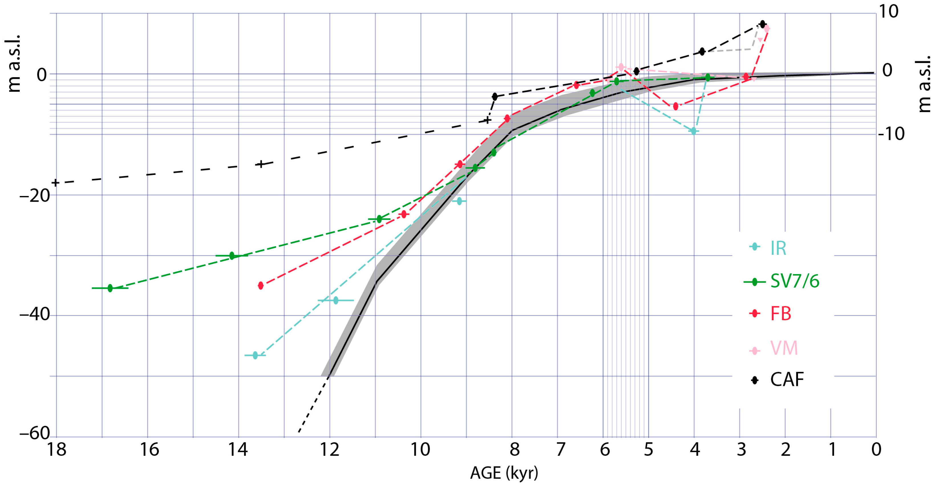
The occurrence of a lowering of the base level is inferred also from the comparison of the aggradational curves for the investigated tributary valleys and the Tiber Valley with a sea level curve for the central Tyrrhenian Sea [8] in Figure 7. It must be remarked that the relationship between the global sea level curve and the curve of sediment aggradation in a fluvial valley reflects a series of complex factors, and the only constant feature is that the second curve (terrestrial record) must overlay the first one (sea level). With this premise in mind, we note that both the aggradational curves for the Tiber Valley at Foro Boario and in Valco San Paolo show elevation below the present sea level at 4500–4000 yr BP, during the erosional phase, while such a feature is not observed in the three investigated tributary valleys, consistent with the observed sedimentary stasis and lack of erosion, as discussed ahead.
Analyzing the causes of the possible lowering of the base level is beyond the scopes of the present work, where we are interested in describing the sedimentologic aspects and providing precise geochronologic constraints to this high-energy hydrologic phase. However, we remark that a such time interval is broadly synchronous with the so-called “4.2 ka Event” (e.g., [52], and references therein), as discussed in the next section. Moreover, evidence for forced regression linked with sea level fall has been suggested by [6], who correlated the transgressive phase with a drastic change in the sedimentary supply in the Tiber delta characterized by a marked increase in grainsize around 4300 yr BP and a re-incision of the 6000–5350 yr BP alluvial plain inferred from data in [19].
We remark that such complete sea level fluctuation cannot be explained by tectonic or GIA effects, as highlighted in other regions of the world to explain a sea level peak at ~4000 yr BP followed by regression (e.g., [53]).
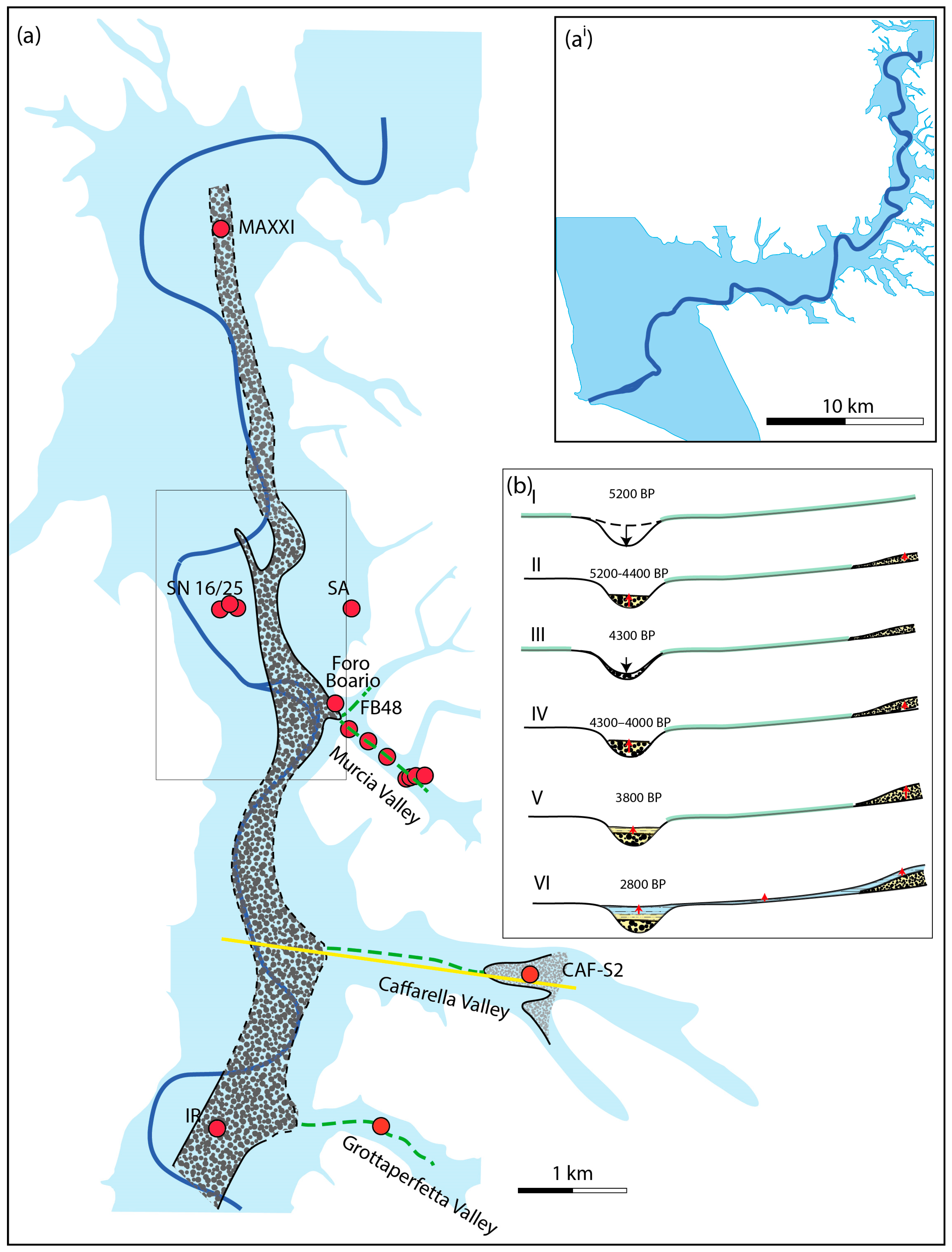
In Figure 8, the reconstruction of the river channel affected by (re)-incision and gravel deposition in central Rome based on borehole data by [13] (grey rectangle) is extended north and south, correlating it with MAXXI and IR borehole data.
Combined 14C age data seem to provide very strict post quem and ante quem termini of 5272 ± 67 yr BP (top of pre-Bronze age clay in CAF-S2) and 5265 ± 175 yr BP (bottom of gravel in MAXXI) to the maximum deepening of river incision and to the start of gravel deposition (Figure 6). In contrast, 14C ages provide contradictory indications on the time of cessation of gravel accumulation.
In the Caffarella Valley, the deposition of a 4 m thick gravel horizon is constrained between 5272 ± 67 and 3822 ± 80 yr BP. A wood sample close to the base of the gravel in borehole IR provides an age of 4020 ± 120 yr BP, while in borehole FB48 a peat sample provides an ante quem of 4465 ± 65 yr BP to the end of gravel accumulation. A possible interpretation is that two distinct gravel layers were emplaced, linked with two consecutive erosional phases which occurred in the interval of ~5200–3800 yr BP in the Tiber Valley (Figure 8b). An early erosional phase between 5265 ± 175 and 4465 ± 65 yr BP is the one recorded at MAXXI and FB48 boreholes (Figure 8bi–ii), while a second one which occurred between 4465 ± 65 and 3833 ± 80 yr BP is recorded at borehole IR (Figure 8biii–iv).
Remarkably, the larger time interval broadly corresponds to a time of non-deposition in the Grottaperfetta Valley (sedimentary hiatus between the two peat layers dated at 5755 ± 155 yr BP and 3695 ± 145 yr BP in borehole SV7-GIMP). Similarly, sediments younger than 5600 yr BP attributable to the mid-Holocene erosional phase are lacking in the Murcia Valley, where less than 1 m of clayey sediments of the Bronze–Iron Age aggradational phase are recognized [48]. In contrast, borehole CAF-S2 evidences the deposition of a 4 m thick gravel horizon in the mid-portion of the Caffarella alluvial valley in this time interval (Figure 4 and Figure 8b).
Profiles in Figure 8bi–vi provide an interpretation of the hydrologic context of the investigated tributary valleys, in which sedimentation stasis and gravel deposition occurred. The sedimentation stasis affecting the tributary valleys is represented in Figure 8bi–bv by the thick green line (dashed in Figure 8a), which in the Caffarella Valley it connects the two portions of the catchment basin affected by gravel deposition during the 5200–4000 yr BP interval. The alternative hypothesis that the gravel horizon may be the filling of a narrow, continuous stream channel running all along the Caffarella Valley is unlikely. Indeed, despite the lack of stratigraphic evidence in the Caffarella Valley, the large number of boreholes drilled in the Murcia Valley and those depicting a transversal transect in the Grottaperfetta Valley suggest the lack of any stream channel filled with gravel. The following interpretation of the hydrologic dynamism affecting the Tiber River and its tributaries in this time span can be inferred, based on the observations described above.
A marked (in the order of several metres) lowering of the base level (i.e., relative sea level) triggers fluvial incision in the Tiber Valley and the enhanced water transport capacity allows for medium-sized gravel transport and accumulation within the fluvial channel (Figure 8bi). Contrasting age constraints on this gravel suggest that two consecutive such events may have occurred in the time span of 5200–3800 yr BP (Figure 8bi–iv). The limited time span during which each one of these such sea levels fall endured, and the retrograde character of the phenomenon, is the reason why the tributary valleys are not affected by the erosive phase, significantly, and are characterized by non-deposition in their terminal tracts during this period. In contrast, the increased water transport capacity is supposed to cause the accumulation of fine gravel eroded in the upper portion of the catchment in correspondence to the marked slope variation occurring at the inner edge of the flat terminal tracts of the investigated tributary valleys (Figure 8bii–vi). This fact may explain the gravel horizon recovered in borehole CAF-S2 in the medium-upper tract of the Cafarella Valley.

5.1.2. The 4.2 ka Event

The so-called “4.2 ka BP Event” is the most marked and debated multidecadal- to century-scale climatic event recognized during Holocene times (for an exhaustive review see [52], with references). Such an event is recognized by a widespread set of indicators (e.g., pollen records, speleothems, lake and marine sediments), mostly in the Mediterranean region, providing evidence for a prolonged cool and dry interval (e.g., [54,55,56]), which has been proposed to represent a global “megadrought” [57,58]. Although not all the palaeoclimatic records preserve evidence of the 4.2 ka BP Event, and not necessarily as a cold and dry event, the global-scale significance of this climate event has been accepted recently as the formal boundary of Late and Middle Holocene at 4250 ka [52].
However, the exact timing and duration of this event is poorly constrained, showing a rather large variability among the different records and regions. Some authors [59,60] have also proposed that this event consisted of a complex succession of dry/wet events, rather than a single long, dry event. In this regard, [52] have indicated a period of time between approximately 4.3 and 3.8 ka cal BP which does not necessarily correspond to the true duration of the climatic event but reflects the chronological interval where this event is most commonly recognized.
Remarkably, the 4.3–3.8 ka interval corresponds to the youngest part of the period of gravel deposition in the Tiber catchment, which the 14C ages presented in this paper constrain between 5200 and 3800 yr BP. However, given the poorly constrained, contrasting age interval for the global evidence of the 4.2 ka Event [52], the MAXXI age may be regarded as suggesting an earlier beginning and longer duration for this climate event, as well as the occurrence of a distinct, earlier similar paleoclimatic event around 5200 yr BP.
Indeed, several periods of significant rapid climate change, characterized by polar cooling, tropical aridity, and major atmospheric circulation changes, are recognized during the last 9000 yr [61,62], and cold periods seem to concentrate around 5500 and 4500 yr BP, a time span roughly coincident with the indications of the regressive phase occurring in the Tiber Valley. In particular, several examples of evidence for a worldwide, strong climatic cooling at around 5500 yr BP, marking the Hypsithermal/Neoglaciation transition [63], are found in the scientific literature (e.g., [64,65,66,67,68]). Remarkably, the coastal lake of Maccarese [69] at the mouth of the Tiber River records an abrupt change around 5400 cal yr BP, marking the transition to a marshy environment, due to a lowering of the water table [70], and it dried up at ca. 4500 yr BP [71]. Due to the proximity to the coast of the Maccarese Lake, the occurrence of a dry period does not explain such lowering of the water table, and this phenomenon appears consistent as well with a possible sea level fall.
Finally, a sudden, significant increase in grainsize and sediment supply is recorded around 5200 yr BP both in the delta of the Po [72,73] and Pescara [74] rivers (central-northern Italy).

5.1.3. 6th Century Overflooding Phase

The CAF-S2 borehole provides evidence for the widespread occurrence of extreme overflooding affecting the whole catchment of the Tiber during the 6th century. Such a phenomenon, causing the deposition of 4–6 m of alluvial sediments in less than one century, was previously described only in the eastern sector of the Tiber Valley between the Forum Boarium and the Velabrum [16,17] and extending to the terminal tract of the Murcia Valley [48]. It now finds correspondence with the 4 m thick package of homogeneous clay sediments dated at 2498 ± 92 yr BP in the investigated middle portion of the Caffarella Valley, allowing us to exclude that the overflooding was a local phenomenon, confined into the above-mentioned portion of the Tiber catchment, and possibly linked with local tectonics.
The causes for the repeated flooding must be regional ones but, unlike the mid-Holocene “transgression”, do not involve variations in the base level of the hydrographic basin. No evidence of erosional activity precedes the sudden deposition of clay sediments, and no gravel layer occurs at their base, apart from a peculiar, 10–15 cm thick layer [16,17] occurring in correspondence to the Tiber riverbed in Forum Boarium.
Marra et al. (2018) [16] already discussed the lack of univocal evidence for climatic variations in the 6th century and suggested deforestation activity as one possible trigger for the observed flooding event. The occurrence of big fires affecting the extension of the forest cover is commonly investigated through the presence of microcharcoal in the sediments (e.g., [75,76]). Indeed, micromorphological analysis on the 6th century BCE sedimentary succession performed by [10] revealed the occurrence of microcharcoals associated with evidence of accelerated soil erosion (“papulae”) in the 6th century BCE alluvial deposits, suggesting that such regional changes should be associated with deforestation activities, possibly related with the increasing growth and expansion of Rome and the increased need of wood supply for building and naval purposes (e.g., [77]). However, dedicated historical studies are necessary to ascertain such developments, which are beyond the scopes of the present work.

6. Conclusions

The new data from the Caffarella Valley presented in this paper integrate previous achievements in the Murcia and Grottaperfetta Valleys, showing that sediment aggradation occurred synchronously in these tributary valleys and in the Tiber Valley in response to rapid sea level rise since the end of the Last Glacial Maximum. Consistent with the predicted sea level rise for the central Tyrrhenian Sea, a thick package of clayey sediments filled the paleo-incision excavated during the MIS 2 lowstand, reaching an elevation close to the present sea level at around 5500 yr BP. At this time, widespread marshy alluvial plains occupied the Tiber Valley and its tributary valleys in Rome and their catchments were characterized by very low gradients and elevations ranging +3/−3 m above the present sea level in a sector 20 to 30 km far from the present coastline.
Subsequently, new data from the Caffarella Valley confirm previous inferences for a marked increase in the water transport capacity, evidenced by the sudden deposition of gravel with a diameter of the pebbles of ≤2 cm, which occurred from 5200 to 4000 yr BP in the Tiber catchment. Notably, gravel is never present in the alluvial succession postdating the Last Glacial Termination, following the deposition of a several metre-thick basal gravel horizon with a diameter of the pebbles of ≤10 cm, which occurred mainly during the Melt-Water Pulse 1-a, from 15,000 to 13,500 yr BP. In the Tiber Valley, the new gravel horizon is emplaced at the bottom of a new fining-upwards aggradational succession which, from 3800 to 2800 yr BP, re-filled deep paleo-incisions excavated in the former 5500 yr BP alluvial plain, suggesting that a lowering of the base level may be one possible cause of the increase in capacity of transport within the Tiber catchment. However, rapid increase in river power due to extreme climatic events could also be the main factor.
In contrast, a corresponding phase of non-deposition is observed in the lowest stretches of the investigated tributary valleys, while the accumulation of a 4 m thick fine gravel horizon occurred in the higher portion of the Caffarella Valley. Such a framework is here interpreted as the result of retrograde erosion from the Tiber mouth towards the inland catchments, which did not affect the tributary valleys due to the short lasting of the hypothesized sea level fluctuation.
While no evidence for a significant sea level fall from 5200 to 4000 yr BP occurs in the global records, this time span is broadly coinciding with the “4.2 ka Event” which is considered a global cooling and drying period lasting from 4.3 to 3.8 ka. Therefore, we propose that the observed “Mid-Holocene transgressive phase” affecting the Tiber catchment in 5.2–3.8 ka represents the local evidence of the 4.2 ka Event, as well as of an earlier similar event which occurred from 5.2 to 4.4 ka. Further investigation is necessary in order to verify whether any significant sea level fluctuation is also associated with these climate events, or if a marked change in the hydrological regime was the sufficient cause triggering over-excavation of the river channel.
Finally, the 14C age constraints provided to the alluvial succession recovered in the Caffarella Valley provide evidence for the occurrence of rapid sediment aggradation during the 6th century BCE, highlighting the regional character of the marked overflooding phase which caused the rapid accumulation of 4 to 6 m of alluvia in the Tiber Valley, as well as in the tributary catchments, possibly as a consequence of deforestation activity which triggered accelerated soil erosion.

Author Contributions

Conceptualization: F.M.; Methotology: F.M., C.R. and F.F.; investigation: F.M., C.R. and F.F.; Writing—original draft preparation: F.M.; Writing—review and editing: C.R. an F.F. All authors have read and agreed to the published version of the manuscript.

Funding

This research received no external funding.

Data Availability Statement

No data except those included in the paper were used for this research.

Acknowledgments

The borehole in the Caffarella Valley was promoted by Fondazione Amici di Italia Fenice as part of a Geological Monograph Project on the Caffarella Valley and drilled with the permission of the Ente Regionale Parco dell’Appia antica and of the Parco Archeologico dell’Appia antica. We thank Superintender Claudio Parisi Presicce, archeologist Maria Letizia Buonfiglio, and Soprintendenza Capitolina di Roma for authorizing the use of the borehole’s stratigraphies from the Murcia Valley.

Conflicts of Interest

The authors declare no financial or competing interests.

References

  1. Amorosi, A.; Milli, S. Late Quaternary depositional architecture of Po and Tevere river deltas (Italy) and worldwide comparison with coeval deltaic successions. Sed. Geol. 2001, 144, 357–375. [Google Scholar] [CrossRef]
  2. Turkowska, K.; Dzieduszyńska, D. Local evidence of landform evolution vs. global changes—A case of younger dryas study in the upper Ner valley system, Central Poland. Geogr. Pol. 2011, 84, 147–162. [Google Scholar] [CrossRef]
  3. Peeters, J.; Busschers, F.S.; Stouthamer, E. Fluvial Evolution of the Rhine during the Last Interglacial-Glacial Cycle in the Southern North Sea Basin: A Review and Look Forward. Quat. Int. 2015, 357, 176–188. [Google Scholar] [CrossRef]
  4. Kalicki, T.; Frączek, M.; Przepióra, P.; Kusztal, P.; Kłusakiewicz, E.; Malęga, E. Late Quaternary geomorphology and geoarchaelogy in the rivers of the Holy Cross Mountains region, Central Europe. Quat. Res. 2019, 91, 584–599. [Google Scholar] [CrossRef]
  5. Kalicki, T.; Chwałek, S.; Przepióra, P.; Frączek, M.; Kusztal, P.; Chrabąszcz, M.; Puntos, C.K. Sediments and age of terraces and floodplains of the Ezousas River in SW Cyprus. Acta Geobalcanica 2020, 7, 1–6. [Google Scholar] [CrossRef]
  6. Marra, F.; Bozzano, F.; Cinti, F.R. Chronostratigraphic and lithologic features of the Tiber River sediments (Rome, Italy): Implications on the Post-glacial sea-level rise and Holocene climate. Glob. Planet. Change 2013, 107, 157–176. [Google Scholar] [CrossRef]
  7. Anthony, E.J.; Marriner, N.; Morhange, C. Human Influence and the Changing Geomorphology of Mediterranean Deltas and Coasts over the Last 6000 Years: From Progradation to Destruction Phase? Earth-Sci. Rev. 2014, 139, 336–361. [Google Scholar] [CrossRef]
  8. Vacchi, M.; Marriner, N.; Morhange, C.; Spada, G.; Fontana, A.; Rovere, A. Multiproxy assessment of Holocene relative sea-level changes in the western Mediterranean: Sea-level variability and improvements in the definition of the isostatic signal. Earth-Sci. Rev. 2016, 155, 172–197. [Google Scholar] [CrossRef]
  9. Amorosi, A.; Bruno, L.; Campo, B.; Morelli, A.; Rossi, V.; Scarponi, D.; Hong, W.; Bohacs, K.M.; Drexler, T.M. Global Sea-Level Control on Local Parasequence Architecture from the Holocene Record of the Po Plain, Italy. Mar. Pet. Geol. 2017, 87, 99–111. [Google Scholar] [CrossRef]
  10. Brock, A.; Marra, F.; Motta, L.; Nicosia, C.; Pescio, S.; Terrenato, N. Natural and anthropic influences on the transformation of the landscape in archaic Rome during the 6th c BCE. JAS Rep. 2025, 62, 105055. [Google Scholar] [CrossRef]
  11. Milli, S.; Mancini, M.; Moscatelli, M.; Stigliano, F.; Marini, M.; Caginato, G.P. From river to shelf, anatomy of a high-frequency depositional sequence: The Late Pleistocene to Holocene Tiber depositional sequence. Sedimentology 2016, 63, 1886–1928. [Google Scholar] [CrossRef]
  12. Marra, F.; Frepoli, A.; Gioia, D.; Schiattarella, M.; Tertulliani, A.; Bini, M.; De Luca, G.; Luppichini, M. A morpho-structural approach to the study of earthquakes in Rome. Nat. Hazards Earth Syst. Sci. 2022, 22, 2445–2457. [Google Scholar] [CrossRef]
  13. Corazza, A.; Lanzini, M.; Rosa, C.; Salucci, R. Caratteri stratigrafici, idrogeologici e geotecnici delle alluvioni tiberine nel settore del centro storico di Roma. Il Quat. 1999, 12, 215–235. [Google Scholar]
  14. Bozzano, F.; Caserta, A.; Govoni, A.; Marra, F.; Martino, S. Static and dynamic characterization of alluvial deposits in the Tiber River Valley: New data for assessing potential ground motion in the City of Rome. J. Geophys. Res. Solid Earth 2008, 113, BO1303. [Google Scholar] [CrossRef]
  15. Mancini, M.; Moscatelli, M.; Stigliano, F.P.; Cavinato, G.P.; Milli, S.; Pagliaroli, A.; Simionato, M.; Brancaleoni, R.; Cipolloni, I.; Coen, G.; et al. The Upper Pleistocene-Holocene fluvial deposits of the Tiber River in Rome (Italy): Lithofacies, geometries, stacking pattern and chronology. J. Med. Earth Sci. 2013, 5, 95–101. [Google Scholar]
  16. Marra, F.; Motta, L.; Brock, A.; Macrì, P.; Florindo, F.; Sadori, L.; Terrenato, N. Rome in its setting. Post-glacial aggradation history of the Tiber River alluvial deposits and tectonic origin of the Tiber Island. PLoS ONE 2018, 13, e0194838. [Google Scholar] [CrossRef] [PubMed]
  17. Marra, F.; Brock, A.; Florindo, F.; Macrì, P.; Motta, L.; Nicosia, C.; Terrenato, N. Faults and Fluvial Dynamism affecting the Tiber River in Prehistoric Rome. Int. J. Earth Sci. 2021, 111, 359–378. [Google Scholar] [CrossRef]
  18. Belluomini, G.; Iuzzolini, P.; Manfra, L.; Mortari, R.; Zalaffi, M. Evoluzione recente del delta del Tevere. Geol. Rom. 1986, 25, 213–234. [Google Scholar]
  19. Bellotti, P.; Calderoni, G.; Carboni, M.G.; Di Bella, L.; Tortora, P.; Valeri, P. Late Quaternary landscape evolution of the Tiber River delta plain (Central Italy): New evidence from pollen data, biostratigraphy and 14C dating. Zeit. Geomorph. 2007, 51, 505–534. [Google Scholar] [CrossRef]
  20. Bersani, P.; Bencivenga, M. Le Piene del Tevere a Roma dal V secolo a.C. all’anno 2000; Presidenza del Consiglio dei Ministri: Rome, Italy, 2003; pp. 4–9.
  21. Aldrete, G.S. Floods of the Tiber in Ancient Rome; Johns Hopkins University Press: Baltimore, MD, USA, 2007. [Google Scholar]
  22. Leonardi, R.; Pracchia, S.; Bonaguro, S.; Laudato, M.; Saviane, N. Sondaggi lungo la tratta T2. Caratteri ambientali e aspetti topografici del Campo Marzio in epoca romana. Boll. d’Arte 2010, 1, 82–92. [Google Scholar]
  23. Brock, A.; Motta, L.; Terrenato, N. On the Banks of the Tiber: Opportunity and Transformation in Early Rome. J. Rom. Stud. 2021, 111, 1–30. [Google Scholar] [CrossRef]
  24. Cinti, F.R.; Marra, F.; Bozzano, F.; Cara, F.; Di Giulio, G.; Boschi, E. Tectonostratigraphic investigations within a highly urbanized area: The case of the Grottaperfetta valley in the city of Rome (Italy). Ann. Geoph. 2008, 51, 849–865. [Google Scholar]
  25. Luberti, G.M.; Marra, F.; Florindo, F. A review of the stratigraphy of Rome (Italy) according to geochronologically and paleomagnetically constrained aggradational successions, glacio-eustatic forcing and volcano-tectonic processes. Quat. Int. 2017, 438, 40–67. [Google Scholar] [CrossRef]
  26. Bellotti, P.; Chiocchini, U.; Cipriani, N.; Milli, S. I sistemi deposizionali nei sedimenti clastici pleistocenici affioranti nei dintorni di Ponte Galeria (sud ovest di Roma). Boll. Della Soc. Geol. Ital. 1994, 112, 924–941. [Google Scholar]
  27. Marra, F.; Florindo, F.; Karner, D.B. Paleomagnetism and geochronology of early Middle Pleistocene depositional sequences near Rome: Comparison with the deep sea d18O climate record. Earth Planet. Sci. Lett. 1998, 159, 147–164. [Google Scholar] [CrossRef]
  28. Marra, F.; Florindo, F. The subsurface geology of Rome: Sedimentary processes, sea-level changes and astronomical forcing. Earth-Sci. Rev. 2014, 136, 1–20. [Google Scholar] [CrossRef]
  29. Peccerillo, A. Cenozoic Volcanism in the Tyrrhenian Sea Region; Springer: Cham, Switzerland, 2017; 399p. [Google Scholar]
  30. Fornaseri, M.; Scherillo, A.; Ventriglia, U. La Regione Vulcanica dei Colli Albani: Il Vulcano Laziale; Consiglio Nazionale delle Ricerche (C.N.R.): Rome, Italy, 1963; 561p. [Google Scholar]
  31. Mattias, P.P.; Ventriglia, U. La regione vulcanica dei monti Sabatini e Cimini. Mem. Soc. Geol. It. 1970, 95, 831–849. [Google Scholar]
  32. De Rita, D.; Funiciello, R.; Parotto, M. Geological Map of the Colli Albani Volcanic Complex; Progetto Finalizzato Geodinamica CNR: Rome, Italy, 1988. [Google Scholar]
  33. Karner, D.B.; Marra, F.; Renne, P. The history of the Monti Sabatini and Alban Hills volcanoes: Groundwork for assessing volcanic-tectonic hazards for Rome. J. Volcanol. Geoth. Res. 2001, 107, 185–219. [Google Scholar] [CrossRef]
  34. Giordano, G.; De Benedetti, A.A.; Diana, A.; Diano, G.; Gaudioso, F.; Marasco, F.; Miceli, M.; Mollo, S.; Cas, R.A.F.; Funiciello, R. The Colli Albani mafic caldera (Roma, Italy): Stratigraphy, structure and petrology. J. Volcanol. Geotherm. Res. 2006, 155, 49–80. [Google Scholar] [CrossRef]
  35. Marra, F.; Karner, D.B.; Freda, C.; Gaeta, M.; Renne, P.R. Large mafic eruptions at the Alban Hills Volcanic District (Central Italy): Chronostratigraphy, petrography and eruptive behavior. J. Volcanol. Geotherm. Res. 2009, 179, 217–232. [Google Scholar] [CrossRef]
  36. Marra, F.; Sottili, G.; Gaeta, M.; Giaccio, B.; Jicha, B.; Masotta, M.; Palladino, D.M.; Deocampo, D. Major explosive activity in the Sabatini Volcanic District (central Italy) over the 800–390 ka interval: Geochronological—Geochemical overview and tephrostratigraphic implications. Quat. Sci. Rev. 2014, 94, 74–101. [Google Scholar] [CrossRef]
  37. Gaeta, M.; Freda, C.; Marra, F.; Arienzo, I.; Gozzi, F.; Jicha, B.; Di Rocco, T. Paleozoic metasomatism at the origin of Mediterranean ultrapotassic magmas: Constraints from time-dependent geochemistry of Colli Albani volcanic products (Central Italy). Lithos 2016, 244, 151–164. [Google Scholar] [CrossRef]
  38. Marra, F.; Rosa, C. Stratigrafia e assetto geologico dell’area romana—In: La geologia di Roma: Il centro storico. Mem. Descr. Carta Geol. D’It. 1995, 50, 49–118. [Google Scholar]
  39. Funiciello, R.; Giordano, G.; Mattei, M. Carta geologica del Comune di Roma. Scala 1:50000. In La Geologia di Roma dal Centro Storico alla Periferia; Memorie descrittive della Carta Geologica d’Italia; ISPRA: Rome, Italy, 2008. [Google Scholar]
  40. Karner, D.B.; Marra, F. Correlation of Fluviodeltaic Aggradational Sections with Glacial Climate History: A Revision of the Classical Pleistocene Stratigraphy of Rome. Geol. Soc. Am. Bull. 1998, 110, 748–758. [Google Scholar] [CrossRef]
  41. Karner, D.B.; Marra, F.; Florindo, F.; Boschi, E. Pulsed uplift estimated from terrace elevations in the coast of Rome: Evidence for a new phase of volcanic activity? Earth Planet. Sci. Lett. 2001, 188, 135–148. [Google Scholar] [CrossRef]
  42. Marra, F.; Florindo, F.; Anzidei, M.; Sepe, V. Paleo-surfaces of glacio- eustatically forced aggradational successions in the coastal area of Rome: Assessing interplay between tectonics and sea-level during the last ten interglacials. Quat. Sci. Rev. 2016, 148, 85–100. [Google Scholar] [CrossRef]
  43. Marra, F.; Bahain, J.-J.; Jicha, B.; Nomade, S.; Palladino, D.M.; Pereira, A.; Tolomei, C.; Voinchet, P.; Anzidei, M.; Aureli, D.; et al. Reconstruction of the MIS 5.5, 5.3 and 5.1 coastal terraces in Latium (central Italy): A re-evaluation of the sea-level history in the Mediterranean Sea during the Last Interglacial. Quat. Int. 2019, 525, 54–77. [Google Scholar] [CrossRef]
  44. Marra, F.; Gaeta, M.; Jicha, B.R.; Nicosia, C.; Tolomei, C.; Ceruleo, P.; Florindo, F.; Gatta, M.; La Rosa, M.; Rolfo, M.F. MIS 9 to MIS 5 terraces along the Tyrrhenian Sea coast of Latium (central Italy): Assessing interplay between sea-level oscillations and tectonic movements. Geomorphology 2019, 346, 106843. [Google Scholar] [CrossRef]
  45. Del Monte, M.; D’Orefice, M.; Luberti, G.M.; Marini, R.; Pica, A.; Vergari, F. Geomorphological classification of urban landscapes: The case study of Rome (Italy). J. Maps 2016, 12, 178–189. [Google Scholar] [CrossRef]
  46. Luberti, G.M.; Vergari, F.; Marini, R.; Pica, A.; Del Monte, M. Anthropogenic modifications to the drainage network of Rome (Italy): The case study of the Aqua Mariana. Alp. Mediterr. Quat. 2018, 31, 119–132. [Google Scholar]
  47. Carpentieri, E.; de Rita, D.; della Monica, G.D. Geology of the Murcia valley and flood plain modifications in the construction of the Circus Maximus, Rome, Italy. Geoarchaeology 2015, 30, 483–494. [Google Scholar] [CrossRef]
  48. Marra, F.; Buonfiglio, M.; Motta, L. Holocene aggradation history of the Murcia alluvial valley: Insights on early Rome paleoenvironmental evolution. Quat. Int. 2022, 628, 44–54. [Google Scholar] [CrossRef]
  49. Strunk, A.; Olsen, J.; Sanei, H.; Rudra, A.; Larsen, N.K. Improving the reliability of bulk sediment radiocarbon dating. Quat. Sci. Rev. 2020, 242, 106442. [Google Scholar] [CrossRef]
  50. Marra, F.; Rohling, E.J.; Florindo, F.; Jicha, B.; Nomade, S.; Pereira, A.; Renne, P.R. Independent 40Ar/39Ar and 14C age constraints on the last five glacial terminations from the aggradational successions of the Tiber River, Rome (Italy). Earth Planet. Sci. Lett. 2016, 449, 105–117. [Google Scholar] [CrossRef]
  51. Stanford, J.D.; Hemingway, R.; Rohling, E.J.; Challenor, P.G.; Medina-Elizalde, M.; Lester, A.J. Sea-level probability for the last deglaciation: A statistical anal-ysis of far-field records. Glob. Planet. Change 2011, 79, 193–203. [Google Scholar] [CrossRef]
  52. Bini, M.; Zanchetta, G.; Perşoiu, A.; Cartier, R.; Català, A.; Cacho, I.; Dean, J.R.; Di Rita, F.; Drysdale, R.N.; Finnè, M.; et al. The 4.2 ka BP Event in the Mediterranean Region: An overview. Clim. Past 2019, 15, 555–577. [Google Scholar] [CrossRef]
  53. Tanabe, S.; Kanata Kobayashi, K.; Irizuki, T.; Akira Tsujimoto, A.; Rei Nakashima, R.; Haneda, Y.; Ishihara, Y. Coastal dynamics and sea-level change at 4 ka: A case study from the Wakayama Plain, Japan. Sed. Geol. 2025, 476, 106807. [Google Scholar] [CrossRef]
  54. Cullen, H.M.; deMenocal, P.; Hemming, S.; Hemming, G.; Brown, F.H.; Guilderson, T.; Sirocko, F. Climate change and the collapse of the Akkadian empire: Evidence from the deep sea. Geology 2000, 28, 379–382. [Google Scholar] [CrossRef]
  55. Drysdale, R.N.; Zanchetta, G.; Hellstrom, J.C.; Maas, R.; Fallick, A.E.; Pickett, M.; Cartwright, I.; Piccini, L. Late Holocene drought responsible for the collapse of Old World civilizations is recorded in an Italian cave flowstone. Geology 2006, 34, 101–104. [Google Scholar] [CrossRef]
  56. Dixit, Y.; Hodell, D.A.; Petrie, C.A. Abrupt weakening of the summer monsoon in northwest India 4100 yr ago. Geology 2014, 42, 339–342. [Google Scholar] [CrossRef]
  57. Weiss, H. Global megadrought, collapse, and resilience in late 3rd millennium BC Mesopotamia. In 2200 BC—A Climatic Break-down as a Cause for the Collapse of the Old World? Meller, H., Arz, H.W., Jung, R., Risch, R., Eds.; Landesmuseum fur Vorgeschichte: Halle, Germany, 2015; pp. 35–52. [Google Scholar]
  58. Weiss, H. Global megadrought, societal collapse and resilience at 4.2–3.9 ka BP across the Mediterranean and west Asia. Past Glob. Change Mag. 2016, 24, 62–63. [Google Scholar] [CrossRef]
  59. Magny, M.; Vanniere, B.; Zanchetta, G.; Fouache, E.; Touchias, G.; Petrika, L.; Coussot, C.; Walter-Simonnet, A.-V.; Arnoud, F. Possible complexity of the climatic event around 4300–3800 cal. BP in the central and western Mediterranean. Holocene 2009, 19, 823–833. [Google Scholar] [CrossRef]
  60. Railsback, L.B.; Liang, F.; Brook, G.A.; Riavo, N.; Voarintsoa, G.; Sletten, H.R.; Marais, E.; Hardt, B.; Cheng, H.; Edwards, R.L. The timing, two-pulsed nature, and variable climatic expression of the 4.2 ka event: A review and new high-resolution stalagmite data from Namibia. Quat. Sci. Rev. 2018, 186, 78–90. [Google Scholar] [CrossRef]
  61. Mayewski, P.E.; Rohling, J.; Stager, W.; Karlén, K.; Maasch, L.; Meeker, E.; Meyerson, F.; Gasse, S.; van Kreveld, K.; Holmgren, J.; et al. Holocene climate variability. Quat. Res. 2004, 62, 243–255. [Google Scholar] [CrossRef]
  62. Wanner, H.; Beer, J.; Bütikofer, J.; Crowley, T.J.; Cubasch, U.; Flückiger, J.; Goosse, H.; Grosjean, M.; Joos, F.; Kaplan, J.O.; et al. Mid-to Late Holocene climate change: An overview. Quat. Sci. Rev. 2008, 27, 1791–1828. [Google Scholar] [CrossRef]
  63. Steig, E.J. Mid-Holocene climate change. Science 1999, 286, 1485–1487. [Google Scholar] [CrossRef]
  64. Patzelt, G. Der zeitliche Ablauf und das Ausmass postglazialer Klimaschwankungen in den Alpen. In Dendrochronologie und Postglaziale Klimaschwankungen in Europa; Frenzel, B., Ed.; Steiner Verlag: Wiesbaden, Germany, 1977; pp. 248–259. [Google Scholar]
  65. Gasse, F. Hydrological changes in the African tropics since the Last Glacial Maximum. Quat. Sci. Rev. 2000, 19, 189–211. [Google Scholar] [CrossRef]
  66. Schmidt, R.; Konig, K.A.; Thompson, R.; Kamenik, C. A multi proxy core study of the last 7000 years of climate and alpine land-use impacts on an Austrian mountain lake (Unterer Landschitzsee, Niedere Tauern). Palaeogeogr. Palaeoclimatol. Palaeoecol. 2002, 187, 101–120. [Google Scholar] [CrossRef]
  67. Magny, M.; Haas, N. A major widespread climatic change around 5300 cal. yr BP at the time of the Alpine Iceman. J. Quat. Sci. 2004, 19, 423–430. [Google Scholar] [CrossRef]
  68. Mitscke, S.; Demske, D.; Wünnemann, B.; Schundack, M.E. Groundwater discharge to a Gobi desert lake during Mid and Late Holocene dry periods. Palaeogeogr. Palaeoclimatol. Palaeoecol. 2005, 225, 157–172. [Google Scholar]
  69. Carboni, M.G.; Conati Barbaro, C.; Manfredini, A. The Copper Age Settlement Le Cerquete-Fianello (Maccarese, Rome) a sedentary community in the lagoon environment of Maccarese (Rome). In Proceedings of the Atti del XIII Congresso U.I.S.P.P., Forlì, Italy, 8–14 September 1996. [Google Scholar]
  70. Di Rita, F.; Celant, A.; Magri, D. Holocene environmental instability in the wetland north of the Tiber delta (Rome, Italy): Sea-lake-man interactions. J. Paleolimnol. 2009, 44, 51–67. [Google Scholar] [CrossRef]
  71. Giraudi, C. Evoluzione tardo-olocenica del delta del Tevere. It. J. Quat. Sci. 2004, 17, 477–492. [Google Scholar]
  72. Bruno, L.; Bohacs, K.M.; Campo, B.; Drexler, T.M.; Rossi, V.; Sammartino, I.; Scarponi, D.; Hong, W.; Amorosi, A. Early Holocene transgressive palaeogeography in the Po coastal plain (northern Italy). Sedimentology 2017, 64, 1792–1816. [Google Scholar] [CrossRef]
  73. Amorosi, A.; Barbieri, G.; Bruno, L.; Campo, B.; Drexler, T.M.; Hong, W.; Rossi, V.; Sammartino, I.; Scarponi, D.; Vaiani, S.C.; et al. Three-fold nature of coastal progradation during the Holocene eustatic highstand, Po Plain, Italy—Close correspondence of stratal character with distribution patterns. Sedimentology 2019, 66, 3029–3052. [Google Scholar] [CrossRef]
  74. Campo, B.; Barbieri, G.; Di Martino, A.; Hong, W.; Scarponi, D.; Vaiani, S.C.; Amorosi, A. Late Pleistocene to Holocene glacio-eustatic history as recorded in the Pescara paleovalley system (Central Italy, Adriatic basin). Mar. Pet. Geol. 2022, 145, 105908. [Google Scholar] [CrossRef]
  75. Goldberg, E. Black Carbon in the Environment; John Wiley & Sons: New York, NY, USA, 1985. [Google Scholar]
  76. Patterson, H.; Witcher, R.; Di Giuseppe, H. The Changing Landscapes of Rome’s Northern Hinterland. In The British School at Rome’s Tiber Valley Project; Archaeopress Publishing Ltd.: Oxford, UK, 2020. [Google Scholar]
  77. Cifani, G. Storia di una Frontiera. Dinamiche Territoriali e Gruppi Etnici Nella Media Valle Tiberina dalla Prima età del Ferro alla Conquista Romana; Archeologia del Territorio; Libreria dello Stato, Istituto Poligrafico e Zecca dello Stato: Rome, Italy, 2003. [Google Scholar]
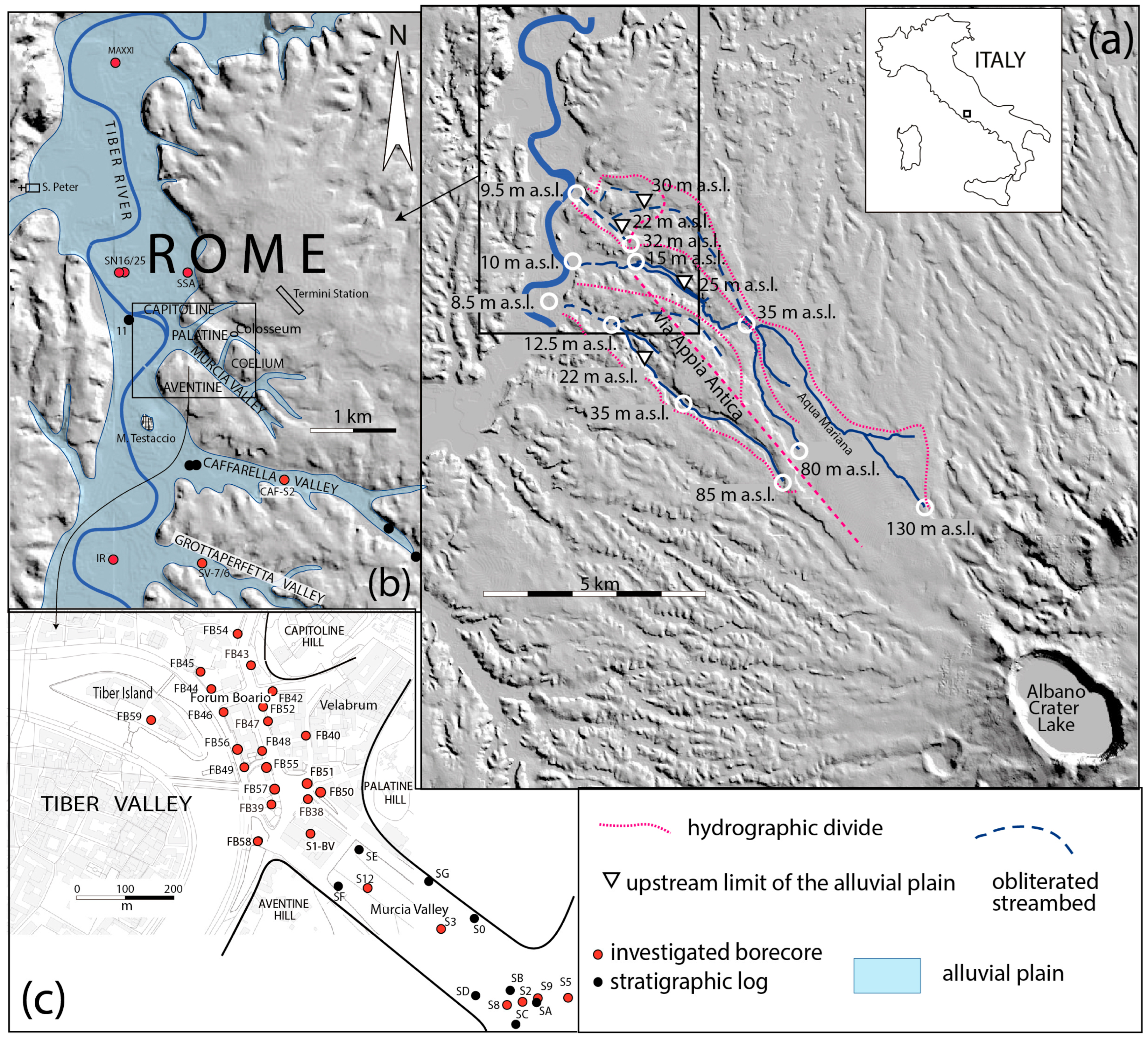
Figure 1. (a) DEM image (Tinitaly, property of INGV) showing the catchment basins of the investigated tributary valleys of the Tiber River; (b,c) enlargements showing location of the boreholes used for the stratigraphic study.
Quaternary 08 00059 g001
Figure 2. Stratigraphic log and photographs of the alluvial succession recovered between 5 and 15 m depth. Position and age of the samples for 14C dating is shown (in italics: unreliable ages on organic sediment). See text for comments and explanation.
Quaternary 08 00059 g002
Figure 3. (a) Isobath map of the bottom of the alluvial succession (blue lines; m a.s.l.) in the Murcia Valley and transversal cross-sections showing the stratigraphic setting; (b) Longitudinal profile through the Murcia Valley showing the 14C age constraints to the alluvial succession. See text for comments and explanations.
Quaternary 08 00059 g003
Figure 4. Isobath map of the bottom of the alluvial succession (blue lines; m a.s.l.) in the Caffarella Valley and longitudinal profile showing the age constraints provided by 14C dating performed on the sedimentary succession recovered in the CAF-S2 borehole. Red dots are locations of the boreholes employed for the reconstruction.
Quaternary 08 00059 g004
Figure 5. (a) Isobath map of the bottom of the alluvial succession (blue lines; m a.s.l.) in the Caffarella Valley; red dots are locations of the boreholes employed for the reconstruction. (b) Longitudinal profile showing the age constraints provided by 14C dating performed on the sedimentary succession.
Quaternary 08 00059 g005
Figure 6. Composite cross-section showing the 14C age constrain and the stratigraphic features of the alluvial successions of the Tiber River and the investigated tributary valleys in Rome, with emphasis on the occurrence of gravel horizons. For borehole location see Figure 1b,c.
Quaternary 08 00059 g006
Figure 7. 14C age vs. depth model for sediment aggradation in the Caffarella Valley (CAF), Forum Boarium (FB), Murcia Valley (VM), Grottaperfetta Valley (SV7/6), and Tiber River in Valco San Paolo (IR). The black/grey line reproduces the predicted sea level for central Italy, as from data in [8]. See text for comments and explanation.
Quaternary 08 00059 g007
Figure 8. (a) Alluvial plain of the Tiber River in Rome showing the position of the buried river channel affected by re-incision and gravel deposition in the interval 5200–4000 yr BP (grey rectangle: drawn from data by [13]); red dots are locations of the boreholes employed for the reconstruction; (b) Reconstruction of the erosional and depositional phases along a longitudinal profile in the Caffarella Valley (yellow track in inset a). See text for comments and explanation.
Quaternary 08 00059 g008
Table 1. 14C dates.
Table 1. 14C dates.
SampleMaterialConventional Radiocarbon AgeCalibrated
Age (yr BP)
Adopted Age
S2-7.50wood2440 ± 30 BP(62.3%) 2540–2357
(22.3%) 2700–2633
(9.7%) 2617–2583
(1.1%) 2571–2562
2498 ± 92
S2-10.25/30organic sediment3760 ± 30 BP(64.8%) 4188–4076
(15.5%) 4236–4195
(15.2%) 4041–3990
4113 ± 123 *
S2-11.75seeds3510 ± 30 BP(95.4%) 3872–36943833 ± 80
S2-15.30/35plant material4470 ± 30 BP(50.6%) 5289–5155
(35.5%) 5148–5025
(9.3%) 5014–4975
5272 ± 67
S2-19.70/75organic sediment7590 ± 30 BP(95.4%) 8423–83508386.5 ± 36.5 *
S2-23.52wood7780 ± 30 BP(93.6%) 8604–8453
(1.8%) 8632–8621
8528.5 ± 75.5
S2-28.65/67organic sediment12,920 ± 40 BP(95.4%) 15,604–15,28515,495 ± 160 *
* Results on organic sediment are considered unreliable ones and not used to assess the aggradational history.
Disclaimer/Publisher’s Note: The statements, opinions and data contained in all publications are solely those of the individual author(s) and contributor(s) and not of MDPI and/or the editor(s). MDPI and/or the editor(s) disclaim responsibility for any injury to people or property resulting from any ideas, methods, instructions or products referred to in the content.