Abstract
Roman fish tanks are found in various coastal regions of the Mediterranean, although the vast majority is found on the Tyrrhenian coast of Italy. In this work, a database was developed with information on 62 fish tanks along the Mediterranean coasts to document and compare their features and characteristics. The analysis of the developed database from the Mediterranean fish tanks has shown that, among the 62 fish tanks, ~56% were cut into the rock, indicating that this type of construction was the most popular at that time and probably had advantages over the others. Fish tanks as sea level indicators can provide accurate data on the sea level 2000 years ago. Well-preserved installations with prominent architectural features have a crucial role in determining the paleo sea level. The architectural elements that are mostly used in fish tanks for paleo sea level reconstructions are the crepido, cataractae and channels. Besides the scientific importance of the fish tanks as sea level markers, they also have great cultural and historical significance. Fish tanks can be promoted as heritage monuments and scholarly models to strengthen awareness about climate change, sea level rise and its consequences.
1. Introduction
Roman fish tanks are found in various coastal territories of the Mediterranean, but the vast majority is located in Italy [1]. Fish tanks are mainly located in the Tyrrhenian coast (54 in total, according to Giacopini et al. [2]), and only one is documented in the Adriatic [3]. More than twenty fishponds have been recorded in the rest of the Mediterranean, including Egypt [4,5], Greece [6,7,8,9], Croatia [10,11,12], Spain [13,14], France [15], and Israel [16,17,18,19].
Fish tanks were constructed between the 1st century BC and the 1st century AD for the farming of fish and their subsequent distribution to the market. This activity also provides information about the socioeconomic status of the areas of distribution and consumption and the people residing within those areas. Higginbotham [1] notes that the geomorphological traits, the proximity to water sources and some aesthetic parameters helped evaluate where fish tanks should be constructed. Any existing elements such as cavities and coves acted as natural barriers allowing the fish to be restrained within a specific territory. Another aspect influencing their location was sufficient access to salt and fresh water to ensure adequate water circulation and salt concentration. Fish tanks were either fully or partially constructed [1].
The presence of fish tanks along the present-day coasts allows us to understand the coastal evolution of the host area and the relative sea level changes. The characteristics of their design and construction allow us to determine the sea level during Roman times [20].
In 1972, Schmiedt [21] presented his major work on the examination of archaeological indicators of sea level change in the north-western Mediterranean. Since then, fish tanks have been extensively used to document relative sea level variations since Roman times [11,15,19,20,22]. Methods and principles for the investigation of fish tanks and their relation to the sea level have been developed by various researchers [15,18,20,22,23,24]. A crucial parameter for their use as an accurate sea level indicator is the proper interpretation of the position of the fish tank structural elements in relation to the sea level during their use [11,20,24,25].
Methodology
The applied methodology for this paper involved a comprehensive literature review on fish tanks in the Mediterranean. In addition to the use of online libraries such as ScienceDirect and Google Scholar, the review also included relevant books, such as “Piscinae Artificial Fishponds in Roman Italy” written by James Higginbotham in 1997 [1]. The search was conducted by using keywords such as “Roman fish tanks”, “Roman fish tanks in the Mediterranean”, “Roman fish tanks and sea level change”, “fish ponds” and “fish tanks and sea level indicators”. The applied criteria were articles that focused on the history and archaeology of fish tanks in the Mediterranean, and articles that used scientific data to analyze the role of fish tanks in the region. The time period for the search spanned from the earliest known evidence of fish tanks in the Mediterranean to the present day.
2. Overview of Fish Tanks Characteristics
Fish farming used to be an occupation of the rich [1] and symbolized wealth and luxury [2]. Originally, the first fish tanks were built inland near lakes or streams and provided a secure place for freshwater fish. Later, around the 1st century BC, a trend towards the consumption of sea water fish led to the development of seaside fishponds [1]. This consumption preference revealed social status differences, according to which the poor were content with freshwater fish while saltwater fish were destined to become the cuisine of high society.
2.1. Architecture of Roman Fish Tanks, Technical Aspects and Sea Hydraulics
Fish tanks were either cut on shore platforms or were partly or wholly built (Figure 1). Their structure is closely related to the morphological characteristics of the coast. The Latin author Columella, in the 1st century A.D., distinguishes three types of fish tanks, the depths of which vary [26]: (a) those cut on a rocky platform, with their depth at about 9 feet (2.745 m) below sea level, which often consisted of a few built walls and included flow channels beginning at the outer limit of the platform, with a depth of 2 feet (0.61 m) near the tank; (b) those completely built on the shore, with their depth at 7 feet (2.135 m); and (c) those only 2 feet deep (0.61 m), similar to the previous one, designed for flat fish. The construction of artificial enclosures on rocky surfaces or on surficial rock exposures extending towards the sea was a common design characteristic of coastal fish tanks. Coastal geomorphology and lithology were often exploited. The selection of a rocky topography was influenced by the presence of natural cavities and bays that provided enclosures for the confinement of fish.
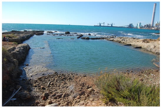
Figure 1.
La Mattonara fish tank, located on the Tyrrhenian coast of Italy, is an example cut on a shore platform.
The construction of fish tanks was greatly determined by the need for access to both sea water and fresh water in sufficient quantity to ensure the circulation of water and suitable salinity. Frequently, brackish conditions had to be met inside the enclosures to ensure the proper environmental conditions for the fish. Several Latin authors, such as Columella and Varro [26,27], mention the usefulness of mixing fresh water with sea water to attract fish into the tank or to decrease the salinity in summertime.
Salt water from the sea was mixed with fresh water in sufficient quantities to reach the required salinity. The site selection for seaside fishponds was determined by the distance to inland water sources. Fresh water could be transferred to the ponds via pipes driven by the force of gravity. The supply of freshwater into the pond was directly related to the difference in altitude between the pond and the water source and controlled the rate of water flow inside the pond (Figure 2). However, the sea currents in the ponds were not controlled in the same way as the freshwater. Sea water hydraulics used the natural forces of the waves and coastal currents to allow the continuous circulation of sea water into the basins of the ponds [1].
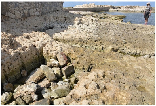
Figure 2.
Channel that enabled the transportation of fresh water into the Montazah fish tank of Alexandria, Egypt.
Coastal lagoons, rocky bays or natural coves provided ideal enclosures for the isolation of the pond and the conservation of the desired water mixture and temperature. Sea water hydraulics were also an important factor for the supply and distribution of the water inside the ponds. The fish tanks located on the coast took advantage of the natural sea forces for water circulation within the enclosures. The fish tanks that were supplied with sea water were always near the sea [1]. Sea water was moved by the tidal and wave force, and for this reason, it did not circulate far from its source. According to Columella [26], fish tanks of sea water should have been designed in such a way that incoming waves would move the water without allowing stagnant water to remain within the enclosure. A fish tank is similar to the open sea, where the turbulent water is circulated continuously by the winds and cannot be warmed as the waves disturb the cold water from the bottom to the top. Fresh water can be channeled to locations distant from its source, through aqueducts and water pipes. Gravity flow can maintain a hydraulic freshwater system of many kilometers long. The elevation difference between the fresh water source and the fish tank is in direct proportion to the pressure and flow rate of input water, thus providing a strong flow sufficient for circulation needs [1]. This technology enabled fish tanks to be constructed in a wide range of locations [1]. Beyond the architectural elements, standard scales relative to the sea level were used for the construction of the parts of the pond. For example, when constructing a fish tank, the sea level must have been seven Roman feet (2.06 m) above the bottom part of the pond [1].
Two main types of seaside fish tanks are recorded by Columella: those which were excavated in rock and those constructed in concrete. Fishponds entirely carved in the rock are scarce, as their construction was predominantly dependent upon the geomorphology of the coastal area. The second type of fishpond was built with the hydraulic concrete opus caementicium, a material excellent for underwater construction; concrete was beneficial in architectural design and allowed better space management for the owner’s fish tank. Most fish tanks were either entirely built or consisted of concrete-made parts mainly due to the operational, constructional and aesthetic benefits of doing so. Protective moles or thick perimetric walls were constructed by placing wet mortar and aggregates between temporary wooden forms or shuttering. This construction method guaranteed the protection of an area where a fish tank could be built, defending the tank from waves. Arching walls had an ornamented, decorative appearance, and this type of architecture gave the impression of elevated luxury (Figure 3).
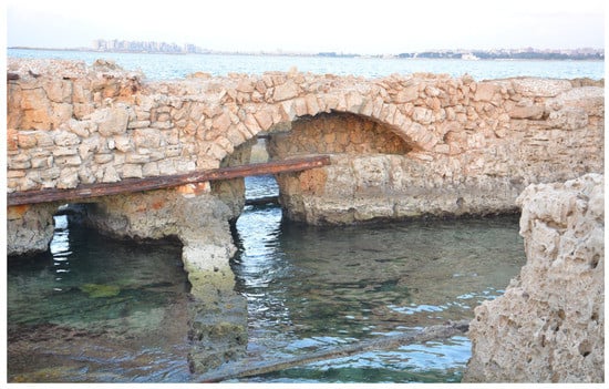
Figure 3.
Arching wall at the Montazah fish tank of Alexandria, Egypt, along with the channels that distributed water within the tank, ensuring its adequate circulation within the construction.
One of the main characteristics of the fish tanks was an outer protection breakwater (dock) constructed all around the basins that exceeded the basin depths [26]. Channels connected the tank with the open sea to ensure water renewal. Channel direction ranged according to the individual morphological and dynamic coastal characteristics of the area, trying to take advantage of wave power in order to let fresh sea water pass into the fishpond. Smaller channels (cuniculi) transferred water further into the fish tank and facilitated regular circulation [13].
The basins were delimited by walls over which foot-walks (crepidini) remained emerged. In some cases (e.g., Piscina di Lucullo, Formia, Astura, Punta della Vipera), lower levels of foot-walks have been found that were used for maintenance, oyster culture, etc. Several basins were connected through submerged arched openings (Piscina di Lucullo, La Banca, Punta della Vipera), or through metal fixed gates (cataractae) with holes, permitting the passage of water but not of fish (Ventotene), and depressions were cut at the top of the walls (Piscina di Lucullo, Fosso Guardiole, La Mattonara). Sluice gates along the channels or between the basins were operated along sliding grooves cut into stones. A representative example is the Piscina di Lucullo [2,28]. Such features can offer important information on past sea levels [20].
Columella states that fish tanks, either excavated from the rocky shore or constructed with hydraulic concrete, should be designed with channels that would allow the sea water to penetrate inside the enclosures [26]. Columella suggests that channels were positioned on every side of the fish tank, low on the wall of the enclosure so that the water forced through these openings would originate from the cooler depths of the sea.
All openings into the fish tank were to be covered with gates to prevent the fish from escaping. Columella refers to the use of bronze gate pierced by small holes (cataracta), which would prevent the fish from escaping while not interfering in circulation [26].
Fish tanks, in many cases, were architectural attempts at formalizing and controlling natural fishing grounds. The earliest attempts at organized fish-raising probably began at spots where fish were known to congregate. Sheltered zones where freshwater reached the sea would have been ideal sites to catch fish or to confine them until they were to be consumed. For instance, the harbor and fishery at Cosa (Spain) were constructed to be able to exploit a naturally brackish lagoon [29]. Fish suitable for the waters of the lagoon had to pass through the narrows of a rock-cut channel that followed a natural fissure in the promontory. There they could be trapped and held until being harvested or directed into tanks positioned in the lagoon.
The architecture of the Roman fish tanks ensured two basic needs: (a) that fish would not escape, and (b) the regulation of the water circulation in the enclosure. Among inland ponds, circular and semicircular plans were common and are reminiscent of the forms used in many seaside fish tanks. The phi-shaped fish tank at Grottarossa near Rome, with its central island, compares favorably with coastal enclosures [1].
While Columella recommended a depth of seven feet (2.14 m) for the fish tank basin, the remains of fish tanks indicate a range of less than one meter to over three meters [26]. Many fish tanks were divided into smaller tanks, allowing the owner to segregate his fish by species or age. Species of fish such as conger and murena could not coexist peacefully, and Columella appealed to isolate eels in separate ponds from other species of fish. Vertical slots would have secured movable grates (cancelli) [1]. These barriers could slide up and down to allow fish to pass through the connecting channel or opening.
The walls that enclosed fish tanks were principally designed to prevent the fish from escaping. Certain species of fish such as the grey mullet (Mugil) required higher walls due to their ability to jump. Many fast-swimming types of fish would jump when agitated or when confined in crowded conditions. Some walls unearthed during the excavation of the lagoonal fishery at Cosa exhibit substantial differences in height, which, according to the investigators, may indicate that the enclosures were built for different species of fish [30]. The precise heights of fish tank walls relative to the ancient sea level are difficult to determine and they vary depending on the tidal range.
Other design features that may have prevented fish from escaping are the platforms or steps within the interior of the pond. These platforms principally functioned as walkways for those who maintained the fish tank. Either cut in rock or constructed from concrete, these walkways are found on the walls of many fish tanks [31]. They were designed to always be above the water level or to be slightly awash so that movement, by those using and servicing the ponds, would be unhindered. In addition, these structures would prevent fish from reaching sufficient depth near the wall to be able to accelerate and escape from the enclosure. The internal divisions of these fish tanks could take on shapes that were pleasant to the eye, as well as being functional. Each could be viewed from attached platforms or from their associated villas. Moreover, the curvilinear design could withstand the force of waves using less construction materials than a straight wall.
The archaeological evidence shows that most fish tanks were constructed on land or along the shorefront, near Roman villas. The location of these residences was often chosen to exploit a panoramic view or to take advantage of the natural coves and inlets along the shore. The fish tank, with its perimeter moles enclosing large areas of seascape, reflects the desire to control nature and to include plants, animals and fish within the confines of the villa property. On a smaller scale, some fish tanks were equipped with small platforms that projected toward the middle of the enclosures. From these platforms visitors could enjoy the view from a slightly better point of vantage [1]. While providing similar protection to the fish, these features also served to mimic the larger and more prestigious seaside fish tank. Many coastal fish tanks were built in conjunction with dining facilities [32]. The connection between ponds and dining areas is not solely aesthetic but also has a gastronomic component. Fish or eels fresh from the fish tank would make an impressive addition to a private meal among friends and honored guests.
It should be noted that not all fish tanks were constructed with the same specifications. The architectural style changed with each location, and the construction elements had to be adjusted to the local morphological conditions of the area. In addition, the fishponds found far from the Tyrrhenian coast present significant differences in the design and operational use of each element of the pond [33]. Therefore, the structural characteristics of a specific fishpond must be carefully studied when used as sea level indicators.
2.2. Architectural Elements Used as Sea Level Indicators
2.2.1. Protective Docks
Similar to harbor design, docks were laid out to protect an area within which a fish tank could be constructed (Figure 4). The function of the perimeter docks was to protect the ponds from the action of the sea and to create calm conditions for breeding fish [34]. Docks may provide information on the relative sea level at the time of construction. According to Columella, one of the main characteristics of fish tanks is an outer protective breakwater constructed all around the basins, and higher than the m.s.l. at that time [21,26]: ‘Mox praeiaciuntur in gyrum moles, ita ut complectantur sinu suo et tamen excedant stagni modum’ [In addition docks are constructed all around in order to surround the basins and exceed their level]).
Figure 4.
Punta della Vipera fish tank, where the breaking of waves is visible in the outer breakwater.
2.2.2. Foot-Walks (Crepidine)
Foot-walks were narrow paths either cut in the rock or constructed with concrete along the inner tanks of many fish tanks (Figure 5a,b) [1]. These features were used by those using and servicing the ponds, and therefore, their original position would have been above sea level [1,13,20]. Evelpidou et al. [20] propose that the former mean sea level (m.s.l.) in a fish tank should be 35 cm below the top of the best-preserved upper crepidine (upper foot-walk). However, such an estimation has the drawback of lowering the ancient m.s.l. when the upper crepido is eroded [20]. In some cases, lower levels of foot-walks (lower crepidine) are found, which were used for maintenance, etc. (Figure 5b). Often, this morphological characteristic is very close to the bottom of the tank, and thus, it is impossible that it remained above water, because in this case, the depth of the water in the basin would have been insufficient for the fish to survive. It is obvious that this feature cannot be used as a sea level indicator but indicates only a limit.
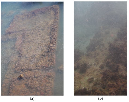
Figure 5.
(a) Foot-walks at Formia fish tank, Italy. (b) The lower crepidines at the fish tank La Grottacce, Italy.
2.2.3. Sluice Gates (Cataractae)
Cataractae were fixed gates with holes that permitted the passage of water but not fish (Figure 6) [20]. Morhange et al. [15] report that in situ mid-tidal closing gates (cataractae), which are precise indicators of relative sea level change, are exceptionally rare, due to their original location in the wave-breaking zone. The cataractae could be solid, to stop incoming water, or a net or sluice with small holes to allow water to enter, while preventing larger fish from escaping. Cataractae existed in the upper part of the fish tank, at the levels of the tidal range [20]. Sluice gates along the channels or between the basins operated along sliding grooves cut into stones; their marks may be particularly useful, if interpreted well, to estimate the past sea level.
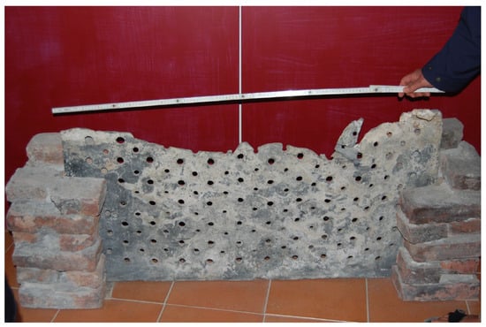
Figure 6.
Sluice gate (cataracta) from the Grottacce fish tank, Italy, presently at the Santa Marinella Museum.
2.2.4. Channels
Channels connected the tank with the open sea to ensure water renewal (Figure 7). Channel direction depends on the individual morphological and hydrodynamic coastal characteristics of the area, as their purpose is to take advantage of wave power in order to renew the water in a fishpond. Columella has suggested that channels were positioned on every side of the fish tank, low on the wall of the enclosure, so that the water forced through these openings would originate from the cooler depths of the sea. Some of the channels are separated vertically by a bar. Smaller channels would distribute the water and further ensure adequate circulation between the smaller basins inside the fish tank. Some channels were used for bringing fresh water from the inland to the fish tank. These channels were used by some kinds of fish during their seasonal migrations, and they were perfect spots to catch fish. The outer part of the fish tank, towards the open sea, would have been blocked by gates in order to stop the fish migration towards the open sea.
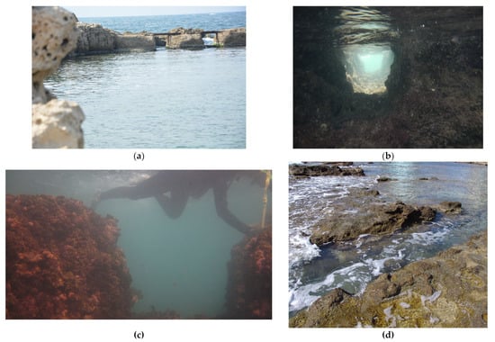
Figure 7.
(a) Channels at the Montazah fish tank, Alexandria, Egypt, that enabled water renewal in the fish tank. (b) Inner channel that connected two tanks at the fish tank of Montazah, Alexandria, Egypt. (c) Channel at the Odescalchi fish tank, Italy. (d) Channel at the Torre Valdaliga fish tank, Italy.
Channels open to the sea supplied water at least during the high tide cycle [35]. According to Schmiedt [21], the top of the channels would have remained above water during the highest tides. In fact, he assumes that the top of the channels would have been 40 cm above former m.s.l. to allow the fish tank keepers to reach the entrance of the outer channels.
Estimates of the lower limits of the past sea level are based on the assumption that at least 10 cm of high tide water must have passed over the bottom of the supplying channel at the basin entrance in order to maintain viable conditions inside the tank [15,20,36,37,38].
3. Distribution of Fish Tanks in the Mediterranean
A database with information about 62 fish tanks from the Mediterranean Sea was developed to document and compare their features and characteristics (Figure 8) (Table S1). Available bibliographic sources were used for the collection of information regarding published fish tanks, which were afterwards incorporated in the database.
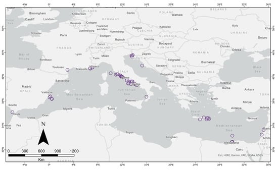
Figure 8.
Fish tank distribution across the Mediterranean Sea.
3.1. Fish Tanks of Spain
The fish tanks along the coasts of Spain are located at (a) Cape Trafalgar, Cadiz; (b) La Albufereta, Alicante; (c) Illeta dels Banyets in El Campello, Alicante; (d) Banos de la Reina in Calp, Alicante; and (e) Banos de la Reina in Xabia, Alicante [13]. They are found along the western Mediterranean coast, except from the one at Cape Trafalgar, which is located on the Atlantic coast of Spain, near Gibraltar [13]. These fish tanks are all completely carved into calcitic rock or sandstone to a depth of 2.7 m or less, depending on the type of the cultivated fish [23], and they are in good conservation condition, merely submerged or on land. Considering the level of preservation and the observed structural elements, the fish tanks of Spain that can be used as sea level indicators are those found along the Mediterranean coast [13].
3.2. Fish Tanks of France
In France, the fish tanks are found along the southern coast and they are located in (a) Port-la-Nautique, Narbonne, Aude; (b) La Gaillarde, Roquebrune-sur-Argens, Var; (c) Frejus, Var; (d) Ile Sainte-Marguerite, Cannes, Alpes-Maritimes; and (e) Antibes, Alpes-Maritimes [13]. They are cut into the coastal rock or reinforced with hydraulic concrete, partially submerged or found on land. Cataractae or channels are found with a good state of preservation.
The fish tank at Frejus, Var, located in southeastern Provence, was studied by Morhange et al. [15]. In the middle of the 1st century AD, the fish tank was entirely filled with silt and its operation stopped. Previous measurements and data were also obtained by Laborel et al. [39] and Devillers et al. [40]. In order to calculate the relative sea level during the Roman period, Morhange et al. [15] studied the zonation of fossil marine organisms attached to the fish tank walls. Combining evidence from architectural structures and biological sea level indicators, the relative sea level was estimated at 40 ± 10 cm below the present one [15]. Based on their measurements, Morhange et al. [15] further suggest that the use of fish tank channels is imprecise and tends to overestimate RSL rise. Sea level estimates by Morhange et al. [15] agree with Evelpidou et al. [20], who proposed a Roman sea level ranging from −32 ± 5 to −58 ± 5 cm (in respect to the present sea level) for the Tyrrhenian coast of Italy.
3.3. Fish Tanks along the Tyrrhenian Coast of Italy
During the Roman period, pisciculture and the techniques of fish cultivation were thriving in Italy. Large enclosures bordering the sea or small fishponds were built near coastal villas, adding luxury to the landscape architecture.
The number of fish tanks recorded along the Tyrrhenian coast of Italy is fifty-four (54) according to Giacopini et al. [2], and only one is recorded on the Adriatic coast [33]. A study by Evelpidou et al. [20] provided sea level measurements from eight fish tanks along the Tyrrhenian coast (Figure 9). All these fish tanks were found to be submerged and carried archaeological evidence of past sea levels. Structural elements such as sluice gates, cataractae, crepidines and overflow carvings were used as sea level indicators by Evelpidou et al. [20], who concluded that the sea level did not exceed −58 ± 5 cm during Roman times in respect to the present sea level.
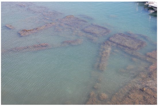
Figure 9.
The Formia fish tank, Italy, in which the rhombic shape was particularly used.
On the other hand, the study of Lambeck et al. [23] on the fish tanks of the Tyrrhenian coast concluded on a sea level of −1.3 m during the Roman period in respect to the present sea level. Using structural elements such as sluice gates, channels and foot walks in a complete state of preservation, Lambeck et al. [23] considered the top of the sluice gate to match with the height of the lower crepido and estimated that this lower crepido was 20 cm above the highest tide level. A suggestion was also that the water flow inside the tank was controlled by the tide.
Another study from Auriemma and Solinas [11] in the fish tanks of the Tyrrhenian coast provided paleo sea level measurements based on indicative markers of crepidines, canals, cataractae and carvings. Aucelli et al. [41] provided data on sea level change at the Sorento Peninsula from archaeological markers including fishponds. At the Sorento fishpond, they estimated a sea level rise of 1.1 ± 0.3 m from the Roman period. This sea level rise fits well with the theoretical model of Lambeck et al. [23].
Evelpidou et al. [20] used a different interpretation of the fish tank characteristics for the paleo sea level measurements. The proposition was that the lower crepido was found at the infratidal zone and the mean sea level was found between the lower and the higher crepido levels. They also suggested that the upper part of the sliding grooves (cataractae) ended at the upper foot-walk (crepido) and not the lower one. In the same study, it is also proposed that the height of cataractae, according to the interpretation of Lambeck et al. [23], is not enough for the proper functioning of the fish tank. An agreed interpretation of the hydraulic position of the fish tanks has not yet been established, and therefore, the need for an interdisciplinary approach for the reconstruction of the sea level is useful [25].
In the Gulf of Naples, in the Sorrento area, Aucelli et al. [22] estimated a sea level rise of 1.1 ± 0.30 m in the past 2000 years, based on the location of the upper crepido in the fish tank.
3.4. Adriatic Sea Fish Tanks
Five fish tanks have been recorded along the Adriatic coast: in Slovenia (S. Bartolomeo and Fisine) and Croatia (Katoro, Kupanja and Svrsata in Kornati Island). They were constructed with the technique of placing single stones (single rocks jetty), with pebbles and cobbles without the presence of mortar [11]. They consisted of multiple interior basins that were used for the division of different fish populations or fish of different ages [10]. Their construction dates to the 1st century A.D. In the Adriatic fish tanks, the water did not enter the fishpond via channels such as those on the Tyrrhenian coast but circulated from the sea into the tank through the permeable jetty. The jetty had structural elements such as blocks scattered or aligned for maintenance purposes.
Even though the fish tanks along the Adriatic coast lack architectural elements related to the sea level [11], there are two specific examples of accurate sea level markers at S. Bartholome and Fisine. Florido et al. [10] proposed a paleo sea level of ~−1.60 ± 0.20 m in respect to present sea level, regarding the Adriatic Sea. The authors further compared their findings with glacio-hydro-isostatic modelling and calculated tectonic subsidence rates ranging between 0.63 and 0.89 mm/year since Roman times.
3.5. Fish Tanks of Greece
Fish tanks have been reported in Greece as relics from the Roman Empire period. They are found in Crete on several coasts such as Ferma (Ierapetra area), Chersonissos, Matala, Siteia, Mochlos and the Gulf of Zakros [7,8,9,42]. Roman fishponds and fish traps in Crete were built close to the boisterous urban centers of that period [7]. Crete’s central geographic position in the eastern Mediterranean has an economic advantage, as shipments from all the major commercial centers passed from Crete to deliver merchandise. There is a direct connection between sea level and coastal morphology and harbors, cities and other installations along the island’s coasts. Any change in sea level or coastal morphology was associated with the socio-economic development of the coastal settlements [7]. Studies of fish tanks resulted in an estimation of the sea level at eastern Crete of 1.24 m ± 0.09 m below the present one during the Roman period [7]. Sea level estimates were based on depth measurements of the architectural and functional features of the fish tanks (e.g., fish tanks floor, depth of channels) in combination with other coastal landforms, such as beachrocks.
3.6. Fish Tanks of Israel
Archaeological studies along the coast of Israel have revealed ancient coastal installations such as harbors and quarries. Several rock-carved pools with ambiguous function heights exist, but offer no reliable means of dating [43,44]. Some of these are located at Shiqmona-Haifa, Habonim, Dor, Yonim Island, Caesarea and Tel Baruch. In Caesarea lies a rectangular pool cut inside the rock with channels that supply the enclosure with sea water, and it has been interpreted as a fishpond [45]. In general, most of the coastal structures are close to the present-day sea level. The absence of underwater structures suggests that either coastal erosion has destroyed them, or indicates, in a more compelling case, that the morphology of the Israeli coast has been tectonically stable since Roman times [45]. Dean et al. [19] defined the functional height for a fishpond at Akziv in Israel [17] which suggests an almost stable sea level since its function. Sea level index points for this estimation were based on the elevation/depth of the base of intake gate, which was assumed to be below mean tidal level to ensure water flux, or the top of walkways.
3.7. Fish Tanks of Egypt
Fish tanks and marine installations along the coast of Egypt have been reported from geoarchaeological studies (e.g., [4,5]). Fish tanks at Abou Kir peninsula, Alexandria, were first mapped by Bartocci [46] and were noted by Breccia [47]. Several fish tank installations have been noted in the coastal zone of Alexandria [5]. Three fish tanks from the Roman period have been studied in detail for paleo sea level reconstructions [5]. These are the fish tanks of Abou Kir (Figure 10), Miami island (Figure 11) and Montazah (Figure 12). They are cut into the rock and show a good state of preservation, except for the one in Abou Kir promontory, which is filled with sediments. At least four more fish tanks are evident in satellite images of the littoral area about 3 km from the east end of the Maamourah Bay towards Abou Kir promontory [5]. However, these structures are enclosed in military installations and even superficial observation of them is presently impossible.
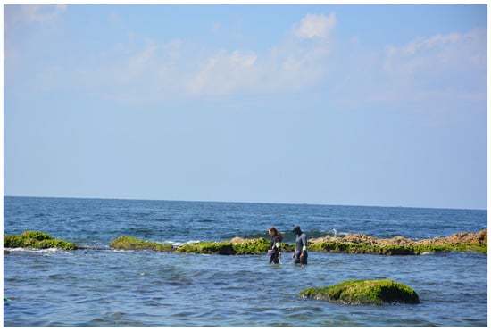
Figure 10.
The fish tanks of Abou Kir, in Alexandria, Egypt.
Figure 11.
The Miami Island fish tank in Alexandria, Egypt, is a complex and sophisticated construction, carved in the southeastern region of the homonymous island.
Figure 12.
The western part of the Montazah fish tank in Alexandria, Egypt.
In the Montazah fish tanks, located in the bay of Maamourah, the internal walls are constructed in a more delicate manner so visitors could walk around the perimeter of the installation and admire the view. This approach in construction style was probably inspired by the Tyrrhenian fish tanks such as the one in Torre Astura (Italy) [5].
Structural elements such as crepidines, cataractae and channels were identified and used as sea level indicators in combination with predictions from two Glacial Isostatic Adjustment (GIA) models [5]: ICE-6G (VM5a) [48] and ANU [49]. Sea level variations driven by glacioisostatic adjustment were modelled using an improved version of the Sea Level Equation solver SELEN [50]. For the past 3000 years, ICE-6G (VM5a) showed a stable RSL, while the ANU model revealed a very slight sea level high stand of ~15 cm at ~2000 years BP, followed by a slow sea level fall. Overall, the model calculations indicated that the GIA effects on RSL variations were limited during the time frame considered and have contributed little to sea level rise of 70 cm observed over the last 2000 years [5]. According to Evelpidou et al. [5], the sea level in Alexandria 2000 years ago was at 70 cm ± 5 cm below the present one.
3.8. Fish Tanks of Lebanon
Two Roman fish tanks were discovered in 2017 by Goiran et al. [51] in the coastal region of western Tyre, Lebanon. The first fish tank is located in the north and the second in the southern part of Tyre. Both are crafted into coastal sandstone inside pre-existing quarries. They have a mixed structural style with both rock-cut and constructed features. The northern fish tank has a sub-rectangular shape and maintains architectural elements such as a U-shaped channel that connects the tank with the open sea and surrounding foot-walks (crepidine) [51]. The southern fish tank has a rectangular shape and holds an elongated U-shaped channel that connects the tank with the sea. Observations from the position of the channels and the ledges of the fish tanks relative to the current tidal range and the present day biological mean sea level led to the conclusion that the sea has risen by 0.6 m since the time of their construction [51]. In particular, Goiran et al. [51] assume that when the fish tanks were functional, high tide should not have overflown the fish tank ledges. They further state that the tidal range is 60 cm and suggest that the biological sea level must have been located at −0.60 m compared to the present level when the fish tanks were functioning.
4. Fish Tanks as Sea Level Indicators
The previous paragraphs demonstrate the most important characteristics of fish tanks recorded in the Mediterranean region. It is noteworthy that most fish tanks adhere to a standard constructional layout whose fundamental architectural elements are the crepido, cataractae and channels. It is further observed that as one moves away from the fish tanks of Italy, the construction techniques of the tanks vary to accommodate the local parameters determined by the geomorphology of the area and potentially relate to architectural styles devised by the local populations. Although most fish tanks are located on the Tyrrhenian coast of Italy, those found in the rest of the Mediterranean also provide information about their local history, pointing to increased commercial activity and developed urban centers.
Fish tanks as sea level indicators can provide accurate data on the sea level 2000 years ago. Well-preserved installations with prominent architectural features have a crucial role in determining the paleo sea level. The architectural elements that are most used in fish tanks for paleo sea level reconstructions are the crepido, cataractae and channels. However, a good understanding of the functioning of each fish tank must be developed in order to determine the exact position of the indicative structural elements present in relation to the sea level.
The study of fish tanks as sea level indicators must be considered within a wider framework which allows for a better understanding of the sea level during the late Holocene period. Data from sea level research studies conclude upon a paleo sea level of between −0.5 and −1.5 m during the Roman period compared to the present one [7,10,15,20,22,23] (Table 1). However, the tectonic history of the area should be taken into account as vertical tectonic movements may have contributed to the present-day altitude of the fish tanks since the time of their construction; such examples are the fish tanks of Crete (Greece), the Sorrento peninsula (Italy) and the Adriatic Sea. In France, sea level estimation comes from a tectonically stable area [15], suggesting an RSL rise of 0.4 ± 0.10 m since Roman times. Conversely, in Crete, the sea level has risen by 1.24 ± 0.09 over the same period, suggesting an average tectonic subsidence of ~0.65 mm/year [7]. Similarly, Florido et al. [10] report tectonic subsidence values between 0.63 and 0.89 mm/year since Roman times.

Table 1.
Summary table of sea level estimates based on fish tanks.
5. Overview of Construction and Architectural Characteristics
The analysis of the developed database from the Mediterranean fish tanks shows that, among the 62 fish tanks, 35 (~56%) were cut into the rock, indicating that this type of construction was the most popular at that time and probably had advantages over the others (Figure 13). Only 11 fish tanks were constructed with a combination of hydraulic concrete and rock cutting techniques. Three of them are found on the French coast; one on Pianosa Island, Italy, between Corse and Rome; one more in Italy in the Sperlonga area, along the Tyrrhenian coast; two in Slovenia; two in Egypt; and two in Lebanon. The small number of this type of construction may reflect its lack of operational efficiency or the high economic cost of its installation. Its spatial distribution allows neither any general supposition about the geographic locations in which they are placed nor any reason for construction. The remaining 16 fish tanks were constructed with hydraulic concrete, and they are found on the Tyrrhenian coast of Italy, with another one along the French coast. This type of construction had benefits both in terms of construction and operation; when the geomorphology of the site did not meet the requirements for the correct functioning of the fish tank, the design could be modified to take advantage of the sea dynamics and satisfy the need for both salt and freshwater inflow. Additionally, with this method, the architect of the fish tank could use his own designs and geometrical features, such as arches and curved walls. For instance, the fish tank of La Saracca, Nettuno, Roma, Italy, has a semi-circular shape and is separated by walls into concentric arches [13] that bear both technical and aesthetic value (i.e., avoiding sediment accumulation at the junctions of the installation). In addition, villa owners may have opted for concrete installations to add beauty with elaborate designs to the interior decoration of their villas near the coasts. On the other hand, concrete-made fish tanks are less resistant to erosion than those cut into the rock. Therefore, most of them are not in a good preservation state and most of them do not bear any notable architectural elements to study.
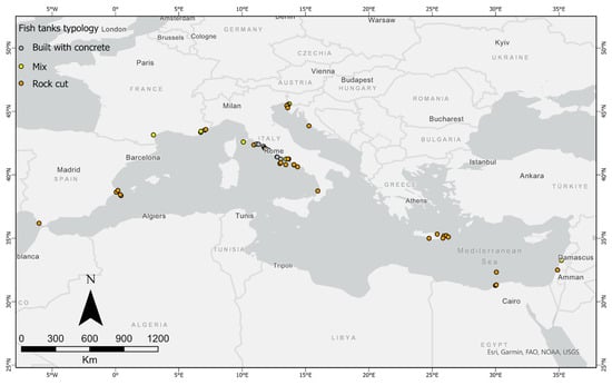
Figure 13.
Distribution of fish tanks along the Mediterranean based on their construction type.
The fish tanks along the Adriatic coast were all cut into the rock, and they did not follow the traditional building technique as those on the Tyrrhenian coast. Additionally, the large size of the fish tanks in the Adriatic Sea and Egypt lent them a commercial use for fish production and selling. These tanks were solely constructed for economic purposes, and they have a different social value than in the Villae Maritima context found along the Tyrrhenian coast [10].
Besides the scientific importance of the fish tanks as sea level markers, they also have cultural and historical significance. Fish tanks can be promoted as cultural heritage monuments to strengthen awareness about climate change, sea level rise and its consequences. Fish tanks have been an integral part of the Mediterranean region for over two thousand years, and they reflect the sophisticated engineering skills of ancient Romans and their approach to fish farming. These fish tanks serve as a link between the past and present, and preserving them is vital to help future generations understand and appreciate the historical and cultural value of these sites.
Promoting fish tanks as heritage monuments can raise awareness about climate change and sea level rise and their consequences. By educating the public about these issues, we can encourage people to take action in reducing the impact of climate change on our environment. Furthermore, fish tanks can serve as a model for sustainable fish farming, especially in areas with limited access to marine resources. Preserving and promoting fish tanks can also boost tourism in the region, providing economic benefits to local communities. Overall, preserving fish tanks as cultural heritage sites not only benefits scientific research but also helps to promote sustainable development and cultural tourism.
Supplementary Materials
The following supporting information can be downloaded at: https://www.mdpi.com/article/10.3390/quat6020024/s1, Table S1: Database of Mediterranean fish tanks.
Author Contributions
Conceptualization, N.E.; methodology, N.E., P.O. and A.K.; formal analysis, P.O. and A.K.; investigation, N.E., P.O. and A.K.; writing—original draft preparation, P.O., N.E., I.K., G.S. and A.K.; writing—review and editing, N.E., A.K., I.K. and G.S.; supervision, N.E.; All authors have read and agreed to the published version of the manuscript.
Funding
This research received no external funding.
Institutional Review Board Statement
Not applicable.
Informed Consent Statement
Not applicable.
Data Availability Statement
Data are contained within the article.
Acknowledgments
This work is dedicated to Paolo Pirazzoli.
Conflicts of Interest
The authors declare no conflict of interest.
References
- Higginbotham, J. Piscinae: Artificial Fishponds in Roman Italy; University of North Carolina Press: Chapel Hill, NC, USA, 1997. [Google Scholar]
- Giacopini, L.; Marchesini, B.; Rustico, L. L’Itticultura Nell’antichita; Enel: Rome, Italy, 1994. [Google Scholar]
- Lambeck, K.; Antonioli, F.; Purcell, A.; Silenzi, S. Sea-level change along the Italian coast for the past 10,000 yr. Quat. Sci. Rev. 2004, 23, 1567–1598. [Google Scholar] [CrossRef]
- Torab, M. Geomophological & geoarchaeological indicators of the Holocene sea-level changes on Ras El Hekma area, NW coast of Egypt. J. Afr. Earth Sci. 2016, 114, 85–95. [Google Scholar] [CrossRef]
- Evelpidou, N.; Repapis, C.; Zerefos, C.; Tzalas, H.; Synolakis, C. Geophysical Phenomena and the Alexandrian Littoral; Archaeopress: Oxford, UK, 2019; ISBN 9781789692358. [Google Scholar]
- Mourtzas, N.D. Archaeological indicators for sea level change and coastal neotectonic deformation: The submerged Roman fish tanks of the gulf of Matala, Crete, Greece. J. Archaeol. Sci. 2012, 39, 884–895. [Google Scholar] [CrossRef]
- Mourtzas, N.D. Fish tanks of eastern Crete (Greece) as indicators of the Roman sea level. J. Archaeol. Sci. 2012, 39, 2392–2408. [Google Scholar] [CrossRef]
- Davaras, C. A rock-cut fish tank near Hierapetra. Archaeol. Delt. 1975, 30A, 149–154. [Google Scholar]
- Davaras, C. Rock-cut fish tanks in Eastern Crete. Annu. Br. Sch. Athens 1974, 69, 87–93. [Google Scholar] [CrossRef]
- Florido, E.; Auriemma, R.; Faivre, S.; Radić Rossi, I.; Antonioli, F.; Furlani, S.; Spada, G. Istrian and Dalmatian fishtanks as sea-level markers. Quat. Int. 2011, 232, 105–113. [Google Scholar] [CrossRef]
- Auriemma, R.; Solinas, E. Archaeological remains as sea level change markers: A review. Quat. Int. 2009, 206, 134–146. [Google Scholar] [CrossRef]
- Carre, M.-B.; Katunarić, T. Le Vivier de Katoro (Istrie, Croatie). Chron. Act. Archéologiques L’école Française Rome 2012. [Google Scholar] [CrossRef]
- Caballero-Rubio, F.J.; Viñals, M.J.; Tormo-Esteve, S. The Roman fish tanks of the Western Mediterranean basin as potential scenarios for research on sea-level changes. J. Cult. Herit. Manag. Sustain. Dev. 2022, 12, 92–106. [Google Scholar] [CrossRef]
- Bernal-Casasola, D. Piscicultura y ostricultura en Baetica. Nuevos tiempos, nuevas costumbres. In Pescar con Arte. Fenicios y Romanos en el Origen de los Aparejos Andaluces; Bernal-Casasola, D., Ed.; Universidad de Cádiz: Cádiz, Spain, 2011; pp. 137–160. [Google Scholar]
- Morhange, C.; Marriner, N.; Excoffon, P.; Bonnet, S.; Flaux, C.; Zibrowius, H.; Goiran, J.-P.; Amouri, M. El Relative Sea-Level Changes During Roman Times in the Northwest Mediterranean: The 1st Century A.D. Fish Tank of Forum Julii, Fréjus, France. Geoarchaeology 2013, 28, 363–372. [Google Scholar] [CrossRef]
- Galili, E.; Salamon, A.; Gambash, G.; Zviely, D. Archaeological and natural indicators of sea-level and coastal changes: The case study of the caesarea roman harbor. Geosciences 2021, 11, 306. [Google Scholar] [CrossRef]
- Anzidei, M.; Antonioli, F.; Benini, A.; Lambeck, K.; Sivan, D.; Serpelloni, E.; Stocchi, P. Sea level change and vertical land movements since the last two millennia along the coasts of southwestern Turkey and Israel. Quat. Int. 2011, 232, 13–20. [Google Scholar] [CrossRef]
- Yasur-Landau, A.; Shtienberg, G.; Gambash, G.; Spada, G.; Melini, D.; Arkin-Shalev, E.; Tamberino, A.; Reese, J.; Levy, T.E.; Sivan, D. New relative sea-level (RSL) indications from the Eastern Mediterranean: Middle Bronze Age to the Roman period (~3800–1800 y BP) archaeological constructions at Dor, the Carmel coast, Israel. PLoS ONE 2021, 16, e0251870. [Google Scholar] [CrossRef]
- Dean, S.; Horton, B.P.; Evelpidou, N.; Cahill, N.; Spada, G.; Sivan, D. Can we detect centennial sea-level variations over the last three thousand years in Israeli archaeological records? Quat. Sci. Rev. 2019, 210, 125–135. [Google Scholar] [CrossRef]
- Evelpidou, N.; Pirazzoli, P.; Vassilopoulos, A.; Spada, G.; Ruggieri, G.; Tomasin, A. Late Holocene Sea Level Reconstructions Based on Observations of Roman Fish Tanks, Tyrrhenian Coast of Italy. Geoarchaeology 2012, 27, 259–277. [Google Scholar] [CrossRef]
- Schmiedt, G. Il Livello Antico del Mar Tirreno; E. Olschki: Florence, Italy, 1972. [Google Scholar]
- Aucelli, P.P.C.; Mattei, G.; Caporizzo, C.; Cinque, A.; Troisi, S.; Peluso, F.; Stefanile, M.; Pappone, G. Ancient Coastal Changes Due to Ground Movements and Human Interventions in the Roman Portus Julius (Pozzuoli Gulf, Italy): Results from Photogrammetric and Direct Surveys. Water 2020, 12, 658. [Google Scholar] [CrossRef]
- Lambeck, K.; Anzidei, M.; Antonioli, F.; Benini, A.; Esposito, A. Sea level in Roman time in the Central Mediterranean and implications for recent change. Earth Planet. Sci. Lett. 2004, 224, 563–575. [Google Scholar] [CrossRef]
- Vacchi, M.; Marriner, N.; Morhange, C.; Spada, G.; Fontana, A.; Rovere, A. Multiproxy assessment of Holocene relative sea-level changes in the western Mediterranean: Sea-level variability and improvements in the definition of the isostatic signal. Earth-Sci. Rev. 2016, 155, 172–197. [Google Scholar] [CrossRef]
- Benjamin, J.; Rovere, A.; Fontana, A.; Furlani, S.; Vacchi, M.; Inglis, R.H.; Galili, E.; Antonioli, F.; Sivan, D.; Miko, S.; et al. Late Quaternary sea-level changes and early human societies in the central and eastern Mediterranean Basin: An interdisciplinary review. Quat. Int. 2017, 449, 29–57. [Google Scholar] [CrossRef]
- Columella. De Re Rustica, XVII. In Il Livello Antico del Mar Tirreno. Testimonianze da Resti Archeologici; Schmiedt, G., Ed.; E. Olschki: Florence, Italy, 1972. [Google Scholar]
- Varro. De Re Rustica, III. In Il Livello Antico del Mar Tirreno. Testimonianze da Resti Archeologici; Schmiedt, G., Ed.; E. Olschki: Florence, Italy, 1972. [Google Scholar]
- Chiappella, V.G. Esplorazione della cosiddetta “Piscina di Lucullo” sul lago di Paola. Atti Della Accademia Nazionale Dei Lincei (CCCLXII). Not. Scavi Antich. 1965, 8, 146–160. [Google Scholar]
- McCann, A.M. The Roman Port and Fishery of Cosa: A Center of Ancient Trade; Princeton University Press: Princeton, NJ, USA, 1987. [Google Scholar]
- Gazda, E.K.; McCann, A.M. Chapter VII. Reconstruction and Function: Port, Fishery, and Villa. In The Roman Port and Fishery of Cosa; Princeton University Press: Princeton, NJ, USA, 2017; pp. 137–159. [Google Scholar]
- Del Rosso, R. Pesche e Peschiere Antiche e Moderne nell’Etruria Marittima; Osvaldo Paggi: Firenze, Italy, 1905. [Google Scholar]
- Ricotti, E.S.P. The importance of water in Roman Garden Triclinia. In Ancient Roman Villa Gardens; MacDougall, E.B., Ed.; Dumbarton Oaks: Washington, DC, USA, 1987; pp. 135–183. [Google Scholar]
- Lambeck, K.; Anzidei, M.; Antonioli, F.; Benini, A.; Verrubbi, V. Tyrrhenian sea level at 2000 BP: Evidence from Roman age fish tanks and their geological calibration. Rend. Lincei. Sci. Fis. Nat. 2018, 29, 69–80. [Google Scholar] [CrossRef]
- Martial. Epigrammaton libri X. Available online: https://www.tertullian.org/fathers/martial_epigrams_book10.htm (accessed on 1 January 2022).
- Pirazzoli, P.A. Sea-level changes and crustal movements in the Hellenic arc (Greece), the contribution of archaeological and historical data. In Archaeology of Coastal Changes, Proceedings of the First International Symposium “Cities on the Sea—Past and Present”, Haifa, Israel, 22–29 September 1986; Raban, A., Ed.; BAR International Series: Haifa, Israel, 1988; pp. 157–184. [Google Scholar]
- Caputo, M.; Pieri, L. Eustatic sea variation in the last 2000 years in the Mediterranean. J. Geophys. Res. 1976, 81, 5787–5790. [Google Scholar] [CrossRef]
- Flemming, N.C.; Webb, C.O. Tectonic and eustatic coastal changes during the last 10,000 years derived from archaeological data. Z. Geomorphol. Suppl. 1986, 62, 1–29. [Google Scholar]
- Leoni, G.; Dai Pra, G. Variazioni del Livello del Mare nel Tardo Olocene (Ultimi 2500 Anni) lungo la Costa del Lazio in Base ad Indicatori Geoarcheologici; ENEA: Rome, Italy, 1997. [Google Scholar]
- Laborel, J.; Morhange, C.; Lafont, R.; Le Campion, J.; Laborel-Deguen, F.; Sartoretto, S. Biological evidence of sea-level rise during the last 4500 years on the rocky coasts of continental southwestern France and Corsica. Mar. Geol. 1994, 120, 203–223. [Google Scholar] [CrossRef]
- Devillers, B.; Excoffon, P.; Morhange, C.; Bonnet, S.; Bertoncello, F. Relative sea-level changes and coastal evolution at Forum Julii (Fréjus, Provence). Comptes Rendus Geosci. 2007, 339, 329–336. [Google Scholar] [CrossRef]
- Aucelli, P.; Cinque, A.; Mattei, G.; Pappone, G. Historical sea level changes and effects on the coasts of Sorrento Peninsula (Gulf of Naples): New constrains from recent geoarchaeological investigations. Palaeogeogr. Palaeoclimatol. Palaeoecol. 2016, 463, 112–125. [Google Scholar] [CrossRef]
- Leatham, J.; Hood, S. Sub-marine exploration in Crete, 1955. Annu. Br. Sch. Athens 1959, 53, 263–280. [Google Scholar] [CrossRef]
- Stanley, D.J. Evaluating use of rock-hewn features for sea level measurement, Israeli Coast. J. Coast. Res. 1999, 15, 326–331. [Google Scholar]
- Dean, S. 3,000 Years of East Mediterranean Sea Levels: Archaeological Indicators from Greece Combined with Israeli Coast Data; University of Haifa Faculty: Haifa, Israel, 2015. [Google Scholar]
- Galili, E.; Sharvit, J. Ancient coastal installations and the tectonic stability of the Israeli coast in historical times. Geol. Soc. London Spec. Publ. 1999, 146, 147–163. [Google Scholar] [CrossRef]
- Bartocci, M. Penisola di Abukir. Piano generale con indicazioni (in rosso) delle rovine di Canopo e di Menuti. In Monuments de l’Égypte Gréco-Romaine, Vol I; Breccia, E., Ed.; Officine de l’Istituto Italiano d’Arte Grafiche: Bergamo, Italy, 1926. [Google Scholar]
- Breccia, E. Alexandrea Ad Aegyptum; Instituto Italiano d’Arti Grafiche: Bergamo, Italy, 1926. [Google Scholar]
- Peltier, W.R.; Argus, D.F.; Drummond, R. Space geodesy constrains ice age terminal deglaciation: The global ICE-6G_C (VM5a) model. J. Geophys. Res. Solid Earth 2015, 120, 450–487. [Google Scholar] [CrossRef]
- Lambeck, K.; Purcell, A.; Johnston, P.; Nakada, M.; Yokoyama, Y. Water-load definition in the glacio-hydro-isostatic sea-level equation. Quat. Sci. Rev. 2003, 22, 309–318. [Google Scholar] [CrossRef]
- Spada, G.; Stocchi, P. SELEN: A Fortran 90 program for solving the “sea-level equation. ” Comput. Geosci. 2007, 33, 538–562. [Google Scholar] [CrossRef]
- Goiran, J.-P.; Chapkanski, S.; Régagnon, E.; Pavlopoulos, K.; Fouache, E. Preliminary Results of Rock-cut Fish Tanks Evidence Along the Tyre Coast of Lebanon. Implication for Ancient Sea-level Reconstruction. BAAL 2019, 19, 259–266. [Google Scholar]
- Antonioli, F.; Anzidei, M.; Lambeck, K.; Auriemma, R.; Gaddi, D.; Furlani, S.; Orrù, P.; Solinas, E.; Gaspari, A.; Karinja, S.; et al. Sea-level change during the Holocene in Sardinia and in the northeastern Adriatic (central Mediterranean Sea) from archaeological and geomorphological data. Quat. Sci. Rev. 2007, 26, 2463–2486. [Google Scholar] [CrossRef]


Disclaimer/Publisher’s Note: The statements, opinions and data contained in all publications are solely those of the individual author(s) and contributor(s) and not of MDPI and/or the editor(s). MDPI and/or the editor(s) disclaim responsibility for any injury to people or property resulting from any ideas, methods, instructions or products referred to in the content. |
© 2023 by the authors. Licensee MDPI, Basel, Switzerland. This article is an open access article distributed under the terms and conditions of the Creative Commons Attribution (CC BY) license (https://creativecommons.org/licenses/by/4.0/).