
Early–Middle Pleistocene Magnetostratigraphic and Rock Magnetic Records of the Dolynske Section (Lower Danube, Ukraine) and Their Application to the Correlation of Loess–Palaeosol Sequences in Eastern and South-Eastern Europe


Abstract
:1. Introduction
2. Materials and Methods
2.1. Geological Setting

| Prymorske, after Veklich et al. [162] and Gozhik et al. [48] | Kurortne, after Vozgrin [237,238] and Shovkoplyas et al. [232] | Kurortne, after Tecsa et al. [233] | Kurortne (Model Presented Here) | ||||||
|---|---|---|---|---|---|---|---|---|---|
| Palaeosol | MIS | Palaeosol | MIS | Palaeosol | MIS | Palaeosol | Index | Unit | MIS |
| Prychornomorya | Vytachiv | 3 | Vytachiv | 3 | Vytachiv | vt | K-L1S1 | 3 | |
| Dofinivka 1 | Pryluky | 5a–c | Pryluky | 5a–c | Pryluky | pl | K-S1S1 | 5a–c | |
| Dofinivka 2 | 2 | Kaydaky | 5e | Kaydaky | 5e | Kaydaky | kd | K-S1S2 | 5e |
| Vytachiv | 3 | Potyagaylivka | 7 | Potyagaylivka | pt | K-S2 | 7 | ||
| Pryluky | 5 | Zavadivka | 9 | Upper Zavadivka | zv3c | K-S3S1 | 9a | ||
| Kaydaky | 7 | Lubny | 11 | zv3b | K-S3S2 + 3 | 9c–e | |||
| Zavadivka | 9–11 | Martonosha | ?–19 | Lower Zavadivka | zv1 | K-S4 | 11 | ||
| Lubny 1 | 13–15 | Lubny | lb | K-S5 | 13 | ||||
| Martonosha | 17–19 | Martonosha | mr | K-S6 | 15 | ||||
2.2. Sampling and Methods
3. Results
3.1. Pedostratigraphic Subdivision
3.2. Magnetic Susceptibility Values
3.3. Selected Mineral Magnetic Properties
3.4. Anisotropy of Magnetic Susceptibility
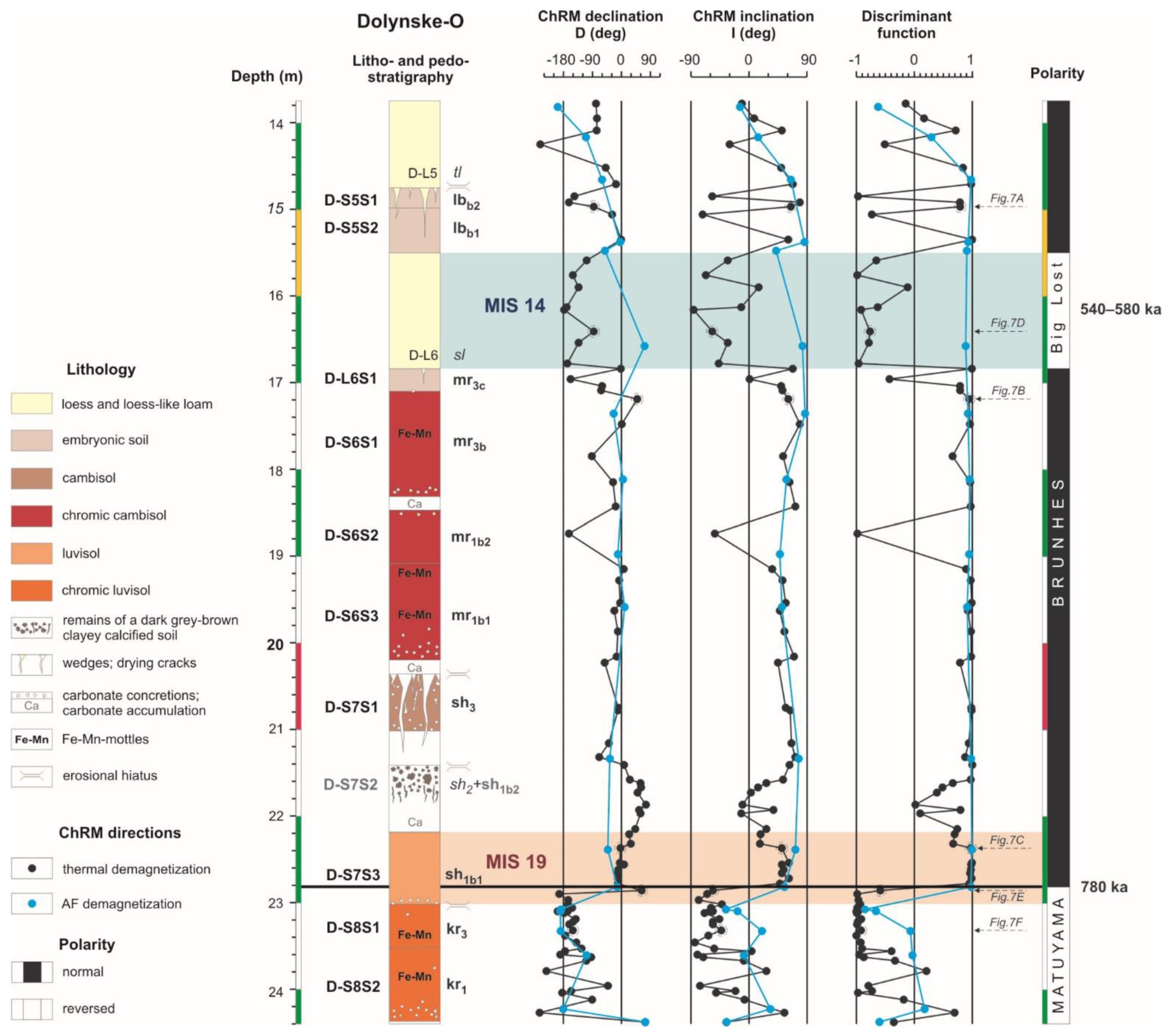
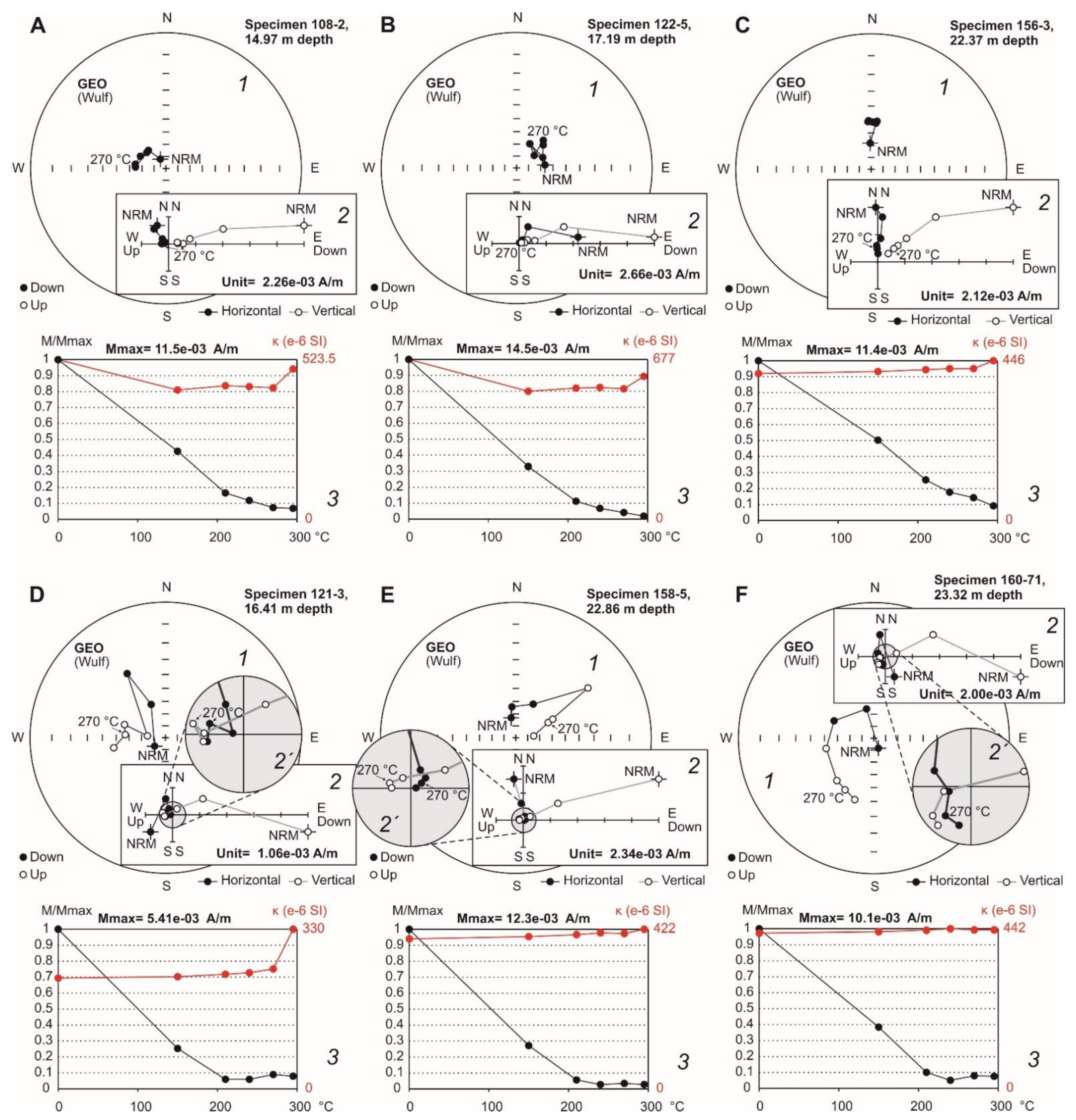
3.5. Magnetostratigraphy
3.6. Additional Palaeomagnetic Study of the Lowermost Part of the Kurortne Section
4. Discussion
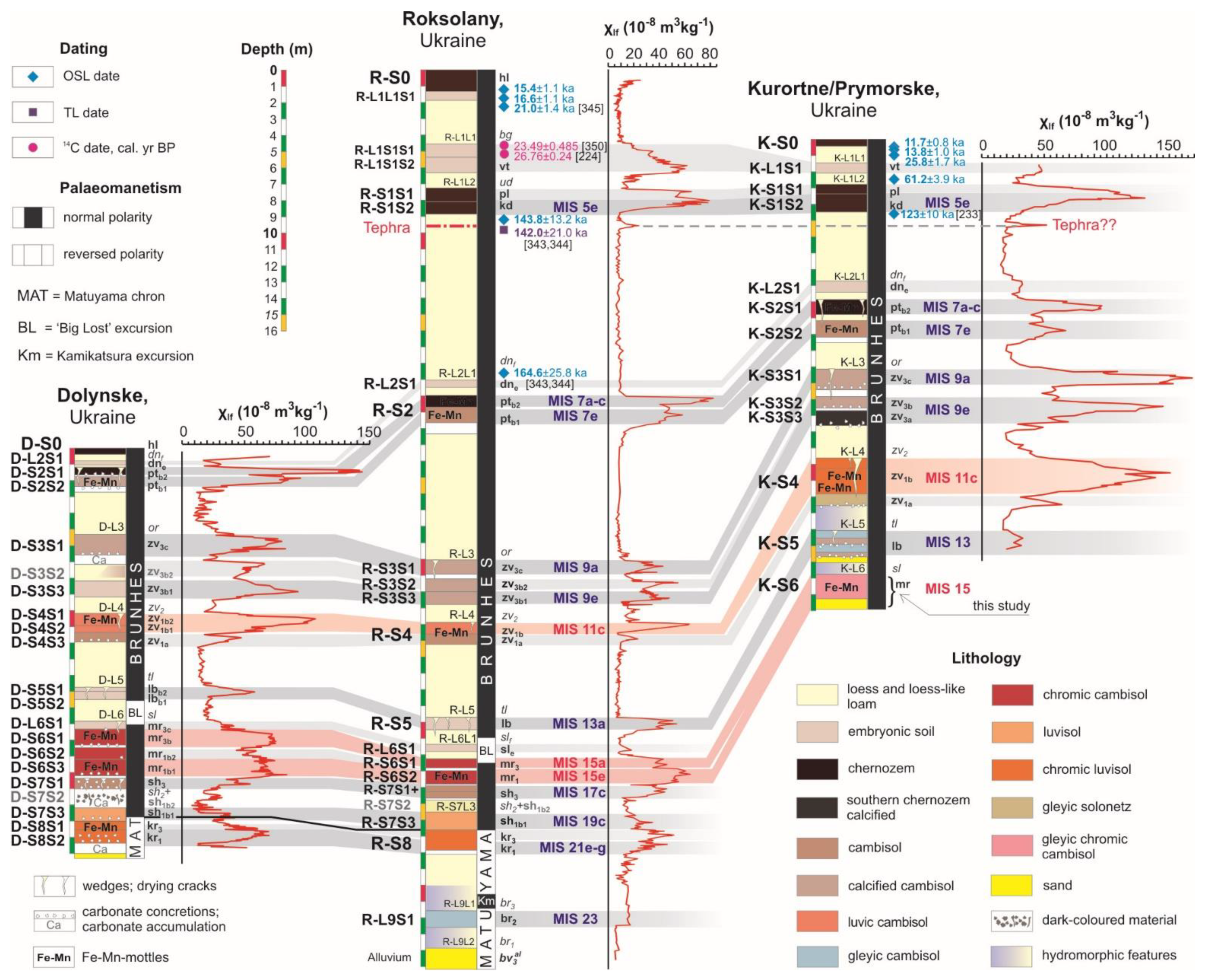
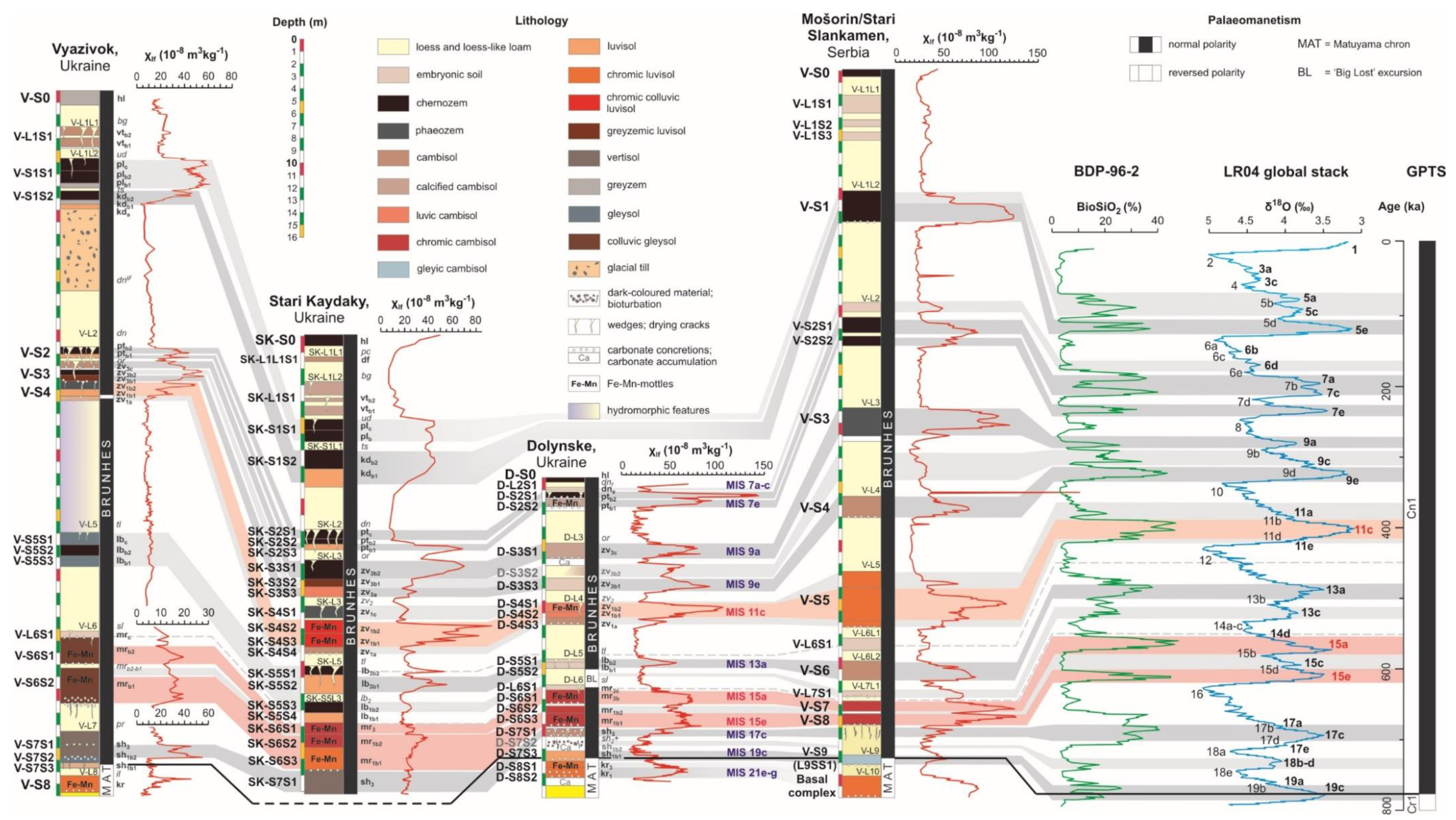
4.1. Magnetostratigraphy of Loess Sequences in the Western Black Sea Region
4.2. Land–Sea Correlations
4.2.1. Potyagaylivka Unit (MIS 7)
4.2.2. Zavadivka Superunit (MIS 9–11)
4.2.3. Lubny Unit (MIS 13)
4.2.4. Martonosha Unit (MIS 15)
4.2.5. Shyrokyne Superunit (MIS 17–19)
4.2.6. Correlation with the Romanian, Bulgarian and Serbian Loess Sequences
4.3. Promising Geochronometric Tools for Further Development of a Unified Ukrainian–Danube Loess Stratigraphic Model
5. Conclusions
Supplementary Materials
Author Contributions
Funding
Institutional Review Board Statement
Informed Consent Statement
Data Availability Statement
Acknowledgments
Conflicts of Interest
References
- Lowe, J.J.; Walker, M. Reconstructing Quaternary Environments, 3rd ed.; Routledge: London, UK, 2014; 538p. [Google Scholar] [CrossRef]
- Li, Y.; Shi, W.; Aydin, A.; Beroya-Eitner, M.A.; Gao, G. Loess Genesis and Worldwide Distribution. Earth-Sci. Rev. 2020, 201, 102947. [Google Scholar] [CrossRef]
- Pecsi, M. Loess stratigraphy and Quaternary climatic change. Loess inForm 1995, 3, 23–30. [Google Scholar]
- Haesaerts, P.; Damblon, F.; Gerasimenko, N.; Spagna, P.; Pirson, S. The Late Pleistocene Loess-Palaeosol Sequence of Middle Belgium. Quat. Int. 2016, 411, 25–43. [Google Scholar] [CrossRef]
- Antoine, P.; Coutard, S.; Bahain, J.-J.; Locht, J.-L.; Hérisson, D.; Goval, E. The Last 750 Ka in Loess–Palaeosol Sequences from Northern France: Environmental Background and Dating of the Western European Palaeolithic. J. Quat. Sci. 2021, in press. [Google Scholar] [CrossRef]
- Smalley, I.J.; Leach, J.A. The Origin and Distribution of the Loess in the Danube Basin and Associated Regions of East-Central Europe—A Review. Sediment. Geol. 1978, 21, 1–26. [Google Scholar] [CrossRef]
- Forster, T.; Heller, F.; Evans, M.E.; Havliček, P. Loess in the Czech Republic: Magnetic Properties and Paleoclimate. Stud. Geophys. Geod. 1996, 40, 243–261. [Google Scholar] [CrossRef]
- Jordanova, D.; Petersen, N. Palaeoclimatic Record from a Loess-Soil Profile in Northeastern Bulgaria—II. Correlation with Global Climatic Events during the Pleistocene. Geophys. J. Int. 1999, 138, 533–540. [Google Scholar] [CrossRef]
- Panaiotu, C.G.; Panaiotu, E.C.; Grama, A.; Necula, C. Paleoclimatic Record from a Loess-Paleosol Profile in Southeastern Romania. Phys. Chem. Earth Part A Solid Earth Geod. 2001, 26, 893–898. [Google Scholar] [CrossRef]
- Buggle, B.; Glaser, B.; Zöller, L.; Hambach, U.; Marković, S.; Glaser, I.; Gerasimenko, N. Geochemical Characterization and Origin of Southeastern and Eastern European Loesses (Serbia, Romania, Ukraine). Quat. Sci. Rev. 2008, 27, 1058–1075. [Google Scholar] [CrossRef]
- Buggle, B.; Hambach, U.; Glaser, B.; Gerasimenko, N.; Marković, S.; Glaser, I.; Zöller, L. Stratigraphy, and Spatial and Temporal Paleoclimatic Trends in Southeastern/Eastern European Loess–Paleosol Sequences. Quat. Int. 2009, 196, 86–106. [Google Scholar] [CrossRef]
- Kovács, J.; Fábián, S.Á.; Varga, G.; Újvári, G.; Varga, G.; Dezső, J. Plio-Pleistocene Red Clay Deposits in the Pannonian Basin: A Review. Quat. Int. 2011, 240, 35–43. [Google Scholar] [CrossRef]
- Marković, S.B.; Hambach, U.; Stevens, T.; Kukla, G.J.; Heller, F.; McCoy, W.D.; Oches, E.A.; Buggle, B.; Zöller, L. The Last Million Years Recorded at the Stari Slankamen (Northern Serbia) Loess-Palaeosol Sequence: Revised Chronostratigraphy and Long-Term Environmental Trends. Quat. Sci. Rev. 2011, 30, 1142–1154. [Google Scholar] [CrossRef]
- Marković, S.B.; Hambach, U.; Stevens, T.; Jovanović, M.; O’Hara-Dhand, K.; Basarin, B.; Lu, H.; Smalley, I.; Buggle, B.; Zech, M.; et al. Loess in the Vojvodina Region (Northern Serbia): An Essential Link between European and Asian Pleistocene Environments. Neth. J. Geosci. 2013, 91, 173–188. [Google Scholar] [CrossRef]
- Marković, S.B.; Stevens, T.; Kukla, G.J.; Hambach, U.; Fitzsimmons, K.E.; Gibbard, P.; Buggle, B.; Zech, M.; Guo, Z.; Hao, Q.; et al. Danube Loess Stratigraphy–Towards a Pan-European Loess Stratigraphic Model. Earth-Sci. Rev. 2015, 148, 228–258. [Google Scholar] [CrossRef] [Green Version]
- Marković, S.B.; Sümegi, P.; Stevens, T.; Schaetzl, R.J.; Obreht, I.; Chu, W.; Buggle, B.; Zech, M.; Zech, R.; Zeeden, C.; et al. The Crvenka Loess-Paleosol Sequence: A Record of Continuous Grassland Domination in the Southern Carpathian Basin during the Late Pleistocene. Palaeogeogr. Palaeoclim. Palaeoecol. 2018, 509, 33–46. [Google Scholar] [CrossRef]
- Varga, G. Similarities among the Plio–Pleistocene Terrestrial Aeolian Dust Deposits in the World and in Hungary. Quat. Int. 2011, 234, 98–108. [Google Scholar] [CrossRef]
- Fitzsimmons, K.E.; Marković, S.B.; Hambach, U. Pleistocene Environmental Dynamics Recorded in the Loess of the Middle and Lower Danube Basin. Quat. Sci. Rev. 2012, 41, 104–118. [Google Scholar] [CrossRef]
- Rădan, S.-C. Towards a Synopsis of Dating the Loess from the Romanian Plain and Dobrogea: Authors and Methods through Time. Geo-Eco-Marina 2012, 18, 153–172. [Google Scholar] [CrossRef]
- Újvári, G.; Varga, A.; Raucsik, B.; Kovács, J. The Paks Loess-Paleosol Sequence: A Record of Chemical Weathering and Provenance for the Last 800ka in the Mid-Carpathian Basin. Quat. Int. 2014, 319, 22–37. [Google Scholar] [CrossRef] [Green Version]
- Hošek, J.; Hambach, U.; Lisá, L.; Grygar, T.M.; Horáček, I.; Meszner, S.; Knésl, I. An Integrated Rock-Magnetic and Geochemical Approach to Loess/Paleosol Sequences from Bohemia and Moravia (Czech Republic): Implications for the Upper Pleistocene Paleoenvironment in Central Europe. Palaeogeogr. Palaeoclim. Palaeoecol. 2015, 418, 344–358. [Google Scholar] [CrossRef]
- Necula, C.; Dimofte, D.; Panaiotu, C. Rock Magnetism of a Loess-Palaeosol Sequence from the Western Black Sea Shore (Romania). Geophys. J. Int. 2015, 202, 1733–1748. [Google Scholar] [CrossRef] [Green Version]
- Terhorst, B.; Sedov, S.; Sprafke, T.; Peticzka, R.; Meyer-Heintze, S.; Kühn, P.; Solleiro Rebolledo, E. Austrian MIS 3/2 Loess–Palaeosol Records—Key Sites along a West–East Transect. Palaeogeogr. Palaeoclim. Palaeoecol. 2015, 418, 43–56. [Google Scholar] [CrossRef]
- Lehmkuhl, F.; Zens, J.; Krauß, L.; Schulte, P.; Kels, H. Loess-Paleosol Sequences at the Northern European Loess Belt in Germany: Distribution, Geomorphology and Stratigraphy. Quat. Sci. Rev. 2016, 153, 11–30. [Google Scholar] [CrossRef]
- Sauer, D.; Kadereit, A.; Kühn, P.; Kösel, M.; Miller, C.E.; Shinonaga, T.; Kreutzer, S.; Herrmann, L.; Fleck, W.; Starkovich, B.M.; et al. The Loess-Palaeosol Sequence of Datthausen, SW Germany: Characteristics, Chronology, and Implications for the Use of the Lohne Soil as a Marker Soil. Catena 2016, 146, 10–29. [Google Scholar] [CrossRef] [Green Version]
- Sümegi, P.; Náfrádi, K.; Molnár, D.; Sávai, S. Results of Paleoecological Studies in the Loess Region of Szeged-Öthalom (SE Hungary). Quat. Int. 2015, 372, 66–78. [Google Scholar] [CrossRef] [Green Version]
- Sümegi, P.; Marković, S.B.; Molnár, D.; Sávai, S.; Náfrádi, K.; Szelepcsényi, Z.; Novák, Z. Črvenka Loess-Paleosol Sequence Revisited: Local and Regional Quaternary Biogeographical Inferences of the Southern Carpathian Basin. Open Geosci. 2016, 8, 390–404. [Google Scholar] [CrossRef] [Green Version]
- Sümegi, P.; Gulyás, S.; Molnár, D.; Sümegi, B.P.; Almond, P.C.; Vandenberghe, J.; Zhou, L.; Pál-Molnár, E.; Törőcsik, T.; Hao, Q.; et al. New Chronology of the Best Developed Loess/Paleosol Sequence of Hungary Capturing the Past 1.1 Ma: Implications for Correlation and Proposed Pan-Eurasian Stratigraphic Schemes. Quat. Sci. Rev. 2018, 191, 144–166. [Google Scholar] [CrossRef]
- Sümegi, P.; Gulyás, S.; Molnár, D.; Sümegi, B.P.; Törőcsik, T.; Almond, P.C.; Smalley, I.; Zhou, L.; Galovic, L.; Pál-Molnár, E.; et al. Periodicities of Paleoclimate Variations in the First High-Resolution Non-Orbitally Tuned Grain Size Record of the Past 1 Ma from SW Hungary and Regional, Global Correlations. Aeolian Res. 2019, 40, 74–90. [Google Scholar] [CrossRef]
- Zeeden, C.; Kels, H.; Hambach, U.; Schulte, P.; Protze, J.; Eckmeier, E.; Marković, S.B.; Klasen, N.; Lehmkuhl, F. Three Climatic Cycles Recorded in a Loess-Palaeosol Sequence at Semlac (Romania)–Implications for Dust Accumulation in South-Eastern Europe. Quat. Sci. Rev. 2016, 154, 130–142. [Google Scholar] [CrossRef]
- Bösken, J.; Obreht, I.; Zeeden, C.; Klasen, N.; Hambach, U.; Sümegi, P.; Lehmkuhl, F. High-Resolution Paleoclimatic Proxy Data from the MIS3/2 Transition Recorded in Northeastern Hungarian Loess. Quat. Int. 2019, 502, 95–107. [Google Scholar] [CrossRef]
- Banak, A.; Mandic, O.; Pavelić, D.; Kovačić, M.; Lirer, F. Pleistocene Climate Change in Central Europe. In Pleistocene Archaeology–Migration, Technology, and Adaptation; Ono, R., Ed.; IntechOpen: London, UK, 2020. [Google Scholar]
- Flašarová, K.; Strouhalová, B.; Šefrna, L.; Verrecchia, E.; Lauer, T.; Juřičková, L.; Kolařík, P.; Ložek, V. Multiproxy Evidence of Middle and Late Pleistocene Environmental Changes in the Loess-Paleosol Sequence of Bůhzdař (Czech Republic). Quat. Int. 2020, 552, 4–14. [Google Scholar] [CrossRef]
- Novothny, Á.; Barta, G.; Végh, T.; Bradák, B.; Surányi, G.; Horváth, E. Correlation of Drilling Cores and the Paks Brickyard Key Section at the Area of Paks, Hungary. Quat. Int. 2020, 552, 50–61. [Google Scholar] [CrossRef]
- Sprafke, T.; Schulte, P.; Meyer-Heintze, S.; Händel, M.; Einwögerer, T.; Simon, U.; Peticzka, R.; Schäfer, C.; Lehmkuhl, F.; Terhorst, B. Paleoenvironments from Robust Loess Stratigraphy Using High-Resolution Color and Grain-Size Data of the Last Glacial Krems-Wachtberg Record (NE Austria). Quat. Sci. Rev. 2020, 248, 106602. [Google Scholar] [CrossRef]
- Wacha, L.; Laag, C.; Grizelj, A.; Tsukamoto, S.; Zeeden, C.; Ivanišević, D.; Rolf, C.; Banak, A.; Frechen, M. High-Resolution Palaeoenvironmental Reconstruction at Zmajevac (Croatia) over the Last Three Glacial/Interglacial Cycles. Palaeogeogr. Palaeoclim. Palaeoecol. 2021, 576, 110504. [Google Scholar] [CrossRef]
- Issmer, K. Vistulian Loess Deposits in Western Poland and Their Palaeoenvironmental Implications. Quat. Int. 2001, 76–77, 129–139. [Google Scholar] [CrossRef]
- Lindner, L.; Gozhik, P.; Marciniak, B.; Marks, L.; Yelovicheva, Y. Main climatic changes in the Quaternary of Poland, Belarus and Ukraine. Geol. Q. 2004, 48, 97–114. [Google Scholar]
- Lindner, L.; Bogutsky, A.; Gozhik, P.; Marks, L.; Łanczont, M.; Wojtanowicz, J. Correlation of Pleistocene deposits in the area between the Baltic and Black Sea, Central Europe. Geol. Q. 2006, 50, 195–210. [Google Scholar]
- Lindner, L.; Marks, L. Pleistocene Stratigraphy of Poland and Its Correlation with Stratotype Sections in the Volhynian Upland (Ukraine). Geochronometria 2008, 31, 31–37. [Google Scholar] [CrossRef] [Green Version]
- Badura, J.; Jary, Z.; Smalley, I. Sources of Loess Material for Deposits in Poland and Parts of Central Europe: The Lost Big River. Quat. Int. 2013, 296, 15–22. [Google Scholar] [CrossRef]
- Krawczyk, M.; Ryzner, K.; Skurzyński, J.; Jary, Z. Lithological Indicators of Loess Sedimentation of SW Poland. Contemp. Trends Geosci. 2017, 6, 94–111. [Google Scholar] [CrossRef]
- Chmielowska, D.; Woronko, B. A Source of Loess-like Deposits and Their Attendant Palaeoenvironment–Orava Basin, Western Carpathian Mountains, S Poland. Aeolian Res. 2019, 38, 60–76. [Google Scholar] [CrossRef]
- Marks, L.; Bińka, K.; Woronko, B.; Majecka, A.; Teodorski, A. Revision of the Late Middle Pleistocene Stratigraphy and Palaeoclimate in Poland. Quat. Int. 2019, 534, 5–17. [Google Scholar] [CrossRef]
- Dzierżek, J.; Lindner, L. Stratigraphy and conditions of accumulation of the Younger Loesses (Vistulian) in the Holy Cross Mountains area, Poland. Stud. Quat. 2020, 37, 109–120. [Google Scholar] [CrossRef]
- Dzierżek, J.; Lindner, L.; Nawrocki, J. The Loess Section in Wąchock as the Key Site of Vistulian Loesses and Palaeosols in the Holy Cross Mountains (Poland). Geol. Q. 2020, 64, 252–262. [Google Scholar] [CrossRef] [Green Version]
- Veklich, M.F. Stratigraphy of the Loess Formation of Ukraine and Adjacent Countries; Naukova Dumka: Kiev, Ukraine, 1968; 201p. (In Russian) [Google Scholar]
- Gozhik, P.; Shelkoplyas, V.; Khristoforova, T. Development stages of loessial and glacial formations in Ukraine (Stratigraphy of loesses in Ukraine). Ann. UMCS Sect. B 1995, 50, 65–74. [Google Scholar]
- Rousseau, D.-D.; Gerasimenko, N.; Matviischina, Z.; Kukla, G. Late Pleistocene Environments of the Central Ukraine. Quat. Res. 2001, 56, 349–356. [Google Scholar] [CrossRef] [Green Version]
- Rousseau, D.-D.; Antoine, P.; Gerasimenko, N.; Sima, A.; Fuchs, M.; Hatté, C.; Moine, O.; Zoeller, L. North Atlantic Abrupt Climatic Events of the Last Glacial Period Recorded in Ukrainian Loess Deposits. Clim. Past 2011, 7, 221–234. [Google Scholar] [CrossRef] [Green Version]
- Gerasimenko, N. Upper Pleistocene Loess–Palaeosol and Vegetational Successions in the Middle Dnieper Area, Ukraine. Quat. Int. 2006, 149, 55–66. [Google Scholar] [CrossRef]
- Gozhik, P.F.; Gerasimenko, N.P. The Lower and Middle Pleistocene of Ukraine. In Quaternary Studies in Ukraine, Proceedings of the XVIII Congress of the International Assosiation on the Study of the Quaternary period (INQUA), Bern, Switzerland, 21–27 July 2011; Gerasimenko, N.P., Gozhik, P.F., Dykan, N.I., Matviishyna, Z.M., Shelkoplyas, V.M., Vozgrin, B.D., Eds.; Institute of Geological Sciences NASU: Kyiv, Ukraine, 2011; pp. 9–26. [Google Scholar]
- Łanczont, M.; Bogucki, A.; Yatsyshyn, A.; Terpiłowski, S.; Mroczek, P.; Orłowska, A.; Hołub, B.; Zieliński, P.; Komar, M.; Woronko, B.; et al. Stratigraphy and Chronology of the Periphery of the Scandinavian Ice Sheet at the Foot of the Ukrainian Carpathians. Palaeogeogr. Palaeoclim. Palaeoecol. 2019, 530, 59–77. [Google Scholar] [CrossRef]
- Matviishyna, Z.M.; Doroshkevych, S.P. Micromorphological Peculiarities of the Pleistocene Soils in the Middle Pobuzhzhya (Ukraine) and Their Significance for Paleogeographic Reconstructions. J. Geol. Geogr. Geoecol. 2019, 28, 327–347. [Google Scholar] [CrossRef]
- Sirenko, O.A. Changes in Pleistocene Vegetation and Climate of Ukraine in the Range of 1.8–0.4 Million Years. J. Geol. Geogr. Geoecol. 2019, 28, 355–366. [Google Scholar] [CrossRef] [Green Version]
- Sirenko, O. Palaeoenvironmental Conditions of the Formation of Sediments of the Early Pliocene of Ukrainian Plain and the Vegetation Cover Dynamics. Geol. J. 2021, 56, 839–850. [Google Scholar] [CrossRef]
- Bonchkovskyi, O.S. Changes in Pedogenic Processes during Pryluky Times (Late Pleistocene) in the Central Part of the Volyn Upland. J. Geol. Geogr. Geoecol. 2019, 28, 230–240. [Google Scholar] [CrossRef]
- Bonchkovskyi, O. The Loess-Palaeosol Sequence of Novyi Tik: A New Middle and Upper Pleistocene Record for Volyn’ Upland (North-West Ukraine). Quaternaire 2020, 31, 281–308. [Google Scholar] [CrossRef]
- Marks, L.; Woronko, B.; Majecka, A.; Rylova, T.; Orłowska, A.; Hrachanik, M.; Rychel, J.; Zbucki, Ł.; Bahdasarau, M.; Hradunova, A.; et al. Middle Pleistocene Deposits at Rechitsa, Western Belarus, and Their Input to MIS 12-6 Stratigraphy in Central Europe. Quat. Int. 2020, 553, 34–52. [Google Scholar] [CrossRef]
- Velichko, A.A. Loess-paleosol formation on the Russian Plain. Quat. Int. 1990, 7–8, 103–114. [Google Scholar] [CrossRef]
- Matasova, G.; Petrovský, E.; Jordanova, N.; Zykina, V.; Kapička, A. Magnetic Study of Late Pleistocene Loess/Palaeosol Sections from Siberia: Palaeoenvironmental Implications. Geophys. J. Int. 2001, 147, 367–380. [Google Scholar] [CrossRef] [Green Version]
- Matasova, G.G.; Kazansky, A.Y.; Shchetnikov, A.A.; Erbajeva, M.A.; Filinov, I.A. New Rock- and Paleomagnetic Data on Quaternary Deposits of the Tologoi Key Section, Western Transbaikalia, and Their Paleoclimatic Implications. Izv. Phys. Solid Earth 2020, 56, 392–412. [Google Scholar] [CrossRef]
- Chlachula, J.; Evans, M.E.; Rutter, N.W. A Magnetic Investigation of a Late Quaternary Loess/Palaeosol Record in Siberia. Geophys. J. Int. 2002, 132, 128–132. [Google Scholar] [CrossRef] [Green Version]
- Bolikhovskaya, N.S.; Molodkov, A.N. East European Loess–Palaeosol Sequences: Palynology, Stratigraphy and Correlation. Quat. Int. 2006, 149, 24–36. [Google Scholar] [CrossRef]
- Konstantinov, E.A.; Velichko, A.A.; Kurbanov, R.N.; Zakharov, A.L. Middle to Late Pleistocene Topography Evolution of the North-Eastern Azov Region. Quat. Int. 2018, 465, 72–84. [Google Scholar] [CrossRef]
- Panin, P.G.; Timireva, S.N.; Morozova, T.D.; Kononov, Y.M.; Velichko, A.A. Morphology and Micromorphology of the Loess-Paleosol Sequences in the South of the East European Plain (MIS 1–MIS 17). Catena 2018, 168, 79–101. [Google Scholar] [CrossRef]
- Zastrozhnov, A.; Danukalova, G.; Shick, S.; van Kolfshoten, T. State of Stratigraphic Knowledge of Quaternary Deposits in European Russia: Unresolved Issues and Challenges for Further Research. Quat. Int. 2018, 478, 4–26. [Google Scholar] [CrossRef]
- Költringer, C.; Stevens, T.; Bradák, B.; Almqvist, B.; Kurbanov, R.; Snowball, I.; Yarovaya, S. Enviromagnetic Study of Late Quaternary Environmental Evolution in Lower Volga Loess Sequences, Russia. Quat. Res. 2020, 1–25. [Google Scholar] [CrossRef]
- Sycheva, S.; Frechen, M.; Terhorst, B.; Sedov, S.; Khokhlova, O. Pedostratigraphy and Chronology of the Late Pleistocene for the Extra Glacial Area in the Central Russian Upland (Reference Section Aleksandrov Quarry). Catena 2020, 194, 104689. [Google Scholar] [CrossRef]
- Zykina, V.S.; Zykin, V.S.; Volvakh, A.O.; Radaković, M.G.; Gavrilov, M.B.; Marković, S.B. Late Pleistocene Loess-Paleosol Sequence at the Belovo Section, South of Western Siberia, Russia: Preliminary Results. Quat. Int. 2020. [Google Scholar] [CrossRef]
- Wolf, D.; Baumgart, P.; Meszner, S.; Fülling, A.; Haubold, F.; Sahakyan, L.; Meliksetian, K.; Faust, D. Loess in Armenia–Stratigraphic Findings and Palaeoenvironmental Indications. Proc. Geol. Assoc. 2016, 127, 29–39. [Google Scholar] [CrossRef]
- Richter, C.; Wolf, D.; Walther, F.; Meng, S.; Sahakyan, L.; Hovakimyan, H.; Wolpert, T.; Fuchs, M.; Faust, D. New Insights into Southern Caucasian Glacial–Interglacial Climate Conditions Inferred from Quaternary Gastropod Fauna. J. Quat. Sci. 2020, 35, 634–649. [Google Scholar] [CrossRef]
- Mazneva, E.; Konstantinov, E.; Zakharov, A.; Sychev, N.; Tkach, N.; Kurbanov, R.; Sedaeva, K.; Murray, A. Middle and Late Pleistocene Loess of the Western Ciscaucasia: Stratigraphy, Lithology and Composition. Quat. Int. 2021, 590, 146–163. [Google Scholar] [CrossRef]
- Forster, T.; Heller, F. Loess Deposits from the Tajik Depression (Central Asia): Magnetic Properties and Paleoclimate. Earth Planet. Sci. Lett. 1994, 128, 501–512. [Google Scholar] [CrossRef]
- Ding, Z.L.; Ranov, V.; Yang, S.L.; Finaev, A.; Han, J.M.; Wang, G.A. The Loess Record in Southern Tajikistan and Correlation with Chinese Loess. Earth Planet. Sci. Lett. 2002, 200, 387–400. [Google Scholar] [CrossRef]
- Dodonov, A.E.; Sadchikova, T.A.; Sedov, S.N.; Simakova, A.N.; Zhou, L.P. Multidisciplinary Approach for Paleoenvironmental Reconstruction in Loess-Paleosol Studies of the Darai Kalon Section, Southern Tajikistan. Quat. Int. 2006, 152–153, 48–58. [Google Scholar] [CrossRef]
- Wang, X.; Wei, H.; Taheri, M.; Khormali, F.; Danukalova, G.; Chen, F. Early Pleistocene Climate in Western Arid Central Asia Inferred from Loess-Palaeosol Sequences. Sci. Rep. 2016, 6, 20560. [Google Scholar] [CrossRef] [Green Version]
- Jia, J.; Lu, H.; Wang, Y.; Xia, D. Variations in the Iron Mineralogy of a Loess Section in Tajikistan During the Mid-Pleistocene and Late Pleistocene: Implications for the Climatic Evolution in Central Asia. Geochem. Geophys. 2018, 19, 1244–1258. [Google Scholar] [CrossRef]
- Sprafke, T.; Fitzsimmons, K.E.; Grützner, C.; Elliot, A.; Marquer, L.; Nigmatova, S. Reevaluation of Late Pleistocene Loess Profiles at Remizovka (Kazakhstan) Indicates the Significance of Topography in Evaluating Terrestrial Paleoclimate Records. Quat. Res. 2018, 89, 674–690. [Google Scholar] [CrossRef]
- Vlaminck, S.; Kehl, M.; Rolf, C.; Franz, S.O.; Lauer, T.; Lehndorff, E.; Frechen, M.; Khormali, F. Late Pleistocene Dust Dynamics and Pedogenesis in Southern Eurasia–Detailed Insights from the Loess Profile Toshan (NE Iran). Quat. Sci. Rev. 2018, 180, 75–95. [Google Scholar] [CrossRef]
- Dar, R.A.; Zeeden, C. Loess-Palaeosol Sequences in the Kashmir Valley, NW Himalayas: A Review. Front. Earth Sci. 2020, 8, 113. [Google Scholar] [CrossRef] [Green Version]
- Li, Y.; Song, Y.; Fitzsimmons, K.E.; Chen, X.; Prud’homme, C.; Zong, X. Origin of Loess Deposits in the North Tian Shan Piedmont, Central Asia. Palaeogeogr. Palaeoclim. Palaeoecol. 2020, 559, 109972. [Google Scholar] [CrossRef]
- Zhang, J.; Zhou, X.; Long, H. Late Quaternary Loess Accumulation at the Rudak Section in Uzbekistan, Central Asia: Chronology and Palaeoclimate Implications. Palaeogeogr. Palaeoclim. Palaeoecol. 2020, 547, 109695. [Google Scholar] [CrossRef]
- Kehl, M.; Vlaminck, S.; Köhler, T.; Laag, C.; Rolf, C.; Tsukamoto, S.; Frechen, M.; Sumita, M.; Schmincke, H.-U.; Khormali, F. Pleistocene Dynamics of Dust Accumulation and Soil Formation in the Southern Caspian Lowlands–New Insights from the Loess-Paleosol Sequence at Neka-Abelou, Northern Iran. Quat. Sci. Rev. 2021, 253, 106774. [Google Scholar] [CrossRef]
- Heller, F.; Liu, T.-S. Magnetostratigraphical Dating of Loess Deposits in China. Nature 1982, 300, 431–433. [Google Scholar] [CrossRef]
- Heller, F.; Liu, T.-S. Magnetism of Chinese Loess Deposits. Geophys. J. Int. 1984, 77, 125–141. [Google Scholar] [CrossRef]
- Liu, T.-S. Loess and Environment; China Ocean Press: Beijing, China, 1985; pp. 31–67. [Google Scholar]
- Kukla, G.J. Loess stratigraphy in Central China. Quat. Sci. Rev. 1987, 6, 191–219. [Google Scholar] [CrossRef]
- Kukla, G.; Heller, F.; Ming, L.X.; Chun, X.T.; Sheng, L.T.; Sheng, A.Z. Pleistocene Climates in China Dated by Magnetic Susceptibility. Geology 1988, 16, 811–814. [Google Scholar] [CrossRef]
- Kukla, G.; An, Z. Loess Stratigraphy in Central China. Palaeogeogr. Palaeoclim. Palaeoecol. 1989, 72, 203–225. [Google Scholar] [CrossRef]
- Ding, Z.; Yu, Z.; Rutter, N.W.; Liu, T. Towards an Orbital Time Scale for Chinese Loess Deposits. Quat. Sci. Rev. 1994, 13, 39–70. [Google Scholar] [CrossRef]
- Ding, Z.L.; Derbyshire, E.; Yang, S.L.; Yu, Z.W.; Xiong, S.F.; Liu, T.S. Stacked 2.6-Ma Grain Size Record from the Chinese Loess Based on Five Sections and Correlation with the Deep-Sea δ18O Record. Paleoceanography 2002, 17, 5-1–5-21. [Google Scholar] [CrossRef]
- Evans, M.E.; Heller, F. Magnetic Enhancement and Palaeoclimate: Study of A Loess/Palaeosol Couplet Across the Loess Plateau of China. Geophys. J. Int. 1994, 117, 257–264. [Google Scholar] [CrossRef] [Green Version]
- Bloemendal, J.; Liu, X.M.; Rolph, T.C. Correlation of the Magnetic Susceptibility Stratigraphy of Chinese Loess and the Marine Oxygen Isotope Record: Chronological and Palaeoclimatic Implications. Earth Planet. Sci. Lett. 1995, 131, 371–380. [Google Scholar] [CrossRef]
- Vandenberghe, J.; Zhisheng, A.; Nugteren, G.; Huayu, L.; Huissteden, K.V. New Absolute Time Scale for the Quaternary Climate in the Chinese Loess Region by Grain-Size Analysis. Geology 1997, 25, 35–38. [Google Scholar] [CrossRef]
- Sun, D.; Shaw, J.; An, Z.; Cheng, M.; Yue, L. Magnetostratigraphy and Paleoclimatic Interpretation of a Continuous 7.2 Ma Late Cenozoic Eolian Sediments from the Chinese Loess Plateau. Geophys. Res. Lett. 1998, 25, 85–88. [Google Scholar] [CrossRef]
- Lu, H.; Liu, X.; Zhang, F.; An, Z.; Dodson, J. Astronomical Calibration of Loess-Paleosol Deposits at Luochuan, Central Chinese Loess Plateau. Palaeogeogr. Palaeoclim. Palaeoecol. 1999, 154, 237–246. [Google Scholar] [CrossRef]
- Heslop, D.; Langereis, C.G.; Dekkers, M.J. A New Astronomical Timescale for the Loess Deposits of Northern China. Earth Planet. Sci. Lett. 2000, 184, 125–139. [Google Scholar] [CrossRef]
- Nugteren, G.; Vandenberghe, J.; van Huissteden, J.K.; Zhisheng, A. A Quaternary Climate Record Based on Grain Size Analysis from the Luochuan Loess Section on the Central Loess Plateau, China. Glob. Planet. Chang. 2004, 41, 167–183. [Google Scholar] [CrossRef]
- Vandenberghe, J.; Nugteren, G. Rapid Climatic Changes Recorded in Loess Successions. Glob. Planet. Chang. 2001, 28, 1–9. [Google Scholar] [CrossRef]
- Bokhorst, M.P.; Beets, C.J.; Marković, S.B.; Gerasimenko, N.P.; Matviishina, Z.N.; Frechen, M. Pedo-Chemical Climate Proxies in Late Pleistocene Serbian–Ukranian Loess Sequences. Quat. Int. 2009, 198, 113–123. [Google Scholar] [CrossRef]
- Buggle, B.; Hambach, U.; Kehl, M.; Marković, S.B.; Zöller, L.; Glaser, B. The Progressive Evolution of a Continental Climate in Southeast-Central European Lowlands during the Middle Pleistocene Recorded in Loess Paleosol Sequences. Geology 2013, 41, 771–774. [Google Scholar] [CrossRef]
- Buggle, B.; Hambach, U.; Müller, K.; Zöller, L.; Marković, S.B.; Glaser, B. Iron Mineralogical Proxies and Quaternary Climate Change in SE-European Loess–Paleosol Sequences. Catena 2014, 117, 4–22. [Google Scholar] [CrossRef]
- Galović, L.; Peh, Z. Mineralogical Discrimination of the Pleistocene Loess/Paleosol Sections in Srijem and Baranja, Croatia. Aeolian Res. 2016, 21, 151–162. [Google Scholar] [CrossRef]
- Hošek, J.; Lisá, L.; Hambach, U.; Petr, L.; Vejrostová, L.; Bajer, A.; Grygar, T.M.; Moska, P.; Gottvald, Z.; Horsák, M. Middle Pleniglacial Pedogenesis on the Northwestern Edge of the Carpathian Basin: A Multidisciplinary Investigation of the Bíňa Pedo-Sedimentary Section, SW Slovakia. Palaeogeogr. Palaeoclim. Palaeoecol. 2017, 487, 321–339. [Google Scholar] [CrossRef]
- Bösken, J.; Sümegi, P.; Zeeden, C.; Klasen, N.; Gulyás, S.; Lehmkuhl, F. Investigating the Last Glacial Gravettian Site ‘Ságvár Lyukas Hill’ (Hungary) and Its Paleoenvironmental and Geochronological Context Using a Multi-Proxy Approach. Palaeogeogr. Palaeoclim. Palaeoecol. 2018, 509, 77–90. [Google Scholar] [CrossRef]
- Rousseau, D.-D.; Derbyshire, E.; Antoine, P.; Hatté, C. European Loess Records. In Reference Module in Earth Systems and Environmental Sciences; Elsevier: Amsterdam, The Netherlands, 2018. [Google Scholar]
- Schaetzl, R.J.; Bettis, E.A.; Crouvi, O.; Fitzsimmons, K.E.; Grimley, D.A.; Hambach, U.; Lehmkuhl, F.; Marković, S.B.; Mason, J.A.; Owczarek, P.; et al. Approaches and Challenges to the Study of Loess—Introduction to the LoessFest Special Issue. Quat. Res. 2018, 89, 563–618. [Google Scholar] [CrossRef] [Green Version]
- Wacha, L.; Rolf, C.; Hambach, U.; Frechen, M.; Galović, L.; Duchoslav, M. The Last Glacial Aeolian Record of the Island of Susak (Croatia) as Seen from a High-Resolution Grain–Size and Rock Magnetic Analysis. Quat. Int. 2018, 494, 211–224. [Google Scholar] [CrossRef]
- Zeeden, C.; Hambach, U.; Obreht, I.; Hao, Q.; Abels, H.A.; Veres, D.; Lehmkuhl, F.; Gavrilov, M.B.; Marković, S.B. Patterns and Timing of Loess-Paleosol Transitions in Eurasia: Constraints for Paleoclimate Studies. Glob. Planet. Chang. 2018, 162, 1–7. [Google Scholar] [CrossRef]
- Zhao, J.-B.; Ma, Y.-D.; Lui, R.; Luo, X.-Q.; Shao, T.-J. Palaeoclimatic and Hydrological Environments Inferred by Moisture Indexes from the S4 Palaeosol Section in the Xi’an Region, China. Quat. Int. 2018, 493, 127–136. [Google Scholar] [CrossRef]
- Molnár, D.; Makó, L.; Sümegi, P.; Sümegi, B.P.; Törőcsik, T. Revisiting the Palaeolithic site at Szeged-Öthalom: Attempt for appoint the Palaeolithic horizon. Stud. Quat. 2019, 36, 45–53. [Google Scholar] [CrossRef]
- Molnár, D.; Sümegi, P.; Fekete, I.; Makó, L.; Sümegi, B.P. Radiocarbon Dated Malacological Records of Two Late Pleistocene Loess-Paleosol Sequences from SW-Hungary: Paleoecological Inferences. Quat. Int. 2019, 504, 108–117. [Google Scholar] [CrossRef]
- Molnár, D.; Makó, L.; Cseh, P.; Sümegi, P.; Fekete, I.; Galović, L. Middle and Late Pleistocene loess-palaeosol archives in East Croatia: Multi-proxy palaeoecological studies on Zmajevac and Šarengrad II sequences. Stud. Quat. 2021, 38, 3–17. [Google Scholar] [CrossRef]
- Varga, G.; Újvári, G.; Kovács, J. Interpretation of Sedimentary (Sub)Populations Extracted from Grain Size Distributions of Central European Loess-Paleosol Series. Quat. Int. 2019, 502, 60–70. [Google Scholar] [CrossRef]
- Csonka, D.; Bradák, B.; Barta, G.; Szeberényi, J.; Novothny, Á.; Végh, T.; Süle, G.T.; Horváth, E. A Multi-Proxy Study on Polygenetic Middle-to Late Pleistocene Paleosols in the Hévízgyörk Loess-Paleosol Sequence (Hungary). Quat. Int. 2020, 552, 25–35. [Google Scholar] [CrossRef]
- Krauss, L.; Klasen, N.; Schulte, P.; Lehmkuhl, F. New Results Concerning the Pedo- and Chronostratigraphy of the Loess–Palaeosol Sequence Attenfeld (Bavaria, Germany) Derived from a Multi-Methodological Approach. J. Quat. Sci. 2021, in press. [Google Scholar] [CrossRef]
- Laag, C.; Hambach, U.; Zeeden, C.; Lagroix, F.; Guyodo, Y.; Veres, D.; Jovanović, M.; Marković, S.B. A Detailed Paleoclimate Proxy Record for the Middle Danube Basin Over the Last 430 Kyr: A Rock Magnetic and Colorimetric Study of the Zemun Loess-Paleosol Sequence. Front. Earth Sci. 2021, 9, 1–24. [Google Scholar] [CrossRef]
- Scheidt, S.; Berg, S.; Hambach, U.; Klasen, N.; Pötter, S.; Stolz, A.; Veres, D.; Zeeden, C.; Brill, D.; Brückner, H.; et al. Chronological Assessment of the Balta Alba Kurgan Loess-Paleosol Section (Romania)—A Comparative Study on Different Dating Methods for a Robust and Precise Age Model. Front. Earth Sci. 2021, 8, 1–23. [Google Scholar] [CrossRef]
- Meng, X.; Derbyshire, E.; Kemp, R.A. Origin of the Magnetic Susceptibility Signal in Chinese Loess. Quat. Sci. Rev. 1997, 16, 833–839. [Google Scholar] [CrossRef]
- Hambach, U.; Rolf, C.; Schnepp, E. Magnetic Dating of Quaternary Sediments, Volcanites and Archaeological Materials: An Overview. E&G Quat. Sci. J. 2008, 57, 25–51. [Google Scholar] [CrossRef]
- Cervi, E.C.; Maher, B.; Poliseli, P.C.; de Souza Junior, I.G.; da Costa, A.C.S. Magnetic Susceptibility as a Pedogenic Proxy for Grouping of Geochemical Transects in Landscapes. J. Appl. Geophys. 2019, 169, 109–117. [Google Scholar] [CrossRef]
- Nawrocki, J.; Wøjcik, A.; Bogucki, A. The Magnetic Susceptibility Record in the Polish and Western Ukrainian Loess-Palaeosol Sequences Conditioned by Palaeoclimate. Boreas 1996, 25, 161–169. [Google Scholar] [CrossRef]
- Maher, B.A. Magnetic Properties of Modern Soils and Quaternary Loessic Paleosols: Paleoclimatic Implications. Palaeogeogr. Palaeoclim. Palaeoecol. 1998, 137, 25–54. [Google Scholar] [CrossRef] [Green Version]
- Maher, B.A. The Magnetic Properties of Quaternary Aeolian Dusts and Sediments, and Their Palaeoclimatic Significance. Aeolian Res. 2011, 3, 87–144. [Google Scholar] [CrossRef]
- Maher, B.A. Palaeoclimatic Records of the Loess/Palaeosol Sequences of the Chinese Loess Plateau. Quat. Sci. Rev. 2016, 154, 23–84. [Google Scholar] [CrossRef]
- Evans, M.; Heller, F. Magnetism of loess/palaeosoil sequences: Recent development. Earth-Sci. Rev. 2001, 54, 129–144. [Google Scholar] [CrossRef]
- Evans, M.E.; Heller, F. Environmental Magnetism. Principles and Applications of Enviromagnetics; Academic Press: San Diego, CA, USA, 2003; pp. 9–29. [Google Scholar]
- Matasova, G.G.; Kazansky, A.Y. Magnetic properties and magnetic fabrics of Pleistocene loess/palaeosol deposits along west-central Siberian transect and their palaeoclimatic implications. Geol. Soc. Spec. Publ. 2004, 238, 145. [Google Scholar] [CrossRef]
- Jordanova, D.; Hus, J.; Geeraerts, R. Palaeoclimatic Implications of the Magnetic Record from Loess/Palaeosol Sequence Viatovo (NE Bulgaria). Geophys. J. Int. 2007, 171, 1036–1047. [Google Scholar] [CrossRef]
- Maxbauer, D.P.; Feinberg, J.M.; Fox, D.L. Magnetic Mineral Assemblages in Soils and Paleosols as the Basis for Paleoprecipitation Proxies: A Review of Magnetic Methods and Challenges. Earth-Sci. Rev. 2016, 155, 28–48. [Google Scholar] [CrossRef]
- Menshov, O.; Sukhorada, A. Basic theory and methodology of soil geophysics: The first results of application. Visnyk Taras Shevchenko Natl. Univ. Kyiv Geol. 2017, 79, 35–39. [Google Scholar] [CrossRef]
- Radaković, M.G.; Gavrilov, M.B.; Hambach, U.; Schaetzl, R.J.; Tošić, I.; Ninkov, J.; Vasin, J.; Marković, S.B. Quantitative Relationships between Climate and Magnetic Susceptibility of Soils on the Bačka Loess Plateau (Vojvodina, Serbia). Quat. Int. 2019, 502, 85–94. [Google Scholar] [CrossRef]
- Bradák, B.; Seto, Y.; Chadima, M.; Kovács, J.; Tanos, P.; Újvári, G.; Hyodo, M. Magnetic Fabric of Loess and Its Significance in Pleistocene Environment Reconstructions. Earth-Sci. Rev. 2020, 210, 103385. [Google Scholar] [CrossRef]
- Bradák, B.; Seto, Y.; Stevens, T.; Újvári, G.; Fehér, K.; Költringer, C. Magnetic Susceptibility in the European Loess Belt: New and Existing Models of Magnetic Enhancement in Loess. Palaeogeogr. Palaeoclim. Palaeoecol. 2021, 569, 110329. [Google Scholar] [CrossRef]
- Ghafarpour, A.; Khormali, F.; Balsam, W.; Forman, S.L.; Cheng, L.; Song, Y. The Formation of Iron Oxides and Magnetic Enhancement Mechanisms in Northern Iranian Loess-Paleosol Sequences: Evidence from Diffuse Reflectance Spectrophotometry and Temperature Dependence of Magnetic Susceptibility. Quat. Int. 2021, 589, 68–82. [Google Scholar] [CrossRef]
- Jordanova, D.; Jordanova, N. Updating the Significance and Paleoclimate Implications of Magnetic Susceptibility of Holocene Loessic Soils. Geoderma 2021, 391, 114982. [Google Scholar] [CrossRef]
- Költringer, C.; Bradák, B.; Stevens, T.; Almqvist, B.; Banak, A.; Lindner, M.; Kurbanov, R.; Snowball, I. Palaeoenvironmental Implications from Lower Volga Loess–Joint Magnetic Fabric and Multi-Proxy Analyses. Quat. Sci. Rev. 2021, 267, 107057. [Google Scholar] [CrossRef]
- Namier, N.; Gao, X.; Hao, Q.; Marković, S.B.; Fu, Y.; Song, Y.; Zhang, H.; Wu, X.; Deng, C.; Gavrilov, M.B.; et al. Mineral Magnetic Properties of Loess–Paleosol Couplets of Northern Serbia over the Last 1.0 Ma. Quat. Res. 2021, 103, 35–48. [Google Scholar] [CrossRef]
- Zeeden, C.; Hambach, U. Magnetic Susceptibility Properties of Loess from the Willendorf Archaeological Site: Implications for the Syn/Post-Depositional Interpretation of Magnetic Fabric. Front. Earth Sci. 2021, 8, 599491. [Google Scholar] [CrossRef]
- Shackleton, N.J.; Berger, A.; Peltier, W.R. An Alternative Astronomical Calibration of the Lower Pleistocene Timescale Based on ODP Site 677. Earth Environ. Sci. Trans. R. Soc. Edinb. 1990, 81, 251–261. [Google Scholar] [CrossRef]
- Tauxe, L.; Herbert, T.; Shackleton, N.J.; Kok, Y.S. Astronomical Calibration of the Matuyama-Brunhes Boundary: Consequences for Magnetic Remanence Acquisition in Marine Carbonates and the Asian Loess Sequences. Earth Planet. Sci. Lett. 1996, 140, 133–146. [Google Scholar] [CrossRef] [Green Version]
- Ogg, J.G. Chapter 5–Geomagnetic Polarity Time Scale. In Geologic Time Scale 2020; Gradstein, F.M., Ogg, J.G., Schmitz, M.D., Ogg, G.M., Eds.; Elsevier: Amsterdam, The Netherlands, 2020; pp. 159–192. [Google Scholar]
- Nawrocki, J.; Bogucki, A.; Łanczont, M.; Nowaczyk, N.R. The Matuyama–Brunhes Boundary and the Nature of Magnetic Remanence Acquisition in the Loess–Palaeosol Sequence from the Western Part of the East European Loess Province. Palaeogeogr. Palaeoclim. Palaeoecol. 2002, 188, 39–50. [Google Scholar] [CrossRef]
- Singer, B.S.; Hoffman, K.A.; Coe, R.S.; Brown, L.L.; Jicha, B.R.; Pringle, M.S.; Chauvin, A. Structural and Temporal Requirements for Geomagnetic Field Reversal Deduced from Lava Flows. Nature 2005, 434, 633–636. [Google Scholar] [CrossRef]
- Liu, Q.; Roberts, A.P.; Rohling, E.J.; Zhu, R.; Sun, Y. Post-Depositional Remanent Magnetization Lock-in and the Location of the Matuyama–Brunhes Geomagnetic Reversal Boundary in Marine and Chinese Loess Sequences. Earth Planet. Sci. Lett. 2008, 275, 102–110. [Google Scholar] [CrossRef]
- Liu, Q.; Jin, C.; Hu, P.; Jiang, Z.; Ge, K.; Roberts, A.P. Magnetostratigraphy of Chinese Loess–Paleosol Sequences. Earth-Sci. Rev. 2015, 150, 139–167. [Google Scholar] [CrossRef]
- Wu, Y.; Zhu, Z.; Qiu, S.; Han, Y.; Cai, J.; Rao, Z. Magnetic Stratigraphy Constraints on the Matuyama–Brunhes Boundary Recorded in a Loess Section at the Southern Margin of Chinese Loess Plateau. Geophys. J. Int. 2016, 204, 1072–1085. [Google Scholar] [CrossRef] [Green Version]
- Samus, M.L.G.; Rico, Y.; Bidegain, J.C. Magnetostratigraphy and Magnetic Parameters in Quaternary Sequences of Balcarce, Argentina. A Contribution to Understand the Magnetic Behaviour in Cenozoic Sediments of South America. GeoResJ 2017, 13, 66–82. [Google Scholar] [CrossRef]
- Hlavatskyi, D.V.; Bakhmutov, V.G. Magnetostratigraphy and Magnetic Susceptibility of the Best Developed Pleistocene Loess-Palaeosol Sequences of Ukraine: Implications for Correlation and Proposed Chronostratigraphic Models. Geol. Q. 2020, 64, 723–753. [Google Scholar] [CrossRef]
- Ricci, J.; Carlut, J.; Marques, F.O.; Hildenbrand, A.; Valet, J.-P. Volcanic Record of the Last Geomagnetic Reversal in a Lava Flow Sequence from the Azores. Front. Earth Sci. 2020, 8, 1–13. [Google Scholar] [CrossRef]
- Soler-Arechalde, A.M.; Goguitchaichvili, A.; Carrancho, Á.; Sedov, S.; Caballero-Miranda, C.I.; Ortega, B.; Solis, B.; Contreras, J.J.M.; Urrutia-Fucugauchi, J.; Bautista, F. A Detailed Paleomagnetic and Rock-Magnetic Investigation of the Matuyama-Brunhes Geomagnetic Reversal Recorded in the Tephra-Paleosol Sequence of Tlaxcala (Central Mexico). Front. Earth Sci. 2015, 3, 1–12. [Google Scholar] [CrossRef]
- Veklich, M.F. Pleistocene loesses and fossil soils of the Ukraine. Acta Geol. Acad. Scient. Hung. 1979, 22, 35–62. [Google Scholar]
- Veklich, M.F. Stages and Stratotypes of the Soil Formations of Ukraine in the Upper Cenozoic; Naukova Dumka: Kiev, Ukraine, 1982; 208p. (In Russian) [Google Scholar]
- Sirenko, N.A.; Turlo, S.I. Successions of Soils and Vegetation of Ukraine during the Pliocene and Pleistocene; Naukova Dumka: Kiev, Ukraine, 1986; 488p. (In Russian) [Google Scholar]
- Gozhik, P.; Gerasimenko, N.; Matviishina, Z.; Palienko, V.; Korniets, N.; Komar, M.; Mel’michuk, I.; Perederiy, V.; Shelkoplyas, V.; Rousseau, D.-D.; et al. The Ukraine Quaternary Explored: The Middle and Upper Pleistocene of the Middle Dnieper Area and Its Importance for the East-West Correlation. Excursion Guide; Institute of Geological Sciences NASU: Kyiv, Ukraine, 2001; 64p. [Google Scholar]
- Gerasimenko, N.P. Quaternary Evolution of Zonal Paleoecosystems in Ukraine; Institute of Geography NASU: Kyiv, Ukraine, 2004. (In Ukrainian) [Google Scholar]
- Haase, D.; Fink, J.; Haase, G.; Ruske, R.; Pécsi, M.; Richter, H.; Altermann, M.; Jäger, K.-D. Loess in Europe—Its Spatial Distribution Based on a European Loess Map, Scale 1:2,500,000. Quat. Sci. Rev. 2007, 26, 1301–1312. [Google Scholar] [CrossRef]
- Lehmkuhl, F.; Nett, J.J.; Pötter, S.; Schulte, P.; Sprafke, T.; Jary, Z.; Antoine, P.; Wacha, L.; Wolf, D.; Zerboni, A.; et al. Loess Landscapes of Europe–Mapping, Geomorphology, and Zonal Differentiation. Earth-Sci. Rev. 2020, 103496. [Google Scholar] [CrossRef]
- Krokos, V.I. Short description of the Quaternary deposits of Ukraine. Bull. MOIP Sect. Geol. 1926, 4, 214–264. (In Russian) [Google Scholar]
- Krokos, V.I. Short description of the Quaternary deposits of Ukraine. Chetvertynnyi Period 1932, 3, 17–55. (In Russian) [Google Scholar]
- Veklich, M.F.; Artyushenko, A.T.; Sirenko, N.A.; Dubnyak, V.A.; Mel’nichuk, I.V.; Parishkura, S.I. Key Sections of the Anthropogene of Ukraine; Naukova Dumka: Kiev, Ukraine, 1967; pp. 13–50. (In Russian) [Google Scholar]
- Veklich, M.F.; Sirenko, N.A. Key Sections of the Anthropogene of Ukraine. Part III.; Naukova Dumka: Kiev, Ukraine, 1972; 225p. (In Russian) [Google Scholar]
- Tretyak, A.N.; Volok, Z.E. Paleomagnetic Stratigraphy of Pliocene and Quaternary Sediments in Ukraine; Naukova Dumka: Kiev, Ukraine, 1976; 88p. (In Russian) [Google Scholar]
- Tretyak, A.N. Regim of the Pleistocene geomagnetic field and structure of the Brunhes geomagnetic epoch. Geofiz. Zhurnal 1980, 5, 75–87. (In Russian) [Google Scholar]
- Tretyak, A.N. Natural Remnant Magnetization and Problem of Sediments Paleomagnetic Stratification; Naukova Dumka: Kiev, Ukraine, 1983; 256p. (In Russian) [Google Scholar]
- Bogucki, A. Quaternary cover sediments in Volyn-Podillia. In Quaternary Deposits of Ukraine; Makarenko, D.E., Ed.; Naukova Dumka: Kiev, Ukraine, 1986. (In Russian) [Google Scholar]
- Tretyak, A.N.; Shevchenko, A.I.; Dudkin, V.P.; Vigilyanskaya, L.I. Paleomagnetic Stratigraphy of Key Late Cenozoic Sections of the South of Ukraine; Institute of Geological Sciences AS USSR: Kiev, Ukraine, 1987; 50p. (In Russian) [Google Scholar]
- Tretyak, A.N.; Vigilyanskaya, L.I.; Makarenko, V.N.; Dudkin, V.P. Thin Structure of Geomagnetic Field in Late Cenozoic; Naukova Dumka: Kiev, Ukraine, 1989; 156p. (In Russian) [Google Scholar]
- Tretyak, A.N.; Vigilyanskaya, L.I. Magnetostratigraphic scale of Pleistocene of Ukraine. Geofiz. Zhurnal 1994, 16, 3–14. (In Russian) [Google Scholar]
- Nawrocki, J.; Bakhmutov, V.; Bogucki, A.; Dolecki, L. The Paleo- and Petromagnetic Record in the Polish and Ukrainian Loess-Paleosol Sequences. Phys. Chem. Earth Part A Solid Earth Geod. 1999, 24, 773–777. [Google Scholar] [CrossRef]
- Nawrocki, J.; Łanczont, M.; Bogutsky, A. Palaeomagnetic studies of the loess-palaeosol sequence from the Kolodiiv section (East Carpathian Foreland, Ukraine). Geol. Q. 2007, 51, 161–166. [Google Scholar]
- Gozhik, P.F.; Shelkoplyas, V.N.; Komar, M.S.; Matviishyna, Z.M.; Perederiy, V.I. Guide X of the Polish-Ukrainian Seminar “Correlation of Loesses and Ice deposits”; Institute of Geological Sciences NASU: Kyiv, Ukraine, 2000. (In Ukrainian) [Google Scholar]
- Gozhik, P.; Komar, M.; Krokhmal, O.; Shovkoplias, V.; Khrystoforova, T.; Dykan, N.; Prylypko, S. The key section of Neopleistocene subaerial deposits near Roxolany village (Odessa region). In Problems of the Middle Pleistocene Interglacial; Vydavnychyi tsentr LNU imeni Ivana Franka: Lviv, Ukraine, 2007; pp. 109–128. (In Ukrainian) [Google Scholar]
- Vigilyanskaya, L.I.; Tretyak, A.N. Palaeomagnetism of key Pliocene-Pleistocene sections in North-Western W Donbass. Geofiz. Zhurnal 2000, 22, 96–104. (In Russian) [Google Scholar]
- Vigilyanskaya, L.I.; Tretyak, A.N. Palaeomagnetic studies of Pliocene-Pleistocene deposits of loess-palaeosol stratum in Middle Dnieper region. Geofiz. Zhurnal 2002, 24, 36–42. (In Russian) [Google Scholar]
- Gerasimenko, N. Late Pleistocene vegetational and soil evolution at the Kiev loess plain as recorded in the Stari Bezradychy section, Ukraine. Stud. Quat. 2000, 17, 19–28. [Google Scholar]
- Gerasimenko, N.P. Quaternary Palaeogeography of Ukraine (Palaeolandscapes); Print-Service: Kyiv, Ukraine, 2020. (In Ukrainian) [Google Scholar]
- Gerasimenko, N.; Matvijishyna, Z. The problems of Zavadiv “great interglacial”. In Problems of Middle Pleistocene Interglacial, Proceedings of the XIV Ukrainian-Polish Workshop, Lutsk, Ukraine, 12–16 September 2007; Bogucki, A., Gozhik, P., Łanczont, M., Lindner, L., Yelovicheva, J., Eds.; Vydavnychyi tsentr LNU imeni Ivana Franka: Lviv, Ukraine, 2007; pp. 194–206. (In Ukrainian) [Google Scholar]
- Łanczont, M.; Bogutsky, A. High-resolution terrestrial archive of climatic oscillations during Oxygen Isotope Stages 5-2 in the loess-palaeosol sequence at Kolodiiv (East Carpathian Foreland, Ukraine). Geol. Q. 2007, 51, 105–126. [Google Scholar]
- Boguckyj, A.B.; Łanczont, M.; Łącka, B.; Madeyska, T.; Nawrocki, J. Quaternary Sediment Sequence at Skala Podil’ska, Dniester River Basin (Ukraine): Preliminary Results of Multi-Proxy Analyses. Quat. Int. 2009, 198, 173–194. [Google Scholar] [CrossRef]
- Bogucki, A.; Łanczont, M.; Gozhik, P.; Komar, M. Roksolany loess section: Location, research history and characteristics of deposits. In Loess Cover of the North Black Sea Region, Proceedings of the XVIII Ukrainian-Polish Workshop, Roksolany, Ukraine, 8–13 September 2013; Bogucki, A., Gozhik, P., Łanczont, M., Madejska, T., Yeovicheva, J., Eds.; KARTPOL S. C. Lublin: Lublin, Poland, 2013; pp. 34–58. (In Ukrainian) [Google Scholar]
- Matviishyna, Z.M.; Gerasimenko, N.P.; Perederyi, V.I.; Bragin, A.M.; Ivchenko, A.S.; Karmazinenko, S.P.; Nagirnyi, V.M.; Parkhomenko, O.G. Spatio-Temporal Correlation of Quaternary Palaeogeographic Conditions on the Territory of Ukraine; Naukova Dumka: Kyiv, Ukraine, 2010; 191p. (In Ukrainian) [Google Scholar]
- Sirenko, O. Palynostratigraphy of Continental Upper Pliocene—Lower Neopleistocene Deposits of Southern Part of the East European Platform; Naukova Dumka: Kyiv, Ukraine, 2017; 165p. (In Russian) [Google Scholar]
- Sirenko, O.A. Palynological Data on the Description of the Gelasian and Calabriane Analogues in the Strato- Type Section of the Kuyalnik Deposits near Kryzhanivka Village (Odessa Region). J. Geol. Geogr. Geoecol. 2019, 28, 727–737. [Google Scholar] [CrossRef]
- Doroshkevych, S.P. Pleistocene palaeoenvironment in Middle Pobuzhzhia: According to the study of buried soils; Naukova Dumka: Kyiv, Ukraine, 2018; 176p. (In Ukrainia) [Google Scholar]
- Komar, M.; Łanczont, M.; Fedorowicz, S.; Gozhik, P.; Mroczek, P.; Bogucki, A. Stratigraphic Interpretation of Loess in the Marginal Zone of the Dnieper I Ice Sheet and the Evolution of Its Landscape after Deglaciation (Dnieper Upland, Ukraine). Geol. Q. 2018, 62, 536–552. [Google Scholar] [CrossRef] [Green Version]
- Gerasimenko, N.P.; Koval’chuk, I.P. The Late Pleistocene Soils as Indicators of the Impact of Environmental Changes on Development of Pedogenic Processes (the Study Case from the Kryva Luka Site, Donetsk Area). J. Geol. Geogr. Geoecol. 2019, 28, 262–274. [Google Scholar] [CrossRef] [Green Version]
- Gozhik, P.F. On the Lower Boundary of the Quaternary System in the Azov-Black Sea Basin. J. Geol. Geogr. Geoecol. 2019, 28, 292–300. [Google Scholar] [CrossRef]
- Karmazinenko, S.P. Pleistocene Soils of the Azov Lowland, Ukraine. J. Geol. Geogr. Geoecol. 2019, 28, 313–326. [Google Scholar] [CrossRef]
- Veklych, Y. Map of Quaternary Formations of Ukraine in Scale 1:2,500,000. J. Geol. Geogr. Geoecol. 2019, 28, 367–376. [Google Scholar] [CrossRef]
- Bondar, K.; Ridush, B.; Baryshnikova, M.; Popiuk, Y. On Palaeomagnetic Dating of Fluvial Deposits in the Section of Neporotove Gravel Quarry on the Middle Dniester. J. Geol. Geogr. Geoecol. 2019, 28, 241–249. [Google Scholar] [CrossRef] [Green Version]
- Haesaerts, P.; Gerasimenko, N.; Damblon, F.; Yurchenko, T.; Kulakovska, L.; Usik, V.; Ridush, B. The Upper Palaeolithic Site Doroshivtsi III: A New Chronostratigraphic and Environmental Record of the Late Pleniglacial in the Regional Context of the Middle Dniester-Prut Loess Domain (Western Ukraine). Quat. Int. 2020, 546, 196–215. [Google Scholar] [CrossRef]
- Manyuk, V.V. New Data on Geology of the Rybalsky Quarry, Unique Object of Geological Heritage of Global Significance. J. Geol. Geogr. Geoecol. 2021, 30, 100–121. [Google Scholar] [CrossRef]
- Popiuk, Y.; Ridush, B.; Solovey, T. Middle and Late Pleistocene terrestrial snails from the Middle Dniester area, Ukraine (based on Mykola Kunytsia’s collections). Geol. Q. 2021, 65, 1–12. [Google Scholar] [CrossRef]
- Veklich, M.F.; Sirenko, N.A.; Matviishyna, Z.N.; Melnychuk, I.V.; Perederyi, V.I.; Turlo, S.I.; Vozgrin, B.D. Palaeogeographical Succession and Detailed Stratigraphic Division of the Pleistocene of Ukraine (Methodological Developments); Naukova Dumka: Kiev, Ukrainie, 1984; 32p. (In Russian) [Google Scholar]
- Veklich, M.F.; Sirenko, N.A.; Matviishyna, Z.N.; Gerasimenko, N.P.; Perederiy, V.I.; Turlo, S.I. The Pleistocene Stratigraphical Framework of the Ukraine. In Stratigraphic Schemes of Fanerozoic and Precambrian of Ukraine; State Committee of Geology of Ukraine: Kiev, Ukrainie, 1993. (In Russian) [Google Scholar]
- Gozhik, P.F. (Ed.) Stratigraphic Code of Ukraine; National Stratigraphic Committee of Ukraine: Kyiv, Ukraine, 2012; p. 64. (In Ukrainian) [Google Scholar]
- Antoine, P.; Rousseau, D.-D.; Fuchs, M.; Hatté, C.; Gauthier, C.; Marković, S.B.; Jovanović, M.; Gaudenyi, T.; Moine, O.; Rossignol, J. High-Resolution Record of the Last Climatic Cycle in the Southern Carpathian Basin (Surduk, Vojvodina, Serbia). Quat. Int. 2009, 198, 19–36. [Google Scholar] [CrossRef]
- Antoine, P.; Lagroix, F.; Jordanova, D.; Jordanova, N.; Lomax, J.; Fuchs, M.; Debret, M.; Rousseau, D.-D.; Hatté, C.; Gauthier, C.; et al. A Remarkable Late Saalian (MIS 6) Loess (Dust) Accumulation in the Lower Danube at Harletz (Bulgaria). Quat. Sci. Rev. 2019, 207, 80–100. [Google Scholar] [CrossRef]
- Galović, L. Geochemical Archive in the Three Loess/Paleosol Sections in the Eastern Croatia: Zmajevac I, Zmajevac and Erdut. Aeolian Res. 2014, 15, 113–132. [Google Scholar] [CrossRef]
- Jipa, D.C. The Loess-like Deposits in the Lower Danube Basin. Genetic Significance. Geo-Eco-Marina 2014, 20, 7–18. [Google Scholar] [CrossRef]
- Makó, L.; Molnár, D.; Runa, B.; Bozsó, G.; Cseh, P.; Nagy, B.; Sümegi, P. Selected Grain-Size and Geochemical Analyses of the Loess-Paleosol Sequence of Pécel (Northern Hungary): An Attempt to Determine Sediment Accumulation Conditions and the Source Area Location. Quaternary 2021, 4, 17. [Google Scholar] [CrossRef]
- Bronger, A. Correlation of Loess–Paleosol Sequences in East and Central Asia with SE Central Europe: Towards a Continental Quaternary Pedostratigraphy and Paleoclimatic History. Quat. Int. 2003, 106–107, 11–31. [Google Scholar] [CrossRef]
- Zoeller, L. New Approaches to European Loess: A Stratigraphic and Methodical Review of the Past Decade. Open Geosci. 2010, 2, 19–31. [Google Scholar] [CrossRef]
- Bronger, A.; Smolíková, L. Quaternary Loess-Paleosol Sequences in East and Central Asia in Comparison with Central Europe–Micromorphological and Paleoclimatological Conclusions. Bol. Soc. Geol. Mex. 2019, 71, 65–92. [Google Scholar] [CrossRef]
- Gibbard, P.L.; Hughes, P.D. Terrestrial Stratigraphical Division in the Quaternary and Its Correlation. J. Geol. Soc. 2021, 178, jgs2020-134. [Google Scholar] [CrossRef]
- Veklich, M.F. Problems of Palaeoclimatology; Naukova Dumka: Kiev, Ukrainie, 1987; 190p. (In Russian) [Google Scholar]
- Head, M.J.; Gibbard, P.L. Early–Middle Pleistocene Transitions: Linking Terrestrial and Marine Realms. Quat. Int. 2015, 389, 7–46. [Google Scholar] [CrossRef] [Green Version]
- Bradák, B.; Seto, Y.; Nawrocki, J. Significant Pedogenic and Palaeoenvironmental Changes during the Early Middle Pleistocene in Central Europe. Palaeogeogr. Palaeoclim. Palaeoecol. 2019, 534, 109335. [Google Scholar] [CrossRef]
- Obreht, I.; Zeeden, C.; Hambach, U.; Veres, D.; Marković, S.B.; Bösken, J.; Svirčev, Z.; Bačević, N.; Gavrilov, M.B.; Lehmkuhl, F. Tracing the Influence of Mediterranean Climate on Southeastern Europe during the Past 350,000 Years. Sci. Rep. 2016, 6, 36334. [Google Scholar] [CrossRef] [Green Version]
- Obreht, I.; Zeeden, C.; Hambach, U.; Veres, D.; Marković, S.B.; Lehmkuhl, F. A Critical Reevaluation of Palaeoclimate Proxy Records from Loess in the Carpathian Basin. Earth-Sci. Rev. 2019, 190, 498–520. [Google Scholar] [CrossRef]
- Bakhmutov, V.G.; Mokriak, I.N.; Skarboviychuk, T.V.; Yakukhno, V.I. Results of palaeomagnetic studies of Danube terraces sections and problems of Pleistocene magnetostratigraphy of the west Black Sea region. Geofiz. Zhurnal 2005, 25, 980–991. (In Russian) [Google Scholar]
- Veklich, M.F.; Veklich, Y.M. Stage and Stratoregion of the Estuary-Marine Pleistocene of the Azov–Black Sea Basin; Institute of Geography, NASU: Kyiv, Ukraine, 1993; 186p. (In Russian) [Google Scholar]
- Tsatskin, A.; Heller, F.; Gendler, T.S.; Virina, E.I.; Spassov, S.; Du Pasquier, J.; Hus, J.; Hailwood, E.A.; Bagin, V.I.; Faustov, S.S. A New Scheme of Terrestrial Paleoclimate Evolution during the Last 1.5 Ma in the Western Black Sea Region: Integration of Soil Studies and Loess Magmatism. Phys. Chem. Earth Part A Solid Earth Geod. 2001, 26, 911–916. [Google Scholar] [CrossRef]
- Tsatskin, A.; Gendler, T.S.; Heller, F. Improved Paleopedological Reconstruction of Vertic Paleosols at Novaya Etuliya, Moldova via Integration of Soil Micromorphology and Environmental Magnetism. In New Trends in Soil Micromorphology; Kapur, S., Mermut, A., Stoops, G., Eds.; Springer: Berlin/Heidelberg, Germany, 2008; pp. 91–110. [Google Scholar] [CrossRef]
- Konstantinova, N.A. Antropogene of the Southern Moldaviia and South-Western Ukraine; Nauka: Moscow, Russia, 1967; Volume 173, pp. 1–138. (In Russian) [Google Scholar]
- Matoshko, A.; Matoshko, A.; de Leeuw, A. The Plio–Pleistocene Demise of the East Carpathian Foreland Fluvial System and Arrival of the Paleo-Danube to The Black Sea. Geol. Carpath. 2019, 70, 91–112. [Google Scholar] [CrossRef]
- Gozhik, P.F. Guidebook of VIII International Sympozium on Loess Deposits; Gozhik, P.F., Chugunnyi, Y.G., Melnik, V.I., Eds.; Naukova Dumka: Kiev, Ukraine, 1976; 71p. (In Russian) [Google Scholar]
- Tsatskin, A.; Heller, F.; Hailwood, E.A.; Gendler, T.S.; Hus, J.; Montgomery, P.; Sartori, M.; Virina, E.I. Pedosedimentary Division, Rock Magnetism and Chronology of the Loess/Palaeosol Sequence at Roxolany (Ukraine). Palaeogeogr. Palaeoclim. Palaeoecol. 1998, 143, 111–133. [Google Scholar] [CrossRef]
- Sartori, M. The Quaternary Climate in Loess Sediments: Evidence from Rock and Mineral Magnetic and Geochemical Analysis. Ph.D. Thesis, Swiss Federal Institute of Technology, Zurich, Switzerland, 2000; 231p. [Google Scholar]
- Sharonova, Z.V.; Pilipenko, O.V.; Trubikhin, V.M.; Didenko, A.N.; Feyn, A.G. Restoration of geomagnetic field according to paleomagnetic records in loess-soil section Roxolany (Dnestr river, Ukraine) for last 75 000 years. Fizika Zemli 2004, 1, 4–13. (In Russian) [Google Scholar]
- Pilipenko, O.V.; Sharonova, Z.V.; Trubikhin, V.M.; Didenko, A.N. Thin structure and evolution of geomagnetic field 75–10 kyr ago on the example of the loess-palaeosol section Roksolany (Ukraine). Fizika Zemli 2005, 1, 66–73. (In Russian) [Google Scholar]
- Dodonov, A.E.; Zhou, L.P.; Markova, A.K.; Tchepalyga, A.L.; Trubikhin, V.M.; Aleksandrovski, A.L.; Simakova, A.N. Middle–Upper Pleistocene Bio-Climatic and Magnetic Records of the Northern Black Sea Coastal Area. Quat. Int. 2006, 149, 44–54. [Google Scholar] [CrossRef]
- Gendler, T.S.; Heller, F.; Tsatskin, A.; Spassov, S.; Du Pasquier, J.; Faustov, S.S. Roxolany and Novaya Etuliya—Key Sections in the Western Black Sea Loess Area: Magnetostratigraphy, Rock Magnetism, and Paleopedology. Quat. Int. 2006, 152–153, 78–93. [Google Scholar] [CrossRef]
- Bakhmutov, V.G.; Hlavatskyi, D.V. New data about Matuyama—Brunhes boundary in Roxolany section. Geol. Zhurnal 2014, 347, 73–84. [Google Scholar] [CrossRef]
- Bakhmutov, V.G.; Hlavatskyi, D.V. Identification of the Matuyama-Brunhes Boundary by Paleomagnetic Studies of the Roxolany Profile (Western Black Sea Region). Dopov. Nac. Akad. Nauk Ukr. 2014, 10, 92–98. [Google Scholar] [CrossRef]
- Bakhmutov, V.G.; Kazanskii, A.Y.; Matasova, G.G.; Glavatskii, D.V. Rock Magnetism and Magnetostratigraphy of the Loess-Sol Series of Ukraine (Roksolany, Boyanychi, and Korshev Sections). Izv. Phys. Solid Earth 2017, 53, 864–884. [Google Scholar] [CrossRef]
- Nawrocki, J.; Gozhik, P.; Łanczont, M.; Pańczyk, M.; Komar, M.; Bogucki, A.; Williams, I.S.; Czupyt, Z. Palaeowind Directions and Sources of Detrital Material Archived in the Roxolany Loess Section (Southern Ukraine). Palaeogeogr. Palaeoclim. Palaeoecol. 2018, 496, 121–135. [Google Scholar] [CrossRef]
- Hlavatskyi, D.V.; Bakhmutov, V.G. Magnetostratigraphy of the Key Loess-Palaesol Sequence at Roxolany (Western Black Sea Region). In Recent Advances in Rock Magnetism, Environmental Magnetism and Paleomagnetism; Nurgaliev, D., Shcherbakov, V., Kosterov, A., Spassov, S., Eds.; Springer Geophysics; Springer International Publishing: Cham, Switzerland, 2019; pp. 371–382. [Google Scholar] [CrossRef]
- Stephens, M.; Krzyszkowski, D.; Ivchenko, A.; Majewski, M. Palaeoclimate and Pedosedimentary Reconstruction of a Middle to Late Pleistocene Loess-Palaeosol Sequence, Prymorske, SW Ukraine. Stud. Quat. 2002, 19, 3–18. [Google Scholar]
- Shovkoplyas, V.M.; Vozgrin, B.D.; Prylypko, S.K. Use of thermoluminescent analysis data in solving the problems of correlation of Upper Pleistocene deposits of glacial and non-glacial zones of Ukraine. Miner. Resur. Ukrayiny 2006, 3, 22–24. (In Ukrainian) [Google Scholar]
- Tecsa, V.; Gerasimenko, N.; Veres, D.; Hambach, U.; Lehmkuhl, F.; Schulte, P.; Timar-Gabor, A. Revisiting the Chronostratigraphy of Late Pleistocene Loess-Paleosol Sequences in Southwestern Ukraine: OSL Dating of Kurortne Section. Quat. Int. 2020, 542, 65–79. [Google Scholar] [CrossRef]
- Hlavatskyi, D.V.; Kuzina, D.M.; Gerasimenko, N.P.; Bakhmutov, V.G. Petromagnetism and paleomagnetism of Quaternary loess-soil sediments of Vyazivok section (Dnieper Lowland). Geofiz. Zhurnal 2016, 38, 186–193. [Google Scholar] [CrossRef] [Green Version]
- Hlavatskyi, D.V.; Gerasimenko, N.P.; Bakhmutov, V.G.; Bonchkovskyi, O.S.; Poliachenko, I.B.; Shpyra, V.V.; Mychak, S.V.; Kravchuk, I.V.; Cherkes, S.I. Significance of the Ukrainian Loess-Palaeosol Sequences for Pleistocene Climate Reconstructions: Rock Magnetic, Palaeosol and Pollen Proxies. Geofiz. Zhurnal 2021, 43, 3–26. [Google Scholar] [CrossRef]
- Veklich, M.F. Correlation of the Pleistocene Paleogeographical Stages: Ocean–Loess Areas–the Black Sea. In Correlation of Paleogeographical Events: Continent–Shelf–Ocean; Svitoch, A.A., Ed.; Moscow University Press: Moscow, Russia, 1995; pp. 27–33. (In Russian) [Google Scholar]
- Vozgrin, B.D. Problems of stratigraphic subdivision and correlation of terrestrial deposits of the Antropogene of Ukraine. In Regional Geological Studies in Ukraine and the Question of Creating a State Geologic Map; The State Geological Survey, Ukrainian State Research Institute for Geological Survey: Kyiv, Ukraine, 2001; pp. 30–32. [Google Scholar]
- Gerasimenko, N.P. (National Taras Shevchenko University of Kyiv, Faculty of Geography, Kyiv, Ukraine). Personal communication, 2021. [Google Scholar]
- Kirschvink, J.L. The least squares line and plane and the analysis of palaeomagnetic data. Geophys. J. Int. 1980, 62, 699–718. [Google Scholar] [CrossRef]
- Chadima, M.; Hrouda, F. Remasoft 3.0 a user-friendly paleomagnetic data browser and analyzer. Trav. Geophys. 2006, 27, 20–21. [Google Scholar]
- Man, O. On the identification of magnetostratigraphic polarity zones. Stud. Geophys. Geod. 2008, 52, 173–186. [Google Scholar] [CrossRef]
- Lisiecki, L.E.; Raymo, M.E. A Pliocene-Pleistocene Stack of 57 Globally Distributed Benthic δ18O Records. Paleoceanography 2005, 20, PA1003. [Google Scholar] [CrossRef] [Green Version]
- Railsback, L.B.; Gibbard, P.L.; Head, M.J.; Voarintsoa, N.R.G.; Toucanne, S. An Optimized Scheme of Lettered Marine Isotope Substages for the Last 1.0 Million Years, and the Climatostratigraphic Nature of Isotope Stages and Substages. Quat. Sci. Rev. 2015, 111, 94–106. [Google Scholar] [CrossRef] [Green Version]
- Veklych, Y.M. (Ukrainian State Geological Research Institute, Kyiv, Ukraine). Personal communication, 2021. [Google Scholar]
- Panin, P.G.; Timireva, S.N.; Konstantinov, E.A.; Kalinin, P.I.; Kononov, Y.M.; Alekseev, A.O.; Semenov, V.V. Plio-Pleistocene Paleosols: Loess-Paleosol Sequence Studied in the Beregovoye Section, the Crimean Peninsula. Catena 2019, 172, 590–618. [Google Scholar] [CrossRef]
- Zhou, L.P.; Oldfield, F.; Wintle, A.G.; Robinson, S.G.; Wang, J.T. Partly Pedogenic Origin of Magnetic Variations in Chinese Loess. Nature 1990, 346, 737–739. [Google Scholar] [CrossRef]
- Dearing, J.A.; Dann, R.J.L.; Hay, K.; Lees, J.A.; Loveland, P.J.; Maher, B.A.; O’Grady, K. Frequency-Dependent Susceptibility Measurements of Environmental Materials. Geophys. J. Int. 1996, 124, 228–240. [Google Scholar] [CrossRef] [Green Version]
- Maher, B.A. Magnetic properties of some synthetic submicron magnetites. Geophys. J. 1988, 94, 83–96. [Google Scholar] [CrossRef]
- Dunlop, D.J.; Xu, S. A comparison of methods of granulometry and domain structure determination. EOS Trans. Am. Geophys. 1993, 74, 203. [Google Scholar]
- Dunlop, D.J. Magnetism in rocks. J. Geophys. Res. 1995, 100, 2161–2174. [Google Scholar] [CrossRef]
- Stober, J.C.; Thompson, R. Palaeomagnetic secular variation studies of Finnish lake sediment and the carriers of remanence. Earth Planet. Sci. Lett. 1977, 37, 139–149. [Google Scholar] [CrossRef]
- Bloemendal, J.; King, J.W.; Hall, F.R.; Doh, S.-J. Rock magnetism of Late Neogene and Pleistocene deep-sea sediments: Relationship to sediment source, diagenetic processes and sediment lithology. J. Geophys. Res. 1992, 97, 4361–4375. [Google Scholar] [CrossRef]
- Robinson, S.G. The late Pleistocene paleoclimatic record of North Atlantic deep-sea sediments revealed by mineral-magnetic measurements. Phys. Earth Planet. Inter. 1986, 42, 22–47. [Google Scholar] [CrossRef]
- Hrouda, F. Magnetic anisotropy of rock and its application in geology and geophysics. Geophys. Surv. 1982, 5, 37–82. [Google Scholar] [CrossRef]
- Lagroix, F.; Banerjee, S.K. Paleowind direction from the magnetic fabric of loess profile in central Alaska. Earth Planet. Sci. Lett. 2002, 195, 99–102. [Google Scholar] [CrossRef]
- Rees, A.I. The effect of depositional slopes on the anisotropy of magnetic susceptibility of laboratory deposited sands. J. Geol. 1966, 74, 856–867. [Google Scholar] [CrossRef]
- Rees, A.I.; Woodal, W.A. The magnetic fabric of some laboratorydeposited sediments. Earth Planet. Sci. Lett. 1975, 25, 121–130. [Google Scholar] [CrossRef]
- Ellwood, B.B. Bioturbation; minimal effects on the magnetic fabric of some natural and experimental sediments. Earth Planet. Sci. Lett. 1984, 67, 367–376. [Google Scholar] [CrossRef]
- Bradák, B. Application of Anisotropy of Magnetic Susceptibility (AMS) for the Determination of Paleo-Wind Directions and Paleo-Environment during the Accumulation Period of Bag Tephra, Hungary. Quat. Int. 2009, 198, 77–84. [Google Scholar] [CrossRef]
- Bradák, B.; Újvári, G.; Seto, Y.; Hyodo, M.; Végh, T. A Conceptual Magnetic Fabric Development Model for the Paks Loess in Hungary. Aeolian Res. 2018, 30, 20–31. [Google Scholar] [CrossRef] [Green Version]
- Hlavatskyi, D.; Bakhmutov, V. Anisotropy of magnetic susceptibility of Pleistocene loess-paleosol sequences from Ukraine and its paleoenvironment implications. Geophys. Res. Abstr. 2019, 21, 1. [Google Scholar]
- Nawrocki, J.; Bogucki, A.B.; Gozhik, P.; Łanczont, M.; Pańczyk, M.; Standzikowski, K.; Komar, M.; Rosowiecka, O.; Tomeniuk, O. Fluctuations of the Fennoscandian Ice Sheet Recorded in the Anisotropy of Magnetic Susceptibility of Periglacial Loess from Ukraine. Boreas 2019, 48, 940–952. [Google Scholar] [CrossRef]
- Bakhmutov, V.G.; Glavatskiy, D.V. Problems of magnetostratigraphy of Pleistocene loess-soil deposits in the South of Ukraine. Geofiz. Zhurnal 2016, 38, 59–75. [Google Scholar] [CrossRef] [Green Version]
- Butler, R.F. Paleomagnetism: Magnetic Domains to Geologic Terranes; Blackwell Scientific Publications: Boston, MA, USA, 1992; 319p. [Google Scholar]
- Laj, C.; Channell, J.E.T. Geomagnetic Excursions. In Treatise on Geophysics; Kono, M., Ed.; Elsevier: Amsterdam, The Netherlands, 2007; pp. 373–416. [Google Scholar]
- Channell, J.E.T.; Singer, B.S.; Jicha, B.R. Timing of Quaternary Geomagnetic Reversals and Excursions in Volcanic and Sedimentary Archives. Quat. Sci. Rev. 2020, 228, 106114. [Google Scholar] [CrossRef]
- Zheng, H.; An, Z.; Shaw, J. New Contributions to Chinese Plio-Pleistocene Magnetostratigraphy. Phys. Earth Planet. Inter. 1992, 70, 146–153. [Google Scholar] [CrossRef]
- Spassov, S.; Heller, F.; Evans, M.E.; Yue, L.P.; Ding, Z.L. The Matuyama/Brunhes Geomagnetic Polarity Transition at Lingtai and Baoji, Chinese Loess Plateau. Phys. Chem. Earth Part A Solid Earth Geod. 2001, 26, 899–904. [Google Scholar] [CrossRef]
- Spassov, S.; Heller, F.; Evans, M.E.; Yue, L.P.; Dobeneck, T. von. A Lock-in Model for the Complex Matuyama-Brunhes Boundary Record of the Loess/Palaeosol Sequence at Lingtai (Central Chinese Loess Plateau). Geophys. J. Int. 2003, 155, 350–366. [Google Scholar] [CrossRef] [Green Version]
- Pan, Y.X.; Zhu, R.X.; Liu, Q.S.; Guo, B.; Yue, L.P.; Wu, H.N. Geomagnetic Episodes of the Last 1.2 Myr Recorded in Chinese Loess. Geophys. Res. Lett. 2002, 29, 123-1–123-4. [Google Scholar] [CrossRef]
- Yang, T.; Hyodo, M.; Yang, Z.; Li, H.; Maeda, M. Multiple Rapid Polarity Swings during the Matuyama-Brunhes Transition from Two High-Resolution Loess-Paleosol Records. J. Geophys. Res. Solid Earth 2010, 115, B05101. [Google Scholar] [CrossRef]
- Pan, Q.; Xiao, G.; Zhao, Q.; Chen, R.; Ao, H.; Shen, Y.; Cheng, J.; Zhu, Z. The Jaramillo Subchron in Chinese Loess-Paleosol Sequences. Palaeogeogr. Palaeoclim. Palaeoecol. 2021, 572, 110423. [Google Scholar] [CrossRef]
- Hyodo, M. Possibility of Reconstruction of the Past Geomagnetic Field from Homogeneous Sediments. J. Geomag. Geoelec. 1984, 36, 45–62. [Google Scholar] [CrossRef]
- Hus, J.J.; Han, J. The Contribution of Loess Magnetism in China to the Retrieval of Past Global Changes—Some Problems. Phys. Earth Planet. Inter. 1992, 70, 154–168. [Google Scholar] [CrossRef]
- Zhou, L.P.; Shackleton, N.J. Misleading Positions of Geomagnetic Reversal Boundaries in Eurasian Loess and Implications for Correlation between Continental and Marine Sedimentary Sequences. Earth Planet. Sci. Lett. 1999, 168, 117–130. [Google Scholar] [CrossRef]
- Wang, X.; Yang, Z.; Løvlie, R.; Sun, Z.; Pei, J. A Magnetostratigraphic Reassessment of Correlation between Chinese Loess and Marine Oxygen Isotope Records over the Last 1.1Ma. Phys. Earth Planet. Inter. 2006, 159, 109–117. [Google Scholar] [CrossRef]
- Jin, C.; Liu, Q. Revisiting the Stratigraphic Position of the Matuyama–Brunhes Geomagnetic Polarity Boundary in Chinese Loess. Palaeogeogr. Palaeoclim. Palaeoecol. 2011, 299, 309–317. [Google Scholar] [CrossRef]
- Bol’shakov, V.A. The Use of the Rock Magnetic and Paleomagnetic Data for the Loess Plateau Deposits in China for Their Climatologic and Chronologic Correlation to the Oxygen Isotopic Timescale. Izv. Phys. Solid Earth 2017, 53, 293–310. [Google Scholar] [CrossRef]
- Jin, C.; Liu, Q.; Xu, D.; Sun, J.; Li, C.; Zhang, Y.; Han, P.; Liang, W. A New Correlation between Chinese Loess and Deep-Sea δ18O Records since the Middle Pleistocene. Earth Planet. Sci. Lett. 2019, 506, 441–454. [Google Scholar] [CrossRef]
- Wang, X.; Løvlie, R.; Chen, Y.; Yang, Z.; Pei, J.; Tang, L. The Matuyama–Brunhes Polarity Reversal in Four Chinese Loess Records: High-Fidelity Recording of Geomagnetic Field Behavior or a Less than Reliable Chronostratigraphic Marker? Quat. Sci. Rev. 2014, 101, 61–76. [Google Scholar] [CrossRef]
- Constantin, D.; Cameniţă, A.; Panaiotu, C.; Necula, C.; Codrea, V.; Timar-Gabor, A. Fine and Coarse-Quartz SAR-OSL Dating of Last Glacial Loess in Southern Romania. Quat. Int. 2015, 357, 33–43. [Google Scholar] [CrossRef]
- Interglacials of the Last 800,000 Years. Rev. Geophys. 2016, 54, 162–219. [CrossRef] [Green Version]
- Wieczorek, D.; Stachura, M.; Wachecka-Kotkowska, L.; Marks, L.; Krzyszkowski, D.; Zieliński, A.; Karaś, M. Similarities among Glacials and Interglacials in the LR04 Benthic Oxygen Isotope Stack over the Last 1.014 Million Years Revealed by Cluster Analysis and a DTW Algorithm. Glob. Planet. Chang. 2021, 202, 103521. [Google Scholar] [CrossRef]
- Sirenko, O.A.; Matviishyna, Z.M.; Doroshkevych, S.P. New Materials for the Characteristics of Vegetation and Soils of the Lubny Stage of the Early Neopleistocene of Ukraine. Zbirnyk Nauk. Pr. Inst. Geolohichnykh Nauk. NAN Ukrayiny 2017, 10, 85–94. (In Ukrainian) [Google Scholar] [CrossRef]
- Matviyishyna, Z. Micromorphology and pedogenesis of the Pleistocene loess-soil section of Pobuzhye Ukraine and their palaeoenvironmental implication. In Quaternary Studies in Ukraine, Proceedings of the XVIII Congress of the International Assosiation on the Study of the Quaternary Period (INQUA), Bern, Switzerland, 21–27 July 2011; Gerasimenko, N.P., Gozhik, P.F., Dykan, N.I., Matviishyna, Z.M., Shelkoplyas, V.M., Vozgrin, B.D., Eds.; Institute of Geological Sciences NASU: Kyiv, Ukraine, 2011; pp. 55–66. [Google Scholar]
- Varga, G. Changing Nature of Pleistocene Interglacials–Is It Recorded by Paleosoils in Hungary (Central Europe)? Hung. Geogr. Bull. 2015, 64, 317–326. [Google Scholar] [CrossRef] [Green Version]
- Lu, H.; Jia, J.; Wang, Y.; Yin, Q.; Xia, D. The Cause of Extremely High Magnetic Susceptibility of the S5S1 Paleosol in the Central Chinese Loess Plateau. Quat. Int. 2018, 493, 252–257. [Google Scholar] [CrossRef]
- Lu, H.; Yin, Q.; Jia, J.; Xia, D.; Gao, F.; Lyu, A.; Ma, Y.; Yang, F. Possible Link of an Exceptionally Strong East Asian Summer Monsoon to a La Niña-like Condition during the Interglacial MIS-13. Quat. Sci. Rev. 2020, 227, 106048. [Google Scholar] [CrossRef]
- An, Z.S.; Liu, T.S.; Zhu, Y.Z.; Sun, F. The paleosol complex S5 in the China Loess Plateau—A record of climatic optimum during the last 1.2 Ma. Geojournal 1987, 15, 141–143. [Google Scholar] [CrossRef]
- Clemens, S.C.; Prell, W.L.; Sun, Y.; Liu, Z.; Chen, G. Southern Hemisphere Forcing of Pliocene δ18O and the Evolution of Indo-Asian Monsoons. Paleoceanography 2008, 23, PA4210. [Google Scholar] [CrossRef] [Green Version]
- Guo, Z.T.; Berger, A.; Yin, Q.Z.; Qin, L. Strong Asymmetry of Hemispheric Climates during MIS-13 Inferred from Correlating China Loess and Antarctica Ice Records. Clim. Past 2009, 5, 21–31. [Google Scholar] [CrossRef] [Green Version]
- Hao, Q.; Wang, L.; Oldfield, F.; Guo, Z. Extra-Long Interglacial in Northern Hemisphere during MISs 15-13 Arising from Limited Extent of Arctic Ice Sheets in Glacial MIS 14. Sci. Rep. 2015, 5, 12103. [Google Scholar] [CrossRef] [PubMed]
- Sirenko, O.A.; Matviishyna, Z.M.; Doroshkevych, S.P. Development of Vegetation and Soils in the Central Part of the Prydniprovska Upland during the Shyrokyne and Martonosha Stages of the Eopleistocene–Early Neopleistocene. Zbirnyk Nauk. Pr. Inst. Geolohichnykh Nauk. NAN Ukrayiny 2019, 12, 59–67. (In Ukrainian) [Google Scholar] [CrossRef]
- Hlavatskyi, D.V. Refined Magnetostratigraphic Position of the Shyrokyne Unit in Loess Sequences from Central Ukraine. J. Geol. Geogr. Geoecol. 2019, 28, 301–312. [Google Scholar] [CrossRef]
- Song, Y.; Guo, Z.; Marković, S.; Hambach, U.; Deng, C.; Chang, L.; Wu, J.; Hao, Q. Magnetic Stratigraphy of the Danube Loess: A Composite Titel-Stari Slankamen Loess Section over the Last One Million Years in Vojvodina, Serbia. J. Asian Earth Sci. 2018, 155, 68–80. [Google Scholar] [CrossRef]
- Hambach, U.; Jovanović, M.; Marković, S.B.; Nowaczyk, N.; Rolf, C. The Matuyama-Brunhes geomagnetic reversal in the Stari Slankamen loess section (Vojvodina, Serbia): Its detailed record and its stratigraphic position. Geophys. Res. Abstr. 2009, 11, 11498. [Google Scholar]
- Williams, D.F.; Peck, J.; Karabanov, E.B.; Prokopenko, A.A.; Kravchinsky, V.; King, J.; Kuzmin, M.I. Lake Baikal Record of Continental Climate Response to Orbital Insolation During the Past 5 Million Years. Science 1997, 278, 1114–1117. [Google Scholar] [CrossRef] [Green Version]
- Molodkov, A.; Bolikhovskaya, N. Climato-Chronostratigraphic Framework of Pleistocene Terrestrial and Marine Deposits of Northern Eurasia, Based on Pollen, Electron Spin Resonance, and Infrared Optically Stimulated Luminescence Analyses. Est. J. Earth Sci. 2010, 59, 49–62. [Google Scholar] [CrossRef]
- Hlavatskyi, D.V.; Stepanchuk, V.N.; Kuzina, D.M.; Poliachenko, I.B.; Shpyra, V.V.; Skarboviychuk, T.V.; Yakukhno, V.I.; Bakhmutov, V.G. Rock Magnetic and Palaeomagnetic Studies of Loess-Palaesol Sections–Lower Palaeolithic Sites within the Southern Bug Valley (Medzhybizh, Holovchyntsi). Geofiz. Zhurnal 2021, 43, 3–37. [Google Scholar] [CrossRef]
- Marković, S.B.; Heller, F.; Kukla, G.J.; Gaudenyi, T.; Jovanović, M.; Miljković, L. Magnetostratigraphy of the Stari Slankamen loess-paleosol sequences (Vojvodina, Serbia and Montenegro). Zb. Rad. Departmana Geogr. Turiz. Hotel. 2002, 32, 20–28. (In Serbian) [Google Scholar]
- Hughes, P.D.; Gibbard, P.L.; Ehlers, J. The “Missing Glaciations” of the Middle Pleistocene. Quat. Res. 2020, 96, 161–183. [Google Scholar] [CrossRef]
- Bol’shakov, V.A. On the Quantity of the Glacial–Interglacial Cycles of the Brunhes Chron Identified in the Deep-Water and Terrestrial Sections. Izv. Phys. Solid Earth 2015, 51, 630–650. [Google Scholar] [CrossRef]
- Wacha, L.; Frechen, M. The Geochronology of the “Gorjanović Loess Section” in Vukovar, Croatia. Quat. Int. 2011, 240, 87–99. [Google Scholar] [CrossRef]
- Timar-Gabor, A.; Panaiotu, C.; Vereș, D.; Necula, C.; Constantin, D. The Lower Danube Loess, New Age Constraints from Luminescence Dating, Magnetic Proxies and Isochronous Tephra Markers. In Landform Dynamics and Evolution in Romania; Radoane, M., Vespremeanu-Stroe, A., Eds.; Springer Geography; Springer International Publishing: Cham, Switzerland, 2017; pp. 679–697. [Google Scholar] [CrossRef]
- Marković, S.B.; Stevens, T.; Mason, J.; Vandenberghe, J.; Yang, S.; Veres, D.; Újvári, G.; Timar-Gabor, A.; Zeeden, C.; Guo, Z.; et al. Loess Correlations–Between Myth and Reality. Palaeogeogr. Palaeoclim. Palaeoecol. 2018, 509, 4–23. [Google Scholar] [CrossRef]
- Abbott, P.M.; Jensen, B.J.L.; Lowe, D.J.; Suzuki, T.; Veres, D. Crossing New Frontiers: Extending Tephrochronology as a Global Geoscientific Research Tool. J. Quat. Sci. 2020, 35, 1–8. [Google Scholar] [CrossRef]
- Wintle, A.G.; Murray, A.S. A Review of Quartz Optically Stimulated Luminescence Characteristics and Their Relevance in Single-Aliquot Regeneration Dating Protocols. Radiat. Meas. 2006, 41, 369–391. [Google Scholar] [CrossRef]
- Timar, A.; Vandenberghe, D.; Panaiotu, E.C.; Panaiotu, C.G.; Necula, C.; Cosma, C.; Van den Haute, P. Optical Dating of Romanian Loess Using Fine-Grained Quartz. Quat. Geochronol. 2010, 5, 143–148. [Google Scholar] [CrossRef]
- Timar-Gabor, A.; Vandenberghe, D.A.G.; Vasiliniuc, S.; Panaoitu, C.E.; Panaiotu, C.G.; Dimofte, D.; Cosma, C. Optical Dating of Romanian Loess: A Comparison between Silt-Sized and Sand-Sized Quartz. Quat. Int. 2011, 240, 62–70. [Google Scholar] [CrossRef]
- Timar-Gabor, A.; Wintle, A.G. On Natural and Laboratory Generated Dose Response Curves for Quartz of Different Grain Sizes from Romanian Loess. Quat. Geochronol. 2013, 18, 34–40. [Google Scholar] [CrossRef]
- Zech, M.; Kreutzer, S.; Zech, R.; Goslar, T.; Meszner, S.; McIntyre, C.; Häggi, C.; Eglinton, T.; Faust, D.; Fuchs, M. Comparative 14C and OSL Dating of Loess-Paleosol Sequences to Evaluate Post-Depositional Contamination of n-Alkane Biomarkers. Quat. Res. 2017, 87, 180–189. [Google Scholar] [CrossRef] [Green Version]
- Moska, P. Luminescence dating of Quaternary sediments–some practical aspects. Stud. Quat. 2019, 36, 161–169. [Google Scholar] [CrossRef]
- Thiel, C.; Buylaert, J.-P.; Murray, A.; Terhorst, B.; Hofer, I.; Tsukamoto, S.; Frechen, M. Luminescence Dating of the Stratzing Loess Profile (Austria)–Testing the Potential of an Elevated Temperature Post-IR IRSL Protocol. Quat. Int. 2011, 234, 23–31. [Google Scholar] [CrossRef]
- Buylaert, J.-P.; Jain, M.; Murray, A.S.; Thomsen, K.J.; Thiel, C.; Sohbati, R. A Robust Feldspar Luminescence Dating Method for Middle and Late Pleistocene Sediments. Boreas 2012, 41, 435–451. [Google Scholar] [CrossRef]
- Novothny, Á.; Frechen, M.; Horváth, E.; Bradák, B.; Oches, E.A.; McCoy, W.D.; Stevens, T. Luminescence and Amino Acid Racemization Chronology of the Loess–Paleosol Sequence at Süttő, Hungary. Quat. Int. 2009, 198, 62–76. [Google Scholar] [CrossRef]
- Balescu, S.; Lamothe, M.; Panaiotu, C.; Panaiotu, C. La chronologie IRSL des séquences lœssiques de l’est de la Roumanie. Quaternaire 2010, 21, 115–126. [Google Scholar] [CrossRef] [Green Version]
- Balescu, S.; Jordanova, D.; Forget Brisson, L.; Hardy, F.; Huot, S.; Lamothe, M. Luminescence Chronology of the Northeastern Bulgarian Loess-Paleosol Sequences (Viatovo and Kaolinovo). Quat. Int. 2020, 552, 15–24. [Google Scholar] [CrossRef]
- Schmidt, E.D.; Machalett, B.; Marković, S.B.; Tsukamoto, S.; Frechen, M. Luminescence Chronology of the Upper Part of the Stari Slankamen Loess Sequence (Vojvodina, Serbia). Quat. Geochronol. 2010, 5, 137–142. [Google Scholar] [CrossRef]
- Moska, P.; Adamiec, G.; Jary, Z. OSL Dating and Lithological Characteristics of Loess Deposits from Biały Kościół. Geochronometria 2011, 38, 162–171. [Google Scholar] [CrossRef] [Green Version]
- Moska, P.; Adamiec, G.; Jary, Z. High Resolution Dating of Loess Profile from Biały Kościół, South–West Poland. Quat. Geochronol 2012, 10, 87–93. [Google Scholar] [CrossRef]
- Moska, P.; Adamiec, G.; Jary, Z.; Bluszcz, A.; Poręba, G.; Piotrowska, N.; Krawczyk, M.; Skurzyński, J. Luminescence Chronostratigraphy for the Loess Deposits in Złota, Poland. Geochronometria 2018, 45, 44–55. [Google Scholar] [CrossRef] [Green Version]
- Moska, P.; Jary, Z.; Adamiec, G.; Bluszcz, A. Chronostratigraphy of a Loess-Palaeosol Sequence in Biały Kościół, Poland Using OSL and Radiocarbon Dating. Quat. Int. 2019, 502, 4–17. [Google Scholar] [CrossRef]
- Schatz, A.-K.; Buylaert, J.-P.; Murray, A.; Stevens, T.; Scholten, T. Establishing a Luminescence Chronology for a Palaeosol-Loess Profile at Tokaj (Hungary): A Comparison of Quartz OSL and Polymineral IRSL Signals. Quat. Geochronol. 2012, 10, 68–74. [Google Scholar] [CrossRef]
- Vasiliniuc, Ş.; Vandenberghe, D.A.G.; Timar-Gabor, A.; Panaiotu, C.; Cosma, C.; van den Haute, P. Testing the Potential of Elevated Temperature Post-IR IRSL Signals for Dating Romanian Loess. Quat. Geochronol. 2012, 10, 75–80. [Google Scholar] [CrossRef]
- Fedorowicz, S.; Łanczont, M.; Bogucki, A.; Kusiak, J.; Mroczek, P.; Adamiec, G.; Bluszcz, A.; Moska, P.; Tracz, M. Loess-Paleosol Sequence at Korshiv (Ukraine): Chronology Based on Complementary and Parallel Dating (TL, OSL), and Litho-Pedosedimentary Analyses. Quat. Int. 2013, 296, 117–130. [Google Scholar] [CrossRef]
- Constantin, D.; Begy, R.; Vasiliniuc, S.; Panaiotu, C.; Necula, C.; Codrea, V.; Timar-Gabor, A. High-Resolution OSL Dating of the Costineşti Section (Dobrogea, SE Romania) Using Fine and Coarse Quartz. Quat. Int. 2014, 334–335, 20–29. [Google Scholar] [CrossRef]
- Constantin, D.; Mason, J.A.; Veres, D.; Hambach, U.; Panaiotu, C.; Zeeden, C.; Zhou, L.; Marković, S.B.; Gerasimenko, N.; Avram, A.; et al. OSL-Dating of the Pleistocene-Holocene Climatic Transition in Loess from China, Europe and North America, and Evidence for Accretionary Pedogenesis. Earth-Sci. Rev. 2021, 221, 103769. [Google Scholar] [CrossRef]
- Murray, A.S.; Schmidt, E.D.; Stevens, T.; Buylaert, J.-P.; Marković, S.B.; Tsukamoto, S.; Frechen, M. Dating Middle Pleistocene Loess from Stari Slankamen (Vojvodina, Serbia)–Limitations Imposed by the Saturation Behaviour of an Elevated Temperature IRSL Signal. Catena 2014, 117, 34–42. [Google Scholar] [CrossRef]
- Thiel, C.; Horváth, E.; Frechen, M. Revisiting the Loess/Palaeosol Sequence in Paks, Hungary: A Post-IR IRSL Based Chronology for the ‘Young Loess Series’. Quat. Int. 2014, 319, 88–98. [Google Scholar] [CrossRef] [Green Version]
- Újvári, G.; Molnár, M.; Novothny, Á.; Páll-Gergely, B.; Kovács, J.; Várhegyi, A. AMS 14C and OSL/IRSL Dating of the Dunaszekcső Loess Sequence (Hungary): Chronology for 20 to 150 Ka and Implications for Establishing Reliable Age–Depth Models for the Last 40 Ka. Quat. Sci. Rev. 2014, 106, 140–154. [Google Scholar] [CrossRef] [Green Version]
- Zöller, L.; Richter, D.; Blanchard, H.; Einwögerer, T.; Händel, M.; Neugebauer-Maresch, C. Our Oldest Children: Age Constraints for the Krems-Wachtberg Site Obtained from Various Thermoluminescence Dating Approaches. Quat. Int. 2014, 351, 83–87. [Google Scholar] [CrossRef]
- Chen, J.; Yang, T.; Matishov, G.G.; Velichko, A.A.; Zeng, B.; He, Y.; Shi, P.; Fan, Z.; Titov, V.V.; Borisova, O.K.; et al. A Luminescence Dating Study of Loess Deposits from the Beglitsa Section in the Sea of Azov, Russia. Quat. Int. 2018, 478, 27–37. [Google Scholar] [CrossRef]
- Fedorowicz, S.; Łanczont, M.; Mroczek, P.; Bogucki, A.; Standzikowski, K.; Moska, P.; Kusiak, J.; Bluszcz, A. Luminescence Dating of the Volochysk Section—A Key Podolian Loess Site (Ukraine). Geol. Q. 2018, 62, 729–744. [Google Scholar] [CrossRef] [Green Version]
- Veres, D.; Tecsa, V.; Gerasimenko, N.; Zeeden, C.; Hambach, U.; Timar-Gabor, A. Short-Term Soil Formation Events in Last Glacial East European Loess, Evidence from Multi-Method Luminescence Dating. Quat. Sci. Rev. 2018, 200, 34–51. [Google Scholar] [CrossRef]
- Zhang, J.; Rolf, C.; Wacha, L.; Tsukamoto, S.; Durn, G.; Frechen, M. Luminescence Dating and Palaeomagnetic Age Constraint of a Last Glacial Loess-Palaeosol Sequence from Istria, Croatia. Quat. Int. 2018, 494, 19–33. [Google Scholar] [CrossRef]
- Lomax, J.; Fuchs, M.; Antoine, P.; Rousseau, D.-D.; Lagroix, F.; Hatté, C.; Taylor, S.N.; Till, J.L.; Debret, M.; Moine, O.; et al. A Luminescence-Based Chronology for the Harletz Loess Sequence, Bulgaria. Boreas 2019, 48, 179–194. [Google Scholar] [CrossRef]
- Avram, A.; Constantin, D.; Veres, D.; Kelemen, S.; Obreht, I.; Hambach, U.; Marković, S.B.; Timar-Gabor, A. Testing Polymineral Post-IR IRSL and Quartz SAR-OSL Protocols on Middle to Late Pleistocene Loess at Batajnica, Serbia. Boreas 2020, 49, 615–633. [Google Scholar] [CrossRef] [PubMed]
- Fenn, K.; Durcan, J.A.; Thomas, D.S.G.; Banak, A. A 180 Ka Record of Environmental Change at Erdut (Croatia): A New Chronology for the Loess–Palaeosol Sequence and Its Implications for Environmental Interpretation. J. Quat. Sci. 2020, 35, 582–593. [Google Scholar] [CrossRef] [Green Version]
- Fenn, K.; Durcan, J.A.; Thomas, D.S.G.; Millar, I.L.; Marković, S.B. Re-Analysis of Late Quaternary Dust Mass Accumulation Rates in Serbia Using New Luminescence Chronology for Loess–Palaeosol Sequence at Surduk. Boreas 2020, 49, 634–652. [Google Scholar] [CrossRef]
- Perić, Z.M.; Marković, S.B.; Sipos, G.; Gavrilov, M.B.; Thiel, C.; Zeeden, C.; Murray, A.S. A Post-IR IRSL Chronology and Dust Mass Accumulation Rates of the Nosak Loess-Palaeosol Sequence in Northeastern Serbia. Boreas 2020, 49, 841–857. [Google Scholar] [CrossRef]
- Perić, Z.M.; Marković, S.B.; Filyó, D.; Thiel, C.; Murray, A.S.; Gavrilov, M.B.; Nett, J.J.; Sipos, G. Quartz OSL and Polymineral Post IR–IRSL Dating of the Požarevac Loess–Palaeosol Sequence in North–Eastern Serbia. Quat. Geochronol. 2021, 66, 101216. [Google Scholar] [CrossRef]
- Groza-Săcaciu, Ș.-M.; Panaiotu, C.; Timar-Gabor, A. Single Aliquot Regeneration (SAR) Optically Stimulated Luminescence Dating Protocols Using Different Grain-Sizes of Quartz: Revisiting the Chronology of Mircea Vodă Loess-Paleosol Master Section (Romania). Methods Protoc. 2020, 3, 19. [Google Scholar] [CrossRef] [Green Version]
- Fedorowicz, S.; Woźniak, P.; Halas, S.; Łanczont, M.; Paszkowski, M.; Wójtowicz, A. Challenging K-Ar Dating of the Quaternary Tephra from Roxolany, Ukraine. Mineral. Spec. Pap. 2012, 39, 102–105. [Google Scholar]
- Fedorowicz, S.; Łanczont, M.; Bogucki, A.; Woźniak, P.P.; Wróblewski, R.; Adamiec, G.; Bluszcz, A.; Moska, P. Isotope dating in Roksolany loess profile. In Loess Cover of the North Black Sea Region, Proceedings of the XVIII Ukrainian-Polish Workshop, Roksolany, Ukraine, 8–13 September 2013; Bogucki, A., Gozhik, P., Łanczont, M., Madejska, T., Yeovicheva, J., Eds.; KARTPOL s. c. Lublin: Lublin, Poland, 2013; pp. 65–68. (In Polish) [Google Scholar]
- Constantin, D.; Veres, D.; Panaiotu, C.; Anechitei-Deacu, V.; Groza, S.M.; Begy, R.; Kelemen, S.; Buylaert, J.-P.; Hambach, U.; Marković, S.B.; et al. Luminescence Age Constraints on the Pleistocene-Holocene Transition Recorded in Loess Sequences across SE Europe. Quat. Geochronol. 2019, 49, 71–77. [Google Scholar] [CrossRef]
- Kolfschoten, T.; Markova, A.K. Response of the European mammalian fauna to the mid-Pleistocene transition. In Early–Middle Pleistocene Transitions: The Land–Ocean Evidence (Special Publications); Head, M.J., Gibbard, P.L., Eds.; Geological Society: London, UK, 2005; Volume 247, pp. 221–229. [Google Scholar]
- Krokhmal, A.I. Eopleistocene sediments biostratification of central part of the northern Black Sea coastal. Zbirnyk Nauk. Pr. Inst. Geolohichnykh Nauk. NAN Ukrayiny 2009, 2, 194–199. (In Russian) [Google Scholar]
- Krokhmal’, O.; Rekovets, L.; Kovalchuk, O. An Updated Biochronology of Ukrainian Small Mammal Faunas of the Past 1.8 Million Years Based on Voles (Rodentia, Arvicolidae): A Review. Boreas 2021, 50, 619–630. [Google Scholar] [CrossRef]
- Laag, C.; Hambach, U.; Botezatu, Y.; Baykal, A.; Veres, D.; Schönwetter, T.; Viola, J.; Zeeden, C.; Radaković, M.G.; Obreht, I.; et al. The geographical extent of the “L2-Tephra”: A widespread marker horizon for the penultimate glacial (MIS 6) on the Balkan Peninsula. In Crossing New Frontiers: INTAV International Field Conference on Tephrochronology “Tephra Hunt in Transylvania”. Book of Abstracts; Hambach, U., Veres, D., Eds.; International Union for Quaternary Research: Jena, Germany, 2018; p. 111. [Google Scholar]
- Wulf, S.; Fedorowicz, S.; Veres, D.; Łanczont, M.; Karátson, D.; Gertisser, R.; Bormann, M.; Magyari, E.; Appelt, O.; Hambach, U.; et al. The ‘Roxolany Tephra’ (Ukraine)−New Evidence for an Origin from Ciomadul Volcano, East Carpathians. J. Quat. Sci. 2016, 31, 565–576. [Google Scholar] [CrossRef] [Green Version]
- Łanczont, M.; Madeyska, T.; Bogucki, A.; Mroczek, P.; Hołub, B.; Łącka, B.; Fedorowicz, S.; Nawrocki, J.; Frankowski, Z.; Standzikowski, K. Abiotic environment of the Palaeolithic oecumene in the peri- and meta-Carpathian zone. In Palaeolithic Oecumene in the Peri- and Meta-Carpathian Zone; Łanczont, M., Madeyska, T., Eds.; Wydawnictwo UMCS: Lublin, Poland, 2015; pp. 434–435. (In Polish) [Google Scholar]
- Molnár, K.; Lukács, R.; Dunkl, I.; Schmitt, A.K.; Kiss, B.; Seghedi, I.; Szepesi, J.; Harangi, S. Episodes of Dormancy and Eruption of the Late Pleistocene Ciomadul Volcanic Complex (Eastern Carpathians, Romania) Constrained by Zircon Geochronology. J. Volcanol. Geotherm. Res. 2019, 373, 133–147. [Google Scholar] [CrossRef]
- Lukács, R.; Caricchi, L.; Schmitt, A.K.; Bachmann, O.; Karakas, O.; Guillong, M.; Molnár, K.; Seghedi, I.; Harangi, S. Zircon Geochronology Suggests a Long-Living and Active Magmatic System beneath the Ciomadul Volcanic Dome Field (Eastern-Central Europe). Earth Planet. Sci. Lett. 2021, 565, 116965. [Google Scholar] [CrossRef]
- Harangi, S.; Molnár, K.; Schmitt, A.K.; Dunkl, I.; Seghedi, I.; Novothny, Á.; Molnár, M.; Kiss, B.; Ntaflos, T.; Mason, P.R.D.; et al. Fingerprinting the Late Pleistocene Tephras of Ciomadul Volcano, Eastern–Central Europe. J. Quat. Sci. 2020, 35, 232–244. [Google Scholar] [CrossRef]
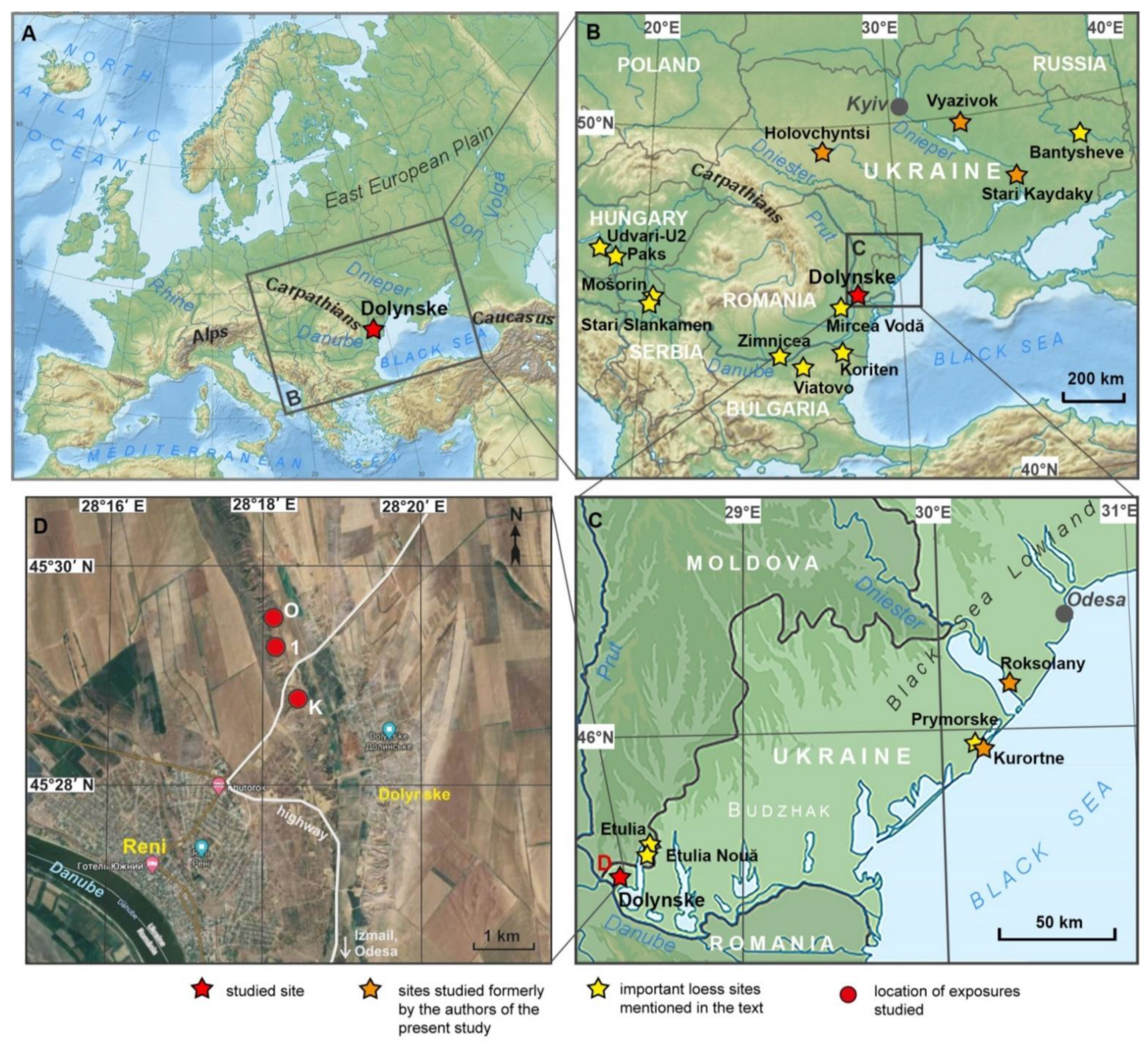


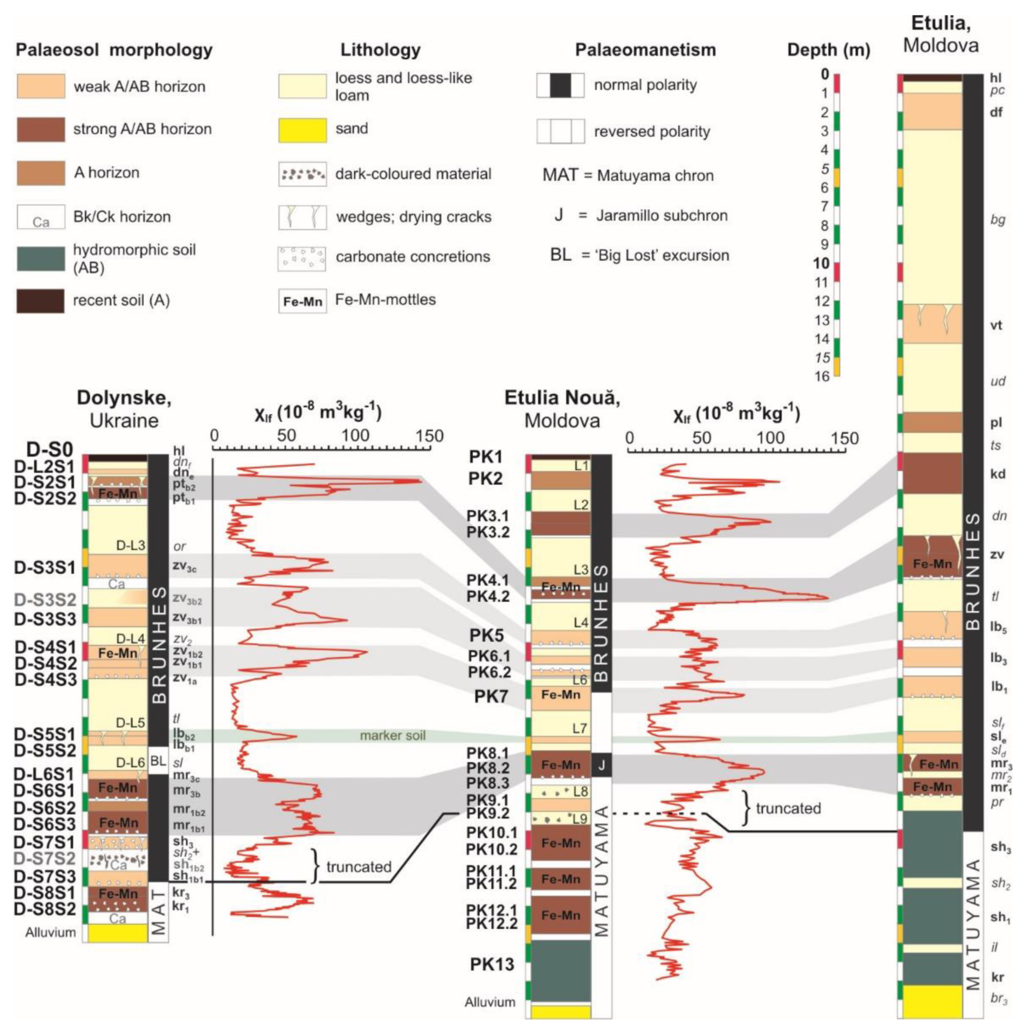

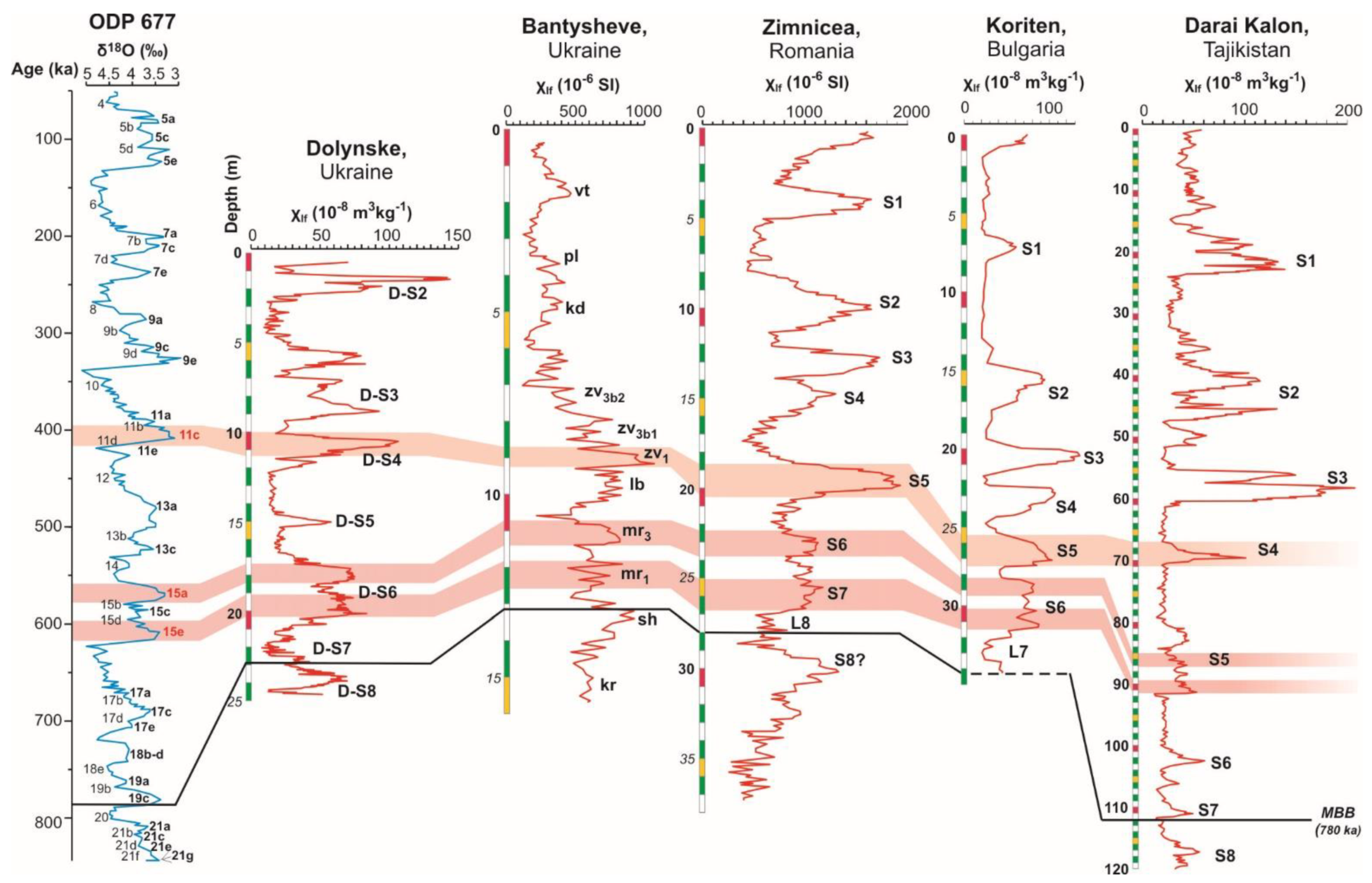

| Etulia, after Veklich and Veklich [214] | Etulia Nouă, after Tsatskin et al. [215,216] | Dolynske (This Study) | |||||
|---|---|---|---|---|---|---|---|
| Palaeosol | MIS | Palaeosol | MIS | Palaeosol | Index | Unit | MIS |
| Vytachiv | 5 | ||||||
| Pryluky | 5 | PK2 | 5 | ||||
| Kaydaky | 7 | PK3 | 7–11 | ||||
| Zavadivka | 9–11 | PK4 | 13–15 | Potyagaylivka | pt | D-S2 | 7 |
| Lubny 5 | 13 | PK5 | 17 | Upper Zavadivka | zv3c | D-S3S1 | 9a |
| Lubny 3 | 15 | PK6 | 19 | zv3b1 | D-S3S3 | 9e | |
| Lubny 1 | 17 | PK7 | 21 | Lower Zavadivka | zv1 | D-S4 | 11 1 |
| Sula 2 | 18b–d | incipient soil | 23 | Lubny | lb | D-S5 | 13 |
| Martonosha | 19–23 | PK8 | 25–27 | Martonosha | mr | D-S6 | 15 1 |
| Shyrokyne 3 | 25–? | PK9 + 10? | 31–33? | Upper Shyrokyne | sh3 | D-S7S1 | 17 |
| Shyrokyne 1 | PK11 + 12? | 35–? | Lower Shyrokyne | sh1b1 | D-S7S3 | 19c | |
| Kryzhanivka | PK13? | Kryzhanivka | kr | D-S8 | 21 | ||
| Gozhik et al. [48,173,174], Bogucki et al. [182] | Tsatskin et al. [215] | Hlavatskyi and Bakhmutov [150] | Corrected Model Presented Here | |||||||
|---|---|---|---|---|---|---|---|---|---|---|
| Palaeosol | MIS | Palaeosol | MIS | Palaeosol | Unit | MIS | Palaeosol | Index | Unit | MIS |
| Prychornomorya | 2 | PK2 | 5 | Vytachiv | R-L1S1 | 3 | Vytachiv | vt | R-L1S1 | 3 |
| Dofinivka 1 | PK3 | 7–11 | Pryluky | R-S1S1 | 5a–c | Pryluky | pl | R-S1S1 | 5a–c | |
| Dofinivka 2 | Kaydaky | R-S1S2 | 5e | Kaydaky | kd | R-S1S2 | 5e | |||
| Vytachiv | 3 | PK4 | 13–15 | Potyagaylivka | R-S2 | 7 | Potyagaylivka | pt | R-S2 | 7 |
| interstadial soil | PK5 | 17 | Upper Zavadivka | R-S3S1 | 9a | Upper Zavadivka | zv3c | R-S3S1 | 9a | |
| Pryluky | 5 | PK6 | 19 | R-S3S2 + 3 | 9c–e | zv3b | R-S3S2 + 3 | 9c–e | ||
| Kaydaky | 7 | PK7 | 21 | Lower Zavadivka | R-S4 | 11 | Lower Zavadivka | zv1 | R-S4 | 11 |
| Potyagaylivka | 9 | incipient soil | 23 | Lubny | R-S5 | 13–15 | Lubny | lb | R-S5 | 13 |
| Zavadivka 1 | 11 | PK8 | 25–27 | Upper Martonosha | R-S6S1 | 17a–c | Martonosha | mr | R-S6 | 15 |
| Zavadivka 2–3 | 11 | PK9 | 31 | Lower Martonosha | R-S6S2 | 17e | Upper Shyrokyne | sh3 | R-S7S1 | 17 |
| Lubny | 13–15 | Lower Shyrokyne | R-S7 | 19 | Lower Shyrokyne | sh1 | R-S7S3 | 19c | ||
| Martonosha | 17–19 | Kryzhanivka | R-S8 | 21 | Kryzhanivka | kr | R-S8 | 21 | ||
| Shyrokyne | 21 | Middle Berezan | R-L9S1 | 23 | Middle Berezan | br2 | R-L9S1 | 23 | ||
| Depth Range (m) | Specimens | N | D (deg) | I (deg) | R | k | α95 (deg) |
|---|---|---|---|---|---|---|---|
| 13.78 ÷ 15.21 | 101-5 ÷ 111-1 | 16 | 238.5 | 8.0 | 8.26 | 1.94 | 37.5 |
| 15.21 ÷ 16.81 | 111-6 ÷ 118A-4; 121-3 | 9 | 220.5 | −31.7 | 6.28 | 2.94 | 36.5 |
| 16.81 ÷ 22.82 | 119-3 ÷ 158-1 | 46 | 346.4 | 67.4 | 25.41 | 2.19 | 19.2 |
| 22.82 ÷ 24.38 | 158-31 ÷ 168-1 | 34 | 197.9 | −52.5 | 18.44 | 2.12 | 23.1 |
| All specimens with normal polarity | 54 | 342.2 | 70.8 | 36.09 | 2.96 | 13.8 | |
| All specimens with reversed polarity | 51 | 211.1 | −48.5 | 36.64 | 3.48 | 12.6 | |
| Age (ka) | GPTS | MIS | Ukraine [157,178,183,196,197,198], Moldova [214] | Ukraine [150] | Romania [9,22] | Bulgaria [8,130] | Serbia [13,14,15] | |
|---|---|---|---|---|---|---|---|---|
| Unit (Stratotype) | Index | |||||||
| 0 | 1 | Holocene | hl | U-S0 | S0 | S0 | V-S0 | |
| 2 | Bug | bg | U-L1L1 | L1L1 | L1LL1 | V-L1S1 | ||
| 3 | Vytachiv | vt | U-L1S1 | L1S1 | L1SS1 | V-L1S1 | ||
| 4 | Uday | ud | U-L1L2 | L1L2 | L1LL2 | V-L1L2 | ||
| 5 | Pryluky + Kaydaky | pl + kd | U-S1 | S1 | S1 | V-S1 | ||
| 6 | Dnipro | dn | U-L2 | L2 | L2 | V-L2 | ||
| 7 | Potyagaylivka | pt | U-S2 | S2 | S2 | V-S2 | ||
| 8 | Oril | or | U-L3 | L3 | L3 | V-L3 | ||
| 9 | Upper Zavadivka | zv3 | U-S3 | S3 + S4 | S3 + S4 | V-S3 + V-S4 | ||
| 10 | Middle Zavadivka | zv2 | U-L4 | L5 | L5 | V-L5 | ||
| 11 | Lower Zavadivka | zv1 | U-S4 | S5 | S5 | V-S5 | ||
| 12 | Tyligul | tl | U-L5 | L6 | L6 | V-L6 | ||
| 13 | Lubny | lb | U-S5 | V-S6 + V-L7S1 | ||||
| 14 | Sula | sl | U-L6 | V-L7L2 | ||||
| 15 | Martonosha | mr | U-S6 | S6 + S7 1/S6 2 | S6 | V-S7 + V-S8 | ||
| 16 | Pryazovya | pr | U-L7 | L8 | L7 | V-L9 (L9LL1) | ||
| 17 | Upper Shyrokyne | sh3 | U-S7S1 | |||||
| 18 | Middle Shyrokyne | sh2 | U-S7L1 | |||||
| 780 | B | 19 | Lower Shyrokyne | sh1 | U-S7S2 + 3 | V-S9 (L9SS1) | ||
| M | 20 | Illichivsk | il | U-L8 | V-L10 (L9LL2) | |||
| 21? | Kryzhanivka | kr | U-S8? | S8? | Red clay | Basal complex | ||
Publisher’s Note: MDPI stays neutral with regard to jurisdictional claims in published maps and institutional affiliations. |
© 2021 by the authors. Licensee MDPI, Basel, Switzerland. This article is an open access article distributed under the terms and conditions of the Creative Commons Attribution (CC BY) license (https://creativecommons.org/licenses/by/4.0/).
Share and Cite
Hlavatskyi, D.; Bakhmutov, V. Early–Middle Pleistocene Magnetostratigraphic and Rock Magnetic Records of the Dolynske Section (Lower Danube, Ukraine) and Their Application to the Correlation of Loess–Palaeosol Sequences in Eastern and South-Eastern Europe. Quaternary 2021, 4, 43. https://doi.org/10.3390/quat4040043
Hlavatskyi D, Bakhmutov V. Early–Middle Pleistocene Magnetostratigraphic and Rock Magnetic Records of the Dolynske Section (Lower Danube, Ukraine) and Their Application to the Correlation of Loess–Palaeosol Sequences in Eastern and South-Eastern Europe. Quaternary. 2021; 4(4):43. https://doi.org/10.3390/quat4040043
Chicago/Turabian StyleHlavatskyi, Dmytro, and Vladimir Bakhmutov. 2021. "Early–Middle Pleistocene Magnetostratigraphic and Rock Magnetic Records of the Dolynske Section (Lower Danube, Ukraine) and Their Application to the Correlation of Loess–Palaeosol Sequences in Eastern and South-Eastern Europe" Quaternary 4, no. 4: 43. https://doi.org/10.3390/quat4040043
APA StyleHlavatskyi, D., & Bakhmutov, V. (2021). Early–Middle Pleistocene Magnetostratigraphic and Rock Magnetic Records of the Dolynske Section (Lower Danube, Ukraine) and Their Application to the Correlation of Loess–Palaeosol Sequences in Eastern and South-Eastern Europe. Quaternary, 4(4), 43. https://doi.org/10.3390/quat4040043