Holocene Sedimentary Record and Coastal Evolution in the Makran Subduction Zone (Iran)

 , ,
, ,
Abstract
:1. Introduction
2. Geological Setting
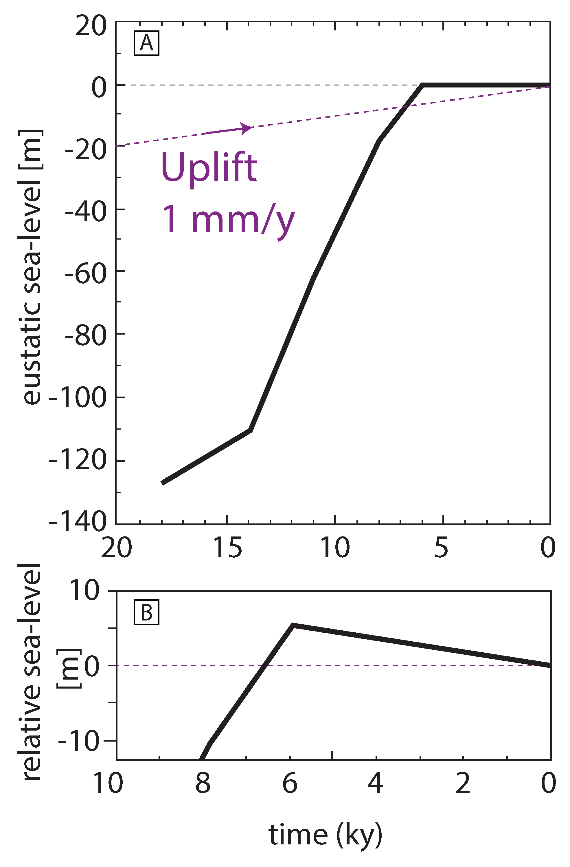
3. Sea-Level Curve
4. Results
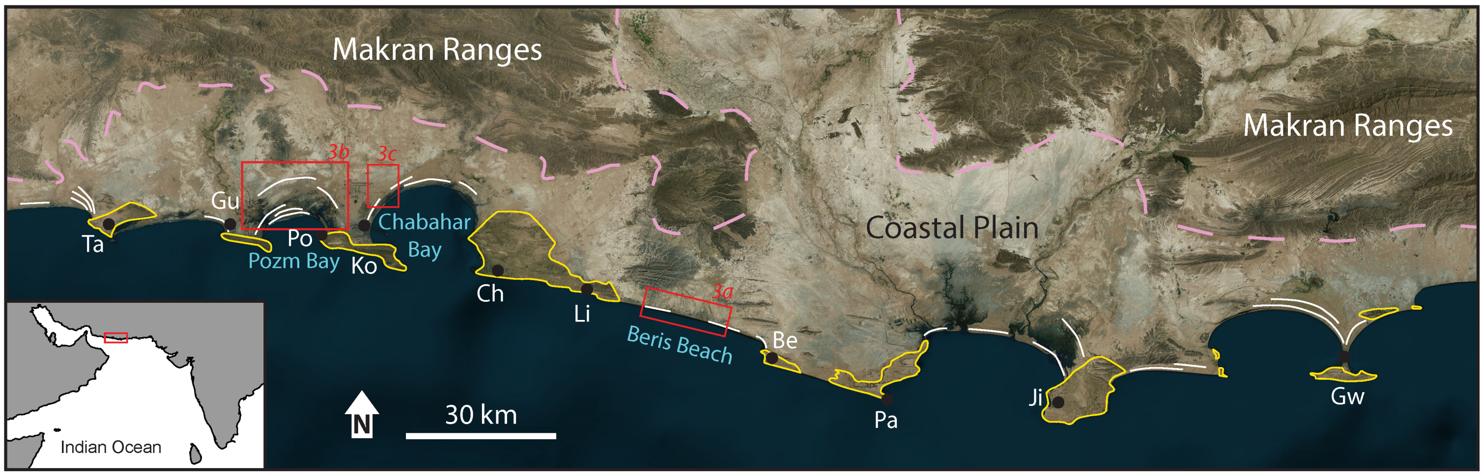
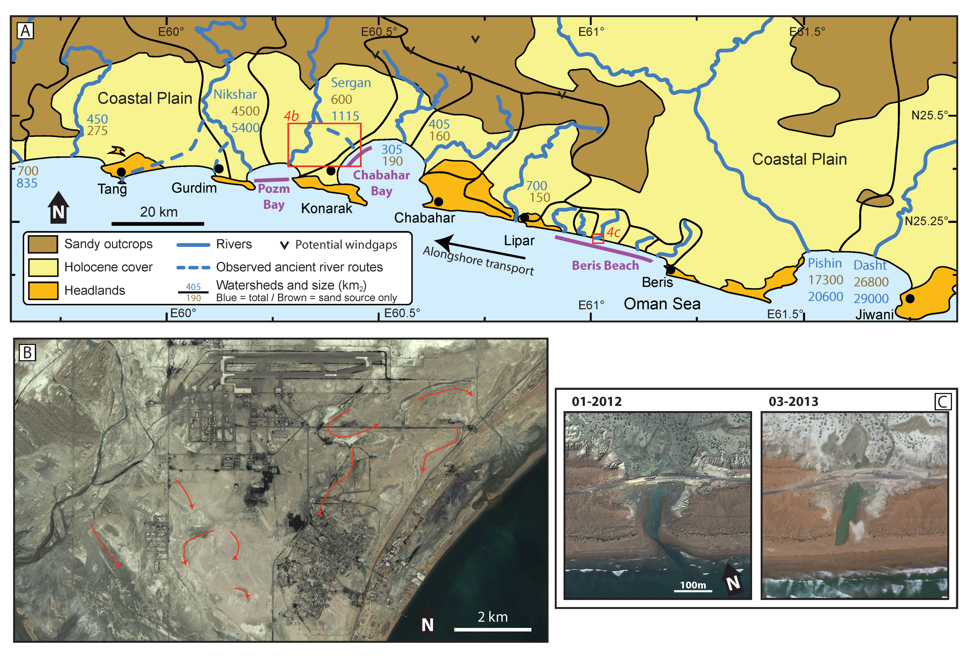
4.1. Makran Coastal Evolution
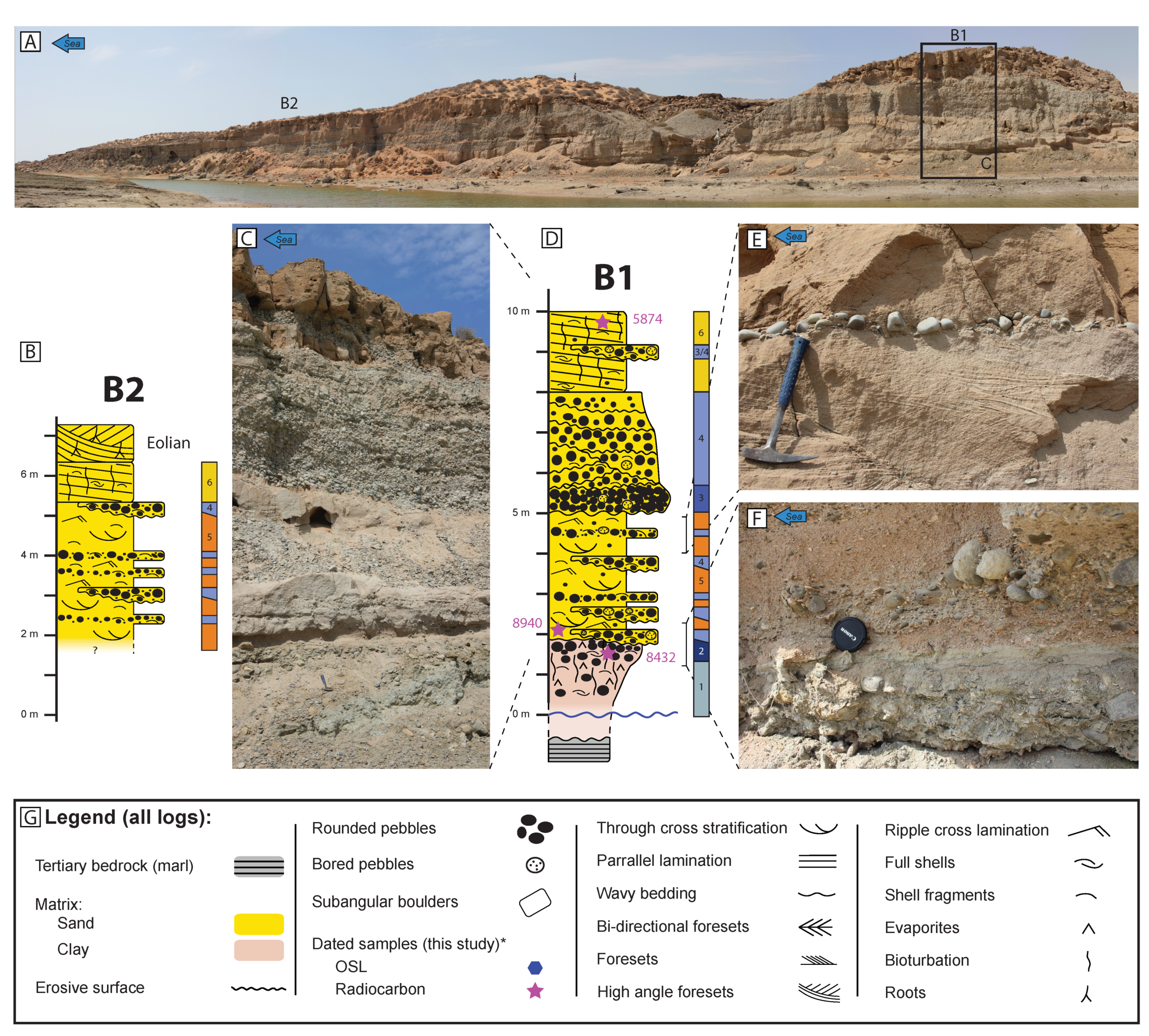
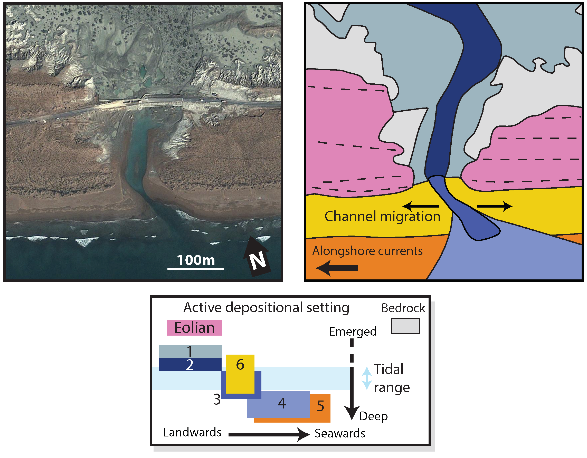
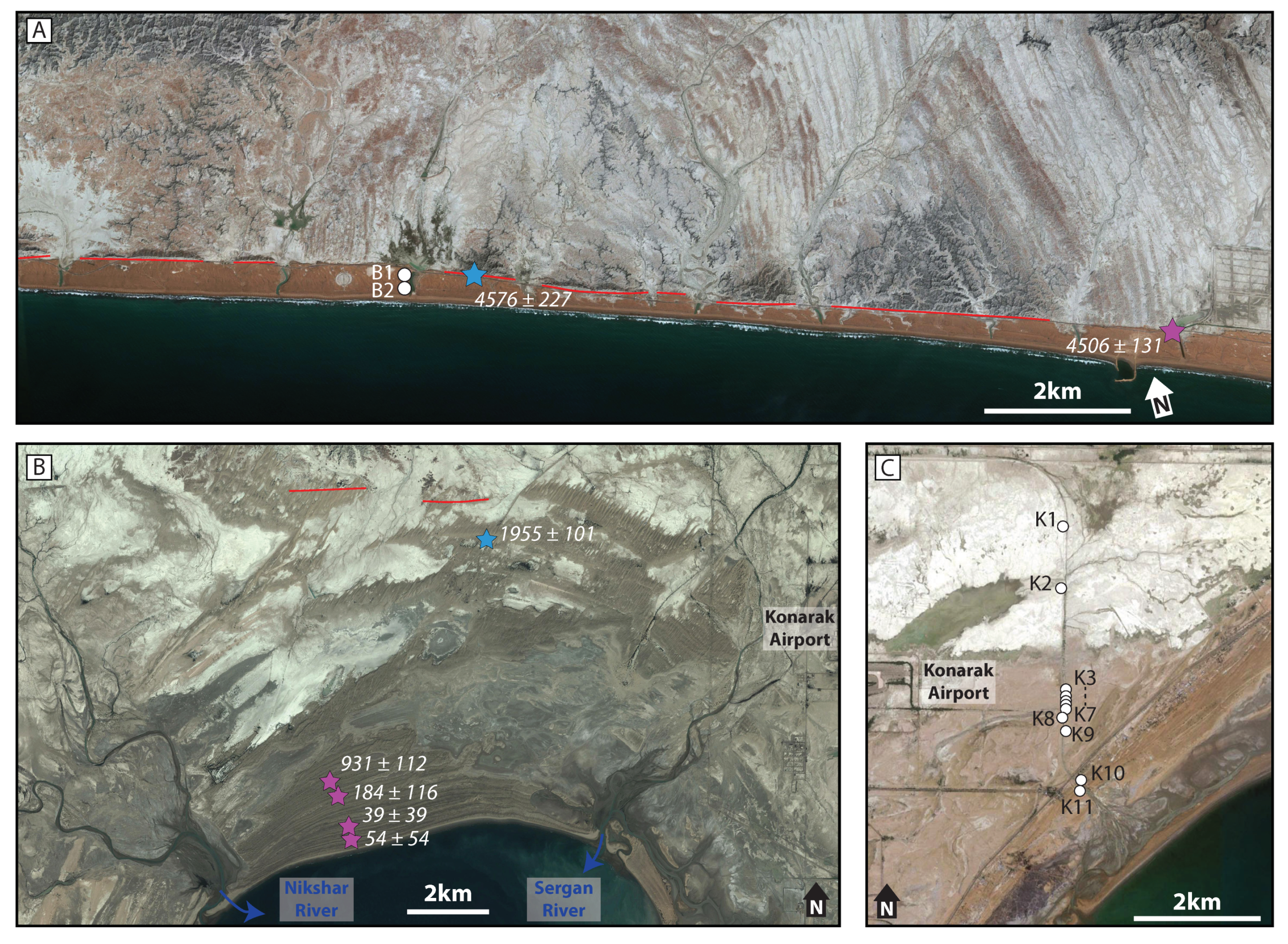
4.2. Beris Beach
Beris Beach Sedimentology
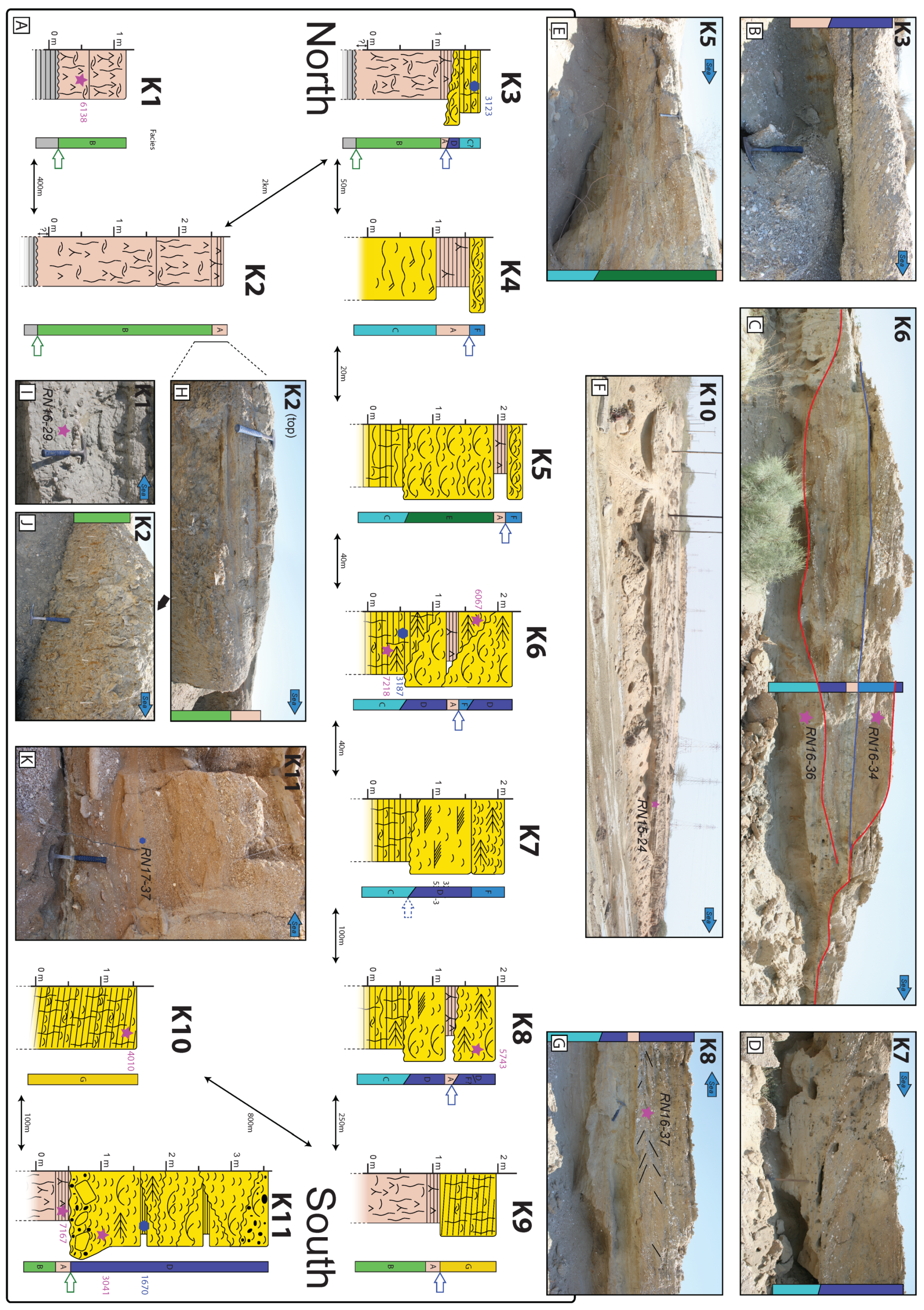
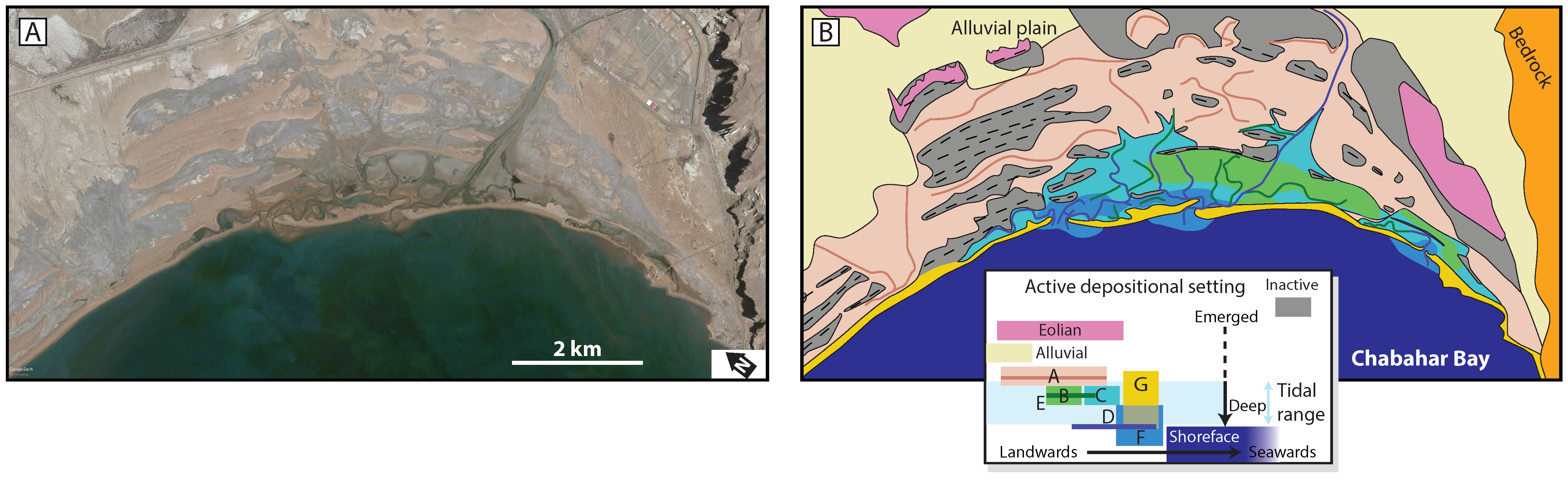
4.3. Chabahar Bay
4.3.1. Chabahar Bay Sedimentology
4.3.2. Timing of the Flooding Event
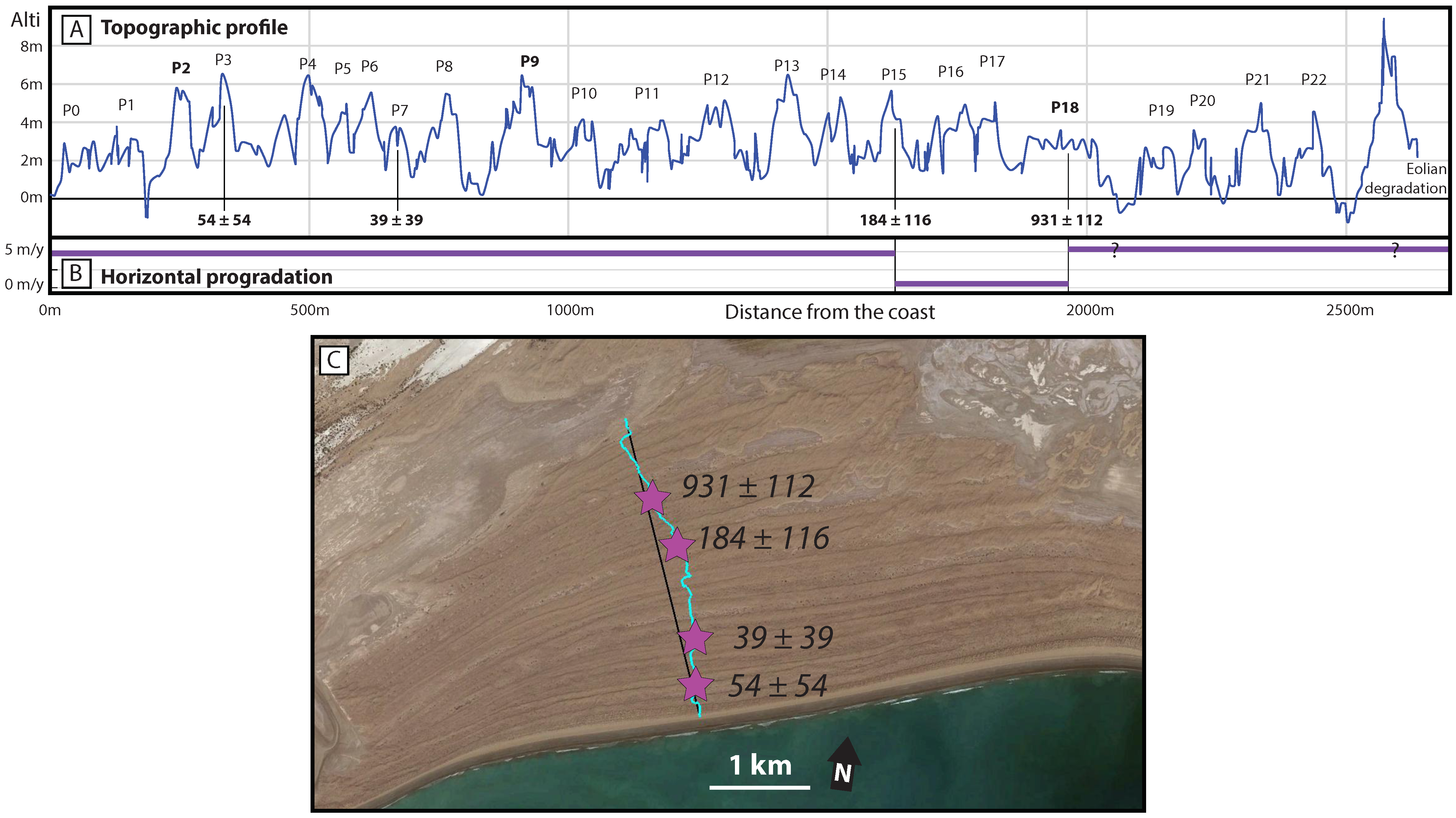
4.4. Pozm Bay
5. Discussion
5.1. Coseismic Signal in Beach Sedimentology?
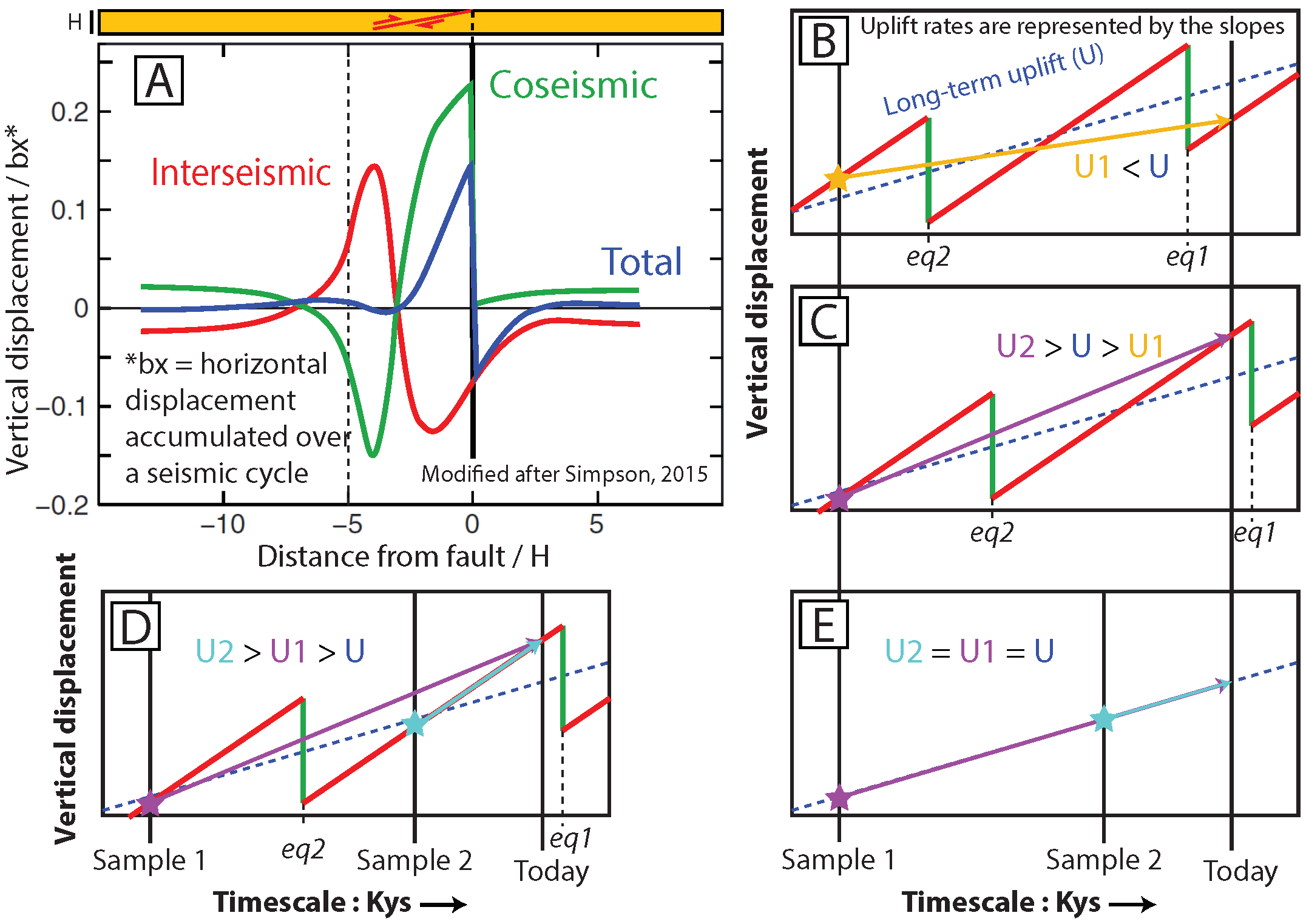
5.2. Holocene Uplift Rates
6. Conclusions
Supplementary Materials
Author Contributions
Funding
Acknowledgments
Conflicts of Interest
References
- Falcon, N.L. Raised beaches and terraces of the Iranian Makran coast. Geogr. J. 1947, 109, 149–151. [Google Scholar]
- Snead, R.J. Recent Morphological changes along the coast of West Pakistan. Ann. Assoc. Am. Geogr. 1967, 57, 550–565. [Google Scholar] [CrossRef]
- Reyss, J.L.; Pirazzoli, P.A.; Haghipour, A.; Hatté, C.; Fontugne, M. Quaternary marine terraces and tectonic uplift rates on the south coast of Iran. Geol. Soc. Lond. Spec. Publ. 1998, 146, 225–237. [Google Scholar] [CrossRef]
- Byrne, D.E.; Sykes, L.R.; Davis, D.M. Great Thrust Earthquakes and Aseismic Slip Along the Plate Boundary of the Makran Subduction Zone. J. Geophys. Res. Earth 1992, 97, 449–478. [Google Scholar] [CrossRef]
- Page, W.D.; Alt, J.N.; Cluff, L.S.; Plafker, G. Evidence for the recurrence of large-magnitude earthquake along the Makran coast of Iran and Pakistan. Tectonophysics 1979, 52, 533–547. [Google Scholar] [CrossRef]
- Ambraseys, N.N.; Melville, C.P. A History of Persian Earthquakes; Cambridge University Press: Cambridge, UK, 1982. [Google Scholar] [CrossRef]
- Quittmeyer, R.C.; Jacob, K.H. Historical and Modern seismicity of Pakistan, Afghanistan, Northwestern India, and Southeastern Iran. Bull. Seismol. Soc. Am. 1979, 69, 773–823. [Google Scholar]
- Heidarzadeh, M.; Pirooz, M.D.; Zaker, N.H.; Yalciner, A.C.; Mokhtari, M.; Esmaeily, A. Historical tsunami in the Makran Subduction Zone off the southern coasts of Iran and Pakistan and results of numerical modeling. Ocean Eng. 2008, 35, 774–786. [Google Scholar] [CrossRef]
- Musson, R.M.W. Subduction in the Western Makran: The historian’s contribution. J. Geol. Soc. Lond. 2009, 166, 387–391. [Google Scholar] [CrossRef]
- Rajendran, C.P.; Rajendran, K.; Shah-hosseini, M.; Beni, A.N.; Nautiyal, C.M.; Andrews, R. The hazard potential of the western segment of the Makran subduction zone, northern Arabian Sea. Nat. Hazards 2013, 65, 219–239. [Google Scholar] [CrossRef]
- Smith, G.L.; McNeill, L.C.; Wang, K.; He, J.; Henstock, T.J. Thermal structure and megathrust seismogenic potential of the Makran subduction zone. Geophys. Res. Lett. 2013, 40, 1528–1533. [Google Scholar] [CrossRef] [Green Version]
- Penney, C.; Tavakoli, F.; Saadat, A.; Nankali, H.R.; Sedighi, M.; Khorrami, F.; Sobouti, F.; Rafi, Z.; Copley, A.; Jackson, J.; et al. Megathrust and accretionary wedge properties and behaviour in the Makran subduction zone. Geophys. J. Int. 2017, 209, 1800–1830. [Google Scholar] [CrossRef]
- Darwin, C. Geological Observations on South America; Cambridge University Press: Cambridge, UK, 1846. [Google Scholar] [CrossRef]
- Atwater, B.F.; Musumi-Rokkaku, S.; Satake, K.; Tsuji, Y.; Ueda, K.; Yamaguchi, D.K. The Orphan Tsunami of 1700—Japanese Clues to a Parent Earthquake in North America; U.S. Geological Survey Professional Paper 1707; University of Washington Press: Seattle, WA, USA, 2005. [CrossRef]
- McSaveney, M.J.; Graham, I.J.; Begg, J.G.; Beu, A.G.; Hull, A.G.; Kim, K.; Zondervan, A. Late Holocene uplift of beach ridges at Turakirae Head, south Wellington coast, New Zealand. N. Z. J. Geol. Geophys. 2006, 49, 337–358. [Google Scholar] [CrossRef]
- Monecke, K.; Templeton, C.K.; Finger, W.; Houston, B.; Luthi, S.; Mcadoo, B.G.; Meilianda, E.; Storms, J.E.A.; Walstra, D.; Amna, R.; et al. Beach ridge patterns in West Aceh, Indonesia, and their response to large earthquakes along the northern Sunda trench. Quat. Sci. Rev. 2015, 113, 159–170. [Google Scholar] [CrossRef]
- Vita-Finzi, C. Recent coastal deformnation near the Strait of Hormuz. Proc. R. Soc. Lond. 1982, 382, 441–457. [Google Scholar] [CrossRef]
- Snead, R.J. Uplifted Marine Terraces along the Makran coast of Pakistan and Iran. In Himalaya to the Sea; Shroder, J.F.J., Ed.; Routledge: London, UK, 1993; pp. 327–362. [Google Scholar]
- Normand, R.; Simpson, G.; Herman, F.; Biswas, R.H.; Bahroudi, A.; Schneider, B. Dating and morpho-stratigraphy of uplifted marine terraces in the Makran subduction zone (Iran). Earth Surf. Dyn. 2019, 7, 321–344. [Google Scholar] [CrossRef] [Green Version]
- Pararas-Carayannis, G. The Potential of Tsunami Generation along the Makran Subduction. Sci. Tsunami Hazards 2006, 24, 358–384. [Google Scholar]
- Hafeez, H. The potential of tsunami generation along Karachi and the Makran coast of Pakistan. Pak. J. Meteorol. 2007, 4, 25–40. [Google Scholar] [CrossRef]
- Rajendran, C.P.; Ramanamurthy, M.V.; Reddy, N.T.; Rajendran, K. Hazard implications of the late arrival of the 1945 Makran tsunami. Curr. Sci. 2008, 95, 1739–1743. [Google Scholar]
- Heidarzadeh, M.; Kijko, A. A probabilistic tsunami hazard assessment for the Makran subduction zone at the northwestern Indian Ocean. Nat. Hazards 2011, 56, 577–593. [Google Scholar] [CrossRef]
- Schneider, B.; Hoffmann, G.; Reicherter, K. Scenario-based tsunami risk assessment using a static flooding approach and high-resolution digital elevation data: An example from Muscat in Oman. Glob. Planet. Chang. 2016, 139, 183–194. [Google Scholar] [CrossRef]
- Hoffmann, G.; Reicherter, K.; Wiatr, T.; Grützner, C.; Rausch, T. Block and boulder accumulations along the coastline between Fins and Sur (Sultanate of Oman): Tsunamigenic remains? Nat. Hazards 2013, 65, 851–873. [Google Scholar] [CrossRef]
- Donato, S.V.; Reinhardt, E.G.; Boyce, J.I.; Pilarczyk, J.E.; Jupp, B.P. Particle-size distribution of inferred tsunami deposits in Sur Lagoon, Sultanate of Oman. Mar. Geol. 2009, 257, 54–64. [Google Scholar] [CrossRef]
- Shah-Hosseini, M.; Morhange, C.; Naderi Beni, A.; Marriner, N.; Lahijani, H.; Hamzeh, M.; Sabatier, F. Coastal boulders as evidence for high-energy waves on the Iranian coast of Makran. Mar. Geol. 2011, 290, 17–28. [Google Scholar] [CrossRef]
- Shah-Hosseini, M.; Ghanavati, E.; Morhange, C.; Naderi Beni, A.; Lahijani, H.A.; Hamzeh, M.A. The evolution of Chabahar beach ridge system in SE Iran in response to Holocene relative sea level changes. Geomorphology 2018, 318, 139–147. [Google Scholar] [CrossRef]
- Gharibreza, M. Evolutionary trend of paleoshorelines in the Coastal Makran zone (Southeast Iran) since the mid-Holocene. Quat. Int. 2016, 392, 203–212. [Google Scholar] [CrossRef]
- Gharibreza, M.R.; Motamed, A. Late Quaternary Paleoshorelines and Sedimentary Sequences in Chabahar Bay (Southeast of Iran). J. Coast. Res. 2006, 226, 1499–1504. [Google Scholar] [CrossRef]
- Zare, M.; Amini, H.; Yazdi, P.; Sesetyan, K.; Demircioglu, M.B.; Kalafat, D.; Erdik, M.; Giardini, D.; Khan, M.A.; Tsereteli, N. Recent developments of the Middle East catalog. J. Seismol. 2014, 18, 749–772. [Google Scholar] [CrossRef]
- Smith, G.; McNeill, L.; Henstock, I.J.; Bull, J. The structure and fault activity of the Makran accretionary prism. J. Geophys. Res. Solid Earth 2012, 117, 1–17. [Google Scholar] [CrossRef]
- Vernant, P.; Nilforoushan, F.; Hatzfeld, D.; Abbassi, M.R.; Vigny, C.; Masson, F.; Nankali, H.; Martinod, J.; Ashtiani, A.; Bayer, R.; et al. Present-day crustal deformation and plate kinematics in the Middle East constrained by GPS measurements in Iran and northern Oman. Geophys. J. Int. 2004, 157, 381–398. [Google Scholar] [CrossRef] [Green Version]
- Masson, F.; Anvari, M.; Djamour, Y.; Walpersdorf, A.; Tavakoli, F.; Daignières, M.; Nankali, H.; Van Gorp, S. Large-scale velocity field and strain tensor in Iran inferred from GPS measurements: New insight for the present-day deformation pattern within NE Iran. Geophys. J. Int. 2007, 170, 436–440. [Google Scholar] [CrossRef]
- Khan, M.A.; Bendick, R.; Bhat, M.I.; Bilham, R.; Kakar, D.M.; Khan, S.F.; Lodi, S.H.; Qazi, M.S.; Singh, B.; Szeliga, W.; et al. Preliminary geodetic constraints on plate boundary deformation on the western edge of the Indian plate from TriGGnet (Tri-University GPS Geodesy Network). J. Himal. Earth Sci. 2008, 41, 71–87. [Google Scholar]
- Vita-Finzi, C. Neotectonics in the Arabian Sea coasts. Geol. Soc. Lond. Spec. Publ. 2002, 195, 87–96. [Google Scholar] [CrossRef]
- Burg, J.-P.; Dolati, A.; Bernoulli, D.; Smit, J. Structural style of the Makran Tertiary accretionary complex in SE-Iran. In Lithosphere Dynamics and Sedimentary Basins: The Arabian Plate and Analogues; Al Hosani, K., Roure, F., Ellison, R., Lokier, S., Eds.; Springer: Berlin, Germany, 2013; pp. 239–259. [Google Scholar]
- McCall, G.J.H. A summary of the geology of the Iranian Makran. Geol. Soc. Lond. Spec. Publ. 2002, 195, 147–204. [Google Scholar] [CrossRef]
- Harrison, J.V. Coastal Makran: Discussion. Geogr. J. 1941, 97, 1–15. [Google Scholar] [CrossRef]
- Harms, J.C.; Cappel, H.N.; Francis, D.C. The Makran Coast of Pakistan: It’s Stratigraphy and Hydrocarbon Potential. In Marine Geology and Oceanography of Arabian Sea and Coastal Pakistan; Haq, B.U., Milliman, J.D., Eds.; Van Nostrand Reinhold Company Inc.: New York, NY, USA, 1984; pp. 3–26. [Google Scholar]
- Ghorashi, M. Late Cainozoic faulting in S.E. Iran. Ph.D. Thesis, University College London, London, UK, 1978. [Google Scholar]
- Blanford, W.T. Note on the geological formations seen along the coasts of Bilúchístán and Persia from Karáchí to the head of the Persian Gulf, and on some of the Gulf Islands. Rec. Geol. Surv. India 1872, 5, 41–45. [Google Scholar]
- Stiffe, A.W. On the Mud-craters and Geological Structure of the Mekran Coast. Q. J. Geol. Soc. Lond. 1874, 30, 50–53. [Google Scholar] [CrossRef]
- Ivory, S.J.; Lézine, A.M. Climate and environmental change at the end of the Holocene Humid Period: A pollen record off Pakistan. C. R. Geosci. 2009, 341, 760–769. [Google Scholar] [CrossRef]
- Prins, M.A.; Postma, G.; Cleveringa, J.; Cramp, A.; Kenyon, N.H. Controls on terrigenous sediment supply to the Arabian Sea during the late quaternary: The Indus fan. Mar. Geol. 2000, 169, 327–349. [Google Scholar] [CrossRef]
- Bourget, J.; Zaragosi, S.; Ellouz-Zimmermann, S.; Ducassou, E.; Prins, M.A.; Garlan, T.; Lanfumey, V.; Schneider, J.L.; Rouillard, P.; Giraudeau, J. Highstand vs. lowstand turbidite system growth in the Makran active margin: Imprints of high-frequency external controls on sediment delivery mechanisms to deep water systems. Mar. Geol. 2010, 274, 187–208. [Google Scholar] [CrossRef]
- Sanlaville, P.; Besenval, R.; Evin, J.; Prieur, A. Evolution de la région littorale du Makran pakistanais à l’Holocène. Paléorient 1991, 17, 3–18. [Google Scholar] [CrossRef]
- Haghipour, N.; Burg, J.P.; Ivy-Ochs, S.; Hajdas, I.; Kubik, P.; Christl, M. Correlation of fluvial terraces and temporal steady-state incision on the onshore Makran accretionary wedge in southeastern Iran: Insight from channel profiles and 10Be exposure dating of strath terraces. Bull. Geol. Soc. Am. 2014, 127, 560–583. [Google Scholar] [CrossRef]
- Little, R.D. Terraces of the Makran Coast of Iran and Parts of West Pakistan. Ph.D. Thesis, University of Southern California, Los Angeles, CA, USA, 1972. [Google Scholar]
- Saket, A.; Etemad-shahidi, A. Wave energy potential along the northern coasts of the Gulf of Oman, Iran. Renew. Energy 2012, 40, 90–97. [Google Scholar] [CrossRef] [Green Version]
- Saket, A.; Etemad-shahidi, A.; Moeini, M.H. Evaluation of ECMWF wind data for wave hindcast in Chabahar zone. J. Coast. Res. 2013, 380–385. [Google Scholar] [CrossRef]
- Vita-Finzi, C. 14C Dating of recent crustal movements in the Persian Gulf and Iranian Makran. Radiocarbon 1980, 22, 763–773. [Google Scholar] [CrossRef]
- Sanlaville, P.; Dalongeville, R. L’évolution des espaces littoraux du golfe Persique et du golfe d’Oman depuis la phase finale de la transgression post-glaciaire. Paléorient 2005, 31, 9–26. [Google Scholar] [CrossRef]
- Pirazzoli, P.A. World Atlas of Holocene Sea-Level Changes; Elsevier B.V.: Amsterdam, The Netherlands, 1991. [Google Scholar]
- Lambeck, K. Shoreline reconstructions for the Persian Gulf since the last glacial maximum. Earth Planet. Sci. Lett. 1996, 142, 43–57. [Google Scholar] [CrossRef]
- Normand, R.; Simpson, G.; Herman, F.; Biswas, R.H.; Bahroudi, A. Data for: Holocene sedimentary record and coastal evolution in the Makran subduction zone (Iran). Zenodo 2019. [Google Scholar] [CrossRef]
- Bronk Ramsey, C.; Lee, S. Recent and Planned Developments of the Program OxCal. Radiocarbon 2013, 55, 720–730. [Google Scholar] [CrossRef]
- Reimer, P.J.; Bard, E.; Bayliss, A.; Beck, J.W.; Blackwell, P.G.; Ramsey, C.B.; Buck, C.E.; Cheng, H.; Edwards, R.L.; Friedrich, M.; et al. IntCal13 and Marine13 Radiocarbon Age Calibration Curves 0–50,000 Years cal BP. Radiocarbon 2013, 55, 1869–1887. [Google Scholar] [CrossRef]
- Valvo, L.M.; Murray, A.B.; Ashton, A. How does underlying geology affect coastline change? An initial modeling investigation. J. Geophys. Res. 2006, 111. [Google Scholar] [CrossRef]
- Limber, P.W.; Murray, A.B. Unraveling the dynamics that scale cross-shore headland relief on rocky coastlines: 2. Model predictions and initial tests. J. Geophys. Res. Earth Surf. 2014, 119, 874–891. [Google Scholar] [CrossRef]
- Limber, P.W.; Murray, A.B.; Adams, P.N.; Goldstein, E.B. Unraveling the dynamics that scale cross-shore headland relief on rocky coastlines: 1. Model development. J. Geophys. Res. Earth Surf. 2014, 119, 854–873. [Google Scholar] [CrossRef]
- Bird, E. Coastal Geomorphology, An Introduction; Wiley: Hoboken, NJ, USA, 2000. [Google Scholar]
- Ashton, A.; Murray, A.B.; Arnault, O. Formation of coastline features by large-scale instabilities induced by high-angle waves. Nature 2001, 414, 296–300. [Google Scholar] [CrossRef] [PubMed]
- Tamura, T. Beach ridges and prograded beach deposits as palaeoenvironment records. Earth-Sci. Rev. 2012, 114, 279–297. [Google Scholar] [CrossRef]
- Schwanghart, W.; Kuhn, N.J. TopoToolbox: A set of Matlab functions for topographic analysis. Environ. Model. Softw. 2010, 25, 770–781. [Google Scholar] [CrossRef]
- Schwanghart, W.; Scherler, D. Short Communication: TopoToolbox 2—MATLAB-based software for topographic analysis and modeling in Earth surface sciences. Earth Surf. Dyn. 2014, 2, 1–7. [Google Scholar] [CrossRef]
- Hurst, M.D.; Barkwith, A.; Ellis, M.A.; Thomas, C.W.; Murray, A.B. Exploring the sensitivities of crenulate bay shorelines to wave climates using a new vector-based one-line model. J. Geophys. Res. Earth Surf. 2015, 120, 2586–2608. [Google Scholar] [CrossRef] [Green Version]
- Yasso, W.E. Plan Geometry of Headland-Bay Beaches. J. Geol. 1965, 73, 702–714. [Google Scholar] [CrossRef]
- Axe, P.; Ilic, S.; Chadwick, A. Evaluation of beach modelling techniques behind detached breakwaters. Coast. Eng. Proc. 1996, 25, 2036–2049. [Google Scholar] [CrossRef]
- Otvos, E.G. Beach ridges—Definitions and significance. Geomorphology 2000, 32, 83–108. [Google Scholar] [CrossRef]
- Normand, R.; Simpson, G.; Herman, F.; Biswas, R.H.; Bahroudi, A.; Schneider, B. Data from: Dating and morpho-stratigraphy of uplifted marine terraces in the Makran subduction zone (Iran). Zenodo 2018. [Google Scholar] [CrossRef]
- Schneider, B.; Hoffmann, G.; Falkenroth, M.; Grade, J. Tsunami and storm sediments in Oman: Characterizing extreme wave deposits using terrestrial laser scanning. J. Coast. Conserv. 2018. [Google Scholar] [CrossRef]
- Plafker, G. Tectonics of the March 27, 1964 Alaska Earthquake. In The Alaska Earthquake, March 27, 1964, Regional Effects; U.S. Government Printing Office: Washington, DC, USA, 1966; p. 74. [Google Scholar]
- Plafker, G.; Savage, J.C. Mechanism of the Chilean Earthquakes of May 21 and 22, 1960. Geol. Soc. Am. Bull. 1970, 81, 1001–1030. [Google Scholar] [CrossRef]
- Sato, T.; Matsu’ura, M. Cyclic crustal movement, steady uplift of marine terraces, and evolution of the island arc-trench system in southwest Japan. Geophys. J. Int. 1992, 111, 617–629. [Google Scholar] [CrossRef] [Green Version]
- Farías, M.; Vargas, G.; Tassara, A.; Carretier, S.; Baize, S.; Melnick, D.; Bataille, K. Land-Level Changes Produced by the Mw 8.8 2010 Chilean Earthquake. Science 2010, 329, 916. [Google Scholar] [CrossRef]
- Ota, Y.; Yamaguchi, M. Holocene coastal uplift in the western Pacific Rim in the context of late Quaternary uplift. Quat. Int. 2004, 120, 105–117. [Google Scholar] [CrossRef]
- Pedoja, K.; Husson, L.; Johnson, M.E.; Melnick, D.; Witt, C.; Pochat, S.; Nexer, M.; Delcaillau, B.; Pinegina, T.; Poprawski, Y.; et al. Coastal staircase sequences reflecting sea-level oscillations and tectonic uplift during the Quaternary and Neogene. Earth-Sci. Rev. 2014, 132, 13–38. [Google Scholar] [CrossRef]
- Pinegina, T.K.; Bourgeois, J.; Kravchunovskaya, E.A.; Lander, A.V.; Arcos, M.E.M.; Pedoja, K.; MacInnes, B.T. A nexus of plate interaction: Vertical deformation of holocene wave-built terraces on the kamchatsky peninsula (kamchatka, russia). Bull. Geol. Soc. Am. 2013, 125, 1554–1568. [Google Scholar] [CrossRef]
- Wesson, R.L.; Melnick, D.; Cisternas, M.; Moreno, M.; Ely, L.L. Vertical deformation through a complete seismic cycle at Isla Santa María, Chile. Nat. Geosci. 2015, 8, 547–553. [Google Scholar] [CrossRef]
- Simpson, G. Accumulation of permanent deformation during earthquake cycles on reverse faults. J. Geophys. Res. Solid Earth 2015, 120, 1958–1974. [Google Scholar] [CrossRef]


| Sample | Area | Radiocarbon Age | Comments ** | Beach Progradation Rate | |
|---|---|---|---|---|---|
| Conventional ± 1σ | Calibrated ± 2σ * | ||||
| BP | Cal BP | m/year | |||
| RN15-P3 | Pozm Bay | 590 ± 30 | 54 ± 54 | 290m f.c. | >0.6 |
| RN15-P7 | Pozm Bay | 490 ± 30 | 39 ± 39 | 660m f.c. | >3.3 |
| RN15-P15 | Pozm Bay | 810 ± 30 | 184 ± 116 | 1450m f.c. | >4.8 |
| RN15-P18 | Pozm Bay | 1620 ± 30 | 931 ± 112 | 1840m f.c. | >0.6 |
| RN15-24 | Chabahar Bay | 4240 ± 30 | 4010 ± 135 | 1500m f.c. | 0.4 |
| RN16-18 | Chabahar Bay | 6883 ± 22 | 7167 ± 101 | ||
| RN16-19 | Chabahar Bay | 3465 ± 20 | 3041 ± 121 | ||
| RN16-29 | Chabahar Bay | 5969 ± 21 | 6138 ± 117 | In life position | |
| RN16-34 | Chabahar Bay | 5903 ± 21 | 6067 ± 113 | ||
| RN16-36 | Chabahar Bay | 6915 ± 22 | 7218 ± 84 | ||
| RN16-37 | Chabahar Bay | 5602 ± 21 | 5743 ± 115 | ||
| RN15-89 | Beris Beach | 4590 ± 30 | 4506 ± 131 | 460m f.c. | 0.1 |
| RN16-11 | Beris Beach | 5744 ± 21 | 5874 ± 107 | ||
| RN16-41 | Beris Beach | 8200 ± 23 | 8432 ± 88 | ||
| RN16-44 | Beris Beach | 8612 ± 23 | 8940 46 | ||
| Area | Location | Sample | Paleodose CAM ± 1σ | N° of Aliquots | RSD | OD | Env. Dose | Age ± 1σ |
|---|---|---|---|---|---|---|---|---|
| [Gy] | Out of 24 | % | % | [Gy/ka] | [yr] | |||
| Pozm Bay | 7 km from the coastline | RN17-28 | 2.710 ± 0.121 | 23 | 22.3 | 20 | 1.386 ± 0.04 | 1955 ± 101 |
| Chabahar Bay | K3, Above FS | RN17-35 | 4.489 ± 0.206 | 24 | 23.6 | 21 | 1.438 ± 0.04 | 3123 ± 163 |
| Chabahar Bay | K6, Below FS | RN17-36 | 4.368 ± 0.230 | 24 | 21.0 | 25 | 1.371 ± 0.03 | 3187 ± 186 |
| Chabahar Bay | K11 | RN17-37 | 2.287 ± 0.073 | 24 | 17.2 | 15 | 1.369 ± 0.03 | 1670 ± 67 |
| Beris Beach | At the base of the cliff | RN17-44 | 5.929 ± 0.242 | 24 | 23.1 | 19 | 1.296 ± 0.04 | 4576 ± 227 |
| Facies | Short Description | Depositional Environment |
|---|---|---|
| Beris Beach | ||
| 1 | Matrix supported, fine-grained laminated deposit | Lagoon |
| 2 | Conglomerate, clay matrix | Lagoon with fluvial input |
| 3 | Conglomerate, no matrix | Fluvial channel |
| 4 | Conglomerate, sandy matrix | Mouth bar |
| 5 | Well-sorted sandstone. Cross stratifications | Shoreface |
| 6 | Horizontally laminated well sorted sandstone | Beach |
| Chabahar Bay | ||
| A | Laminated fine-grained deposit, evaporites | Supratidal flats |
| B | Heavily bioturbated fine-grained deposit | Intertidal ponds |
| C | Sandy deposits, wavy beddings | Intertidal lagoon |
| D | Erosive base, channelised, bi-directional cross bedding | Tidal channel |
| E | Same as D, with occasional <20 cm thick mud drapes | Tidal channel |
| F | Same as D without the channelised morphology | Intertidal/subtidal |
| G | Horizontally laminated well sorted sandstone | Beach |
| Area | Sample | Deposits | Age ± 2σ | Mean Uplift Rate Since Age | Pleistocene Uplift Rate [19] |
|---|---|---|---|---|---|
| [years] | [mm/year] | [mm/year] | |||
| Chabahar Bay | RN15-24 | Beach | 4010 ± 135 | 1.29 ± 0.9 | ~0.6 |
| RN16-18 | Lagoon | 7167 ± 101 | 1.88 ± 0.2 | ~0.6 | |
| RN16-29 | Lagoon | 6138 ± 117 | 1.38 ± 0.4 | ~0.6 | |
| Beris Beach | RN15-89 | Beach | 4506 ± 131 | 2.92 ± 1.2 | 1 to 4 |
| RN16-41 | Lagoon | 8432 ± 88 | 3.38 ± 0.2 | 1 to 4 | |
| RN17-44 (OSL) | Beach | 4576 ± 454 | 3.75 ± 1.8 | 1 to 4 |
© 2019 by the authors. Licensee MDPI, Basel, Switzerland. This article is an open access article distributed under the terms and conditions of the Creative Commons Attribution (CC BY) license (http://creativecommons.org/licenses/by/4.0/).
Share and Cite
Normand, R.; Simpson, G.; Herman, F.; Biswas, R.H.; Bahroudi, A. Holocene Sedimentary Record and Coastal Evolution in the Makran Subduction Zone (Iran). Quaternary 2019, 2, 21. https://doi.org/10.3390/quat2020021
Normand R, Simpson G, Herman F, Biswas RH, Bahroudi A. Holocene Sedimentary Record and Coastal Evolution in the Makran Subduction Zone (Iran). Quaternary. 2019; 2(2):21. https://doi.org/10.3390/quat2020021
Chicago/Turabian StyleNormand, Raphaël, Guy Simpson, Frédéric Herman, Rabiul Haque Biswas, and Abbas Bahroudi. 2019. "Holocene Sedimentary Record and Coastal Evolution in the Makran Subduction Zone (Iran)" Quaternary 2, no. 2: 21. https://doi.org/10.3390/quat2020021
APA StyleNormand, R., Simpson, G., Herman, F., Biswas, R. H., & Bahroudi, A. (2019). Holocene Sedimentary Record and Coastal Evolution in the Makran Subduction Zone (Iran). Quaternary, 2(2), 21. https://doi.org/10.3390/quat2020021