
The Lowermost Tejo River Terrace at Foz do Enxarrique, Portugal: A Palaeoenvironmental Archive from c. 60–35 ka and Its Implications for the Last Neanderthals in Westernmost Iberia

 ,
,  , , , , , , , ,
  , , and
Abstract
1. Introduction
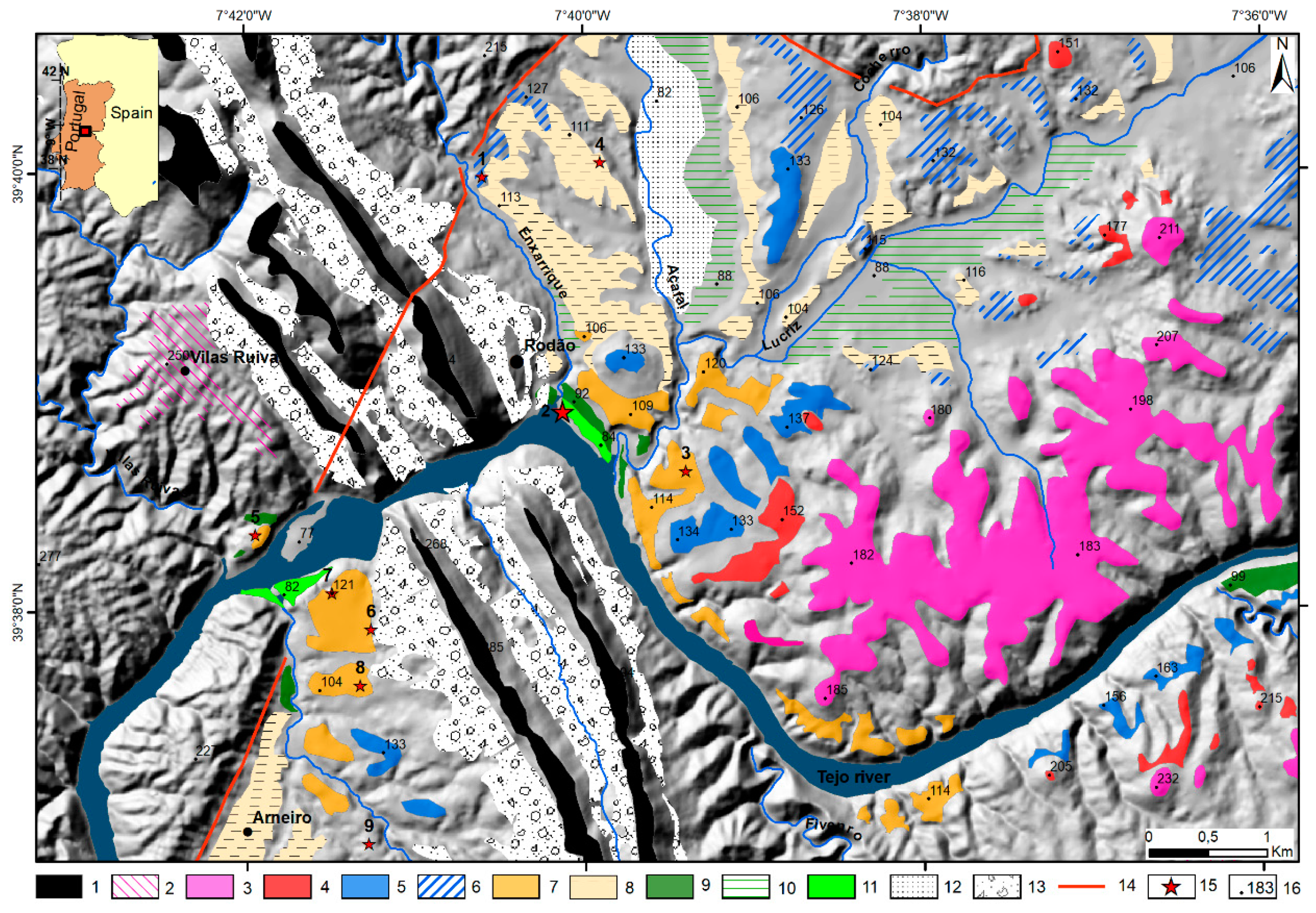
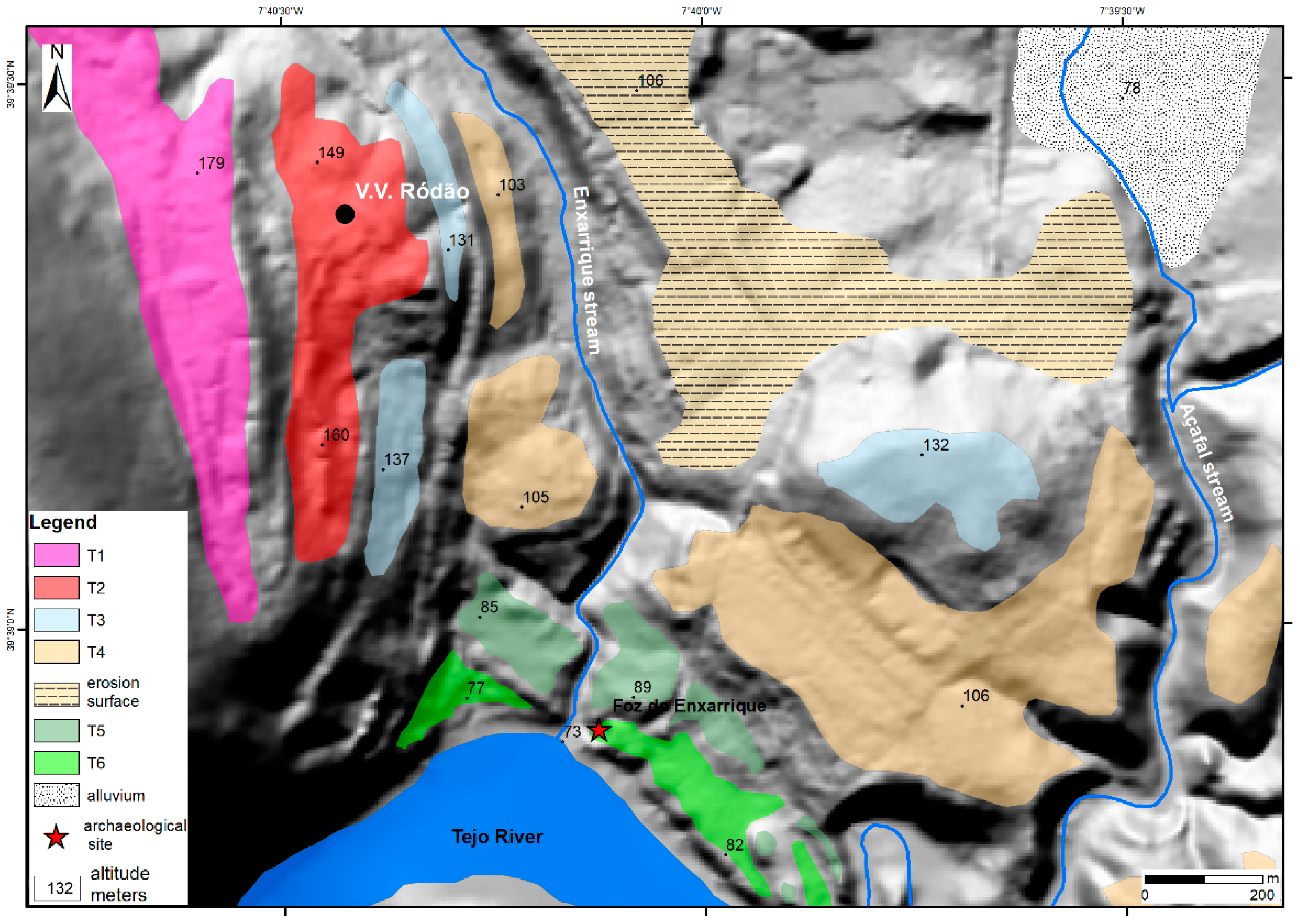
2. Geological and Geomorphological Setting
3. Methods
3.1. Geomorphological Mapping
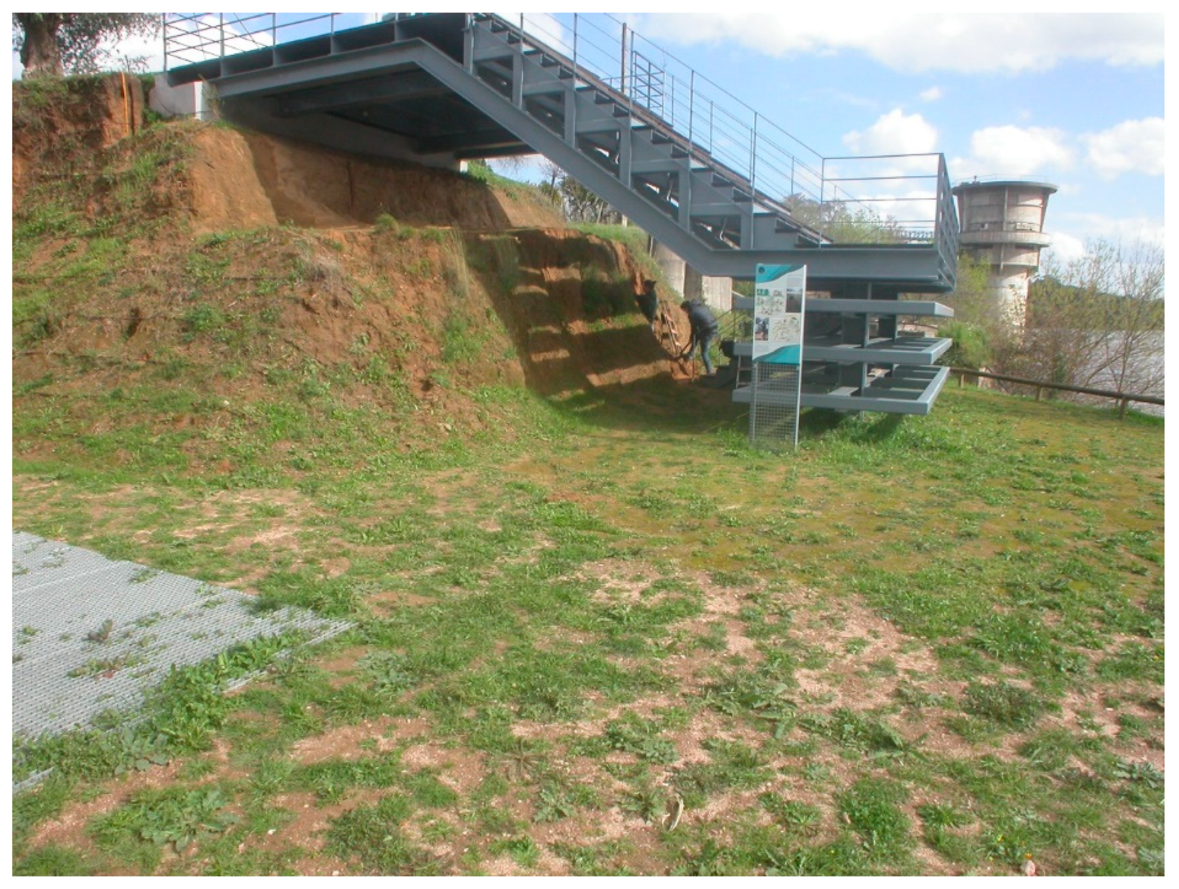
3.2. Field Work
3.3. Optically Stimulated Luminescence Dating
3.4. Grain-Size Measurements
3.5. Mineral Composition
3.6. Rock Magnetism
3.7. Phytoliths
3.8. Palynology
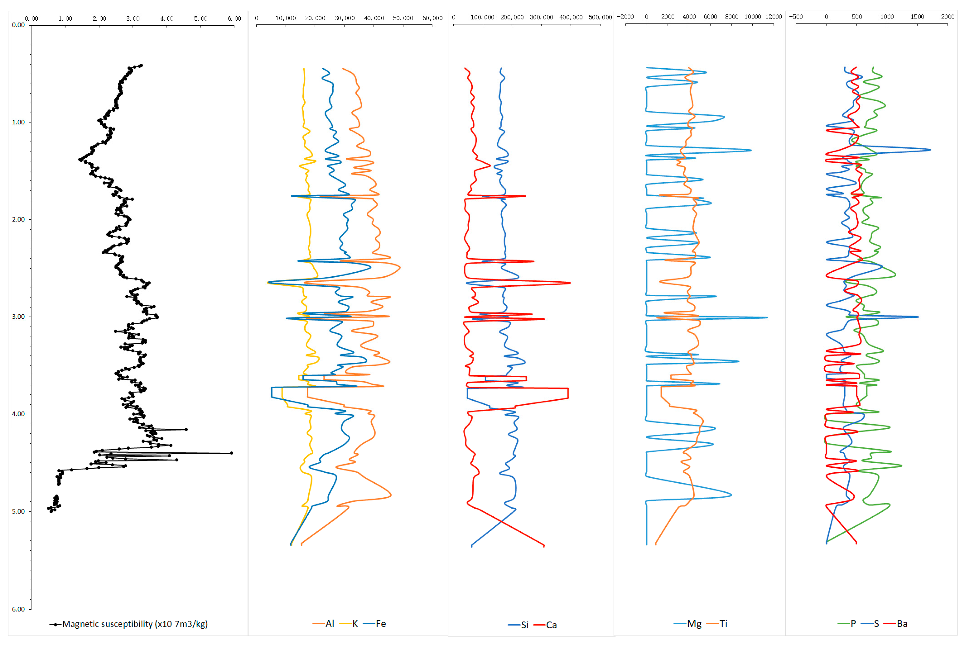
3.9. Geochemical Analyses
4. Results
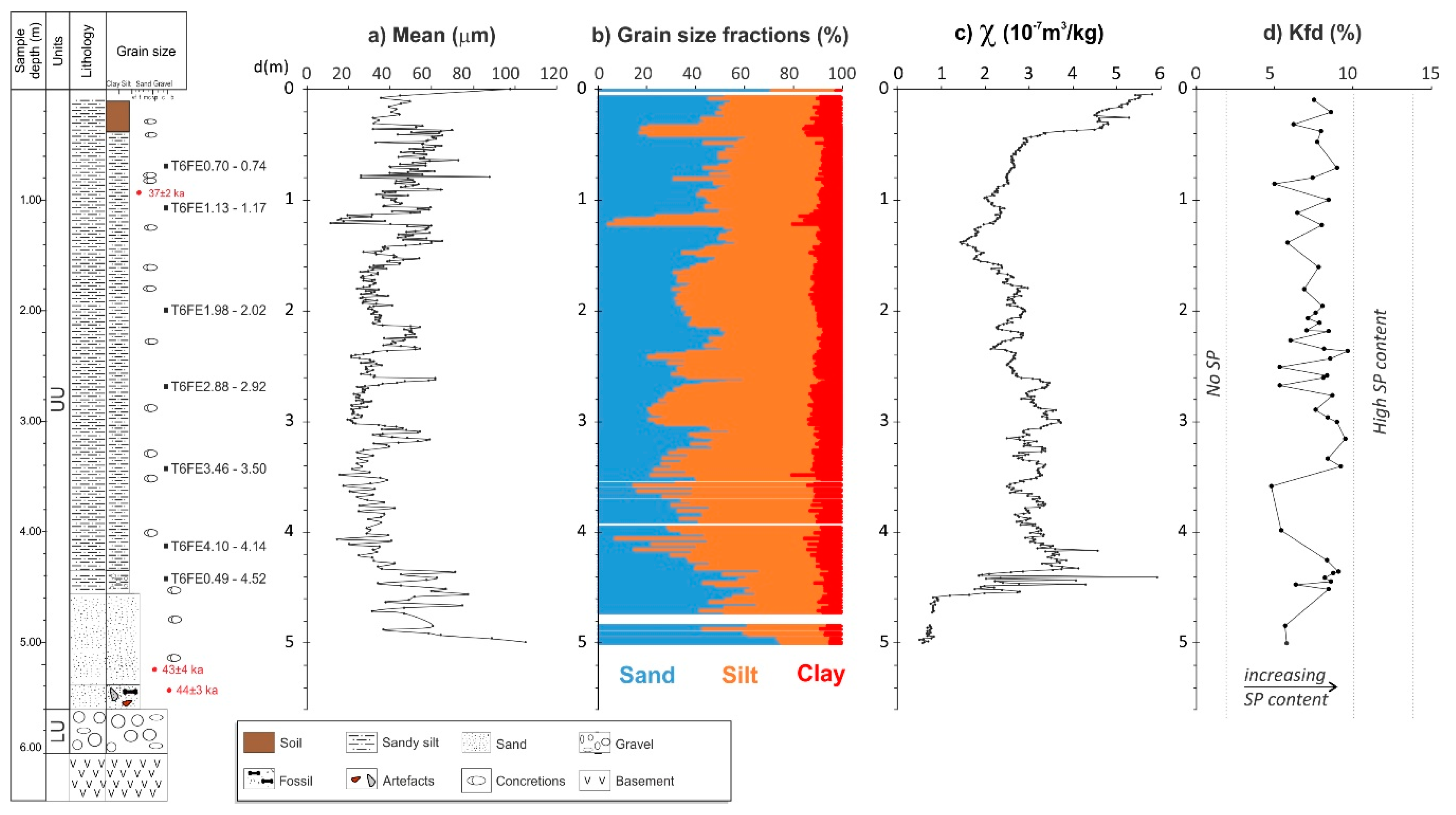
4.1. Geomorphology, Lithostratigraphy and Sedimentology
4.2. Luminescence Dating Results
4.3. Sediment Characterization of T6
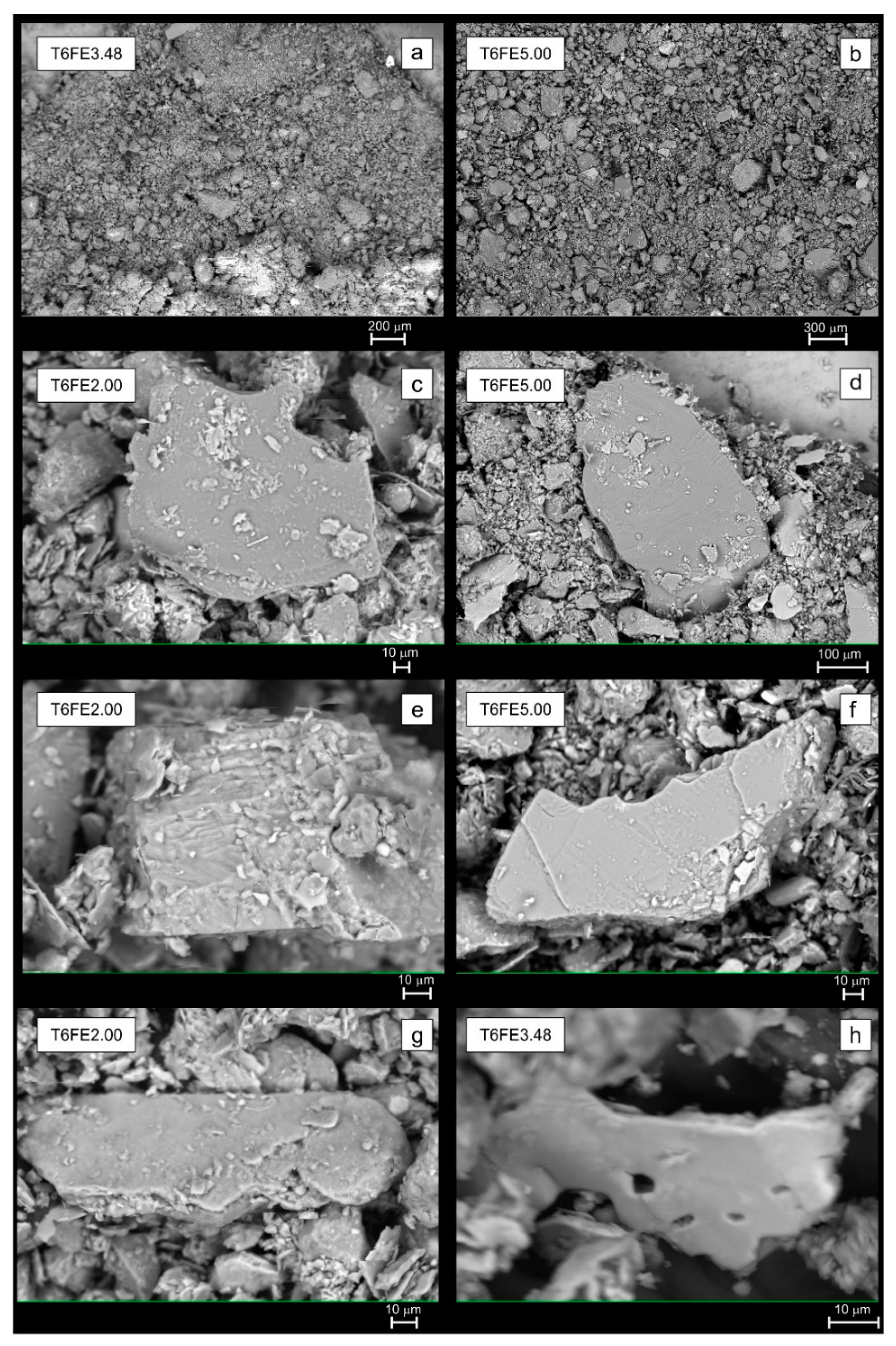
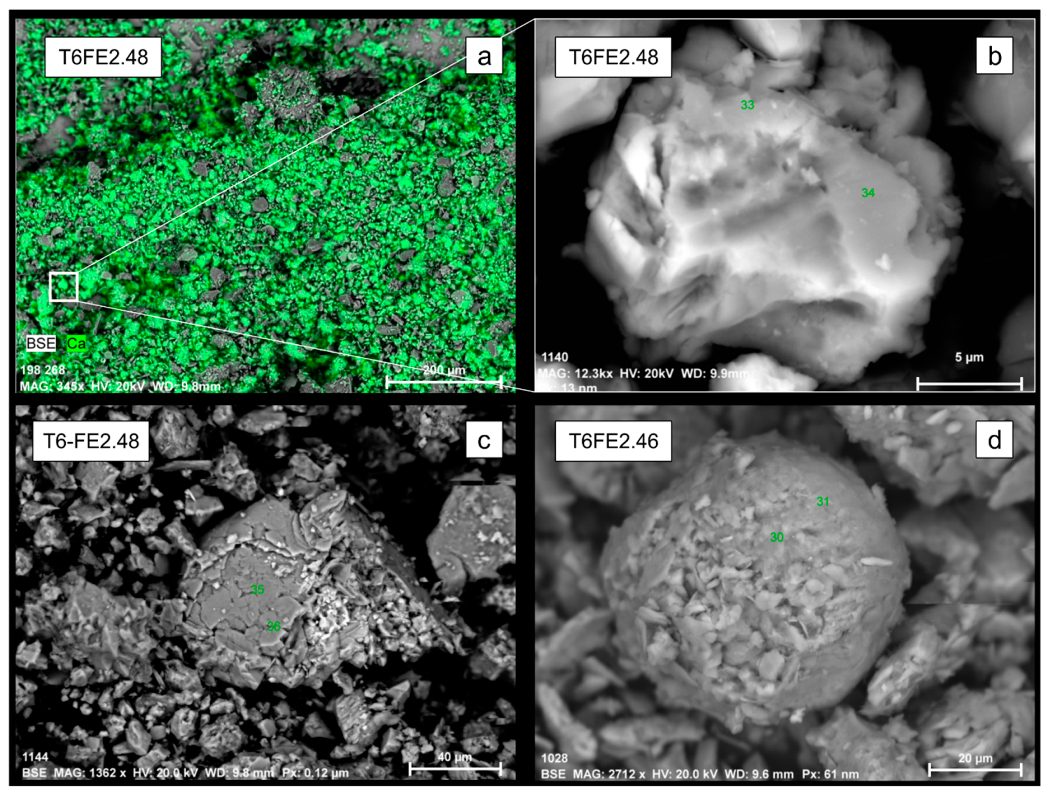
4.3.1. Mineral Composition
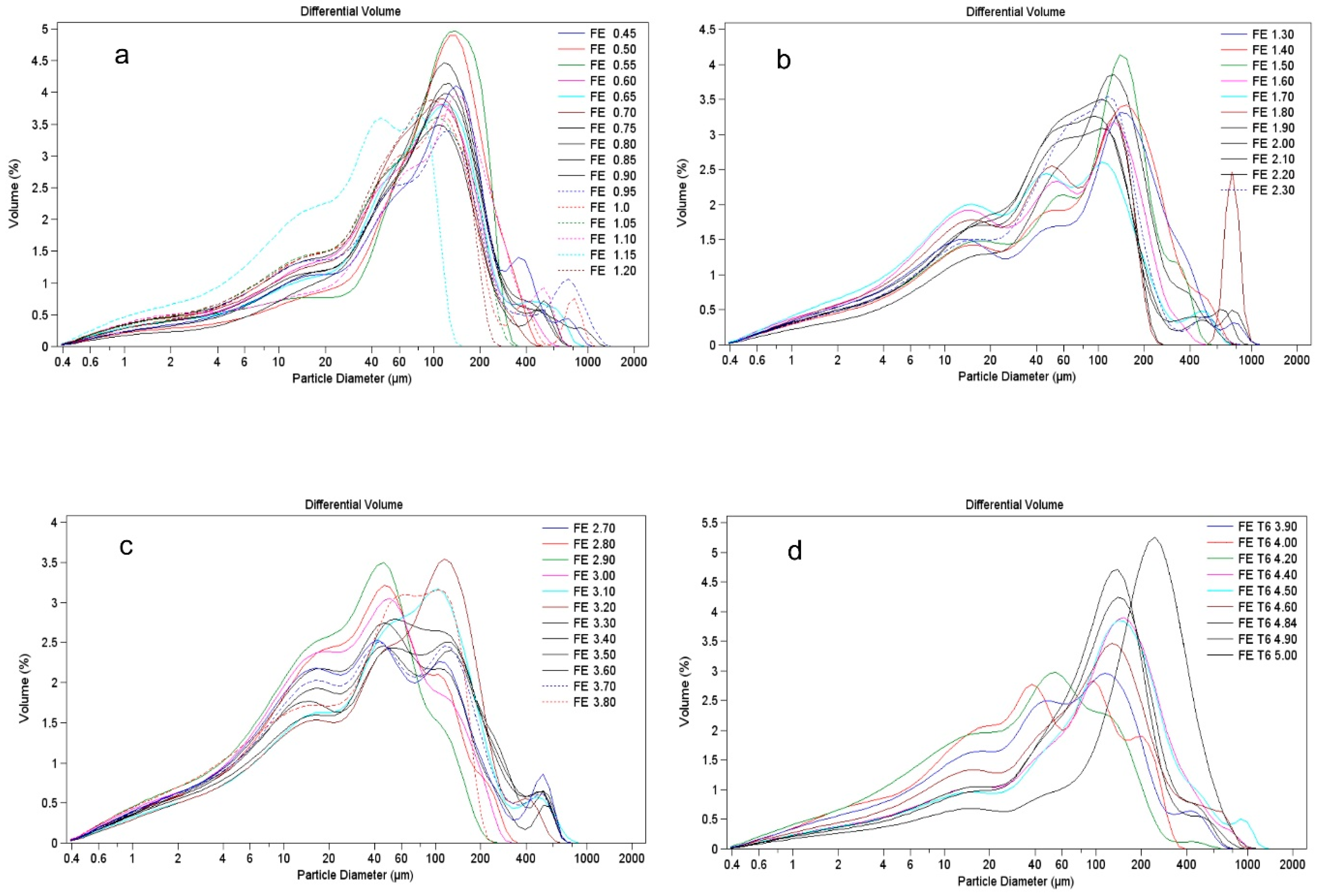
4.3.2. Grain-Size Analysis
4.3.3. Rock Magnetism
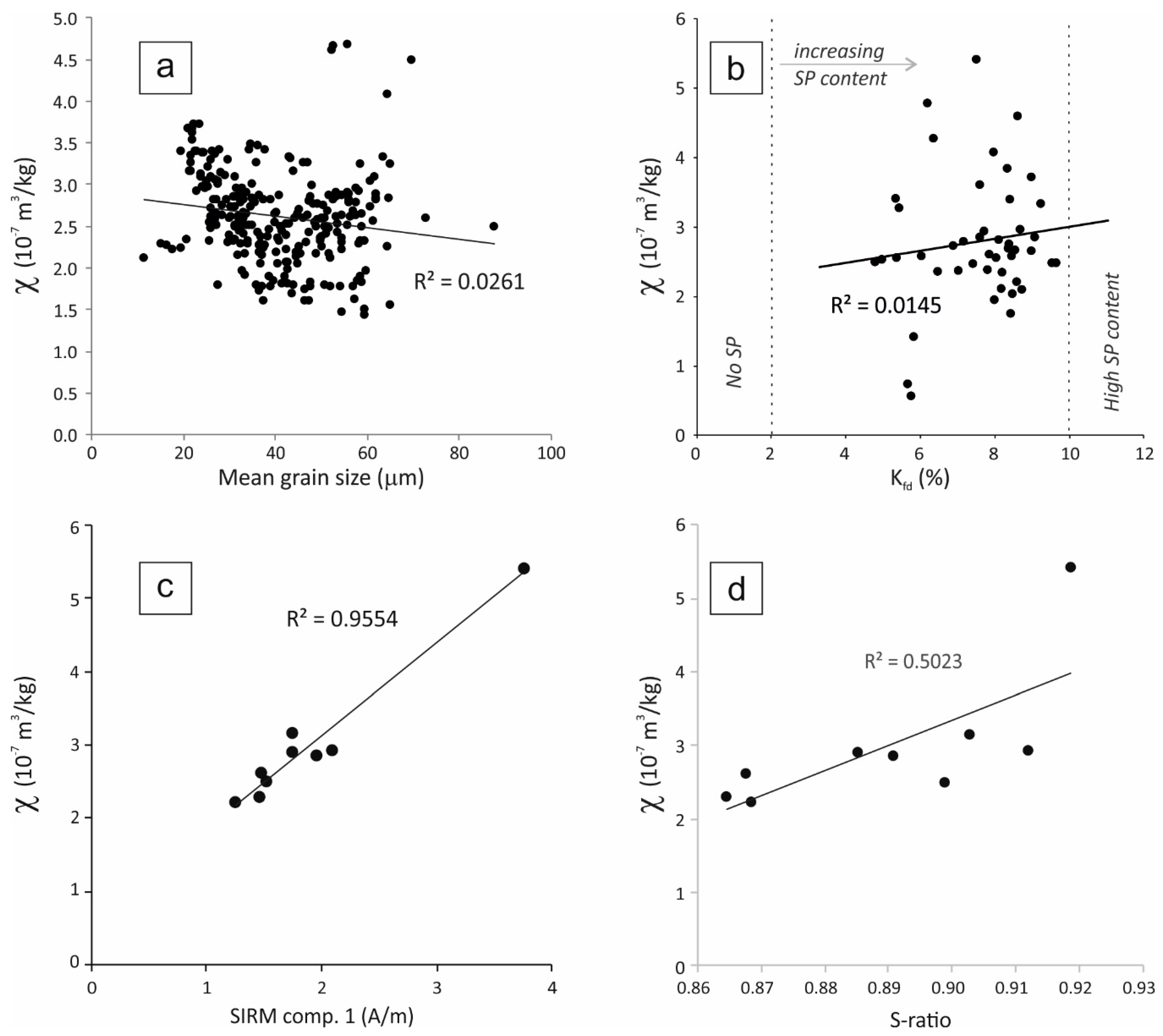
Magnetic Susceptibility
Frequency-Dependence Magnetic Susceptibility
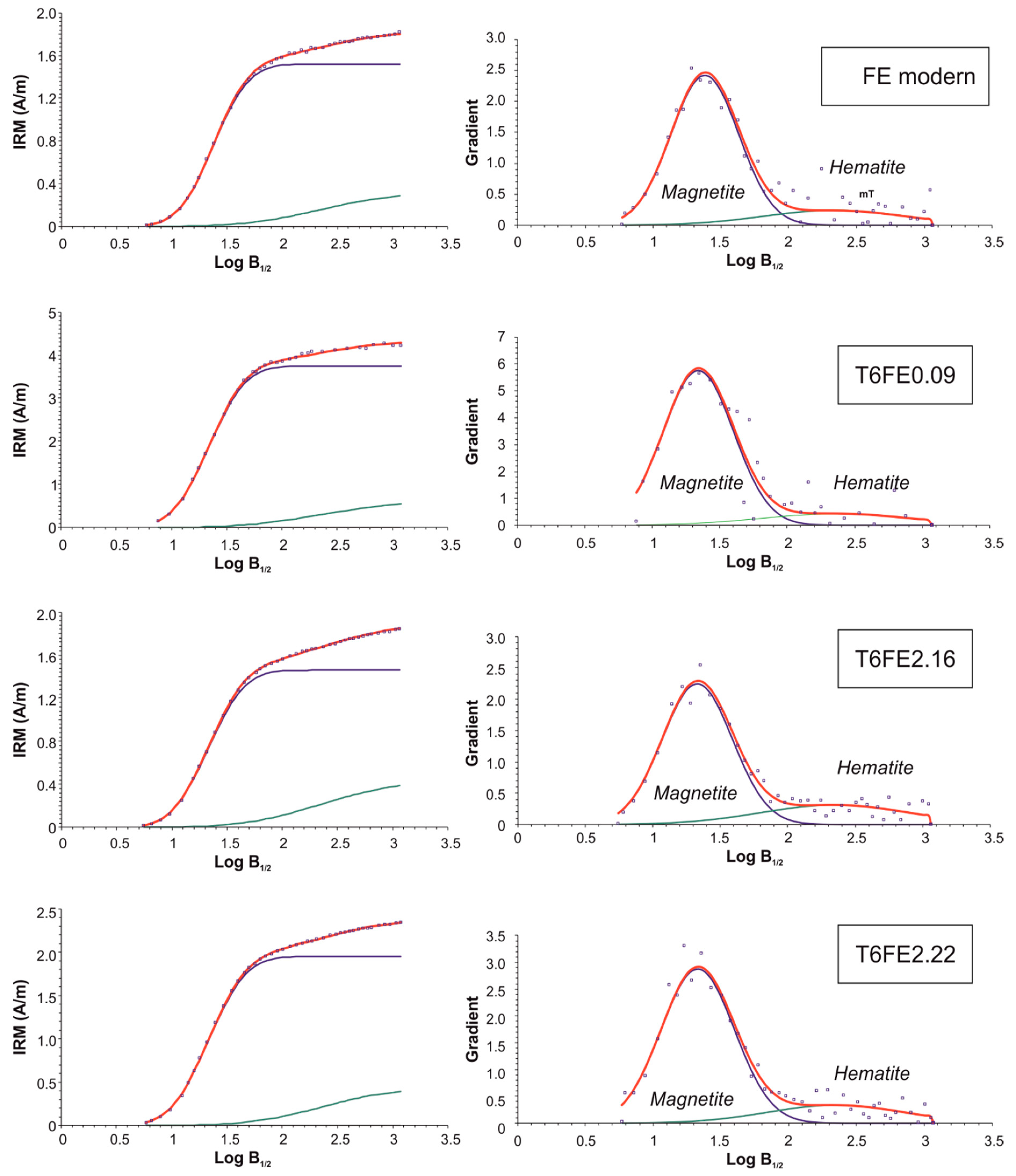
Isothermal Remanent Magnetization Curves
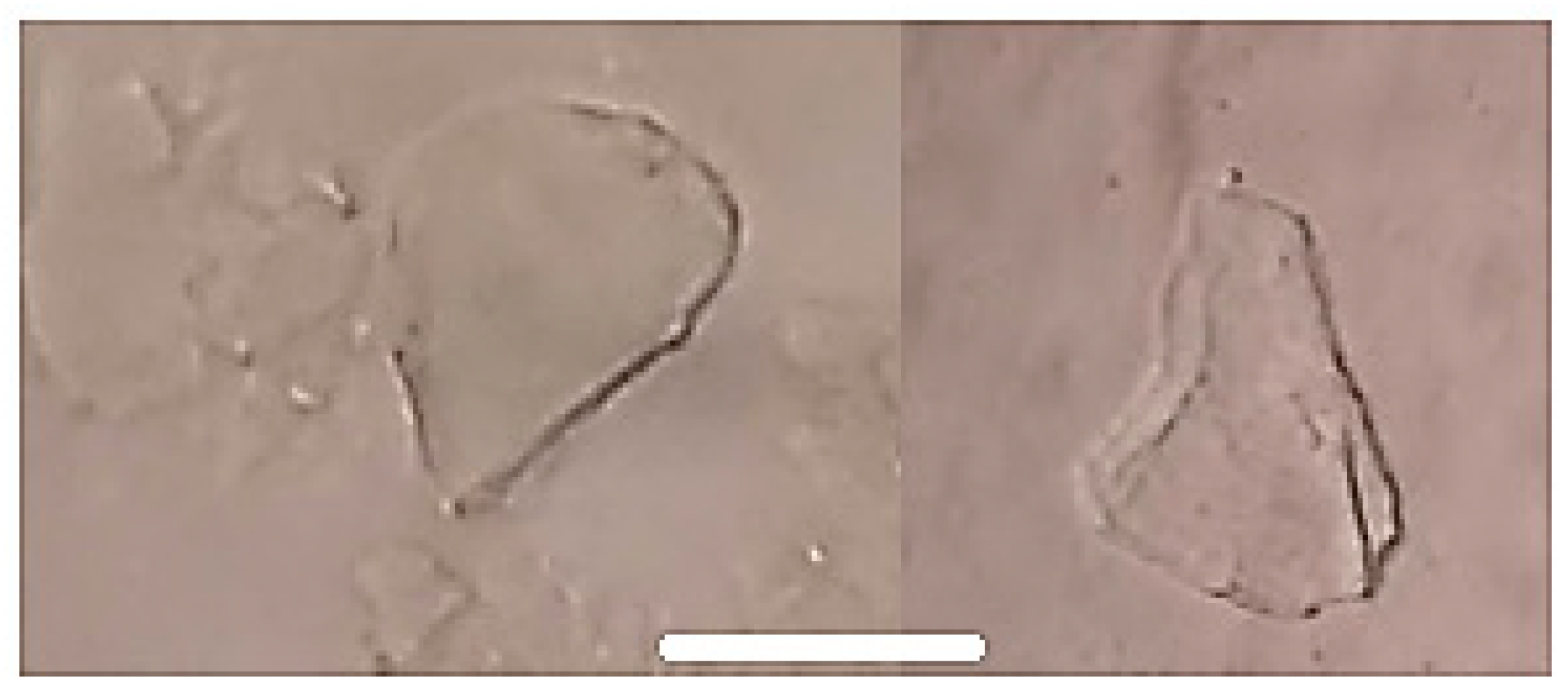
4.3.4. Phytolith Analysis
4.3.5. Palynology
4.3.6. Geochemical Analyses
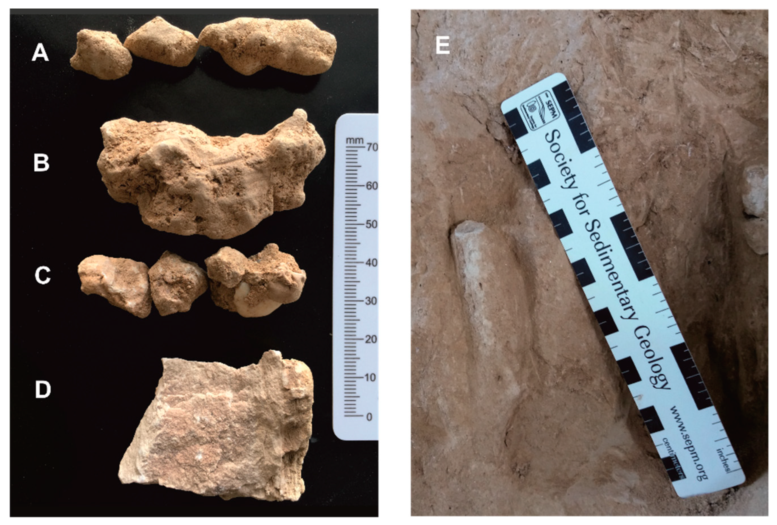
4.4. Palaeolithic Sites and Fauna Associated
5. Discussion
6. Conclusions
Supplementary Materials
Author Contributions
Funding
Acknowledgments
Conflicts of Interest
Appendix A

References
- Cunha, P.P.; Martins, A.A.; Daveau, S.; Friend, P.F. Tectonic control of the Tejo river fluvial incision during the late Cenozoic, in Ródão—Central Portugal (Atlantic Iberian border). Geomorphology 2005, 64, 271–298. [Google Scholar] [CrossRef]
- Cunha, P.P.; Almeida, N.A.C.; Aubry, T.; Martins, A.A.; Murray, A.S.; Buylaert, J.-P.; Sohbati, R.; Raposo, L.; Rocha, L. Records of human occupation from Pleistocene river terrace and aeolian sediments in the Arneiro depression (Lower Tejo River, central eastern Portugal). Geomorphology 2012, 165–166, 78–90. [Google Scholar] [CrossRef]
- Zilhão, J. Le passage du Paléolithique moyen/Paléolithique supérieur dans le Portugal. In El Origin Del Hombre Moderno En El Suroeste de Europ; UNED: Madrid, Spain, 1993; pp. 127–146. [Google Scholar]
- Zilhão, J. The Ebro Frontier: A Model for the Late Extinction of Iberian Neanderthals. In Neanderthals on the Edge: 150th Anniversary Conference of the Forbes’ Quarry Discovery, Gibraltar; Oxbow Books Limited: Oxford, UK, 2000; pp. 111–121. [Google Scholar]
- Zilhão, J. Chronostratigraphy of the Middle-to-Upper Paleolithic Transition in the Iberian Peninsula. Pyrenae 2006, 37, 7–84. [Google Scholar] [CrossRef]
- Zilhão, J. The Ebro frontier revisited. In The Mediterranean from 50,000 to 25,000 BP: Turning Points and New Directions; Camps, M., Szmidt, C., Eds.; Oxbow Books: Oxford, UK, 2009; pp. 293–311. [Google Scholar]
- Jöris, O.; Álvarez Fernández, E.; Weninger, B. Radiocarbon evidence of the Middle to Upper Palaeolithic transition in Southwestern Europe. Trab. Prehist. 2003, 60, 15–38. [Google Scholar] [CrossRef]
- Finlayson, C.; Giles Pacheco, F.; Rodríguez-Vidal, J.; Fa, D.A.; María Gutierrez López, J.; Santiago Pérez, A.; Finlayson, G.; Allue, E.; Baena Preysler, J.; Cáceres, I.; et al. Late survival of Neanderthals at the southernmost extreme of Europe. Nature 2006, 443, 850–853. [Google Scholar] [CrossRef] [PubMed]
- Finlayson, C.; Fa, D.A.; Jiménez Espejo, F.; Carrión, J.S.; Finlayson, G.; Giles Pacheco, F.; Rodríguez Vidal, J.; Stringer, C.; Martínez Ruiz, F. Gorham’s Cave, Gibraltar—The persistence of a Neanderthal population. Quat. Int. 2008, 181, 64–71. [Google Scholar] [CrossRef]
- Zilhão, J.; Davis, S.J.M.; Duarte, C.; Soares, A.M.M.; Steier, P.; Wild, E. Pego do Diabo (Loures, Portugal): Dating the emergence of anatomical modernity in westernmost Eurasia. PLoS ONE 2010, 5, e8880. [Google Scholar] [CrossRef]
- Zilhão, J.; Anesin, D.; Aubry, T.; Badal, E.; Cabanes, D.; Kehl, M.; Klasen, N.; Lucena, A.; Martín-Lerma, I.; Martínez, S.; et al. Precise dating of the Middle-to-Upper Paleolithic transition in Murcia (Spain) supports late Neandertal persistence in Iberia. Heliyon 2017, 3, e00435. [Google Scholar] [CrossRef]
- Bradtmöller, M.; Pastoors, A.; Weninger, B.; Weniger, G.-C.C. The repeated replacement model—Rapid climate change and population dynamics in Late Pleistocene Europe. Quat. Int. 2012, 247, 38–49. [Google Scholar] [CrossRef]
- De la Peña, P. The beginning of the Upper Paleolithic in the Baetic Mountain area (Spain). Quat. Int. 2013, 318, 69–89. [Google Scholar] [CrossRef]
- Galván, B.; Hernández, C.M.; Mallol, C.; Mercier, N.; Sistiaga, A.; Soler, V. New evidence of early Neanderthal disappearance in the Iberian Peninsula. J. Hum. Evol. 2014, 75, 16–27. [Google Scholar] [CrossRef] [PubMed]
- Bicho, N.; Marreiros, J.; Cascalheira, J.; Pereira, T.; Haws, J. Bayesian modeling and the chronology of the Portuguese Gravettian. Quat. Int. 2015, 359–360, 499–509. [Google Scholar] [CrossRef]
- Santonja, M.; Pérez-González, A. La industria lítica del miembro estratigráfico medio de Ambrona (Soria, España) en el contexto del Paleolítico Antiguo de la Península Ibérica. Zephyrvs 2006, 59, 7–20. [Google Scholar]
- Terradillos-Bernal, M.; Díez-Fernández-Lomana, J.C. La transition entre les Modes 2 et 3 en Europe: Le rapport sur les gisements du Plateau Nord (Péninsule Ibérique). Anthropologie 2012, 116, 348–363. [Google Scholar] [CrossRef]
- Ollé, A.; Mosquera, M.; Rodríguez, X.P.; de Lombera-Hermida, A.; García-Antón, M.D.; García-Medrano, P.; Peña, L.; Menéndez, L.; Navazo, M.; Terradillos, M.; et al. The Early and Middle Pleistocene technological record from Sierra de Atapuerca (Burgos, Spain). Quat. Int. 2013, 295, 138–167. [Google Scholar] [CrossRef]
- Álvarez-Alonso, D. First Neanderthal settlements in northern Iberia: The acheulean and the emergence of mousterian technology in the Cantabrian region. Quat. Int. 2014, 326–327, 288–306. [Google Scholar] [CrossRef]
- Santonja, M.; Pérez-González, A.; Panera, J.; Rubio-Jara, S.; Méndez-Quintas, E. The coexistence of Acheulean and Ancient Middle Palaeolithic techno-complexes in the Middle Pleistocene of the Iberian Peninsula. Quat. Int. 2016, 411, 367–377. [Google Scholar] [CrossRef]
- Daura, J.; Sanz, M.; Arsuaga, J.L.; Hoffmann, D.L.; Quam, R.M.; Ortega, M.C.; Santos, E.; Gómez, S.; Rubio, Á.; Villaescusa, L.; et al. New Middle Pleistocene hominin cranium from Gruta da Aroeira (Portugal). Proc. Natl. Acad. Sci. USA 2017, 114, 3397–3402. [Google Scholar] [CrossRef]
- Pereira, T.; Cunha, P.P.; Martins, A.A.; Nora, D.; Paixão, E.; Figueiredo, O.; Raposo, L.; Henriques, F.; Caninas, J.; Moura, D.; et al. Geoarchaeology of the Cobrinhos site (Vila Velha de Ródão, Portugal)—A record of the earliest Mousterian in western Iberia. J. Archaeol. Sci. Rep. 2019, in press. [Google Scholar]
- Cunha, P.P. Estratigrafia e Sedimentologia dos Depósitos do Cretácico Superior e Terciário de Portugal Central, a Leste de Coimbra/Stratigraphy and Sedimentology of the Upper Cretaceous and Tertiary of Central Portugal, East of Coimbra. Ph.D. Thesis, University of Coimbra, Coimbra, Portugal, July 1992; 262p. [Google Scholar]
- Cunha, P.P.; Barbosa, B.P.; Pena dos Reis, R. Synthesis of the Piacenzian onshore record, between the Aveiro and Setúbal parallels (Western Portuguese margin). Ciências da Terra 1993, 12, 35–43. [Google Scholar]
- Cunha, P.P. Unidades litostratigráficas do Terciário da Beira Baixa (Portugal). Comum. Inst. Geol. Min. 1996, 82, 87–130. [Google Scholar]
- Cunha, P.P.; Martins, A.A.; Huot, S.; Murray, A.S.; Raposo, L. Dating the Tejo River lower terraces in the Ródão area (Portugal) to assess the role of tectonics and uplift. Geomorphology 2008, 102, 43–54. [Google Scholar] [CrossRef]
- Cunha, P.P.; Martins, A.A.; Gouveia, M.P. As escadarias de terraços do Ródão à Chamusca (Baixo Tejo)—Caracterização e interpretação de dados sedimentares, tectónicos, climáticos e do Paleolítico/The terrace staircases of the Lower Tagus River (Ródão to Chamusca)—Characterization and interpretation of the sedimentary, tectonic, climatic and Palaeolithic data. Estudos do Quaternário 2016, 14, 1–24. [Google Scholar] [CrossRef]
- Cunha, P.P.; Martins, A.A.; Buylaert, J.P.; Murray, A.S.; Raposo, L.; Mozzi, P.; Stokes, M. New data on the chronology of the Vale do Forno sedimentary sequence (Lower Tejo River terrace staircase) and its relevance as a fluvial archive of the Middle Pleistocene in western Iberia. Quat. Sci. Rev. 2017, 166, 204–226. [Google Scholar] [CrossRef]
- Almeida, N.; Deprez, S.; De Dapper, M. The Palaeolithic occupation of the Northeastern of Alen Tagus (Portugal): A geoarchaeological approach. In Graphical Markers and Megalith Builders in the International Tagus, Iberian Peninsula—British Archaeological Reports International Series; Bueno-Ramirez, P., Barroso-Bermejo, R., Balbín Berhmann, R., Eds.; Archaeopress: Oxford, UK, 2008; Volume 1765, pp. 19–26. ISBN 9781407302546. [Google Scholar]
- Stokes, M.; Cunha, P.P.; Martins, A.A. Techniques for analysing Late Cenozoic river terrace sequences. Geomorphology 2012, 165–166, 1–6. [Google Scholar] [CrossRef]
- Duller, G.A.T. Luminescence dating of Quaternary sediments: Recent advances. J. Quat. Sci. 2004, 19, 183–192. [Google Scholar] [CrossRef]
- Murray, A.; Marten, R.; Johnston, A.; Martin, P. Analysis for naturally occurring radionuclides at environmental concentrations by gamma spectrometry. J. Radioanal. Nucl. Chem. 1987, 115, 263–288. [Google Scholar] [CrossRef]
- Olley, J.M.; Murray, A.S.; Roberts, R.G. The effects of disequilibria in the uranium and thorium decay chains on burial dose rates in fluvial sediments. Quat. Sci. Rev. 1996, 15, 751–760. [Google Scholar] [CrossRef]
- Huntley, D.J.; Baril, M.R. The K content of the K-feldspars being measured in optical dating or in thermoluminescence dating. Ancient TL 1997, 15, 11–13. [Google Scholar]
- Thomsen, K.J.; Murray, A.S.; Jain, M.; Bøtter-Jensen, L. Laboratory fading rates of various luminescence signals from feldspar-rich sediment extracts. Radiat. Meas. 2008, 43, 1474–1486. [Google Scholar] [CrossRef]
- Buylaert, J.-P.; Jain, M.; Murray, A.S.; Thomsen, K.J.; Thiel, C.; Sohbati, R. A robust feldspar luminescence dating method for Middle and Late Pleistocene sediments. Boreas 2012, 41, 435–451. [Google Scholar] [CrossRef]
- Kruiver, P.P.; Dekkers, M.J.; Heslop, D. Quantification of magnetic coercivity components by the analysis of acquisition curves of isothermal remanent magnetisation. Earth Planet. Sci. Lett. 2001, 189, 269–276. [Google Scholar] [CrossRef]
- Costa, F.G.C.M.; Bove, C.P.; Arruda, R.; Philbrick, C.T. Silica bodies and their systematic implications at the subfamily level in Podostemaceae. Rodriguesia 2011, 62, 937–942. [Google Scholar] [CrossRef]
- Piperno, D.R. Phytoliths: A Comprehensive Guide for Archaeologists and Paleoecologists; Rowman Altamira Press: Oxford, UK, 2006; p. 238. ISBN 9780759103856. [Google Scholar]
- Twiss, P.C.; Suess, E.; Smith, R.M. Morphological classification of grass phytoliths. Soil Sci. Soc. Am. Proc. 1969, 33, 109–115. [Google Scholar] [CrossRef]
- Madella, M.; Alexandre, A.; Ball, T. International code for phytolith nomenclature 1.0. Ann. Bot. 2005, 96, 253–260. [Google Scholar] [CrossRef] [PubMed]
- Faegri, K.; Iversen, J. Textbook of Pollen Analysis, 4th ed.; Faegri, K., Kaland, P.E., Krzywinski, K., Eds.; John Wiley and Sons: Chichester, UK, 1989; ISBN 0 471 92178 5. [Google Scholar]
- Moore, P.D.; Webb, J.A.; Collinson, M.E. Pollen Analysis; Blackwell: Oxford, UK, 1991; 216p, ISBN 0632021764. [Google Scholar]
- Reille, M. Pollen et Spores d’Europe et d’ Afrique du Nord; Laboratoire de Botanique Historique et Palynologie: Marseille, France, 1992; 543p, ISBN 2-9507175-0-0. [Google Scholar]
- Reille, M. Pollen et Spores d’Europe et d’ Afrique du Nord; Supplement 1; Laboratoire de Botanique Historique et Palynologie: Marseille, France, 1995; ISBN 2950717519. [Google Scholar]
- Reille, M. Pollen et Spores d´Europe et d´Afrique du Nord; Laboratoire de Botanique Historique et Palynologie: Marseille, France, 1999; ISBN-10: 2950717535. [Google Scholar]
- Wintle, A.G.; Murray, A.S. A review of quartz optically stimulated luminescence characteristics and their relevance in single-aliquot regeneration dating protocols. Radiat. Meas. 2006, 41, 369–391. [Google Scholar] [CrossRef]
- Raposo, L. Ambientes, Territorios y Subsistencia en el Paleolítico Medio de Portugal. Complutum 1995, 6, 57–78. [Google Scholar]
- Thompson, R.; Oldfield, F. Environmental Magnetism; Allen and Unwin: London, UK, 1986; p. 227. [Google Scholar]
- Evans, M.E.; Heller, F. Environmental Magnetism: Principles and Applications of Enviromagnetics; Academic: San Diego, CA, USA, 2003; ISBN 9780080505787. [Google Scholar]
- Grygar, T.; Svetlik, I.; Lisa, L.; Koptikova, L.; Bajer, A.; Wray, D.S.; Ettler, V.; Mihaljevic, M.; Novakova, T.; Koubova, M.; et al. Geochemical tools for the stratigraphic correlation of floodplain deposits of the Morava River in Straznicke Pomoravi, Czech Republic from the last millennium. Catena 2010, 80, 106–121. [Google Scholar] [CrossRef]
- Desenfant, F.; Petrovsky, E.; Rochette, P. Magnetic signature of industrial pollution of stream sediments and correlation with heavy metals: Case study from South France. Water Air Soil Pollut. 2004, 152, 297–312. [Google Scholar] [CrossRef]
- Zhang, C.X.; Appel, E.; Qiao, Q.Q. Heavy metal pollution in farmland irrigated with river water near a steel plant-magnetic and geochemical signature. Geophys. J. Int. 2013, 192, 963–974. [Google Scholar] [CrossRef]
- Maher, B.A.; Thompson, R. Pedogenesis and Paleoclimate—Interpretation of the Magnetic-Susceptibility Record of Chinese Loess-Paleosol Sequences—Comment. Geology 1994, 22, 857–858. [Google Scholar] [CrossRef]
- Maher, B.A.; Alekseev, A.; Alekseeva, T. Magnetic mineralogy of soils across the Russian Steppe: Climatic dependence of pedogenic magnetite formation. Palaeogeogr. Palaeoclimatol. Palaeoecol. 2003, 201, 321–341. [Google Scholar] [CrossRef]
- Egli, R. Characterization of Individual Rock Magnetic Components by Analysis of Remanence Curves, 1. Unmixing Natural Sediments. Studia Geophysica et Geodaetica 2004, 48, 391–446. [Google Scholar] [CrossRef]
- Cunha, P.P.; Cura, S.; Cunha Ribeiro, J.P.; Figueiredo, S.; Martins, A.A.; Raposo, L.; Pereira, T.; Almeida, N. As indústrias do Paleolítico Inferior e Médio associadas ao Terraço T4 do Baixo Tejo (Portugal central)—Arquivos da mais antiga ocupação humana no oeste da Ibéria, com ca. 340 ka a 155 ka/The Lower and Middle Palaeolithic industries associated with the T4 Terrace of the Lower Tejo River—Archives of the human occupation during ca. 335 ka to 155 ka ago. J. Lithic Stud. 2017, 4, 27–56. [Google Scholar] [CrossRef]
- Raposo, L. Os mais antigos vestígios de ocupação humana paleolítica na região de Ródão. In Da Pré-História, Homenagem a O. Veiga Ferreira; Editorial Delta: Madrid, Spain, 1987; pp. 153–178. [Google Scholar]
- Silva, A.; Pimenta, C.; Lemos, F.; Zilhão, J.; Mateus, J.; Raposo, L.; Coutinho, M. Vilas Ruivas: Um acampamento do Paleolítico Médio. História e Sociedade 1980, 7, 29–33. [Google Scholar]
- Raposo, L.; Silva, A.C. A estação Paleolítica de Vilas Ruivas (Ródão). Campanha de 1979. O Arqueólogo Português 1993, IV, 15–38. [Google Scholar]
- Almeida, N.A.C. Estruturas de habitat do final do Plistocénico médio em Portugal: O caso dos Pegos do Tejo 2, Portas de Ródão, Nisa. In Arqueologia Em Portugal—150 Anos; Associação dos Arqueólogos Portugueses: Lisboa, Portugal, 2013; pp. 243–250. [Google Scholar]
- Almeida, N.A.C. O Paleolítico Médio das Portas de Ródão, a Margem Esquerda (Nisa, Portugal). Contributo para a sua Caracterização Cronoestratigráfica. Ph.D Thesis, Universidade de Évora, Évora, Portugal, January 2014. [Google Scholar]
- Monteiro, M.; Henriques, F.; Clélia, S.; Évora, M.; Nora, D.; Alves, C.; Mendes, C.; Carvalho, E.; Anacleto, C.; Silva, D.; et al. Monte da Revelada 2—Resultados preliminares. AÇAFA On-line 2017, 11, 18–27. [Google Scholar]
- Raposo, L. Campanha de Escavações Arqueológicas no Sítio da Foz do Enxarrique. Alto Tejo. Boletim Informativo do Núcleo Regional de Investigação Arqueológica 1991, 9, 1–2. [Google Scholar]
- Cardoso, J.L. Contribuição para o conhecimento dos grandes mamíferos do Plistocénico Superior de Portugal; Câmara Municipal de Oeiras: Oeiras, Portugal, 1993. [Google Scholar]
- Brugal, J.-P.; Raposo, L. Foz do Enxarrique (Ródão—Portugal): Preliminary results of the analysis of a bone assemblage from A Midle Palaeolithic open site. In The Role of Early Humans in the Accumulation of European Lower and Middle Palaeolithic Bone Assemblages; Römisch Germanisches Zentralmuseum Mainz: Mainz, Germany, 1999; pp. 367–379. ISBN 9783884670446. [Google Scholar]
- Sousa, M.F.; Figueiredo, S.D. The Pleistocene Elephants of Portugal. In Proceedings of the Congresso La Terra degli Elefanti (Actas), Roma, Italy, 16–20 October 2001; pp. 611–616. [Google Scholar]
- Figueiredo, S.D.; Sousa, M.F. Os Elefantes Pleistocénicos de Portugal. Revista Evolução 2003, 1, 3–32. [Google Scholar]
- Figueiredo, S.D.; Raposo, L. As Aves Como Recurso Alimentar do Homem do Paleolítico Médio: Interpretação tafonómica das acumulações faunísticas da Gruta Nova da Columbeira e da Foz do Enxarrique. Boletim do Centro Português de Geo-História e Pré-História 2018, 4, 69–82. [Google Scholar]
- Berruti, G.L.F.; Rosina, P.; Raposo, L. The use-wear analysis of the quartzite lithic assemblage from the middle Palaeolithic site of Foz do Enxarrique (Ródão, Portugal). Mediterr. Archaeol. Archaeom. 2016, 16, 107–126. [Google Scholar] [CrossRef]
- Marín-Arroyo, A.B.; Rios-Garaizar, J.; Straus, L.G.; Jones, J.R.; de la Rasilla, M.; González Morales, M.R.; Richards, M.; Altuna, J.; Mariezkurrena, K.; Ocio, D. Chronological reassessment of the Middle to Upper Paleolithic transition and Early Upper Paleolithic cultures in Cantabrian Spain. PLoS ONE 2018, 13, e0194708. [Google Scholar] [CrossRef]
- Zilhão, J. Middle Paleolithic settlement patterns in Portugal. In Settlement Dynamics of the Middle Paleolithic and Middle Stone Age; Conard, N., Ed.; Kerns Verlag: Tübingen, Germany, 2001; pp. 597–608. [Google Scholar]
- Cardoso, J.L. The Mousterian complex in Portugal. Zephyrus 2006, 59, 21–50. [Google Scholar]
- Benedetti, M.M.; Haws, J.A.; Funk, C.L.; Daniels, J.M.; Hesp, P.A.; Bicho, N.F.; Minckley, T.A.; Ellwood, B.B.; Forman, S.L. Late Pleistocene raised beaches of coastal Estremadura, central Portugal. Quat. Sci. Rev. 2009, 28, 3428–3447. [Google Scholar] [CrossRef]
- Pereira, T.; Bicho, N.; Haws, J. O Paleolítico Médio em Território Português. Mainake 2012, 33, 11–30. [Google Scholar]
- Martignier, L.; Nussbaumer, M.; Adatte, T.; Gobat, J.M.; Verrecchia, E.P. Assessment of a locally—Sourced loess system in Europe: The Swiss Jura Mountains. Aeolian Res. 2015, 18, 11–21. [Google Scholar] [CrossRef]
- Újvári, G.; Kok, J.F.; Varga, G.; Kovács, J. The physics of wind-blown loess: Implications for grain size proxy interpretations in Quaternary paleoclimate studies. Earth-Sci. Rev. 2016, 154, 247–278. [Google Scholar] [CrossRef]
- Vandenberghe, J.; Sun, Y.; Wang, X.; Abels, H.A.; Liu, X. Grain-size characterization of reworked fine-grained aeolian deposits. Earth-Sci. Rev. 2018, 177, 43–52. [Google Scholar] [CrossRef]
- Varga, G.; Újvári, G.; Kovács, J. Interpretation of sedimentary (sub)populations extracted from grain size distributions of Central European loess-paleosol series. Quat. Int. 2017. [Google Scholar] [CrossRef]
- Wolf, D.; Ryborz, K.; Kolb, T.; Calvo Zapata, R.; Sanchez Vizcaino, J.; Zöller, L.; Faust, D. Origins and genesis of loess deposits in central Spain, as indicated by heavy mineral compositions and grain-size variability. Sedimentology 2018, in press. [Google Scholar] [CrossRef]
- Kravchinsky, V.A.; Langereis, C.G.; Walker, S.D.; Dlusskiy, K.G.; White, D. Discovery of Holocene millennial climate cycles in the Asian continental interior: Has the sun been governing the continental climate? Glob. Planet. Chang. 2013, 110, 386–396. [Google Scholar] [CrossRef]
- Liu, Q.S.; Deng, C.L.; Yu, Y.J.; Torrent, J.; Jackson, M.J.; Banerjee, S.K.; Zhu, R.X. Temperature dependence of magnetic susceptibility in an argon environment: Implications for pedogenesis of Chinese loess/palaeosols. Geophys. J. Int. 2005, 161, 102–112. [Google Scholar] [CrossRef]
- Maher, B.A. The magnetic properties of Quaternary aeolian dusts and sediments, and their palaeoclimatic significance. Aeolian Res. 2011, 3, 87–144. [Google Scholar] [CrossRef]
- Shi, L.F.; Yang, Z.Y.; Zheng, L.D.; Jia, S.M.; Tong, Y.B.; Zhang, S.Q.; Xu, D.Y.; Guo, G.X. Environmental magnetic record of the fluvial sediments from the Tianzhu borehole in Beijing for the last 800 ka. Earth Planets Space 2010, 62, 631–645. [Google Scholar] [CrossRef]
- Lu, H.Y.; Van Huissteden, K.O.; An, Z.S.; Nugteren, G.; Vandenberghe, J. East Asia winter monsoon variations on a millennial time-scale before the last glacial-interglacial cycle. J. Quat. Sci. 1999, 14, 101–110. [Google Scholar] [CrossRef]
- Maher, B.A.; Thompson, R. Paleoclimatic significance of the mineral magnetic record of the Chinese loess and paleosols. Quat. Res. 1992, 37, 155–170. [Google Scholar] [CrossRef]
- Maher, B.A. Environmental magnetism and climate change. Contemp. Phys. 2007, 48, 247–274. [Google Scholar] [CrossRef]
- Sánchez Goñi, M.F.; Eynaud, F.; Turon, J.L.; Shackleton, N.J. High resolution palynological record off the Iberian Margin: Direct land-sea correlation for the Last Interglacial complex. Earth Planet. Sci. Lett. 1999, 171, 123–137. [Google Scholar] [CrossRef]
- Sánchez Goñi, M.F.; Turon, J.-L.; Eynaud, F.; Gendreau, S. European climatic response to millennial-scale changes in the atmosphere-ocean system during the last glacial period. Quat. Res. 2000, 54, 394–403. [Google Scholar] [CrossRef]
- Sánchez Goñi, M.F.; Cacho, I.; Turon, J.-L.; Guiot, J.; Sierro, F.J.; Peypouquet, J.-P.; Grimalt, J.O.; Shackleton, N.J. Synchroneity between marine and terrestrial responses to millennial scale climatic variability during the last glacial period in the Mediterranean region. Climate Dyn. 2002, 19, 95–105. [Google Scholar] [CrossRef]
- Roucoux, K.H.; Shackleton, N.J.; de Abreu, L.; Schõnfeld, J.; Tzedakis, P.C. Combined marine proxy and pollen analyses reveal rapid Iberian vegetation response to North Atlantic millennial-scale climate oscillations. Quat. Res. 2001, 56, 128–132. [Google Scholar] [CrossRef]
- Roucoux, K.H.; de Abreu, L.; Shackleton, N.J.; Tzedakis, P.C. The response of NW Iberian vegetation to North Atlantic climate oscillations during the last 65 kyr. Quat. Sci. Rev. 2005, 24, 1637–1653. [Google Scholar] [CrossRef]
- De Abreu, L.; Shackleton, N.J.; Schõnfeld, J.; Hall, M.; Chapman, M.R. Millennial-scale oceanic climate variability off the Western Iberian margin during the last two glacial periods. Mar. Geol. 2003, 196, 1–20. [Google Scholar] [CrossRef]
- Schönfeld, J.; Zahn, R.; de Abreu, L. Surface to deep water response to rapid climate changes at the western Iberian Margin. Glob. Planet. Chang. 2003, 36, 237–264. [Google Scholar] [CrossRef]
- Dansgaard, W.; Johnsen, S.J.; Clauser, H.B.; Dahl, J.; Gundestrup, N.S.; Hommer, C.U.; Huidberg, C.S.; Steffensen, J.P.; Svernbjornsdottir, A.E.; Jouzel, J.; et al. Evidence for general instability of past climate from a 250 kyr ice-core record. Nature 1993, 364, 218–220. [Google Scholar] [CrossRef]
- Grootes, P.M.; Stuiver, M.; White, J.W.C.; Johnsen, S.; Jouzel, J. Comparison of oxygen isotope records from the GISP2 and GRIP Greenland ice cores. Nature 1993, 366, 552–554. [Google Scholar] [CrossRef]
- Ruiz Zapata, M.B.; Rodríguez de Tembleque, J.M.; Pérez González, A.; Gil García, M.J. Paleovegetación en el yacimiento achelense de Puente Pino y su entorno (Toledo, España). Cuaternario y Geomorfología 2009, 23, 113–126. [Google Scholar]


| NLL and Field Codes | X-Y Coordinates | U-238 (Bq kg−1) | Ra-226 (Bq kg−1) | Th-232 (Bq kg−1) | K-40 (Bq kg−1) | Water Content (%) |
|---|---|---|---|---|---|---|
| 052201 PC1 | 39°58′59″ N 7°40′13″ W | 108 ± 6 | 109.2 ± 1.4 | 191.4 ± 2.0 | 784 ± 19 | 10 |
| 052202 PC2 | 39°58′59″ N 7°40′13″ W | 89 ± 6 | 77.4 ± 0.8 | 98.4 ± 0.9 | 727 ± 10 | 10 |
| 052204 PC4 | 39°58′59″ N 7°40′13″ W | 52 ± 3 | 52.3 ± 0.5 | 75.5 ± 0.7 | 715 ± 9 | 10 |
| 052207 PC8 | 39°38′29″ N 7°41′56″ W | 63 ± 11 | 70.3 ± 2.0 | 108.6 ± 2.1 | 621 ± 33 | 20 |
| 052208 PC9 | 39°39′19″ N 7°40′07″ W | 19 ± 6 | 27.6 ± 0.6 | 29.6 ± 0.6 | 902 ± 17 | 25 |
| 052231 VRU4 | 39°38′29″ N 7°41′56″ W | 78 ± 9 | 74.5 ± 1.0 | 114.3 ± 1.2 | 583 ± 12 | 20 |
| 052246 VRU5 | 39°38′29″ N 7°41′56″ W | 27 ± 4 | 23.1 ± 0.4 | 28.0 ± 0.5 | 843 ± 12 | 10 |
| 052247 ENXAR1 | 39°58′59″ N 7°40′13″ W | 44 ± 4 | 48.7 ± 0.5 | 75.1 ± 0.7 | 765 ± 8 | 10 |
| 052253 VRU3 | 39°38′29″ N 7°41′56″ W | 69 ± 7 | 61.3 ± 0.8 | 96.3 ± 1.1 | 536 ± 10 | 10 |
| 062201 ENXAR2 | 39°58′59″ N 7°40′13″ W | 64 ± 7 | 68.4 ± 0.9 | 92.0 ± 1.1 | 764 ± 14 | 10 |
| 062202 PARN1 | 39°38′11″ N 7°41′35″ W | 25 ± 5 | 27.9 ± 0.5 | 21.6 ± 0.5 | 843 ± 14 | 10 |
| 062203 PARN2 | 39°38′11″ N 7°41′35″ W | 18 ± 5 | 24.9 ± 0.5 | 27.1 ± 0.5 | 995 ± 12 | 10 |
| NLL and Field Code | Sampled Site | Terrace Unit | Depth (cm) | IR50, with Fading Corr. Age (ka) | pIRIR290 Age (ka) | pIRIR290 2*Do (Gy) | pIRIR290 De (Gy) | pIRIR290 Aliquots (n) | Dose Rate (Gy/ka) |
|---|---|---|---|---|---|---|---|---|---|
| 052201 PC1 | Foz de Enxarrique | T6, base middle part | 550 | 38.5 ± 1.5 | 44 ± 3 | 350 ± 14 | 12 | 7.94 ± 0.32 | |
| 052202 PC2 | Foz de Enxarrique | T6, lower middle part | 530 | 34.8 ± 1.3 | 43 ± 4 | 251 ± 21 | 9 | 5.83 ± 0.22 | |
| 052204 PC4 | Foz de Enxarrique | T5, middle part | 150 | 136 ± 10 | 135 ± 9 | 683 ± 34 | 12 | 5.05 ± 0.18 | |
| 052207 PC8 | Vilas Ruivas | T5, middle part | 400 | 105 ± 8 | 99 ± 7 | 507 ± 28 | 12 | 5.10 ± 0.19 | |
| 052208 PC9 | Rodense Bolaria | T4, lower part | 200 | 277 ± 17 | >220 | >835 ± 51 | 6 | 3.95 ± 0.13 | |
| 052231 VRU4 | Vilas Ruivas | T5, upper part | 400 | 71 ± 4 | 367 ± 17 | 9 | 5.18 ± 0.18 | ||
| 052246 VRU5 | Vilas Ruivas | T4, lower part | 300 | 277 ± 17 | >220 | >863 ± 13 | 6 | 4.19 ± 0.15 | |
| 052247 ENXAR1 | Foz de Enxarrique | T5, lower part | 200 | 125 ± 7 | 145 ± 10 | 741 ± 40 | 12 | 5.11 ± 0.19 | |
| 052253 VRU3 | Vilas Ruivas | T5, middle part | 400 | 113 ± 6 | 117 ± 7 | 587 ± 27 | 6 | 5.02 ± 0.19 | |
| 062201 ENXAR2 | Foz de Enxarrique | T6, topmost part | 90 | 31.6 ± 1.3 | 37 ± 2 | 212 ± 6 | 6 | 5.73 ± 0.22 | |
| 062202 PARN1 | Pegos do Tejo-2 (Arneiro) | T4, lower middle part | 400 | 209 ± 11 | >190 | >767 ± 27 | 9 | 4.14 ± 0.15 | |
| 062203 PARN2 | Pegos do Tejo-2 (Arneiro) | T4, lower top part | 300 | 129 ± 11 | >160 | >743 ± 31 | 8 | 4.62 ± 0.17 |
| Sample Code | Smectite (%) | Vermiculite (%) | Kaolinite (%) | Illite (%) | Chlorite (%) | Clay Mineral Association |
|---|---|---|---|---|---|---|
| T5FE0.15–0.23 T5FE0.92–1.00 | 54 53 | 0 0 | 25 18 | 21 29 | 0 0 | S k i S i k |
| T6FE0.70–0.74 T6FE1.13–1.17 | 48 52 | 0 0 | 26 23 | 26 25 | 0 0 | S k i S i k |
| T6FE1.97–2.02 T6FE2.88–2.92 T6FE3.46–3.50 T6FE4.10–4.14 T6FE4.49–4.52 T6FE4.98–5.02 FE modern | 41 47 35 42 46 45 17 | 0 0 16 0 0 0 14 | 27 31 25 24 24 20 22 | 32 22 24 34 30 35 35 | 0 0 0 0 0 0 12 | S i k S k i S k i v S i k S i k S i k I k s v c |
| Sample Code | Component 1 (Magnetite) | Component 2 (Hematite) | |||||||
|---|---|---|---|---|---|---|---|---|---|
| % | SIRM | B1/2 | DP | % | SIRM | B1/2 | DP | S-Ratio | |
| FE modern | 83.1 | 1.52 | 24.0 | 0.25 | 16.9 | 0.31 | 218.8 | 0.52 | 0.90 |
| T6FE0.09 | 86.2 | 3.75 | 21.9 | 0.26 | 13.8 | 0.60 | 223.9 | 0.55 | 0.92 |
| T6FE0.62 | 77.8 | 1.47 | 21.9 | 0.26 | 22.2 | 0.42 | 223.9 | 0.55 | 0.87 |
| T6FE2.00 | 80.6 | 1.75 | 21.9 | 0.3 | 19.4 | 0.42 | 223.9 | 0.55 | 0.89 |
| T6FE2.16 | 77.2 | 1.46 | 21.4 | 0.26 | 22.8 | 0.43 | 223.9 | 0.55 | 0.86 |
| T6FE2.22 | 82.3 | 1.95 | 21.4 | 0.27 | 17.7 | 0.42 | 223.9 | 0.50 | 0.89 |
| T6FE2.33 | 76.7 | 1.25 | 21.4 | 0.26 | 23.3 | 0.38 | 199.5 | 0.53 | 0.87 |
| T6FE3.74 | 84.3 | 2.09 | 22.4 | 0.25 | 15.7 | 0.39 | 199.5 | 0.53 | 0.91 |
| T6FE3.84 | 79.5 | 1.75 | 22.4 | 0.25 | 20.5 | 0.45 | 158.5 | 0.50 | 0.90 |
| Sample Code | Taxa | Count |
|---|---|---|
| Basal layer (archaeological strata) of the T6 upper unit | ||
| FE/15 0.25–0.30 | Indeterminate | 1 |
| FE/15 0.35–0.40 | Chenopodiaceae | 2 |
| Indeterminate | 4 | |
| FE/15 0.45–0.50 | Indeterminate | 2 |
| Upper part of the T6 upper unit (silty sands and sandy silts) | ||
| T6FE0.70–0.74 | Pinus sp. | 4 |
| Ericaceae | 2 | |
| Poaceae | 2 | |
| Artemisia | 1 | |
| Chenopodiaceae | 2 | |
| Indeterminable | 9 | |
| T6FE1.13–1.17 | Pinus sp. | 1 |
| Poaceae | 2 | |
| Indeterminate | 10 | |
| T6FE1.97–2.02 | Pinus sp. | 1 |
| Asteraceae tubuliflora | 1 | |
| Indeterminate | 6 | |
| T6FE2.88–2.92 | Indeterminate | 1 |
| T6FE3.46–3.50 | Indeterminate | 3 |
| T6FE4.10–4.14 | Indeterminate | 1 |
| T6FE4.49–4.52 | Indeterminate | 1 |
| T6FE4.98–5.02 | Pinus sp. | 1 |
| Indeterminate | 1 | |
| T5 lower part (sandy silts) | ||
| T5FE0.15–0.23 | Indeterminate e | 1 |
| T5FE0.92–1.00 | Pinus sp. | 1 |
| Indeterminate | 2 | |
© 2019 by the authors. Licensee MDPI, Basel, Switzerland. This article is an open access article distributed under the terms and conditions of the Creative Commons Attribution (CC BY) license (http://creativecommons.org/licenses/by/4.0/).
Share and Cite
Cunha, P.P.; Martins, A.A.; Buylaert, J.-P.; Murray, A.S.; Gouveia, M.P.; Font, E.; Pereira, T.; Figueiredo, S.; Ferreira, C.; Bridgland, D.R.; et al. The Lowermost Tejo River Terrace at Foz do Enxarrique, Portugal: A Palaeoenvironmental Archive from c. 60–35 ka and Its Implications for the Last Neanderthals in Westernmost Iberia. Quaternary 2019, 2, 3. https://doi.org/10.3390/quat2010003
Cunha PP, Martins AA, Buylaert J-P, Murray AS, Gouveia MP, Font E, Pereira T, Figueiredo S, Ferreira C, Bridgland DR, et al. The Lowermost Tejo River Terrace at Foz do Enxarrique, Portugal: A Palaeoenvironmental Archive from c. 60–35 ka and Its Implications for the Last Neanderthals in Westernmost Iberia. Quaternary. 2019; 2(1):3. https://doi.org/10.3390/quat2010003
Chicago/Turabian StyleCunha, Pedro P., António A. Martins, Jan-Pieter Buylaert, Andrew S. Murray, Maria P. Gouveia, Eric Font, Telmo Pereira, Silvério Figueiredo, Cristiana Ferreira, David R. Bridgland, and et al. 2019. "The Lowermost Tejo River Terrace at Foz do Enxarrique, Portugal: A Palaeoenvironmental Archive from c. 60–35 ka and Its Implications for the Last Neanderthals in Westernmost Iberia" Quaternary 2, no. 1: 3. https://doi.org/10.3390/quat2010003
APA StyleCunha, P. P., Martins, A. A., Buylaert, J.-P., Murray, A. S., Gouveia, M. P., Font, E., Pereira, T., Figueiredo, S., Ferreira, C., Bridgland, D. R., Yang, P., Stevaux, J. C., & Mota, R. (2019). The Lowermost Tejo River Terrace at Foz do Enxarrique, Portugal: A Palaeoenvironmental Archive from c. 60–35 ka and Its Implications for the Last Neanderthals in Westernmost Iberia. Quaternary, 2(1), 3. https://doi.org/10.3390/quat2010003