Article

Agroecological Alternatives for Substitution of Glyphosate in Orange Plantations (Citrus sinensis) Using GIS and UAVs

by
María Guadalupe Galindo Mendoza
1,
Abraham Cárdenas Tristán
1,
Pedro Pérez Medina
1,
Rita Schwentesius Rindermann
2,*,
Tomás Rivas García
3,
Carlos Contreras Servín
1 and
Oscar Reyes Cárdenas
1
1
Laboratorio Nacional de Geoprocesamiento de Información Fitosanitaria (LaNGIF), Coordinación para la Innovación y Aplicación de la Ciencia y la Tecnología (CIACYT), Universidad Autónoma de San Luis Potosí, Av. Sierra Leona #550-2a, Primer Piso, Lomas de San Luis, San Luis Potosí 78210, Mexico
2
Centro de Investigaciones Interdisciplinarias para el Desarrollo Rural Integral (CIIDRI), Universidad Autónoma Chapingo, Carretera México-Texcoco km 38.5, Chapingo, Texcoco 56230, Mexico
3
Resilient and Sustainable Agriculture Research Group (ASORE), SECIHTI-Universidad Autónoma Chapingo, Carretera México-Texcoco, km 38.5, Chapingo, Texcoco 56230, Mexico
*
Author to whom correspondence should be addressed.
Drones 2025, 9(6), 398; https://doi.org/10.3390/drones9060398
Submission received: 25 March 2025 / Revised: 14 May 2025 / Accepted: 15 May 2025 / Published: 28 May 2025

Abstract

Field mapping is one of the most important aspects of precision agriculture, and community drones will be able to empower young rural entrepreneurs who will be the generational replacement of a new agrosocial paradigm. This research presents an agroecological participatory innovation methodology that utilizes precision technology through geographic information systems and unmanned aerial vehicles to evaluate the integrated ecological management of weeds for glyphosate substitution in a transitional area of Citrus sinensis in San Luis Potosí, Mexico. Modeling methods and spatial analyses supported by intelligent georeference protocols were used to determine the number of weeds with tolerance and glyphosate resistance. Four control flights were conducted to monitor seven treatments. Glyphosate-resistant weeds were represented with the highest number of individuals and frequency in all experimental treatments. Although the treatment with maize stubble showed a slightly better result than the use of Mucuna pruriens mulch, which prevents the emergence of glyphosate resistant weeds before emergence, the second treatment is considered better in terms of the cost–benefit ratio, not only because of significantly lower cost but also because of the additional benefits it offers. Geospatial technologies will determine the nature of citrus and fruit tree agroecological treatments and highlight areas of the plot with binomial soil and plant nutrient deficiencies and pest and disease infestations, which will improve the timely application of bio-inputs through the development of accurate maps of agroecological transitions.

1. Introduction

From a phytosanitary point of view, weeds (endemic, invasive, and glyphosate-resistant) represent strong competition for conventional cash and subsistence crops, as they cause considerable losses in the form of yield reductions of up to 50% and a reduction in crop efficiency of around 20% due to competition for light, water, and nutrients [1]. Based on this vision, the typology of “aggressive weeds” was created. These are plants that have developed resistance to herbicides such that agrochemicals are less effective and are used in larger quantities, and combinations of several herbicides are used [2]. In Mexico, 36% of cases of herbicide-resistant weeds are concentrated, and 1.7% of these are resistant to glyphosate [3]. This is due to the fact that the country has increased the preferential use of glyphosate by 1500% since 1996 due to the cultivation of genetically modified corn, cotton, and soybeans [4]. In Mexican agriculture, both in conventional and subsistence farming, there is also evidence of the increased use of this pesticide in corn-growing units (35%), followed by citrus (14%), pasture (12%), sorghum (11%), and avocado (3%) [5].
Due to this situation, a policy for sustainable agroecosystems was introduced in Mexico with the Presidential Decree of 31 December 2020 [6], which allows the funding of scientific projects to promote agroecological practices (agroecological lighthouses) that are alternatives to the use of glyphosate and represent a paradigm shift: from conventional management based on agrochemicals to the integrated agroecological management of weeds [7].
Integrated agroecological weed management (known in Spanish as MEIA) includes a range of agroecological methods and treatments, such as preventive, cultural, physical, mechanical, and biological control practices, as well as the use of mulches, natural herbicides, natural bio-herbicides, and bio-herbicides [8].
Alternatives for glyphosate substitution require an agroecological transition and a “mapping of change” towards a comprehensive release and empowerment of producers in rural and biocultural contexts, and technologies are a kind of double-faced Janus, as they not only open up a world of possibilities and freedoms but are also part of a world of injustice.
In the last decade, however, geoinformation science and agroecology have developed common areas and mutual cooperative interests and interactions to achieve technological sovereignty. The challenges posed by Geographic Information Technology (GIT) in agroecology and organic agriculture relative to mapping the diversity of sustainability visions and the biological and cultural diversity of our rural communities are encompassed under the approach of “technology for all”: a dynamic combination of available tools adapted to specific places and cultures that goes beyond the universal closed menu of technological offerings that standardize conventional large-scale farms [9].
In the discourses on agricultural sustainability, the role of technology is overestimated, and the multi-layered articulating role of existing agroecological systems is forgotten when they are analyzed only in terms of yields. GIT provides farmers and citizens with tools for the pursuit of the rights of nature and food sovereignty, revealing the “power of maps” at the transformative level of the agroecological landscape.
Since the pre-digital era, geography and cartography have had a long and established epistemological development and empirical experience relative to the key role of maps in transforming the world through the empowerment of weak and marginalized actors in urban and rural contexts.
The potential of precision technologies, such as GIT, UAVs, and smartphones (GLONASS as geo-referencing technologies) [10], will provide answers in the context of community participatory technologies. Drones, also known as unmanned aerial vehicles (UAVs), remotely piloted aircraft systems (RPAS), or unmanned aerial systems (UASs), are currently widely used in the civilian sector.
The main feature of drones or UAVs is that their operator or pilot is not on board but in a remote-control station on the ground. The technological innovations associated with the development of drones have enabled new civil and commercial applications, such as their use by communities in different parts of the world.
The use of drones has boomed since 2014, particularly in Latin America. The reason for this is the need to document and report territorial impacts to improve community protection and the lack of detailed, accurate, and up-to-date maps for informed decision-making [11].
Mexico is one of the pioneer countries of the use of drones in communities [12]. Several communities have already demonstrated the benefits of this technology, and it is likely that more municipalities and institutions will promote the use of this technology in the near future. Whether for environmental monitoring, defense, or land management, drones in the hands of communities offer an opportunity to democratize remote sensing and the use of airspace.
The main activities involved in the management of an organic orange orchard include the following tasks: plantation establishment, weed control, pruning, tree and soil nutrition improvement measures, pest and disease control, buffer barriers, other cultivation practices, and special features required by organic regulations [13]. However, the use of high-precision monitoring information is not practiced and can potentiate agroecological activities. The development of high-precision spectral maps should identify the best treatments to reduce weed infestations in citrus plants that show an increase in tree spectral response (vegetative vigor) and can be potentiated in the region [14].
This research presents a participatory agroecological innovation methodology that utilizes GIT and UAV precision technology, with the objective of spatiotemporal monitoring and the spectral mapping of seven agroecological treatments for glyphosate substitution in a plot of Valencia orange (Citrus sinensis) plants in the Rioverde watershed in San Luis Potosí, Mexico. The objective of this research is to apply MEIA and evaluate the efficacy of pre-emergence bioherbicide applications for weed control in citrus plants without the use of synthetic herbicides; modeling and spatial analysis methods based on tree/quadrant monitoring are carried out, using intelligent georeference logs (IGL-Survey 123) and the spectral response of tree vigor associated with each agroecological practice. Four monitoring flights were conducted, accompanied by the producer and owner of the land.
To summarize, the innovation of this proposal includes the following measures:
  • The creation of agroecological alternatives to replace toxic agrochemicals such as glyphosate and Paraquat, as part of actions that the Mexican federal government is implementing for responsible production and consumption.
  • Digitalization of peasant agriculture with the adoption of digital technologies by farmers and rural communities to improve management, handling, and quality of life and modernize the sector: This includes the use of tools such as UAVs, artificial intelligence (AI), and big data (BD) to optimize production, improve efficiency, and increase sustainability.
  • Quantifying the impact of actions carried out, in this case agroecological treatments, in a fast and accurate way through the use of unmanned aerial vehicles and geographic information systems.
The article is structured as follows: It begins with the geographical location where the field phase was conducted, followed by a description of the characteristics of the experiment and analysis performed. Then, the details of data collection and image acquisition are described, as well as the analysis and discussion of the results obtained. Finally, conclusions and recommendations were drawn from the analysis of the work.

2. Materials and Methods

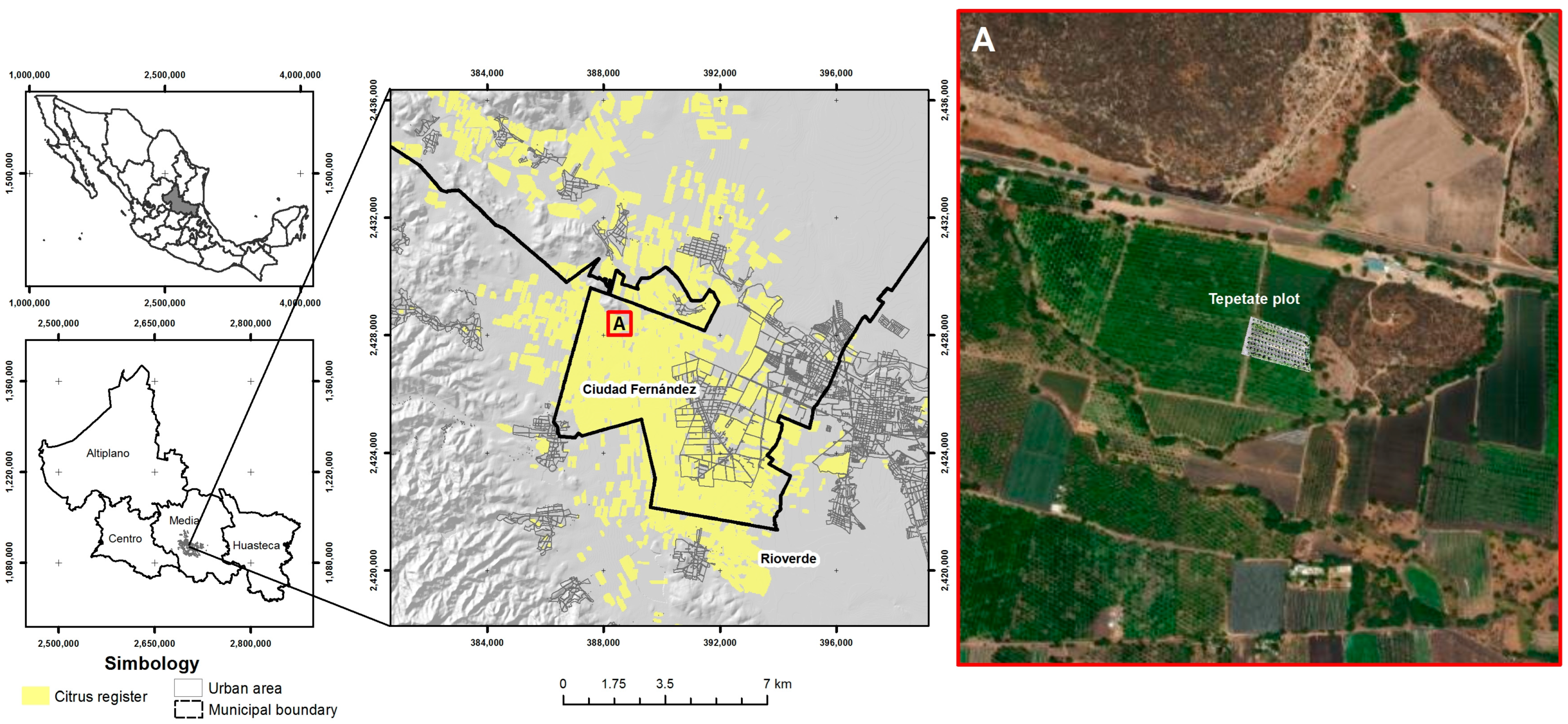
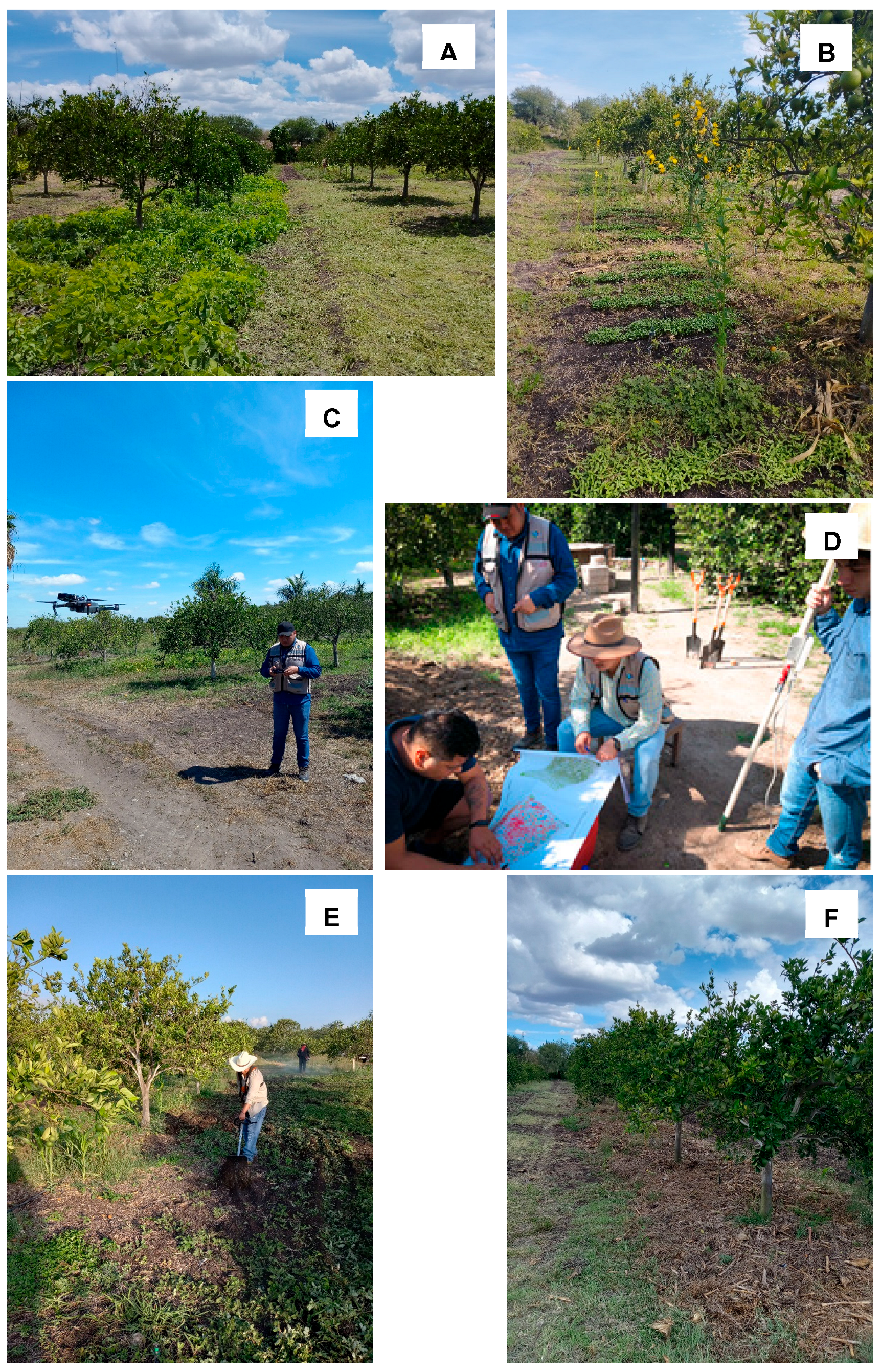
2.1. Location and Experiment Setup

The present study was conducted in a citrus orchard in the central zone of San Luis Potosí, Mexico, in a Valencia orange orchard in the municipality of Ciudad Fernandez (Rioverde watershed). The plot was identified as “Tepetate” and is under permanent irrigation, as can be seen in Figure 1 and Figure 2.
The central zone of the state is one of the four geographical regions into which the state is divided. To the south is Rioverde Basin, the citrus-growing region with the highest production value in the state, made up of municipalities of Ciudad Fernandez, Rioverde, Lagunilla, and San Ciro de Acosta, which cover 4741 ha (14.9% of the state) and account for 59.4% of the state’s production value. This agricultural basin has the best yield per hectare and the best average price in the country, surpassing the national and state averages.
This is due to the maintenance of a phytosanitary status with the low prevalence of native fruit flies since 2010 to date, achieved through the MOSCAFRUT plant protection campaign and the weekly application of sterile flies [15,16].
The producer made 10% of his land available for the establishment of alternatives (Figure 2). This research focused on the establishment of 7 agroecological alternatives in the period from June to November 2023, with the care and training of growers and continuous precision sampling. The treatments were carried out on 7 rows of orange trees aged between 5 and 8 years old, covering an area of 1840 m2. All trees tested positive for HLB, the main plant disease in the area [17]. Studies have shown that both the NDVI and the occurrence of HLB are influenced by climatic conditions, especially by vegetative stress processes [18].
The use of legumes in citrus cultivation helps with weed control, nitrogen fixation, and soil disinfection. Crotalaria, for example, helps reduce fungal problems, and Mucuna helps control nematode problems and promotes better nutrient transport. They keep the soil covered to prevent erosion, improve soil structure, and promote soil loosening (organic tillage) and can potentially serve as feed for livestock [13,19].
In treatment A1, the orchard was cleared with a brush cutter.
In treatments A2, A3, and A4, the soil was prepared with a tractor and a rotary tiller for sowing legumes to create a living cover: Mucuna pruriens was sown in A2, Canavalia ensiformis in A3, and Crotalaria juncea in A4. The seeds were sown in June 2023 by broadcasting at a density of 40 kg ha−1.
In treatment A5, a dead cover with maize residues was applied. For establishment, 31,000 kg ha−1 of maize stubble was sown in June 2023.
Treatment A6 used Herbitech™ by Biotech Mexico (Uruapan, Mexico), a bioherbicide and a systemic contact herbicide with a broad spectrum of activity for post-emergence weed control. It works quickly and effectively to control unwanted plants and grasses in crops. Its formulation consists of 100% natural ingredients such as mullein, coconut oil, pine resin, Puccinia fungus, and papain.
The bioherbicide (15 mL L−1) was applied using a mechanical backpack sprayer pressurized with CO2 and equipped with a four-tip bar pattern, model Teejet XR 110.02, with a pressure of 178 kPa and a distance of 0.5 m between tips. The walking speed during spraying was 1 m s−1; a volume of 200 L ha−1 was used.
Treatment A7 was used as a control, as no agronomic measures were carried out (Table 1).
For the detection of glyphosate traces in weeds in the field, 21 samples were taken and analyzed by Raman spectroscopy with a XploRA Plus™ system by Horiba Ltd. (Kioto, Japan) [20]. The soil type identified in the plot is Phaeozem [21], and the results of soil analysis showed that the plot has high content of organic matter (oxygen (O), calcium (Ca), copper (Cu), and sulfur (S)) and low content of iron (Fe), zinc (Zn), and manganese (Mn). In addition to glyphosate and Paraquat, 6 highly hazardous pesticides (HHPs) were used for weed control on the trial site [17].
The thirteen different weed species in Table 2 were identified using the SENASICA [15] and IGL-Survey 123 sampling method [22]. In this agroecological transition plot, 4 glyphosate-resistant and 6 glyphosate-tolerant weeds were found using Raman spectroscopy [20]. The methodology for agroecological field treatments was determined using the MEIA model [9,10]. In monitoring and quantifying the results, the precision agriculture (agromatics) methodology was applied, which consists of taking advantage of technology; observing, measuring, and analyzing temporal and spatial variability; and using all these data to indicate the agroecological treatments that provide the best results in weed control, both in agricultural terms and in terms of cost.

2.2. General Workflow

Figure 3 shows the methodological proposal developed for this study, which consists of three procedures: (a) collection of georeferenced ID-survey information on weeds through the sampling design and the resulting spatial modeling; (b) spectral survey (reflectance per tree) through radiometric campaigns and the creation of spectral libraries, resulting from the processing of the UAV images (mosaic and creation of the NDVI algorithm) and the application of statistical analysis on the obtained spectral results; and (c) the correlation of both spatial modeling and spectral results was calculated by linear regression, and the significance level was determined by the agroecological treatment (Figure 3).

2.3. Data Collection

Geographers, geomaticians, and agroecologists who practice precision agriculture often use different tools and data collection methods to analyze different variables and find the best course of action for both the producer and experimental plot. This is carried out to contribute to an agroecological transition that is integrated into the most sustainable biocultural region while improving production and investment costs. Data collection is at the heart of precision agriculture and farmer empowerment, which translates into georeferenced weed monitoring by using treatments.

2.3.1. Ground Truth

To determine the effectiveness of alternatives, 5 control evaluations were conducted at 30, 60, 90, 120, and 150 DDE (days after establishment) to estimate the percentage of weeds in each of the alternatives. During the evaluations, the number of individuals of emerged weeds per m2 was counted through a metallic quadrant (0.5 m × 0.5 m), counting the weeds that were within the quadrant [15]. Figure 3 also shows how the Survey 123 application was used to collect data. A total of 20,500 field data points were collected during sampling. With this in mind, field data collection was supplemented by digital and cartographic methods. All sampling data were imported into a GIS and then stored in a geodatabase. For this purpose, data import, analysis, management, and mapping were carried out using the ArcGIS 10.2.

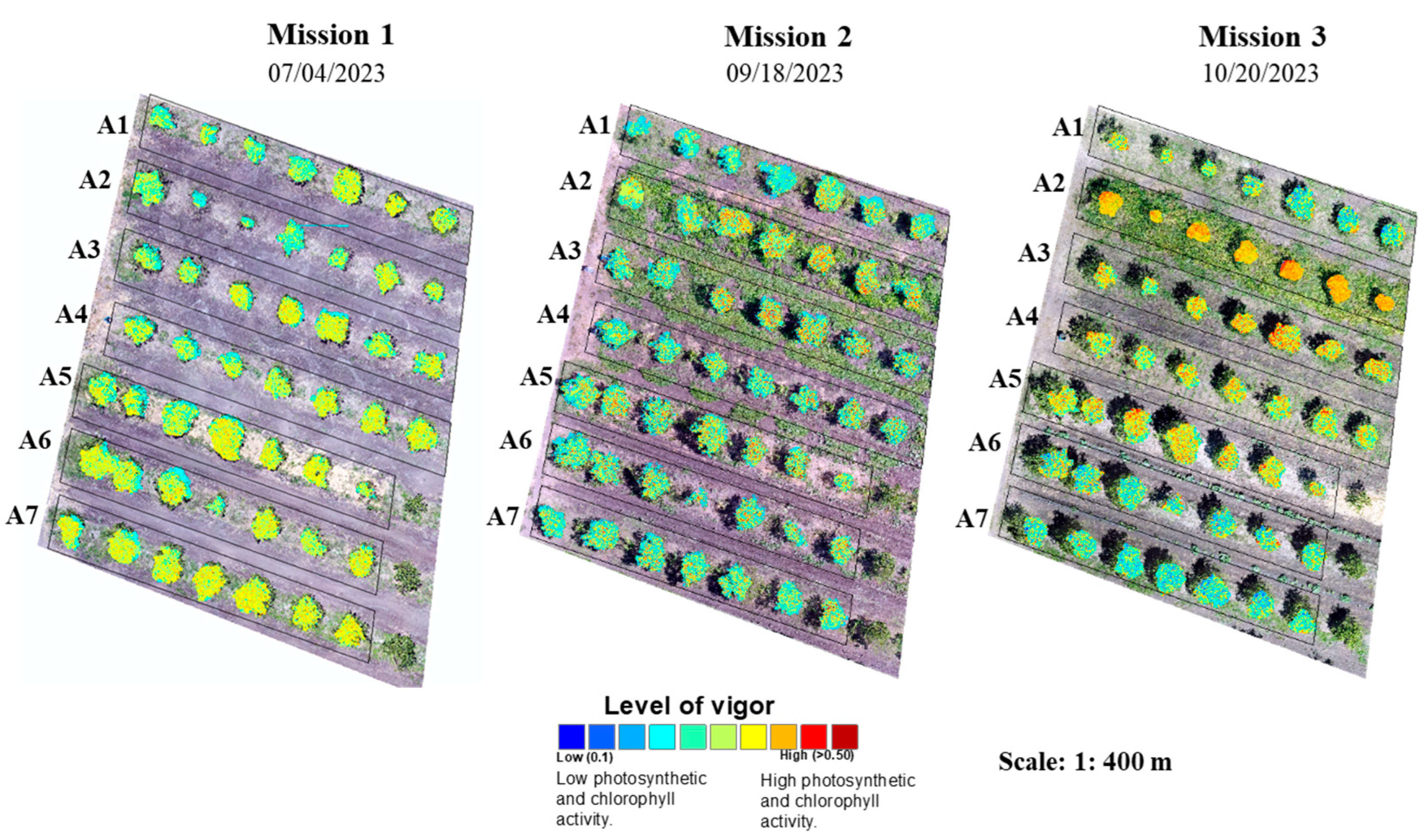
2.3.2. Image Collection

Monitoring with infrared cameras (UAV) is fundamental as they determine the spectral response of the tree to any agroecological treatment. A spectral comparison was made with the trees that showed greater vegetative vigor.
For this purpose, the vegetative vigor (NDVI) for each of the orange alternatives was determined using the Mavic 2 drone (SZ DJI Technology Co., Ltd., Shenzhen, China) with a visible 4K camera to obtain the georeferenced orthomosaic of the corresponding plot and the Mapir (MAPIR, Inc., San Diego, CA, USA) infrared camera to obtain the vegetation index measurements, such as NDVI, which includes data acquisition, information extraction, and field application [23].
Table 3 shows the main characteristics of the 3 flight missions conducted according to the phenological stage of the citrus and weeds present. In addition, the requirements for the operation of a pilot-operated aircraft system (RPAS) in Mexican airspace and the formats for UAV reports established in the official Mexican standard NOM-107-SCT3-2019 [24] and in the official protocols of LANGIF-UASLP were met. In 2023, severe drought caused sprouting to decrease (also in risk systems), and in July, the orange trees were in the post-harvest and weed growth phase (M1—weed growth). In August, the orange trees began to sprout with increasing rainfall (M2—growth and ripening); in September, the orange trees began to flower, and the weeds began to grow strongly (M3—seed production and vegetative development).
The first two missions dealt with the first 7 trees of each row, and mission 3 covered the entire row of orange trees depending on the grower’s interest.
Similarly, the relationship between weed cover and NDVI, derived from all survey data for each of the treatments and the corresponding flights of the Mapir (spectral) camera UAV, was modeled in a regression-adjusted manner (R2).

2.4. Data Analysis

It must be said that large amounts of fertilizers, pesticides, and herbicides were used on this plot until the arrival of the work team. To determine the performance and outcome of agroecological treatments in eliminating glyphosate-tolerant and -resistant weeds, ID-survey in the Origin Lab program 2018 was used. One-way analysis of variance (ANOVA) was used to determine the effects of treatments applied using the Tukey test with XLSTAT 2025.1. To determine the linear dependence between the results of two technologies, Pearson’s correlation was applied according to the following formula:
r = ( X i X ¯ ) Y i Y ¯ X i X ¯ 2 Y i Y ¯ 2
where Xi and Yi represent the values of the variables, and X ¯ and Y ¯ represent the mean values of X and Y, respectively. This provided the opportunity to correlate the percentage of weed removal and the NDVI values, which quantifies the linear relationship between two continuous variables.
Pearson’s correlation coefficient is expressed as −1 to 1. In this sense, a value of 1 indicates a perfect positive correlation, i.e., as one variable increases, the other increases proportionally. A value of −1 indicates a negative correlation, i.e., an increase in one variable is accompanied by a decrease in the other, and a value of 0 means that there is no linear relationship between the variables [25].

3. Results and Discussion

The weed survey identified 13 weed species in the 7 alternatives, of which 2 were the most abundant on the farm and were cataloged as resistant to glyphosate [3], namely Parthenium hysterophorus and Eleusine indica. Table 4 summarizes how the use of GIS also enabled the creation of maps showing the spatial distribution of weeds present on the farm.
Of the seven experimental treatments, dead cover (A5) was the one that reduced pre-emergence weed emergence by 90%, followed by Mucuna pruriens (A2) at 75% from the last observation date. In treatment A7 with 120% weed growth, which was a control and in which no maintenance or bioherbicide application was carried out, the number of individual specimens per m2 remained at a higher level from the first to the third evaluation (Figure 4).
Mucuna pruriens (A2) was the one that adapted the best to the site and quickly contributed to nitrogen fixation. Figure 5 shows that the brush cutter (A1) and the bioherbicide (A6), together with the control (A7), did not contribute to the increase in vegetative vigor (nutrient and moisture content of the orange trees). One-way analysis of variance showed that the value of vegetative vigor was significantly dependent on the agroecological treatment of the orange trees.
In mission 1 (one month after planting), most trees had an unchanged vigor level (NDVI). After two months, treatments A2, A3, and A5 were the first to show a significant spectral response.
In mission 3, alternatives A2 (Mucuna pruriens), A3 (Vicia sativa), and A5 (dead vegetation) increased the percentage of vegetative vigor, while alternatives A1 (brush cutter), A6 (bioherbicide), and A7 (control) showed a lower percentage of vigor under the same irrigation conditions.
The agroecological treatment with the highest correlation was A5: dead cover with R2 = 0.83, followed by living cover A2: Mucuna pruriens. This was followed by the intermediate results of covers A3 and A4. A7 was the control with an R2 = 0.189, which clearly shows that agroecological treatment very quickly leads to an improvement in the nutrient content of orange trees.
It was also observed that the root system of the trees to which the mulch of Mucuna pruriens was added improved, which must have influenced the improvement in the vitality of the trees.
In addition, the cost of each treatment was calculated in Mexican pesos and then converted to US dollars at the time of calculation (18 March 2025) using the fixed exchange rate (used to settle US-dollar-denominated debts) [26] (Table 5).
As can be seen, treatment A2, in which a live plant cover of Mucuna pruriens was added, is similarly effective in increasing the vegetative vigor of the orange trees on which it was applied. In addition, this legume was the one that best adapted to the soil and increased nitrogen fixation in the soil, which must be related to an improvement in the root system. On the other hand, the cost of treatment A2 is significantly lower (USD 2666) than that of treatment A5 (USD 3409), but it also has the additional benefits of the first treatment.

4. Conclusions and Recommendations

Field mapping is one of the most important aspects of precision agriculture, and in the future, community drones may enable young rural entrepreneurs, who could be the sons of producers (the generational shift of the new agro-social paradigm), to demonstrate the social, nutritional, and environmental benefits of agroecological practice. Thanks to drone technology, it will be easier to identify problem areas and create a complete and accurate map of agroecological transitions [27]. Dead cover (A5) was the one that prevented the emergence of weeds the most before sowing [28]. This treatment is expensive in the region, as it was made from corn residues and amounted to USD 3409 ([26]: Table 5). Therefore, it would be necessary to look for other types of mulches with organic residues from local crops or plantations, not only to reduce costs but also to create a sustainable economy, such as cactus stubble. In the citrus-growing area of Huasteca of San Luis Potosí, residues from sugar cane plantations could be used [29]. The next recommended treatment for the Rioverde citrus-growing zone would be to cover Mucuna pruriens, although the cost is relatively high (USD 2666). It will be necessary to sensitize growers to care for it, and it is advisable to use it as livestock feed. The bioherbicide did not achieve significant results in the area, as more than 67% of the weeds were tolerant or resistant to glyphosate [30], so its effectiveness was very low, although it is less expensive (USD 119). Brushcutting is a good field tool for the maintenance and pruning of legumes, but it should not be the only treatment. The mapping of weeds can be a useful tool for localized control, making in-field removal more streamlined, effective, and economical. Similarly, live cover crops (legumes) have dual benefits as they control weeds pre-emergence and are highly likely to fix nitrogen [31], improve secondary roots and absorptive hairs, and have the power to expose the phloem, which is the main problem caused by HLB (this is still being investigated by the working group). The use of legumes plays a triple role in diversifying the citrus agroecological landscape: It improves tree nutrition, produces natural enemies against insect pests, and serves as livestock feed [25]. The use of UAVs and multispectral cameras enables a precise and quantifiable assessment of alternatives for glyphosate replacement based on spectral information, such as the NDVI for this orange-growing area [32]. The mapping of weeds can be a useful tool for localized control, making their elimination on farms rational, effective, and economical.

Author Contributions

Conceptualization, M.G.G.M., A.C.T., R.S.R., O.R.C. and T.R.G.; methodology, M.G.G.M., R.S.R. and C.C.S.; validation, M.G.G.M., A.C.T. and T.R.G.; formal analysis, C.C.S. and P.P.M.; investigation, P.P.M. and C.C.S.; data curation, A.C.T.; writing—original draft preparation, M.G.G.M., P.P.M. and O.R.C.; writing—review and editing, O.R.C., R.S.R. and C.C.S.; supervision, M.G.G.M., T.R.G. and A.C.T.; project administration, R.S.R. and M.G.G.M. All authors have read and agreed to the published version of the manuscript.

Funding

This research was funded by Autonomous Universidad Autónoma Chapingo Consejo Nacional de Ciencia y Tecnología (CONACYT) by means of the Project 2023 “Agroecological alternatives for the progressive substitution of glyphosate-based herbicides in fruit trees and staple crops” through the F003 Project “Programas Nacionales Estratégicos de Ciencia, Tecnología y Vinculación con los sectores social, público y privado”.

Data Availability Statement

The data presented are available upon request from the corresponding author. The data are not publicly available due to privacy or ethical reasons.

Conflicts of Interest

The authors declare no conflict of interest.

Abbreviations

The following abbreviations are used in this manuscript:
GITGeographic Information Technology;
GLONASSSatellite positioning system with characteristics very similar to GPS in practice;
RPASRemotely piloted aircraft systems;
UASUnmanned aerial systems;
Survey 123A simple and intuitive form-centric data-gathering solution. Create, share, and analyze surveys in just three easy steps;
IGLIntelligent georeferencing logs;
HLBHuanglongbing (HLB) is a bacterial infection of citrus trees transmitted by the Asian citrus psyllid Diaphorina citri;
IDIntelligent database;
NDVINormalized difference vegetation index;
DDEDays after establishment;
ANOVAAnalysis of variance;
R2Coefficient of determination.

References

  1. Radosevich, S.R.; Holt, J.S.; Ghersa, C.M. Ecology of Weeds and Invasive Plants; Jonh Wiley & Sons, Inc.: Hoboken, NJ, USA, 2007; pp. 83–101. [Google Scholar]
  2. Zaller, J.G. What is the problem? Pesticides in our everyday life. In Daily Poison; Springer: Cham, Switzerland, 2020; pp. 1–125. [Google Scholar]
  3. Heap, I. The International Herbicide-Resistant Weed Database. 2023. Available online: www.weedscience.org (accessed on 27 November 2024).
  4. CONACYT. Consejo Nacional de Ciencia y Tecnología. Expediente Científico Sobre Glifosato y los GM. 2020. Available online: https://secihti.mx/wp-content/uploads/documentos/glifosato/Dossier_formato_glifosato.pdf (accessed on 26 November 2024).
  5. Alcántara-de la Cruz, R.; Cruz-Hipolito, H.E.; Domínguez-Valenzuela, J.A.; De Prado, R. Glyphosate ban in Mexico: Potential impacts on agriculture and weed management. Pest Manag. Sci. 2021, 77, 3820–3831. [Google Scholar] [CrossRef] [PubMed]
  6. SEGOB. Secretaría de Gobernación. DECRETO por el que se Establecen las Acciones que Deberán Realizar las Dependencias y Entidades que Integran la Administración Pública Federal, en el Ámbito de sus Competencias, para Sustituir Gradualmente el uso, Adquisición, Distribución, Promoción e Importación de la Sustancia Química Denominada Glifosato y de los Agroquímicos Utilizados en Nuestro País que lo Contienen Como Ingrediente Activo, por Alternativas Sostenibles y Culturalmente Adecuadas, que Permitan Mantener la Producción y Resulten Seguras para la Salud Humana, la Diversidad Biocultural del país y el Ambiente. 2020. Available online: https://www.dof.gob.mx/nota_detalle.php?codigo=5609365&fecha=31/12/2020#gsc.tab=0 (accessed on 24 November 2024).
  7. CONACYT. Consejo Nacional de Ciencia y Tecnología. Manejo Ecológico Integral de Arvenses en México. 2021. Available online: https://alimentacion.conahcyt.mx/glifosato/descargables/alternativas/materiales/MEIA_01_Presentacion.pdf (accessed on 26 November 2024).
  8. Gómez-Cruz, M.A.; Hernández-Andrade, M.A.; Gómez-Tovar, L. Siembra de Leguminosas para el Manejo de Arvenses y la Sustitución de los Herbicidas a Base de Glifosato. Publicaciones Agroecológicas. 2022. Available online: https://www.researchgate.net/publication/365298115_Siembra_de_leguminosas_para_el_manejo_de_arvenses_y_la_sustitucion_de_los_herbicidas_a_base_de_glifosato (accessed on 8 December 2024).
  9. De Marchi, M.; Diantini, A.; Pappalardo, S.E. Drones and Geographical Information Technologies in Agroecology and Organic Farming Contributions to Technological Sovereignty; CRC Press: Boca Raton, FL, USA, 2022; pp. 1–308. [Google Scholar]
  10. Kumar, A.; Kumar, S.; Lal, P.; Saikia, P.; Srivastava, P.K.; Petropoulos, G.P. General Introduction to GPS/GNSS technology. In GPS and GNS Technology in Geosciences; Elsevier: Ámsterdam, The Netherlands, 2021; pp. 3–20. [Google Scholar]
  11. Paneque-Gálvez, J.; Vargas-Ramírez, N.; Napoletano, B.; Cummings, A. Grassroots innovation using drones for indigenous mapping and monitoring. Land 2017, 6, 86. [Google Scholar] [CrossRef]
  12. Vargas-Ramírez, N.; Paneque-Gálvez, J. The Global Emergence of Community Drones (2012–2017). Drones 2019, 3, 76. [Google Scholar] [CrossRef]
  13. Gómez-Cruz, M.A.; Gómez-Tovar, L.; Schwentensius-Rindermann, R.; Rodríguez-Nieto, I.M.; Reyes-Rosales, R.; Villatoro-López, M. Guía Agroecológica Para la Producción de Naranja Orgánica. Publicaciones Agroecológicas. 2017. Available online: https://www.researchgate.net/publication/324248829_Guia_agroecologica_para_la_produccion_de_naranja_organica (accessed on 15 October 2024).
  14. Rocha, F.; Neto, A.O.; Bottega, E.; Guerra, N.; Rocha, R.; Vilar, C. Weed mapping using techniques of precision agriculture. Planta Daninha 2015, 33, 157–164. [Google Scholar] [CrossRef]
  15. SENASICA. Servicio Nacional de Sanidad, Inocuidad y Calidad Agroalimentaria. Manual Operativo de la Campaña Contra Malezas Reglamentadas. Servicio Nacional de Sanidad, Inocuidad y Calidad Agroalimentaria. 2013. Available online: https://www.gob.mx/cms/uploads/attachment/file/108116/Manual_Operativo.pdf (accessed on 27 November 2024).
  16. CESAVESLP. Comité Estatal de Sanidad Vegetal de San Luis Potosí. Campaña Nacional contra Mosca de la Fruta. 2024. Available online: https://www.cesaveslp.org.mx/Moscas.html (accessed on 27 November 2024).
  17. Galindo-Mendoza, M.G.; Aldaz-Galicia, N.Y.; Contreras-Servín, C.; Saldierna-Salas, G.; Almendarez-Rocha, S.D. Articulación territorial de la gestión de plaguicidas en el marco de la protección fitosanitaria. El caso del valle agrícola de Rioverde y Ciudad Fernández, San Luis Potosí. Investig. Geogr. 2021, 106, 1–19. [Google Scholar] [CrossRef]
  18. Contreras-Servin, C. Condiciones Climáticas Asociadas al Establecimiento y Dispersión de la Diaphorina Citri y la Enfermedad del Huanglongbing (HLB) en México. In Entomología Mexicana; Universidad Autónoma de San Luis Potosí: San Luis Potosí, México, 2012; pp. 101–117. [Google Scholar]
  19. Brunner, B.; Beaver, J.; Flores, L. Hoja Informativa. 2011. Available online: https://www.yumpu.com/es/document/read/9154627/mucuna-pruriens-agricultura-organic-a-puerto-rico (accessed on 20 October 2024).
  20. Galindo-Mendoza, M.G.; Schwentensius-Rindermann, R.; Barrera-López, V.A.; Navarro-Contreras, H.R.; Hernández-Vázquez, B.; Saldierna-Salas, G. Traces of glyphosate in corn (Zea mays L.) and avocado (Persea americana Mill.) weeds supported by vant and raman spectroscopy. Agrociencia 2023, 57, 1–15. [Google Scholar] [CrossRef]
  21. INEGI. Instituto Nacional de Estadística y Geografía. Prontuario de Información Geográfica Municipal de los Estados Unidos Mexicanos. Ciudad Fernández, San Luis Potosí. 2009. Available online: http://www3.inegi.org.mx/contenidos/app/mexicocifras/datos_geograficos/24/24011.pdf (accessed on 12 October 2024).
  22. LaNGIF. P-CONAHCYT-UACH NO. 322610. Alternativas Agroecológicas Orientadas a la Sustitución Gradual de Herbicidas a Base de Glifosato en Frutales y Cultivos básicos 2022–2024. Available online: http://langif.uaslp.mx/faros_agroecologicos.php#:~:text=Este%20proyecto%20se%20fundamenta%20en,para%20frutales%20y%20cultivos%20b%C3%A1sicos (accessed on 10 October 2024).
  23. Zhang, J.; Huang, Y.; Pu, R.; Gonzalez-Moreno, P.; Yuan, L.; Wu, K.; Huang, W. Monitoring plant diseases and pests through remote sensing technology: A review. Comput. Electron. Agric. 2019, 165, 104943. [Google Scholar] [CrossRef]
  24. SEGOB. Secretaría de Gobernación. NORMA Oficial Mexicana NOM-107-SCT3-2019, Que Establece los Requerimientos para Operar un Sistema de Aeronave Pilotada a Distancia (RPAS) en el Espacio Aéreo Mexicano. 2019. Available online: https://www.dof.gob.mx/normasOficiales/8006/sct11_C/sct11_C.html (accessed on 31 October 2024).
  25. Schober, P.; Boer, C.; Schwarte, L.A. Correlation Coefficients: Appropriate use and interpretation. Anesth. Analg. 2018, 126, 1763–1768. [Google Scholar] [CrossRef] [PubMed]
  26. SIE. Sistema de Información Económica. Portal del Mercado Cambiario. 2024. Available online: https://www.banxico.org.mx/tipcamb/main.do?page=tip&idioma=sp (accessed on 27 November 2024).
  27. Petraki, D.; Gazoulis, I.; Kokkini, M.; Danaskos, M.; Kanatas, P.; Rekkas, A.; Travlos, I. Digital Tools and Decision Support Systems in Agroecology: Benefits, Challenges, and Practical Implementations. Agronomy 2025, 15, 236. [Google Scholar] [CrossRef]
  28. Osorio-Espinoza, H.; Leyva-Galán, Á.; Toledo-Toledo, E. Influence of live and dead covers on weeds, in an agroecosystem with rambutan (Nephelium lappaceum L.) in Mexico. Cultiv. Trop. 2023, 44, 1–7. [Google Scholar]
  29. Bassey, M.S.; Shittu, E.A.; Etim, E.E.; Etopobong, E.J. Soil and sugar quality improvement influenced by mulching and weed management practices in Nigeria. J. Plant Dev. 2024, 31, 97–103. [Google Scholar] [CrossRef]
  30. Damgaard, C.; Strandberg, B.; Ehlers, B.; Reisner, H.R.; Tune, S.M. Effect of nitrogen and glyphosate on the plant community composition in a simulated field margin ecosystem: Model-based ordination of pin-point cover data. Environ. Pollut. 2024, 315, 120377. [Google Scholar] [CrossRef] [PubMed]
  31. Mulinge, J.M.; Saha, H.M.; Mounde, L.G.; Walsiwa, L.A. Effects of Legume Cover Crops on Orange (Citrus sinensis) Fruit Weight and Brix. Int. J. Plant Soil Sci. 2018, 21, 1–9. [Google Scholar] [CrossRef]
  32. Eide, A.; Koparan, C.; Zhang, Y.; Ostlie, M.; Howatt, K.; Sun, X. UAV-Assisted Thermal Infrared and Multispectral Imaging of Weed Canopies for Glyphosate Resistance Detection. Remote Sens. 2021, 13, 4606. [Google Scholar] [CrossRef]
Figure 1. Location of the study area.
Drones 09 00398 g001
Figure 2. Transitional agroecological landscape in orange plantations, “Tepetate”, SLP. Mucuna pruriens (A), Crotalaria juncea (B), Mission1 UAV (C), explanation of the spectral map to the producer (D), brush mower treatment (E), and dead maize stubble (F).
Drones 09 00398 g002
Figure 3. Methodological scheme of the GIS and UAV agromatic assessment of precision agriculture structures in agroecological treatments.
Drones 09 00398 g003
Figure 4. Comparison of the effectiveness of treatments in relation to the percentage of emergence of weeds using georeferenced log and spatial modeling.
Drones 09 00398 g004
Figure 5. UAV missions and comparison of tree vitality by agroecological alternative.
Drones 09 00398 g005
Table 1. Experimental treatments established in the Tepetate plot in 2023–2024.
TreatmentMechanical Implementation and Live–Dead
Covers
Dosage and Number of Plants
A1Brush cutter7
A2Mucuna pruriens7
A3Canavalia ensiformis7
A4Crotalaria juncea7
A5Dead corn cover7
A6Bioherbicide10 mL/L
A7Control witness7
Table 2. Weeds identified in the Tepetate plot.
Positive WeedsNegative Weeds
1. Acalypha setosa11. Malva silvestris
2. Amaranthus palmeri12. Euphorbia prostrata
3. Argemone munita13. Solanum elaeagnifolium
4. Bidens odorata
5. Boerhavia erecta
6. Parthenium hysterophorus
7. Stevia berlandieri
8. Taraxacum officinale
9. Trifolium repens
10. Elusine indica
Table 3. UAV missions in the orange plantation plots.
Flight MissionSensorFlight Date
(Acquisition)
Flight Height (m)N of ImagesSurface (m2) Pixel (GSD) (cm)
1Mapir Survey3, 1″ CMOS (visible)4 July 20232512018401
218 August 202314618401
320 October 20239018401.17
Table 4. Glyphosate-resistant and -tolerant weeds by the number of individuals and frequency in all experimental treatments.
Scientific NameParthenium hysterophorusEleusine indica
(plants/m2)
Trifolium repens
bs30 DAE60 DAE90 DAEbs30 DAE60 DAE90 DAEbs30 DAE60 DAE90 DAE
TreatmentsA1—Brush cutter23020018714230028825019017613124842
A2—Mucuna pruriens7062501017015775251491037650
A3—Canavalia ensiformis98875030140128120110136834035
A4—Crotalaria juncea958950251501217069100848912
A5—Dead corn cover6555279130114361012912112
A6—Bioherbicide12511050253002836959504846
A7—Control witness11212012813425028034037074656879
bs = Before establishment; DAE = days after establishment.
Table 5. Effectiveness and costs of the treatments used.
TreatmentMechanical Implement and Live–Dead CoversR2 Between Weed Removal and NDVICost of Treatment USD/ha
A1Brush cutter0.331217
A2Mucuna pruriens0.8232666
A3Canavalia ensiformis0.5252666
A4Crotalaria juncea0.5902897
A5Dead corn cover0.8363409
A6Bioherbicide0.410119
A7Control witness0.1890
Disclaimer/Publisher’s Note: The statements, opinions and data contained in all publications are solely those of the individual author(s) and contributor(s) and not of MDPI and/or the editor(s). MDPI and/or the editor(s) disclaim responsibility for any injury to people or property resulting from any ideas, methods, instructions or products referred to in the content.

