Article

A Flight Route Design Method Considering Multi-Hop Communication Using Delivery UAVs

1
Department of Information Systems, Faculty of Applied Information Science, Suwa University of Science, 5000–1 Toyohira, Chino 391-0213, Japan
2
Department of Information and Communication Engineering, Faculty of Informatics, Kogakuin University, 1–24–2 Nishi-Shinjuku, Shinjuku-Ku, Tokyo 163-8677, Japan
*
Author to whom correspondence should be addressed.
Drones 2025, 9(11), 751; https://doi.org/10.3390/drones9110751
Submission received: 11 September 2025 / Revised: 24 October 2025 / Accepted: 27 October 2025 / Published: 29 October 2025
(This article belongs to the Special Issue Urban Air Mobility Solutions: UAVs for Smarter Cities)

Highlights

What are the main findings?
  • The flight path using Waypoints (WPs) improves the throughput compared to that without WPs.
  • We confirmed that the proposed route selection algorithm that places WPs to minimize the communication distance between DPs can improve the average throughput characteristics.
What is the implication of the main finding?
  • The proposed method offers a practical solution for establishing a UAV-based communications platform in areas where it is challenging to install ground-based stations in emergencies.
  • Realizing a multi-hop communications system using delivery UAVs will enable the creation of a low-cost communications system.

Abstract

In recent years, the use of Unmanned Aerial Vehicles (UAVs) has been widely investigated, with particular attention to their potential applications within smart city initiatives. In urban areas, UAV-based delivery services are expected to help address the shortage of truck drivers while also contributing to the promotion of carbon neutrality. Furthermore, the use of multiple UAVs as a communication platform through multi-hop UAV relaying has been studied. UAV-based communication platforms are gaining attention as cost-effective solutions in regions where deploying terrestrial base stations is challenging, such as mountainous areas and remote islands, as well as in emergency situations like natural disasters. Among UAV-based communication platforms, multi-hop UAV relaying is attracting attention as an effective means. However, when employing multi-hop UAV relaying, challenges arise in scenarios where the distance between the source and destination is large, including increased costs due to the need for a larger number of UAVs and reduced throughput caused by the increase in hop count. To address these issues, this paper proposes a flight path design for UAVs in a multi-hop communication system utilizing delivery UAVs, aiming to improve throughput between destinations. The proposed method targets communication between a source and multiple destinations by strategically placing relay points (Way Points: WPs) along the flight paths. By routing UAVs through WPs, new communication links are established, enabling the direct construction of networks between destinations. This approach reduces the number of hops and ensures stable communication at a constant speed. For WP placement algorithms, we propose two methods: a centroid-based method and a shortest-communication-distance-based method. Simulation results demonstrate that the proposed approach enhances throughput.

1. Introduction

As the introduction cost of Unmanned Aerial Vehicles (UAVs) decreases, they have become increasingly popular for recreational purposes such as photography and video streaming. More recently, UAVs have also been actively utilized in critical applications, including delivery services in smart cities and real-time monitoring, thereby raising expectations for their potential [1,2,3]. Traditionally, UAVs have mainly been employed as aerial user equipment (UE). However, with advancements in UAV weight reduction and the miniaturization of onboard communication devices, new proposals have emerged that envision the simultaneous deployment of multiple UAVs, leveraging them as communication platforms [4,5,6].
UAV-based communication platforms are considered useful as a means of communication in areas where terrestrial communication cannot adequately meet demand, as well as in emergencies. For instance, terrestrial communication requires the installation of terrestrial-based stations (BSs); however, in sparsely populated mountainous regions or remote islands, the cost of establishing such infrastructure is expensive for the limited communication demand, resulting in low cost-effectiveness. In contrast, by deploying multiple UAVs as communication infrastructures, a higher cost-effectiveness of communication platforms can be expected [7,8]. Moreover, in cases where urgent or temporary communication demand arises—such as in smart agriculture, inspection of transportation infrastructure, mountain rescue operations, or disaster situations—the mobility of UAVs makes them a highly effective temporary communication solution [9,10,11]. Among these, we mainly consider the scenario of emergency communications during disasters.
UAV-based communication platforms can be categorized into two approaches: operating UAVs as base stations and operating them as relays [12]. In the base-station-based approach, UAVs are deployed on a large scale and connected to already deployed terrestrial BSs, thereby being integrated into the cellular network as new aerial BSs. However, in such UAV-integrated cellular systems, Line-of-Sight (LOS) communication is dominant between UAVs and terrestrial BSs. As a result, compared to terrestrial UEs, UAVs are more susceptible to inter-cell interference (ICI) from a wider range of cells, which poses a critical issue.
Here, ICI arises in both the uplink, from UE to UAV, and the downlink, from UAV to UE. In uplink communications, UAVs are likely to suffer radio wave interference from a large number of BSs operating on the same channel but unrelated to the UAV, which may lead to a significant throughput degradation. In the downlink, since UAVs operate at high altitudes, radio waves transmitted by a UAV can be received by multiple terrestrial BSs that are not associated with it, raising serious concerns about ICI to existing terrestrial UEs [13,14]. Such an ICI becomes a major factor in severely degrading the downlink performance of the overall terrestrial network. In terrestrial cellular networks, a variety of interference mitigation techniques, collectively known as Inter-Cell Interference Coordination (ICIC), have been widely adopted to cope with such ICI [15]. However, these methods are mainly designed to reduce interference affecting terrestrial UEs, and thus may not be effective in addressing the unique interference between UAVs and terrestrial BSs. Furthermore, directional antennas have also been investigated as a means to reduce ICI [16,17]. Nevertheless, since these approaches generally assume fixed directional patterns, there exist scenarios in UAV relay networks involving mobility where interference cannot be sufficiently suppressed.
To this end, in order to integrate UAVs into cellular systems, increasing attention has been directed toward new communication approaches that do not rely on cellular infrastructure, specifically the use of UAVs as relays [12]. In this relay-based approach, UAVs operate within a dedicated communication system. Therefore, ICI, which would otherwise arise when UAVs function as BSs, does not need to be considered. Accordingly, this study focuses on communication methods that employ UAVs as relays. The remainder of this paper is organized as follows: Section 2 reviews related work on UAV relay techniques. Section 3 describes the proposed system model, while Section 4 presents the proposed UAV trajectory design method. Section 5 provides performance evaluations of the proposed system, and Section 6 concludes the paper.

2. Related Research

Let us describe communication methods that employ UAVs as relays. Relay schemes using UAVs can be broadly classified into those that utilize a single UAV and multiple UAVs.
We first discuss the single-UAV relay approach [18,19,20,21,22,23]. In Ref. [18], both amplify-and-forward (AF) and decode-and-forward (DF) single-UAV relay schemes are investigated. In Ref. [19], a bidirectional AF UAV relay system is studied, where the sum rate of uplink and downlink transmissions is optimized through UAV positioning and power control. In Ref. [20], the optimal UAV relay position is derived based on a theoretical analysis of outage probability in the rate region. In Ref. [21], a UAV relay cooperating with a cellular base station is considered, and a deep reinforcement learning-based interference mitigation and resource allocation scheme is proposed to improve terrestrial UE throughput. In Ref. [22], a novel cooperative beamforming technique for cellular downlink is introduced to mitigate interference caused by co-channel terrestrial communication to the UAV relay. In Ref. [23], UAVs are used as mobile base stations to collect data from a subset of sensor nodes, addressing the energy consumption challenge caused by large-scale sensor transmissions. The energy minimization problem is formulated as a combinatorial optimization task and solved using sparse sensing, which incorporates neighborhood search and a greedy algorithm, thereby reducing overall energy consumption. Single-UAV relay schemes offer advantages such as lower cost and simpler system design since only one UAV is required. However, their applicability is limited due to the short communication range between the source and destination nodes.
For large-scale communication system deployments, utilizing multiple UAVs as relays is considered an effective approach. By deploying multiple UAV relays, communications can be maintained even when the destination is located far from the source, as the number of UAVs can be increased according to the distance. This approach overcomes the limitations of single-UAV relay systems, such as restricted coverage and short communication distances [12,24,25]. Among these, the related study [24] develops a real-time data transmission system utilizing multiple UAVs and examines methods for maximizing network performance. In Ref. [12], the UAV trajectories and transmission powers are jointly optimized, considering UAV mobility, collision avoidance constraints, information causality, and average and peak transmit power limits at the source and UAV relays, to maximize end-to-end throughput. In Ref. [25], communication resource allocation and deployment optimization for multi-hop UAV relay networks are studied to satisfy heterogeneous user requirements and reduce the outage probability of multi-hop transmission links.
Furthermore, two approaches are introduced: multi-hop single-link UAV relaying and dual-hop multi-link UAV relaying [26]. The related study [26] evaluates these approaches in terms of outage probability and bit error rate, and reports that dual-hop multi-link UAV relaying outperforms single-link approaches. Therefore, we present several studies on dual-hop multi-link UAV relaying. In Ref. [26], UAV deployment is optimized to maximize the end-to-end signal-to-noise ratio (SNR) for three practical channel models and two popular relaying protocols. The results show that dual-hop multi-link relaying outperforms multi-hop single-link relaying, especially when the air-to-ground path loss parameter depends on the UAV’s location. In Ref. [27], a positioning strategy for multi-hop relaying with multiple UAVs is proposed as an interference avoidance technique. When the number of UAVs in the network is constant, a distributed algorithm is presented that requires only message exchange between neighboring UAVs, providing performance guarantees that maximize the system’s average signal-to-interference ratio (SIR). While the aforementioned studies primarily focus on stationary UAVs, there are also studies leveraging UAV mobility to improve system performance. For example, the related study [28] formulates an optimal multi-hop transmission scheduling problem that minimizes UAV power consumption under a given time constraint. This initial formulation is then transformed into a low-complexity iterative algorithm suitable for online scheduling, demonstrating energy-efficient multi-hop transmission using dynamic UAVs. In Ref. [29], UAV trajectories are designed to serve mobile UE, and frequency resources are appropriately allocated among UAVs to mitigate interference. An appropriate UAV is selected for each data packet, reducing transmission time and potential network congestion. In Ref. [30], mobile UAVs forming multi-hop links are considered, and the average end-to-end throughput from the source to the destination is maximized by jointly optimizing bandwidth allocation, source and relay transmit power, and UAV trajectories. Furthermore, research has also been conducted that considers 3D UAV deployment to expand coverage [31,32,33].
As shown in previous research, multi-hop UAV relaying has been widely studied with the aim of expanding network coverage and improving end-to-end throughput. However, these methods often require a large number of UAVs to establish direct links between sources and destinations, and the overhead incurred by each additional hop increases deployment costs and reduces communication speeds. Furthermore, previous research has mainly focused on minimizing travel distance and energy consumption by optimizing flight paths, but there is little research that simultaneously considers both flight and communication aspects. Therefore, this study proposes a method that considers multiple sources and destinations and introduces waypoints (WPs) along UAV flight paths. The proposed method assumes the use of delivery UAVs whose flight paths are constrained by delivery routes and aims to simultaneously optimize WP placement and communication connectivity under multi-hop relay constraints. By passing through these WPs, UAVs can establish a network between destinations without directly passing through the source. This method allows multiple UAVs to share a common WP, reducing the number of hops and enabling the design of communication routes that maximize throughput between each destination, i.e., minimum communication routes. Furthermore, this approach offers significant cost benefits by reducing the total number of UAVs required for network deployment. In this paper, we propose a WP placement algorithm that overcomes the limitations of conventional multi-hop UAV relay systems and enables the design of minimum communication routes while achieving both high throughput and low cost.

3. System Model

In this study, we consider a scenario in which terrestrial communication BSs are unavailable, and emergency communication deployment is required. In this context, UAVs, which are normally used for delivery, are assumed to be available. These UAVs continuously shuttle between source and destination points, transporting goods while simultaneously enabling wireless communication among UAVs. The data handled by the UAVs consists of images and videos, targeting applications with low real-time requirements for general users. Furthermore, it is assumed that this data is shared among all destination points.
Figure 1 illustrates an example of the system model in the area where the communication network is deployed. In this study, the flightable area is defined as a square region of d area × d area . Within this area, the gateway (GW) connected to the backbone network is set as the UAV source point (SP), and locations where users are present are set as UAV destination points (DP). Here, SP denotes the shipping point and DP denotes the delivery point. Each UAV shall depart from an SP and arrive at one of the DPs. Furthermore, access devices shall be installed at both the SP and DP, enabling users to establish communication connections with the UAV communication system through these devices. Additionally, UAVs are assumed to shuttle between SP and DP for delivery purposes. Multiple DPs are considered in this study, and each UAV has a predetermined DP, which remains constant throughout each delivery. Additionally, UAVs are assumed to depart from SP and travel to each DP at one-minute intervals. Using these delivery UAVs, information such as the safety status of people at each DP or the damage situation in disaster-affected areas is collected and transmitted through multi-hop communication via multiple UAVs. The throughput is defined as follows. Let C ( i , j ) [bit] denote the amount of data transmitted per communication between DPi and DPj, and let T ( i , j ) [s] denote the time required for the data to reach the desired DP from the source DP. Furthermore, let N hop ( i , j ) be the number of hops between the two DPs.Then, the throughput between DPi and DPj, denoted by C hop ( i , j ) , can be expressed as
C hop ( i , j ) = C ( i , j ) T ( i , j ) .
If t ( i , j ) represents the time required for a single hop, then
T ( i , j ) = N hop ( i , j ) t ( i , j ) ,
and thus,
C hop ( i , j ) = C ( i , j ) N hop ( i , j ) t ( i , j ) .
Here, the maximum communication rate for a single hop is defined as
C max = C ( i , j ) t ( i , j ) .
Accordingly, the throughput between DPi and DPj can be expressed as
C hop ( i , j ) = C max N hop ( i , j ) .

4. Flight Path Planning Method Using Multiple UAVs

We describe the algorithm for determining the placement of WP as well as the method of flight path planning for UAVs using the placed WPs.

4.1. WP Placement Algorithms

Two algorithms are introduced for WP placement: the Center of Gravity Determination Method (CGD) and the Minimum Communication Distance Determination Method (MCD).

4.1.1. Center of Gravity Determination Method (CGD)

CGD determines a WP by calculating the centroid of three points: SP and two DPs. When the number of DPs is three, all combinations of triplets yield three WPs. Let the coordinate of the SP be p sp R 3 , and the coordinate of the i-th DP be p dp ( i ) R 3 . Then, the coordinate of the n-th WP, p wp ( n ) R 3 ( n = 1 , 2 , , N wp ), determined by the SP, the i-th DP, and the j-th DP when N wp is the number of WPs. p wp ( n ) is given by
p wp ( n ) = p sp + p dp ( i ) + p dp ( j ) / 3 with i j .
The advantage of CGD is that it can be determined only from the locations of SP and DPs. However, if DPs are unevenly distributed, WPs may be placed unnecessarily far from the DPs, which increases the number of hops and may cause a decrease in throughput.

4.1.2. Minimum Communication Distance Determination Method (MCD)

MCD is a method that places WPs so that the total communication distance between points is minimized. The algorithm for MCD is presented in Algorithm 1, and the key steps are summarized below. First, the search area is limited to the p o l y g o n enclosed by the SP and all DPs. If the search is extended to the entire area, computational complexity increases significantly; hence, WP candidates are restricted to within this p o l y g o n . The p o l y g o n is constructed from the coordinates of the SP and all DPs, and vertices with an internal angle greater than or equal to 180 are excluded. Next, N wp WP candidates are selected from the search area, and intersection points p c ( l ) ( l = 1 , 2 , , N cross ) are computed by connecting all DPs and WP candidates with straight lines. N cross denote the number of intersections. The set of WP candidates is defined as
P = { p c ( l ) 1 l N cross } { p wp ( n ) 1 n N wp } .
From P , a temporary point p temp is selected, and the sum of distances from the i-th and j-th DPs is evaluated as
d c ( i , j ) =   p dp ( i ) p temp   +   p dp ( j ) p temp ,
where · denotes the Euclidean distance. For each DP pair, the point p temp minimizing d c ( i , j ) is selected as p c ( i , j ) . The total distance is then calculated as
d c _ all = 1 i < j N dp d c ( i , j ) ,
where N dp is the number of DPs. The optimal WP combination is determined by minimizing this total distance. Let m denote a combination of WPs and M wp the set of all combinations; then the optimal combination is expressed as
m opt = arg min m M wp d c _ all ( m ) .
Algorithm 1 Search algorithm for WP combination with minimum total communication distance.
Input: p sp ,   p dp ,   A r e a ,   n dp ,   n wp
Output: p w p
1:
p o l y g o n ConstructPolygon ( p sp , p dp )
2:
p wp _ cand [ ] / * array of WP candidates */
3:
for all  p wp _ temp A r e a  do
4:
    if  p wp _ temp in p o l y g o n then
5:
       push( p wp _ cand p wp _ temp )
6:
    end if
7:
end for
8:
q w p Combinations ( p wp _ cand , n wp )
9:
for all  p w p _ t e m p q wp  do
10:
  for  i 1 to n dp  do
11:
      for  j i to n dp  do
12:
          d c ( i , j ) MinCommunicationPath ( p dp , p wp _ temp )
13:
      end for
14:
  end for
15:
   c o s t ( p wp _ temp ) Sum ( d c ( i , j ) )
16:
end for
17:
p wp arg min p wp _ temp q wp c o s t ( p wp _ temp )

4.2. Flight Path Planning for UAVs

Using the WPs determined by CGD or MCD, flight paths for UAVs are constructed as follows. First, communication links are established between the SP, DPs, and WPs, where intersections formed by these links are treated as new communication points. Then, UAV flight paths are planned such that the shortest communication distance is achieved by traversing these points. When multiple WPs provide the same shortest communication distance, the path with the shorter flight distance is assigned as the forward route, and the longer one as the return route. This is because UAVs consume more energy during the forward trip when carrying cargo, and assigning a shorter forward distance reduces power consumption. It should be noted that, depending on WP placement, there may exist WPs that any UAV does not traverse.

5. Simulation Results

We conducted basic computer simulations to evaluate the throughput and battery consumption performance of UAVs. For this basic verification, we made several simplifying assumptions in the simulation model. Specifically, the battery consumption model only considers the power consumption of the UAV’s motors and does not take into account the energy consumption of other onboard equipment, such as communications equipment, sensors, and attitude control systems. The communications model also assumes ideal conditions that do not take into account channel fading, interference, or packet loss. Although these simplifications may result in deviations from real-world conditions, they are effective in clearly evaluating the fundamental relationship between UAV flight path, battery constraints, and throughput.

5.1. Simulation Parameters

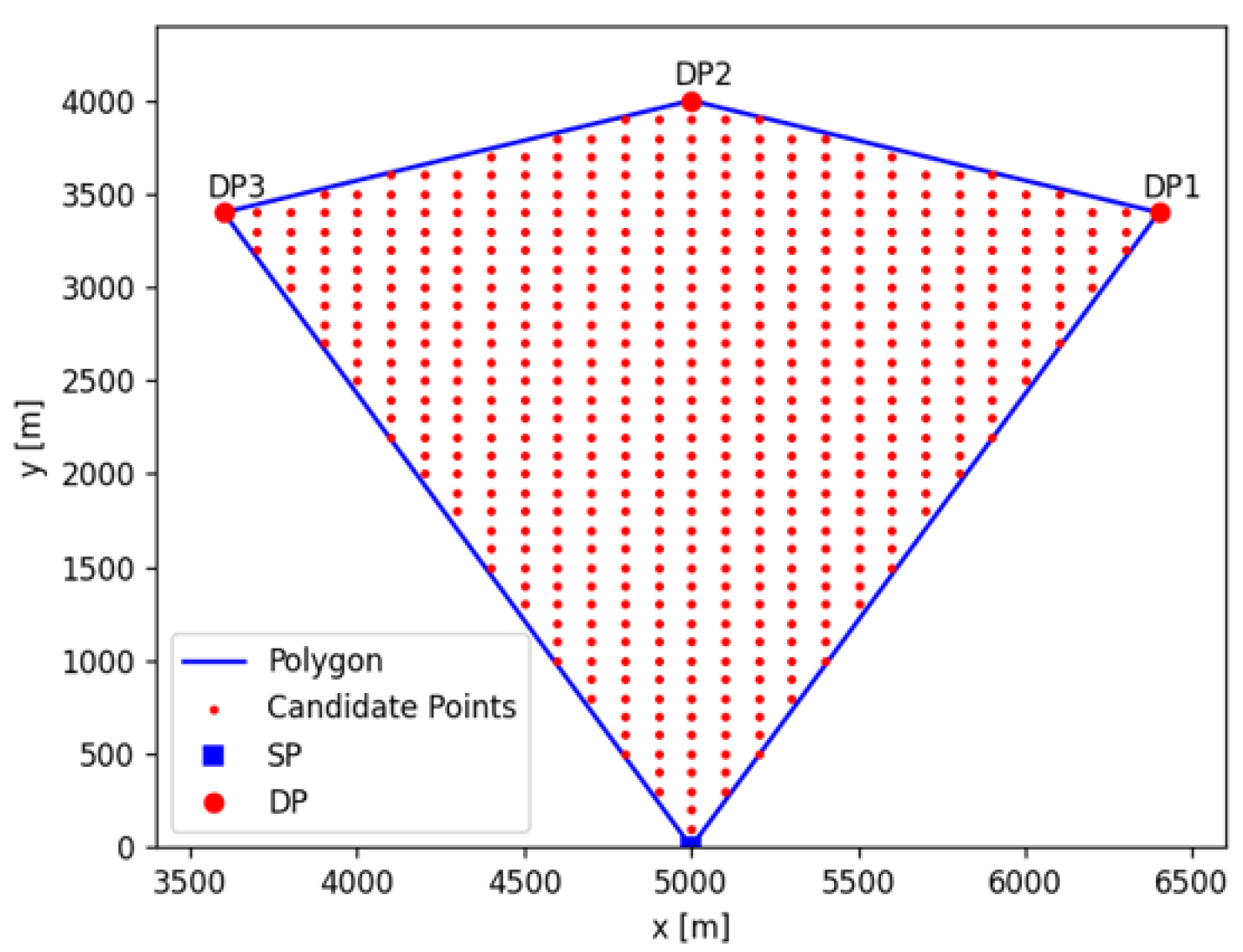
The simulation parameters are shown in Table 1. It is assumed that UAVs replace their batteries each time they return to the SP. UAV operation is limited to daytime, with a maximum operating duration of T O hours from sunrise to sunset. If a UAV exceeds T O hours during flight, the delivery mission is aborted and the UAV automatically returns to the SP. In this study, external disturbances such as wind are not considered, and UAVs are assumed to fly at a constant speed of v. For the basic validation, there are one SP ( n sp = 1 ) and three DPs ( n dp = 3 ). Furthermore, three WPs ( n wp = 3 ) are introduced to improve transmission efficiency. The flight altitude of the UAV is set to 150m. As illustrated in Figure 1, the SP is placed at the edge of the area, and DPs are located within the designated area. Each UAV follows the flight route determined by the algorithm described later, performing both cargo delivery and data communication. The UAVs fly in sequence and conduct data transmission through multi-hop relaying. The maximum communication distance between UAVs is set to 200 m, and each UAV relays data with the farthest UAV located within this maximum communication range.

5.2. Evaluation for Flight Distance

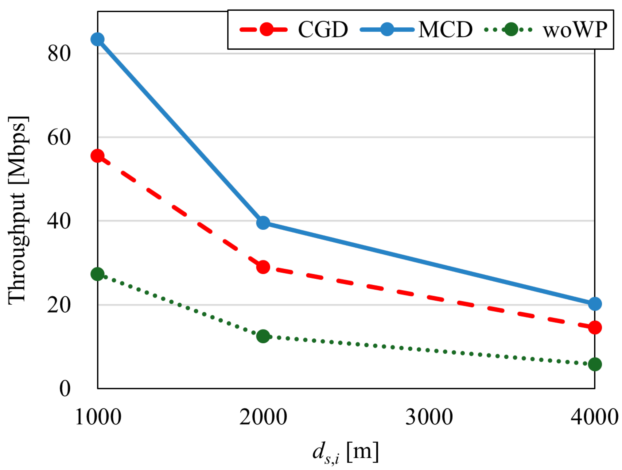
Throughput and battery consumption with respect to the distance between SP and DP are evaluated. SP and DP are arranged as shown in Figure 2, and this configuration is defined as Case 1. From the perspective of SP, DP2 faces forward, and DP1 and DP3 are located in the direction of ± 45 . Here, the distance between SP and the i-th DP is denoted as d s , i . In Case 1, the distance between SP and each DP is set to be the same, d s , 1 = d s , 2 = d s , 3 . Figure 3 shows the average throughput characteristics when d s , i is 1000, 2000, and 4000 m. We compared three methods: two proposed methods (CGD, MCD) and a conventional method. This conventional method does not use the WP (woWP: without Waypoint), but rather the UAV moves in a straight line between the SP and each DP.
From Figure 3, it can be observed that throughput decreases as d s , i increases, and when d s , i doubles, throughput is reduced by half. This is due to the increase in the number of hops. Compared to woWP, MCD improves throughput by at least 14 Mbps, and compared to CGD, it improves by approximately 5 Mbps. The use of WP reduces the number of hops and improves throughput. Next, battery consumption is evaluated. Battery consumption per minute is assumed to be 4.63 W when carrying cargo (outbound) and 1.99 W when unloaded (return) [34], and the total consumption per UAV is calculated for a round trip between SP and each DP.
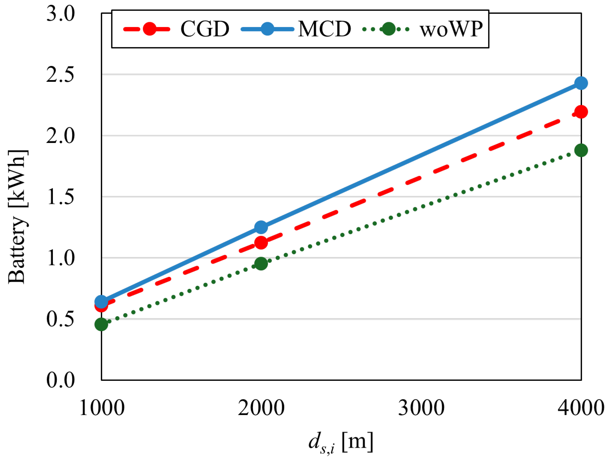
Figure 4 shows the average battery consumption characteristics when d s , i is varied. The results show that woWP consumes the least, while MCD consumes the most. This is because using WP increases the flight distance. Compared with CGD, MCD exhibits nearly the same consumption at d s , i = 1000 m, but at d s , i = 4000 m, MCD consumes approximately 5% more. This is considered to be because MCD prioritizes throughput, which results in longer flight distances through the use of WP.
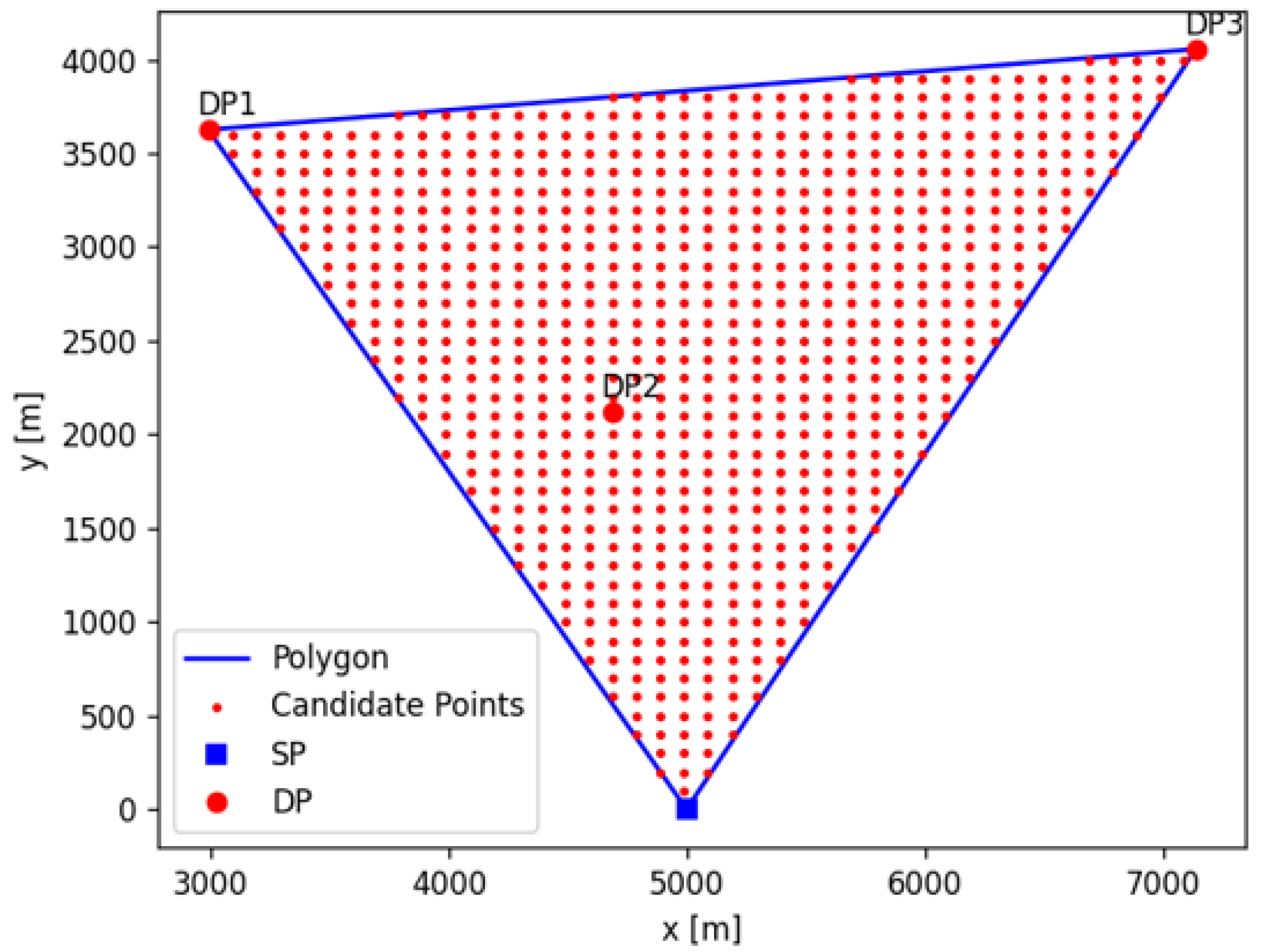
In Section 5.2, all d s , i were the same distance, and the DPs were positioned symmetrically with respect to the SP and DP2. However, in actual UAV operations, DPs are not always positioned equidistantly and symmetrically. We evaluate the cases where the DPs are positioned asymmetrically. Figure 5 shows the SP and each DP in an asymmetric configuration. The DP coordinates are set to p dp = ( ( 2990 ,   3625 ) ,   ( 4690 ,   2120 ) ,   ( 7140 ,   4055 ) ) , and DP2 is positioned inside the polygon formed by the SP, DP1, and DP3.
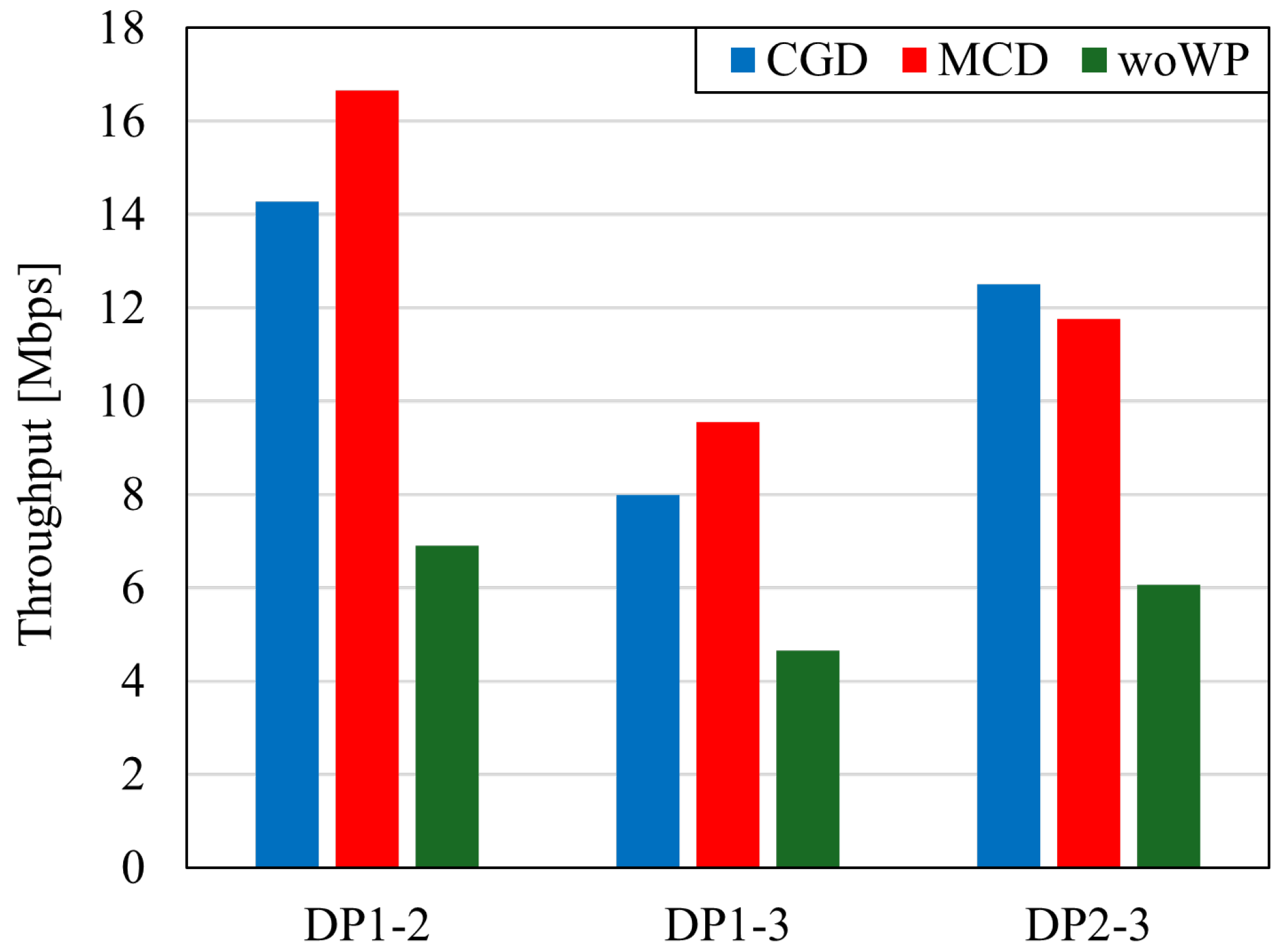
Figure 6 shows the average throughput between DPs. While the throughput with woWP is up to 7 Mbps, using WP exceeds 8 Mbps for all DP pairs. In DP1–2 and DP1–3, MCD achieved higher throughput than CGD, whereas in DP2–3, CGD achieved higher throughput. Since MCD selects WPs to minimize the total path length between DPs, individual paths are not necessarily the shortest. Therefore, depending on the DP placement, using CGD to determine WPs may improve throughput between certain DP pairs. Nevertheless, in terms of total throughput, MCD achieves higher overall performance than CGD.
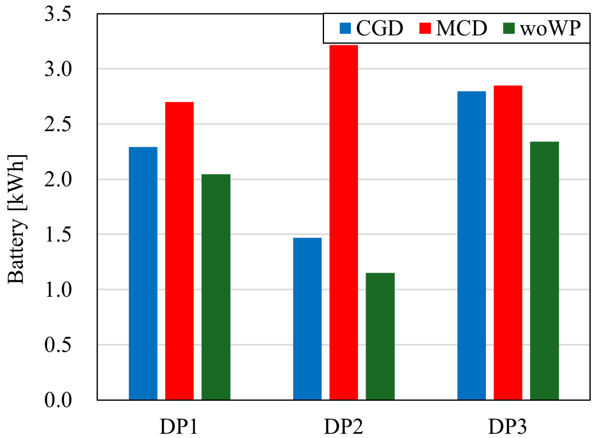
Next, Figure 7 shows battery consumption. Here, battery consumption refers to the average battery usage per destination. As in Section 5.2, woWP exhibits the lowest battery consumption. In particular, when using MCD, the battery consumption of a UAV heading to DP2 is more than twice that of the other methods.
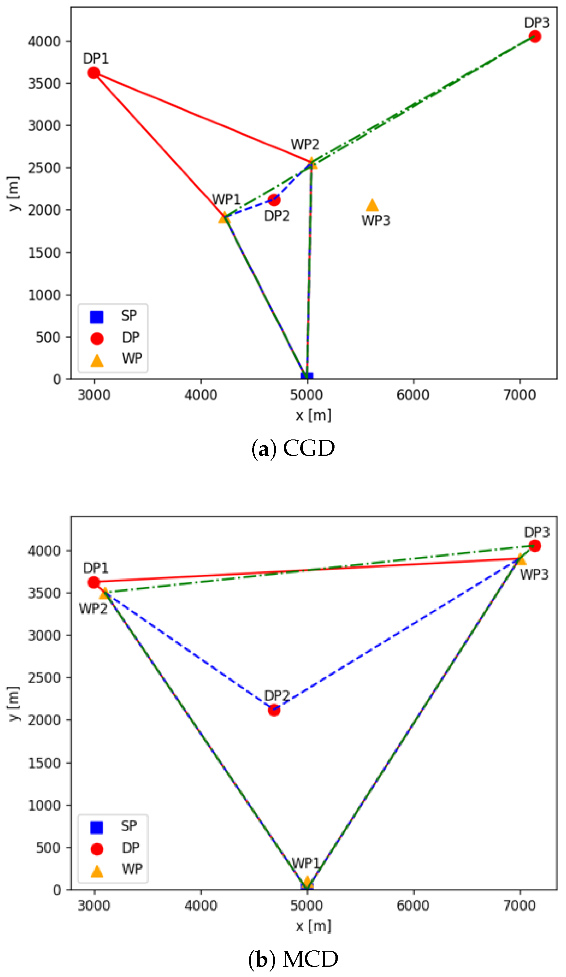
Figure 8 shows the WP placements and flight paths for CGD and MCD. Each colored line in the figure represents the UAV’s flight path via a different DP. Comparing the paths to DP2, we can see that MCD has a longer flight distance. If the DP is close to the SP, setting a flight path to approach other DPs instead of returning to the SP may shorten the communication distance. Also, in Case 2, one of the three WPs is not utilized.

5.3. Evaluation of Positional Relationship of DPs

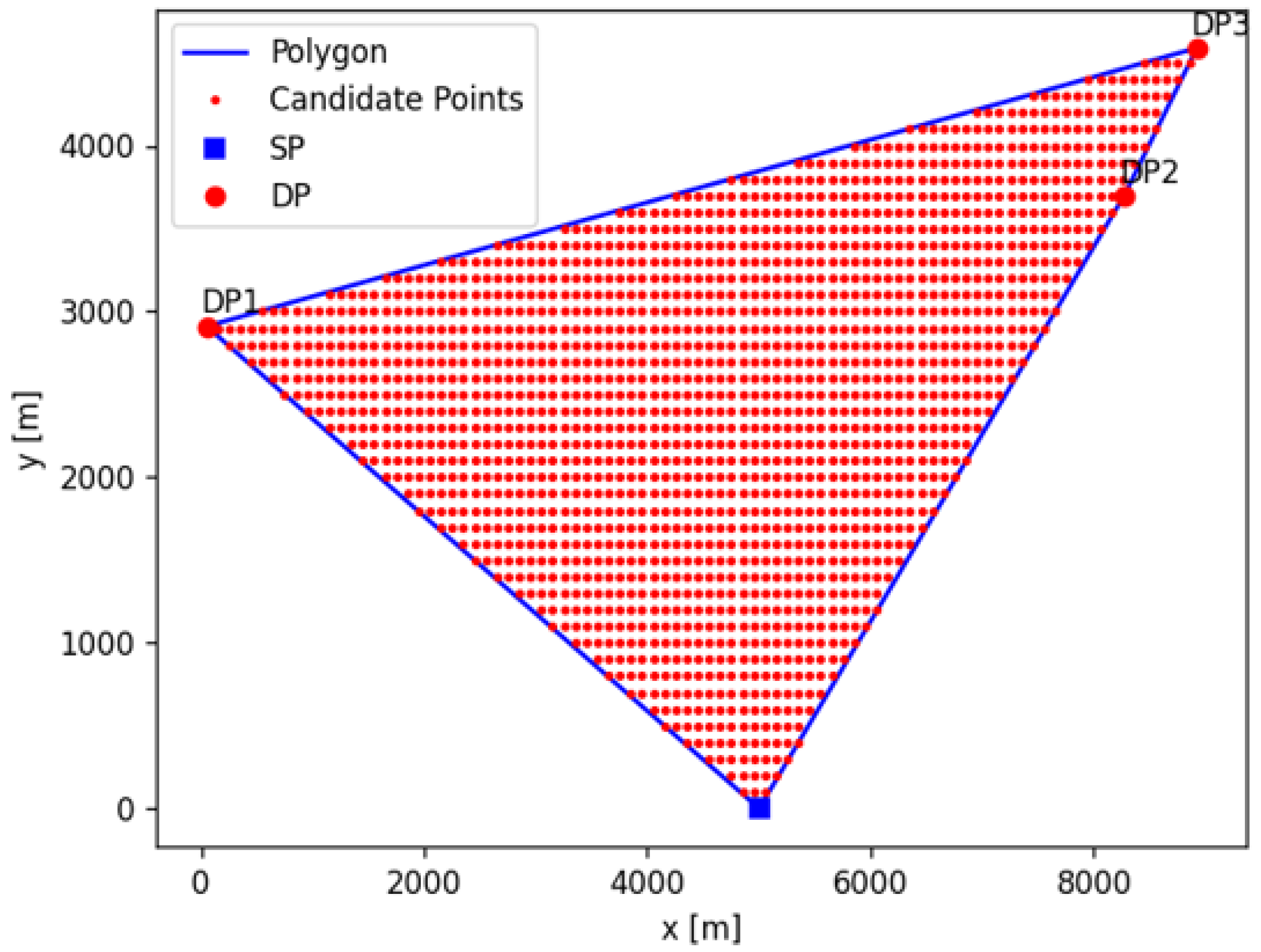
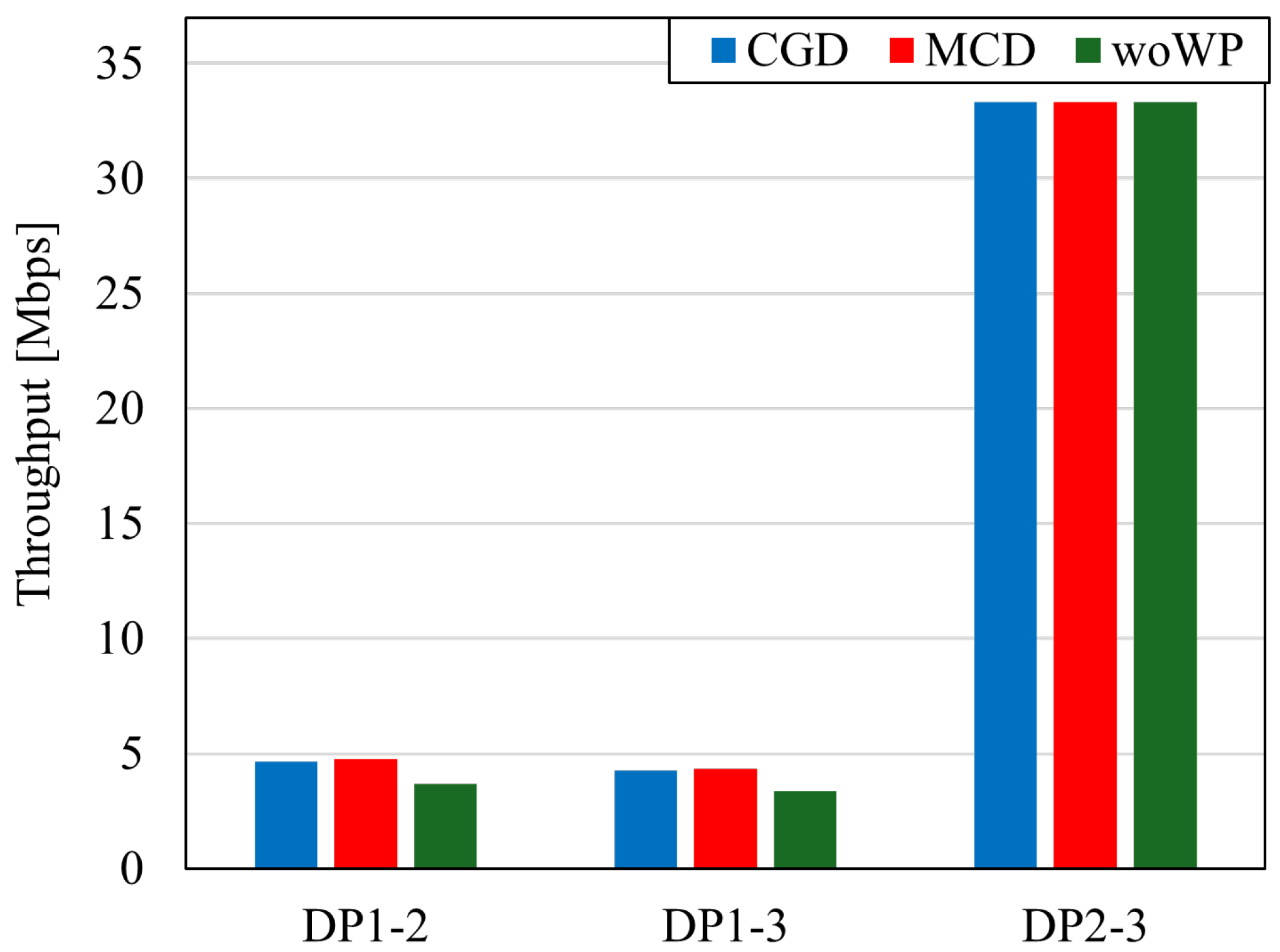
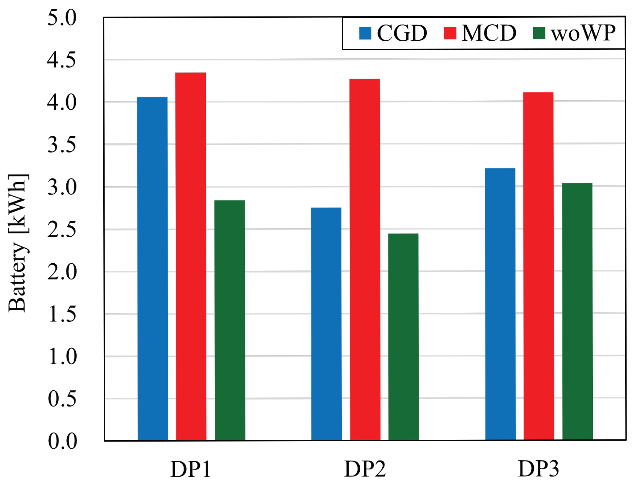
Finally, we evaluate the Case where some DPs are located close to each other (Case 3). Figure 9 shows the DP positions. The DP coordinates are set as p dp = ( ( 50 m , 2910 m ) , ( 8270 m , 3700 m ) , ( 8920 m , 4590 m ) ) . The average throughput characteristics in Case 3 are shown in Figure 10. Since the distance between DP2 and DP3 is shorter than the distances between DP1–2 and DP1–3, the throughput between DP2 and DP3 is higher. For DP2–3, there is no significant difference in throughput among all methods. This is because the short distance between DP2 and DP3 reduces the impact of WP placement. For DP1–2 and DP1–3, the throughput is highest, although using MCD, the improvement is smaller compared to Case 2. Figure 11 shows the battery consumption in Case 3. As in Case 1, MCD results in the highest battery usage. These results indicate that, depending on the DP arrangement, placing waypoints does not necessarily improve throughput. It is also desirable to select the appropriate algorithm between CGD and MCD depending on the position of the DP.

6. Conclusions

This paper proposed a multi-hop relay delivery system using multiple UAVs as an effective communication infrastructure for smart cities, areas where it is challenging to install terrestrial base stations, and during disasters. Specifically, we proposed a WP setting on the flight path for communication between an SP and multiple DPs, and flexibly set the UAV flight path to improve throughput and battery consumption characteristics. As a WP setting method, we proposed a center of gravity determination method and MCD, which places WPs to minimize the communication distance between DPs. Simulation evaluation confirmed that MCD improved average throughput compared to CGD and the conventional method (woWP) that does not use WPs. It was also confirmed that MCD consumes the most battery power. Thus, while this study established several prerequisites and limitations for fundamental verification purposes, it yielded important insights into the fundamental relationship between UAV flight paths, battery constraints, and communication throughput in multi-hop relay environments. Future work must extend to examining elements not previously considered. For example, the battery consumption model used in this study only accounts for power consumption by the UAV motors, neglecting other energy-consuming components such as onboard communication equipment, sensors, and attitude control mechanisms. Furthermore, the communication model assumes idealized conditions, disregarding channel fading, interference, and packet loss. Since these factors could impact communication performance and energy efficiency in real-world environments, future work will involve detailed modeling incorporating these elements.
In addition, while we selected three DPs for demonstration purposes in this study, our heuristic design allows for generalization to other combinations of DPs. In other words, by placing the WP in an area surrounded by DPs, communication paths can be maintained even if the set of DPs changes, reducing the need for reconfiguration. We plan to quantitatively evaluate the robustness of this WP design to changes in the DP combination in future research.

Author Contributions

Conceptualization, H.S. (Hayato Soya), H.S. (Hideya So); methodology, H.S. (Hayato Soya), H.S. (Hideya So); software, K.I.; validation, H.S. (Hayato Soya), K.I.; formal analysis, H.S. (Hayato Soya), H.S. (Hideya So); investigation, H.S. (Hayato Soya), H.S. (Hideya So); resources, H.S. (Hayato Soya); data curation, K.I.; writing—original draft preparation, H.S. (Hayato Soya); writing—review and editing, H.S. (Hayato Soya), H.S. (Hideya So); visualization, K.I.; supervision, H.S. (Hayato Soya), H.S. (Hideya So); project administration, H.S. (Hayato Soya); funding acquisition, H.S. (Hayato Soya). All authors have read and agreed to the published version of the manuscript.

Funding

This research received no external funding.

Data Availability Statement

The raw data supporting the conclusions of this article will be made available by the authors on request.

Conflicts of Interest

The authors declare no conflicts of interest.

References

  1. Li, B.; Fei, Z.; Zhang, Y. UAV communications for 5G and beyond: Recent advances and future trends. IEEE Internet Things J. 2019, 6, 2241–2263. [Google Scholar] [CrossRef]
  2. Mishra, D.; Natalizio, E. A survey on cellular-connected UAVs: Design challenges, enabling 5G/B5G innovations, and experimental advancements. Comput. Netw. 2020, 182, 107451. [Google Scholar] [CrossRef]
  3. Cheng, N.; Xu, W.; Shi, W.; Zhou, Y.; Lu, N.; Zhou, H.; Shen, X. Air-ground integrated mobile edge networks: Architecture, challenges, and opportunities. IEEE Commun. Mag. 2018, 56, 26–32. [Google Scholar] [CrossRef]
  4. Sekander, S. Tabassum and E. Hossain. Multi-Tier Drone Architecture for 5G/B5G Cellular Networks: Challenges, Trends, and Prospects. IEEE Commun. Mag. 2018, 56, 96–103. [Google Scholar] [CrossRef]
  5. Athanasiadou, G.E.; Batistatos, M.C.; Zarbouti, D.A.; Tsoulos, G.V. LTE Ground-to-Air Field Measurements in the Context of Flying Relays. IEEE Wirel. Commun. 2019, 26, 12–17. [Google Scholar] [CrossRef]
  6. Mozaffari, M.; Kasgari, A.T.Z.; Saad, W.; Bennis, M.; Debbah, M. Beyond 5G with UAVs: Foundations of a 3D Wireless Cellular Network. IEEE Trans. Wirel. Commun. 2019, 18, 357–372. [Google Scholar] [CrossRef]
  7. Cai, Y.; Wei, Z.; Hu, S.; Ng, D.W.K.; Yuan, J. Resource allocation for power-efficient IRS-Assisted UAV communications. In Proceedings of the 2020 IEEE International Conference on Communications Work, ICC Work, Dublin, Ireland, 7–11 June 2020. [Google Scholar]
  8. Chaalal, E.; Senouci, S.-M.; Reynaud, L. A New Framework for Multi-Hop ABS-Assisted 5G-Networks with Users’ Mobility Prediction. IEEE Trans. Veh. Technol. 2022, 71, 4412–4427. [Google Scholar] [CrossRef]
  9. Bae, J.; Sohn, K.Y.; Lee, H.; Lee, H.; Lee, H. Structure of UAV-Based Emergency Mobile Communication Infrastructure. In Proceedings of the 2021 International Conference on Information and Communication Technology Convergence (ICTC), Jeju Island, Republic of Korea, 20–22 October 2021; pp. 634–636. [Google Scholar]
  10. Abubakar, A.I.; Mollel, M.S.; Onireti, O.; Ozturk, M.; Ahmad, I.; Asad, S.M.; Sambo, Y.; Zoha, A.; Hussain, S.; Imran, M.A. Coverage and throughput analysis of an energy efficient UAV base station positioning scheme. Comput. Netw. 2023, 232, 109854. [Google Scholar] [CrossRef]
  11. Saif, A.; Dimyati, K.; Noordin, K.A.; Alsamhi, S.; Haubani, A. Multi-UAV and SAR collaboration model for disaster management in B5G networks. Internet Technol. Lett. 2021, 7, e310. [Google Scholar] [CrossRef]
  12. Zhang, G.; Yan, H.; Zeng, Y.; Cui, M.; Liu, Y. Trajectory Optimization and Power Allocation for Multi-Hop UAV Relaying Communications. IEEE Access 2018, 6, 48566–48576. [Google Scholar] [CrossRef]
  13. Hamza, A.S.; Khalifa, S.S.; Hamza, H.S.; Elsayed, K. A survey on inter-cell interference coordination techniques in OFDMA-based cellular networks. IEEE Commun. Surveys Tuts. 2013, 15, 1642–1670. [Google Scholar] [CrossRef]
  14. So, H. Evaluation of radio interference areas by flight path and antenna directivity of UAV in urban area. In Proceedings of the 2024 IEEE 100th Vehicular Technology Conference (VTC2024-Fall), Washington, DC, USA, 1–5 October 2024. [Google Scholar]
  15. Wei, X.; Mei, W.; Chen, Z. Hybrid Linear and Nonlinear Uplink Cooperative Interference Cancellation for Cellular-Connected UAV. In Proceedings of the 2024 IEEE 99th Vehicular Technology Conference (VTC2024-Spring), Singapore, 24–27 June 2024; pp. 1–5. [Google Scholar]
  16. So, H.; Maruta, K. Directional antenna with lightweight metamaterial reflector for UAV-based networks. IEEE Access 2021, 9, 78735–78741. [Google Scholar] [CrossRef]
  17. So, H.; Maruta, K. Sector design using multiband antenna with metamaterial reflector for cellular UAV system. IEEE Access 2022, 10, 4924–4933. [Google Scholar] [CrossRef]
  18. Chen, Y.; Feng, W.; Zheng, G. Optimum placement of UAV as relays. IEEE Commun. Lett. 2018, 22, 248–251. [Google Scholar] [CrossRef]
  19. Li, L.; Chang, T.-H.; Cai, S. UAV positioning and power control for two-way wireless relaying. arXiv 2019, arXiv:1904.08280. [Google Scholar] [CrossRef]
  20. So, H. Optimal relay positions in cooperative UAV relay networks. IEICE Commun. Express (ComEX) 2025, 14, 287–291. [Google Scholar] [CrossRef]
  21. Burhanuddin, L.A.B.; Liu, X.; Deng, Y.; Elkashlan, M.; Nallanathan, A. Inter-Cell Interference Mitigation for Cellular-Connected UAVs Using MOSDS-DQN. IEEE Trans. Cogn. Commun. Netw. 2023, 9, 1596–1609. [Google Scholar] [CrossRef]
  22. Mei, W.; Zhang, R. Cooperative Downlink Interference Transmission and Cancellation for Cellular-Connected UAV: A Divide-and-Conquer Approach. IEEE Trans. Commun. 2020, 68, 1297–1311. [Google Scholar] [CrossRef]
  23. Lv, C.; Ren, Y.; Li, X.; Wang, P.; Du, Z.; Ma, G.; Chi, H. Unmanned Aerial Vehicle-Assisted Sparse Sensing in Wireless Sensor Networks. IEEE Wirel. Commun. Lett. 2023, 12, 977–981. [Google Scholar] [CrossRef]
  24. Horiuchi, M.; Nishiyama, H.; Kato, N.; Ono, F.; Miura, R. Throughput maximization for long-distance real-time data transmission over multiple UAVs. In Proceedings of the IEEE ICC, Kuala Lumpur, Malaysia, 23–27 May 2016; pp. 1–6. [Google Scholar]
  25. Pan, W.; Lv, N.; Hou, B.; Ren, Z. Resource Allocation and Outage Probability Optimization Method for Multi-Hop UAV Relay Network for Servicing Heterogeneous Users. IEEE Trans. Netw. Sci. Eng. 2024, 11, 2769–2781. [Google Scholar] [CrossRef]
  26. Chen, Y.; Zhao, N.; Ding, Z.; Alouini, M.-S. Multiple UAVs as relays: Multi-hop single link versus multiple dual-hop links. IEEE Trans. Wirel. Commun. 2018, 17, 6348–6359. [Google Scholar] [CrossRef]
  27. Hosseinalipour, S.; Rahmati, A.; Dai, H. Interference Avoidance Position Planning in Dual-Hop and Multi-Hop UAV Relay Networks. IEEE Trans. Wirel. Commun. 2020, 19, 7033–7048. [Google Scholar] [CrossRef]
  28. Kim, T.; Qiao, D. Energy-Efficient Data Collection for IoT Networks via Cooperative Multi-Hop UAV Networks. IEEE Trans. Veh. Technol. 2020, 69, 13796–13811. [Google Scholar] [CrossRef]
  29. Ding, R.; Chen, J.; Wu, W.; Liu, J.; Gao, F.; Shen, X. Packet Routing in Dynamic Multi-Hop UAV Relay Network: A Multi-Agent Learning Approach. IEEE Trans. Veh. Technol. 2022, 71, 10059–10072. [Google Scholar] [CrossRef]
  30. Fan, J.; Cui, M.; Zhang, G.; Chen, Y. Throughput Improvement for Multi-Hop UAV Relaying. IEEE Access 2019, 7, 147732–147742. [Google Scholar] [CrossRef]
  31. Lai, C.-C.; Bhola; Tsai, A.-H.; Wang, L.-C. Adaptive and Fair Deployment Approach to Balance Offload Traffic in Multi-UAV Cellular Networks. IEEE Trans. Veh. Technol. 2023, 72, 3724–3738. [Google Scholar] [CrossRef]
  32. Matar, A.S.; Shen, X. Joint Subchannel Allocation and Power Control in Licensed and Unlicensed Spectrum for Multi-Cell UAV-Cellular Network. IEEE J. Sel. Areas Commun. 2021, 39, 3542–3554. [Google Scholar] [CrossRef]
  33. Zhou, S.; Liu, X.; Tang, B.; Tan, G. Handover and Coverage Analysis in 3-D Mobile UAV Cellular Networks. IEEE Internet Things J. 2024, 11, 29911–29925. [Google Scholar] [CrossRef]
  34. DJI. DJI Flycart 30 Spec. Available online: https://www.dji.com/jp/flycart-30/specs (accessed on 26 October 2025).
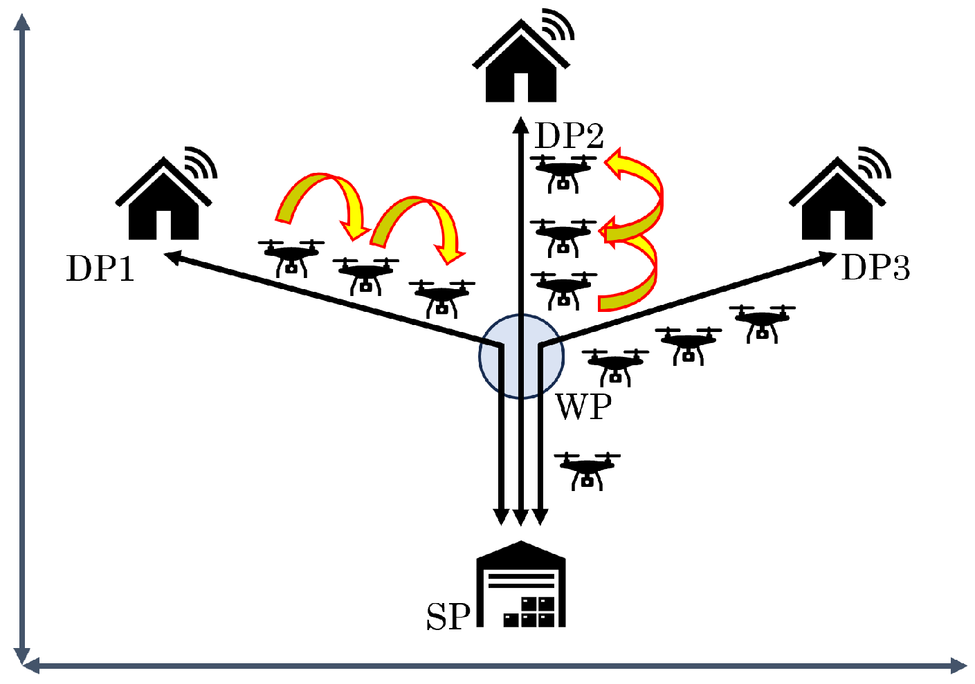
Figure 1. Flight model of UAV.
Drones 09 00751 g001
Figure 2. Polygon and WP candidates in Case 1.
Drones 09 00751 g002
Figure 3. Average throughput for each d s , i .
Drones 09 00751 g003
Figure 4. Average battery consumption for each d s , i .
Drones 09 00751 g004
Figure 5. Polygon and WP candidates in Case 2 (DP is close SP).
Drones 09 00751 g005
Figure 6. Average throughput in Case 2.
Drones 09 00751 g006
Figure 7. Average battery consumption in Case 2.
Drones 09 00751 g007
Figure 8. Flight paths when using each method in Case 2.
Drones 09 00751 g008
Figure 9. Polygon and WP candidates in Case 3 (DP2 is close to DP3).
Drones 09 00751 g009
Figure 10. Average throughput in Case 3.
Drones 09 00751 g010
Figure 11. Average battery consumption in Case 3.
Drones 09 00751 g011
Table 1. Simulation parameters.
ParameterValue
Area d area × d area 10 × 10   km 2
Number of SPs n sp 1
Position of SP ( x , y ) (5000 m, 0 m)
Number of DPs n dp 3
Number of WPs n wp 3
The flight altitude of the UAV z UAV 150 m
Velocity of UAVv15 km/h
Operating time of UAV/day T o 8 h
Battery consumption per minuteloaded C lo 4.63 W
not loaded C un 1.99 W
Maximum throughput
of one link
C max 200 Mbps
Maximum communication
distance
d max 200 m
Disclaimer/Publisher’s Note: The statements, opinions and data contained in all publications are solely those of the individual author(s) and contributor(s) and not of MDPI and/or the editor(s). MDPI and/or the editor(s) disclaim responsibility for any injury to people or property resulting from any ideas, methods, instructions or products referred to in the content.