Review

Mapping the Integration of Urban Air Mobility into the Built Environment: A Bibliometric Analysis and a Scoping Review

by
Ludovica Maria Campagna
*,
Francesco Carlucci
,
Francesco Fiorito
*,
Erika Rosella Marinelli
,
Michele Ottomanelli
and
Mario Marinelli
Department of Civil, Environmental, Land, Building Engineering and Chemistry (DICATECh), Polytechnic University of Bari, 70125 Bari, Italy
*
Authors to whom correspondence should be addressed.
Drones 2025, 9(10), 692; https://doi.org/10.3390/drones9100692
Submission received: 15 September 2025 / Revised: 6 October 2025 / Accepted: 8 October 2025 / Published: 10 October 2025
(This article belongs to the Special Issue Urban Air Mobility Solutions: UAVs for Smarter Cities)

Abstract

Urban Air Mobility (UAM) has the potential to revolutionize urban transportation, largely with the deployment of Unmanned Aerial Vehicles (UAVs), commonly known as drones. After an initial stage focused on technology requirements, research is now shifting toward investigating operational requirements, which are unavoidably affected by urban characteristics. This study aims to explore the implementation of UAM services within urban environments by mapping the current scientific landscape from a city-focused perspective. Following a systematic search procedure, a bibliometric analysis was conducted on studies published between 2010 and 2024, examining over 350 articles that address UAM and urban-related topics. Trends in publication volume and scientific impact were analysed, along with influential manuscripts, collaborations, and leading countries in the field. Through a keyword co-occurrence analysis, five main research themes were identified: air traffic management, risk assessment, environmental factors (wind and noise), and vertiport location. These themes were further explored through a scoping review to assess current research and emerging directions. The findings highlight that urban characteristics are not just operational constraints but also fundamental elements that shape UAM strategies, influencing UAV path planning, safety, environmental constraints, and infrastructure design. Future research directions include the development of urban digital twins, comprehensive urban spatial databases, and multi-objective optimization frameworks to support the effective implementation of UAM into cities.

1. Introduction

Urban Air Mobility (UAM) represents a new frontier in air transportation systems, which could provide significant advancements in the efficient, safe, and sustainable transportation of passengers and cargo within the urban environment [1]. Indeed, given the predicted increase in urbanization (at a rate of 3% per decade [1]), the pressure on urban transport networks is expected to rise, thus requiring rethinking of traditional transportation systems to avoid traffic congestion. In this context, technological advancements in the aerospace industry have laid the foundation for a paradigm shift for intra-city and urban transportation [2]: recent progress in distributed electric propulsion [3] and battery energy storage [4] has enabled vertical take-off and landing (eVTOL) of aircraft to become a viable option for the implementation of Urban Air Mobility. The concept of eVTOL was first introduced by NASA in 2010 [5], resulting in the major aerospace companies working on its development since 2011. These vehicles have been mainly conceived for transportation within urban areas, and in the future, they are expected to be characterized by full autonomy (without the pilot’s involvement) [6]. To achieve these ambitions, aircraft design and configuration become crucial for effective implementation of UAM services, making this topic an extensive field of research [7]. This new paradigm allows for a multitude of use cases [8], including not only passenger and cargo transportation, but also military and defence purposes, emergency services and logistics [9].
UAM is expected to produce many benefits for cities. For instance, focusing on passenger transport, some studies revealed that it would reduce urban travel time, not only for the users [10], but also for those taking traditional transport services, due to an overall growth in efficiency of the urban travel network [11]. In addition, the introduction of these services would create a new market, increasing job opportunities. However, it is worth noting that the feasible environmental sustainability of this service is still debated by scholars [12], accounting for a small amount of literature on this topic [13].
To date, research has been mainly focused on aircraft technologies, but more recent studies are now addressing the challenges of service implementation, which are unavoidably linked to the urban environment in which the service will operate. In this context, Unmanned Aerial Vehicles (UAVs), commonly known as drones, have gained increasing attention due to their versatility, mobility, and flexibility, which make them suitable for a wide range of applications, exhibiting the potential to enhance UAM services. UAVs and eVTOLs show significant potential in UAM applications, which range from last-mile travel (LMT) for passengers to last-mile delivery (LMD) for parcels, logistics or emergency response. More in detail, UAVs can be defined as aircraft guided by remote control or onboard computers. These vehicles can be classified based on the structure of their lift-producing surfaces, including fixed-wing, single rotor, multi-rotor and lift and cruise/vectored thrust, which combine the advantages of both fixed-wing and rotor-based designs [14]. On the one hand, fixed-wing vehicles offer higher speeds and longer coverage, while rotary-motor vehicles offer hovering and flight precision in reduced spaces, although exhibiting shorter battery life. Representing a balance between them are the convertible fixed-wing UAVs, which combine hover capabilities with cruise flight [15]. Overall, UAVs are typically smaller and operate at lower latitudes, allowing them to be used for inspection, delivery, and surveillance. By contrast, eVTOLs are a specific category of electrical aircraft designed for vertical take-off and landing, which offer higher payload capacity and longer operational range. As a result, they are suitable for transporting passengers and heavier cargo. Furthermore, as UAV research advances, an increasing number of potential applications are emerging that go beyond passenger mobility, encompassing multifunctional operations. For instance, these include the transport of larger and more diverse payloads [16], which can be carried either by attaching objects directly to the UAV or by suspending packages via cables, an approach that clearly requires careful consideration of obstacles [17].
Overall, although they can potentially lead to a revolution in urban transportation, their effective implementation faces multiple challenges [18], including the regulatory environment, air traffic management, noise pollution, weather risks, environmental impact, infrastructure requirements, safety and security, and social acceptance [19]. In recent years, the scientific community has been making an effort to address these challenges, although they clearly cover a multitude of topics, which belong to very different research expertise [20]. Consequently, these problems are often treated separately, each addressed in its area of research, although it is undeniable that the successful implementation of UAM requires a holistic and integrated approach involving all the network components [21]. Indeed, scholars agree that proper integration within the city represents a crucial factor for UAM services [18].
While UAM is attracting the attention of scholars, it remains an emerging topic, resulting in a lack of comprehensive assessments on the research landscape. Indeed, previous studies are mainly focused on the evaluation of specific research topics, like the evaluation of wind conditions for safe UAM operations [22,23], noise pollution [24,25,26], air traffic management [27], ground-based infrastructure [28], and vertiport design [29,30]. While these review manuscripts undoubtedly offer significant contributions, they appear mainly monodisciplinary, as they focus on detailed examinations of specific research topics but rarely explore their interconnections. This limitation is often due to the wide diversity of the subjects involved, which draw on very different fields of expertise and make cross-disciplinary assessments more challenging. Moreover, although broader review studies exist, they are mostly narrative in nature, focusing on the main challenges associated with UAM implementation and lacking a structured review methodology [18,20,31,32]. The UAM scene was outlined five years ago by Straubinger et al. [18], who provided an overview for the introduction of UAM, gathering the main results from different fields in the UAM research community. Then, Cohen et al. offered an early descriptive narrative on UAM, reconstructing its historical evolution through a multi-method qualitative approach that included interviews with key industry stakeholders, aiming to identify major barriers to implementation [19]. The regulatory and social challenges related to the implementation of aerospace innovations in urban environments are also discussed by Zewde et al. [21] through a narrative review and by Wild et al. [31] through qualitative synthesis. However, both studies lack a transparent and replicable methodological protocol, which limits the generalizability of their findings. Indeed, although these studies provide valuable insights into the topic, they do not employ a structured and reproducible methodology capable of systematically capturing the current state of academic research, identifying key actors, focus areas, and evolving themes in relation to the issues previously outlined. However, given the rapid growth of this emerging field, the adoption of structured methods is essential for systematically evaluating research outputs, trends, and emerging topics, thereby understanding the direction of scientific inquiry in relation to previously identified challenges. In this context, bibliometric analysis appears to be a promising approach to shed light on the field’s growth, development, key collaborations, and global impact [33], while also serving as a valuable basis for a scoping review. Overall, the scoping studies aim to map the key concepts of a research field, thus offering a comprehensive breadth of the available literature [34].
The present study aims to address these research gaps by offering a broader perspective on the state of the art of research on UAM integration within urban environments. By combining a bibliometric analysis and a scoping review, the study aims to address these research questions, providing a systematic and structured overview of the current state of research on UAM integration within the built environment, with a particular focus on UAVs implementation. Going beyond existing reviews, our study adopts a structured and integrative approach that allows us to map the UAM research landscape as a whole. Indeed, the scoping methodology is particularly well suited to our objective of exploring how UAM is being integrated into the built environment, which is supposed to be fragmented across multiple domains. Through this methodology, we not only identify key research areas but also examine their interconnections, shifting from fragmented and topic-specific analyses to a comprehensive overview of the field. In addition to this methodological contribution, our work also introduces a different perspective by explicitly framing UAM within the context of its integration into the built environment. More in detail, this study seeks to answer the following research questions:
  • How can the research landscape be mapped in terms of publications and citations to identify the most influential sources, leading countries, and international collaborations?
  • What are the main research themes emerging in this field?
  • How is the research on UAM integration evolving, and what are the future directions?
The manuscript is structured as follows: Section 2 describes the methodology adopted to conduct the literature search, while Section 3 provides the main results of both bibliometric analysis and scoping review, with a detailed discussion given in Section 4. Finally, the main conclusions are summarized in Section 5.

2. Methods

The present review has been conducted following the guidelines provided by Arksey and O’Malley [34], who developed useful guidance for conducting a scoping review. Accordingly, a systematized literature search has been carried out in line with the PRISMA guidelines [35] to select the sample of manuscripts to be reviewed, based on the stated research aim. Indeed, a proper search strategy for manuscripts is essential as it affects the body of literature on which the review is built. Then, a bibliometric analysis has been performed, using the VOSviewer software (version 1.6.20) [36] and the R-based tool Biblioshiny [37,38]. Among the analyses conducted, the keyword co-occurrence analysis was employed to identify the main research themes, which then became the focus of the scoping review. The entire methodological process is summarized in Figure 1 and further detailed in the following subsections.

2.1. Search Strategy

The main objective of this work was to explore the current state of research on Urban Air Mobility, with a specific focus on its integration into the built environment. Starting from the research scope, the search criteria have been established, adopting Scopus as the search database, which is widely regarded as the most reliable database alongside Web of Science [39]. Numerous studies have extensively compared these two databases, revealing that Scopus offers broader coverage of journals and scientific production than Web of Science [40,41]. Moreover, Scopus features a quicker indexing system compared to Web of Science, enabling the retrieval of more recent publications by continuously updating its repository [42]. Accordingly, the present analysis was performed by gathering manuscripts retrieved solely from Scopus database, without compromising the validity or integrity of the sample.
A set of keywords has been selected to retrieve articles, referred both to the UAM and the built environment research topics, combined into the following Boolean search query: (TITLE-ABS-KEY (“urban air mobility” OR “UAM” OR “urban air transportation” OR “urban aviation” OR “e-vtol*” OR “airtaxi*”) AND TITLE-ABS-KEY (“infrastructur*” OR “urban area” OR “urban environment” OR “urban development” OR “urban planning” OR “building*” OR “city planning” OR “land use planning” OR “ground infrastructur*” OR “urban design”)). As a result, a sample of 771 manuscripts was retrieved and then refined based on the selected inclusion criteria:
  • Only English-written papers were included.
  • The publication period was restricted to 2010–2024. We selected 2010 as the starting year since it marks the year of reintroduction of on-demand UAM services [19]. We chose 2024 as the end year to avoid data bias, since we are still in the year of 2025 at the time of writing.
  • Articles from the following subject areas were excluded to remove unrelated studies: Medicine, Health Professions, Pharmacology, Toxicology and Pharmaceutics were excluded.
Further details of the search string adopted to conduct the literature review are provided as Supplementary Materials. The resulting sample involved 634 articles, which were then subjected to a screening process based on titles and abstracts to collect relevant studies. During the screening process, articles related to aircraft design, aircraft performance and operational requirements, user perception, and demand modelling were excluded. More in detail, studies dealing with the mathematical modelling of demand were omitted, since they were not closely related to the urban context, as well as those dealing with user perception when they focused only on the abstract perception of UAM without any connection to the city. Following this process, 331 articles were selected to conduct the review. Lastly, based on these selected manuscripts, a forward citation search has been conducted to identify further studies on the same topics. As a result, 30 papers were retrieved and evaluated based on the same screening criteria, leading to the inclusion of 20 additional articles. Thus, the total number of manuscripts included in the review was 351.

2.2. Bibliometric and Scoping Analyses

The selected manuscripts were used to conduct a bibliometric analysis, which helps scholars map the research field through a systematic, transparent, and reproducible review process [33]. The analyses have been performed through two main tools: the R-based Biblioshiny tool [37,38] and the VOSviewer software [36]. Biblioshiny is a web-based graphical interface powered by Bibliometrix, which enables a multitude of bibliometric analyses, directly from the raw database. In detail, in this work, the tool allows for the exploration of the main characteristics of the reviewed body of literature, including publication and citation trends, main published document types, most productive sources in terms of published documents, and most impactful manuscripts. Moreover, the most productive and impactful countries were identified. It is important to specify that the citation data reflect the status at the time of analysis, conducted on 28 March. To ensure the quality of visualization, the outputs of Biblioshiny were further elaborated in tables or figures created with Microsoft Excel. In addition, more insights into collaboration patterns and emerging research trends were evaluated using VOSviewer. VOSviewer is a user-friendly tool which allows users to visualize bibliometric networks, adopting a distance-based approach [43]. These networks can consist of multiple nodes, which are positioned within the network in a two-dimensional space, based on the similarities: the closer the nodes, the more strongly they are related. To account for variations in connections between nodes, a normalization approach is usually adopted. In this work, the default association strength is adopted as a normalization method. Moreover, each node is assigned to a cluster, which is visualized with a different color in the map. Firstly, the countries’ collaborations were visualized through a network map. Then, a keyword co-occurrence analysis was performed to identify and map the most frequently recurring keywords, providing insights into the thematic evolution of the research domain. Indeed, based on the keyword co-occurrence analysis, the main research themes in the field were identified, serving as the focus of the scoping review. More specifically, the main thematic categories were identified and then analysed to point out the main research streams and research gaps. In this framework, it is important to clarify that a quality assessment of the reviewed studies was not conducted, as the main purpose of a scoping study is to explore the breadth of the literature by mapping evidence and prospects, rather than critically evaluating the studies [34].

3. Results

3.1. Publication and Citation Trends

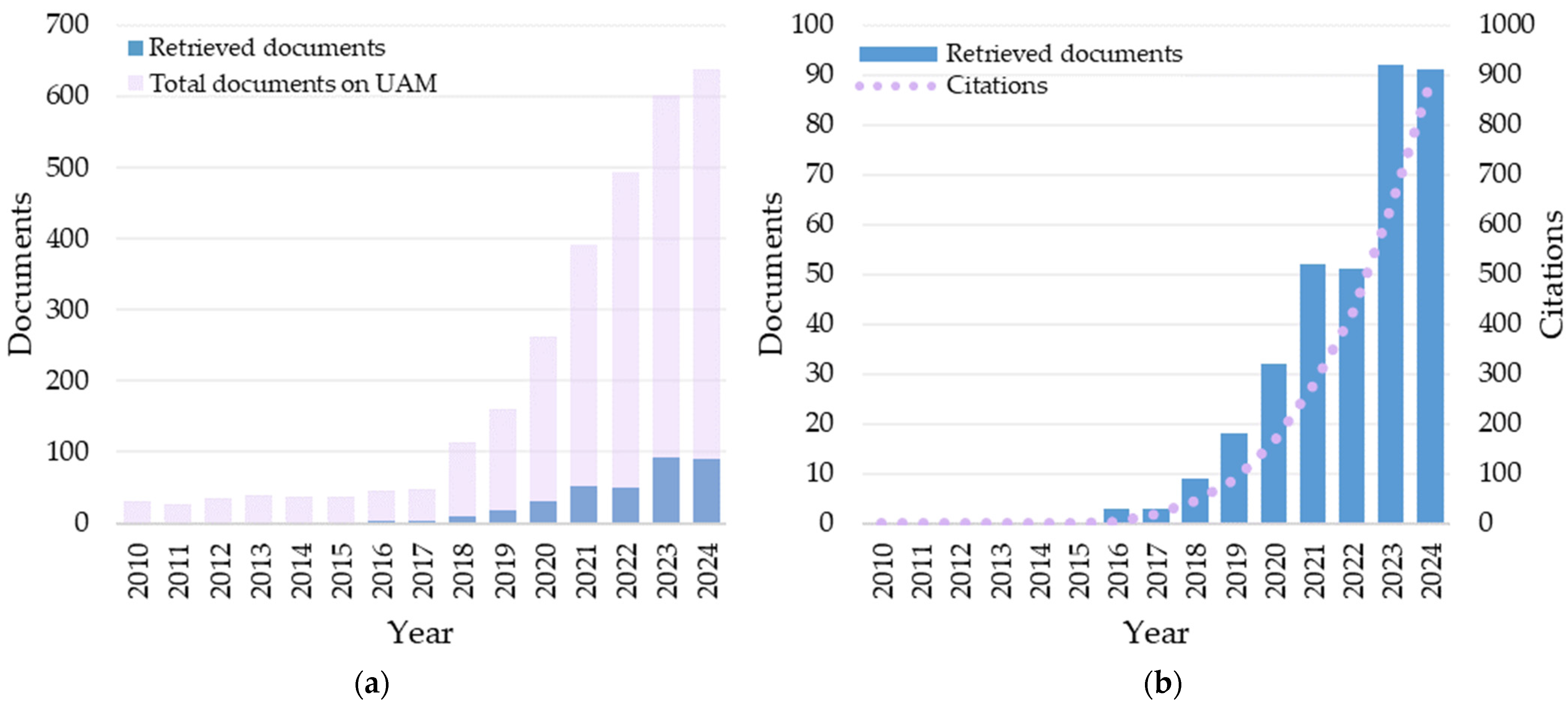
Figure 2 provides an overview of the publication metrics, showing the evolution of research on UAM in relation to the built environment, in terms of both scientific production and academic impact. The number of documents published per year is illustrated in Figure 2a, where it is compared to the overall volume of publications on UAM. This volume was identified through a further search in the Scopus database, using the keywords “UAM” OR “Urban Air Mobility” and applying the same inclusion criteria described in the methodology: English-written papers published between 2010 and 2024, with the exclusion of the unrelated subject areas. Figure 2b more distinctly shows the number of papers published annually, along with the number of citations by year, which provides insights into the scientific impact of the topic.
Overall, the graphs reveal that UAM is a research area of recent development, with studies related to the built environment representing only a limited portion of the broader UAM research topic, accounting for just 12%. Looking at Figure 2a, during the early research stages (from 2010 to 2015), research concerning the integration into the built environment was almost absent, with no manuscripts released up to 2015. Meanwhile, during the same period, the total number of articles on UAM appeared limited but steady over time, averaging 35 papers per year. The reason behind this could be that research was primarily focused on technological advancements of UAM aircraft, thus being mainly related to the aeronautical field. Then, over the period of 2016–2021, the number of publications began to exponentially increase, reaching over 52 manuscripts published in 2021. This growth reflects a steady increase in the total number of UAM-related publications, with research on the built environment consistently representing around 10% of the total publication volume. Since 2021, general research on UAM has continued its linear rise, while scientific production specifically related to the built environment has experienced exponential growth, doubling the number of published articles from 2023 onward and reaching 15% of the total publication volume on UAM.
Looking at Figure 2b, the annual citation trend appears to reflect the publication trend, with the 351 reviewed manuscripts attracting a total of 2528 citations, which occurred during the second period of the 15-year analysis. The absence of articles in the first five-year period resulted in a lack of citations. However, as soon as the first articles were published in 2016, they immediately attracted interest, which has continued to grow without interruption until today. Indeed, the first citations appeared in 2016 and began to increase exponentially from 2017 onwards, reaching 883 citations by 2024. Although it remains an emerging topic in its early stages, such a citation trend demonstrates the significant impact it currently holds.
Looking more closely at the publication trend, Table 1 reports the number of publications per year together with their Annual Growth Rate (AGR), calculated according to Equation (1).
A G R = E n d V a l u e F i r s t V a l u e F i r s t V a l u e × 100
Starting from 2016, the first year in which publications appeared, the trend shows some fluctuations: after a peak in the early years (2018 and 2019), growth generally remained positive, with only two slight declines in 2022 (−1.9%) and 2024 (−1.1%). Overall, the average AGR over the nine years of publications is positive, accounting for 64.7%, while the Compound Annual Growth Rate (CAGR) over the same period was 53%, highlighting the variability in annual growth, with some years experiencing very high increases and others slight negative growth.

3.2. Document Types and Leading Sources

Research outputs on UAM related to the built environment are found to be published in different document types, the majority of which are available in open-access format, thus facilitating the research dissemination. The data analysis conducted using Biblioshiny revealed that more than half of the reviewed manuscripts are conference proceedings, accounting for 203 out of 351 articles. The prevalence of conference papers highlights that it remains an emerging but rapidly evolving research topic, where preliminary findings are often disseminated in conference proceedings. This also suggests that this field is still developing, as a relatively smaller proportion of studies have undergone the more rigorous peer-review processes typically associated with journal publications. Specifically, journal articles represent approximately one-third of the reviewed literature (134 out of 351 papers), followed by review papers (8) and book chapters (6). This imbalance has noteworthy implications: while it reflects the dynamism and novelty of the topic, it also suggests that the overall maturity and robustness of the research are still limited. Accordingly, future progress will likely depend on a growing share of journal articles that can provide more reliable contributions.
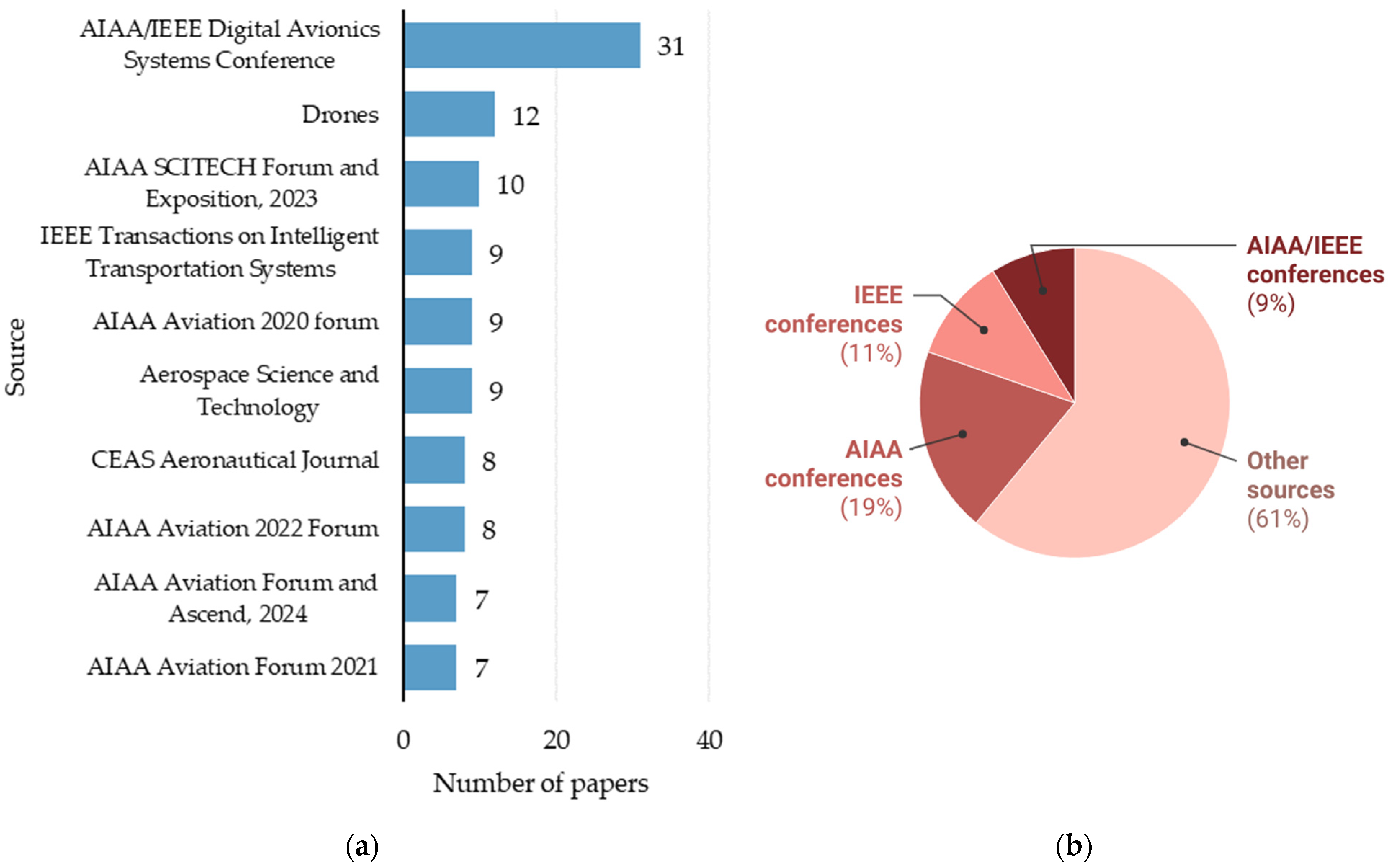
Figure 3a presents the leading sources in terms of published articles, highlighting that the AIAA/IEEE Digital Avionics System conference proceedings rank first with 31 articles, followed by the MDPI Drones journal, with 12 articles. Notably, most of the conference proceedings come from conferences organized in recent years by the American Institute of Aeronautics and Astronautics AIAA (68 articles) and the Institute of Electrical and Electronics Engineers IEEE (38 articles) or co-hosted by both (31 articles), as drawn in Figure 3b. These two institutions represent the main professional private organizations operating in the aerospace and electronics sectors, suggesting that research in this field is still strongly linked to these domains rather than to architecture and urban planning. This points out a disciplinary bias, revealing that the scientific debate on the topic is still shaped by aerospace and engineering perspectives, while the urban dimension of the problem remains underexplored. In particular, the integration of these technologies into the built environment should also be explored from the perspective of cities and citizens, to ensure their effective implementation.
An overview of the most cited papers is provided in Table 2, where the top ten most cited papers are summarized. The papers are listed based on citations per year to account for citation bias associated with the year of publication. However, the table also includes the total number of citations, alongside the normalized citation count. Overall, the total citation count follows a similar trend to the citations per year, except for the first and second-ranked papers. Notably, although the majority of the literature consists of conference papers, the most impactful papers—in terms of citation numbers—are all published in scientific journals. Furthermore, most of these papers are review articles, which typically attract a higher number of citations due to their comprehensive nature and ability to offer valuable insights and frameworks for future research on the topic. Not surprisingly, the top two most cited manuscripts address UAM from a broad perspective, aiming to define key points for its effective implementation. In contrast, other papers focus on specific themes, such as technological integration, safety and security, and aircraft connectivity, thus suggesting that these research areas are particularly influential in the ongoing debate on UAM.

3.3. Institutions, Countries and International Collaborations

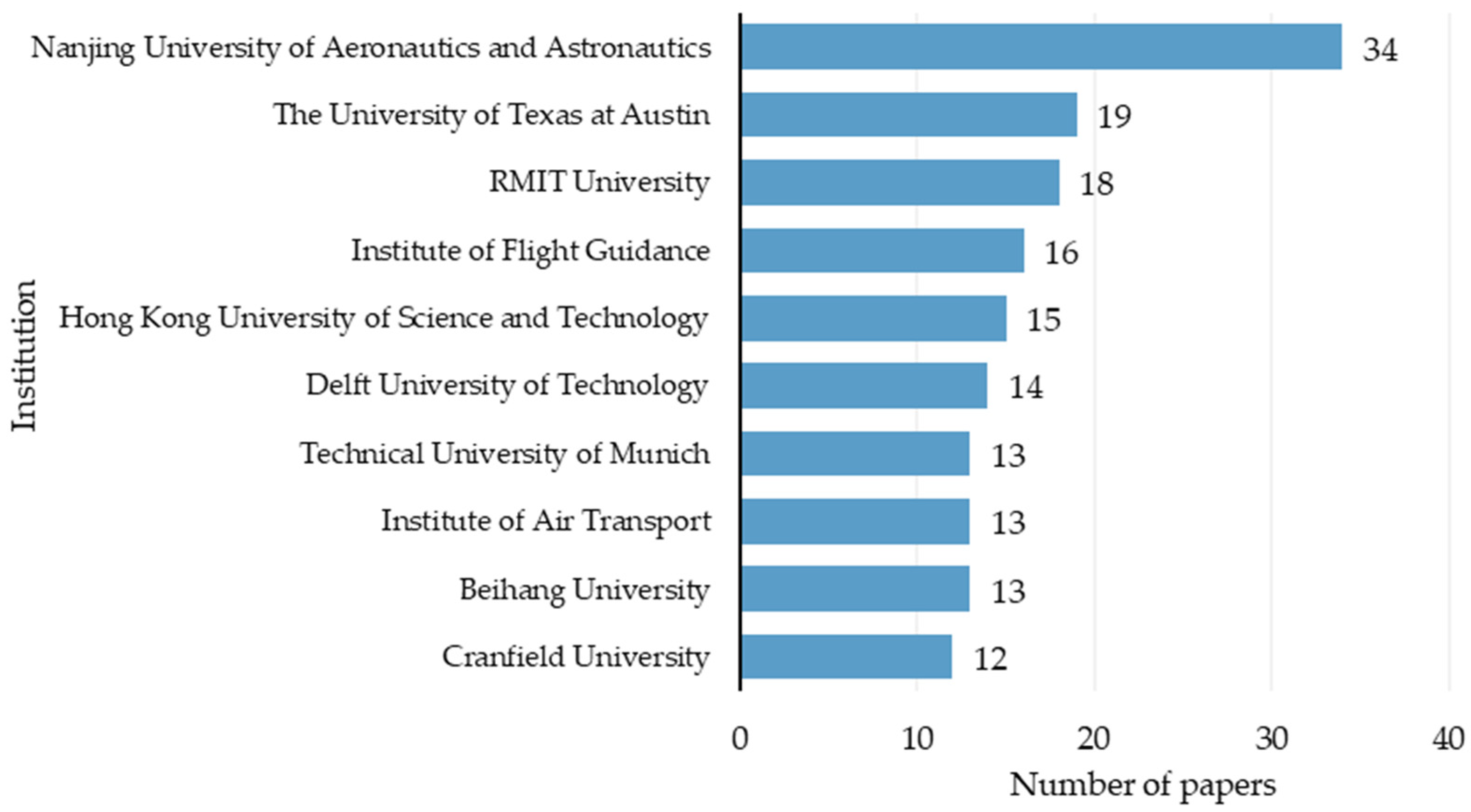
Figure 4 depicts the most relevant institutions dealing with UAM integration into the built environment, in terms of the number of papers released. With 34 articles, the Nanjing University of Aeronautics and Astronautics (China) ranks first, followed by the University of Texas at Austin (USA) with 19 manuscripts and the RMIT University (Australia) with 18 manuscripts. Then, the Institute of Flight Guidance and the Hong Kong University of Science and Technology rank fourth and fifth with 16 and 15 papers, respectively. As for the temporal evolution of scientific production, it is worth noting that some institutions exhibit a steady rise over time (such as the University of Texas at Austin), while others show rapid recent growth (such as the Nanjing University of Aeronautics and Astronautics). Overall, the majority of publications from the analysed institution have been published in recent years, primarily in 2023 and 2024. It is worth noting that all the most relevant institutions are universities, except for the Institute of Flight Guidance and the Institute of Air Transport, which are both part of the German Aerospace Center.
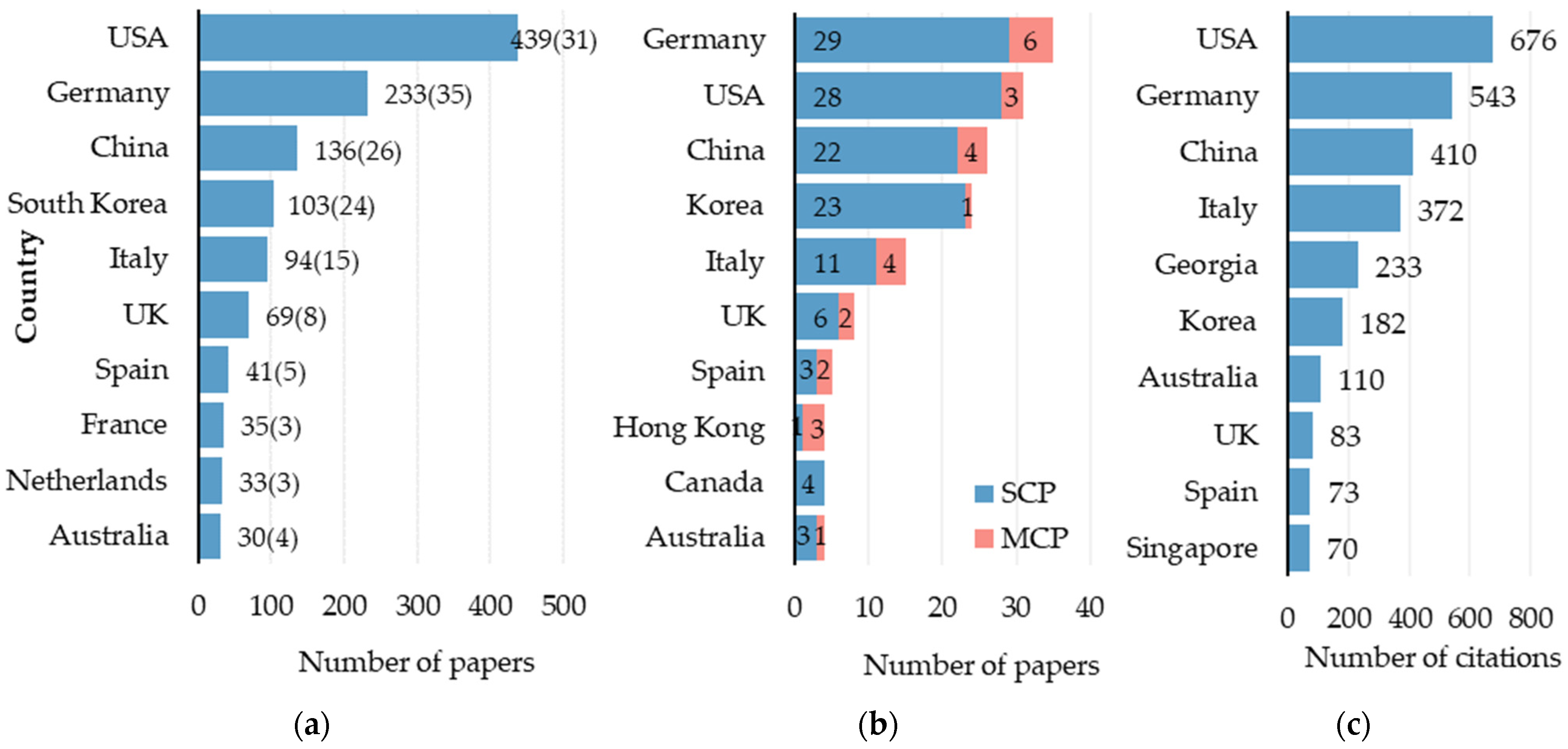
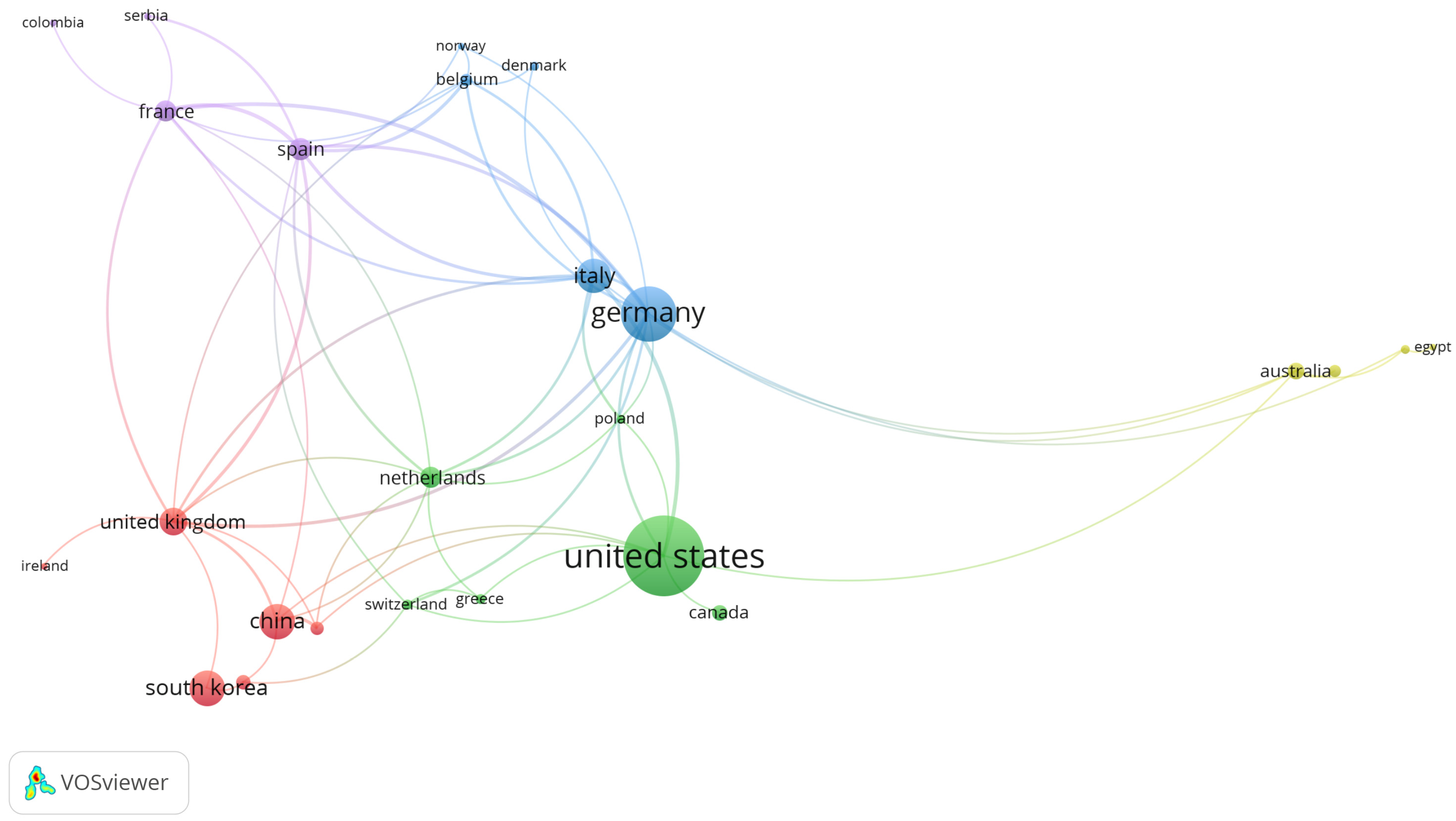
The 351 reviewed manuscripts are authored by 1071 scholars, coming from 36 different countries. More insights into the publication countries are provided in Figure 5, where they are identified based on the affiliation of all the authors. At first glance, research activities appear spatially uneven across the territory, appearing to be distributed across a limited number of countries. Specifically, Figure 5a lists the ten most prolific nations by number of papers published, with the United States leading (439 manuscripts), closely followed by Germany (233 manuscripts). Then, China and South Korea rank third and fourth, with 136 and 103 documents, respectively, followed by Italy with 94 documents. It is important to highlight that scientific production by country is based on the affiliation of all authors, with each country’s production calculated as the sum of publications from its affiliated authors. This means that the same publication can be attributed to multiple countries if the authors belong to different countries or if an author has multiple affiliations. Therefore, the number of publications shown in the figure does not reflect the actual number of unique publications but derives from this calculation approach. To provide a more reliable estimate of the number of articles per country, the count based on the affiliation of the corresponding author is also indicated in parentheses and further detailed in Figure 5b. The country analysis based on the corresponding author’s affiliation slightly alters the previous ranking, with Germany surpassing the USA in terms of the number of papers. In contrast, China, Korea, and Italy maintain their positions, confirming their third, fourth, and fifth ranks, respectively. Moreover, Figure 5c identifies the ten most impactful nations from a citation perspective. Once again, the USA and Germany emerge as the most influential countries, with the USA surpassing Germany in total citations. Notably, China remains in third place, while Italy rises to fourth place.
Overall, manuscripts appear to be mostly co-authored, with an average of four authors per document, while only 19 papers are single authored (Table 3). However, as shown in Figure 5b, these collaborations are mainly from the same country, while multiple-country publications remain limited.
Delving deeper into the collaborations between countries, Figure 6 presents a map of co-authorships by country, created using the VOSviewer software. By setting 1 as the minimum number of documents per country, the software returned 28 publication countries, whose connections are visually represented in the figure, resulting in seven clusters. The largest network includes Brazil, China, Greece, Hong Kong, the Netherlands, Singapore, South Korea, and Switzerland. In contrast, although Germany has the highest link strength, it belongs to a small cluster, highlighting collaborations with only a limited number of countries (Belgium and Norway). Surprisingly, Spain and Italy also exhibit strong collaborations, surpassing those of the USA.

3.4. Thematic Analysis

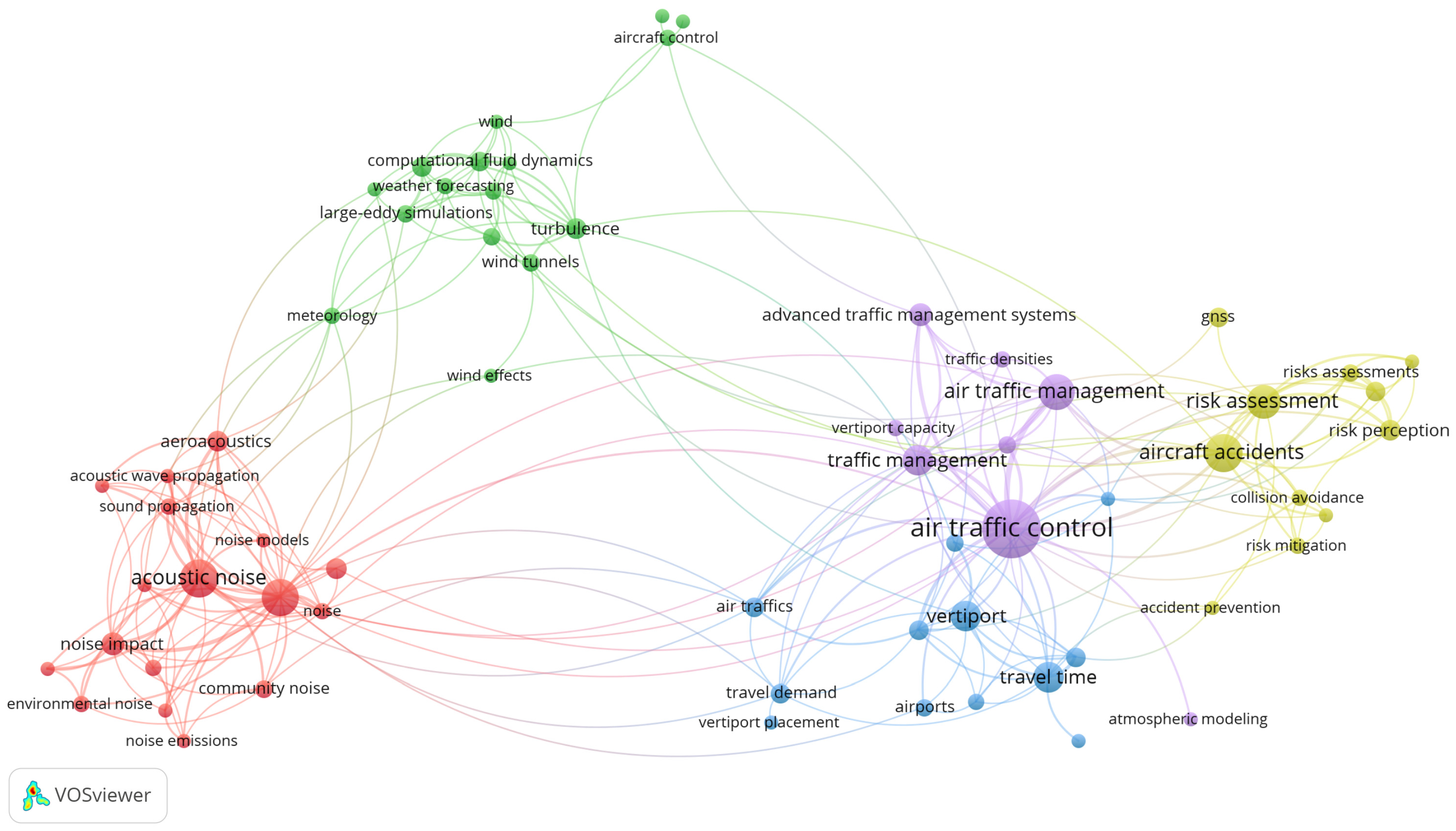
With the aim of exploring the main research themes, a co-occurrence keyword analysis was conducted using VOSviewer, enabling the network visualization (Figure 7). Indeed, the number of co-occurrences of two keywords represents the number of publications in which both keywords occur together in the title, abstract, or keyword list [43], thus providing insight into the semantic proximity of topics. As shown in the figure, keywords are indicated by their labels and a circle, whose size depends on their frequency of occurrence. The larger the font size of the label (and the circle), the more frequently the keyword appears, thus suggesting its relevance in the research field. Moreover, the thickness of the link between two keywords indicates the strength of their co-occurrence. Based on the co-occurrence, keywords are grouped into clusters (depicted with the same colour), which offer valuable information about the main research topics and how they are interconnected. For instance, clusters that are closer to each other are more strongly connected than clusters that are isolated in the map.
The analysis conducted using VOSviewer revealed that research addressing UAM from the built environment perspective can be grouped in five main clusters. Based on the identified keywords, five main research topics can be identified:
  • Air traffic management (purple cluster)
  • Acoustic noise assessment (red cluster)
  • Wind effects assessment (green cluster)
  • Risk assessment (yellow cluster)
  • Vertiports location (blue cluster)
Even though the review search was focused on the integration between UAM and the built environment, two clusters—air traffic management and risk assessment—are mainly related to UAV flight operations. Accordingly, they belong more to the aerospace engineering and aviation safety research field than to the urban environment one, although they are undoubtedly influenced by the analysed urban area. Additionally, two clusters—acoustic noise assessment and wind effects assessment—appear related to the environmental conditions, which are affected by the urban environment. Finally, the “vertiports location” cluster is the most directly related to the urban environment, since it involves spatial planning to integrate UAV ground infrastructures into cities.
Looking at their position on the map, it is worth noting that three clusters appear strongly interconnected, suggesting a more interdisciplinary research approach. In contrast, two clusters are more isolated, suggesting they represent distinct and specific research areas. On the one hand, the “air traffic management” cluster is closely connected to the “risk assessment” cluster, indicating a strong relationship between traffic control and safety operations. For instance, this relationship may derive from the relevance of collision prevention in air traffic operations. Moreover, the “air traffic management” cluster is also strongly linked to the “vertiports location” cluster, as the placement of ground infrastructures is affected by air traffic assessments. On the other hand, the “acoustic noise assessment” cluster appears to be more detached from the other ones, suggesting that it is treated as an independent research topic. However, limited connections with the “vertiports location” cluster and “wind assessment” cluster can be found. The former connection could be due to the fact that noise impact represents a crucial factor in the vertiport placement, as it could affect people’s acceptance of UAM services. The latter connection could derive from the influence of wind on noise perception. More in detail, the “wind assessment” cluster itself appears isolated in the map, suggesting that it is a more specialized research topic. However, its connection with the “air traffic control” topic could indicate the relevance of this environmental factor in defining flight operations.
Further considerations can be drawn by analysing the number of manuscripts per research theme, although some articles address multiple topics simultaneously. Overall, safety and security assessments emerge as the most extensively investigated subject, accounting for the highest number of articles, closely followed by studies on ground infrastructures, with a specific focus on vertiports. Air traffic management represents the third most investigated area, while environmental constraints—such as wind and noise—are addressed in a comparable number of articles. The following subsections provide an overview of each research domain, not intending to conduct a systematic literature review, but rather to outline the current research state of research for each topic, while attempting to establish its correlation with the built environment.

3.4.1. Air Traffic Control

A key research topic to support efficient and safe development of UAM services concerns air traffic management [27], in terms of path design and path conflict detection and resolution (CD&R), and aerospace planning. The introduction of these services could impact existing traffic management [49].
Although the topic is typically a field of aeronautical research, it is unavoidably shaped by the characteristics of the built environment in which the UAM system is to be implemented, introducing additional complexities to the airspace design, both in terms of urban morphology and existing urban infrastructure. Indeed, urban form directly influences flight path design, since safety requirements require aircraft to avoid collisions with buildings and existing ground infrastructure, defining a no-fly zone where air traffic is forbidden. However, urban constraints extend beyond the physical structures, involving factors such as urban wind, noise pollution, or privacy, each one defining a clearance boundary to be summed to create the no-fly zone.
As for conflict management, scholars revealed that among the information needed to ensure safe and efficient traffic management, there is not only information about the status of the aircraft and the trajectories expected by others, but also information about road topography (especially direction and geometry of the road network) [50,51]. Typically, to ensure safety and integration with ground traffic, drone routes tend to follow the existing road networks, as this allows them to avoid urban obstacles such as buildings, to which they must adapt their trajectory. Indeed, in the presence of urban obstacles, drones have two options: fly around the obstacle or over the obstacle. However, if all drones use the same algorithms, this could lead to potential traffic congestion and risk of collision, which must be avoided by appropriate lateral separation of flight corridors [52]. Therefore, in the definition of UAV flight algorithms, knowledge of existing buildings (in terms of height, area, number of buildings, and distances to a certain altitude) is crucial, although there are currently no databases containing this information [51]. The multitude of factors to be considered in flight route planning is confirmed by several studies, calling for innovative approaches for its management, such as the creation of multi-objective frameworks adopting an optimization approach [53,54], going so far as to propose simulation platforms to test different scenarios [55]. In addition, the capacity of the airspace itself is closely affected by terrestrial infrastructure constraints [56].
Although the urban environment is mainly intended as a constraint within mathematical models of air traffic management, some studies take innovative approaches based on the creation of digital models. Such is the case of Bubalo, who created a digital twin of aerospace, focusing on infrastructure elements, including route structures, existing airports, and future vertiports [57]. Another example is Zhang et al., who created a grid model of the city’s airspace, mapping obstacles such as buildings and infrastructure, and then adopted obstacle-based Voronoi diagrams and A* algorithms in order to obtain a network of low-lying public routes for UAVs [58], applying it to the Shanghai case study. Another approach is to create risk maps with different levels, as in the case of the SMARTGO Project [59]. Another approach based on spatial analysis is provided by Kim and Yoon, who created a mapping aimed at identifying areas most suitable for the development of UAM services, based on demographic and spatial characteristics [60]. These methodologies highlight the growing necessity of integrating urban planning principles into airspace management, emphasizing that air traffic management should not only respond to aeronautical concerns but also adapt to the constraints of the built environment.

3.4.2. Noise Pollution Due to Aircraft

One of the main concerns associated with the introduction of UAM services within urban environments is noise pollution generated by aircraft, which thus constitutes a critical research field. Indeed, it is worth noting that a low level of public acceptance of the aircraft noise can represent a significant barrier to the implementation of UAM services, particularly in densely populated areas [61]. Despite this, currently, noise regulations and operational guidelines aimed at minimizing the impact of UAM flights on surrounding communities are still in the early stages of development, thus requiring further efforts by the scientific community [25]. In fact, despite this being well-recognized as a crucial issue for UAM integration into cities, the body of literature on this topic is still limited compared to both other UAM-related studies and research on acoustic impacts of other vehicle categories. Indeed, although it is undoubtedly growing, noise-related research accounts for only one-seventh of the total number of retrieved manuscripts. Overall, the issue of aircraft noise involves four main components: the generation of noise by the aircraft, the paths it follows during flights, the effects of atmospheric propagation, and the noise perception of the receivers (people).
The characterization of UAM aircraft noise still remains an open research question in the literature, generally addressed through laboratory experiments and field measurements, which mainly evaluate individual flight events. However, realistic flight scenarios require more comprehensive explorations, since the noise derived from repeated overflights should be assessed [24]. More in detail, the study of aircraft-generated noise is approached by adopting different methodologies, which include experimental studies based on actual UAV flight measurements [62,63], but also aeroacoustic simulations that predict noise propagation under realistic operating conditions [64]. For instance, the prediction of aircraft noise appears particularly relevant in proximity to vertiports, where the ground effect could amplify the sound pressure level [65]. Consequently, a significant body of the literature focuses on noise assessment in vertiport environments [66,67], even when vertiports are located on the building roofs [68]. Indeed, in dense urban environments, sound waves undergo multiple reflections due to the interaction with building walls, leading to complex acoustic propagation patterns. In addition to the geometric influences, other factors such as atmospheric effects (particularly wind) and the Doppler effect should be considered for an accurate assessment of sound propagation. Consequently, studies on the simulation of sound propagation in urban settings appear to be the most widespread, adopting different methodologies to evaluate the complex sound reflections due to the presence of buildings. Among them, ray tracing seems to be the most commonly adopted [69,70], including its more advanced variants such as Gaussian beam tracing, which incorporates more detailed acoustic physics by accounting for propagation, reflection, absorption, and refraction phenomena [71].
Despite the growing interest in this topic, most research is still focused on aeroacoustics issues, while research on noise mitigation strategies for UAM services still appears underexplored. Overall, noise mitigation can be achieved through three main approaches: reducing the number of operations, increasing the cruise altitudes, and implementing ambient noise masking by concentrating flights over less noise-sensitive areas [72]. Accordingly, some research specifically investigates the definition of UAV flight paths with the goal of mitigating noise [73], also incorporating optimization-based approaches [74]. A novel approach in this framework relies on the concept of “virtual acoustic terrain”, which enables the identification of 3D no-fly zones also based on noise constraints, to facilitate the selection of noise-aware flight paths, while also optimizing the operational efficiency [75].
Noise mitigation in urban environments is a relevant issue to be addressed, as the annoyance rate against drones appears to be high compared to other types of aircraft [76]. However, research on drone noise perception related to UAM still appears very limited in the literature, highlighting the urgent need for dedicated studies [77].

3.4.3. Wind

The assessment of environmental conditions represents a crucial element in ensuring safe flight operations for UAM services, which are found to suffer from further challenges compared to conventional aviation [78]. Indeed, scholars have shown that adverse weather conditions can be a significant barrier to UAM operations, even due to the perception of potential users [79]. Consequently, to ensure safe UAS operations, proper communication systems are required, to be advised of weather information [80] or weather risk [81], which represent a potential gap in the drone economy.
The weather parameters potentially affecting flight operations are manifold, including fog, snow, rain, storm, and wind, which can represent a significant challenge in the effective implementation of UAM [22]. However, the literature review highlights that research efforts seem to focus on evaluations concerning the wind effect within the urban environment, rather than on the other factors. Wind paths can significantly compromise flight operations (take-off, landing, hovering), and in turn can be significantly affected by the urban morphology, since interaction with ground roughness and existing buildings could modify both wind speed and wind direction [82]. Indeed, UAM operations occur within the so-called Urban Boundary Layer (UBL), where atmospheric wind can experience significant variations, along with turbulence phenomena due to obstacles (mechanical turbulence), temperature changes on the ground (thermal turbulence), and collisions between air masses of different temperatures (frontal turbulence). Interestingly, although the literature on wind urban fluid dynamics is well established, it is oriented to other purposes (mainly pedestrian comfort assessment or urban air pollution), often unsuitable for the UAM. Accordingly, specific UAM-related studies are required; the existing ones were reviewed by Nithya et al. in 2024 [22]. Overall, different approaches to explore urban wind paths are available, starting with more precise but computationally expensive approaches, such as CFD-based analyses [23], among which approaches based on large eddy simulations (LES) [83,84], Reynolds-Averaged Navier–Stokes (RANS) equations and direct numerical simulation (DNS) turbulence models seem to be the most popular ones. However, to simplify the computational burden, hybrid methods such as reduced-order models (ROMs) are often used [85]. In addition, it is worth noting that simulation results are sometimes improved through observed data [86] or by coupling CFD models with atmospheric models [87].
Overall, an attractive research topic seems to be related to the assessment of wind flows around high-rise buildings and their resulting implications for safe flights, explored through experimental analyses (such as wind tunnels [88], simulations [89], or real data collection [90]. These studies reveal that urban density, layout and height of buildings significantly affect wind flows, thus requiring accurate predictions even for the vertiports placement [91].
Besides the specific wind-related studies purely focused on fluid dynamics, two further research issues related to wind are found to be addressed. On the one hand, some studies focus on flight path planning for UAV under wind dynamics [92,93]. On the other hand, another research topic explores aspects of controlling and guiding unmanned aircraft under wind disturbance [94,95].

3.4.4. Risk Assessment

Among all the retrieved articles, a very prominent research topic appears to be the assessment of UAM flight operations risks, confirming how research on UAM is still strongly linked to operational requirements compared to the issue of its integration within urban spaces. Indeed, most of the studies within this cluster focus on the operational aspects required to ensure safe flight operations, addressing issues related to different topics, including aircraft localization and tracking, communication and connectivity of UAM systems, conflict resolution and risk-aware path planning. All these aspects mainly refer to operational constraints typically related to air navigation. However, air navigation in urban environments introduces new complexities to be addressed: the presence of buildings and ground infrastructure, high population density and traffic congestion require careful consideration when defining aircraft operational constraints, resulting in more stringent performance requirements.
For instance, the main means of positioning for outdoor navigation are Global Navigation Satellite Systems (GNSSs), whose functionality can be significantly compromised in dense urban environments. Indeed, signals can be compromised by the presence of obstacles such as tall buildings (which block or reflect satellite signals), interference or electromagnetic disturbances. This warrants specific investigations, which appear to be a promising research topic [96,97]. In addition to studies on drone navigation, a considerable body of literature focuses on risk-aware path planning and collision management. In detail, in urban environments, the presence of vertical and horizontal obstacles can significantly affect flight paths, not only due to the presence of buildings and infrastructure, but also cables and power lines, mainly for small-UAS [98]. Obstacle management is explored both a priori, in some studies that adopted probabilistic models to define an ideal flight height [51], and during flight itself, through detect and avoid technologies, which are required for safe UAS operations [99].
Although most of the articles on the topic cover more aviation-related aspects—albeit influenced by the urban context—some of the literature focuses on the risks that flight operations can cause over the city. In detail, the risk and operational safety assessment of flights in an urban environment focuses on two main risk topics: air risk, which is related to the risk of collision during flight, and ground risk, which is closely related to the urban areas. Although there are many studies on air risk, there is still little literature on ground risk [100]. However, UAS flight operations in urban environments unavoidably involve ground risk [101] which also involves people and infrastructures [102]. The methodologies adopted to assess UAV risks are manifold, including [103]:
  • Strategic approaches (before the flight day), based on theoretical analysis and predictive models to identify areas of risk prior to actual operations. For instance, they are often expressed through ground risk maps [46], useful for defining low-risk paths in the urban environment [104].
  • Pre-tactical approaches (up to 2 h before), including planning done just before the mission, using updated data to implement safety levels.
  • Tactical approaches (during the flight), such as real-time managed re-risk during flight [50].
Overall, risk assessment aims to provide guidance for the introduction of new regulations for the certification of aircraft [105], as well as new regulations for the safe implementation of UAM services within urban spaces [106]. The introduction of new regulations is complex and slow, since policies are typically shaped by industrial needs and user experience [107]. In addition, it is worth noting that—unlike traditional aviation—the main safety concern for UAS operations focuses on third-party risk, which involves potential hazards to people and properties not involved in the UAM service [108]. Consequently, more investigations into third-party risk indicators are required to implement safety regulations accordingly.

3.4.5. Ground Infrastructure and Vertiports Placement

The fifth research cluster is related to the planning and design of ground infrastructure for UAM, involving manuscripts mainly focused on vertiport location. Undoubtedly, this topic is strongly connected to both urban morphology, as it affects siting constraints, and to urban planning, as vertiports should be easily reachable to users [109] and well-connected to other mobility options [32]. Overall, the problem of vertiports’ location is attracting increasing attention from scholars, as their effective positioning involves several factors that must be considered to ensure optimal placement, which can impact the overall efficiency of the UAM service [29]. Indeed, beyond the aircraft operational requirements, both physical constraints and environmental constraints must be addressed. On the one hand, physical constraints are typically associated with land use, considering not only existing obstacles, but also legislative constraints (for instance, zoning regulations). On the other hand, environmental constraints are mainly related to noise pollution and wind assessment. In addition, the potential integration with ground traffic, from a multi-modal transportation perspective, should be considered [110].
Given the multitude of parameters involved in optimal planning, the vertiport location identification problem is addressed in the literature with multiple approaches. Such approaches include clustering techniques, which are mainly based on k-means algorithms [111,112], heuristic approaches [113], integer programming and a solution algorithm [48], mathematical models [114], or combined techniques including AHP clustering for preliminary vertiport placement, and Genetic Algorithms for vertiport location optimization [115]. It is worth noting that a study based on AHP highlights all factors affecting the location of vertiports, considering environmental factors, traffic conditions, and transportation demand [116]. Although the literature mainly focuses on the creation of new areas to locate vertiports, some studies explore the possibility of using existing facilities to locate vertiports, potentially reducing costs and accelerating deployment timelines [117]. However, although there are potentially many facilities available, spatial constraints significantly limit their usage [118]. In dense urban environments, where vacant spaces are scarce, the integration of vertiports into existing structures—like parking lots or building roofs—could be promising, although often challenging due to inadequate architectural or structural characteristics [119]. In this context, offshore floating vertiports also emerge as promising solutions in coastal cities, if high urban density limits the availability of space to locate vertiports [120].
Once the problem of vertiport location has been solved, the proper design of its operational capacity must be addressed. This is the second main topic of vertiport research, still involving a limited number of articles. Generally speaking, the operational capacity of a vertiport is defined as the number of aircraft that can land/take off in a certain time interval, a number influenced by the clearance time of TLOFs and the arrangement of TLOFs and gates [29]. Numerous approaches are found in the literature. Currently, operational dynamics within vertiports are still poorly explored, except in a few studies [121], yet fundamental to vertiport management [122].

4. Discussion

The publication trend revealed the novelty of the analysed research field, with most articles published within the last five years. However, the citations trend also demonstrated its strong impact, as evidenced by the exponential increase in citations from the earliest publications. Nevertheless, the overall body of literature on UAM integration within the built environment remains relatively small compared to the broader UAM-related literature (which is itself still limited), highlighting the need for further research to achieve an effective adoption of the service. Currently, most publications on the topic appear in conference proceedings, mainly presented at events organized by societies such as AIAA and IEEE. In contrast, journal articles are significantly fewer, suggesting that this remains an exploratory field, with a lack of established rigorous methodologies. Notably, Germany and the United States emerge as leading countries in the sector, excelling in both research production and scientific impact. This can be attributed to various factors: on the one hand, it highlights the robust industrial strength of these nations in the aerospace field; on the other hand, it suggests significant public and private funding that supports research in this domain. Additionally, international collaborations in the field appear to be limited, with a preference for national partnerships that tend to keep research more localized within specific countries. This carries significant implications: first, it could lead to a geographical bias, as models and outcomes established in specific contexts might not be easily applicable to others, particularly when urban environments exhibit different characteristics. Moreover, this dominance enables these nations to have a stronger impact on shaping international standards and regulations. Accordingly, strengthening international collaborations appears to be essential to ensure a more inclusive perspective in the development of UAM frameworks.
The keyword co-occurrence analysis identified five main research themes: air traffic management, noise assessments, wind path assessments, vertiport location evaluations, and risk assessment. While these topics have been discussed individually, it is important to note that they are inevitably interconnected, further emphasizing the need for interdisciplinary approaches. Indeed, the keyword co-occurrence map highlights the interrelationships between the different research areas: noise pollution and wind effects appear to be more separate compared to vertiport location, air traffic management, and risk assessment, which show a greater degree of overlap. For instance, there is no doubt that air traffic control, through the selection of flight corridors, routes, and altitudes, is fundamentally linked to risk management and influences vertiport design, but it also must account for wind effects and noise exposure in urban environments. Not surprisingly, this cluster has the majority of connections compared to the others. This multitude of factors underscores the need for a multidisciplinary approach capable of considering multiple dimensions, although examples of such approaches are still scarce in the current literature. Similarly, vertiport design interacts with both risk management and noise, since factors like location, layout, and take-off and landing procedures significantly affect operational risks and potential noise pollution. In contrast, the analysis of wind effects appears relatively isolated, although it partially overlaps with air traffic management and noise propagation considerations. These interconnections highlight the importance of developing appropriate tools to support a multidisciplinary approach, although the diversity of issues and expertise required represents a considerable challenge.
Each research theme directly affects the operational requirements or constraints of UAVs used in UAM, while also being strongly shaped by the urban environment in which the service is to be implemented. Indeed, a successful implementation of UAV-based UAM into cities cannot overlook the complexities of the urban environment, which impact each of these aspects to different extents. For instance, the introduction of UAM requires a paradigm shift in air traffic management, incorporating the complexities of the urban environment and considering factors such as urban morphology, existing infrastructure, wind patterns, and noise pollution. The latter two topics—wind and noise—are often treated as distinct research areas, typically addressed within the fields of urban fluid dynamics and noise propagation. In both cases, urban morphology significantly influences their effects, either amplifying or attenuating them, leading to a variety of methodological approaches. While noise impact is critical for public acceptance, wind patterns play a key role in ensuring flight safety, and both factors ultimately affect UAV path planning. Path planning is also strongly influenced by risk management, to which urban environments introduce additional complexities, such as potential signal interference or third-party risks. Finally, ground infrastructure and vertiport location are undoubtedly the topics most closely related to urban environments, which impose physical constraints on vertiport placement, in addition to other factors such as noise and privacy concerns. However, all the topics remain open challenges, as their findings are often highly specific to the analysed urban environment, making generalization difficult. Indeed, as also emerged from the source analysis, this research area remains underexplored from the perspective of the built environment. There is a lack of standardized and widely shared metrics to assess safety, noise pollution, and risk in urban contexts, and the analysis of sources highlights the limited integration of these aspects into spatial planning practices. This underscores the need for more reliable methodologies that can, on the one hand, account for the multiple factors influencing the effective implementation of UAM, while at the same time bridging the gap between the technical requirements and urban planning practices.

5. Conclusions

Urban Air Mobility (UAM) is an increasingly attractive topic in the scientific literature as it holds the potential to revolutionize urban transportation. The present study focuses on the implementation of Urban Air Mobility (UAM) services within cities, aiming to map the current landscape of scientific research from the perspective of the urban environment. To this end, a bibliometric analysis was conducted by reviewing the literature from the past 15 years (2010–2024), specifically focusing on studies that intersect UAM with urban-related topics. Among the analyses performed, the keyword co-occurrence analysis led to the identification of the main research themes, which became the focus of a scoping review aimed at identifying the current key research directions and future perspectives. Key findings pointed out the necessity of integrating urban characteristics and planning principles into the operational framework of UAM, since the urban environment is not just a constraint in the design of UAM operations, but rather a fundamental factor in shaping all strategic and operational aspects, from UAV flight path planning to environmental considerations, as well as safety and security. Indeed, to varying extents, key research themes identified by the bibliometric analysis (air traffic management, risk assessment, environmental factors such as wind and noise, and the organization of ground infrastructure) are influenced by both urban morphology and spatial features, thus requiring context-specific analyses that reflect the complexity of each city. However, this requires a thorough understanding of the urban environments in which UAM is to be implemented. Moreover, the unique features of each city often hinder the generalization of findings, thus suggesting a novel research direction that incorporates urban factors into the definition of operational requirements. This shift calls for a more interdisciplinary approach—beyond the boundaries of the aerospace community—encouraging collaboration with urban planners, architects, and environmental experts. Indeed, understanding how cities shape and are shaped by UAV operations will be critical to ensuring the successful integration of these services into our cities. Since the UAM is still in its early stages, several approaches can still be explored to support its adoption in a way that can be accepted by local communities. For instance, a significant gap in the literature is found to be the lack of standardized and widely shared metrics to evaluate safety, security, noise pollution, and urban risk, which limits the comparability of studies’ findings. Moreover, the bibliometric analysis revealed a significative disciplinary bias, with aerospace and engineering perspective prevailing over the urban and planning points of view. Furthermore, the limited adoption of multidisciplinary tools represents a methodological gap that hinders the investigation of UAM in real contexts. Consequently, the integration of UAM concepts into urban planning remains limited, suggesting the need for stronger collaboration between aerospace engineers, urban planners, and policymakers.
It is important to note that some limitations can be highlighted in this work: although guided by specific research questions, the selected research strategy may have influenced the results of the analysis. Furthermore, it should be noted that the literature on the topic is still limited and fragmented, while evolving rapidly, which may affect the generalizability of the findings.
Overall, some future research directions from the city perspective could include:
  • Encouraging the use of risk mapping to compare UAV operation scenarios, which can be useful to identify high-exposure areas or potential hazards based on different perspectives. The visualization of risk could help planners to evaluate and compare different UAM implementation strategies, considering the risk mitigation for both citizens and urban infrastructure.
  • Creating comprehensive urban spatial databases containing detailed information about urban features (morphology, infrastructure, and risk zones), which could be a reliable basis to perform accurate simulations, improving the planners’ awareness of the existing urban environment.
  • Developing urban digital twins to support real-time simulations and planning UAV operations in different scenarios. Indeed, urban digital twins can provide a high-fidelity virtual representation of the city, allowing UAV trajectories to be tested under different boundary conditions, while also predicting the environmental impacts, like wind effect and noise pollution.
  • Developing multi-objective optimization frameworks for UAV path planning, incorporating real-time urban and environmental constraints. Such frameworks should include multiple objectives, balancing the minimisation of noise pollution, safety and security, while also considering real-time traffic, weather, and urban conditions.

Supplementary Materials

The following supporting information can be downloaded at https://www.mdpi.com/article/10.3390/drones9100692/s1, search string adopted to conduct the literature review.

Author Contributions

Methodology, L.M.C., F.C., F.F., E.R.M., M.O. and M.M.; formal analysis, L.M.C., F.C., F.F., E.R.M., M.O. and M.M.; investigation, L.M.C.; data curation, L.M.C.; writing—original draft preparation, L.M.C.; writing—review and editing, F.C., F.F., E.R.M., M.O. and M.M.; visualization, L.M.C.; supervision, F.F., M.O. and M.M.; funding acquisition, F.F., M.O. and M.M. All authors have read and agreed to the published version of the manuscript.

Funding

This research was supported by the project SCIAME—Smart City Integrated Air Mobility Evolution (code F/310305/01-05/X56, CUP. B99J23000370005), funded by the “Partnerships for Innovation” program of the Italian Ministry of Enterprises and Made in Italy.

Data Availability Statement

The original contributions presented in the study are included in the article and Supplementary Materials, further inquiries can be directed to the corresponding author.

Conflicts of Interest

The authors declare no conflicts of interest.

References

  1. EASA. What Is UAM. Available online: https://www.easa.europa.eu/en/what-is-uam (accessed on 8 January 2025).
  2. Garrow, L.A.; German, B.J.; Leonard, C.E. Urban Air Mobility: A Comprehensive Review and Comparative Analysis with Autonomous and Electric Ground Transportation for Informing Future Research. Transp. Res. Part. C Emerg. Technol. 2021, 132, 103377. [Google Scholar] [CrossRef]
  3. Rezende, R.N.; Barros, E.; Perez, V. General Aviation 2025—A Study for Electric Propulsion. In Proceedings of the 2018 Joint Propulsion Conference, Cincinnati, OH, USA, 9–11 July 2018; American Institute of Aeronautics and Astronautics: Reston, VA, USA, 2018. [Google Scholar]
  4. Littell, J.D.; Gardner, N.W.; Ellafrits, S.A. Dynamic Testing of EVTOL Energy Storage Systems: Literature Review and Path Forward; National Aeronautics and Space Administration Langley Research Center: Hampton, VA, USA, 2023. [Google Scholar]
  5. Moore, M. NASA Puffin Electric Tailsitter VTOL Concept. In Proceedings of the 10th AIAA Aviation Technology, Integration, and Operations (ATIO) Conference, Fort Worth, TX, USA, 13–15 September 2010; p. 9345. [Google Scholar]
  6. Xiang, S.; Xie, A.; Ye, M.; Yan, X.; Han, X.; Niu, H.; Li, Q.; Huang, H. Autonomous EVTOL: A Summary of Researches and Challenges. Green Energy Intell. Transp. 2024, 3, 100140. [Google Scholar] [CrossRef]
  7. Hu, L.; Yan, X.; Yuan, Y. Development and Challenges of Autonomous Electric Vertical Take-off and Landing Aircraft. Heliyon 2025, 11, e41055. [Google Scholar] [CrossRef]
  8. Vidović, A.; Štimac, I.; Mihetec, T.; Patrlj, S. Application of Drones in Urban Areas. Transp. Res. Procedia 2024, 81, 84–97. [Google Scholar] [CrossRef]
  9. KPMG Aviation 2030. Passenger Use Cases in the Advanced Air Mobility Revolution. 2022. Available online: https://assets.kpmg.com/content/dam/kpmg/ie/pdf/2022/07/ie-advanced-air-mobility-revolution.pdf (accessed on 8 January 2025).
  10. Rothfeld, R.; Fu, M.; Balać, M.; Antoniou, C. Potential Urban Air Mobility Travel Time Savings: An Exploratory Analysis of Munich, Paris, and San Francisco. Sustainability 2021, 13, 2217. [Google Scholar] [CrossRef]
  11. Yedavalli, P.S.; Onat, E.; Peng, X.; Sengupta, R.; Waddell, P.; Bulusu, V.; Xue, M. Assessing the Value of Urban Air Mobility through Metropolitan-Scale Microsimulation: A Case Study of the San Francisco Bay Area. In Proceedings of the AIAA AVIATION 2021 FORUM, Virtual, 2–6 August 2021; American Institute of Aeronautics and Astronautics: Reston, VA, USA, 2021. [Google Scholar]
  12. Tojal, M.; Paletti, L. Is Urban Air Mobility Environmentally Feasible? Defining the Guidelines for a Sustainable Implementation of Its Ecosystem. Transp. Res. Procedia 2023, 72, 1747–1754. [Google Scholar] [CrossRef]
  13. Zhao, P.; Post, J.; Wu, Z.; Du, W.; Zhang, Y. Environmental Impact Analysis of On-Demand Urban Air Mobility: A Case Study of the Tampa Bay Area. Transp. Res. D Transp. Environ. 2022, 110, 103438. [Google Scholar] [CrossRef]
  14. EASA Drones & EVTOL Designs. Available online: https://www.easa.europa.eu/en/domains/drones-air-mobility/drones-evtol-designs (accessed on 8 January 2025).
  15. Durán-Delfín, J.E.; García-Beltrán, C.D.; Guerrero-Sánchez, M.E.; Valencia-Palomo, G.; Hernández-González, O. Modeling and Passivity-Based Control for a Convertible Fixed-Wing VTOL. Appl. Math. Comput. 2024, 461, 128298. [Google Scholar] [CrossRef]
  16. Estevez, J.; Garate, G.; Lopez-Guede, J.M.; Larrea, M. Review of Aerial Transportation of Suspended-Cable Payloads with Quadrotors. Drones 2024, 8, 35. [Google Scholar] [CrossRef]
  17. Hegde, A.; Ghose, D. Multi-UAV Collaborative Transportation of Payloads With Obstacle Avoidance. IEEE Control Syst. Lett. 2022, 6, 926–931. [Google Scholar] [CrossRef]
  18. Straubinger, A.; Rothfeld, R.; Shamiyeh, M.; Büchter, K.-D.; Kaiser, J.; Plötner, K.O. An Overview of Current Research and Developments in Urban Air Mobility—Setting the Scene for UAM Introduction. J. Air Transp. Manag. 2020, 87, 101852. [Google Scholar] [CrossRef]
  19. Cohen, A.P.; Shaheen, S.A.; Farrar, E.M. Urban Air Mobility: History, Ecosystem, Market Potential, and Challenges. IEEE Trans. Intell. Transp. Syst. 2021, 22, 6074–6087. [Google Scholar] [CrossRef]
  20. Pak, H.; Asmer, L.; Kokus, P.; Schuchardt, B.I.; End, A.; Meller, F.; Schweiger, K.; Torens, C.; Barzantny, C.; Becker, D.; et al. Can Urban Air Mobility Become Reality? Opportunities and Challenges of UAM as Innovative Mode of Transport and DLR Contribution to Ongoing Research. CEAS Aeronaut. J. 2024, 16, 665–695. [Google Scholar] [CrossRef]
  21. Zewde, L.; Raptis, I.A. Conceptualizing UAM: Technologies and Methods for Safe and Efficient Urban Air Transportation. Green Energy Intell. Transp. 2025; in press. [Google Scholar] [CrossRef]
  22. Nithya, D.S.; Quaranta, G.; Muscarello, V.; Liang, M. Review of Wind Flow Modelling in Urban Environments to Support the Development of Urban Air Mobility. Drones 2024, 8, 147. [Google Scholar] [CrossRef]
  23. García-Gutiérrez, A.; Gonzalo, J.; López, D.; Delgado, A. Advances in CFD Modeling of Urban Wind Applied to Aerial Mobility. Fluids 2022, 7, 246. [Google Scholar] [CrossRef]
  24. Lotinga, M.J.B.; Ramos-Romero, C.; Green, N.; Torija, A.J. Noise from Unconventional Aircraft: A Review of Current Measurement Techniques, Psychoacoustics, Metrics and Regulation. Curr. Pollut. Rep. 2023, 9, 724–745. [Google Scholar] [CrossRef]
  25. Kapoor, R.; Kloet, N.; Gardi, A.; Mohamed, A.; Sabatini, R. Sound Propagation Modelling for Manned and Unmanned Aircraft Noise Assessment and Mitigation: A Review. Atmosphere 2021, 12, 1424. [Google Scholar] [CrossRef]
  26. Yang, C.; Wallace, R.J.; Huang, C. A Review and Bibliometric Analysis of Unmanned Aerial System (UAS) Noise Studies Between 2015 and 2024. Acoustics 2024, 6, 997–1020. [Google Scholar] [CrossRef]
  27. Schuchardt, B.I.; Geister, D.; Lüken, T.; Knabe, F.; Metz, I.C.; Peinecke, N.; Schweiger, K. Air Traffic Management as a Vital Part of Urban Air Mobility—A Review of DLR’s Research Work from 1995 to 2022. Aerospace 2023, 10, 81. [Google Scholar] [CrossRef]
  28. Mavraj, G.; Eltgen, J.; Fraske, T.; Swaid, M.; Berling, J.; Röntgen, O.; Fu, Y.; Schulz, D. A Systematic Review of Ground-Based Infrastructure for the Innovative Urban Air Mobility. Trans. Aerosp. Res. 2022, 2022, 1–17. [Google Scholar] [CrossRef]
  29. Brunelli, M.; Ditta, C.C.; Postorino, M.N. New Infrastructures for Urban Air Mobility Systems: A Systematic Review on Vertiport Location and Capacity. J. Air Transp. Manag. 2023, 112, 102460. [Google Scholar] [CrossRef]
  30. Schweiger, K.; Preis, L. Urban Air Mobility: Systematic Review of Scientific Publications and Regulations for Vertiport Design and Operations. Drones 2022, 6, 179. [Google Scholar] [CrossRef]
  31. Wild, G. Urban Aviation: The Future Aerospace Transportation System for Intercity and Intracity Mobility. Urban Sci. 2024, 8, 218. [Google Scholar] [CrossRef]
  32. Pons-Prats, J.; Živojinović, T.; Kuljanin, J. On the Understanding of the Current Status of Urban Air Mobility Development and Its Future Prospects: Commuting in a Flying Vehicle as a New Paradigm. Transp. Res. E Logist. Transp. Rev. 2022, 166, 102868. [Google Scholar] [CrossRef]
  33. Zupic, I.; Čater, T. Bibliometric Methods in Management and Organization. Organ. Res. Methods 2015, 18, 429–472. [Google Scholar] [CrossRef]
  34. Arksey, H.; O’Malley, L. Scoping Studies: Towards a Methodological Framework. Int. J. Soc. Res. Methodol. 2005, 8, 19–32. [Google Scholar] [CrossRef]
  35. Page, M.J.; Mckenzie, J.E.; Bossuyt, P.M.; Boutron, I.; Hoffmann, T.C.; Mulrow, C.D.; Shamseer, L.; Tetzlaff, J.M.; Akl, E.A.; Brennan, S.E.; et al. The PRISMA 2020 Statement: An Updated Guideline for Reporting Systematic Reviews. BMJ 2021, 372, 71. [Google Scholar] [CrossRef]
  36. van Eck, N.J.; Waltman, L. Software Survey: VOSviewer, a Computer Program for Bibliometric Mapping. Scientometrics 2010, 84, 523–538. [Google Scholar] [CrossRef] [PubMed]
  37. Biblioshiny. Available online: https://bibliometrix.org/biblioshiny/biblioshiny1.html (accessed on 14 March 2025).
  38. Aria, M.; Cuccurullo, C. Bibliometrix: An R-Tool for Comprehensive Science Mapping Analysis. J. Informetr. 2017, 11, 959–975. [Google Scholar] [CrossRef]
  39. Zhu, J.; Liu, W. A Tale of Two Databases: The Use of Web of Science and Scopus in Academic Papers. Scientometrics 2020, 123, 321–335. [Google Scholar] [CrossRef]
  40. Aghaei Chadegani, A.; Salehi, H.; Yunus, M.; Farhadi, H.; Fooladi, M.; Farhadi, M.; Ale Ebrahim, N. A Comparison between Two Main Academic Literature Collections: Web of Science and Scopus Databases. Asian Soc. Sci. 2013, 9, 18–26. [Google Scholar] [CrossRef]
  41. Mongeon, P.; Paul-Hus, A. The Journal Coverage of Web of Science and Scopus: A Comparative Analysis. Scientometrics 2015, 106, 213–228. [Google Scholar] [CrossRef]
  42. Zhao, X.; Zuo, J.; Wu, G.; Huang, C. A Bibliometric Review of Green Building Research 2000–2016. Archit. Sci. Rev. 2019, 62, 74–88. [Google Scholar] [CrossRef]
  43. van Eck, N.J.; Waltman, L. Visualizing Bibliometric Networks. In Measuring Scholarly Impact; Springer International Publishing: Cham, Switzerland, 2014; pp. 285–320. [Google Scholar]
  44. Barrado, C.; Boyero, M.; Brucculeri, L.; Ferrara, G.; Hately, A.; Hullah, P.; Martin-Marrero, D.; Pastor, E.; Rushton, A.P.; Volkert, A. U-Space Concept of Operations: A Key Enabler for Opening Airspace to Emerging Low-Altitude Operations. Aerospace 2020, 7, 24. [Google Scholar] [CrossRef]
  45. Falco, G.; Pini, M.; Marucco, G. Loose and Tight GNSS/INS Integrations: Comparison of Performance Assessed in Real Urban Scenarios. Sensors 2017, 17, 255. [Google Scholar] [CrossRef]
  46. Primatesta, S.; Rizzo, A.; la Cour-Harbo, A. Ground Risk Map for Unmanned Aircraft in Urban Environments. J. Intell. Robot. Syst. 2020, 97, 489–509. [Google Scholar] [CrossRef]
  47. Primatesta, S.; Guglieri, G.; Rizzo, A. A Risk-Aware Path Planning Strategy for UAVs in Urban Environments. J. Intell. Robot. Syst. 2019, 95, 629–643. [Google Scholar] [CrossRef]
  48. Wu, Z.; Zhang, Y. Integrated Network Design and Demand Forecast for On-Demand Urban Air Mobility. Engineering 2021, 7, 473–487. [Google Scholar] [CrossRef]
  49. Schier-Morgenthal, S.; Metz, I.C. Impact of Airtaxi Operations in the Control Zone on Air Traffic Controllers. CEAS Aeronaut. J. 2024, 16, 849–856. [Google Scholar] [CrossRef]
  50. Andrei Badea, C.; Ellerbroek, J.; Hoekstra, J. The Benefits of Using Intent Information in Tactical Conflict Resolution for U-Space/UTM Operations. IEEE Trans. Intell. Transp. Syst. 2025, 26, 1864–1875. [Google Scholar] [CrossRef]
  51. Thoma, A.; Gardi, A.; Fisher, A.; Braun, C. Obstacle Encounter Probability Dependent Local Path Planner for UAV Operation in Urban Environments. CEAS Aeronaut. J. 2024, 15, 867–879. [Google Scholar] [CrossRef]
  52. Yang, Y.; Choi, S.; Kim, H. A Study on Lateral Separation for Urban Air Mobility Using Simulation Model. In Proceedings of the 2024 AIAA DATC/IEEE 43rd Digital Avionics Systems Conference (DASC), San Diego, CA, USA, 29 September–3 October 2024; pp. 01–09. [Google Scholar]
  53. Hohmann, N.; Brulin, S.; Adamy, J.; Olhofer, M. Three-Dimensional Urban Path Planning for Aerial Vehicles Regarding Many Objectives. IEEE Open J. Intell. Transp. Syst. 2023, 4, 639–652. [Google Scholar] [CrossRef]
  54. Aldao, E.; Fontenla-Carrera, G.; González-deSantos, L.M.; González-Jorge, H. UAV Path Planning for the Delivery of Emergency Medical Supplies. In Proceedings of the 2023 International Conference on Unmanned Aircraft Systems (ICUAS), Warsaw, Poland, 6–9 June 2023; pp. 687–694. [Google Scholar]
  55. Pinto Neto, E.C.; Baum, D.M.; de Almeida, J.R.; Camargo, J.B.; Cugnasca, P.S. A Trajectory Evaluation Platform for Urban Air Mobility (UAM). IEEE Trans. Intell. Transp. Syst. 2022, 23, 9136–9145. [Google Scholar] [CrossRef]
  56. Di Mascio, P.; Celesti, M.; Sabatini, M.; Moretti, L. Fast-Time Simulations to Study the Capacity of a Traffic Network Aimed at Urban Air Mobility. Future Transp. 2024, 4, 1370–1387. [Google Scholar] [CrossRef]
  57. Bubalo, B. Capacity and Demand Forecasting in Urban Air Mobility—A Simulation of Air Transportation in Hamburg. Transp. Res. Procedia 2024, 80, 11–19. [Google Scholar] [CrossRef]
  58. Zhang, H.; Tian, T.; Feng, O.; Wu, S.; Zhong, G. Research on Public Air Route Network Planning of Urban Low-Altitude Logistics Unmanned Aerial Vehicles. Sustainability 2023, 15, 12021. [Google Scholar] [CrossRef]
  59. Fasano, G.; Causa, F.; Franzone, A.; Piccolo, C.; Cricelli, L.; Mennella, A.; Pisacane, V. Path Planning for Aerial Mobility in Urban Scenarios: The SMARTGO Project. In Proceedings of the 2022 IEEE 9th International Workshop on Metrology for AeroSpace (MetroAeroSpace), Pisa, Italy, 27–29 June 2022; pp. 124–129. [Google Scholar]
  60. Kim, N.; Yoon, Y. Regionalization for Urban Air Mobility Application with Analyses of 3D Urban Space and Geodemography in San Francisco and New York. Procedia Comput. Sci. 2021, 184, 388–395. [Google Scholar] [CrossRef]
  61. Antcliff, K.R.; Moore, M.D.; Goodrich, K.H. Silicon Valley as an Early Adopter for On-Demand Civil VTOL Operations. In Proceedings of the 16th AIAA Aviation Technology, Integration, and Operations Conference, Washington, DC, USA, 13–17 June 2016; American Institute of Aeronautics and Astronautics: Reston, VA, USA, 2016. [Google Scholar]
  62. Alexander, W.N.; Whelchel, J. Flyover Noise of Multi-Rotor SUAS. In Proceedings of the INTER-NOISE 2019 MADRID—48th International Congress and Exhibition on Noise Control Engineering, Madrid, Spain, 16–19 June 2019. [Google Scholar]
  63. Schmähl, M.; Rieger, C.; Speck, S.; Hornung, M. Semi-Empiric Noise Modeling of a Cargo EVTOL UAV by Means of System Identification from Flight Noise Measurement Data. CEAS Aeronaut. J. 2022, 13, 85–96. [Google Scholar] [CrossRef]
  64. Barbarino, M.; Petrosino, F.; Visingardi, A. A High-Fidelity Aeroacoustic Simulation of a VTOL Aircraft in an Urban Air Mobility Scenario. Aerosp. Sci. Technol. 2022, 125, 107104. [Google Scholar] [CrossRef]
  65. Araghizadeh, M.S.; Sengupta, B.; Lee, H.; Myong, R.S. Aeroacoustic Investigation of Side-by-Side Urban Air Mobility Aircraft in Full Configuration with Ground Effect. Phys. Fluids 2024, 36, 087160. [Google Scholar] [CrossRef]
  66. Yunus, F.; Casalino, D.; Avallone, F.; Ragni, D. Efficient Prediction of Urban Air Mobility Noise in a Vertiport Environment. Aerosp. Sci. Technol. 2023, 139, 108410. [Google Scholar] [CrossRef]
  67. Yunus, F.; Varriale, C.; Snellen, M. Efficient Noise Footprint Computation for Urban Air Mobility Maneuvers in Vertiport Environments. In Proceedings of the 30th AIAA/CEAS Aeroacoustics Conference (2024), Rome, Italy, 4–7 June 2024; American Institute of Aeronautics and Astronautics: Reston, VA, USA, 2024. [Google Scholar]
  68. Marques Goncalves, M.; Golubev, V.V.; Lyrintzis, A.S.; Mankbadi, R.R. High-Fidelity Simulations of Vertiport Ground Effects on EVTOL Rotor Noise. In Proceedings of the 30th AIAA/CEAS Aeroacoustics Conference (2024), Rome, Italy, 4–7 June 2024; American Institute of Aeronautics and Astronautics: Reston, VA, USA, 2024. [Google Scholar]
  69. Malbéqui, P.R. Assessment of Sound Propagation for the Urban Air Mobility. J. Acoust. Soc. Am. 2023, 153, A325. [Google Scholar] [CrossRef]
  70. Kim, Y.; Lee, S. Deep Learning Based Prediction of Urban Air Mobility Noise Propagation in Urban Environment. J. Acoust. Soc. Am. 2024, 155, 171–187. [Google Scholar] [CrossRef]
  71. Bian, H.; Tan, Q.; Zhong, S.; Zhang, X. Reprint of: Assessment of UAM and Drone Noise Impact on the Environment Based on Virtual Flights. Aerosp. Sci. Technol. 2022, 125, 107547. [Google Scholar] [CrossRef]
  72. Gao, Z.; Yu, Y.; Wei, Q.; Topcu, U.; Clarke, J.-P. Noise-Aware and Equitable Urban Air Traffic Management: An Optimization Approach. Transp. Res. Part. C Emerg. Technol. 2024, 165, 104740. [Google Scholar] [CrossRef]
  73. Tan, Q.; Li, Y.; Wu, H.; Zhou, P.; Lo, H.K.; Zhong, S.; Zhang, X. Enhancing Sustainable Urban Air Transportation: Low-Noise UAS Flight Planning Using Noise Assessment Simulator. Aerosp. Sci. Technol. 2024, 147, 109071. [Google Scholar] [CrossRef]
  74. Centracchio, F.; Burghignoli, L.; Iemma, U. Multiobjective Optimisation of Flight Paths for Noise Level Mitigation and Sound Quality Improvement. Noise Mapp. 2021, 8, 268–280. [Google Scholar] [CrossRef]
  75. Gao, Z.; Porcayo, A.; Clarke, J.-P. Developing Virtual Acoustic Terrain for Urban Air Mobility Trajectory Planning. Transp. Res. D Transp. Environ. 2023, 120, 103794. [Google Scholar] [CrossRef]
  76. Aalmoes, R.; Sieben, N. Visual and Audio Perception Study on Drone Aircraft and Similar Sounds in an Urban Air Mobility Setting. Inter-Noise Noise-Con Congr. Conf. Proc. 2021, 263, 2510–2521. [Google Scholar] [CrossRef]
  77. Aalmoes, R.; Tojal Castro, M.; Sieben, N.; Roosien, R. Drone Noise in My Backyard: The Challenges for Public Acceptability. Inter-Noise Noise-Con Congr. Conf. Proc. 2023, 265, 4987–4993. [Google Scholar] [CrossRef]
  78. Reiche, C.; Cohen, A.P.; Fernando, C. An Initial Assessment of the Potential Weather Barriers of Urban Air Mobility. IEEE Trans. Intell. Transp. Syst. 2021, 22, 6018–6027. [Google Scholar] [CrossRef]
  79. Reiche, C.; McGillen, C.; Siegel, J.; Brody, F. Are We Ready to Weather Urban Air Mobility (UAM)? In Proceedings of the 2019 Integrated Communications, Navigation and Surveillance Conference (ICNS), Herndon, VA, USA, 9–11 April 2019; pp. 1–7. [Google Scholar]
  80. Fala, N.; Wallace, J.W. Identification of Potential Gaps and Requirements in Weather Sources for General Aviation and UAS Operations. In Proceedings of the AIAA AVIATION 2021 FORUM, Virtual, 2–6 August 2021; American Institute of Aeronautics and Astronautics: Reston, VA, USA, 2021. [Google Scholar]
  81. Bajaj, A.; Philips, B.; Lyons, E.; Westbrook, D.; Zink, M. Determining and Communicating Weather Risk in The New Drone Economy. In Proceedings of the 2020 IEEE 92nd Vehicular Technology Conference (VTC2020-Fall), Victoria, BC, Canada, 18 November–16 December 2020; pp. 1–6. [Google Scholar]
  82. Otte, T.; Metzner, N.; Lipp, J.; Schwienhorst, M.S.; Solvay, A.F.; Meisen, T. User-Centered Integration of Automated Air Mobility into Urban Transportation Networks. In Proceedings of the 2018 IEEE/AIAA 37th Digital Avionics Systems Conference (DASC), London, UK, 23–27 September 2018; pp. 1–10. [Google Scholar]
  83. Yang, M.; Oh, G.; Choi, J.-I. A Multi-GPU Based LES Urban Wind Flow Solver for Real-Time Simulation; Springer: Berlin/Heidelberg, Germany, 2023; pp. 199–202. [Google Scholar]
  84. Giersch, S.; El Guernaoui, O.; Raasch, S.; Sauer, M.; Palomar, M. Atmospheric Flow Simulation Strategies to Assess Turbulent Wind Conditions for Safe Drone Operations in Urban Environments. J. Wind. Eng. Ind. Aerodyn. 2022, 229, 105136. [Google Scholar] [CrossRef]
  85. Krawczyk, Z.; Vuppala, R.K.S.S.; Paul, R.; Kara, K. Evaluating Reduced-Order Urban Wind Models for Simulating Flight Dynamics of Advanced Aerial Mobility Aircraft. Aerospace 2024, 11, 830. [Google Scholar] [CrossRef]
  86. Chrit, M. Reconstructing Urban Wind Flows for Urban Air Mobility Using Reduced-Order Data Assimilation. Theor. Appl. Mech. Lett. 2023, 13, 100451. [Google Scholar] [CrossRef]
  87. Chrit, M.; Majdi, M. Improving Wind Speed Forecasting for Urban Air Mobility Using Coupled Simulations. Adv. Meteorol. 2022, 2022, 1–14. [Google Scholar] [CrossRef]
  88. Al Labbad, M.; Wall, A.; Larose, G.L.; Khouli, F.; Barber, H. Experimental Investigations into the Effect of Urban Airflow Characteristics on Urban Air Mobility Applications. J. Wind. Eng. Ind. Aerodyn. 2022, 229, 105126. [Google Scholar] [CrossRef]
  89. Mohamed, A.; Marino, M.; Watkins, S.; Jaworski, J.; Jones, A. Gusts Encountered by Flying Vehicles in Proximity to Buildings. Drones 2022, 7, 22. [Google Scholar] [CrossRef]
  90. Barber, H.; Wall, A.; Larose, G.L.; Schajnoha, S. RPAS Operations in Urban Airflow: Efficient Modelling of Representative Wind Speed Variations along a Flight Path through a Flow Field with Changing Turbulence Characteristics. J. Wind. Eng. Ind. Aerodyn. 2024, 247, 105702. [Google Scholar] [CrossRef]
  91. Yeo, H.; Lee, S. Impact of Heterogeneous Building Arrangement on Local Turbulence Escalation. Build. Environ. 2023, 236, 110217. [Google Scholar] [CrossRef]
  92. Chan, Y.Y.; Ng, K.K.H.; Lee, C.K.M.; Hsu, L.-T.; Keung, K.L. Wind Dynamic and Energy-Efficiency Path Planning for Unmanned Aerial Vehicles in the Lower-Level Airspace and Urban Air Mobility Context. Sustain. Energy Technol. Assess. 2023, 57, 103202. [Google Scholar] [CrossRef]
  93. Pradeep, P.; Lauderdale, T.A.; Chatterji, G.B.; Sheth, K.; Lai, C.F.; Sridhar, B.; Edholm, K.-M.; Erzberger, H. Wind-Optimal Trajectories for Multirotor EVTOL Aircraft on UAM Missions. In Proceedings of the AIAA AVIATION 2020 FORUM, Virtual, 15–19 June 2020; American Institute of Aeronautics and Astronautics: Reston, VA, USA, 2020. [Google Scholar]
  94. Bilgin, Z.; Yavrucuk, I.; Bronz, M. Urban Air Mobility Guidance with Panel Method: Experimental Evaluation Under Wind Disturbances. J. Guid. Control. Dyn. 2024, 47, 1080–1096. [Google Scholar] [CrossRef]
  95. Foster, J.V.; Miller, L.J.; Busan, R.C.; Langston, S.; Hartman, D. Recent NASA Wind Tunnel Free-Flight Testing Of A Multirotor Unmanned Aircraft System. In Proceedings of the AIAA Scitech 2020 Forum, Orlando, FL, USA, 6–10 January 2020; American Institute of Aeronautics and Astronautics: Reston, VA, USA, 2020. [Google Scholar]
  96. Isik, O.K.; Petrunin, I.; Tsourdos, A. Machine Learning-Based Environment-Aware GNSS Integrity Monitoring for Urban Air Mobility. Drones 2024, 8, 690. [Google Scholar] [CrossRef]
  97. Wi, H.; Jang, I.; Hong, S.G. Simulation Design for Learning Data Collection to Estimate UAM Location in GNSS-Denied Using 3D Spatial Information. In Proceedings of the 2024 Fifteenth International Conference on Ubiquitous and Future Networks (ICUFN), Budapest, Hungary, 2–5 July 2024; pp. 541–543. [Google Scholar]
  98. Viana Junior, A.A.; Sergio Cugnasca, P. Detecting Cables and Power Lines in Small-UAS (Unmanned Aircraft Systems) Images through Deep Learning. In Proceedings of the 2021 IEEE/AIAA 40th Digital Avionics Systems Conference (DASC), San Antonio, TX, USA, 3–7 October 2021; pp. 1–7. [Google Scholar]
  99. Martinez, V.C.; Ince, B.; Selvam, P.K.; Petrunin, I.; Seo, M.; Anastassacos, E.; Royall, P.G.; Cole, A.; Tsourdos, A.; Knorr, S. Detect and Avoid Considerations for Safe SUAS Operations in Urban Environments. In Proceedings of the 2021 IEEE/AIAA 40th Digital Avionics Systems Conference (DASC), San Antonio, TX, USA, 3–7 October 2021; pp. 1–10. [Google Scholar]
  100. Choi, S.; Kim, B.; Kim, H. Third-Party Risk Assessment on the Ground for Urban Air Mobility Operations: A Case Study of Seoul Metropolitan City. Int. J. Aeronaut. Space Sci. 2024, 26, 883–895. [Google Scholar] [CrossRef]
  101. Jiao, Q.; Liu, Y.; Zheng, Z.; Sun, L.; Bai, Y.; Zhang, Z.; Sun, L.; Ren, G.; Zhou, G.; Chen, X.; et al. Ground Risk Assessment for Unmanned Aircraft Systems Based on Dynamic Model. Drones 2022, 6, 324. [Google Scholar] [CrossRef]
  102. Li, Q.; Wu, Q.; Tu, H.; Zhang, J.; Zou, X.; Huang, S. Ground Risk Assessment for Unmanned Aircraft Focusing on Multiple Risk Sources in Urban Environments. Processes 2023, 11, 542. [Google Scholar] [CrossRef]
  103. Gigante, G.; Bernard, M.; Palumbo, R.; Travascio, L.; Vozella, A. Current Approaches in UAV Operational Risk Assessment and Practical Considerations. J. Phys. Conf. Ser. 2024, 2716, 012055. [Google Scholar] [CrossRef]
  104. Zhu, Y.; Zhang, X.; Li, Y.; Liu, Y.; Ma, J. Grid Matrix-Based Ground Risk Map Generation for Unmanned Aerial Vehicles in Urban Environments. Drones 2024, 8, 678. [Google Scholar] [CrossRef]
  105. Schrage, D.; Walters, R.; Sirirojvisuth, A. Functional Safety Management Approach for Certification of Evolving EVTOL Air Taxi Concepts. In Proceedings of the Vertical Flight Society 74th Annual Forum, Phoenix, AZ, USA, 14–17 May 2018; pp. 1–13. [Google Scholar]
  106. Barbano, M.; Costa, V. Implementing Urban Air Mobility in a Multi-Level Regulatory Framework: Perspectives from the EU. In Proceedings of the 2023 International Conference on Unmanned Aircraft Systems (ICUAS), Warsaw, Poland, 6–9 June 2023; pp. 895–902. [Google Scholar]
  107. Takacs, A.; Haidegger, T. Infrastructural Requirements and Regulatory Challenges of a Sustainable Urban Air Mobility Ecosystem. Buildings 2022, 12, 747. [Google Scholar] [CrossRef]
  108. Jiang, C.; Blom, H.A.; Sharpanskykh, A. Third Party Risk Indicators and Their Use in Safety Regulations for UAS Operations. In Proceedings of the AIAA AVIATION 2020 FORUM, Virtual, 15–19 June 2020; American Institute of Aeronautics and Astronautics: Reston, VA, USA, 2020. [Google Scholar]
  109. Biehle, T. Social Sustainable Urban Air Mobility in Europe. Sustainability 2022, 14, 9312. [Google Scholar] [CrossRef]
  110. Zhao, Y.; Feng, T. Strategic Integration of Vertiport Planning in Multimodal Transportation for Urban Air Mobility: A Case Study in Beijing, China. J. Clean. Prod. 2024, 467, 142988. [Google Scholar] [CrossRef]
  111. Jeong, J.; So, M.; Hwang, H.-Y. Selection of Vertiports Using K-Means Algorithm and Noise Analyses for Urban Air Mobility (UAM) in the Seoul Metropolitan Area. Appl. Sci. 2021, 11, 5729. [Google Scholar] [CrossRef]
  112. Wang, Y.; Li, J.; Yuan, Y.; Lai, C.S. Optimizing Urban Air Mobility: A Ground-Connected Approach to Select Optimal EVTOL Takeoff and Landing Sites for Short-Distance Intercity Travel. IEEE Open J. Veh. Technol. 2025, 6, 216–239. [Google Scholar] [CrossRef]
  113. Chen, L.; Wandelt, S.; Dai, W.; Sun, X. Scalable Vertiport Hub Location Selection for Air Taxi Operations in a Metropolitan Region. INFORMS J. Comput. 2022, 34, 834–856. [Google Scholar] [CrossRef]
  114. Yu, Y.; Wang, M.; Mesbahi, M.; Topcu, U. Vertiport Selection in Hybrid Air-Ground Transportation Networks via Mathematical Programs with Equilibrium Constraints. IEEE Trans. Control Netw. Syst. 2022, 10, 2108–2119. [Google Scholar] [CrossRef]
  115. Volakakis, V.; Mahmassani, H.S. Vertiport Infrastructure Location Optimization for Equitable Access to Urban Air Mobility. Infrastructures 2024, 9, 239. [Google Scholar] [CrossRef]
  116. So, J.; Chae, M.; Hong, J.; Youm, J.; Kim, S.H.; Kim, J. Integrated Mobility Hub Location Selection for Sustainable Urban Mobility. Sustain. Cities Soc. 2023, 99, 104950. [Google Scholar] [CrossRef]
  117. Ribeiro, J.K.; Borille, G.M.R.; Caetano, M.; da Silva, E.J. Repurposing Urban Air Mobility Infrastructure for Sustainable Transportation in Metropolitan Cities: A Case Study of Vertiports in São Paulo, Brazil. Sustain. Cities Soc. 2023, 98, 104797. [Google Scholar] [CrossRef]
  118. Li, X. Repurposing Existing Infrastructure for Urban Air Mobility: A Scenario Analysis in Southern California. Drones 2023, 7, 37. [Google Scholar] [CrossRef]
  119. Brusberg, P.; Doberts, A.; Jansen, T.; Witt, T. Landing Platform for Urban Air Mobility Vehicles Integrated into Parking Lot Infrastructure in Densely Built-up Areas. In Proceedings of the 32nd Congress of the International Council of the Aeronautical Sciences, ICAS 2021, Shanghai, China, 6–10 September 2021. [Google Scholar]
  120. Kim, J.-G.; Kim, S.; Choi, D.; Park, J.; Kim, H.-K. Conceptual Design of Floating Vertiport Anchored with Taut Mooring Lines. Int. J. Steel Struct. 2024, 24, 1463–1475. [Google Scholar] [CrossRef]
  121. Preis, L.; Hornung, M. Identification of Driving Processes for Vertiport Operations Using Agent-Based Simulation. In Proceedings of the AIAA SCITECH 2022 Forum, San Diego, CA, USA, 3–7 January 2022; American Institute of Aeronautics and Astronautics: Reston, VA, USA, 2022. [Google Scholar]
  122. Kumar, P.; Witter, J.; Paul, S.; Dantu, K.; Chowdhury, S. Graph Learning Based Decision Support for Multi-Aircraft Take-Off and Landing at Urban Air Mobility Vertiports. In Proceedings of the AIAA SciTech Forum and Exposition 2023, National Harbor, MD, USA & Online, 23–27 January 2023. [Google Scholar] [CrossRef]
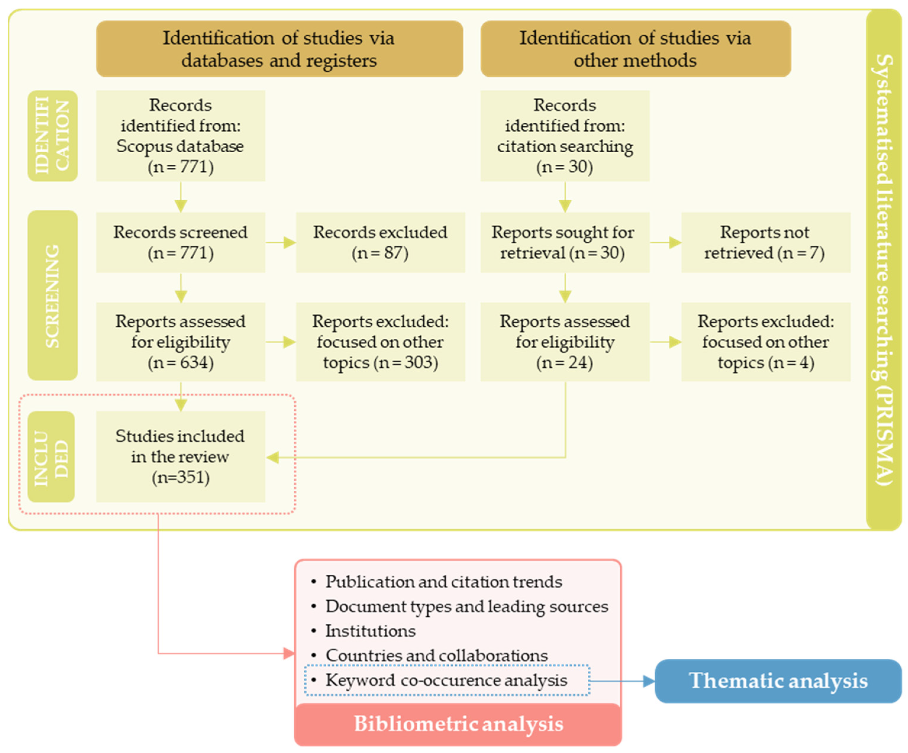
Figure 1. Methodology flowchart.
Drones 09 00692 g001
Figure 2. Publication trend of the reviewed manuscripts compared to (a) the total number of documents published on UAM and (b) the citation trend.
Drones 09 00692 g002
Figure 3. (a) Most relevant sources according to the number of papers published; (b) distribution of the main sources.
Drones 09 00692 g003
Figure 4. Most relevant institutions based on the number of publications.
Drones 09 00692 g004
Figure 5. Most relevant countries based on (a) number of papers referred to the affiliations of all the authors; (b) number of papers referred to the affiliation of the corresponding author; (c) number of total citations. SCP stands for single-country papers, MCP stands for multiple-country papers.
Drones 09 00692 g005
Figure 6. Co-authorship network of countries.
Drones 09 00692 g006
Figure 7. Keyword co-occurrence map.
Drones 09 00692 g007
Table 1. Number of publications per year and Annual Growth Rate (AGR).
YearN. of PublicationsAnnual Growth Rate
20100-
20110-
20120-
20130-
20140-
20150-
20163-
201730.0%
20189200.0%
201918100.0%
20203277.8%
20215262.5%
202251−1.9%
20239280.4%
202491−1.1%
Table 2. Most globally cited manuscripts (TC stands for Total Citations).
TitleAuthor, YearJournalTCTC per YearNormalized TC
Urban Air Mobility: History, Ecosystem, Market Potential, and ChallengesCohen et al., 2021 [19]IEEE Transactions on
Intelligent Transportation Systems
26052.0010.97
An overview of current research and developments in urban air mobility—Setting the scene for UAM introductionStraubinger et al., 2020 [18]Journal of Air Transport Management28747.839.90
Urban air mobility: A comprehensive review and comparative analysis with autonomous and electric ground transportation for informing future researchGarrow et al., 2021 [2]Transportation Research Part C: Emerging
Technologies
23346.609.83
U-Space Concept of Operations: A Key Enabler for Opening Airspace to Emerging Low-Altitude OperationsBarrado et al., 2020 [44]Aerospace14724.505.07
Loose and Tight GNSS/INS Integrations: Comparison of Performance Assessed in Real Urban ScenariosFalco et al., 2017 [45]Sensors19621.782.19
Ground Risk Map for Unmanned Aircraft in Urban EnvironmentsPrimatesta et al., 2020 [46]Journal of Intelligent & Robotic Systems11419.003.93
A Risk-Aware Path Planning Strategy for UAVs in Urban EnvironmentsPrimatesta et al., 2019 [47]Journal of Intelligent & Robotic Systems10915.573.12
On the understanding of the current status of urban air mobility development and its future prospects: Commuting in a flying vehicle as a new paradigmPons-Prats et al., 2022 [32]Transportation Research Part E: Logistics and Transportation
Review
6015.005.13
Integrated Network Design and Demand Forecast for On-Demand Urban Air MobilityWu and Zhang, 2021 [48]Engineering7114.202.99
Potential Urban Air Mobility Travel Time Savings: An Exploratory Analysis of Munich, Paris, and San FranciscoRothfeld et al., 2021 [10]Sustainability7014.002.95
Table 3. Main information about the authors (elaborated with Biblioshiny).
DescriptionResults
Authors
Authors1071
Authors of single-authored docs18
Authors collaboration
Single-authored docs19
Co-Authors per Doc4.03
International co-authorships %14.53%
Disclaimer/Publisher’s Note: The statements, opinions and data contained in all publications are solely those of the individual author(s) and contributor(s) and not of MDPI and/or the editor(s). MDPI and/or the editor(s) disclaim responsibility for any injury to people or property resulting from any ideas, methods, instructions or products referred to in the content.