4.3. Simulation Experiment of Multi-UAV Path Planning
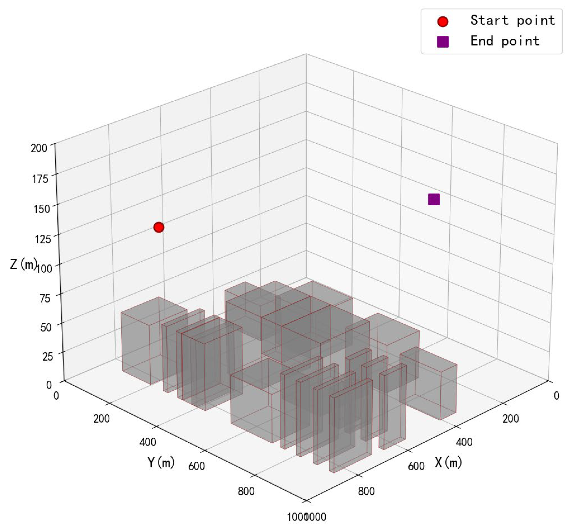
As the density of unmanned aerial vehicles (UAVs) within a unit airspace increases, the resolution of local path conflicts may induce new conflicts. Therefore, the scale of UAVs and the size of the airspace will directly affect the number of conflicts among multiple UAVs. To validate the conflict resolution capability of the proposed algorithm under different UAV scales, simulation experiments were conducted in the same gridded airspace map of 63 × 63 × 13, with obstacles set according to real-world map data. The start and end positions of each UAV were randomly generated within the map. To prevent the proximity of start and end points among UAVs from resulting in non-generalizable path conflict outcomes—which would fail to demonstrate the conflict resolution capability of the proposed method—a certain interval was maintained between randomly generated start points
and end points
, satisfying the condition:
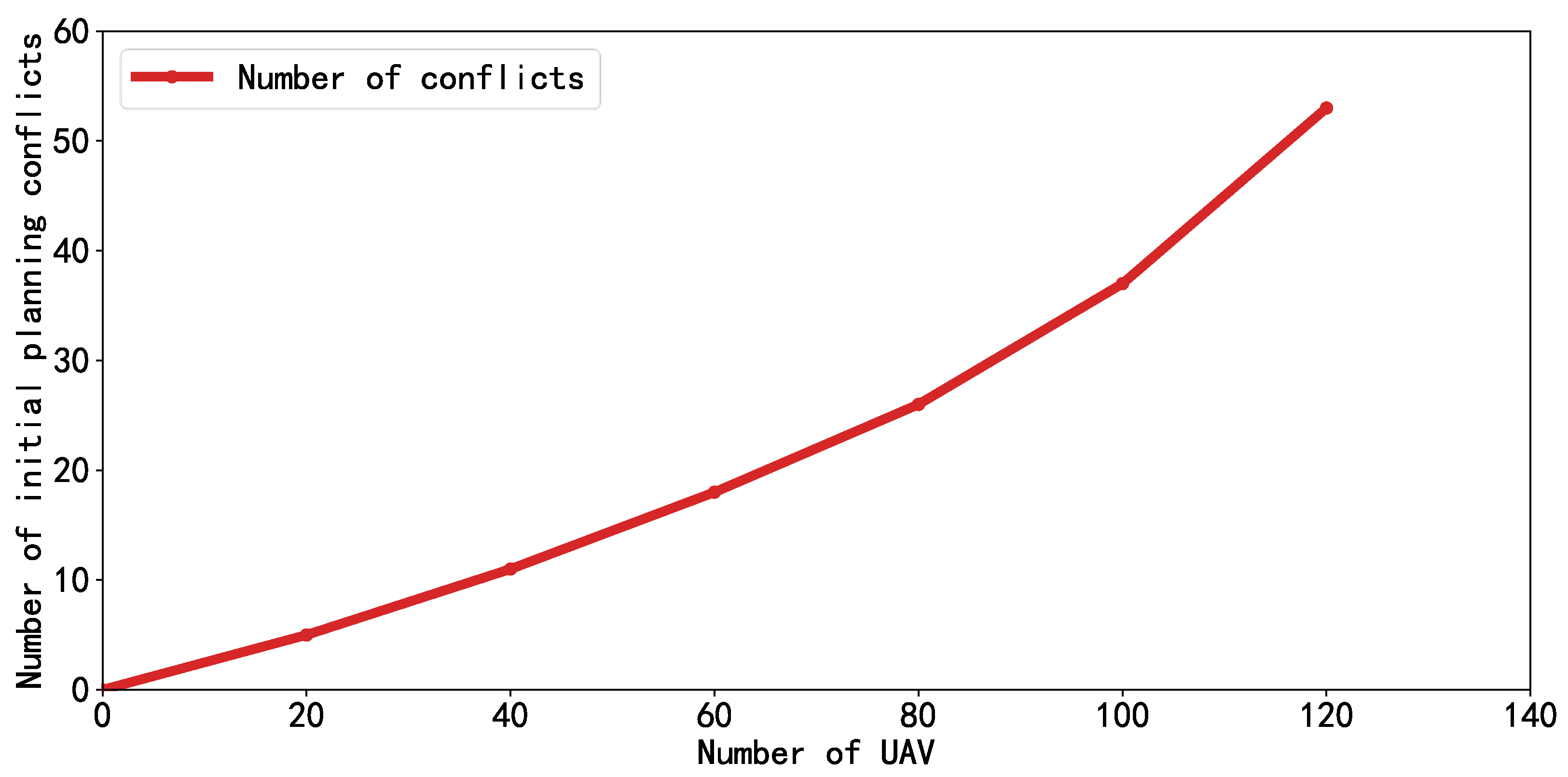
The conflict scenarios under different scales of UAVs are illustrated in
Figure 10. Small-scale UAVs exhibit almost no path conflicts, making conflict resolution relatively easy to achieve. As the scale of UAVs increases, the number of initial path conflicts rises rapidly, leading to increased difficulty in conflict resolution. The binary constraint tree continuously expands, resulting in more iterations of replanning and ultimately prolonging the planning time for conflict resolution.
To further demonstrate the impact of the proposed algorithm on the number of conflict resolution iterations and the quantity of path conflicts in UAV path planning at different scales,
Figure 11 presents the variation curves of conflict count with respect to resolution iterations under various UAV fleet sizes.
When the number of UAVs is relatively small, each iteration resolves one path conflict, as illustrated by the curves for 40 UAVs (blue curve) and 80 UAVs (red curve). The conflict resolution process exhibits a linear decline until all conflicts are resolved. As the scale of UAVs increases, exemplified by the 120-UAV scenario (green curve), the number of conflicts shows slight oscillations during the iterative process—such as at the 12th and 25th iterations—where the conflict count temporarily increases. This phenomenon occurs due to the high density of UAVs in constrained airspace, resulting in strong coupling among planned paths. During conflict resolution via binary tree replanning, the decoupling of one conflict may inadvertently introduce new coupled conflicts, leading to occasional fluctuations in the curve and imposing certain limitations on the algorithm’s conflict resolution capacity. Nevertheless, as the number of iterations increases, the proposed method (DOCBS + IJPS) remains capable of generating constraint-compliant conflict-free paths even for large-scale UAV fleets, thereby validating its overall conflict resolution performance.
The computation time of the algorithm under different UAV fleet sizes is summarized in
Table 4 and illustrated in the bar chart shown in
Figure 12. As indicated by both the table and the figure, the total planning time increases with the number of UAVs. The higher number of conflicts also leads to increased computation time spent on conflict resolution at the upper planning level.
In the case of 120 UAVs, the total planning time reaches 235.3 s, with the conflict resolution and replanning time at the upper layer accounting for 116.18 s, approximately 49.4% (116.18 s/235.3 s) of the total time. On average, each UAV requires about 1.96 s to compute a conflict-free path.
These results demonstrate that the proposed Dual-Objective Conflict-Based Search with Incremental Jump Point Search (DOCBS + IJPS) method exhibits effective conflict resolution capability and efficient computational performance across different UAV fleet scales.
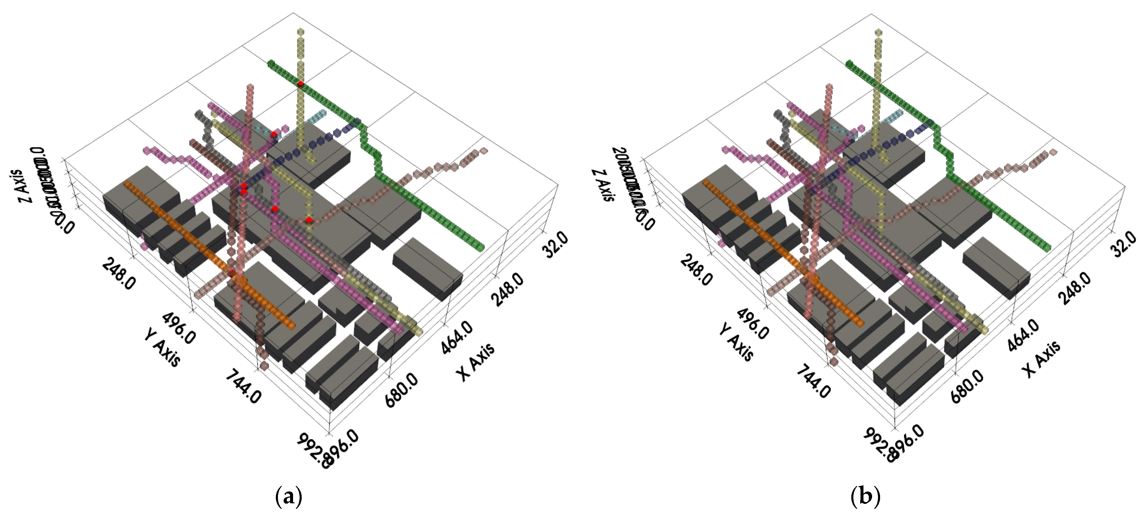
A comparison of flight paths before and after conflict resolution is shown in
Figure 13.
Figure 13a displays the conflicting flight paths in a scenario involving 120 drones, visualized using Python. The flight paths are represented by semi-transparent grid nodes in different colors, with red nodes indicating conflict points. After conflict detection, path conflict resolution was performed to replan the paths of the conflicting drones. The results, presented in
Figure 13b, show that the newly planned paths contain no conflicts, thereby achieving a globally conflict-free set of flight paths.
To further validate the performance advantages of the proposed DOCBS + IJPS algorithm in large-scale UAV conflict-free path planning, each algorithm was independently executed 10 times under the same simulation map environment. The simulation settings remained consistent with the previous section, utilizing a gridded airspace map of 63 × 63 × 13. As shown in
Table 5, since the proposed method adopts a hierarchical architecture based on the conflict-based search algorithm, the comparative algorithms also followed this framework. The upper-layer planning compared the total planning time to verify the computational efficiency of conflict resolution and replanning, while the lower-layer planning compared the total planned flight distance to evaluate the optimality of the algorithms.
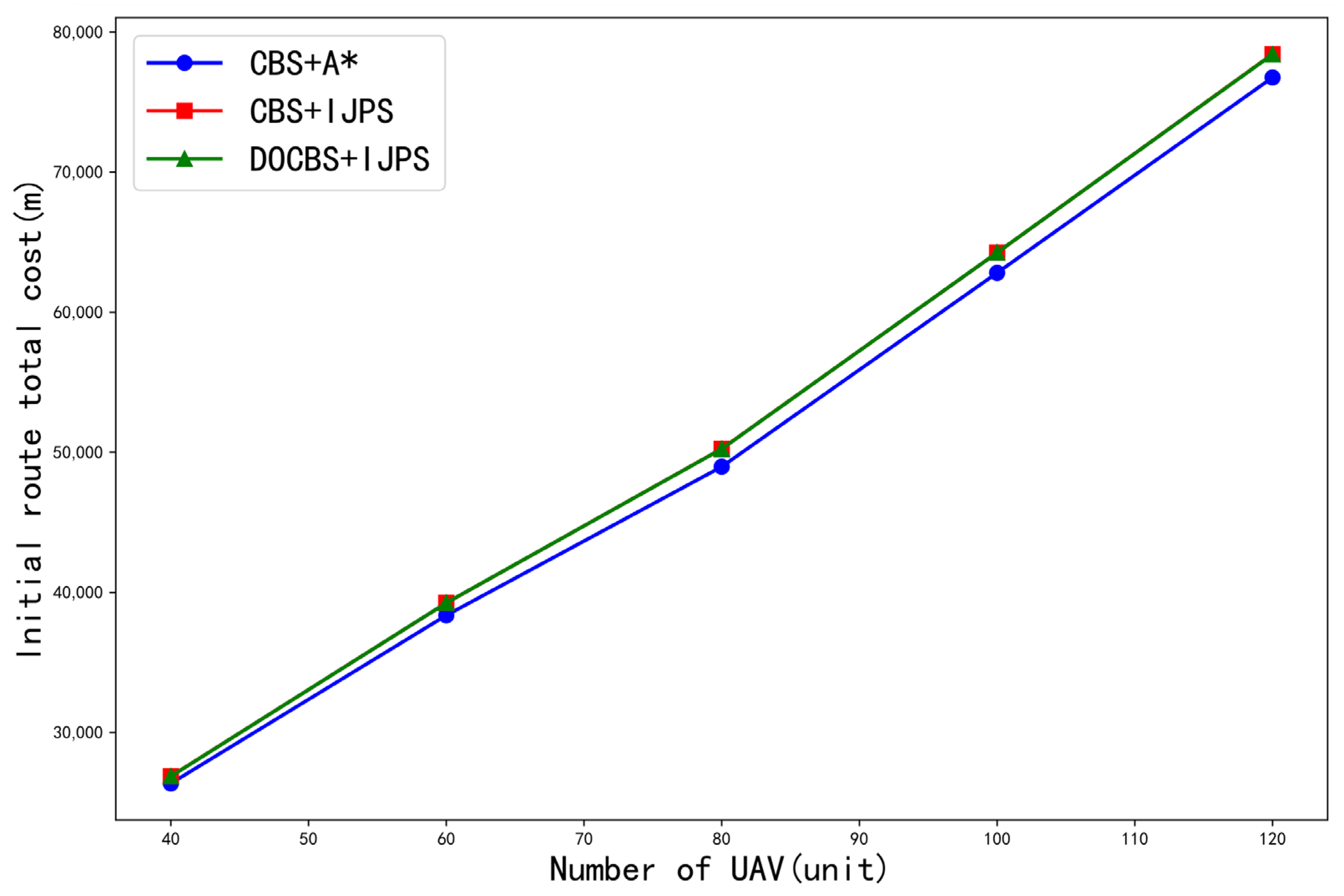
Table 6 summarizes the total path lengths of the initial low-level path planning for three comparison algorithms under different numbers of UAVs, and the corresponding curves are plotted in
Figure 14. Based on the results in
Table 6 and
Figure 14, using the total path length as the metric for evaluating the optimality of conflict-free path solutions, it can be concluded that the CBS + A* method achieves the best optimality, slightly outperforming both the CBS + IJPS and DOCBS + IJPS methods. This is primarily because the A* algorithm generally exhibits slightly better optimality than the JPS algorithm in large-scale maps. Using the total path length of the conventional CBS + A* algorithm as a baseline, the total path length planned by the DOCBS + IJPS algorithm is approximately 2.5% (calculated from the data in
Table 6) longer. Overall, the CBS + IJPS and DOCBS + IJPS methods demonstrate comparable optimality to the CBS + A* method. Due to their shared underlying algorithm, the total path lengths of CBS + IJPS and DOCBS + IJPS are approximately equal, and their optimality performances are consistent.
The computation time results of the three algorithms under different numbers of UAVs are presented in
Table 7 and
Figure 15. All algorithms were tested under the same simulation scenario and parameter settings. All algorithm performance data in this experiment were calculated from the data in
Table 7 and the time consumption for low-level path planning is compared in
Figure 15a. Under the condition that the high-level layer uses the CBS algorithm, the IJPS-based low-level planning method significantly reduces the computation time compared to the A*-based method. Based on the data in
Table 7, the average time consumption is reduced by approximately 25.62% (
). Since both CBS + IJPS and DOCBS + IJPS employ the same underlying planning method, their low-level planning times are nearly identical.
A separate comparison of the high-level conflict resolution time is shown in
Figure 15b. When the high-level layer employs the CBS algorithm, the IJPS algorithm—equipped with an incremental update mechanism—only requires local path replanning, leading to an average reduction in high-level computation time of 20.02% (
) compared to the A* algorithm. Furthermore, when the low-level planner uses IJPS in both cases, the DOCBS method reduces the number of conflict resolution iterations and decreases the frequency of replanning calls compared to the conventional CBS method, resulting in an additional 27.94% (
) average reduction in high-level computation time. Moreover, as the number of UAVs and conflicts increases, the extent of time reduction becomes more pronounced.
From the perspective of the two-layer planning framework, the total planning time is shown in
Figure 15c,d. The DOCBS + IJPS method achieved the shortest computation time for generating conflict-free paths in large-scale drone scenarios. Compared to the CBS + A* and CBS + IJPS methods, it reduced the average planning time by 35.56% (
) and 17.02% (
), respectively. However, considering the total range, adopting an incremental update mechanism increases the total range by about 2.5% (calculated from the data in
Table 6), sacrificing a small part of optimality to achieve a huge improvement in computational efficiency. The simulation results demonstrate the significant computational efficiency advantages of the proposed DOCBS + IJPS method.

