Monitoring the Impact of Urban Development on Archaeological Heritage Using UAV Mapping: A Framework for Preservation and Urban Growth Management
Abstract
Highlights
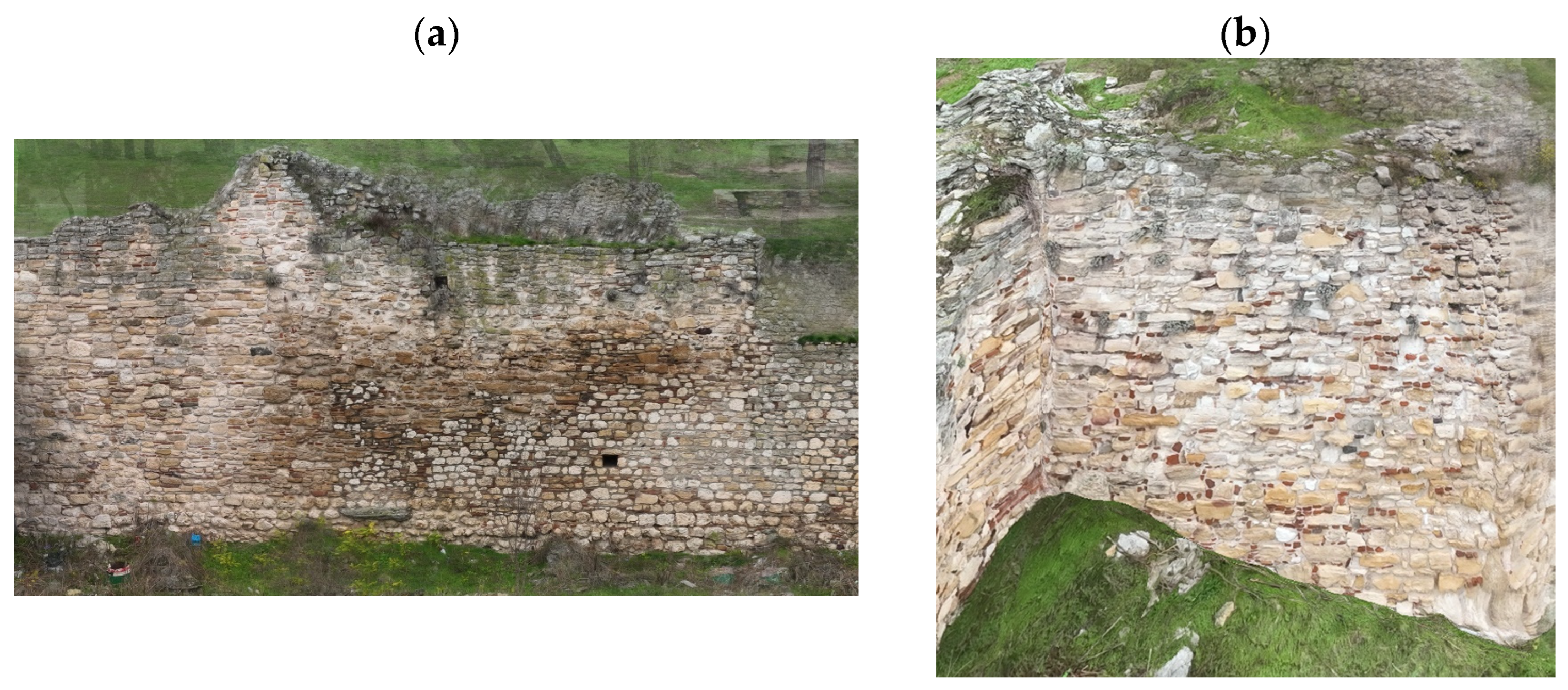
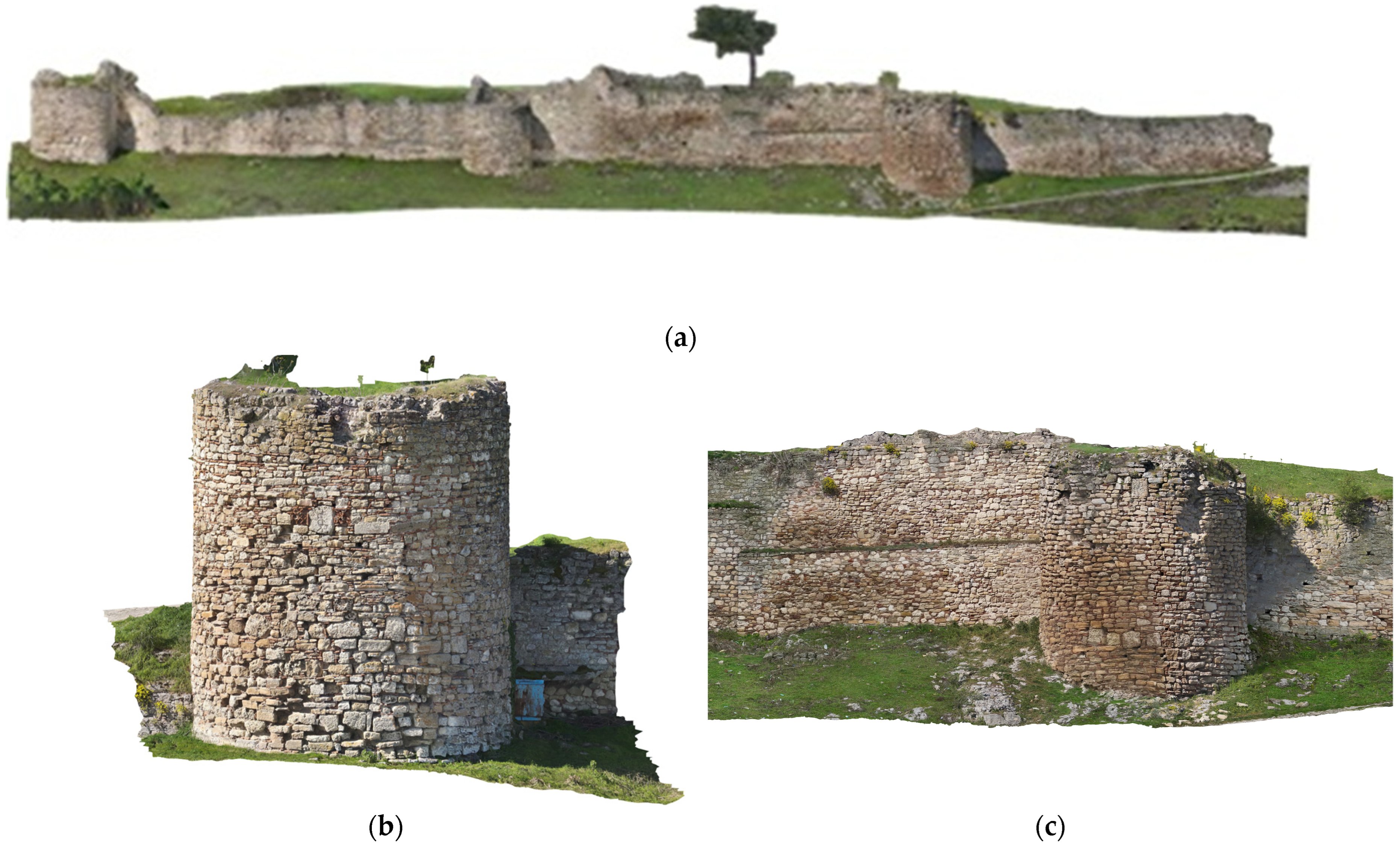
- UAV photogrammetry enabled detailed mapping and 3D modelling of the Didy-moteicho Fortress within a complex urban environment.
- The method successfully identified vulnerabilities and urban development pressures on the archaeological site.
- UAV-based surveys provide a practical, accurate, and non-invasive approach for monitoring and documenting heritage sites in cities.
- The approach can support policy-making and enhance conservation planning in historic urban areas.
Abstract
1. Introduction
1.1. The Limitations of Traditional Monitoring Approaches
1.2. UAV-Based Mapping and 3D Modelling in Urban Archaeology
1.3. Global Applications and Policy Integration of UAV Data
1.4. A Methodological Framework
2. Materials and Methods
2.1. Study Area
2.2. UAV Technology and Equipment
2.3. Data Acquisition
2.4. Data Processing Workflow
2.5. Quality Indexes
3. Results
3.1. UAV 3D Mapping Outputs
3.2. Correlation Between Urban Growth and Cultural Heritage Management and Assessment
4. Discussion
- 1.
- Digital documentation of the monument: Produce high-resolution UAV-based mapping and 3D modelling of the archaeological site under study and its immediate environment. This provides a precise and up-to-date record of the site’s condition and spatial context.
- 2.
- Assessment of current condition: Analysis of the structural state of the monument and surrounding landscape, identifying signs of deterioration, structural vulnerabilities, and external pressures such as vegetation overgrowth or nearby construction.
- 3.
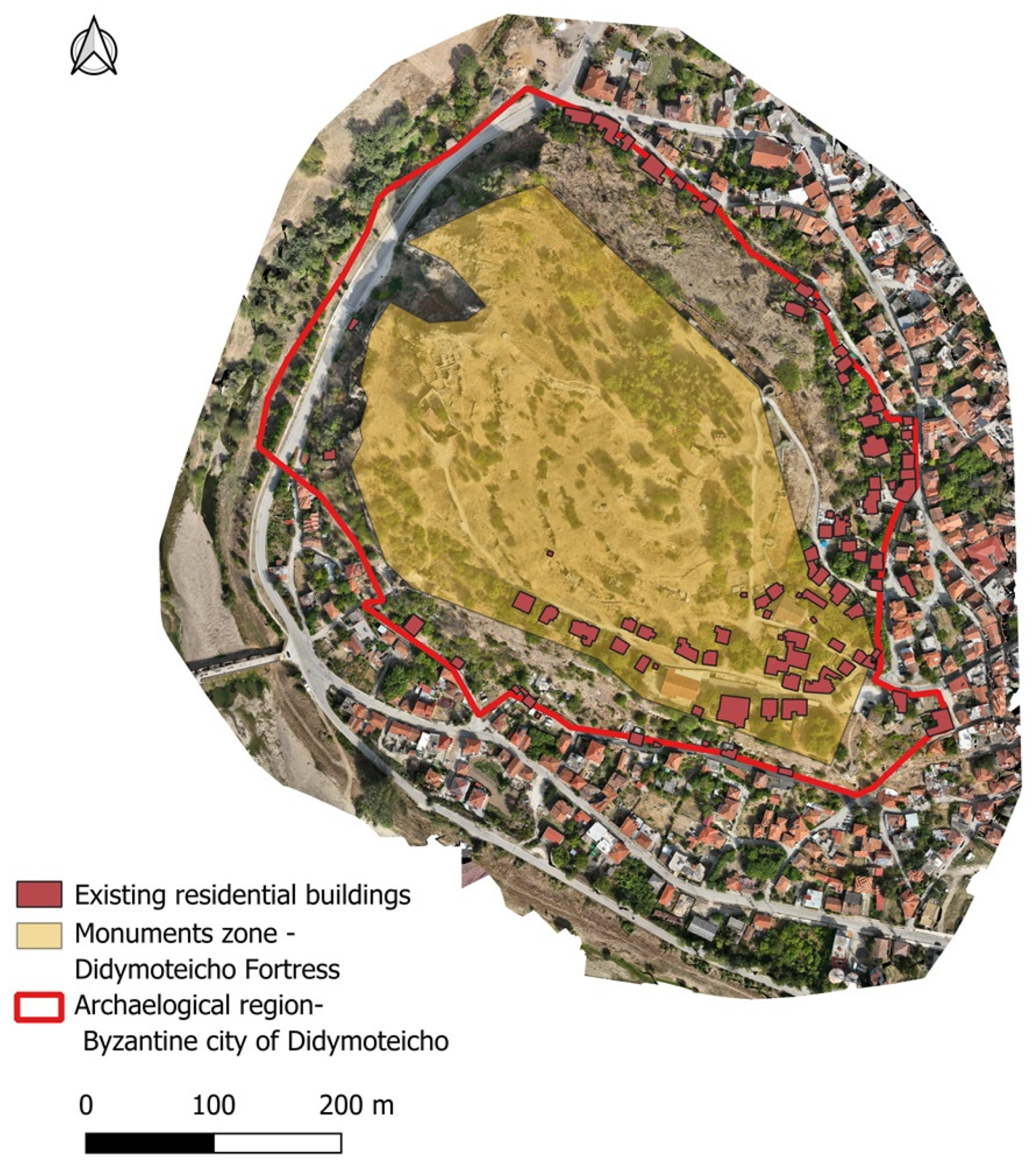
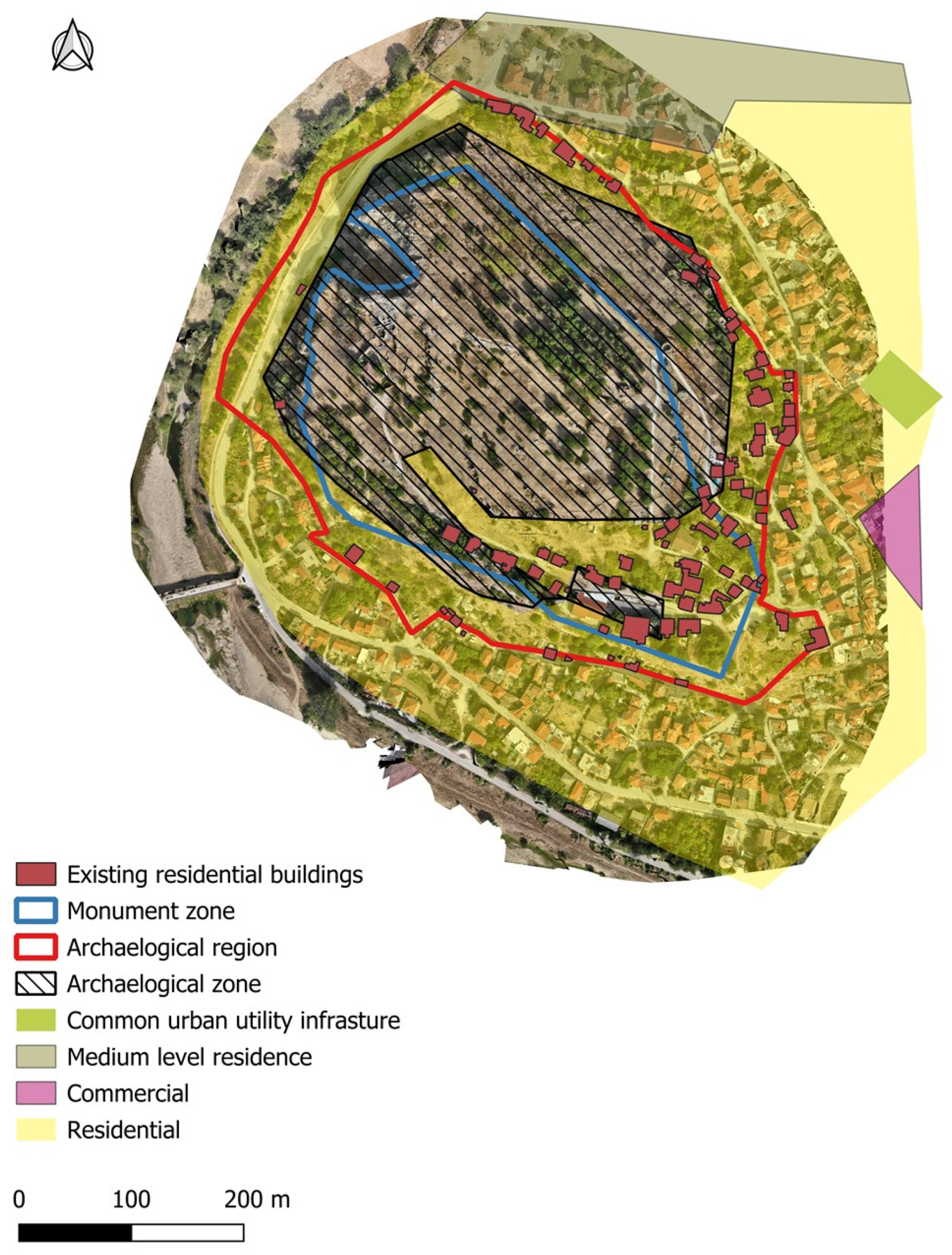
- Spatial analysis and regulatory comparison: Overlaying the generated spatial data with the official zones defined by the Archaeological Cadastre (e.g., monument zone and archaeological protection zone) to assess compliance and detect unauthorized developments. A key advantage of this approach is that all UAV-derived products are georeferenced, enabling overlays and regulatory comparisons to be performed automatically within GIS. This automation reduces the need for manual interpretation, minimizes errors, and accelerates the detection of encroachments or unauthorized developments. As a result, the framework becomes not only more efficient and accurate but also highly transferable to other heritage sites and urban contexts.
- 4.
- Identification of critical areas: Highlight areas where modern settlements or illegal structures intersect with protected zones, particularly within the monument boundaries, prioritizing these areas for intervention.
- 5.
- Engagement with local authorities: Present findings to municipal and regional authorities, providing visual and spatial evidence to support enforcement of heritage regulations and the integration of heritage into local planning processes.
- 6.
- Awareness and community involvement: Develop outreach initiatives to raise public awareness of the monument’s historical significance, the threats it faces, and the importance of its preservation. This could include educational materials, exhibitions, or community workshops.
- 7.
- Establishment of a monitoring system: Propose a long-term digital monitoring framework using periodic UAV surveys and GIS-based change detection to track alterations in land use, new constructions, or environmental degradation around the site.
5. Conclusions
Author Contributions
Funding
Data Availability Statement
Conflicts of Interest
References
- UNESCO. Culture: Urban Future; Global Report on Culture for Sustainable Urban Development; Summary; United Nations Educational, Scientific and Cultural Organization: Paris, France, 2016. [Google Scholar]
- Tabrizi, S.K.; Abdelmonem, M.G. Contemporary construction in historical sites: The missing factors. Front. Archit. Res. 2024, 13, 487–504. [Google Scholar] [CrossRef]
- Jigyasu, R. Reducing Disaster Risks to Urban Cultural Heritage: Global Challenges and Opportunities. J. Herit. Manag. 2016, 1, 59–67. [Google Scholar] [CrossRef]
- UNESCO. Recommendation on the Historic Urban Landscape. Available online: https://whc.unesco.org/en/hul/ (accessed on 9 April 2025).
- Alessandri, C. (Ed.) The Restoration of the Nativity Church in Bethlehem, 1st ed.; CRC Press: Boca Raton, FL, USA, 2020. [Google Scholar] [CrossRef]
- Regnauld, N.; Mackaness, W.A.; Hart, G. Automated relief representation for visualisation of archaeological monuments and other anthropogenic forms. Comput. Environ. Urban Syst. 2002, 26, 219–239. [Google Scholar] [CrossRef]
- Sestras, P.; Badea, G.; Badea, A.C.; Salagean, T.; Roșca, S.; Kader, S.; Remondino, F. Land surveying with UAV photogrammetry and LiDAR for optimal building planning. Autom. Constr. 2025, 173, 106092. [Google Scholar] [CrossRef]
- Fekade, W. Deficits of formal urban land management and informal responses under rapid urban growth, an international perspective. Habitat Int. 2000, 24, 127–150. [Google Scholar] [CrossRef]
- Bashandy, S.Y.H.; Abd Elaziz, N. Urban Heritage Life Monitoring: As a Proactive Tool for Sustainable Heritage Areas. J. Eng. Appl. Sci. 2020, 67, 2033–2052. [Google Scholar]
- Zan, L.; Baraldi, S.B.; Gordon, C. Cultural Heritage Between Centralisation and Decentralisation: Insights from the Italian context. Int. J. Cult. Policy 2007, 13, 49–70. [Google Scholar] [CrossRef]
- Soleymani, A.; Jahangir, H.; Nehdi, M.L. Damage detection and monitoring in heritage masonry structures: Systematic review. Constr. Build. Mater. 2023, 397, 132402. [Google Scholar] [CrossRef]
- Bandarin, F.; Van Oers, R. The Historic Urban Landscape: Managing Heritage in an Urban Century; Wiley: Hoboken, NJ, USA, 2012. [Google Scholar] [CrossRef]
- Nikolakopoulos, K.G.; Soura, K.; Koukouvelas, I.K.; Argyropoulos, N.G. UAV vs classical aerial photogrammetry for archaeological studies. J. Archaeol. Sci. Rep. 2017, 14, 758–773. [Google Scholar] [CrossRef]
- Treccani, D.; Adami, A.; Fregonese, L. Drones and Real-Time Kinematic Base Station Integration for Documenting Inaccessible Ruins: A Case Study Approach. Drones 2024, 8, 268. [Google Scholar] [CrossRef]
- Martínez-Espejo Zaragoza, I.; Caroti, G.; Piemonte, A.; Riedel, B.; Tengen, D.; Niemeier, W. Structure from motion (SfM) processing of UAV images and combination with terrestrial laser scanning, applied for a 3D-documentation in a hazardous situation. Geomat. Nat. Hazards Risk 2017, 8, 1492–1504. [Google Scholar] [CrossRef]
- Jordan, S.; Moore, J.; Hovet, S.; Box, J.; Perry, J.; Kirsche, K.; Lewis, D.; Tse, Z.T.H. State-of-the-art technologies for UAV inspections. IET Radar Sonar Navig 2018, 12, 151–164. [Google Scholar] [CrossRef]
- Woo, H.-J.; Seo, D.-M.; Kim, M.-S.; Park, M.-S.; Hong, W.-H.; Baek, S.-C. Localization of Cracks in Concrete Structures Using an Unmanned Aerial Vehicle. Sensors 2022, 22, 6711. [Google Scholar] [CrossRef] [PubMed]
- Vavulin, M.V.; Chugunov, K.V.; Zaitceva, O.V.; Vodyasov, E.V.; Pushkarev, A.A. UAV-based photogrammetry: Assessing the application potential and effectiveness for archaeological monitoring and surveying in the research on the ‘valley of the kings’ (Tuva, Russia). Digit. Appl. Archaeol. Cult. Herit. 2021, 20, e00172. [Google Scholar] [CrossRef]
- Puerto, A.; Castañeda, K.; Sánchez, O.; Peña, C.A.; Gutiérrez, L.; Sáenz, P. Building information modeling and complementary technologies in heritage buildings: A bibliometric analysis. Results Eng. 2024, 22, 102192. [Google Scholar] [CrossRef]
- Suresh, R.; Nurul, R. Evaluating the Impact of Digital Mapping and 3D Imaging Technologies on the Restoration of Historical Sites in Southeast Asia. Stud. Art Archit. 2024, 3, 1–7. [Google Scholar] [CrossRef]
- Azrour, M.; Baba, K.; Batan, A.; El Rhaffari, Y.; Fratini, F.; Gonzales, F.; Haddad, M.; Ibnoussina, M.; Nounah, A.; Pittaluga, D.; et al. Mediterranean Architectural Heritage—RIPAM10. Mater. Res. Proc. 2024, 40, 33–40. [Google Scholar] [CrossRef]
- Diaz Riveros, C.A.; Cuesta Beleño, A.; Frediani, J.; Rodriguez Tarducci, R.; Cortizo, D. Comparative Analysis of Spatial and Environmental Data in Informal Settlements, from Point Clouds and RPAS Images. In International Conference on Applied Informatics; Florez, H., Leon, M., Eds.; Communications in Computer and Information Science; Springer: Cham, Switzerland, 2023; Volume 1874. [Google Scholar] [CrossRef]
- Hu, D.; Minner, J. UAVs and 3D City Modeling to Aid Urban Planning and Historic Preservation: A Systematic Review. Remote Sens. 2023, 15, 5507. [Google Scholar] [CrossRef]
- Oosterbroek, B.; de Kraker, J.; Huynen, M.; Martens, P.; Verhoeven, K. Assessment of green space benefits and burdens for urban health with spatial modeling. Urban For. Urban Green. 2023, 86, 128023. [Google Scholar] [CrossRef]
- UNESCO. Urban Heritage for Resilience: Consolidated Results of the Implementation of the 2011 Recommendation on the Historic Urban Landscape; 3rd Member States Consultation, United Nations Educational, Scientific and Cultural Organization; UNESCO: Paris, France, 2023. [Google Scholar] [CrossRef]
- Zhou, L.; Yin, H.; Zhao, H.; Wei, J.; Hu, D.; Leung, V. A Comprehensive Survey of Artificial Intelligence Applications in UAV-Enabled Wireless Networks. Digit. Commun. Netw. 2024, in press. [Google Scholar] [CrossRef]
- Pal, O.K.; Shovon, M.S.H.; Mridha, M.F.; Shin, J. In-depth review of AI-enabled unmanned aerial vehicles: Trends, vision, and challenges. Discov. Artif. Intell. 2024, 4, 97. [Google Scholar] [CrossRef]
- Lyu, C.; Lin, S.; Lynch, A.; Zou, Y.; Liarokapis, M. UAV-based deep learning applications for automated inspection of civil infrastructure. Autom. Constr. 2025, 177, 106285. [Google Scholar] [CrossRef]
- Shi, Y.; Wang, W.; Zhang, J.; Li, D.; Liu, F.; Li, W. UAV remote sensing and deep learning for assessing and optimizing architectural texture in traditional villages. npj Herit. Sci. 2025, 13, 325. [Google Scholar] [CrossRef]
- Guzman, P.; Pereira Roders, A. Bridging the gap between urban development and cultural heritage protection. In IAIA14 Conference Proceedings; IAIA14: Viña del Mar, Chile, 2014. [Google Scholar] [CrossRef]
- Labib, N.S.; Brust, M.R.; Danoy, G.; Bouvry, P. The Rise of Drones in Internet of Things: A Survey on the Evolution, Prospects and Challenges of Unmanned Aerial Vehicles. IEEE Access 2021, 9, 115466–115487. [Google Scholar] [CrossRef]
- UNESCO. The Operational Guidelines for the Implementation of the World Heritage Convention. Available online: https://whc.unesco.org/en/guidelines/ (accessed on 9 April 2025).
- Ginzarly, M.; Houbart, C.; Teller, J. The Historic Urban Landscape approach to urban management: A systematic review. Int. J. Herit. Stud. 2018, 25, 1–21. [Google Scholar] [CrossRef]
- De Fino, M.; Galantucci, R.A.; Fatiguso, F. Condition Assessment of Heritage Buildings via Photogrammetry: A Scoping Review from the Perspective of Decision Makers. Heritage 2023, 6, 7031–7066. [Google Scholar] [CrossRef]
- Buragohain, D.; Meng, Y.; Deng, C.; Li, Q.; Chaudhary, S. Digitalizing cultural heritage through metaverse applications: Challenges, opportunities, and strategies. Herit. Sci. 2024, 12, 295. [Google Scholar] [CrossRef]
- Zavagno, L.; Bakirtzis, N. The Routledge Handbook of the Byzantine City. In The Routledge Handbook of the Byzantine City From Justinian to Mehmet II (Ca. 500–Ca.1500); Routledge Publishing: Abingdon-on-Thames, Oxfordshire, UK, 2024; ISBN 9780367196790. [Google Scholar]
- Kastropolites Didymoteixou. Available online: https://kastropolites.com/didym-otoman-arsiv-history/ (accessed on 1 September 2025).
- National Archive of Monuments, Greece. Available online: https://www.arxaiologikoktimatologio.gov.gr/en (accessed on 20 November 2024).
- e-Poleodomia, Urban Regulations Bureau, Greece. Available online: http://gis.epoleodomia.gov.gr/v11/index.html#/25.0814/40.6279/9 (accessed on 20 November 2024).
- Tapete, D.; Cigna, F. Trends and perspectives of space-borne SAR remote sensing for archaeological landscape and cultural heritage applications. J. Archaeol. Sci. Rep. 2017, 14, 716–726. [Google Scholar] [CrossRef]
- Remondino, F.; Spera, M.G.; Nocerino, E.; Menna, F.; Nex, F. State of the art in high density image matching. Photogram Rec. 2014, 29, 144–166. [Google Scholar] [CrossRef]
- Ngeljaratan, L.; Bas, E.E.; Moustafa, M.A. Unmanned Aerial Vehicle-Based Structural Health Monitoring and Computer Vision-Aided Procedure for Seismic Safety Measures of Linear Infrastructures. Sensors 2024, 24, 1450. [Google Scholar] [CrossRef]
- Plevris, V.; Papazafeiropoulos, G. AI in Structural Health Monitoring for Infrastructure Maintenance and Safety. Infrastructures 2024, 9, 225. [Google Scholar] [CrossRef]
- Butt, N.u.S.Z.; Wang, X.; Luo, L.; Ul Hussan, H. Evaluating the Impact of Urban Encroachment and Land Cover Changes on World Cultural Heritage Site Taxila: A Spatio-Temporal Analysis from 1990 to 2024. Sustainability 2025, 17, 1059. [Google Scholar] [CrossRef]
- Papakonstantinou, A.; Kavroudakis, D.; Kourtzellis, Y.; Chtenellis, M.; Kopsachilis, V.; Topouzelis, K.; Vaitis, M. Mapping Cultural Heritage in Coastal Areas with UAS: The Case Study of Lesvos Island. Heritage 2019, 2, 1404–1422. [Google Scholar] [CrossRef]
- Zachos, A.; Anagnostopoulos, C.N. Using TLS, UAV, and MR Methodologies for 3D Modelling and Historical Recreation of Religious Heritage Monuments. ACM J. Comput. Cult. Herit. 2024, 17, 1–23. [Google Scholar] [CrossRef]


| Type | |
|---|---|
| UAV | DJI Mavic 3 Enterprise |
| F-stop | f/2.8 |
| Camera model | M3M_12.3_5280 × 3956 (RGB) |
| Flight height | 92.4 m above ground level—autonomous 16.5 m above ground level—manual north part 18.9 m above ground level—manual south part |
| Geolocation Error X [%] | Geolocation Error Y [%] | Geolocation Error Z [%] | |
|---|---|---|---|
| Mean Error (m) | 0.000019 | 0.000116 | 0.007624 |
| St. Deviation σ (m) | 0.007624 | 0.008979 | 0.074787 |
| RMS Error (m) | 0.007624 | 0.008980 | 0.074787 |
| X | Y | Z | |
|---|---|---|---|
| Mean Error (m) | 0.035 | 0.030 | 0.055 |
| St. Deviation σ (m) | 0.032 | 0.028 | 0.047 |
| RMSE (m) | 0.047 | 0.041 | 0.072 |
| Type | |
|---|---|
| Number of 2D Key point Observations for Bundle Block Adjustment | 32,709,016 |
| Number of 3D Points for Bundle Block Adjustment | 10,077,149 |
| Mean Reprojection Error [pixels] | 0.187 |
| Overlap | 5 images per pixel/80% forward and 70% side overlap |
Disclaimer/Publisher’s Note: The statements, opinions and data contained in all publications are solely those of the individual author(s) and contributor(s) and not of MDPI and/or the editor(s). MDPI and/or the editor(s) disclaim responsibility for any injury to people or property resulting from any ideas, methods, instructions or products referred to in the content. |
© 2025 by the authors. Licensee MDPI, Basel, Switzerland. This article is an open access article distributed under the terms and conditions of the Creative Commons Attribution (CC BY) license (https://creativecommons.org/licenses/by/4.0/).
Share and Cite
Tsifodimou, Z.E.; Skondras, A.; Stamou, A.; Skalidi, I.; Tavantzis, I.; Stylianidis, E. Monitoring the Impact of Urban Development on Archaeological Heritage Using UAV Mapping: A Framework for Preservation and Urban Growth Management. Drones 2025, 9, 669. https://doi.org/10.3390/drones9100669
Tsifodimou ZE, Skondras A, Stamou A, Skalidi I, Tavantzis I, Stylianidis E. Monitoring the Impact of Urban Development on Archaeological Heritage Using UAV Mapping: A Framework for Preservation and Urban Growth Management. Drones. 2025; 9(10):669. https://doi.org/10.3390/drones9100669
Chicago/Turabian StyleTsifodimou, Zoi Eirini, Alexandros Skondras, Aikaterini Stamou, Ifigeneia Skalidi, Ioannis Tavantzis, and Efstratios Stylianidis. 2025. "Monitoring the Impact of Urban Development on Archaeological Heritage Using UAV Mapping: A Framework for Preservation and Urban Growth Management" Drones 9, no. 10: 669. https://doi.org/10.3390/drones9100669
APA StyleTsifodimou, Z. E., Skondras, A., Stamou, A., Skalidi, I., Tavantzis, I., & Stylianidis, E. (2025). Monitoring the Impact of Urban Development on Archaeological Heritage Using UAV Mapping: A Framework for Preservation and Urban Growth Management. Drones, 9(10), 669. https://doi.org/10.3390/drones9100669


