Article

Monitoring the Impact of Urban Development on Archaeological Heritage Using UAV Mapping: A Framework for Preservation and Urban Growth Management

by
Zoi Eirini Tsifodimou
,
Alexandros Skondras
*,
Aikaterini Stamou
*,
Ifigeneia Skalidi
,
Ioannis Tavantzis
and
Efstratios Stylianidis
School of Spatial Planning and Development, Faculty of Engineering, Aristotle University of Thessaloniki (AUTh), University Campus, 54124 Thessaloniki, Greece
*
Authors to whom correspondence should be addressed.
Drones 2025, 9(10), 669; https://doi.org/10.3390/drones9100669
Submission received: 11 July 2025 / Revised: 17 September 2025 / Accepted: 21 September 2025 / Published: 24 September 2025
(This article belongs to the Special Issue Implementation of UAV Systems for Cultural Heritage)

Abstract

Highlights

What are the main findings?
  • UAV photogrammetry enabled detailed mapping and 3D modelling of the Didy-moteicho Fortress within a complex urban environment.
  • The method successfully identified vulnerabilities and urban development pressures on the archaeological site.
What is the implication of the main finding?
  • UAV-based surveys provide a practical, accurate, and non-invasive approach for monitoring and documenting heritage sites in cities.
  • The approach can support policy-making and enhance conservation planning in historic urban areas.

Abstract

Urbanization poses growing threats to archaeological heritage sites embedded within cities, necessitating innovative monitoring and documentation strategies. This study investigates the use of Unmanned Aerial Vehicle (UAV) photogrammetry for mapping and 3D modelling of urban archaeological landscapes, focusing on the Byzantine-era Didymoteicho Fortress in northern Greece. High-resolution aerial imagery was captured and processed into an orthophoto mosaic and a detailed 3D model of the site’s monuments and their urban surroundings. The UAV-based survey provided comprehensive, up-to-date spatial data that traditional ground methods could not easily achieve in dense urban settings. The results illustrate how UAV mapping can document complex heritage structures, detect risks (such as structural deterioration or encroachment by development), and inform preservation efforts. The discussion situates these findings within global heritage management practices, highlighting UAV technology as a cost-effective, accurate, and non-invasive tool for safeguarding cultural heritage in urban areas. The suggested methodology enhances heritage documentation and risk assessment, demonstrating strong potential for policy integration and proactive conservation planning in historic cities.

1. Introduction

Rapid urban growth is increasingly encroaching upon archaeological sites in cities, creating unprecedented pressures on cultural heritage. The expansion of infrastructure and uncontrolled development around historic areas can lead to physical damage, vibration impact, pollution, and changes in land use that threaten the integrity of ancient structures. With over half of the world’s population living in cities, the urgency to protect urban heritage amid development demands is intensified [1]. Historic urban settlements are not static relics; they form part of living cities and often become centers and drivers of economic growth. Nonetheless, this growth brings along complex challenges for conservation; modern buildings and utilities may be constructed adjacent to, or even atop, archaeological layers [2]. Inadequate urban planning and weak enforcement of protective regulations exacerbate risks, resulting in loss of context and fabric of heritage sites [3]. For example, construction projects in historic quarters can undermine ancient foundations or alter the skyline in ways that diminish a site’s historic character [2]. These threats highlight the need for balanced strategies that accommodate urban development while preserving cultural heritage values. Globally, policy frameworks such as UNESCO’s Historic Urban Landscape (HUL) Recommendation [4] call for integrating heritage conservation into urban planning to manage change sustainably. In practice, however, achieving this integration remains challenging, as cultural heritage management and urban development often operate in separate silos. The consequence is that archaeological heritage in urban areas frequently lacks systematic monitoring and is vulnerable to gradual degradation, caused by not only human interventions but also by extreme weather factors. This consequence underscores why improved documentation and monitoring tools are critical in urban archaeological sites facing urban development pressures.

1.1. The Limitations of Traditional Monitoring Approaches

Conventional heritage monitoring and documentation methods in urban settings have significant limitations that hinder timely conservation action. Traditionally, site inspections are conducted through periodic field surveys, manual measurements, and fixed photographic records taken from the ground or scaffolds [5]. These approaches are labor-intensive, time-consuming, and often provide only fragmented snapshots of site conditions. Two-dimensional maps and hand-drawn plans have long been used to record monuments [6], but they may omit subtle changes or small-scale damage that accumulate over time. Ground-based photography and surveys struggle to capture the full extent of large or complex structures, especially in dense urban environments where access and vantage points are limited [7]. As a result, critical issues such as minute structural shifts, early signs of wall buckling, or unauthorized building encroachments can go unnoticed until they escalate into serious problems [8]. Furthermore, traditional monitoring lacks the frequency and agility needed to keep pace with rapid urban changes [9]. Heritage authorities often have constrained staff and budgets, leading to inspections at multi-year intervals [10]. In fast-changing city landscapes, significant alterations or damages might occur between inspections. Static monitoring systems (like fixed sensors on the structures) can assist but are usually costly and suffer from the risk of detachment or dislocation and usually lack the ability to identify newly created and fine architectural details or hairline cracks in historic masonry [11]. The absence of high-resolution, up-to-date data impedes informed decision-making. In many cases, conservation interventions are reactive (as in undertaken only after visible deterioration or incidents) rather than preventive. Ultimately, the limitations of traditional methods create a gap in heritage management: sites in urban areas are insufficiently documented and monitored [12], undermining proactive conservation. This gap has prompted researchers and practitioners to explore new technologies that can augment or replace conventional techniques, offering more comprehensive and timelier site information.

1.2. UAV-Based Mapping and 3D Modelling in Urban Archaeology

The arrival of UAV (drone) technology has revolutionized the way researchers document and monitor cultural heritage, especially in complex urban environments. UAV photogrammetry enables rapid collection of high-resolution aerial imagery at various angles, which can be processed into detailed orthophotos, terrain models, and textured 3D reconstructions of archaeological sites [13]. Unlike traditional ground surveys, drones can safely and quickly access hard-to-reach areas [14], flying over ruins and modern structures alike to capture a complete visual record. This capability was a big leap in technology for survey engineering and heritage documentation. By feeding UAV-acquired images into structure-from-motion (SfM) photogrammetric software (Agisoft Metashape 2.1.1, Pix4D Mapper 4.8.4), practitioners obtain photorealistic 3D models and accurate spatial measurements of monuments and their surroundings [15]. These models allow for virtual inspection of structural conditions and can be compared over time for change detection. UAV mapping is also far more time and cost efficient than extensive scaffold inspections or terrestrial laser scanning, particularly in urban sites where deploying bulky equipment is disruptive [16]. Moreover, drones introduce minimal physical impact on sensitive sites, an important advantage for preserving the site’s integrity during documentation.
Studies have demonstrated that integrating UAV data yields highly accurate outputs suitable for rigorous analysis and achieving mm-level accuracy in 3D models by combining UAV imagery with relative position between objects in UAV-captured images to significantly reduce the error level [17], enabling precise damage assessment and restoration planning. In archaeology, UAV-based surveys increasingly complement excavations and conventional recording, creating rich spatial datasets that can be analyzed in GIS for mapping archaeological features in their broader urban context [18]. Notably, UAV-derived orthophoto maps provide a current ground plan of sites, which is invaluable in fast-changing urban settings where existing maps may be outdated or imprecise. Consequently, UAV technology offers a transformative toolkit for urban heritage management since it produces comprehensive and up-to-date documentation, enhances visualization through 3D models, and supports quantitative analyses (such as calculating areas, volumes, or rates of change) that were previously difficult to obtain with traditional methods [19]. These capabilities directly address the documentation gaps in urban heritage monitoring, enabling more proactive and informed conservation practices.

1.3. Global Applications and Policy Integration of UAV Data

Given these advantages, UAV-based documentation has been rapidly adopted in cultural heritage projects worldwide, including urban contexts. Around the globe, heritage professionals are leveraging drones to survey historic city centers, archaeological parks within cities, and monuments in densely built-up areas. Examples span from mapping ancient temples amid modern development in Asia [20], to surveying medieval city fortifications in Europe [21], to documenting pre-Columbian sites encroached by informal settlements in Latin America [22]. This global uptake is reflected in a surge of scholarly research on UAV applications in archaeology and heritage preservation over the last decade [23]. Researchers highlight not only technical success stories but also the importance of integrating these new datasets into decision-making processes for urban planning and heritage management. Ever more, high-resolution 3D city models derived from drones are used to inform urban development plans [24], ensuring that new constructions respect sightlines and buffer zones of historic sites. In Latin America and the Caribbean, planning authorities require or utilize digital heritage documentation (including UAV surveys) before approving development near protected monuments [25]. Recent research emphasizes the growing application of artificial intelligence and machine learning (ML) in UAV data analysis [26,27]. In infrastructure inspection, deep learning pipelines are increasingly used to process UAV imagery for automated damage detection [28], while in cultural heritage, tailored models support the analysis of traditional village structures [29]. Together, these developments point to a broader trend toward domain-specific workflows, real-time onboard inference, and the integration of multisensor UAV data with advanced ML techniques. However, challenges remain in fully institutionalizing these practices. As Guzmán et al. note, bridging the gap between urban development and heritage protection is far from being a common practice [30]. Many heritage managers and urban planners are still exploring how best to share and use UAV-generated data. Key hurdles include the lack of standardized protocols for data exchange, questionable security, privacy and data protection, and concerns about data accuracy or legal restrictions on drone flights in cities [31]. Nevertheless, international frameworks are evolving to accommodate these tools. UNESCO’s World Heritage Centre [32], for instance, has encouraged State Parties to employ advanced documentation technologies for sites in urban contexts. The Historic Urban Landscape approach explicitly calls for modern spatial information systems and continuous monitoring as part of managing change in historic cities [33]. UAV surveys can feed into heritage building assessments [34] by providing up-to-date visuals and metrics to evaluate how new projects might affect a site. They also offer a way to engage the public and stakeholders: interactive 3D models and fly-through videos generated from drone data can raise awareness of heritage values and threats, building support for conservation-friendly policies [35]. Finally, UAV-based mapping has proven its worth in diverse global case studies and is gradually being woven into heritage management policies. The continued expansion of these applications will depend on interdisciplinary collaboration, bringing together archaeologists, conservation specialists, urban planners, and policymakers to ensure that rich UAV datasets directly inform the sustainable development of historic urban landscapes.

1.4. A Methodological Framework

This research adopts a comprehensive methodological framework aimed at monitoring the effects of urban development on archaeological heritage using UAV-based 3D mapping techniques, in Didymoteicho, Greece. Didymoteicho is a small city located in northeastern Greece, near the border with Turkey. Despite its strategic location and rich historical significance, it stands as a representative case of peripheral urban areas in Greece, which frequently suffer from a lack of comprehensive and consistent urban planning frameworks. One of the city’s most important cultural landmarks is its Byzantine fortress, a monument of great historical and architectural value. However, the wall is currently in a neglected state, surrounded by urban development, residential buildings are built dangerously close to its base, and natural overgrowth, including trees and invasive vegetation (Figure 1 and Figure 2). No comprehensive conservation or promotion plan exists to protect or integrate the monument into the city’s cultural and touristic profile. In this context, our work focused on documenting and measuring the fortress, assessing its current condition, and identifying the various environmental and anthropogenic pressures threatening its preservation. Through this effort, we aim to raise awareness of the monument’s significance and advocate for its protection and integration into a broader cultural heritage strategy.
The initial phase involves identifying the study area, which encompasses a specific archaeological heritage site located near urban expansion zones characterized by various construction activities. The UAV technology employed includes particular models, such as quadcopters, equipped with high-resolution RGB cameras and sophisticated sensors. The 3D mapping process entails capturing aerial images of the sites and subsequently applying aerial photogrammetry to create precise 3D models. A structured monitoring framework is developed, incorporating specific criteria for assessing site degradation. Data analysis is conducted using software such as Agisoft Metashape 2.1.1 and Pix4D Mapper 4.8.4, facilitating the evaluation of changes in site conditions, such as erosion, structural deterioration, and human interference. Additionally, the study quantifies the effects of ongoing urban development on heritage sites by correlating urban expansion metric—such as distance and construction type—with indicators of archaeological site degradation. While the application of UAV technology in heritage documentation has gained attention, there remains a notable lack of focused research on its use for continuous monitoring of archaeological sites specifically affected by uncontrolled or ineffective planning, rapid urbanization such as the area examined in this research.
To clearly define the focus of this study, the following research questions are addressed: How can UAV-derived high-resolution orthophotos and 3D models be integrated with spatial data from the Archaeological Cadastre to monitor vulnerable heritage sites? To what extent does urban development around archaeological sites contribute to degradation or encroachment on protected areas? How can a systematic UAV-based monitoring framework support regulatory compliance and inform sustainable urban planning around heritage sites? By explicitly outlining these questions, our study aims to establish a structured methodological framework that systematically examines the interaction between urban settlements and the preservation of cultural heritage. Building upon existing practices in UAV-based mapping and GIS techniques, this study advances their application by integrating them into a systematic, scalable, and replicable framework designed for continuous monitoring of vulnerable archaeological sites. By applying this framework to the case of Didymoteicho’s Byzantine fortress, not only do we document the monument’s current condition and the pressures it faces, but also demonstrate how spatial analysis and field-based data can inform both heritage management and urban planning decisions. This integrated approach serves as a valuable tool for identifying risk factors, prioritizing conservation actions, and guiding sustainable development in historically significant but often overlooked urban areas. Ultimately, our goal is to highlight the cultural and historical value of the examined archaeological site, raise public and institutional awareness, and advocate for its protection and meaningful incorporation into a coherent and forward-looking cultural heritage policy.

2. Materials and Methods

2.1. Study Area

The literature underscores a clear trend: urban archaeological sites benefit from high-quality spatial documentation and integrated management approaches, yet implementing such practices remains difficult. To translate these insights into practice, our study focuses on Didymoteicho, Greece, as a representative case of an archaeological site within a living city (Figure 1).
Didymoteicho is a historic town in the Evros region, renowned for its Byzantine fortress and medieval monuments [36]. Didymoteicho was the most significant fortified city in Thrace during the Byzantine era. In the Ottoman period (1361–1912), it became a center of learning and occasionally hosted Ottoman sultans [37]. The castle of Didymoteicho is considered one of the most important castles of Thrace and a major Byzantine monument of Northern Greece. Today, the ruins of its citadel and fortification walls (Figure 2) sit amidst a modern urban fabric. This juxtaposition makes Didymoteicho an ideal testing ground for UAV-assisted heritage management in an urban setting.
The site faces typical challenges of urban heritage. Residential and commercial developments press against ancient walls (Figure 2), portions of the archaeological area are difficult to access on foot due to private properties and steep terrain, and resource constraints limit the frequency of on-site inspections. To the best of our knowledge, no previous systematic documentation or heritage management studies have been conducted for the Byzantine fortifications of Didymoteicho. In this context, our study sets out to fill a critical gap by applying UAV-based mapping and 3D modeling techniques to document the site and its surrounding urban landscape with high spatial accuracy. Our primary goal is to demonstrate how state-of-the-art methodologies, as established in the recent literature, can be effectively adapted to address pressing, real-world challenges in heritage conservation. The UAV survey of Didymoteicho serves to document the current state of the fortress and surrounding context with high precision, creating a baseline for monitoring any future changes. It sheds light into the volume of urban settlements pressuring the historical monument. Moreover, it facilitates a heritage impact assessment for ongoing urban projects by clearly visualizing the interface between the town’s development and its buried or standing archaeology. In designing our methodology, we draw on best practices identified in prior studies, such as capturing imagery with ample overlap for quality 3D reconstruction and collaborating with local authorities to align the data with conservation needs.
The methodology section presents the UAV survey workflow and data processing steps undertaken. This case study illustrates how integrating UAV-based documentation into the management of an urban archaeological site can enhance preservation outcomes while merging with urban development and planning processes.

2.2. UAV Technology and Equipment

The data collection method used was Structure from Motion (SfM). In the specific case of Didymoteicho, data was collected using a DJI Mavic 3 Enterprise unmanned aerial vehicle (UAV) (Table 1). This UAV is equipped with an integrated Real-Time Kinematic (RTK) module, which allows precise georeferencing and is capable of acquiring both horizontal (nadir) and oblique images. All images were obtained in World Geodetic System-WGS84.

2.3. Data Acquisition

Prior to data collection, it is essential to conduct flight operations as required by the relevant regulatory authority and to obtain the appropriate permit from the Hellenic Civil Aviation Authority. In Greece, certain areas are designated as no-fly zones for drones, including protected natural sites, airports, and military zones. The case study area did not fall within any of these restricted zones, nor was it subject to special regulations, and prior communication with local authorities and the Greek Ministry of Culture were established, meaning that all flights were conducted legally. Our basic workflow followed a systematic approach, beginning with area and site recognition to assess the specific characteristics of the monument and its surroundings. This was followed by flight planning for ortho data acquisition. The UAV survey of the Byzantine fortress was conducted following a structured grid-based flight plan (Figure 3a). Image acquisition positions, shown as red points, form a dense and uniform network covering the entire site. The flight was executed at a constant altitude of 92.4 m above ground level (AGL), which resulted in a Ground Sampling Distance (GSD) of approximately 1.38 cm/pixel. The camera was maintained in a nadir orientation (90°) to capture vertical imagery suitable for both orthomosaic generation and 3D reconstruction. Both longitudinal and lateral overlaps were configured to achieve a five-fold image redundancy per ground pixel (equivalent to 80% forward overlap and 70% side overlap). This ensured that each point within the surveyed area was captured in at least five separate images, improving surface coverage and reconstruction robustness. The resulting dataset provides a dense image block optimized further processing. The flight plan was imported into the UAV software (Agisoft Metashape 2.1.1 and Pix4D Mapper 4.8.4) using *kml files. While the majority of the data were acquired through automated missions, certain sections of the monument required manual flights (16.5 m and 18.9 m flight heights), due to the structure of the monument in order to capture in detail the specific characteristics of the monument structure (Figure 3b). To ensure optimal image quality and to capture potential seasonal variations, measurements were carried out on three distinct days: October 2023, December 2023, and April 2024 (Figure 4).
The first measurement was affected by high humidity, which reduced image clarity, while subsequent campaigns ensured complete coverage of the study area, resolving gaps in the mosaic that emerged during the initial survey. Complementary flights were employed to retrieve oblique images. The multi-temporal approach was therefore crucial not only for overcoming data gaps but also for ensuring a geometrically accurate and photorealistic reconstruction of the monument. The total area covered was 0.470 km2 and the total number of images taken was 2752. Most of them, 1532 images, were used for topographic mapping and relief.
The accuracy of the photogrammetric results is summarized in Table 2, which presents the absolute geolocation variances. The mean positional errors in the X and Y axes were minimal (0.000019 m and 0.000116 m, respectively), while the vertical axis (Z) presented a slightly higher mean error of 0.007624 m, reflecting the increased sensitivity of height estimation in UAV-based photogrammetry. The associated standard deviations (σ) and root mean square (RMS) errors confirm the high reliability of the georeferencing process, with overall RMS values of 0.007624 m (X), 0.008980 m (Y), and 0.074787 m (Z). These results demonstrate the robustness of the acquisition and processing workflow, underlining the capacity of UAV photogrammetry to deliver high-precision 3D documentation even under challenging environmental conditions.
The values of Table 2, however, are derived from the photogrammetric adjustment itself and therefore represent a form of relative accuracy assessment. In order to evaluate absolute geometric accuracy, it is necessary to validate the UAV-derived outputs against independent, high-precision ground measurements. This was accomplished using Ground Control Points (GCPs) measured with differential GNSS (Global Navigation Satellite System) at centimeter precision. A total of 12 GCPs, measured with differential GNSS at centimeter precision, were evenly distributed throughout the study area (Figure 5) to ensure spatial homogeneity. The residual errors at the GCPs indicated a high level of positional accuracy, with mean deviations of 0.035 m in X, 0.030 m in Y, and 0.055 m in Z axes (Table 3).
The corresponding standard deviations (σ) were calculated as 0.032 m, 0.028 m, and 0.047m for the X, Y, and Z axes, respectively. Root Mean Square errors (RMSE) confirmed the consistency of these results, presenting values of 0.047 m (X), 0.041 m (Y), and 0.072 m (Z). The results of the geometric accuracy assessment validate the credibility of the UAV-derived imagery. The residuals observed across all axes confirm that the photogrammetric workflow delivers spatially consistent and metrically reliable outputs. This level of accuracy is essential for subsequent analyses of the Byzantine Fortress and guarantees the reliable integration of the photogrammetric products with other high-resolution spatial datasets.
To evaluate the urban development within the study area, archival aerial imagery was obtained from the Greek portal of the Hellenic Cadaster (https://gis.ktimanet.gr/wms/ktbasemap/default.aspx, accessed on 20 September 2025) (Figure 6). For the Didymoteicho region, available aerial photographs date from approximately 1945 to 1960 (exact dates are not precisely documented in the website), as well as from 2007 to 2009. The latter set of images was captured using Large Scale Orthophoto (LSO) cameras operated by the Greek Ministry of Environment and Energy at that time, covering all regions of Greece. The comparative analysis of these temporal datasets, indicates that urban settlements within the boundaries of the Byzantine fortress archaeological site have been present since at least the mid-20th century, exhibiting minimal morphological changes up to the 2007–2009 period. This continuity in settlement patterns is likely related to the historical context of Didymoteicho as one of the earliest recipient areas of population influx following the 1923 population exchange between Greece and Turkey. The predominant residential architecture remains characterized by one-story village-style houses, consistent with the initial housing needs of immigrant families who settled in the area during that period. This historical influx and the resulting social dynamics may also explain the observed patterns of uncontrolled urban expansion and settlement, as the urgent demand for housing often preceded formal urban planning and regulatory oversight.

2.4. Data Processing Workflow

The processing of the UAV-captured data utilized photogrammetric software (Agisoft Metashape 2.1.1 and Pix4D Mapper 4.8.4); Pix4Dmapper was employed to generate the topographic map, while Agisoft Metashape Professional was used for 3D modelling and façade creation. The processing workflow (Figure 7) began with initial processing, which included photo alignment and the creation of tie points. Subsequently, noise cleaning was performed to refine the data. This was followed by the generation of a dense point cloud and a mesh model. Finally, the Digital Terrain Model (DTM), Digital Surface Model (DSM) and contour lines were created to represent the surface and relief of the area.

2.5. Quality Indexes

To ensure the reliability and high level of detail in the final deliverables, several quality indexes were assessed throughout the photogrammetric process. These indicators serve to evaluate both the geometric accuracy and the overall robustness of the UAV-derived da ta products. A key parameter is the Average Ground Sampling Distance (GSD), which in our case was calculated at 1.38 cm. This metric reflects the spatial resolution of the imagery and determines the level of detail captured in the orthomosaic and 3D reconstruction. The resulting GSD value signifies finer detail, which is particularly important for capturing small-scale features of cultural heritage structures such as surface deformations, cracks, etc. Additionally, image overlap played a critical role in ensuring the accuracy and completeness of the 3D model. Each point in the study area was covered by at least five overlapping images, which enhances the photogrammetric triangulation and contributes to the structural integrity and reliability of the final model. High overlap increases redundancy, reduces noise, and minimizes reconstruction errors, especially in complex topographic or built environments. Together, these quality indexes support the production of a high-fidelity spatial dataset, suitable for detailed documentation, monitoring, and heritage impact assessment of the Byzantine fortifications in Didymoteicho.
The statistical outcomes of the bundle block adjustment are presented in Table 4, which demonstrates the strength of the image alignment process. A total of 32,709,016 two-dimensional key point observations were used, resulting in 10,077,149 three-dimensional tie points. The mean reprojection error was calculated at 0.187 pixels, well below one pixel, confirming the high internal consistency and accuracy of the photogrammetric solution. These results highlight the robustness of the applied methodology and emphasize the suitability of UAV photogrammetry for generating precise, high-fidelity datasets that can support both the detailed documentation and the long-term monitoring of heritage structures.

3. Results

3.1. UAV 3D Mapping Outputs

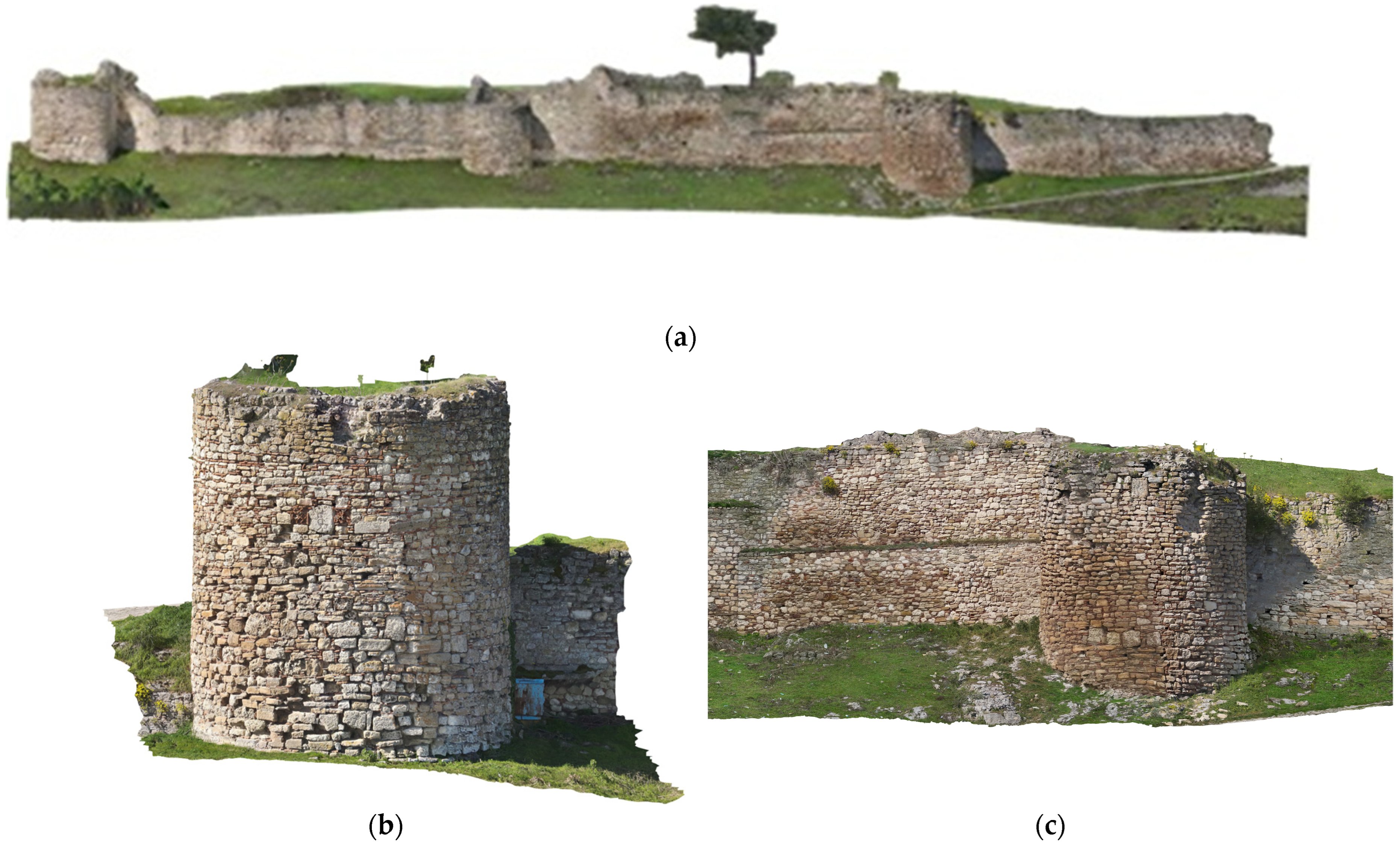
The results of the photogrammetric process were an Orthomosaic οf the entire area which was exported in GGRS87/GreekGrid. DTM, DSM and façades are presented in Figure 8, Figure 9 and Figure 10, representing the visual documentation of the current state of the archaeological site.

3.2. Correlation Between Urban Growth and Cultural Heritage Management and Assessment

The study highlights the relationship between urban development intensity and the degradation of archaeological heritage landscapes, using UAV technology to monitor and manage these changes effectively. The selected archaeological area served as a testbed to assess whether UAVs could deliver high-resolution orthophotos swiftly and reliably, facilitating assessment of the cultural heritage monuments of the area and lead to the ability of fostering urban growth and requalification strategies. The acquired data provided insights into the peculiarities of the research area, highlighting how rapid urbanization can impact land use and the importance of sound urban management practices in mitigating archaeological heritage degradation.
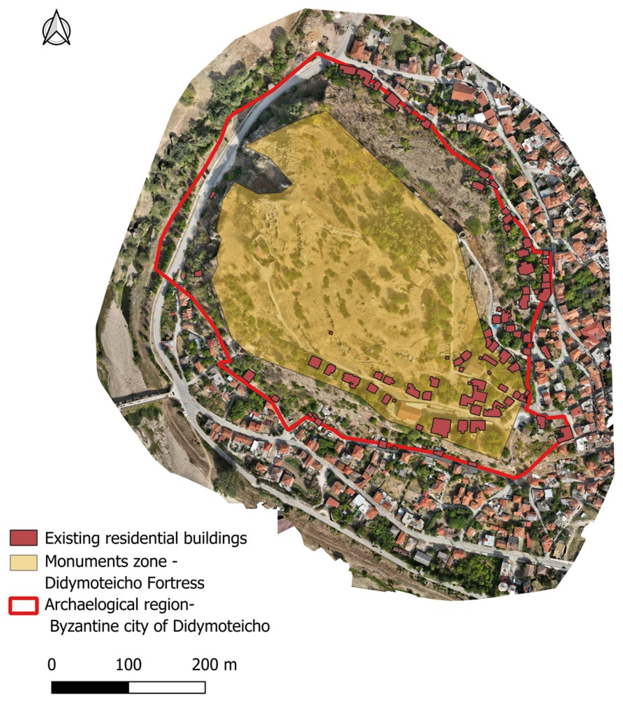
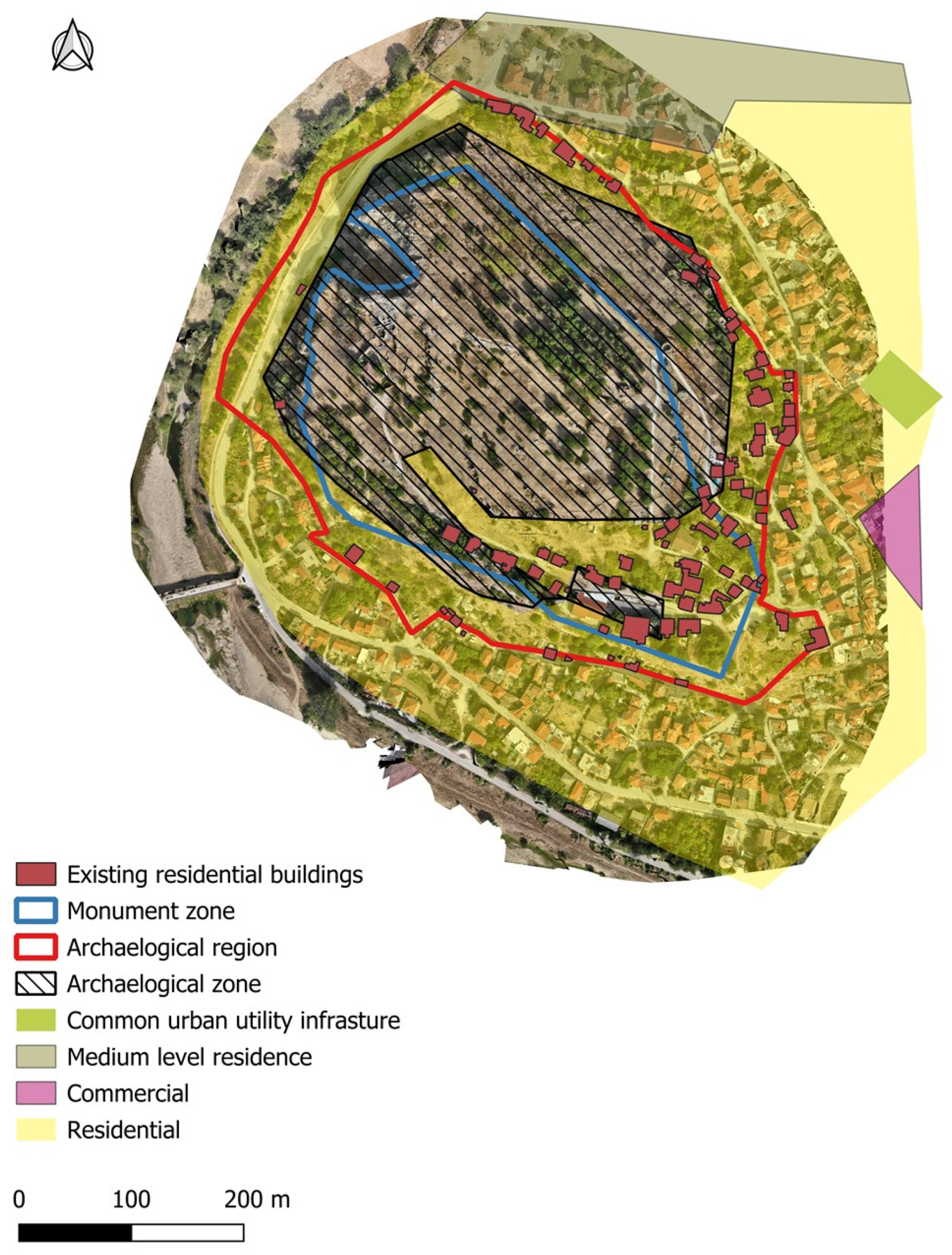
In order to verify the official city planning boundaries and assess compliance, we consulted documentation files from the National Archive of Monuments [38] (Figure 11) and the Urban Regulations Bureau [39] (Figure 12). These records were integrated into a GIS environment, where they were georeferenced and stored within a structured geodatabase. This enabled the precise spatial overlay of current urban structures with the designated protection boundaries. Through geoprocessing operations, specifically, spatial intersection analysis between these official boundary datasets with the building footprints extracted from UAV-derived orthomosaics, we quantified the degree of encroachment into restricted areas. The analysis revealed that urban settlements have expanded into zones that are designated as unsuitable for construction, indicating patterns of uncontrolled growth within this sensitive landscape. Our analysis identified that 91 buildings are located within the characterized archaeological zone of the study area, while 37 are within the monument zone (Figure 11). This reveals how improper urban expansion in these protected zones led to the mismanagement of the archaeological heritage areas, resulting in significant deterioration of both the cultural monuments and their surrounding environments. The rapid and uncontrolled urban growth in the area (Figure 12 and Figure 13) not only encroached upon historically sensitive sites but also exacerbated the degradation of the heritage structures. These findings highlight the urgent need for more precise land management strategies and stronger regulatory frameworks to effectively safeguard these invaluable cultural assets.
The data accumulated from drone imagery proved to be of significant importance for assessing key aspects of urban growth and its impact on the surrounding archaeological heritage. First of all, it allowed for the identification of areas that were densely built outside the legal boundaries of the established city fabric. Furthermore, it highlighted archaeological zones that had suffered degradation due to the vast urban redevelopment in the aforementioned area. Lastly, it uncovered potential urban voids and connections that, although contributing to degradation, could also be leveraged for future urban renewal (Figure 12 and Figure 13).
Data analysis revealed consistent urban voids within the existing fabric, providing potential spaces for sustainable development. These voids could be transformed into new urban spaces, while simultaneously incorporating cultural heritage assets into these future developments. This area presents an opportunity for a thoughtful mixture of urban and cultural spaces, allowing for both the preservation of historical landmarks and the regeneration of the city’s urban landscape in a manner that is both sustainable and respectful of its heritage.
Figure 14 presents field-captured images illustrating the contrasting current conditions of the Byzantine fortress site. The northern section of the fortress remains relatively well-preserved, exhibiting minimal signs of anthropogenic disturbance or encroachment by urban development. This area shows limited intervention, maintaining structural integrity and controlled vegetation cover. In contrast, the southern section displays significant signs of deterioration, characterized by unchecked vegetation growth that contributes to the accelerated degradation of the archaeological fabric. Furthermore, this area has been subject to unregulated urban encroachment, as evidenced by the presence of residential buildings within or adjacent to the fortress boundaries. Such uncontrolled development not only threatens the conservation of the site but also complicates potential preservation and management efforts. These observations underscore spatial heterogeneity in site conservation status, likely reflecting differing land-use pressures and regulatory enforcement across the fortress precinct.

4. Discussion

The UAV employed in this study proved optimal due to its small size, automated flight planning capabilities, low take-off weight, and adaptability to adverse weather conditions, such as high winds and humidity that was made from water drops and due to the clouds. These features allowed for consistent data acquisition in challenging environments, enhancing the reliability of long-term monitoring efforts. The high-quality aerial imagery collected not only aids urban policymakers in understanding dynamic land-use patterns but also provides crucial insights into the spatial relationship between urban expansion and the degradation of heritage sites and surrounding natural landscapes.
To create a scalable and replicable framework for continuous UAV-based monitoring of heritage sites worldwide, the study proposes a comprehensive approach that combines UAV technology with urban management and heritage conservation strategies. This framework involves regular UAV flights to capture high-resolution images and orthophotos, enabling detailed and time-sensitive monitoring of cultural heritage sites and their environments. UAV data can be systematically compared with existing records, such as historical documentation from national archives and datasets from urban planning authorities, to analyze development trends and their effects on protected heritage areas. By identifying zones where urban expansion has intruded upon or damaged archaeological sites, the framework can help prioritize areas in need of immediate intervention. Furthermore, UAV-based analysis can reveal underutilized urban voids that may offer opportunities for sustainable development, while simultaneously ensuring the protection of historical landmarks.
While previous studies [40,41], have demonstrated the utility of UAV-based photogrammetry in cultural heritage documentation and change detection, they often focused on static assessments without integrating real-time urban development indicators. This research contributes to the field by offering a more dynamic, application-oriented approach that bridges high-resolution UAV imagery with urban planning frameworks. An important strength of our approach lies in the fact that UAV-derived products are inherently georeferenced, that enables overlays and regulatory comparisons to be performed automatically within GIS environments. This spatial alignment allowed the integration of protection zones, derived from the National Archive of Monuments, with the UAV-derived orthophotos and 3D models. It also enabled the combination of these products with urban planning layers. Importantly, no additional georeferencing or manual adjustments were required. Such automation not only reduced the time and expertise needed for data processing but also helped minimizing the risk of human error, thus ensuring greater reliability in the results.
Building on our case study, structured and step-by-step key actions are proposed for safeguarding vulnerable archaeological sites in peripheral areas of Greece such as Didymoteicho:
1.
Digital documentation of the monument: Produce high-resolution UAV-based mapping and 3D modelling of the archaeological site under study and its immediate environment. This provides a precise and up-to-date record of the site’s condition and spatial context.
2.
Assessment of current condition: Analysis of the structural state of the monument and surrounding landscape, identifying signs of deterioration, structural vulnerabilities, and external pressures such as vegetation overgrowth or nearby construction.
3.
Spatial analysis and regulatory comparison: Overlaying the generated spatial data with the official zones defined by the Archaeological Cadastre (e.g., monument zone and archaeological protection zone) to assess compliance and detect unauthorized developments. A key advantage of this approach is that all UAV-derived products are georeferenced, enabling overlays and regulatory comparisons to be performed automatically within GIS. This automation reduces the need for manual interpretation, minimizes errors, and accelerates the detection of encroachments or unauthorized developments. As a result, the framework becomes not only more efficient and accurate but also highly transferable to other heritage sites and urban contexts.
4.
Identification of critical areas: Highlight areas where modern settlements or illegal structures intersect with protected zones, particularly within the monument boundaries, prioritizing these areas for intervention.
5.
Engagement with local authorities: Present findings to municipal and regional authorities, providing visual and spatial evidence to support enforcement of heritage regulations and the integration of heritage into local planning processes.
6.
Awareness and community involvement: Develop outreach initiatives to raise public awareness of the monument’s historical significance, the threats it faces, and the importance of its preservation. This could include educational materials, exhibitions, or community workshops.
7.
Establishment of a monitoring system: Propose a long-term digital monitoring framework using periodic UAV surveys and GIS-based change detection to track alterations in land use, new constructions, or environmental degradation around the site.
By following this sequence of actions, stakeholders can move from documentation to informed decision-making, ensuring both the protection of cultural heritage and the sustainable development of the surrounding urban fabric. What distinguishes this study is its implementation of a systematic and repeatable methodology that combines high-resolution UAV-based mapping and visual interpretation to document and assess the current condition of a threatened heritage site. While this work primarily focuses on visual analysis, it establishes a foundational dataset that can support more advanced spatial assessments in the future—such as examining proximity to protected zones, settlement density, and encroachment patterns. By proposing how such methods could be further developed and applied, the study contributes a practical, scalable framework for supporting decision-making processes. Additionally, even though this study concentrates on peripheral sites in Greece, the UAV-based monitoring framework it proposes, can be easily applied to small- and medium-sized cities around the world. The approach—integrating automated UAV flights, high-resolution imagery, 3D modeling, GIS analysis, and linkage with local planning datasets—is inherently scalable and does not depend on location-specific infrastructure. Cities facing similar challenges, such as rapid urban growth, threats to heritage sites, or limited resources for on-site monitoring, can adopt this methodology to systematically document and evaluate vulnerable cultural assets. By offering a repeatable workflow for digital documentation, condition assessment, and long-term monitoring, the framework facilitates informed decision-making and proactive heritage management across diverse urban settings. Ultimately, this research contributes with a decision-support mechanism that enables planners and heritage professionals to proactively manage urban growth while safeguarding irreplaceable cultural assets.

5. Conclusions

The study highlights the effectiveness of UAV-based 3D mapping in assessing the impact of urbanization on archaeological heritage. UAV technology allowed for the swift collection of high-resolution orthophotos, enabling a comprehensive evaluation of cultural heritage sites within the selected archaeological area. The data established a clear connection between the level of urban development and the degradation of surrounding archaeological landscapes, emphasizing the need for efficient urban management practices. By comparing UAV imagery with records from the National Archive of Monuments and the Urban Regulations Bureau, the study identified areas where urban growth exceeded construction limits, leading to the mismanagement and decay of protected heritage sites. The UAV data provided crucial insights into overdeveloped areas, particularly where dense construction encroached upon cultural heritage zones. Additionally, it revealed potential urban voids that could be utilized for sustainable development, promoting both heritage preservation and urban renewal. This study underscores the necessity for precise land management and stricter regulatory measures to safeguard cultural heritage from the negative impacts of unchecked urban growth.
Future research in UAV-based monitoring of heritage sites could focus on incorporating artificial intelligence (AI) for the automated detection of degradation. AI algorithms could process UAV-collected images to detect early signs of deterioration or structural damage, improving both the speed and accuracy of assessments [42,43]. Moreover, integrating UAV data with other remote sensing technologies, such as satellite imagery, could offer a more holistic view of how urbanization affects heritage sites [44,45,46]. This multi-sensor approach would enable the detection of both surface and subsurface damage, allowing for better monitoring of areas that are challenging to assess with UAVs alone. Further exploration of real-time data processing and cloud-based platforms could also enhance decision-making for heritage conservation and urban development, enabling more adaptable and efficient management strategies. These advancements would significantly enhance the effectiveness of UAV-based monitoring and promote sustainable urban growth while protecting cultural heritage.
Additional future research could benefit from integrating the UAV-derived 3D models with viewshed analysis. Aspects such as the potential visual impacts of modern settlements on archaeological sites, commonly assessed through GIS-based viewshed analysis, can provide valuable insights into visual disturbances and the broader landscape context of heritage sites. However, three-dimensional analyses of building or monument heights were beyond the scope of the present work, since no stereo-based evaluation was performed. Drawing from the study’s findings, several recommendations can be made for key stakeholders in heritage conservation and urban development. For archaeologists and heritage managers, it is advised to incorporate UAV technology for regular monitoring of cultural heritage sites. UAVs can capture high-resolution imagery, enabling the early identification of deterioration and facilitating timely preservation efforts. Urban planners should create guidelines that emphasize the safeguarding of heritage sites within urban zones, focusing on zoning regulations and construction restrictions in culturally significant areas to prevent encroachment or damage from urban expansion. Policymakers should integrate UAV data into urban planning processes, refining policies to ensure that development near heritage sites is carefully managed. By leveraging UAV data to track land-use changes and urban growth, policymakers can assess the risks to cultural heritage more effectively and enforce stronger protections, thus fostering a balance between heritage preservation and sustainable urban development.
In conclusion, while UAV-based mapping and GIS techniques are well established in heritage documentation, this study advances their application by integrating them into a systematic, scalable, and replicable framework designed for continuous monitoring of vulnerable archaeological sites, with Didymoteicho serving as a case study. Our approach links the analysis of urban development patterns with the assessment of archaeological landscape degradation, offering a quantitative and visual tool to identify zones at risk, prioritize interventions, and support regulatory enforcement. With the applied methodology a practical workflow is proposed for spatio-temporal monitoring and the potential of UAV-based geospatial analysis is highlighted, to inform evidence-based urban management and cultural heritage protection.

Author Contributions

Conceptualization, E.S., A.S. (Alexandros Skondras) and Z.E.T.; methodology, A.S. (Alexandros Skondras) and E.S.; software, Z.E.T.; validation, Z.E.T., I.S., A.S. (Aikaterini Stamou) and I.T.; data curation, Z.E.T.; writing—original draft preparation, A.S. (Alexandros Skondras) and I.S.; writing—review and editing, A.S. (Alexandros Skondras), Z.E.T., A.S. (Aikaterini Stamou), E.S., I.T. and I.S.; visualization, A.S. (Alexandros Skondras), Z.E.T. and A.S. (Aikaterini Stamou); supervision E.S. All authors have read and agreed to the published version of the manuscript.

Funding

This research received no external funding.

Data Availability Statement

The data presented in this study are available on request from the corresponding author as they are part of ongoing PhD research.

Conflicts of Interest

The authors declare no conflicts of interest.

References

  1. UNESCO. Culture: Urban Future; Global Report on Culture for Sustainable Urban Development; Summary; United Nations Educational, Scientific and Cultural Organization: Paris, France, 2016. [Google Scholar]
  2. Tabrizi, S.K.; Abdelmonem, M.G. Contemporary construction in historical sites: The missing factors. Front. Archit. Res. 2024, 13, 487–504. [Google Scholar] [CrossRef]
  3. Jigyasu, R. Reducing Disaster Risks to Urban Cultural Heritage: Global Challenges and Opportunities. J. Herit. Manag. 2016, 1, 59–67. [Google Scholar] [CrossRef]
  4. UNESCO. Recommendation on the Historic Urban Landscape. Available online: https://whc.unesco.org/en/hul/ (accessed on 9 April 2025).
  5. Alessandri, C. (Ed.) The Restoration of the Nativity Church in Bethlehem, 1st ed.; CRC Press: Boca Raton, FL, USA, 2020. [Google Scholar] [CrossRef]
  6. Regnauld, N.; Mackaness, W.A.; Hart, G. Automated relief representation for visualisation of archaeological monuments and other anthropogenic forms. Comput. Environ. Urban Syst. 2002, 26, 219–239. [Google Scholar] [CrossRef]
  7. Sestras, P.; Badea, G.; Badea, A.C.; Salagean, T.; Roșca, S.; Kader, S.; Remondino, F. Land surveying with UAV photogrammetry and LiDAR for optimal building planning. Autom. Constr. 2025, 173, 106092. [Google Scholar] [CrossRef]
  8. Fekade, W. Deficits of formal urban land management and informal responses under rapid urban growth, an international perspective. Habitat Int. 2000, 24, 127–150. [Google Scholar] [CrossRef]
  9. Bashandy, S.Y.H.; Abd Elaziz, N. Urban Heritage Life Monitoring: As a Proactive Tool for Sustainable Heritage Areas. J. Eng. Appl. Sci. 2020, 67, 2033–2052. [Google Scholar]
  10. Zan, L.; Baraldi, S.B.; Gordon, C. Cultural Heritage Between Centralisation and Decentralisation: Insights from the Italian context. Int. J. Cult. Policy 2007, 13, 49–70. [Google Scholar] [CrossRef]
  11. Soleymani, A.; Jahangir, H.; Nehdi, M.L. Damage detection and monitoring in heritage masonry structures: Systematic review. Constr. Build. Mater. 2023, 397, 132402. [Google Scholar] [CrossRef]
  12. Bandarin, F.; Van Oers, R. The Historic Urban Landscape: Managing Heritage in an Urban Century; Wiley: Hoboken, NJ, USA, 2012. [Google Scholar] [CrossRef]
  13. Nikolakopoulos, K.G.; Soura, K.; Koukouvelas, I.K.; Argyropoulos, N.G. UAV vs classical aerial photogrammetry for archaeological studies. J. Archaeol. Sci. Rep. 2017, 14, 758–773. [Google Scholar] [CrossRef]
  14. Treccani, D.; Adami, A.; Fregonese, L. Drones and Real-Time Kinematic Base Station Integration for Documenting Inaccessible Ruins: A Case Study Approach. Drones 2024, 8, 268. [Google Scholar] [CrossRef]
  15. Martínez-Espejo Zaragoza, I.; Caroti, G.; Piemonte, A.; Riedel, B.; Tengen, D.; Niemeier, W. Structure from motion (SfM) processing of UAV images and combination with terrestrial laser scanning, applied for a 3D-documentation in a hazardous situation. Geomat. Nat. Hazards Risk 2017, 8, 1492–1504. [Google Scholar] [CrossRef]
  16. Jordan, S.; Moore, J.; Hovet, S.; Box, J.; Perry, J.; Kirsche, K.; Lewis, D.; Tse, Z.T.H. State-of-the-art technologies for UAV inspections. IET Radar Sonar Navig 2018, 12, 151–164. [Google Scholar] [CrossRef]
  17. Woo, H.-J.; Seo, D.-M.; Kim, M.-S.; Park, M.-S.; Hong, W.-H.; Baek, S.-C. Localization of Cracks in Concrete Structures Using an Unmanned Aerial Vehicle. Sensors 2022, 22, 6711. [Google Scholar] [CrossRef] [PubMed]
  18. Vavulin, M.V.; Chugunov, K.V.; Zaitceva, O.V.; Vodyasov, E.V.; Pushkarev, A.A. UAV-based photogrammetry: Assessing the application potential and effectiveness for archaeological monitoring and surveying in the research on the ‘valley of the kings’ (Tuva, Russia). Digit. Appl. Archaeol. Cult. Herit. 2021, 20, e00172. [Google Scholar] [CrossRef]
  19. Puerto, A.; Castañeda, K.; Sánchez, O.; Peña, C.A.; Gutiérrez, L.; Sáenz, P. Building information modeling and complementary technologies in heritage buildings: A bibliometric analysis. Results Eng. 2024, 22, 102192. [Google Scholar] [CrossRef]
  20. Suresh, R.; Nurul, R. Evaluating the Impact of Digital Mapping and 3D Imaging Technologies on the Restoration of Historical Sites in Southeast Asia. Stud. Art Archit. 2024, 3, 1–7. [Google Scholar] [CrossRef]
  21. Azrour, M.; Baba, K.; Batan, A.; El Rhaffari, Y.; Fratini, F.; Gonzales, F.; Haddad, M.; Ibnoussina, M.; Nounah, A.; Pittaluga, D.; et al. Mediterranean Architectural Heritage—RIPAM10. Mater. Res. Proc. 2024, 40, 33–40. [Google Scholar] [CrossRef]
  22. Diaz Riveros, C.A.; Cuesta Beleño, A.; Frediani, J.; Rodriguez Tarducci, R.; Cortizo, D. Comparative Analysis of Spatial and Environmental Data in Informal Settlements, from Point Clouds and RPAS Images. In International Conference on Applied Informatics; Florez, H., Leon, M., Eds.; Communications in Computer and Information Science; Springer: Cham, Switzerland, 2023; Volume 1874. [Google Scholar] [CrossRef]
  23. Hu, D.; Minner, J. UAVs and 3D City Modeling to Aid Urban Planning and Historic Preservation: A Systematic Review. Remote Sens. 2023, 15, 5507. [Google Scholar] [CrossRef]
  24. Oosterbroek, B.; de Kraker, J.; Huynen, M.; Martens, P.; Verhoeven, K. Assessment of green space benefits and burdens for urban health with spatial modeling. Urban For. Urban Green. 2023, 86, 128023. [Google Scholar] [CrossRef]
  25. UNESCO. Urban Heritage for Resilience: Consolidated Results of the Implementation of the 2011 Recommendation on the Historic Urban Landscape; 3rd Member States Consultation, United Nations Educational, Scientific and Cultural Organization; UNESCO: Paris, France, 2023. [Google Scholar] [CrossRef]
  26. Zhou, L.; Yin, H.; Zhao, H.; Wei, J.; Hu, D.; Leung, V. A Comprehensive Survey of Artificial Intelligence Applications in UAV-Enabled Wireless Networks. Digit. Commun. Netw. 2024, in press. [Google Scholar] [CrossRef]
  27. Pal, O.K.; Shovon, M.S.H.; Mridha, M.F.; Shin, J. In-depth review of AI-enabled unmanned aerial vehicles: Trends, vision, and challenges. Discov. Artif. Intell. 2024, 4, 97. [Google Scholar] [CrossRef]
  28. Lyu, C.; Lin, S.; Lynch, A.; Zou, Y.; Liarokapis, M. UAV-based deep learning applications for automated inspection of civil infrastructure. Autom. Constr. 2025, 177, 106285. [Google Scholar] [CrossRef]
  29. Shi, Y.; Wang, W.; Zhang, J.; Li, D.; Liu, F.; Li, W. UAV remote sensing and deep learning for assessing and optimizing architectural texture in traditional villages. npj Herit. Sci. 2025, 13, 325. [Google Scholar] [CrossRef]
  30. Guzman, P.; Pereira Roders, A. Bridging the gap between urban development and cultural heritage protection. In IAIA14 Conference Proceedings; IAIA14: Viña del Mar, Chile, 2014. [Google Scholar] [CrossRef]
  31. Labib, N.S.; Brust, M.R.; Danoy, G.; Bouvry, P. The Rise of Drones in Internet of Things: A Survey on the Evolution, Prospects and Challenges of Unmanned Aerial Vehicles. IEEE Access 2021, 9, 115466–115487. [Google Scholar] [CrossRef]
  32. UNESCO. The Operational Guidelines for the Implementation of the World Heritage Convention. Available online: https://whc.unesco.org/en/guidelines/ (accessed on 9 April 2025).
  33. Ginzarly, M.; Houbart, C.; Teller, J. The Historic Urban Landscape approach to urban management: A systematic review. Int. J. Herit. Stud. 2018, 25, 1–21. [Google Scholar] [CrossRef]
  34. De Fino, M.; Galantucci, R.A.; Fatiguso, F. Condition Assessment of Heritage Buildings via Photogrammetry: A Scoping Review from the Perspective of Decision Makers. Heritage 2023, 6, 7031–7066. [Google Scholar] [CrossRef]
  35. Buragohain, D.; Meng, Y.; Deng, C.; Li, Q.; Chaudhary, S. Digitalizing cultural heritage through metaverse applications: Challenges, opportunities, and strategies. Herit. Sci. 2024, 12, 295. [Google Scholar] [CrossRef]
  36. Zavagno, L.; Bakirtzis, N. The Routledge Handbook of the Byzantine City. In The Routledge Handbook of the Byzantine City From Justinian to Mehmet II (Ca. 500–Ca.1500); Routledge Publishing: Abingdon-on-Thames, Oxfordshire, UK, 2024; ISBN 9780367196790. [Google Scholar]
  37. Kastropolites Didymoteixou. Available online: https://kastropolites.com/didym-otoman-arsiv-history/ (accessed on 1 September 2025).
  38. National Archive of Monuments, Greece. Available online: https://www.arxaiologikoktimatologio.gov.gr/en (accessed on 20 November 2024).
  39. e-Poleodomia, Urban Regulations Bureau, Greece. Available online: http://gis.epoleodomia.gov.gr/v11/index.html#/25.0814/40.6279/9 (accessed on 20 November 2024).
  40. Tapete, D.; Cigna, F. Trends and perspectives of space-borne SAR remote sensing for archaeological landscape and cultural heritage applications. J. Archaeol. Sci. Rep. 2017, 14, 716–726. [Google Scholar] [CrossRef]
  41. Remondino, F.; Spera, M.G.; Nocerino, E.; Menna, F.; Nex, F. State of the art in high density image matching. Photogram Rec. 2014, 29, 144–166. [Google Scholar] [CrossRef]
  42. Ngeljaratan, L.; Bas, E.E.; Moustafa, M.A. Unmanned Aerial Vehicle-Based Structural Health Monitoring and Computer Vision-Aided Procedure for Seismic Safety Measures of Linear Infrastructures. Sensors 2024, 24, 1450. [Google Scholar] [CrossRef]
  43. Plevris, V.; Papazafeiropoulos, G. AI in Structural Health Monitoring for Infrastructure Maintenance and Safety. Infrastructures 2024, 9, 225. [Google Scholar] [CrossRef]
  44. Butt, N.u.S.Z.; Wang, X.; Luo, L.; Ul Hussan, H. Evaluating the Impact of Urban Encroachment and Land Cover Changes on World Cultural Heritage Site Taxila: A Spatio-Temporal Analysis from 1990 to 2024. Sustainability 2025, 17, 1059. [Google Scholar] [CrossRef]
  45. Papakonstantinou, A.; Kavroudakis, D.; Kourtzellis, Y.; Chtenellis, M.; Kopsachilis, V.; Topouzelis, K.; Vaitis, M. Mapping Cultural Heritage in Coastal Areas with UAS: The Case Study of Lesvos Island. Heritage 2019, 2, 1404–1422. [Google Scholar] [CrossRef]
  46. Zachos, A.; Anagnostopoulos, C.N. Using TLS, UAV, and MR Methodologies for 3D Modelling and Historical Recreation of Religious Heritage Monuments. ACM J. Comput. Cult. Herit. 2024, 17, 1–23. [Google Scholar] [CrossRef]
Figure 1. The study area of Didymoteicho, located in Northeastern Greece, featuring the Byzantine fortress, one of the most significant castles of Thrace and a major Byzantine monument of Northern Greece (retrieved Google Earth image).
Drones 09 00669 g001
Figure 2. (a) Part of the Byzantine fortress in Didymoteicho (aerial view). (bd) Close-ups of areas where residential development and uncontrolled natural overgrowth encroach upon the fortress walls.
Drones 09 00669 g002
Figure 3. (a) The grid-based flight plan over the study area. Image acquisition positions, shown as red points, form a dense and uniform network covering the entire site. (b) Example of image acquisition positions of manual flights, capturing certain sections of the monument.
Drones 09 00669 g003
Figure 4. Examples of blurred images captured on different dates: (a) October 2023 (b) December 2023.
Drones 09 00669 g004
Figure 5. A total of 12 GCPs, measured with differential GNSS, were evenly distributed throughout the study area, and used for the accuracy assessment procedures.
Drones 09 00669 g005
Figure 6. Archival aerial images of the Didymoteicho area (a) from 2007 to 2009, and (b) from approximately 1945–1960, retrieved from the Hellenic Cadaster database. The images show the early urban settlement patterns within and around the Byzantine fortress, characterized by low-density, village-style housing with limited morphological changes in urban structure since the mid-20th century, highlighting the persistence of historical settlement patterns.
Drones 09 00669 g006
Figure 7. (a) Conceptual workflow of the methodology applied, (b) UAV based photogrammetric workflow for 3D reconstruction of the monument.
Drones 09 00669 g007
Figure 8. UAV-derived orthomosaic covering the entire region under study.
Drones 09 00669 g008
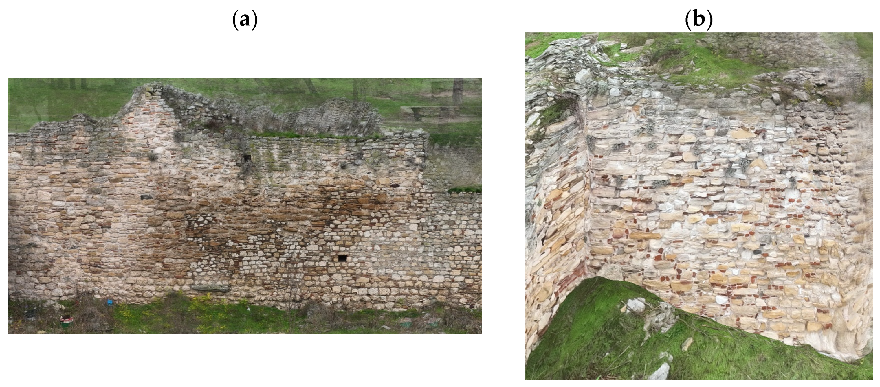
Figure 9. Fortress façades generated from mosaicked images with five-fold redundancy per ground pixel to ensure high spatial detail. (a) Façade of the north-east side of the wall where sections of the structure have undergone restoration. (b,c) close-ups of the wall, highlighting structural details and textures captured through the high-overlap image mosaics.
Drones 09 00669 g009
Figure 10. DTM and DSM of the castle area, clearly illustrating the prominent hill on which the fortress is situated. The models vividly depict the significant inclination and varying elevations of the terrain, highlighting the natural topographic features that have historically influenced the site’s strategic positioning.
Drones 09 00669 g010
Figure 11. Comparison between the UAV-captured imagery and the designated archaeological protection zone in Didymoteicho shows that multiple structures (marked in red) are located within the restricted area, where building activity should be forbitten due to the presence of significant archaeological heritage.
Drones 09 00669 g011
Figure 12. A detailed overlay of the produced high-resolution drone imagery with the officially designated zones of construction limitation, as defined by both urban planning regulations and the Archaeological Cadastre. In addition to delineating these regulatory boundaries, the figure also maps and highlights the identified residential settlements that currently exist within the protected archaeological region.
Drones 09 00669 g012
Figure 13. Overlay of identified settlements and structures on the drone-derived orthoimage of Didymoteicho, showing their spatial relationship to officially designated protection zones. The archaeological zones, retrieved from the Archaeological Cadastre of Greece, include the broader archaeological protection area (in red) and the monument zone specifically encompassing the fortress (in blue). The figure highlights modern buildings located both within the archaeological zone and, more critically, inside the monument zone itself, illustrating the extent of encroachment and the pressures on heritage management in the area.
Drones 09 00669 g013
Figure 14. Field-captured images illustrating the contrasting current conditions of the Byzantine fortress site (a) Northern section, (b) Southern section.
Drones 09 00669 g014
Table 1. Characteristics of the equipment used.
Type
UAVDJI Mavic 3 Enterprise
F-stopf/2.8
Camera model M3M_12.3_5280 × 3956 (RGB)
Flight height92.4 m above ground level—autonomous
16.5 m above ground level—manual north part
18.9 m above ground level—manual south part
Table 2. Geolocation Variances.
Geolocation Error X [%]Geolocation Error Y [%]Geolocation Error Z [%]
Mean Error (m)0.0000190.0001160.007624
St. Deviation σ (m)0.0076240.0089790.074787
RMS Error (m)0.0076240.0089800.074787
Table 3. Accuracy assessment at 12 Ground Control Points (GCPs).
XYZ
Mean Error (m)0.0350.0300.055
St. Deviation σ (m)0.0320.0280.047
RMSE (m)0.0470.0410.072
Table 4. Bundle block adjustment results.
Type
Number of 2D Key point Observations for Bundle Block Adjustment32,709,016
Number of 3D Points for Bundle Block Adjustment10,077,149
Mean Reprojection Error [pixels]0.187
Overlap5 images per pixel/80% forward and 70% side overlap
Disclaimer/Publisher’s Note: The statements, opinions and data contained in all publications are solely those of the individual author(s) and contributor(s) and not of MDPI and/or the editor(s). MDPI and/or the editor(s) disclaim responsibility for any injury to people or property resulting from any ideas, methods, instructions or products referred to in the content.