Article

Digital Construction Preservation Techniques of Endangered Heritage Architecture: A Detailed Reconstruction Process of the Dong Ethnicity Drum Tower (China)

1
Department of College of Science, Kaili University, Kaili 556011, China
2
Institute of Automation, Chinese Academy of Sciences, Beijing 100190, China
3
Qiandongnan Prefecture Architectural Design Institute Limited Liability Company, Kaili 556011, China
*
Author to whom correspondence should be addressed.
Drones 2024, 8(9), 502; https://doi.org/10.3390/drones8090502
Submission received: 10 August 2024 / Revised: 13 September 2024 / Accepted: 16 September 2024 / Published: 19 September 2024

Abstract

:
This study suggests a pioneering conservation framework that significantly enhances the preservation, renovation, and restoration of heritage architecture through the integration of contemporary digital technologies. Focusing on the endangered drum towers of the Dong ethnic group in Southwestern China, the research employs a meticulous data collection process that combines manual measurements with precise 2D imaging and oblique unmanned aerial vehicle (UAV) photography, enabling comprehensive documentation of tower interiors and exteriors. Collaboration with local experts in drum tower construction not only enriches the data gathered but also provides profound insights into the architectural nuances of these structures. An accurate building information modeling (BIM) simulation illuminates the internal engineering details, deepening the understanding of their complex design. Furthermore, UAV-obtained point cloud data facilitate a 3D reconstruction of the tower’s exterior. This innovative approach to heritage preservation not only advances the documentation and comprehension of heritage structures but also presents a scalable, replicable model for cultural conservation globally, paving the way for future research in the field.

1. Introduction

Heritage architecture plays a vital role in shaping cultural identity and promoting social development [1]. These cultural and heritage resources, in addition to providing cultural, spiritual, and aesthetic enrichment, also contribute substantial economic benefits [2]. However, heritage sites worldwide face various threats, including environmental degradation [3]. Notably, even renowned structures like the Taj Mahal in India and the Campanile in Italy have suffered from natural forces [4].
The Southwest China Dong ethnic drum towers, as shown in Figure 1, are facing the same broad threats as heritage structures elsewhere. The Dong drum tower is a prominent traditional building in Dong culture, primarily used for gatherings and discussions of important matters among villagers. As a landmark of Dong villages, the Drum tower showcases the Dong people’s exceptional wood construction skills through its distinctive design. The tower structure shares many similarities with traditional Chinese pagodas, particularly in its layered form and multifunctional design. This structural feature not only contributes to the Drum tower’s unique visual aesthetics but also enhances its overall stability.
The Dong ethnic community lives predominantly in Southwestern China, across the provinces of Guizhou, Hunan, and Guangxi [5]. This study places particular emphasis on the southern Dong communities, which evolved later than their northern counterparts and have managed to maintain their native and traditional culture to a greater degree. This region is recognized as the epicenter of Dong drum tower culture. The drum tower holds deep cultural and spiritual significance for the Dong community and serves as an iconic symbol within Dong villages [6], serving a multifaceted role through various functions [7,8], including the following:
  • Hosting communal ceremonies and facilitating discussions on crucial village matters.
  • Resolving disputes and mediating conflicts among villagers.
  • Sounding alarm drums to warn of fires, floods, and potential threats.
  • Acting as a venue for the performance of traditional Dong ethnic songs and as a social gathering place for young men and women to mingle and sing.
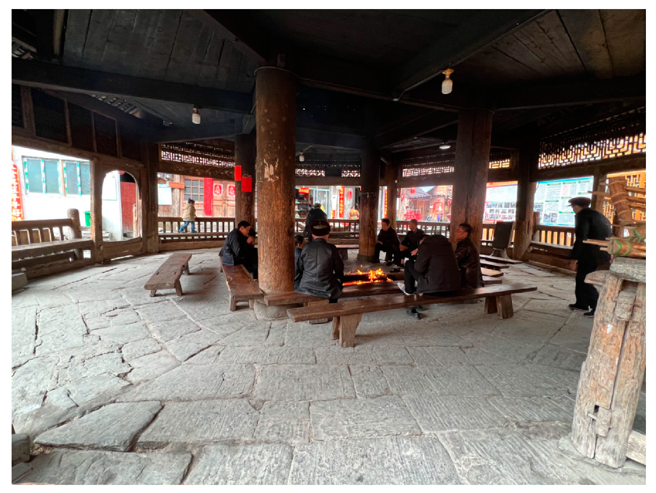
  • Providing warmth through fire heating during festivities (see Figure 2).
  • Hosting external guests and serving as a platform for announcing critical decisions and announcements.
In addition to these challenges is the situation of the Dong people who, despite having their own language, lack a written script [5]. Once the oral transmission of construction techniques becomes inaccessible, future generations face significant challenges in restoring and reconstructing drum towers [9], posing a huge obstacle to their preservation and protection. The construction craftsmanship of the tower section of the Congjiang drum tower, for instance, is evidently less refined compared to the earlier Zengchong drum tower, suggesting that certain construction techniques have been partially lost over time [10]. Currently, there is a notable shortage of expertise in key aspects of traditional drum tower construction, including timber treatment, decorative carving techniques, and unique timber preservation methods. This includes the solid mortise and tenon joints that are fundamental to their structural design. The loss of this knowledge is largely due to modernization, which has led to the replacement of traditional wooden buildings with reinforced concrete structures. Additionally, there are no architectural drawings or written records documenting Drum Tower construction techniques, as these methods were historically passed down orally. The declining interest among younger generations in preserving traditional culture, coupled with the aging of skilled craftsmen, has further accelerated the loss of these invaluable construction techniques.
Consequently, investigating innovative protection technologies and methods for heritage buildings has become a central focus in cultural heritage preservation. Prior research emphasizes the importance of risk assessment frameworks in conservation planning [11,12]. For instance, BIM technology can be employed to create detailed simulations of the drum tower, providing a scientific basis for structural reinforcement. Additionally, 3D modeling facilitates precise documentation of the building’s materials and structure, supporting ongoing monitoring and timely restoration efforts. These technologies also allow for the simulation of various restoration strategies, enabling the evaluation of their long-term impacts and ensuring a balance between cultural preservation and functional use. Moreover, virtual representations can enhance public engagement in conservation efforts, fostering broader participation and awareness. Such frameworks are crucial for identifying and mitigating potential hazards to heritage sites. Maintaining visual integrity is also important [13], as shown in the use of eye tracking technology to investigate the impact of contemporary architecture on the perception of heritage sites. This approach has provided insightful data on how modern and historical architectures coexist within a single visual landscape. In addition, there has been a concentrated effort to incorporate cultural values into adaptive reuse [14], recognizing the importance of cultural heritage as a living part of our communities. This approach ensures that the transformation of heritage sites for new purposes respects and retains their cultural significance. Similarly, the integration of protection strategies with effective information management has been suggested [15]. This holistic approach combines physical conservation measures with digital tools for data management, ensuring the comprehensive safeguarding of heritage assets. Moreover, the deployment of affordable technology has facilitated more accessible heritage monitoring [16]. This democratization of technology enables a wider range of stakeholders, including local communities and small-scale organizations, to actively participate in heritage conservation. Dong drum towers have traditionally had their construction techniques passed down orally.
Although the adoption of modern technology in preserving cultural heritage buildings is a global trend [17], there is a lack of research focused on the integration of modern techniques with traditional construction methods and external preservation for reconstruction. Additionally, there is limited literature on this topic (viz. reconstructing minority heritage architecture) from diverse global communities. Notably, the conservation of ethnic heritage buildings in China, a nation rich in ethnic minorities, remains underrepresented in international literature.
To address this gap, this study suggests a pioneering conservation framework specifically designed to safeguard endangered heritage architecture via a case study on the preservation of Dong drum towers, which focuses on the following research objectives:
  • Introduction to drum towers and construction techniques: Through on-site inquiries and in-depth interviews, our study endeavors to reveal the cultural significance of drum towers while closely studying their construction and design process.
  • Data collection for drum towers: We compile data derived from four emblematic drum towers employing manual measurements, 2D imaging techniques [18], and unmanned aerial vehicle (UAV) oblique photography [19].
  • Reconstruction of internal construction engineering structures: We use building information modeling (BIM) tools to record and preserve the construction techniques of the drum towers and reconstruct the complex internal construction engineering structure through case simulations [20].
  • 3D reconstruction of drum tower exteriors: We use point cloud data modeling combined with a 2D image model [21] to achieve 3D reconstructions of the drum towers’ external forms. To test the feasibility of this approach, we conducted a practical demonstration using four drum towers as illustrative examples.

2. Related Works

The integration of traditional preservation methods with advanced technological solutions represents a significant advancement in the field of heritage conservation [22,23]. Leading this transformation is the application of sophisticated 3D information systems, such as Agata software, which facilitate comprehensive documentation of heritage sites [18,19]. These systems have been essential in assessing heritage significance in sustainable refurbishment projects and mitigating the impacts of globalization on cultural heritage [1].
In the realm of heritage preservation, a variety of innovative technologies have been utilized. These include photogrammetry [21], oblique unmanned aerial vehicle (UAV) photography [24,25,26], terrestrial laser scanning, and machine learning techniques [27]. Among these, heritage building information modeling (HBIM) has emerged as a fundamental tool [28,29]. HBIM enables the creation of highly accurate digital replicas of heritage buildings, providing deep insights into their structural and historical complexities. Additionally, the incorporation of big data methodologies and virtual reality further enhances the understanding and preservation of these sites through immersive and comprehensive visualizations [30].
Several studies emphasize the dynamic nature of heritage conservation, highlighting the role of digital technologies, particularly HBIM and UAVs, in enhancing the understanding and preservation of heritage sites. HBIM, with its detailed modeling capabilities, allows for the meticulous documentation of architectural elements and construction techniques. Conversely, UAV photography offers a unique perspective for capturing detailed imagery of heritage structures, especially in inaccessible areas.
However, a significant challenge remains in the universal application of these methods across different types of heritage sites. This challenge underscores the need for customized digital protection strategies that address the specific requirements and contexts of individual heritage sites. Such tailored approaches are crucial to ensuring that the unique characteristics and values of each site are precisely preserved and enhanced.

3. Brief Introduction of Drum Tower Construction Techniques

The architectural form of Dong drum towers combines features of both towers and pavilions, exhibiting intricate and varied characteristics. Distinct from conventional Chinese tower structures, the Dong drum tower displays a range of shapes, such as quadrangular, hexagonal, and octagonal designs [14].
Notably, drum tower construction does not adhere to standardized drawings or blueprints. Builders instead rely on a zhanggan (measuring rod) and moxian (plumb line) to establish numerical measurements as reference points. The entire drum tower is crafted exclusively from wood, showcasing a pure wooden framework. The structure depends primarily on wooden columns interconnected through mortise and tenon joinery. These columns are joined in a crisscross pattern, utilizing the principle of leverage, and are layered to provide support without the need for a single nail or rivet [31].
We will take the octagonal drum tower as a case study. By conducting on-site measurements and interviews with drum tower builders, we will deconstruct the primary framework construction process. Our focus will primarily be on the tower’s constituent components, including the columns, brackets, rafters, and beams that form the tower’s fundamental structural units. The reconstruction process of a Dong drum tower is briefly described as follows:
  • Site selection and material procurement: The drum tower’s location is selected in consultation with geomancers to address feng shui considerations. Construction uses primarily local materials, including pine wood, locally crafted ceramics, and tiles.
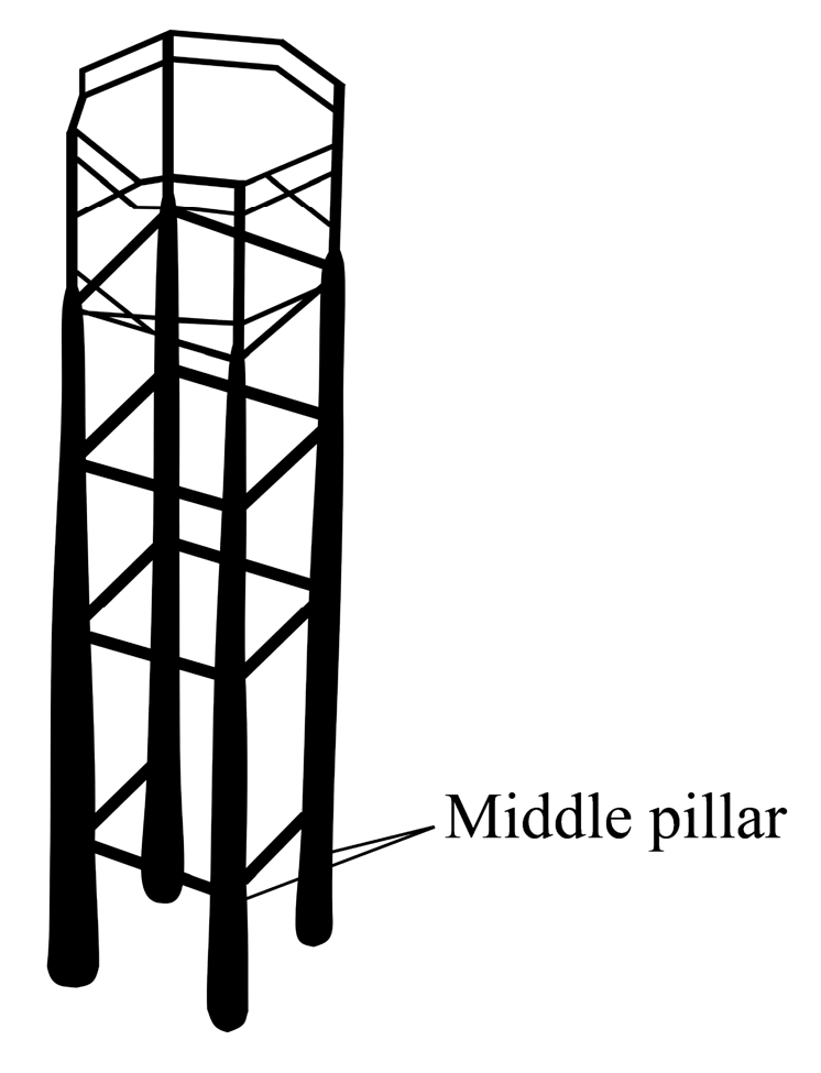
  • Column structure erection: The drum tower’s structural columns are erected in several phases, beginning with the central column (also known as the primary load-bearing column) (as illustrated in Figure 3), followed by the secondary and peripheral columns.
  • Bracket and rafter erection: This stage involves the assembly of brackets known as “1 gua”, “2 gua”, “3 gua”, and so on. Columns and brackets bear the structural load with rafters and beams connecting these elements. Columns and brackets have openings, while rafters and beams are mortised, creating a mortise-and-tenon structure. This feature is fundamental to drum towers and other Dong architectural structures [32].
  • Eave pillar erection: During this phase, peripheral pillars are constructed around the central column.
  • Rafter connections: The rafters are of two kinds: surrounding rafters and through rafters. The former plays the role of pulling and fixing the overall frame, while the latter connects the internal and external frames, effectively interconnecting the column brackets.
  • Pagoda construction: This phase involves the construction of the uppermost part of the pagoda, including the pinnacle and the drum tower platform.

4. Reconstruction of the Internal Construction Engineering Structure of the Zengchong Drum Tower Utilizing On-Site Data and BIM Tools

This section is dedicated to a detailed examination of the revered heritage drum tower known as the Zengchong drum tower. Built in 1672, this architectural masterpiece covers an area of 160 square meters and reaches an impressive height of 25 m. The structure comprises four massive columns, each with a diameter of 0.8 m and a height of 15 m [18]. This analytical work was completed through a combination of on-site measurements and in-depth interviews with local inheritors of drum tower building techniques.
Our methodological framework, guided by the seminal contributions of Ramona Quattrini and her scholarly colleagues [33], intricately interweaves computer software, the transformative potential of BIM tools, and the precision of computer-aided design (CAD) renderings. Through this carefully planned ensemble, we aimed to recreate the complex structure of the Zengchong drum tower in as much detail as possible, as envisioned and executed by insightful local architects of bygone eras.
It is crucial to understand that the illustrations provided here are approximations designed to capture the essence of the architectural narrative of the Zengchong drum tower during its auspicious founding in 1672. They do not claim to be exact replicas. The tower’s rich history, spanning more than three centuries, bears witness to the inevitable passage of time. Unfortunately, the architects of its founding era have long passed, and due to the absence of written records of the design process from that time, certain design details have been lost. This poignant reality emphasizes the significant role of modern digital technology in protecting and preserving the traditional architectural heritage of ethnic minorities.
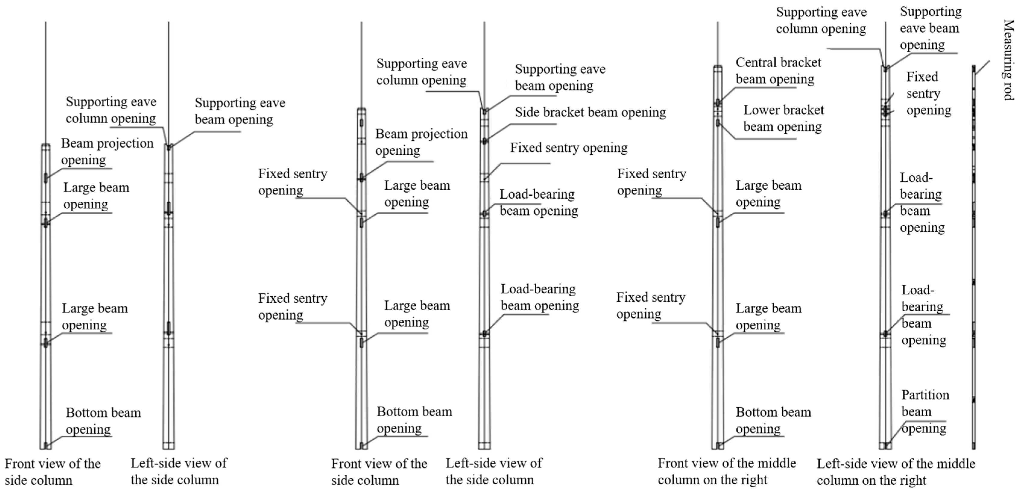
The drum tower’s framework comprises a diverse array of components, including the measuring rod, various types of columns (central columns, “Leigong” columns, eave columns, and bracket columns), rafters, and the ornate finial at the summit. The 2D model data illustrated in Figure 4 are derived from the manual measurement of data pertaining to the various building components of the drum tower. The image displayed is a 2D schematic, created using computer-aided design (CAD) (AutoCAD 2019) software, which illustrates the mortise and tenon positions of the timber posts utilized in the actual construction of the drum tower. It also depicts the use of a measuring rod to facilitate the mortise and tenon of the timber, which is the joint that connects the beams and square beams throughout the architectural design of the drum tower. The measuring rod is a distinctive tool used by ancient Chinese architects in architectural design. It is typically a flat wooden pole with specific dimensions and engravings, serving both design and construction purposes. The primary function of the measuring rod is to mark precise lines for the placement and dimensions of architectural components. Each component corresponds to a specific measuring rod. For instance, during the construction of the Gate of Heavenly Peace in Tiananmen Square, multiple measuring rods were employed to process large logs accurately. Similarly, the construction of Dong drum towers in southwestern China does not rely on design drawings. Instead, these towers are built using measuring rods, as depicted in Figure 4, along with cedar cutouts for the timber columns and gables. The length of these measuring rods are determined by the height of the drum towers, which are inscribed with details of the tenons and mortise holes. Thus, the measuring rods effectively function as the blueprint for constructing the drum towers.
A detailed account of the workflow for the construction of a building information modeling (BIM) model of a drum tower is provided in the following, which involves two main stages: data collection and model construction.

4.1. Data Collection for Structural and Architectural Components

Over time, many construction techniques used in drum towers have been lost due to the lack of written records. Prior to the advent of BIM, technologies such as photography, videography, and 3D scanning had limitations in accurately capturing the precise dimensions and locations of internal structural components, necessitating the use of manual measurements and interviews with local architects. Readers might question the necessity of collaborating with local architects during the data collection process, given the acknowledged loss of knowledge about these construction techniques. There are two primary reasons for this. First, the drum tower under study was built many years ago and certain components have deteriorated over time. Collaborating with local construction experts, who have observed these changes firsthand, was crucial for supplementing missing data with their descriptions. Second, the intricate details, such as the shapes and patterns of structural components, are difficult to capture through measurements alone. These details are closely tied to the daily lives and cultural heritage of the Dong people, making consultations with local experts essential to bridging this data gap. To construct an accurate BIM model of the drum tower, we must gather data related to both its structural components and architectural decorations. This involves a combination of manual measurements and point cloud data acquisition.

4.1.1. Structural Components and Architectural Decorations

Structural components: The drum tower’s structural elements include main bearing columns, beams, beam squares, melon columns, melon squares, and purlins. These components play a crucial role in the tower’s stability and overall design.
Architectural decorations: The tower’s aesthetic features comprise wall panels, phi eaves, hanging pillars, and the treasure roof. These decorative elements contribute to the tower’s historical and cultural significance.

4.1.2. Manual Measurements

Whilst conducting our research on the Dong drum tower, we found that the intricate details and handcrafted features of the structure posed significant challenges for digital measurement tools, such as 3D scanners and drones, in accurately capturing some of the architectural decorations and fine details. Manual measurement proved indispensable for ensuring data precision, particularly in the case of intricate elements such as carvings and textures.
The use of manual measurement techniques provided a more accurate and reliable foundation for the research. For example, the wood carvings and relief decorations on the drum tower are highly detailed, with some located at elevated points or in areas difficult to measure directly using digital tools. To obtain precise dimensional and morphological data for these sections, the researchers employed manual measurement to ensure accurate capture of these details. Furthermore, due to the effects of long-term use and weathering, certain components of the drum tower have undergone slight deformations, which conventional digital tools cannot accurately capture. In these cases, manual measurement offered greater flexibility in recording the true form of these irregular components.

4.1.3. Point Cloud Data

UAV imaging: Unmanned aerial vehicles (UAVs) were employed to capture high-resolution images of the entire drum tower. From these images, we extracted point cloud data—a dense set of 3D coordinates representing the tower’s surfaces. This data allowed us to assess the tower’s overall layout, symmetry, and intricate details.
By combining manual measurements and point cloud data, we established a comprehensive digital archive for the drum tower. This repository serves as the foundation for creating an accurate BIM model that reflects both its structural integrity and architectural beauty.

4.2. Modeling

The BIM model is created using the data collected, employing the BIM module of AutoCAD to produce a digital representation that accurately reflects the drum tower’s actual structure and appearance.
Plan and elevations: Based on the data, floor plans for the drum tower are drafted, detailing levels from the 1st to the 13th floor, including the roof’s apex. This process is depicted in Figure 5c.
Structural model: A detailed structural model of the drum tower is constructed, as shown in Figure 5a.
Sectional drawings: The structural elements are illustrated in sectional views, represented in Figure 5b.
Digital model: A comprehensive digital model of the drum tower is generated using BIM software. This model includes extensive architectural information, providing a detailed virtual representation of the drum tower.
The BIM model of the drum tower is an accurate representation of the actual structure and appearance of the Zengchong drum tower. It provides precise data and technical support for the digital display, protection, and repair and reconstruction of the drum tower.
Subsequently, we employed the capabilities of CAD modeling to meticulously craft detailed architectural construction blueprints for this remarkable 13-tiered drum tower, as elegantly depicted in Figure 5c through Figure 6c. These intricately detailed illustrations aim to present a comprehensive view of the complex structural and aesthetic aspects of the drum tower.
The detailed documentation of the entire construction process of the drum tower is a testament to architectural ingenuity, meticulously depicted in Figure 5c and Figure 6. A comprehensive representation of the simulated drum tower model, encompassing cross-sectional and elevation views, is presented in Figure 5b and Figure 6d.
This research represents a significant contribution to addressing the lack of written documentation concerning historic drum tower construction techniques, which have traditionally been transmitted orally. Essentially, this research takes a critical step toward preserving the intricately built structure within drum towers. Notably, during our academic examination, we were impressed by the architects’ exceptional 3D spatial perception. Their mental blueprints are vivid, tangible, and inherently 3D, as evidenced by the Dong language. The Dong language is marked by a high degree of complexity, particularly in its diverse tonal system and intricate grammatical structure. In a similar vein, the Dong drum towers embody a comparable level of intricacy, as seen in their multi-layered wooden structures, elaborate decorations, and meticulous craftsmanship. Both the language and architecture serve as prominent expressions of Dong culture, showcasing a remarkable sophistication and artistic ingenuity. They demonstrated the ability to navigate and overcome the various challenges inherent in drum tower construction. This serves as a testament to the profound wisdom of the ancient Dong people, as reflected in the construction techniques of the drum tower.

5. 3D Reconstruction of Drum Tower Exterior Profiles Using Point Cloud Data

In this section, we reconstruct the external profiles of four distinct drum towers from precise point cloud data: the Chaoli drum tower, the Zeli drum tower, the Congjiang drum tower, and the Zengchong drum tower. The reconstruction process is outlined in Figure 7. The gray arrows in the figure indicate the transition between each phase of the process, from the initial acquisition of point cloud data to the final creation of fully realized 3D models. Each phase builds on the previous one, following a logical progression from data collection, through processing, to the generation of the final models. The following paragraphs describe each of these phases in detail.

5.1. Data Acquisition and Pre-Processing

This study employed both video and photographic techniques at various stages of the investigation to achieve a comprehensive documentation of the drum tower’s architectural features. Video technology was utilized to capture a dynamic overview of the overall structure and its interaction with the surrounding environment. The continuous nature of video recording provided an extensive perspective on the building’s layout and spatial context. In contrast, photography was employed for detailed examination, enabling precise documentation of the drum tower’s decorations and materials due to its high resolution and static imaging capability. The combined use of video and photography ensured thorough documentation at both macro and micro levels. This multi-method approach facilitated a robust, multi-dimensional analysis of the drum tower’s architectural characteristics.
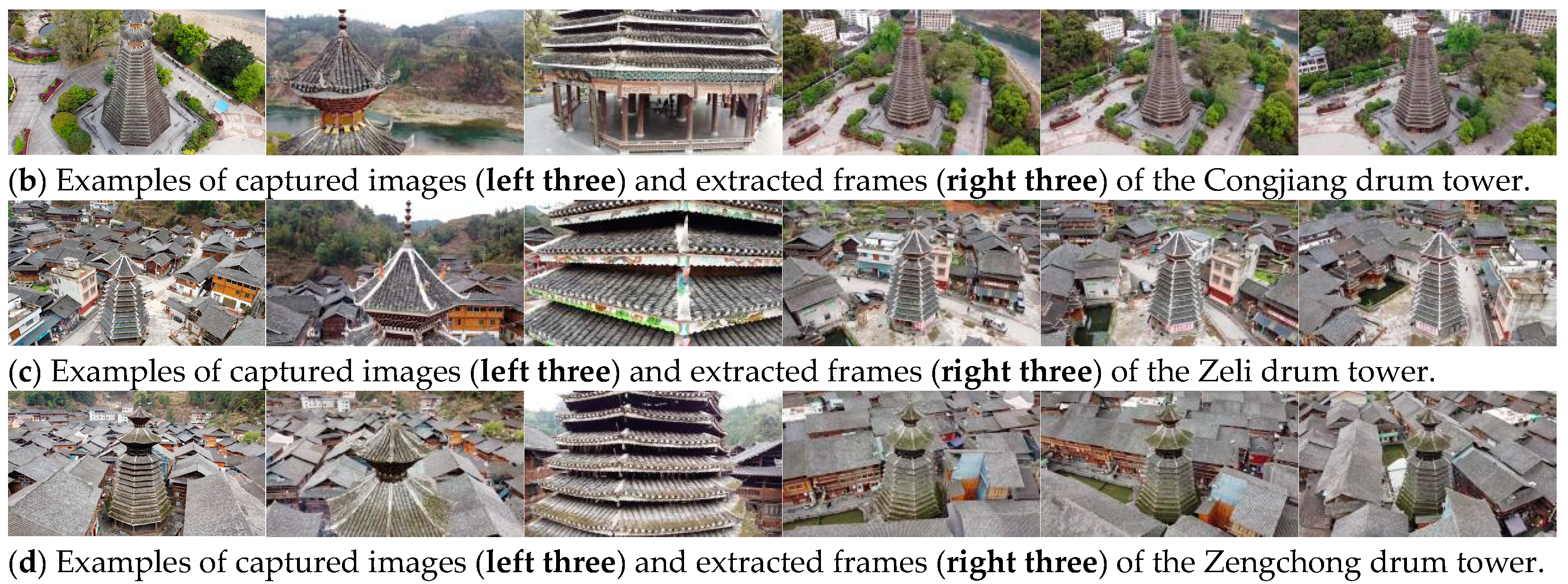
The data were acquired by a DJI AIR2s UAV with the following two data acquisition modes: (1) sequential video recording for overall survey and (2) unordered image capture for local observation, on four drum towers, named Chaoli, Congjiang, Zeli, and Zengchong. For video recording, a different number of flights with different flight heights are conducted on different scenes. In order to combine the video and image data for uniform 3D reconstruction of the drum towers, the recorded videos were further extracted to frames using FFmpeg, and the extraction rate is set to 1 frame per second (FPS) in this paper to make a tradeoff between computational efficiency and information fidelity. Examples of images and extracted video frames of the Chaoli, Congjiang, Zeli, and Zengchong drum towers are shown in Figure 8, and the associated metadata, including the number of captured images and extracted frames, average overlaps between adjacent images, ground sampling distances (GSDs), and flight heights of the acquired data on each drum tower is listed in Table 1.

5.2. Drum Tower 3D Reconstruction

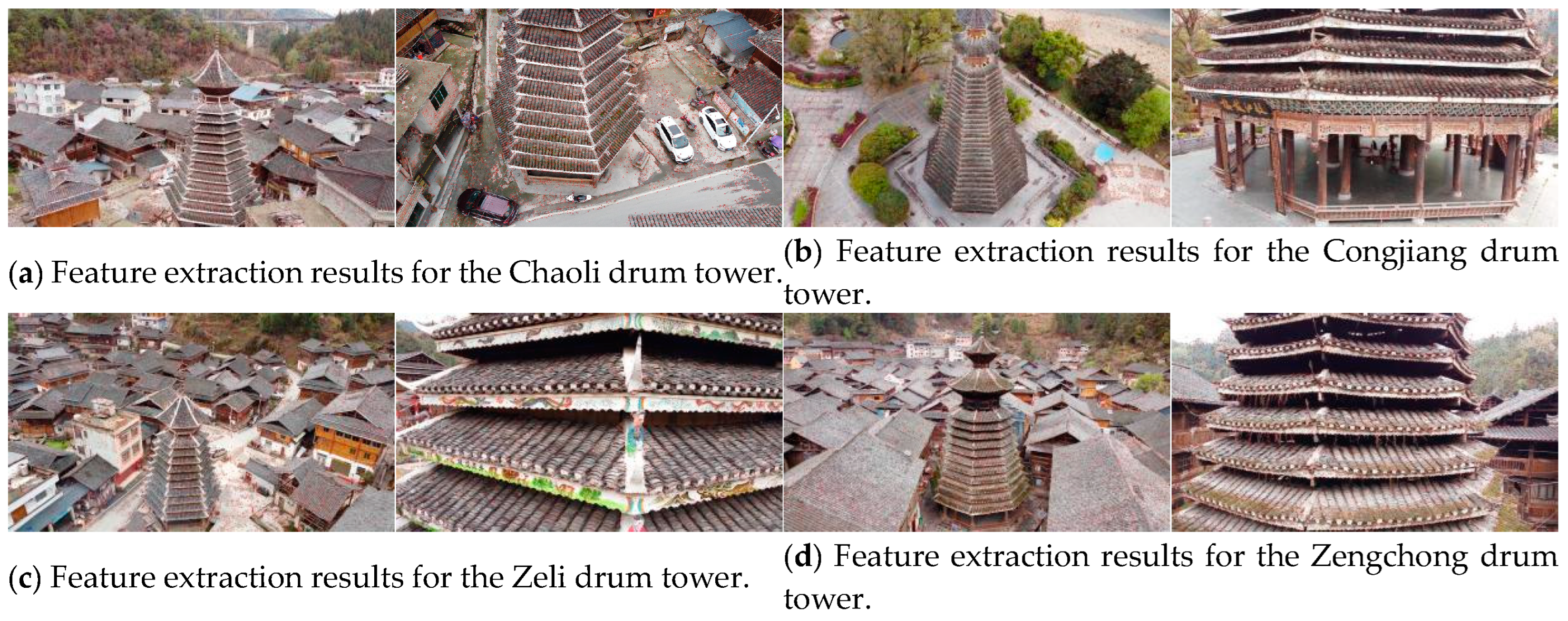
Given the captured images and extracted video frames of the drum towers of Chaoli, Congjiang, Zeli, and Zengchong, COLMAP, an end-to-end, general-purpose image-based 3D reconstruction software, was employed to generate their dense reconstructions. Specifically, scale invariant feature transform (SIFT) [34] feature detection and description were performed on each image to obtain the local image features; sample results for each drum tower are shown in Figure 9, with the red dots denoting the extracted feature points. SIFT is known to be robust towards rotation, scale, and to some extent, viewpoint changes. Then, to accelerate the image matching process, vocabulary tree-based image retrieval [35] was performed to obtain a set of potential matched images for each image, and feature matching was performed between them to obtain pair-wise image feature matches using a nearest neighbor search algorithm, namely fast library for approximate nearest neighbors (FLANN) [36]. Sample feature-matching results for all the drum towers are shown in Figure 10, wherein the green line segments link the matched feature points.
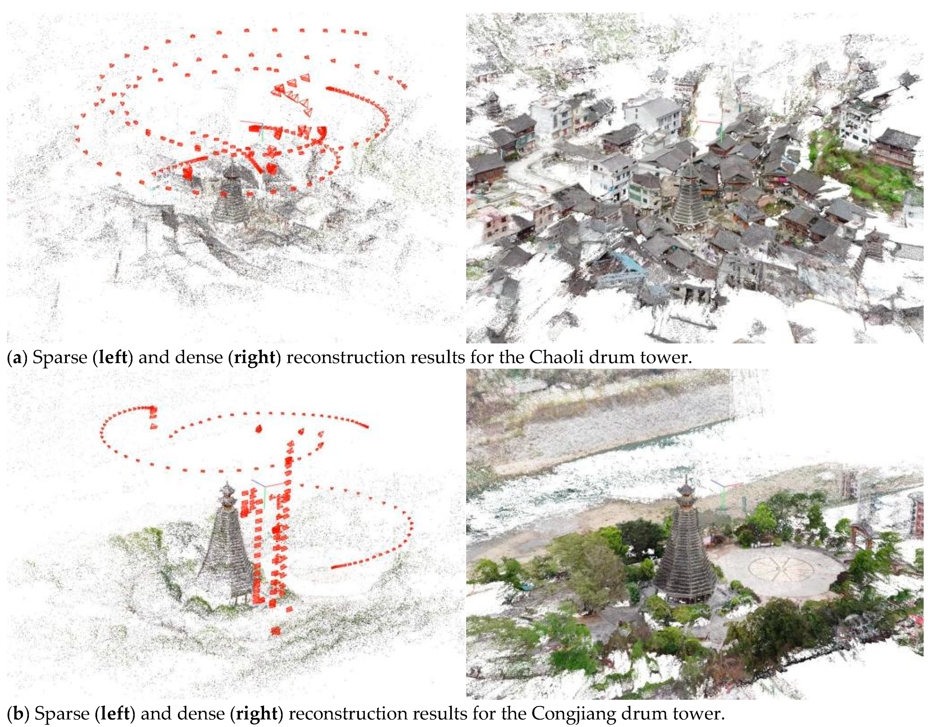
Subsequently, incremental structure from motion (SfM) [37] was conducted given the feature matches via iterative Perspective-n-Point (PnP)-based camera registration [38], multiple view triangulation-based scene expansion [39], and bundle adjustment (BA)-based parameter optimization [40]. The above iteration, including camera registration, scene expansion, and parameter optimization, is performed until either all cameras have been calibrated or no more cameras could be registered further. Figure 11 illustrates the sparse scene reconstruction result of each drum tower, wherein the red rectangular pyramids denote the recovered camera poses.
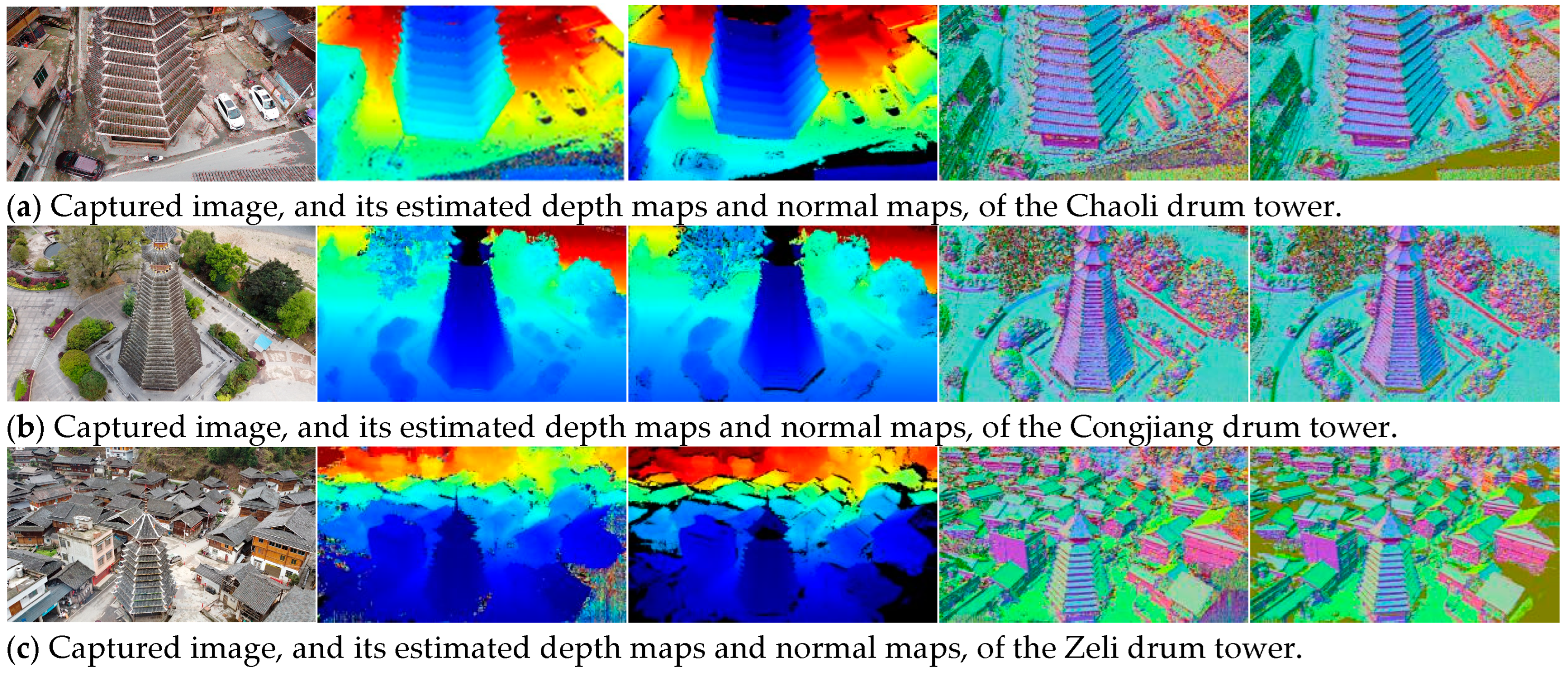
Based on the camera pose estimates and scene sparse representations produced by the incremental SfM procedure, multiple view stereo (MVS) [41] was performed, in which the depth and normal map of each rectified image was estimated from photometric [42] and geometric [43] consistency, and all of them were fused to generate dense models. An example of a captured image and its estimated depth maps and normal maps of each drum tower are shown in Figure 12, and the dense reconstruction results are shown in Figure 11. It could be observed from Figure 11 and Figure 12 that the camera poses are well estimated, the depth and normal maps are correctly computed, and the scene structures are properly recovered. All the above 3D reconstruction processes of the drum towers, including feature extraction and matching and 3D scene sparse and dense reconstruction, are conducted with the COLMAP toolbox with the default parameter setting.
To evaluate the accuracy of the reconstructed point clouds, they are geo-registered by the ground control points (GCPs). Specifically, for the drum towers of Congjiang and Zengchong, twenty GCPs are marked and measured by a high-accuracy differentiable GPS equipment, Qianxun SR6 Plus, with a positioning error under 1 cm. Some examples of the GCPs for both Congjiang and Zengchong are marked as red crosses in Figure 13. When performing the geo-registration, all twenty GCPs are manually labeled in the point cloud, and ten of them are randomly selected, by which the similarity transformation between the local and GPS coordinates systems are estimated [44]. Then, the median, mean, and root-mean-square (RMS) alignment distances of the remaining ten GCPs are served as the reconstruction accuracy metrics. The values of them are shown in Table 2, in which the relatively high accuracies of the reconstructed point clouds are demonstrated.

6. Discussions and Conclusions

This study presents an innovative conservation framework designed to preserve endangered heritage architecture, with a focus on the drum towers of the Dong ethnic group. By integrating building information modeling (BIM) tools and drone-based oblique photography, this framework facilitates the reconstruction of both internal structural components and external dimensions of these towers. The practical application of this framework was demonstrated through the case study of the Zengchong drum tower.
In Section 4, we detailed the construction techniques and procedures used to simulate and reconstruct the structural characteristics of the drum towers, resulting in an internal engineering model that accurately reflects the original construction methods. Section 5 covered the acquisition of external point cloud data through drone oblique photography and 2D imaging. By employing feature extraction, matching, and fusion techniques, we successfully achieved 3D reconstructions of four prominent drum towers: Chaoli, Zeli, Congjiang, and Zengchong. This study highlights two primary advantages of the proposed framework. First, it offers an effective solution for repair and reconstruction when historical records or construction drawings are unavailable, ensuring the preservation of endangered architectural heritage even in the absence of documentation. Second, the framework provides a reliable method for assessing and documenting inaccessible or hazardous areas, thereby improving efficiency and safety compared to traditional, labor-intensive techniques.
Despite these benefits, there is reluctance to adopt BIM and UAV technology for preserving minority heritage buildings, likely due to a lack of awareness, limited time to learn new technologies, and insufficient funding and technical personnel. This study uses authentic drum towers from traditional Dong villages in Southwest China to validate the feasibility and practicality of this approach. It demonstrates how modern digital tools can be accessible for cultural anthropologists and conservation experts, facilitating the preservation of similar heritage buildings.
However, this study also acknowledges several limitations. BIM is approximate due to the lost intricacies of the construction process, which were traditionally passed down orally. In addition, the 3D scene reconstruction results based on airborne imagery are often deficient in detailed features of towers and the structures beneath eaves. These missing elements could be effectively supplemented by incorporating ground-level images, which provide a closer and more comprehensive perspective. Last but not the least, it is preferred to provide the ground-truth geometric structures of the drum towers involved in this work with a high-accuracy laser scanner, by which the accuracy of the image-based 3D models could be credibly evaluated. Addressing these limitations in future research will enhance the robustness and applicability of this conservation framework.

Author Contributions

Conceptualization, W.H.; methodology, W.H.; software, X.G.; validation, J.L.; formal analysis, X.G.; investigation, J.L.; resources, J.L.; data curation, J.L.; writing—original draft preparation, W.H.; writing—review and editing, X.G.; visualization, X.G.; project administration, W.H.; funding acquisition, W.H. All authors have read and agreed to the published version of the manuscript.

Funding

This research was funded by Qiandongnan Science and Technology Bureau (Qiandongnan kejichu [2021]20); the National Natural Science Foundation of China, grant number 62373349; and the National Social Science Foundation of China, grant number 22BMZ162.

Data Availability Statement

The data that support the findings of this article are available from the authors upon reasonable request.

Acknowledgments

Our sincere appreciation goes to the Qian Dongnan Design Institute and esteemed scholars from Kaili University’s School of Architecture and Engineering, with special recognition of the invaluable contributions by Pan Changren. It is through their unwavering support that this digital compendium, capturing the intricate nuances of the drum tower’s internal construction techniques, achieves the status of a significant milestone.

Conflicts of Interest

Author Jiaguo Lu was employed by the company Qiandongnan Prefecture Architectural Design Institute Limited Liability Company. The remaining authors declare that the research was conducted in the absence of any commercial or financial relationships that could be construed as a potential conflict of interest.

References

  1. Havinga, L.; Colenbrander, B.; Schellen, H. Heritage significance and the identification of attributes to preserve in a sustainable refurbishment. J. Cult. Herit. 2020, 43, 282–293. [Google Scholar] [CrossRef]
  2. Bedate, A.; Herrero, L.C.; Sanz, J.A. Economic valuation of the cultural heritage: Application to four case studies in Spain. J. Cult. Herit. 2004, 5, 101–111. [Google Scholar] [CrossRef]
  3. UNESCO. World Heritage in Danger; UNESCO: Paris, France, 2020. [Google Scholar]
  4. Raghav, N.; Mamta; Shrivastava, J.N.; Satsangi, G.P.; Kumar, R. Enumeration and characterization of airborne microbial communities in an outdoor environment of the city of Taj, India. Urban Clim. 2020, 32, 100596. [Google Scholar] [CrossRef]
  5. Zhang, H.P.; Luo, Y.C.; Yao, R.H. Research on the structure and construction techniques of Dong ethnic drum towers. J. Hist. Sci. Technol. China 2012, 33, 190–203. [Google Scholar]
  6. Huang, W.T.; Yang, X.B.; Luo, Y.C. Internet plus and the spread of Miao and Dong ethnic mathematical culture. J. Kaili Univ. 2017, 35, 5–7. [Google Scholar]
  7. Duan, J.; Shao, R.; Lan, W.; Liu, J.; Jiang, Y. Spatial genes. Urban Plan. 2019, 43, 14–21. [Google Scholar]
  8. Guizhou Provincial Cultural Relics Management Office, Guizhou Provincial Cultural Publishing House Heritage Department. Research on Dong Village Drum Towers; Guizhou People’s Publishing House: Guiyang, China, 1985; pp. 32, 41.
  9. Luo, Y.C. Aspects of the mathematical culture of the Dong nationality. J. Math. Educ. 2013, 22, 67–72. [Google Scholar]
  10. Wu, L. A Documentary Record of Traditional Construction Techniques of Dong Ethnic Drum Towers in Congjiang; China Cultural and Historical Publishing House: Beijing, China, 2012; p. 147. [Google Scholar]
  11. Thomson, N.; Banfill, P. Corrugated-iron buildings: An endangered resource within the built heritage. J. Archit. Conserv. 2005, 11, 71–87. [Google Scholar] [CrossRef]
  12. Selim, M.; Abulnour, A.; Eldeeb, S. The revitalization of endangered heritage buildings in developing countries: A decision-making framework for investment and determining the highest and best use in Egypt. F1000 Res. 2023, 12, 874. [Google Scholar] [CrossRef]
  13. Liu, F.; Kang, J.; Wu, Y.; Yang, D.; Meng, Q. What do we visually focus on in a World Heritage Site? A case study in the Historic Centre of Prague. Humanit. Soc. Sci. Commun. 2022, 9, 1–16. [Google Scholar] [CrossRef]
  14. Masoud, E.; Gharipour, M. Developing a model to weigh cultural values in the adaptive reuse of heritage buildings: The case of the Risbaf Factory in Isfahan, Iran. J. Inst. Conserv. 2022, 45, 105–121. [Google Scholar] [CrossRef]
  15. Bañuelos, J.K.; Miranda, Á.R.; Valle-Melón, J.M.; Zornoza-Indart, A.; Castellano-Román, M.; Angulo-Fornos, R.; Pinto-Puerto, F.; Ibáñez, P.A.; Ferreira-Lopes, P. The role of information management for the sustainable conservation of cultural heritage. Sustainability 2021, 13, 4325. [Google Scholar] [CrossRef]
  16. Tse, R.; Aguiari, D.; Chou, K.S.; Giusto, D.; Tang, S.K.; Giovanni, P. Monitoring cultural heritage buildings via low-cost edge computing/sensing platforms: The Biblioteca Joanina de Coimbra case study. In Proceedings of the Goodtechs ’18: 4th EAI International Conference, Bologna, Italy, 28–30 November 2018; pp. 148–152. [Google Scholar] [CrossRef]
  17. Rebec, K.M.; Deanovič, B.; Oostwegel, L. Old buildings need new ideas: Holistic integration of conservation-restoration process data using heritage building information modelling. J. Cult. Herit. 2022, 55, 30–42. [Google Scholar] [CrossRef]
  18. Soler, F.; Melero, F.J.; Luzón, M.V. A complete 3D information system for cultural heritage documentation. J. Cult. Herit. 2017, 23, 49–57. [Google Scholar] [CrossRef]
  19. Guo, Q.; Liu, H.; Hassan, F.M.; Bhatt, M.W.; Buttar, A.M. Application of UAV tilt photogrammetry in 3D modeling of ancient buildings. Int. J. Syst. Assur. Eng. Manag. 2022, 13 (Suppl. 1), 424–436. [Google Scholar] [CrossRef]
  20. Youn, H.C.; Yoon, J.S.; Ryoo, S.L. HBIM for the characteristics of Korean traditional wooden architecture: Bracket set modelling based on 3d scanning. Buildings 2021, 11, 506. [Google Scholar] [CrossRef]
  21. Yilmaz, H.M.; Yakar, M.; Gulec, S.A.; Dulgerler, O.N. Importance of digital close-range photogrammetry in documentation of cultural heritage. J. Cult. Herit. 2007, 8, 428–433. [Google Scholar] [CrossRef]
  22. Dipasquale, L.; Carta, M.; Galassi, S.; Merlo, A. The vernacular heritage of Gjirokastra (Albania): Analysis of urban and constructive features, threats and conservation strategies. Int. Arch. Photogramm. Remote Sens. Spat. Inf. Sci. 2020, XLIV-M-1–2020, 33–40. [Google Scholar] [CrossRef]
  23. Guiducci, F.; Sweek, T.; Anderson, J. Finding sustainability in the desert: Conservation of the archaeological site of Dangeil, Sudan, and its associated collections. Stud. Conserv. 2020, 65 (Suppl. 1), 113–118. [Google Scholar] [CrossRef]
  24. López, J.J.; Pázmány, M.M. Drones for Conservation in Protected Areas: Present and Future. Drones 2019, 3, 10. [Google Scholar] [CrossRef]
  25. Luhmann, T.; Chizhova, M.; Gorkovchuk, D. Fusion of UAV and Terrestrial Photogrammetry with Laser Scanning for 3D Reconstruction of Historic Churches in Georgia. Drones 2020, 4, 53. [Google Scholar] [CrossRef]
  26. Mia, M.C.; Laso, F.J.; Javier, A.N. Drone-Based Participatory Mapping: Examining Local Agricultural Knowledge in the Galapagos. Drones 2020, 4, 62. [Google Scholar] [CrossRef]
  27. Mishra, M. Machine learning techniques for structural health monitoring of heritage buildings: A state-of-the-art review and case studies. J. Cult. Herit. 2021, 47, 227–245. [Google Scholar] [CrossRef]
  28. Khodeir, L.M.; Aly, D.; Tarek, S. Integrating HBIM (heritage building information modeling) tools in the application of sustainable retrofitting of heritage buildings in Egypt. Procedia Environ. Sci. 2016, 34, 258–270. [Google Scholar] [CrossRef]
  29. Brumana, R.; Della Torre, S.; Previtali, M.; Barazzetti, L.; Cantini, L.; Oreni, D.; Banfi, F. Generative HBIM modelling to embody complexity (LOD, LOG, LOA, LOI): Surveying, preservation, site intervention—The Basilica di Collemaggio (L’Aquila). Appl. Geomant. 2018, 10, 545–567. [Google Scholar] [CrossRef]
  30. Hajirasouli, A.; Banihashemi, S.; Kumarasuriyar, A.; Talebi, S.; Tabadkani, A. Virtual reality-based digitisation for endangered heritage sites: Theoretical framework and application. J. Cult. Herit. 2021, 49, 140–151. [Google Scholar] [CrossRef]
  31. Yang, Y.; Wu, K.; Yang, F. Dong Ethnic Drum Towers in China; Guangxi Nationalities Publishing House: Nanning, China, 2008; pp. 40–41. [Google Scholar]
  32. Luo, D. Guizhou Vernacular Dwellings; China Architecture & Building Press: Beijing, China, 2008. [Google Scholar]
  33. Quattrini, R.; Baleani, E. Theoretical background and historical analysis for 3D reconstruction model, Villa Thiene at Cicogna. J. Cult. Herit. 2015, 16, 119–125. [Google Scholar] [CrossRef]
  34. Lowe, D.G. Distinctive image features from scale-invariant keypoints. Int. J. Comput. Vis. 2004, 60, 91–110. [Google Scholar] [CrossRef]
  35. Schönberger, J.L.; Price, T.; Sattler, T.; Frahm, J.M.; Pollefeys, M. A vote-and-verify strategy for fast spatial verification in image retrieval. In Proceedings of the Asian Conference Computer Vision (ACCV), Taipei, Taiwan, 20–24 November 2016; pp. 321–337. [Google Scholar] [CrossRef]
  36. Muja, M.; Lowe, D.G. Scalable nearest neighbor algorithms for high dimensional data. IEEE Trans. Pattern Anal. Mach. Intell. 2014, 36, 2227–2240. [Google Scholar] [CrossRef]
  37. Schönberger, J.L.; Frahm, J.M. Structure-from-motion revisited. In Proceedings of the IEEE Conference on Computer Vision and Pattern Recognition (CVPR), Las Vegas, NV, USA, 27–30 June 2016; pp. 4104–4113. [Google Scholar] [CrossRef]
  38. Gao, X.; Hou, X.; Tang, J.; Cheng, H. Complete solution classification for the perspective-three-point problem. IEEE Trans. Pattern Anal. Mach. Intell. 2003, 25, 930–943. [Google Scholar] [CrossRef]
  39. Hartley, R.I.; Sturm, P. Triangulation. Comput. Vis. Image Underst. 1997, 68, 146–157. [Google Scholar] [CrossRef]
  40. Agarwal, S.; Snavely, N.; Seitz, S.M.; Szeliski, R. Bundle adjustment in the large. In Proceedings of the European Conference on Computer Vision (ECCV), Heraklion, Greece, 5–11 September 2010; pp. 29–42. [Google Scholar] [CrossRef]
  41. Schönberger, J.L.; Zheng, E.; Frahm, J.M.; Pollefeys, M. Pixelwise view selection for unstructured multi-view stereo. In Proceedings of the European Conference on Computer Vision (ECCV), Amsterdam, The Netherlands, 11–14 October 2016; pp. 501–518. [Google Scholar] [CrossRef]
  42. Zheng, E.; Dunn, E.; Jojic, V.; Frahm, J.M. PatchMatch based joint view selection and depthmap estimation. In Proceedings of the IEEE Conference on Computer Vision and Pattern Recognition (CVPR), Columbus, OH, USA, 23–28 June 2014; pp. 1510–1517. [Google Scholar] [CrossRef]
  43. Zhang, G.; Jia, J.; Wong, T.T.; Bao, H. Recovering consistent video depth maps via bundle optimization. In Proceedings of the IEEE Conference on Computer Vision and Pattern Recognition (CVPR), Anchorage, AK, USA, 23–28 June 2008; pp. 1–8. [Google Scholar] [CrossRef]
  44. Umeyama, S. Least-squares estimation of transformation parameters between two point patterns. IEEE Trans. Pattern Anal. Mach. Intell. 1991, 13, 376–380. [Google Scholar] [CrossRef]
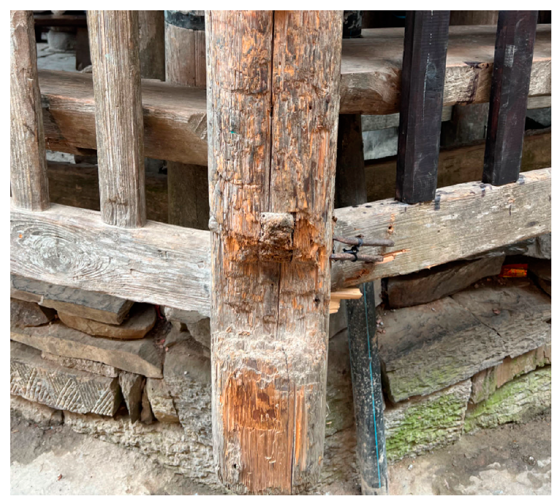
Figure 1. Corner features of the Zengchong drum tower.
Drones 08 00502 g001
Figure 2. Dong community members congregating inside it.
Drones 08 00502 g002
Figure 3. The tower’s central pillar.
Drones 08 00502 g003
Figure 4. Mortise and notch locations on columns and brackets.
Drones 08 00502 g004
Figure 5. (a) Schematic drum tower structure, (b) cross-sectional elevation, and (c) plan sections from the ground floor to the 13th floor.
Drones 08 00502 g005
Figure 6. (a) Drum tower roof plan, (b) connection between the drip bracket, bracket columns, and eave columns, (c) connection between columns, rafters, and fastening pins, and (d) elevation of the simulated drum tower model.
Drones 08 00502 g006
Figure 7. 3D reconstruction process of drum tower exterior.
Drones 08 00502 g007
Figure 8. Examples of captured images and extracted frames of the drum towers to be reconstructed.
Drones 08 00502 g008aDrones 08 00502 g008b
Figure 9. Examples of SIFT feature extraction results of the drum towers to be reconstructed.
Drones 08 00502 g009
Figure 10. Examples of SIFT feature-matching results.
Drones 08 00502 g010
Figure 11. Sparse and dense reconstruction results.
Drones 08 00502 g011aDrones 08 00502 g011b
Figure 12. Image examples (first column) and their estimated depth and normal maps based on photometric (second and fourth columns) and geometric (third and fifth columns) consistency.
Drones 08 00502 g012aDrones 08 00502 g012b
Figure 13. Examples of GCPs for the Congjiang and Zengchong drum towers.
Drones 08 00502 g013
Table 1. Metadata of the acquired data for drum tower 3D reconstruction.
ChaoliCongjiangZeliZengchong
# captured images33969986
# extracted frames19194115159
Overlaps75%70%80%80%
GSDs4.35 cm3.27 cm2.96 cm3.54 cm
Flight heights80 m/70 m/60 m/50 m70 m/60 m/40 m50/40 m/30 m75 m/50 m/40 m/30 m
Table 2. Drum tower 3D reconstruction accuracy analysis based on ground control points (GCPs) for Congjiang and Zengchong.
Median DistancesMean DistancesRMS Distances
Congjiang2.64 cm3.68 cm5.31 cm
Zenchong3.78 cm4.14 cm4.64 cm
Disclaimer/Publisher’s Note: The statements, opinions and data contained in all publications are solely those of the individual author(s) and contributor(s) and not of MDPI and/or the editor(s). MDPI and/or the editor(s) disclaim responsibility for any injury to people or property resulting from any ideas, methods, instructions or products referred to in the content.