Use of Participatory sUAS in Resilient Socioecological Systems (SES) Research: A Review and Case Study from the Southern Great Plains, USA
Abstract
1. Introduction
2. Literature Review
2.1. Participatory Research in the Geospatial Sciences
2.2. The Role of sUAS in Socioecological Systems (SES) Research
2.3. Participatory sUAS
| Publication | Topic | Platform | Participatory Approach |
|---|---|---|---|
| Brandt et al. [58] | Disaster Risk Management | n/a | Data interpretation |
| Colloredo-Mansfeld et al. [61] | Agroecosystem Analysis | Multirotor | Data acquisition and interpretation |
| Dinko, Nyantakyi-Frimpong [62] | Agroecosystem Analysis | Multirotor | Site selection, data acquisition and interpretation |
| Kleinschroth et al. [63] | Urban or Land Use Planning | Fixed Wing and Multirotor | Site selection and interpretation |
| Larrain et al. [67] | Landscape Archeology | Multirotor | Site selection |
| Li and Deliberty [59] | Disaster Risk Management | Multirotor | Data interpretation |
| Luo et al. [64] | Urban or Land Use Planning | Multirotor | Data interpretation |
| Naufal et al. [65] | Urban or Land Use Planning | Fixed Wing | Data interpretation |
| Paneque-Gálvez et al. [68] | Environmental Justice and Sustainability | Fixed Wing and Multirotor | Site selection, data acquisition and interpretation |
| Radjawali et al. [69] | Counter-mapping | Multirotor | Data acquisition and interpretation |
| Saputra et al. [60] | Disaster Risk Management | Multirotor | Data interpretation |
| Skondras et al. [66] | Urban or Land Use Planning | Multirotor | Data interpretation |
3. Case Study
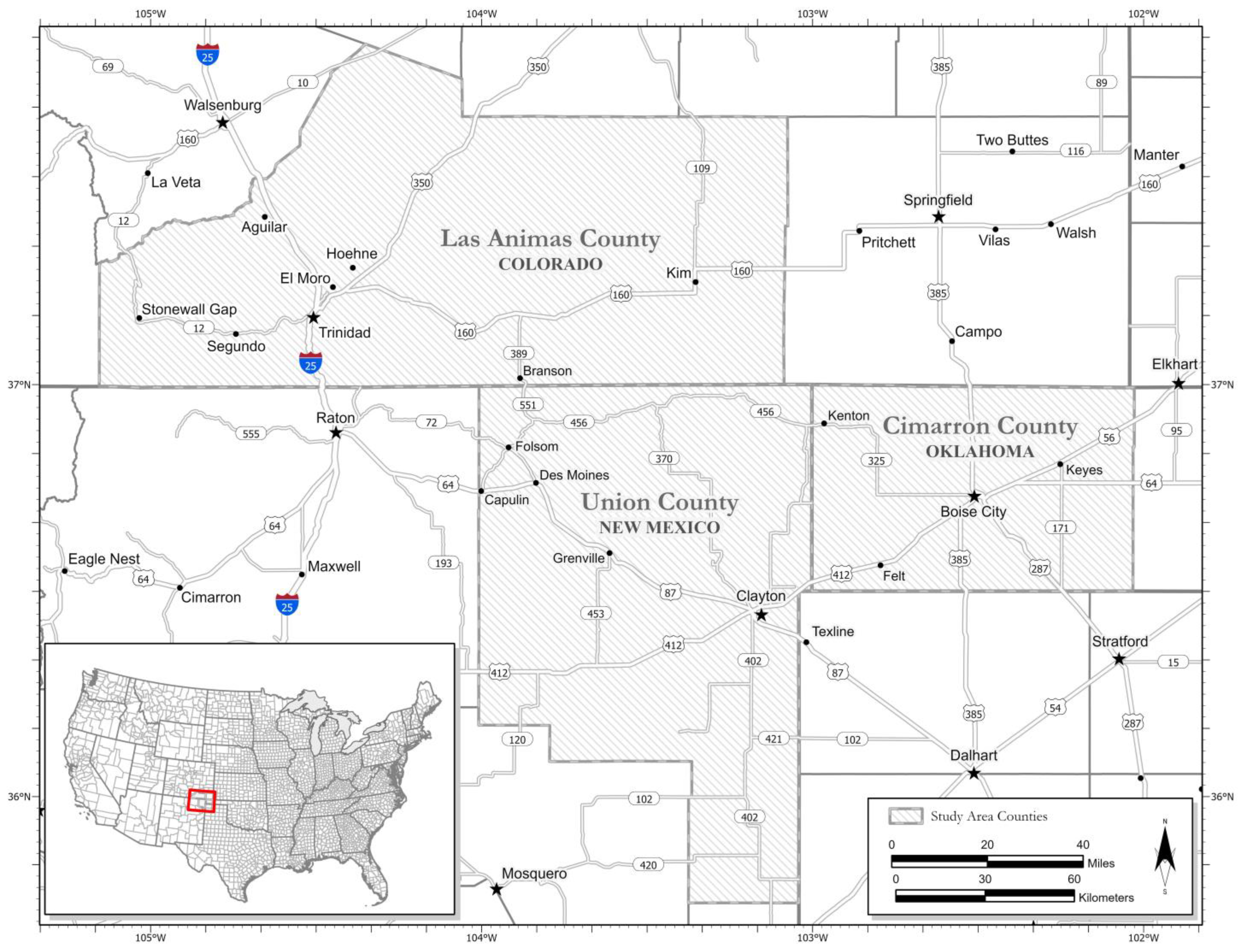
3.1. Participatory sUAS: An Example from the Southern Great Plains
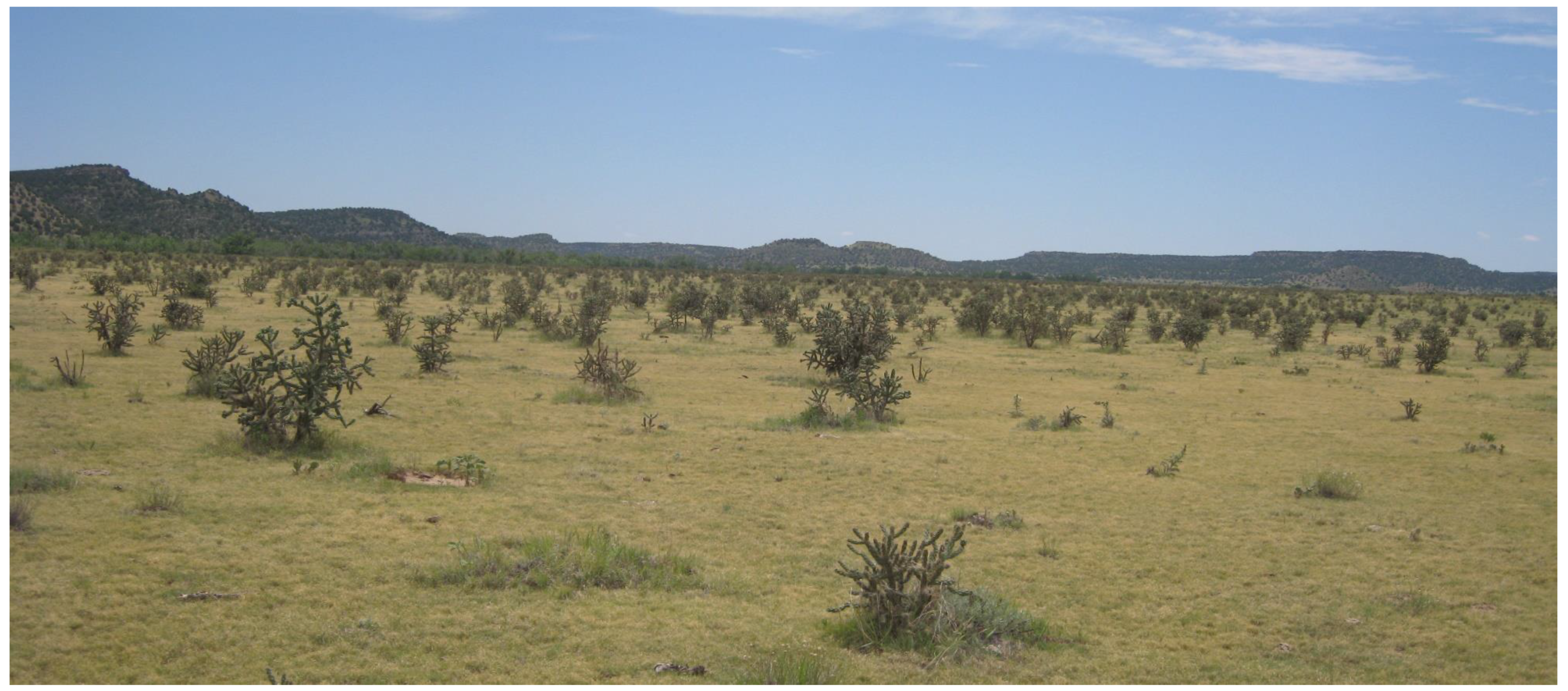
3.1.1. Background
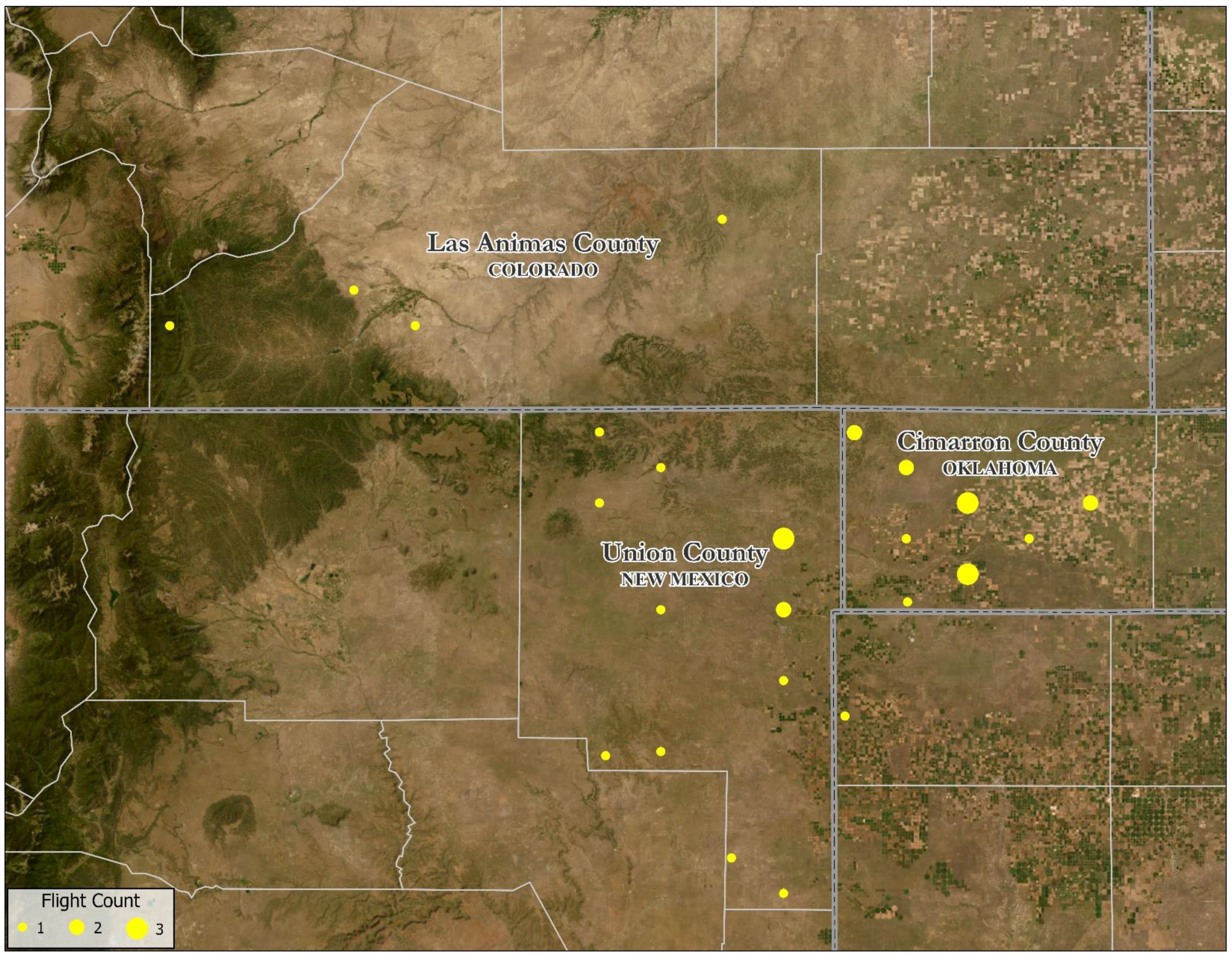
3.1.2. sUAS Surveys
3.1.3. Post-Processing and Image Distribution
4. Results and Discussion
4.1. Opportunities and Challenges
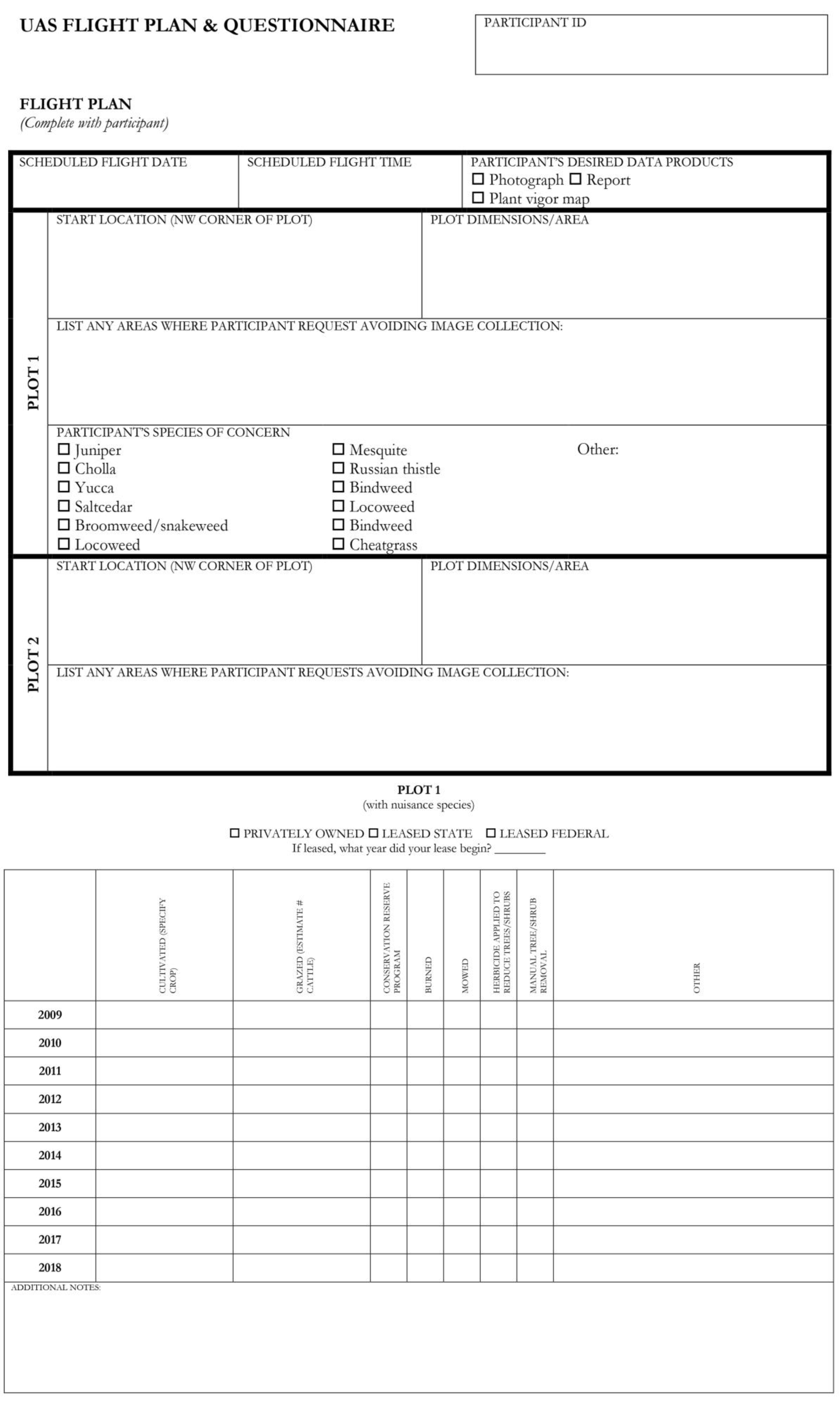
4.1.1. Mission Planning
4.1.2. Stakeholder Engagement and Social Capital
4.1.3. Hardware Failure
4.2. Lessons Learned: The Pursuit of a Truly Participatory sUAS
5. Conclusions
Author Contributions
Funding
Data Availability Statement
Acknowledgments
Conflicts of Interest
References
- Semenchuk, P.; Plutzar, C.; Kastner, T.; Matej, S.; Bidoglio, G.; Erb, K.-H.; Essl, F.; Haberl, H.; Wessely, J.; Kraismann, F.; et al. Relative effects of land conversion and land-use intensity on terrestrial vertebrate diversity. Nat. Commun. 2022, 13, 615. [Google Scholar] [CrossRef] [PubMed]
- Munche, M.; Yemata, G.; Molla, E.; Adnew, W.; Muasya, A.M. Land use and land cover changes and their impact on ecosystem service values in the north-eastern highlands of Ethiopia. PLoS ONE 2023, 18, e0289962. [Google Scholar] [CrossRef] [PubMed]
- Piekle, R.A.; Mahmood, R.; McAlpine, C. Land’s complex role in climate Change. Phys. Today 2016, 69, 40–46. [Google Scholar] [CrossRef]
- Vadjunec, J.M.; Radel, C.; Tuner II, B.L. Introduction: The continued importance of smallholders today. Land 2016, 5, 34. [Google Scholar] [CrossRef]
- Montgomery, D.R. Soil Erosion and agricultural sustainability. Proc. Natl. Acad. Sci. USA 2007, 104, 13268–13272. [Google Scholar] [CrossRef]
- Busch, J.; Ferretti-Gallon, K. What drives deforestation and what stops it? A meta-analysis. Rev. Environ. Econ. Policy 2017, 11, 3–23. [Google Scholar] [CrossRef]
- Wenger, K.; Vadjunec, J.M.; Fagin, T.D. Groundwater governance and the growth of center pivot irrigation in Cimarron County, OK and Union County, NM: Implications for community vulnerability to drought. Water 2017, 9, 39. [Google Scholar] [CrossRef]
- Archer, S.R.; Anderson, E.M.; Predick, K.L.; Schwinning, S.; Steidl, R.J.; Woods, S.R. Woody plant encroachment: Causes and consequences. In Rangeland Systems; Briske, D.D., Ed.; Springer: Cham Switerland, 2017; pp. 25–84. [Google Scholar]
- Vadjunec, J.M.; Colston, N.M.; Fagin, T.D.; Boardman, A. Fostering resilience and adaptation to drought in the Southern High Plains: Using participatory methods for more robust citizen science. Sustainability 2022, 14, 1813. [Google Scholar] [CrossRef]
- Keys, E. Exploring market-based development: Market intermediaries and farmers in Calakmul, Mexico. Geogr. Rev. 2005, 95, 24–46. [Google Scholar] [CrossRef]
- Vadjunec, J.M.; Rocheleau, D. Beyond Forest Cover: Land Use and Biodiversity in Rubber Trail Forests of the Chico Mendes Extractive Reserve. Ecol. Soc. 2009, 14, 29. Available online: http://www.ecologyandsociety.org/vol14/iss2/art29/ (accessed on 1 April 2019). [CrossRef]
- Vadjunec, J.M.; Sheehan, R. Ranching and state school land in Cimarron County, Oklahoma. Gt. Plains Res. 2010, 20, 163–177. [Google Scholar]
- Brannstrom, C.; Vadjunec, J.M. Notes for Avoiding A Missed Opportunity in Sustainability Science: Integrating Land Change Science and Political Ecology. In Land Change Science, Political Ecology, and Sustainability; Brannstrom, C., Vadjunec, J.M., Eds.; Routledge: New York, NY, USA, 2013; pp. 1–23. [Google Scholar]
- Ohly, H.; Ibrahim, Z.; Liyanage, C.; Carmichael, A. A scoping review of participatory research methods in agroecology studies conducted in South Asia. Agroecol. Sustain. Food Syst. 2023, 47, 306–326. [Google Scholar] [CrossRef]
- Freire, P. Pedagogy of the Oppressed, 30th Anniversary ed.; The Continuum International Publishing Group: New York, NY, USA, 2000. [Google Scholar]
- Rambaldi, G.; Kyem, P.A.K.; McCall, M.; Weiner, D. Participatory spatial information management and communication in developing countries. Electron. J. Inform. Syst. Dev. Ctries. 2006, 25, 1–9. [Google Scholar] [CrossRef]
- Rocheleau, D. Maps, numbers, text, and context: Mixing methods in feminist political ecology. Prof. Geogr. 1995, 47, 458–466. [Google Scholar] [CrossRef]
- Herlihy, P.H.; Knapp, G. Maps of, by, and for the peoples of Latin America. Hum. Organ. 2003, 62, 303–314. [Google Scholar] [CrossRef]
- Wainwright, J.; Jiang, S.; Mercer, K.; Liu, D. The political ecology of land use change along a highway corridor in southern Belize. Environ. Plann A 2015, 47, 833–849. [Google Scholar] [CrossRef]
- Norris, T.B. Public Participation GIS, Participatory GIS, and Participatory Mapping; Oxford Bibliographies; Oxford University Press: Oxford, UK, 2017. [Google Scholar] [CrossRef]
- Bryan, J. Participatory mapping. In The Routledge Handbook of Political Ecology; Perreult, T., Bridge, G., McCarthy, J., Eds.; Routledge: London, UK, 2015. [Google Scholar]
- Wood, D. Cartography is dead (thank God!). Cartogr. Perspect. 2003, 45, 4–7. [Google Scholar] [CrossRef]
- Peluso, N.L. Whose woods are these? Counter-mapping forest territories in Kalimantan, Indonesia. Antipode 1995, 27, 383–406. [Google Scholar] [CrossRef]
- Abbot, J.; Chambers, R.; Dunn, C.; Harris, T.; de Merode, E.; Porter, G.; Townsend, J.; Weiner, D. Participatory GIS: Opportunity or oxymoron. Participatory Learning & Action. PLA Notes 1998, 33, 27–34. [Google Scholar]
- Dodge, M.; Kitchin, R. Crowdsourced cartography: Mapping experience and knowledge. Environ. Plann A 2013, 45, 19–36. [Google Scholar] [CrossRef]
- Goodchild, M.F. Citizens as sensors: The world of volunteered geography. Geo J. 2007, 69, 211–221. [Google Scholar] [CrossRef]
- Turner, A. Introduction to Neogeography; O’Reilley Media, Inc.: Sebastopol, CA, USA, 2006. [Google Scholar]
- National Research Council (NRC). People and Pixels: Linking Remote Sensing and Social Science; Liverman, D.M., Moran, E., Rindfuss, R.R., Stern, P., Eds.; The National Academies Press: Washington, DC, USA, 1998. [Google Scholar] [CrossRef]
- Rindfuss, R.R.; Stern, P.C. Linking remote sensing and social science: The need and challenges. In People and Pixels: Linking Remote Sensing and Social Science; Liverman, D.M., Moran, E., Rindfuss, R.R., Stern, P., Eds.; The National Academies Press: Washington, DC, USA, 1998; pp. 1–27. [Google Scholar] [CrossRef]
- Geohegan, J.; Pritchard, L.; Ogneva-Himmelberger, Y.; Roy Chowdhury, R.; Sanderson, S.; Turner, B.L. “Socializing the Pixel” and “Pixelizing the Social” in Land-Use and Land cover Change. In People and Pixels: Linking Remote Sensing and Social Science; Liverman, D.M., Moran, E., Rindfuss, R.R., Stern, P., Eds.; The National Academies Press: Washington, DC, USA, 1998; pp. 51–69. [Google Scholar] [CrossRef]
- Frazier, A.E.; Vadjunec, J.M.; Kedron, P.; Fagin, T.D. Linking landscape ecology and land system architecture for land system science: An introduction to the special issue. J. Land Use Sci. 2019, 14, 123–134. [Google Scholar] [CrossRef]
- Zaehringer, J.G.; Llopis, J.C.; Latthachack, P.; Thein, T.T.; Heinimann, A. A novel participatory and remote-sensing-based approach to mapping annual land use change on forest frontiers in Laos, Myanmar, and Madagascar. J. Land Use Sci. 2018, 13, 16–31. [Google Scholar] [CrossRef]
- Sawant, S.A.; Mohite, J.D.; Pappula, S. Integration of human participatory sensing and archives of remote sensing observations for field level crop phenology estimations. ISPRS J. Photogramm. Remote Sens. 2018, XLII-4, 547–550. [Google Scholar] [CrossRef]
- Hodbod, J.; Tebbs, E.; Chan, K.; Sharma, S. Integrating participatory methods and remote sensing to enhance understanding of ecosystem service dynamics across scales. Land 2019, 8, 132. [Google Scholar] [CrossRef]
- Delgado-Aguilar, J.; Hinojosa, L.; Schmitt, C. Combining remote sensing techniques and participatory mapping to understand the relations between forest degradation and ecosystems services in a tropical rainforest. Appl. Geogr. 2019, 104, 65–74. [Google Scholar] [CrossRef]
- Bennett, M.M.; Chen, J.K.; Alvarez León, L.F.; Gleason, C.J. The politics of pixels: A review and agenda for critical remote sensing. Prog. Hum. Geog. 2022, 46, 729–752. [Google Scholar] [CrossRef]
- Fagin, T.D.; Vadjunec, J.M.; Colston, N.M.; Wenger, K.; Graham, A. Land tenure and landscape change: A comparison of public-private lands in the Southern High Plains. Ecol. Process 2016, 5, 12. [Google Scholar] [CrossRef]
- Vadjunec, J.M.; Frazier, A.E.; Kedron, P.; Fagin, T.D.; Zhao, Y. A land systems science framework for bridging land system architecture and landscape ecology: A case study from the Southern High Plains. Land 2018, 7, 27. [Google Scholar] [CrossRef]
- Mathews, A.J.; Jensen, J. Visualizing and quantifying vineyard canopy LAI using an unmanned aerial vehicle (UAV) collected high density struction from motion point cloud. Remote Sens. 2013, 5, 2164–2183. [Google Scholar] [CrossRef]
- Gao, R.; Torres-Rua, A.F.; Nieto, H.; Xahn, E.; Hipps, L.; Kustas, W.O.; Alsina, N.M.; Bambach, N. ET partitioning assessment using TSEB model and sUAS information across California Central Valley Vineyards. Remote Sens. 2023, 15, 756. [Google Scholar] [CrossRef]
- Freeman, D.; Gupta, S.; Smith, D.H.; Maja, J.M.; Robbins, J.; Owen, J.S.; Peña, J.M.; de Castro, A.I. Watson on the farm: Using cloud-base artificial intelligence to identify early indicators of water stress. Remote Sens. 2019, 11, 2645. [Google Scholar] [CrossRef]
- Castellano, G.; De Marinis, P.; Vessio, G. Weed mapping in multispectral drone imagery using lightweight vision transformers. Neurocomputing 2023, 562, 126914. [Google Scholar] [CrossRef]
- Iost, F.H.; Heldens, W.B.; Kong, Z.D.; de Lange, E.S. Drones: Innovative technology for use in precision pest management. J. Econ. Entomol. 2020, 113, 1–25. [Google Scholar] [CrossRef] [PubMed]
- Peter, B.G.; Messina, J.P.; Carroll, J.W.; Zhi, J.J.; Chimonyo, V.; Lin, S.P.; Snapp, S.S. Multi-spatial resolution satellite and sUAS imagery for precision agriculture on smallholder farms in Malawi. Photogramm. Eng. Remote Sens. 2020, 86, 107–119. [Google Scholar] [CrossRef]
- McCarthy, C.; Nyoni, Y.; Kachamba, D.J.; Banda, L.B.; Moyo, B.; Chisambi, C.; Banfill, J.; Hoshino, B. Can drones help smallholder farmers improve agriculture efficiencies and reduce food insecurity in Sub-Saharan Africa? Local perceptions from Malawi. Agriculture 2023, 13, 1075. [Google Scholar] [CrossRef]
- Pandey, P.C.; Pandey, M. Highlighting the role of agriculture and geospatial technology in food security and sustainable development goals. Sustain. Dev. 2023, 31, 3175–3195. [Google Scholar] [CrossRef]
- Scasta, J.D.; Visconti, C.; Fraley, H.; Hoffman, T.; Borer, C.; Cameron, G.; Chambers, K.; Chase, O.; Daugherty, B.; Gassaway, G.; et al. Prescribed fire case studies from Wyoming, USA: Diverse applications and common themes at the Great Plains-Rocky Mountain interface. Case Stud. Environ. 2023, 7, 2003840. [Google Scholar] [CrossRef]
- Martin, D.E.; Rodriguez, R.; Woller, D.A.; Reuter, K.C.; Black, L.R.; Latheef, M.A.; Taylor, M.; Colón, K.M.L. Insecticidal management of rangeland grasshoppers using a remotely piloted aerial application system. Drones 2022, 6, 239. [Google Scholar] [CrossRef]
- Sigfusson, L. Scientist Wants to Replicate Google Street View with Drones. 2017. Available online: https://www.discovermagazine.com/technology/scientist-wants-to-replicate-google-street-view-with-drones. (accessed on 26 January 2020).
- sUAS News. Fly4Fall: A Global Initiative Calling on Drone Pilots Everywhere for Science. sUAS News. 31 October 2017. Available online: https://www.suasnews.com/2017/10/fly4fall-global-initiative-calling-drone-pilots-everywhere-science/ (accessed on 26 January 2020).
- Crutsinger, G. How the Drone Ecosystem Came Together in Support of Camp Fire. sUAS News. 20 November 2018. Available online: https://www.suasnews.com/2018/11/how-the-drone-ecosystem-came-together-in-support-of-camp-fire/ (accessed on 23 January 2019).
- Theuerkauf, E.J.; Bunting, E.L.; Mack, E.A.; Rabins, L.A. Initial insights into the development and implementation of a citizen-science drone-based coastal change monitoring program in the Great Lakes Region. J. Great Lakes Res. 2022, 48, 606–613. [Google Scholar] [CrossRef]
- Pucino, N.; Kennedy, D.M.; Carvalho, R.C.; Allan, B.; Ierodiaconou, D. Citizen Science for monitoring seasonal-scale beach erosion and behaviour with aerial drones. Sci. Rep. 2021, 11, 3935. [Google Scholar] [CrossRef] [PubMed]
- Alwateer, M.; Loke, S.W.; Fernando, N. Enable drone services: Drone crowdsourcing and drone scripting. IEEE Access 2019, 7, 110035–110049. [Google Scholar] [CrossRef]
- SOAR. SOAR: How to Get Your Top-Down Drone Imagery Approved onto SOAR. 2019. Available online: https://about.soar.earth/soar_imagery_guidelines_english.pdf (accessed on 20 January 2020).
- Vargas-Ramírez, N.; Paneque-Gálvez, J. The global emergence of community drones (2012–2017). Drones 2019, 3, 76. [Google Scholar] [CrossRef]
- Sauls, L.A.; Paneque-Gálvez, J.; Amador-Jiménez, M.; Vargas-Ramírez, N.; Laumonier, Y. Drones, communities, and nature: Pitfalls and possibilities for conservation and territorial rights. Glob. Soc. Chall. J. 2023, 2, 24–36. [Google Scholar] [CrossRef]
- Brandt, K.; Gramham, L.; Hawthorne, T.; Jeanty, J.; Burkeholder, B.; Munisteri, C.; Visaggi, C. Integrating sketch mapping and hot spot analysis to enhance capacity for community-level flood and disaster risk management. Geogr. J. 2020, 186, 198–212. [Google Scholar] [CrossRef]
- Li, Q.; Deliberty, T. Integrating drones, participatory mapping and GIS to enhance resiliency for remote villages. T. GIS 2022, 26, 818–838. [Google Scholar] [CrossRef]
- Saputra, A.; Sigit, A.A.; Priyana, Y.; Abror, A.M.; Sari, A.N.L.; Nursetiyani, O. A low-cost drone mapping and simple participatory GIS to support the urban flood modelling. Geogr. Tech. 2022, 17, 35–46. [Google Scholar] [CrossRef]
- Colloredo-Mansfeld, M.; Laso, F.J.; Acre-Nazario, J. Drone-based participatory mapping: Examining local agricultural knowledge in the Galapagos. Drones 2020, 4, 62. [Google Scholar] [CrossRef]
- Dinko, D.H.; Nyantakyi-Frimpong, H. The prospects and challenges of using drone-based participatory mapping in human-environment research. Prof. Geogr. 2022, 75, 441–451. [Google Scholar] [CrossRef]
- Kleinschroth, F.; Banda, K.; Zimba, H.; Dondeyne, S.; Nyambe, I.; Sprateley, S.; Winton, R.S. Drone imagery to create a common understanding of landscapes. Landsc. Urban Plan. 2022, 228, 104571. [Google Scholar] [CrossRef]
- Luo, J.; Liu, P.; Cao, L. Coupling a physical replica with a digital twin: A comparison of participatory decision-making methods in an urban park environment. Int. J. Geogr. Inf. Sci. 2022, 11, 452. [Google Scholar] [CrossRef]
- Naufal, N.; Asriadi, A.; Absar, S. Avoiding mistakes in drone usage in participatory mapping: Methodological considerations during the pandemic. For. Soc. 2022, 6, 226–242. [Google Scholar] [CrossRef]
- Skondras, A.; Karachaliou, E.; Tavantzis, I.; Tokas, N.; Valari, E.; Skalidi, I.; Bouvet, G.A.; Stylianidis, E. UAV mapping and 3D modeling as a tool for promotion and management of the urban space. Drones 2022, 6, 115. [Google Scholar] [CrossRef]
- Larrain, A.A.; Greco, C.; Tarrago, M. Participatory mapping and UAV photogrammetry as complementary techniques for landscape archeology studies: An example from north-western Argentina. Archaeol. Prospect. 2020, 28, 47–61. [Google Scholar] [CrossRef]
- Paneque-Gálvez, J.; Vargas-Ramírez, N.; Napoletano, B.M.; Summings, A. Grassroots innovation using drones for indigenous mapping and monitoring. Land 2017, 6, 86. [Google Scholar] [CrossRef]
- Radjawali, R.; Pye, O.; Flitner, M. Recognition through reconnaissance? Using drones for counter-mapping in Indonesia. J. Peasant. Stud. 2017, 44, 817–833. [Google Scholar] [CrossRef]
- Andersson, E.; Haase, D.; Anderson, P.; Cortinovis, C.; Goodness, J.; Kendal, D.; Lausch, A.; McPhearson, T.; Sikorska, D.; Wellmann, T. What are the traits of a social-ecological system: Towards a framework in support of urban sustainability. NPJ Urban Sustain. 2021, 1, 14. [Google Scholar] [CrossRef]
- Egan, T. The Worst Hard Times; Houghton Mifflin Company: Boston, MA, USA, 2006. [Google Scholar]
- U.S. Drought Monitor. 2022. Available online: http://droughtmonitor.unl.edu/ (accessed on 31 December 2022).
- Gitlin, A.R.; Schultz, C.M.; Bowker, M.A.; Stumpf, S.; Paxton, K.L.; Kennedy, K.; Munoz, A.; Bailey, J.A.; Whitham, T.G. Mortality gradients within and among dominant plant populations as barometers of ecosystem change during extreme drought. Conserv. Biol. 2006, 20, 1477–1486. [Google Scholar] [CrossRef] [PubMed]
- Paysen, T.; Ansley, R.; Brown, J.; Gotffroed, G.; Haase, S.; Harrington, M.; Narog, M.; Sackett, S.; Wilson, R. Fire in western shrubland, woodland and grassland ecosystems. In Wildland Fire in Ecosystems: Effects of Fire on Flora; Brown, J., Smith, J., Ogden, U.T., Eds.; USDA Forest Service General Technical Report RMRS-GTR; USDA Forest Service: Washington, DC, USA, 2000. [Google Scholar]
- Browning, D.M.; Archer, S.T.; Asner, G.P.; McClaran, M.P.; Wessman, C.A. Woody plants in grasslands: Post-encroachment stand dynamics. Ecol. Appl. 2008, 18, 928–944. [Google Scholar] [CrossRef] [PubMed]
- Zhang, C. Multi-Sensor System Applications in Everglades Ecosystems; Taylor & Francis: Boca Raton, FL, USA, 2020. [Google Scholar]
- DJI. Phantom 4 Disclaimer and Safety Guidelines. 2016. Available online: https://dl.djicdn.com/downloads/phantom_4/en/Phantom_4_Disclaimer_and_Safety_Guidelines_v1.2_en_160317.pdf (accessed on 12 January 2020).
- Christopher, S.; Simonds, V.; Mccormick, A.; Young, S. Building and maintaining trust in a community-based participatory research partnership. Am. J. Public Health 2008, 98, 1398–1406. [Google Scholar] [CrossRef] [PubMed]
- Pickles, J. Ground Truth: The Social Implications of Geographic Information Systems; Guilford Press: New York, NY, USA, 1995. [Google Scholar]

Disclaimer/Publisher’s Note: The statements, opinions and data contained in all publications are solely those of the individual author(s) and contributor(s) and not of MDPI and/or the editor(s). MDPI and/or the editor(s) disclaim responsibility for any injury to people or property resulting from any ideas, methods, instructions or products referred to in the content. |
© 2024 by the authors. Licensee MDPI, Basel, Switzerland. This article is an open access article distributed under the terms and conditions of the Creative Commons Attribution (CC BY) license (https://creativecommons.org/licenses/by/4.0/).
Share and Cite
Fagin, T.D.; Vadjunec, J.M.; Boardman, A.L.; Hinsdale, L.M. Use of Participatory sUAS in Resilient Socioecological Systems (SES) Research: A Review and Case Study from the Southern Great Plains, USA. Drones 2024, 8, 223. https://doi.org/10.3390/drones8060223
Fagin TD, Vadjunec JM, Boardman AL, Hinsdale LM. Use of Participatory sUAS in Resilient Socioecological Systems (SES) Research: A Review and Case Study from the Southern Great Plains, USA. Drones. 2024; 8(6):223. https://doi.org/10.3390/drones8060223
Chicago/Turabian StyleFagin, Todd D., Jacqueline M. Vadjunec, Austin L. Boardman, and Lanah M. Hinsdale. 2024. "Use of Participatory sUAS in Resilient Socioecological Systems (SES) Research: A Review and Case Study from the Southern Great Plains, USA" Drones 8, no. 6: 223. https://doi.org/10.3390/drones8060223
APA StyleFagin, T. D., Vadjunec, J. M., Boardman, A. L., & Hinsdale, L. M. (2024). Use of Participatory sUAS in Resilient Socioecological Systems (SES) Research: A Review and Case Study from the Southern Great Plains, USA. Drones, 8(6), 223. https://doi.org/10.3390/drones8060223


