Article

Heuristic Optimization-Based Trajectory Planning for UAV Swarms in Urban Target Strike Operations

1
Nocommssioned Officer Academy of Pap, Hangzhou 311400, China
2
Key Laboratory of Dynamic Cognitive System of Electromagnetic Spectrum Space, Nanjing University of Aeronautics and Astronautics, Nanjing 211106, China
3
School of Information and Communication Engineering, Beijing University of Posts and Telecommunications, Beijing 100876, China
*
Authors to whom correspondence should be addressed.
Drones 2024, 8(12), 777; https://doi.org/10.3390/drones8120777
Submission received: 10 November 2024 / Revised: 19 December 2024 / Accepted: 19 December 2024 / Published: 20 December 2024
(This article belongs to the Special Issue Space–Air–Ground Integrated Networks for 6G)

Abstract

:
Unmanned aerial vehicle (UAV) swarms have shown substantial potential to enhance operational efficiency and reduce strike costs, presenting extensive applications in modern urban warfare. However, achieving effective strike performance in complex urban environments remains challenging, particularly when considering three-dimensional obstacles and threat zones simultaneously, which can significantly degrade strike effectiveness. To address this challenge, this paper proposes a target strike strategy using the Electric Eel Foraging Optimization (EEFO) algorithm, a heuristic optimization method designed to ensure precise strikes in complex environments. The problem is formulated with specific constraints, modeling each UAV as an electric eel with random initial positions and velocities. This algorithm simulates the interaction, resting, hunting, and migrating behaviors of electric eels during their foraging process. During the interaction phase, UAVs engage in global exploration through communication and environmental sensing. The resting phase allows UAVs to temporarily hold their positions, preventing premature convergence to local optima. In the hunting phase, the swarm identifies and pursues optimal paths, while in the migration phase the UAVs transition to target areas, avoiding threats and obstacles while seeking safer routes. The algorithm enhances overall optimization capabilities by sharing information among surrounding individuals and promoting group cooperation, effectively planning flight paths and avoiding obstacles for precise strikes. The MATLAB(R2024b) simulation platform is used to compare the performance of five optimization algorithms—SO, SCA, WOA, MFO, and HHO—against the proposed Electric Eel Foraging Optimization (EEFO) algorithm for UAV swarm target strike missions. The experimental results demonstrate that in a sparse undefended environment, EEFO outperforms the other algorithms in terms of trajectory planning efficiency, stability, and minimal trajectory costs while also exhibiting faster convergence rates. In densely defended environments, EEFO not only achieves the optimal target strike trajectory but also shows superior performance in terms of convergence trends and trajectory cost reduction, along with the highest mission completion rate. These results highlight the effectiveness of EEFO in both sparse and complex defended scenarios, making it a promising approach for UAV swarm operations in dynamic urban environments.

1. Introduction

In recent years, with continuous advancements in technology, unmanned aerial vehicles (UAVs) have demonstrated exceptional efficiency, precision, and versatility in various sectors, including military operations, agriculture, logistics, and environmental monitoring [1,2,3]. These developments have significantly enhanced work efficiency, streamlined operational processes, and opened up a wide range of promising applications. For example, UAVs are increasingly employed in military contexts due to their remarkable maneuverability, advanced stealth capabilities, and precision strike potential. They can perform high-precision attacks on targets, minimizing collateral damage while maximizing operational effectiveness [4,5,6]. However, while individual UAVs offer substantial advantages such as accuracy, rapid deployment, and reduced operational risks in target strikes, they also face inherent limitations. These include constrained payload capacities, limited firepower, and susceptibility to jamming or other forms of interference [7]. As a result, the use of UAV swarms presents a more powerful and resilient alternative for modern military applications [8]. By functioning as a network of interconnected autonomous units, UAV swarms can simultaneously engage multiple targets with high precision, significantly enhancing strike efficiency. These swarms operate through sophisticated algorithms and real-time data sharing, enabling coordinated actions that enhance overall mission success. Furthermore, swarm operations introduce a level of tactical flexibility and adaptability, allowing the swarm to disperse enemy fire across a wide area, thereby increasing the survivability of individual UAVs within the swarm. The ability to distribute the threat across several targets also reduces the likelihood of a catastrophic failure, as the loss of one or a few UAVs does not compromise the swarm’s overall effectiveness.
In addition to their survivability advantages, UAV swarms are highly capable of adjusting to complex dynamic environments. These systems can swiftly alter their tactics in response to changing battlefield conditions, which expands their operational coverage and optimizes mission performance [9]. Even when some UAVs are lost due to hostile fire or technical failure, the remaining UAVs within the swarm can seamlessly take over their tasks, ensuring that the mission continues without significant degradation in performance. This remarkable resilience and flexibility make UAV swarms an invaluable asset in modern warfare, where rapid decision-making and adaptive strategies are crucial [10]. In particular, urban combat environments, which are often characterized by densely packed structures, intricate urban landscapes, and the presence of numerous potential threats, present unique challenges. The complexity of urban warfare requires UAV systems that can navigate tight spaces, avoid obstacles, and perform precise strikes without causing collateral damage. Furthermore, urban areas often feature complex transportation networks, which add to the difficulty of coordination and planning [11]. UAV swarms, with their distributed intelligence and adaptability, are particularly well-suited to these environments. They can autonomously adjust to changes in the terrain, seamlessly avoid obstructions, and communicate effectively to overcome the challenges of operating in such a congested and hostile setting.
However, despite the promising potential of UAV swarms, several critical challenges remain in their deployment within urban settings. These include insufficient consideration of the constraints on UAV trajectories, over-reliance on existing environmental models, and inadequate consideration of three-dimensional obstacles and threat areas. Additionally, the performance of UAV swarms in terms of obstacle avoidance and the ability to respond effectively to unforeseen or dynamic situations remains suboptimal, limiting their practical applicability in complex urban combat scenarios. This paper constructs a highly realistic model that accurately reflects the urban environment by precisely modeling city buildings and threat zones. The model comprehensively simulates UAV target strike missions in complex urban environments while considering practical issues such as dense city buildings and complex airspace. It also incorporates key constraints such as flight altitude limits, maximum range, and waypoint obstacle avoidance. Based on this, an innovative Electric Eel Foraging Optimization (EEFO) algorithm is designed to plan the optimal strike trajectories for UAV swarms. The EEFO algorithm combines dynamic programming, local optimization, and global search techniques to effectively generate safe and efficient paths for each UAV in complex environments. The algorithm dynamically adjusts flight paths to avoid collisions with buildings and threat zones while minimizing the total trajectory cost and reducing energy consumption, thereby ensuring efficient task completion. Furthermore, EEFO demonstrates strong adaptability and flexibility through real-time feedback mechanisms, optimizing decisions based on environmental changes and potential interference to achieve optimal trajectory planning for target strike missions. The primary contributions of this paper are summarized as follows:
  • To validate the advantages of the proposed method, this paper thoroughly considers two scenarios: invincible defense in a sparse environment, and enemy defense in a dense environment. Additionally, a model is designed that reflects real urban environments and establishes constraints and trajectory optimization cost functions that meet the needs of UAV flight. This approach accurately replicates the target strike situations of UAVs in urban settings, thereby enhancing the reliability and scientific validity of the proposed method.
  • The proposed Electric Eel Foraging Optimization Algorithm (EEFO) simulates the movement and detection mechanisms of electric eels through mathematical modeling to enhance the adaptability of UAVs in complex environments. It introduces a multilevel decision mechanism for target selection and strike path optimization on both the global and local levels, improving the flexibility of task adjustment. Additionally, EEFO considers dynamic changes by adjusting strategies through real-time feedback, optimizing target recognition, path planning, and coordinated target strikes, thereby enhancing its robustness and interference resistance.
The remainder of this paper is organized as follows: Section 2 summarizes the related works; Section 3 presents the problem formulation and system model; Section 4 introduces and analyzes the Electric Eel Foraging Optimization (EEFO) algorithm; Section 5 provides experimental simulations and result analysis; finally, Section 6 concludes the paper and outlines directions for future work.

2. Related Works

The challenge of planning efficient, safe, and coordinated strike paths for UAV swarms in complex environments, particularly in urban settings, has garnered significant attention in recent years. A variety of methods have been proposed to address these challenges, including path re-planning, multi-objective optimization, risk-aware strategies, and collaborative obstacle avoidance [3,12]. However, many of these methods face critical limitations when applied to highly dynamic and unpredictable urban environments. Yu et al. [13] introduced the Adaptive Path Re-Planning (APREP) method, which is designed for discrete urban environments. This method accounts for dynamic characteristics in various operational contexts and facilitates coordination between UAVs in the swarm. The algorithm’s strength lies in its ability to re-plan paths adaptively based on real-time information, which is essential in urban settings with rapidly changing conditions. However, APREP has been shown to have limited efficacy in responding to sudden threats or extreme weather conditions, which are frequent in urban warfare. The robustness of this algorithm in highly unpredictable or extreme environments remains underexplored, particularly in scenarios involving high levels of interference or environmental volatility. The lack of validation in such contexts limits the algorithm’s overall applicability to real-world military operations, where rapid adaptation to unexpected challenges is critical. Similarly, Nassim Sadallah et al. [14] proposed a Multi-Objective Hybrid Path Planning (MOHPP) approach which aims to optimize UAV swarm paths by considering multiple decision-making criteria and dynamic obstacles. This approach offers a more flexible framework by integrating various objectives such as minimizing energy consumption and avoiding obstacles while maintaining swarm coordination. However, the complexity of the algorithm escalates sharply as the number of UAVs or dynamic obstacles increases, making it computationally intensive and less suitable for real-time path planning in large-scale operations. As the size of the swarm grows, maintaining real-time responsiveness becomes a significant challenge, which could hinder its effectiveness in large congested urban environments where UAVs are required to navigate densely packed structures and interact with numerous unpredictable obstacles. Stefano Primatesta et al. [15] proposed a risk-aware path planning strategy tailored to UAVs operating in urban environments. Their method constructs differential risk maps based on environmental data, enabling UAVs to identify and avoid high-risk areas. The key advantage of this approach lies in its focus on situational awareness, as it helps UAVs to dynamically adjust their flight paths to minimize exposure to threats. However, the accuracy and reliability of the risk maps depend heavily on the availability and precision of environmental data, which may not always be up-to-date or accurate. The representation of certain unpredictable or difficult-to-quantify risk factors, such as sudden changes in environmental conditions or the emergence of new threats, also poses a significant challenge. Consequently, the effectiveness of this approach is limited in highly dynamic urban environments where environmental factors can change rapidly and unpredictably, which make risk maps less reliable in real-time operations. Zhao Jiang et al. [16] proposed a method for heterogeneous perception conditions, focusing on collaborative obstacle avoidance and navigation for both aerial and ground unmanned swarms. Their approach includes adaptive formation control and dynamic path planning, which allows the swarm to adjust its formation and flight paths based on real-time obstacle detection. While this method offers significant potential for improving UAV swarm coordination and obstacle avoidance, it is primarily focused on environments with obstacles in the form of narrow passages, where the primary challenge is managing the proximity of the obstacles. The applicability of this approach in more complex urban environments which feature a mix of three-dimensional obstacles, high-rise buildings, and dynamic threats has yet to be explored and validated. The method’s effectiveness in handling large-scale urban environments with diverse obstacles and unpredictable variables remains uncertain, limiting its broader application in urban warfare scenarios. In summary, while several studies have made significant contributions to the development of UAV swarm path planning strategies in urban environments, there remain numerous challenges and gaps. Many existing methods suffer from limitations in their ability to adapt to rapidly changing conditions, handle large numbers of UAVs or obstacles, and provide robust solutions under unpredictable threat scenarios. Key issues include insufficient consideration of UAV trajectory constraints, over-reliance on environmental models that may not account for real-time changes, and poor adaptability to three-dimensional obstacle-rich environments. Moreover, the ability to respond to unforeseen situations such as sudden threats or technical failures remains a critical challenge. As urban warfare becomes increasingly complex, these limitations highlight the need for more advanced, adaptable, and resilient algorithms that can optimize UAV swarm operations in dynamic, cluttered, and hostile environments. The performance comparison of existing algorithms is shown in Table 1.

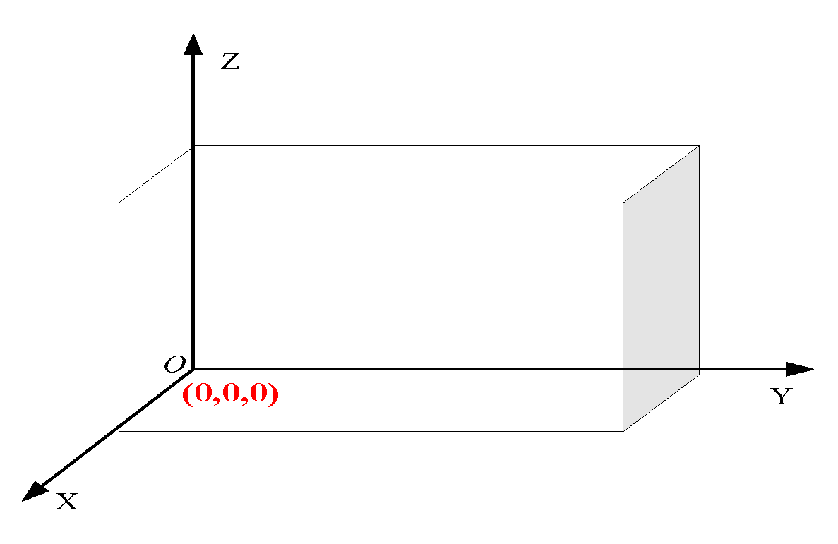
3. System Model and Problem Formulation

Currently, UAV swarms in urban environments often engage targets in a kamikaze manner, requiring the planning of an optimal flight path before takeoff. This path planning must consider the maneuverability constraints and range of the UAVs while also ensuring that the swarm can accurately avoid all tall obstacles and threat areas in the complex urban landscape. This is crucial to ensuring that the UAVs can safely and swiftly reach the target point and destroy the target, thereby maximizing their combat effectiveness.
Path planning first requires modeling the planning space, which can be expressed mathematically as a set of points { ( x , y , z ) | 0 x X , 0 y Y , 0 z Z } . It is assumed that the three-dimensional environment in which the UAV path planning task is performed is a cuboid X × Y × Z , based on which a three-dimensional Cartesian coordinate system is established with 0 = ( 0 , 0 , 0 ) as the origin. As shown in Figure 1, this paper uses a three-dimensional elevation map modeling method to model the urban environment. The three-dimensional elevation map modeling method is a technique that utilizes arrays for modeling [17]. This method not only accurately represents the terrain and topography of urban buildings as well as information on radar and other defense measures, it also highlights features such as the height, location, and size of threat zones. Therefore, the three-dimensional elevation map method is highly suitable for modeling the three-dimensional urban environment studied in this paper.

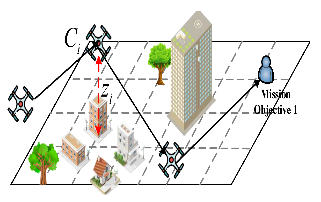
3.1. Urban Building Modeling

In complex three-dimensional planning environments, UAVs face the challenge of navigating around obstacles flexibly, with the most significant obstacles being tall buildings in a city’s skyline. To accurately simulate and optimize the UAV flight path, this paper cleverly simplifies the intricate urban building structures into a collection of cylinders. This abstraction not only retains the main constraints that buildings impose on UAV flight but also significantly reduces computational complexity [18]. This allows the UAV path planning algorithm to handle and find safe detour paths more efficiently. As shown in Figure 2, each cylindrical city building m is represented as ( a m , b m , h m , R m ) , where ( a m , b m ) represents the coordinates of the central area, h m represents the height of the building, and R m represents the radius of the building. This can be defined as shown below.
Z m ( x , y ) = h m , if ( x a m ) 2 + ( y b m ) 2 R m 2 0 , otherwise

3.2. Threat Area Modeling

In the complex and dynamic task scenarios faced by UAVs, traversing areas that are densely covered by enemy radar or encountering intense electronic interference zones are inevitable challenges. These potential ground obstacles are composed of radar systems and electromagnetic interference devices deployed on the ground. To accurately characterize the spatial distribution and impact depth of these threats, a hemispherical model is introduced as an analytical tool [19]. As shown in Figure 3, this model can realistically simulate the comprehensive coverage range and affected area of ground threats thanks to its excellent geometric representation capabilities. Each ground threat area n is represented as ( a n , b n , R n ) , where ( a n , b n ) represents the coordinates of threat area central area and R n represents the radius of the threat area, which can be defined as shown below.
Z n ( x , y ) = R n 2 ( x a n ) 2 ( y b n ) 2

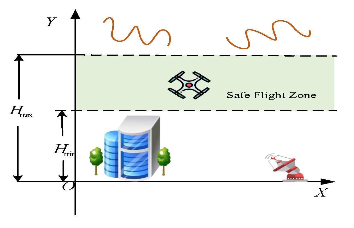
3.3. UAV Trajectory Constraints

UAV swarms face numerous constraints when conducting target strikes in urban environments. The primary constraints include flight altitude, maximum range, and waypoint obstacle avoidance.
(1) UAV safe flight altitude constraints. When executing precise target strike missions in urban environments, excessively high flight altitudes can enhance the field of view, but may also compromise stealth by increasing the risk of detection by enemy radar systems. Conversely, if the flight altitude is set too low, the UAVs may find it difficult to quickly adjust their position to avoid sudden obstacles such as tall buildings, significantly increasing the risk of collisions. Therefore, it is crucial to carefully establish reasonable maximum and minimum flight altitude thresholds. As shown in Figure 4, this ensures that UAVs maintain sufficient stealthy while also having enough maneuvering space to respond to unexpected situations, allowing them to efficiently complete the strike mission while ensuring safety.
Assuming that the current flight altitude of the UAV is h, the minimum safe flight altitude is H min and the maximum safe flight altitude is H max . Thus, the UAV’s flight altitude must be strictly controlled between H min and H max to ensure flight safety and the successful completion of the mission. This flight altitude constraint can be precisely described by the mathematical expression in Equation (3).
H m i n h H m a x
(2) UAV maximum range constraint [20]. Given the size limitations imposed by the miniaturization of UAVs, their endurance capability naturally becomes a significant bottleneck. As shown in Figure 5, in addition to basic energy consumption, during actual flight operations the complexity of maneuvering, unpredictable wind resistance, and varying environmental factors such as temperature and air pressure further increase energy consumption, significantly weakening the UAV’s endurance. To optimize the operational effectiveness of the UAV and extend its mission execution time, it is crucial to set the UAV’s range constraints reasonably. This involves establishing the maximum range limit for the UAV under given conditions, as shown in Equation (4):
i = 1 n l i l m a x
where l i represents each segment of the flight path. The UAV’s total range is composed of n flight segments, denoted as { l 1 , l 2 , l 3 , , l n } .
(3) Waypoint obstacle avoidance constraint [21]. As shown in Figure 6, when a UAV executes a flight mission, ensuring the planning of a safe flight path is crucial. This includes accurately avoiding tall buildings in the city and potential threat areas. Therefore, it is essential to strictly adhere to stringent obstacle avoidance guidelines for urban buildings when setting waypoints. This ensures that the UAV maintains a safe distance while navigating through the city, avoiding any form of collision risk. Specifically, the elevation of any waypoint C i = ( x i , y i , z i ) should be greater than the elevation of the corresponding ground terrain and urban buildings. This can be defined as shown below.
z i > Z ( x i , y i )

3.4. UAV Trajectory Cost Function

(1) Range cost [22]. In the complex task of UAV trajectory planning, the range cost is considered a crucial decision dimension. It is closely related to the UAV’s flight duration, energy utilization efficiency, and overall mission performance. Optimization strategies often focus on minimizing the flight distance between the current waypoint and the next carefully planned feasible waypoint. Given a waypoint C i and another waypoint C i 1 in the feasible domain A i 1 , the range cost D i can be defined as the actual flight distance from C i to C i 1 . This distance can be expressed mathematically using the Euclidean distance, as follows:
D i = ( x i x i 1 ) 2 + ( y i y i 1 ) 2 + ( z i z i 1 ) 2
where ( x i , y i , z i ) and ( x i 1 , y i 1 , z i 1 ) are the coordinates of waypoints C i and C i 1 , respectively.
(2) Altitude change cost [23]. In the process of executing flight missions, it is crucial for UAVs to maintain relatively stable flight altitudes. Therefore, the introduction of the altitude standard deviation as a quantitative metric is innovative. This metric accurately measures the cost of altitude changes in the UAV’s flight path. By calculating the standard deviation of altitude data throughout the entire flight, the stability of the UAV’s flight altitude can be assessed. This provides a scientific basis for optimizing flight strategies and reducing unnecessary altitude adjustments, as follows:
σ h = 1 n i = 1 n ( h i h ¯ ) 2
where σ h represents the standard deviation of the flight altitudes, h i represents the altitude at waypoint i, h ¯ is the mean altitude over all waypoints, and n is the total number of waypoints.
(3) Turning angle cost. In complex UAV flight tasks, reducing unnecessary frequent turns is crucial for maintaining flight stability, reducing energy consumption, and enhancing mission efficiency. To evaluate the frequency and smoothness of turns in the UAV’s flight path, the sum of the sine values of the turning angles between adjacent waypoints is used, as follows:
G = i = 1 C 1 sin arccos x i x i + 1 + y i y i + 1 + z i z i + 1 x i 2 + y i 2 + z i 2 x i + 1 2 + y i + 1 2 + z i + 1 2
where C is the total number of waypoints, while ( x i , y i , z i ) and ( x i + 1 , y i + 1 , z i + 1 ) are the coordinates of adjacent waypoints.
The total trajectory cost J for the UAV during a target strike should consider these three costs. Therefore, the total trajectory cost J is the sum of the travel cost D i , altitude change cost σ h , and turning angle cost G, as follows:
J = D i + σ h + G .

3.5. Cubic B-Spline Smoothing

The cubic B-spline smoothing method is used in such various fields as data processing, graphics generation, and modeling due to its excellent smoothness, local control capabilities, high precision, computational efficiency, strong adaptability, and continuity of derivatives [24]. Because the trajectories planned for UAV swarms are often piecewise linear, applying cubic B-spline smoothing can refine these trajectories to achieve smoother and more optimized paths. As shown in Figure 7, the cubic B-spline method utilizes higher-order continuity (i.e., continuity of the curve, its first derivative, and its second derivative) to achieve very smooth transitions between different control points [18]. This ensures that the curve transitions smoothly between segments, avoiding sharp angles or jagged edges. This smoothness not only makes the curve visually more natural and fluid but also prevents visual discomfort caused by sharp turns or abrupt changes.
In summary, this paper constructs a highly realistic model that accurately reflects the urban environment by precisely modeling city buildings and threat zones. The model comprehensively simulates UAV target strike missions in complex urban environments while considering practical issues such as dense city buildings and complex airspace. It also incorporates key constraints such as flight altitude limits, maximum range, and waypoint obstacle avoidance. Based on this, an innovative Electric Eel Foraging Optimization (EEFO) algorithm is proposed for planning optimal strike trajectories for UAV swarms. The EEFO algorithm combines dynamic programming, local optimization, and global search techniques to effectively generate safe and efficient paths for each UAV in complex environments. The algorithm dynamically adjusts flight paths to avoid collisions with buildings and threat zones while minimizing the total trajectory cost and reducing energy consumption, ensuring efficient task completion. Furthermore, through real-time feedback mechanisms, EEFO demonstrates strong adaptability and flexibility, optimizing decisions based on environmental changes and potential interference to achieve optimal trajectory planning for target strike missions.

4. Electric Eel Foraging Optimization Algorithm

In 2024, inspired by the foraging behavior of electric eel groups in nature, W. Zhao proposed the Electric Eel Foraging Optimization (EEFO) algorithm [25]. The EEFO algorithm draws inspiration from the intelligent group foraging behavior of electric eels in the wild, mathematically modeling the four key foraging behaviors of eels, namely, interaction, resting, hunting, and migration, to provide exploration and exploitation capabilities in the optimization process.

4.1. Algorithm Principle

The EEFO algorithm emulates the foraging behaviors of electric eels, specifically interaction, resting, hunting, and migration. During the interaction phase, electric eels use electric discharges to sense their environment and communicate with conspecifics, which translates into interactions and information exchange among search agents in the algorithm, representing a global exploration phase. In the resting phase, eels rest in designated areas, which is analogous to search agents in the algorithm temporarily remaining stationary. This approach helps to prevent excessive exploitation of local regions and premature convergence to local optima. The hunting phase is modeled as search agents pursuing and capturing potential optimal solutions, reflecting eels’ hunting behavior. During the migration phase, eels move from resting areas to hunting areas in search of new food sources, which is mirrored by the search agents’ global search within the solution space.
Interaction behavior. In EEFO, each electric eel represents a candidate solution, and the best candidate solution obtained at each step is considered as the target prey. This interaction indicates that each eel cooperates with other individuals by using the positional information of all eels in the population. An eel can interact with any randomly selected eel in the population using the positions of all individuals. The interaction among eels is characterized by “stirring”, which involves random movement in various directions. The interaction behavior can be defined as shown below.
v i ( t + 1 ) = x j ( t ) + C x ¯ ( t ) x i ( t ) p 1 > 0.5 v i ( t + 1 ) = x j ( t ) + C x r ( t ) x i ( t ) p 1 0.5 f i t x j ( t ) < f i t x i ( t )
v i ( t + 1 ) = x i ( t ) + C x ¯ ( t ) x j ( t ) p 2 > 0.5 v i ( t + 1 ) = x i ( t ) + C x r ( t ) x j ( t ) p 2 0.5 f i t x j ( t ) f i t x i ( t )
The average position and a random individual are defined as follows:
x ¯ ( t ) = 1 n i = 1 n x i ( t ) x r = L o w + r ( U p L o w )
where C is a random matrix with values of 0 or 1, p 1 and p 2 are random numbers within the interval (0, 1), fit ( x i ( t ) ) denotes the fitness of the i-th eel’s candidate position, x j represents the position of a randomly selected eel from the current population with j i , n is the population size, r is a random vector within (0, 1), and Low and Up represent the lower and upper bounds, respectively.
Resting behavior. To enhance search efficiency, a resting area is established by projecting one dimension of the eel’s position vector onto the main diagonal of the search space. Both the search space and the eel’s position are normalized to the range of 0–1. A randomly selected dimension of the eel’s position is projected onto the main diagonal of the normalized search space, and this projected position is considered the center of the eel’s resting area. This can be defined as follows:
{ X | | X Z ( t ) | α 0 | Z ( t ) x p r e y ( t ) | } α 0 = 2 e e t T
where x prey is the position vector of the best solution obtained thus far, α 0 is the initial scale of the resting area, the term α 0 × | Z ( t ) x prey ( t ) | represents the range of the resting area, x rand ( n ) ( rand ( d ) ) is the randomly selected position dimension of an individual from the current population, and Z is the normalized number.
Before performing the resting behavior, the resting position of the fish within its resting area is obtained as follows:
R i ( t + 1 ) = Z ( t ) + α Z ( t ) x p r e y ( t ) α = α 0 sin ( 2 π r 2 )
where a represents the scale of the resting area, r 2 denotes a random number within the interval (0, 1), and the scale α causes the range of the resting area to decrease as the iterations proceed. For resting behavior,
ν i ( t + 1 ) = R i ( t + 1 ) + n 2 R i ( t + 1 ) round ( rand ) x i ( t ) , n 2 N ( 0 , 1 )
where n 2 represents a random variable drawn from a normal distribution N ( 0 , 1 ) . This random disturbance n 2 introduces slight fluctuations in the eel’s position during the resting phase, helping to avoid overconcentration of the solution and promoting a more diverse search space. The function round(rand) generates a random value of either 0 or 1, which is used to randomly decide whether to incorporate the current electric eel’s position x i ( t ) . If round(rand) = 1, the current position x i ( t ) is included; otherwise, if round(rand) = 0, only the updated position R i ( t + 1 ) is considered. This can be defined as follows:
X | | X x p r e y ( t ) | β 0 | x ¯ ( t ) x p r e y ( t ) | β 0 = 2 e e t T
where β 0 is the initial scale of the hunting area; according to Equation (18), the hunting range of the eel centered on prey x pery is determined by the term β 0 × | x ¯ ( t ) x pery ( t ) | .
The prey’s position is as follows:
H p r e y ( t + 1 ) = x p r e y ( t ) + β x ¯ ( t ) x p e r y ( t ) β = β 0 sin ( 2 π r 3 )
where β is the scale of the hunting area, r 3 is a random number within the range (0, 1), and the scale β causes the range of the hunting area to decrease over time. The curling behavior exhibited by eels during the hunting process is
v i ( t + 1 ) = H p r e y ( t + 1 ) + η H p r e y ( t + 1 ) round ( rand ) x i ( t ) ,
where η is the curling factor:
η = e r 4 ( 1 t ) T cos ( 2 π r 4 )
with r 4 being a random number within the range (0, 1).
Eels can sense the position of prey through low discharges, allowing them to adjust their positions at any time. If an eel senses the proximity of prey during foraging, it will move to a candidate position; otherwise, it will remain in its current position, which can be defined as shown below.
x i ( t + 1 ) = x i ( t ) f i t ( x i ( t ) ) f i t ( ν i ( t + 1 ) ) v i ( t + 1 ) f i t ( x i ( t ) ) > f i t ( ν i ( t + 1 ) )

4.2. Algorithm Complexity

The computational complexity of heuristic optimization methods greatly affects algorithm performance, especially in large-scale or complex environments. High complexity can lead to longer execution times, limiting scalability and real-time applicability [26]. The five algorithms we tested in our experiments were the Sine Cosine Algorithm (SCA), Beluga Whale Optimization (BWO), Moth Flame Optimization (MFO), Harris Hawks Optimization (HHO), and Snake Optimizer (SO), all of which suffer from significant computational inefficiencies due to their inherent mechanisms. SCA and BWO rely on complex interactions among multiple solution candidates across various stages of the search process, leading to high computational costs. Each iteration requires extensive function evaluations to assess potential solutions, resulting in slower convergence, particularly in large-scale environments. On the other hand, MFO and HHO focus heavily on exploration during the early search phases, leading to redundant evaluations and excessive computational effort, especially in vast solution spaces. These algorithms require many iterations to adjust search directions, further increasing computation time. Although SO is relatively efficient for certain problems, it still requires multiple evaluation rounds to find optimal solutions, as it does not narrow down the search space early enough, increasing the number of function evaluations per iteration. Overall, these algorithms exhibit high computational complexity due to their reliance on multistage search interactions, excessive exploration, and numerous iterations. Moreover, their lack of efficient real-time feedback or adaptation to dynamic environments exacerbates the computational burden, making them less suited for large-scale real-time UAV swarm operations in complex environments.
In contrast, the EEFO algorithm outperforms traditional optimization methods such as SO, SCA, BWO, MFO, and HHO in large-scale complex environments due to several key features. Its efficient multilevel decision-making structure simplifies the search process at both the global and local levels, leading to faster convergence and reduced computational complexity. By dynamically adjusting strategies based on real-time feedback, EEFO refines its search directions quickly, avoiding redundant calculations and minimizing computation time. Additionally, EEFO balances exploration and exploitation through a natural foraging behavior model, ensuring efficient convergence without unnecessary search efforts. The algorithm reduces redundancy by focusing on areas that are likely to yield improvements, leading to fewer iterations and faster execution. It also integrates real-time coordination and path optimization to dynamically adjust UAV flight paths in response to environmental changes, which is crucial for large-scale complex scenarios. Furthermore, EEFO minimizes computational overhead by simplifying trajectory adjustments, avoiding the need for multiple complex calculations. These features enable EEFO to execute UAV swarm operations more efficiently, making it ideal for real-time decision-making in dynamic urban scenarios.
The EEFO algorithm also introduces an energy factor, which is used to control the transition from global search to local search and to balance exploration and exploitation. The energy factor is higher in the early stages of the algorithm, favoring global search; as the iterations proceed, the energy factor gradually decreases, prompting the algorithm to focus more on local search, thereby improving the precision of the solution. The summary of this algorithm is presented in Algorithm 1.
Algorithm 1 Electric Eel Foraging Optimization (EEFO)
Input: Starting point coordinates, building coordinates and heights, threat area coordinates, and ranges.
Output:  n 30 , T 50 Randomly generate the path X i for each eel within the feasible space, calculate the fitness fit i for each eel, and let x prey ( t ) be the optimal solution.
  1:  while the termination condition is not met do
  2:  for each eel X i  do
  3:        Calculate the energy factor E.
  4:        for each time slot t do if  E > 1  then
  5:              Update position according to interaction behavior
  6:              Calculate individual fitness
  7:               else if  rand > 1 3  then
  8:                   Calculate the resting area
  9:                   Update position according to resting behavior
10:                   Calculate individual fitness
11:               else if  rand > 2 3  then
12:                   Update position according to migration behavior
13:               else
14:                   Calculate the hunting area
15:                   Update position according to hunting behavior
16:               end if
17:        end for
18:        Update the position of each eel
19:        Update the optimal solution x prey ( t )
20:  end for
21:  eturn the optimal solution x prey ( t )
22:  end while

5. Experimental Simulation and Analysis

The simulation environment in this paper was as follows: Windows 10 64-bit, Intel Core i7-11800H processor, main frequency of 2.30 GHz, memory 64 GB, Matlab software simulation platform. The simulation parameters are shown in Table 2.
To highlight the advantages of the EEFO algorithm, the Snake Optimizer (SO) [27], Sine Cosine Algorithm (SCA) [27], Beluga Whale Optimization (BWO) [28], Moth Flame Optimization (MFO) [29], and Harris Hawk Optimization (HHO) [30] were introduced for comparison. To compare the path planning performance of the EEFO algorithm in both undefended and defended urban environments, two experimental scenarios were set up with the obstacles and threat areas shown in Table 3.

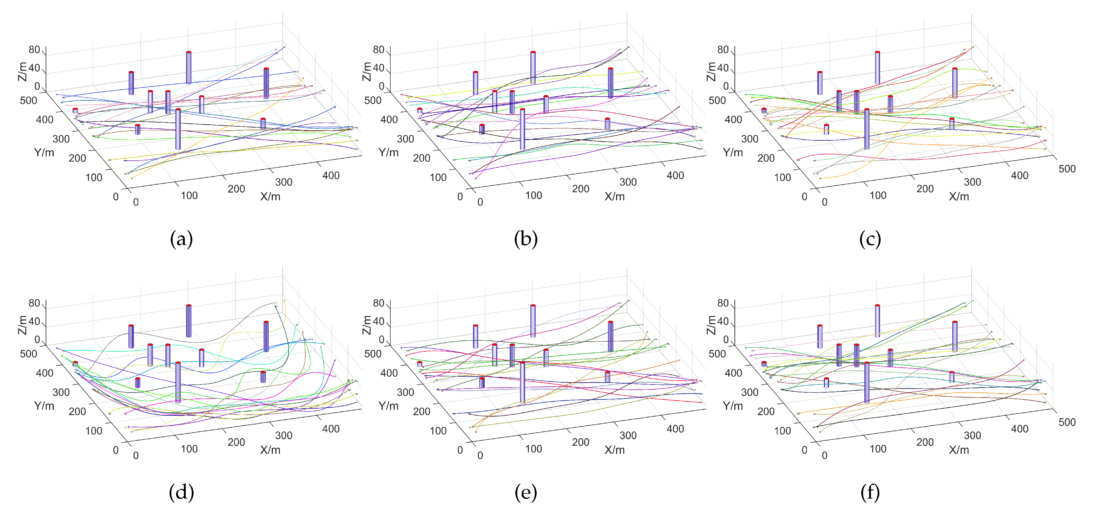
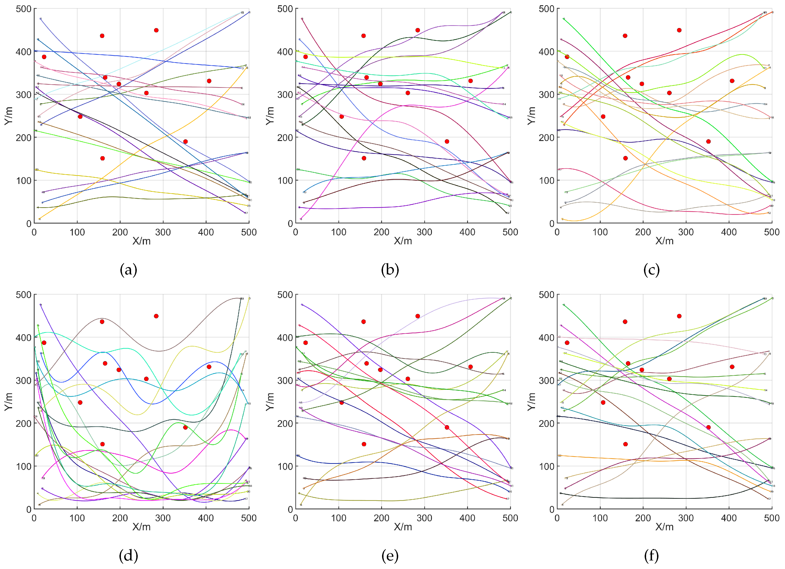
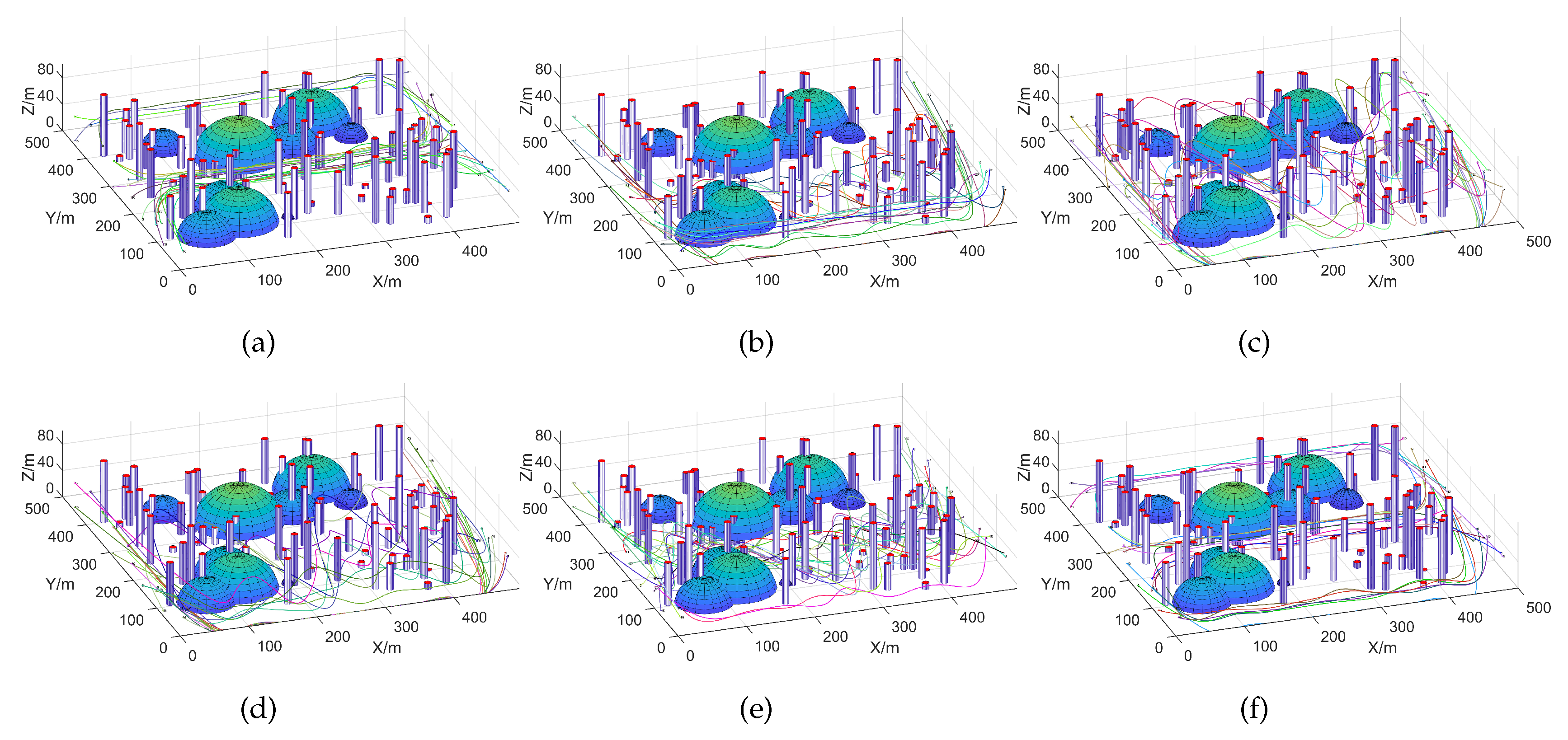
5.1. UAV Path Planning with the EEFO Algorithm in Sparse Environments Under Undefended Conditions

First, we set up a scenario consisting of sparse urban environment under undefended conditions, with the number of city buildings fixed at 10 and the number of threat areas at 0. The positions of the buildings and threat areas were randomly distributed. In this scenario, the UAV swarm consisted of 20 UAVs, each responsible for targeting one of 20 tasks. After conducting an in-depth study of the target strike trajectories of various algorithms in both 3D and 2D environments, significant differences in performance were observed. The results shown in Figure 8 and Figure 9 provide a strong basis for further analysis and comparison of the advantages and disadvantages of each algorithm.
From the results shown in Figure 8 and Figure 9, it can be observed that the EEFO, HHO, MFO, SO, SCA, and WOA algorithms all demonstrate effective planning capabilities in the undefended scenario with sparse building distribution. The algorithms successfully plan flight trajectories that avoid the sparse buildings, and the UAVs accurately reach the targets for their strike tasks. Among the different algorithms, the EEFO algorithm stands out with its particularly straight and smooth trajectories, which feature fewer turns and relatively shorter path lengths. The path planning results are able to not only cleverly avoid all obstacles to ensure safe passage for the UAV, but also show a significant advantage in trajectory length compared to the other five algorithms. This indirectly indicates that the UAV swarm will consume less energy in achieving the target strikes when using the EEFO algorithm. In contrast, the target strike trajectories planned by the other five algorithms are more curved, exhibit greater fluctuations, lack stability, and have longer path lengths with more turns. This results in more convoluted and time-consuming paths with poorer smoothness, indicating that the UAV swarm will consume more energy during target strikes when using one of the other five algorithms.
Figure 10a compares the optimal fitness values of the different algorithms in the sparse environment scenario under undefended conditions. The figure clearly demonstrates the optimal fitness values of each algorithm. The key aspect of this metric is that a lower fitness value indicates a smaller path cost. This is visually reflected in the target strike trajectory, where the planned trajectory is closer to a straight line with minimal vertical fluctuations, exhibiting higher stability. As shown in Figure 10, the SCA algorithm has a larger optimal fitness value with greater fluctuations, while the optimal fitness values of the EEFO, SO, HHO, MFO, and WOA algorithms are smaller, with fewer fluctuations and higher stability.
Figure 10b presents the average optimal fitness values for the six algorithms when completing 20 target tasks. These results provide robust data support for a comprehensive evaluation of each algorithm’s performance. In the bar chart, the height represents the average optimal fitness value for each algorithm. The bottom and top of the black bars respectively indicate the minimum and maximum optimal fitness values for each algorithm, while the scatter points illustrate the distribution of the optimal fitness values. From Figure 11, it is evident that the average optimal fitness value of the EEFO algorithm is significantly lower than that of the other five algorithms. Furthermore, the EEFO algorithm also exhibits lower minimum and maximum optimal fitness values compared to the other five algorithms.
Figure 10c further illustrates the optimal fitness values of the six algorithms in completing 20 target tasks. The figure clearly shows that the EEFO algorithm consistently achieves the lowest optimal fitness values for each target. In contrast, the SO, WOA, MFO, and HHO algorithms perform moderately, while the SCA algorithm exhibits the highest optimal fitness values for all 20 targets.
In summary, in an invincible defense environment with sparse building distribution, the EEFO algorithm demonstrates significant advantages in planning the strike trajectories for 20 targets. Specifically, the algorithm requires a lower average path cost, exhibits superior stability, and achieves higher efficiency in trajectory planning. This enables the UAVs to execute their target strikes more rapidly, significantly enhancing overall target strike efficiency and flexibility. In this comparison, the trajectories planned by the EEFO algorithm excel in multiple key metrics, including path length, stability, and path cost, outperforming the other five algorithms and showcasing superior performance.

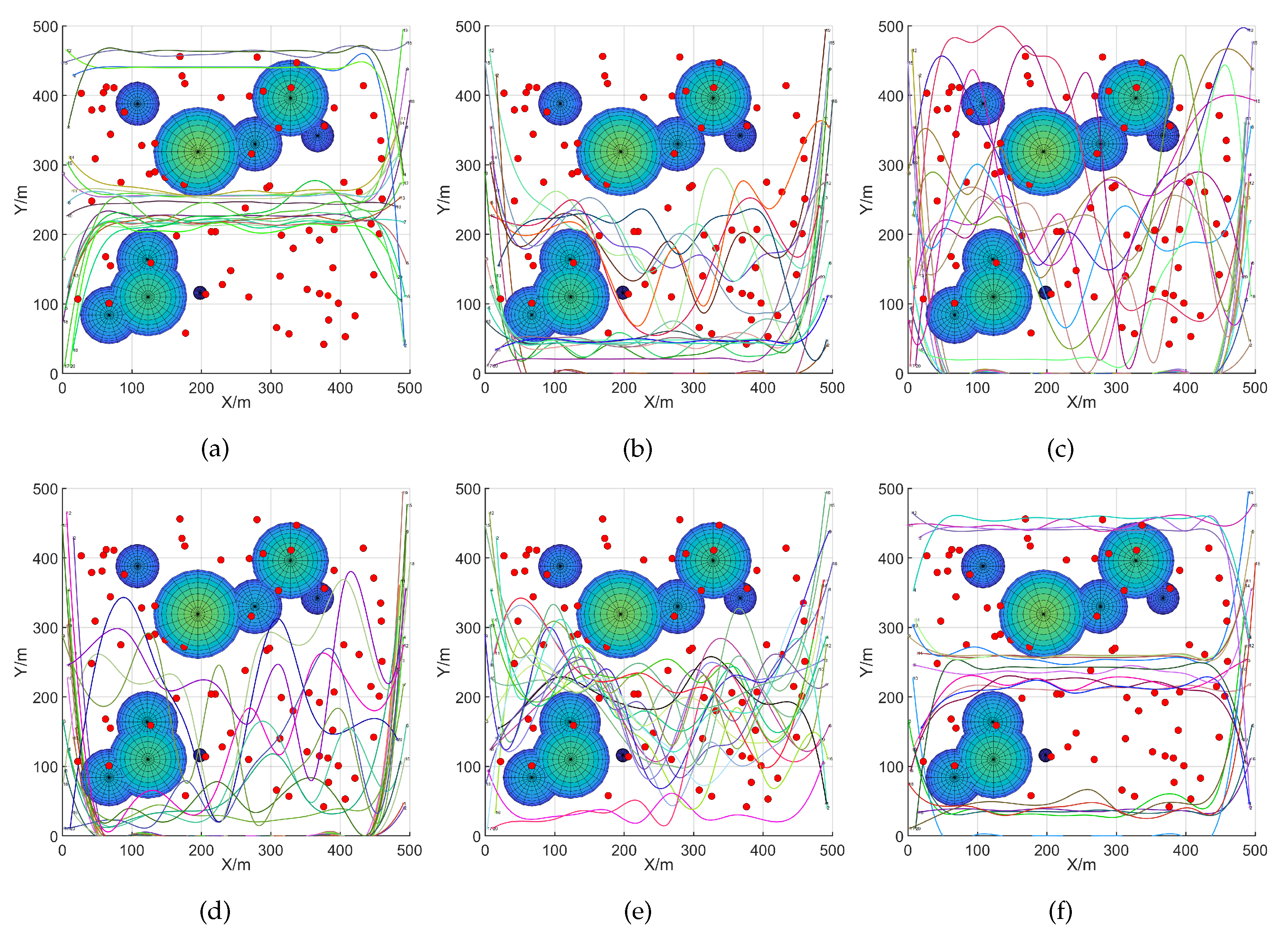
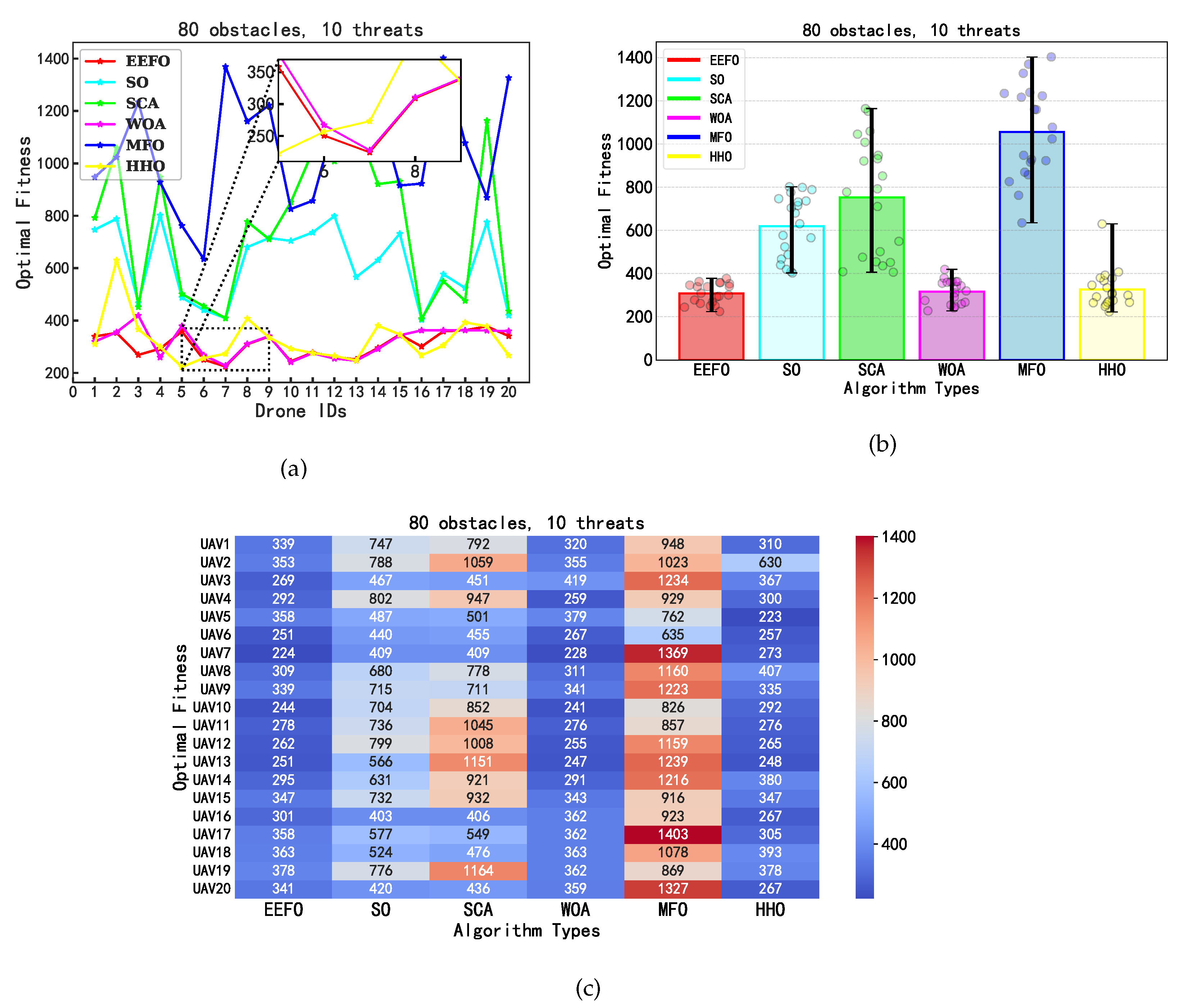
5.2. UAV Path Planning with the EEFO Algorithm in Dense Environments Under Defended Conditions

In this experiment, we set up a scenario consisting of a densely populated urban environment under enemy defense, with 80 buildings and 10 threat zones, both randomly distributed. A swarm of 20 UAVs is again deployed, with each responsible for striking a specific target, totaling 20 targets. By conducting an in-depth study of the target strike trajectories of the different algorithms in both three-dimensional and two-dimensional environments, we observed significant differences in the performance of these algorithms. As shown in Figure 11 and Figure 12, the results provide strong evidence for further analysis and comparison of the strengths and weaknesses of each algorithm.
Figure 11 and Figure 12 compare the UAV swarm target strike trajectories in the densely populated urban environment scenario under enemy defense. In this scenario, all six algorithms demonstrate the ability to plan trajectories that successfully navigate around dense buildings and threat zones, effectively guiding the UAVs to their targets. Notably, the trajectories planned by the EEFO algorithm stand out due to their straight and smooth paths with fewer turns and relatively shorter lengths. This efficient planning not only adeptly avoids obstacles and threat areas to ensure the UAVs’ safe passage, but also significantly reduces trajectory length compared to the other five algorithms. This translates to lower energy consumption for the UAV swarm when executing strike missions. In contrast, the trajectories generated by the other five algorithms are more curved and exhibit greater fluctuations, with the SCA, SO, and MFO algorithms producing longer and more winding paths. These less efficient trajectories result in longer travel times, reduced smoothness, and higher energy consumption during target strikes.
As shown in Figure 13a, presenting a comparison of the optimal fitness values of various algorithms under a densely defended environment. This figure clearly illustrates the optimal fitness values for each algorithm, where a lower fitness value indicates a smaller trajectory cost. The key insight is that a lower fitness value corresponds to trajectories that are closer to straight lines with minimal fluctuations, reflecting higher stability. Algorithms HHO, SO, SCA, and MFO exhibit higher optimal fitness values with greater fluctuations, indicating less stability. In contrast, EEFO and WOA algorithms demonstrate lower and more stable fitness values. Among these, EEFO shows a superior performance with the lowest optimal fitness value compared to WOA, indicating a more stable and efficient trajectory planning.
As shown in Figure 13b, providing a comparison of the average optimal fitness values of six algorithms when completing 20 target tasks, offering robust data for a comprehensive performance assessment. In the figure, the height of the bar charts represents the average optimal fitness value for each algorithm, while the black bars indicate the minimum and maximum values of the optimal fitness, and the scatter points illustrate the distribution of optimal fitness values for each algorithm. The EEFO and WOA algorithms exhibit significantly lower average optimal fitness values compared to the other four algorithms. Additionally, the EEFO algorithm consistently shows lower maximum optimal fitness values and a narrower range of values, indicating a more concentrated distribution and greater stability.
Figure 13c further illustrates the optimal fitness values of the six algorithms when completing 20 target tasks. The figure reveals that the EEFO algorithm consistently achieves the lowest optimal fitness values for each target among the 20 tasks. In comparison, the WOA and HHO algorithms perform somewhat better, while the SCA and SO algorithms have relatively higher optimal fitness values for each target. In contrast, the MFO algorithm shows the highest optimal fitness values overall.
In summary, the EEFO algorithm demonstrates significant advantages in planning the attack trajectories for 20 targets in the enemy-defended environment scenario with densely distributed buildings. Specifically, this algorithm requires a lower average path cost, exhibits superior stability, and achieves higher efficiency in trajectory planning. These factors enable the UAVs to execute target strikes more swiftly, significantly enhancing their overall strike efficiency and flexibility. In this comparison, the trajectories planned by the EEFO algorithm are superior in terms of length, stability, and path cost, showcasing its exceptional performance and ability to outperform the other five algorithms.

6. Conclusions

To address the issue of targeting UAV swarm strikes in complex urban environments, this paper sets up two scenarios: a sparse environment without enemy defense, and a dense environment with enemy defense. Corresponding constraints and trajectory optimization cost functions are designed for both scenarios. To efficiently achieve target strikes, this paper innovatively introduces the Electric Eel Foraging Optimization (EEFO) algorithm. This algorithm emulates the intelligent search mechanism of electric eel predation behavior in nature to plan safe and efficient flight trajectories for UAV swarms. To verify its effectiveness, the EEFO algorithm was compared with five other intelligent optimization algorithms. The experimental results indicate that the EEFO algorithm exhibits superior performance in both scenarios, outperforming the other five tested algorithms in terms of rationality and efficiency of trajectory planning as well as the convergence speed and stability of the algorithm. These results fully demonstrates the great potential and application value of the EEFO algorithm for targeting UAV swarm strike missions in complex urban environments.
In future work, our research will focus on enhancing the EEFO algorithm’s scalability and robustness to handle more dynamic and unpredictable urban environments as well as on integrating real-time data for adaptive path re-planning during UAV swarm operations.

Author Contributions

Conceptualization, C.F. and Z.L.; methodology, C.F.; software, Z.L.; validation, C.F.; formal analysis, W.J.; investigation, C.F. and Z.L.; writing, C.F.; writing, review and editing, W.J.; visualization, C.F. and Z.L.; supervision, W.J.; funding acquisition, W.J. All authors have read and agreed to the published version of the manuscript.

Funding

This work was supported in part by the National Natural Science Foundation of China under Grant 62401070 and in part by the Fundamental Research Funds for the Central Universities under Grant 2023RC16.

Data Availability Statement

Data are contained within the article.

Acknowledgments

The authors would like to thank the anonymous reviewers for their valuable comments.

Conflicts of Interest

The authors declare no conflicts of interest.

References

  1. Nwaogu, J.M.; Yang, Y.; Chan, A.P.; Chi, H.l. Application of drones in the architecture, engineering, and construction (AEC) industry. Autom. Constr. 2023, 150, 104827. [Google Scholar] [CrossRef]
  2. Mei, X.; Miao, F.; Wang, W.; Wu, H.; Han, B.; Wu, Z.; Chen, X.; Xian, J.; Zhang, Y.; Zang, Y. Enhanced Target Localization in the Internet of Underwater Things through Quantum-Behaved Metaheuristic Optimization with Multi-Strategy Integration. J. Mar. Sci. Eng. 2024, 12, 1024. [Google Scholar] [CrossRef]
  3. Miao, F.; Li, H.; Yan, G.; Mei, X.; Wu, Z.; Zhao, W.; Liu, T.; Zhang, H. Optimizing UAV Path Planning in Maritime Emergency Transportation: A Novel Multi-Strategy White Shark Optimizer. J. Mar. Sci. Eng. 2024, 12, 1207. [Google Scholar] [CrossRef]
  4. Franke, F.; Schwab, M.; Burger, U.; Hühne, C. An analytical model to determine the impact force of drone strikes. CEAS Aeronaut. J. 2022, 13, 69–84. [Google Scholar] [CrossRef]
  5. Mei, X.; Han, D.; Saeed, N.; Wu, H.; Han, B.; Li, K.C. Localization in underwater Acoustic IoT networks: Dealing with perturbed anchors and stratification. IEEE Internet Things J. 2024, 11, 17757–17769. [Google Scholar] [CrossRef]
  6. Mei, X.; Han, D.; Saeed, N.; Wu, H.; Ma, T.; Xian, J. Range difference-based target localization under stratification effect and NLOS bias in UWSNs. IEEE Wirel. Commun. Lett. 2022, 11, 2080–2084. [Google Scholar] [CrossRef]
  7. Beloev, I.H. A review on current and emerging application possibilities for unmanned aerial vehicles. Acta Technol. Agric. 2016, 19, 70–76. [Google Scholar] [CrossRef]
  8. Peng, Q.; Wu, H.; Xue, R. Review of dynamic task allocation methods for UAV swarms oriented to ground targets. Complex Syst. Model. Simul. 2021, 1, 163–175. [Google Scholar] [CrossRef]
  9. Xia, Z.; Du, J.; Wang, J.; Jiang, C.; Ren, Y.; Li, G.; Han, Z. Multi-agent reinforcement learning aided intelligent UAV swarm for target tracking. IEEE Trans. Veh. Technol. 2021, 71, 931–945. [Google Scholar] [CrossRef]
  10. Deng, H.; Huang, J.; Liu, Q.; Zhao, T.; Zhou, C.; Gao, J. A distributed collaborative allocation method of reconnaissance and strike tasks for heterogeneous UAVs. Drones 2023, 7, 138. [Google Scholar] [CrossRef]
  11. Mei, X.; Han, D.; Chen, Y.; Wu, H.; Ma, T. Target localization using information fusion in WSNs-based Marine search and rescue. Alex. Eng. J. 2023, 68, 227–238. [Google Scholar] [CrossRef]
  12. Kouroshnezhad, S.; Peiravi, A.; Haghighi, M.S.; Jolfaei, A. Energy-efficient drone trajectory planning for the localization of 6G-enabled IoT devices. IEEE Internet Things J. 2020, 8, 5202–5210. [Google Scholar] [CrossRef]
  13. Lu, Z.; Jia, Z.; Wu, Q.; Han, Z. Joint Trajectory Planning and Communication Design for Multiple UAVs in Intelligent Collaborative Air-Ground Communication Systems. IEEE Internet Things J. 2024, 11, 31053–31067. [Google Scholar] [CrossRef]
  14. Lu, Z.; Wu, G.; Zhou, F.; Wu, Q. Intelligently Joint Task Assignment and Trajectory Planning for UAV Cluster with Limited Communication. IEEE Trans. Veh. Technol. 2024, 73, 13122–13137. [Google Scholar] [CrossRef]
  15. Rabta, B.; Wankmüller, C.; Reiner, G. A drone fleet model for last-mile distribution in disaster relief operations. Int. J. Disaster Risk Reduct. 2018, 28, 107–112. [Google Scholar] [CrossRef]
  16. Muñoz, J.; López, B.; Quevedo, F.; Monje, C.A.; Garrido, S.; Moreno, L.E. Multi UAV coverage path planning in urban environments. Sensors 2021, 21, 7365. [Google Scholar] [CrossRef]
  17. Wu, J.; Wang, H.; Li, N.; Yao, P.; Huang, Y.; Yang, H. Path planning for solar-powered UAV in urban environment. Neurocomputing 2018, 275, 2055–2065. [Google Scholar] [CrossRef]
  18. Hu, X.; Pang, B.; Dai, F.; Low, K.H. Risk assessment model for UAV cost-effective path planning in urban environments. IEEE Access 2020, 8, 150162–150173. [Google Scholar] [CrossRef]
  19. Lin, Y.; Saripalli, S. Sampling-based path planning for UAV collision avoidance. IEEE Trans. Intell. Transp. Syst. 2017, 18, 3179–3192. [Google Scholar] [CrossRef]
  20. Wang, X.; Gursoy, M.C.; Erpek, T.; Sagduyu, Y.E. Learning-based UAV path planning for data collection with integrated collision avoidance. IEEE Internet Things J. 2022, 9, 16663–16676. [Google Scholar] [CrossRef]
  21. Alzakari, S.A.; Izci, D.; Ekinci, S.; Alhussan, A.A.; Hashim, F.A. A new control scheme for temperature adjustment of electric furnaces using a novel modified electric eel foraging optimizer. AIMS Math. 2024, 9, 13410–13438. [Google Scholar] [CrossRef]
  22. Linh, N.T.; Phong, D.H.T. Optimize power generation of thermal generating sources in solving the green energies-based economic load dispatch using Electric Eel Foraging Optimization. World J. Adv. Eng. Technol. Sci. 2024, 11, 368–378. [Google Scholar]
  23. Heidari, A.A.; Mirjalili, S.; Faris, H.; Aljarah, I.; Mafarja, M.; Chen, H. Harris hawks optimization: Algorithm and applications. Future Gener. Comput. Syst. 2019, 97, 849–872. [Google Scholar] [CrossRef]
  24. Seyala, N.; Abdullah, S.N. Cluster analysis on longitudinal data of patients with kidney dialysis using a smoothing cubic B-spline model. Int. J. Math. Stat. Comput. Sci. 2024, 2, 85–95. [Google Scholar] [CrossRef]
  25. Zhao, W.; Wang, L.; Zhang, Z.; Fan, H.; Zhang, J.; Mirjalili, S.; Khodadadi, N.; Cao, Q. Electric eel foraging optimization: A new bio-inspired optimizer for engineering applications. Expert Syst. Appl. 2024, 238, 122200. [Google Scholar] [CrossRef]
  26. Javanmardi, S.; Sakellari, G.; Shojafar, M.; Caruso, A. Why it does not work? Metaheuristic task allocation approaches in Fog-enabled Internet of Drones. Simul. Model. Pract. Theory 2024, 133, 102913. [Google Scholar] [CrossRef]
  27. Hashim, F.A.; Hussien, A.G. Snake Optimizer: A novel meta-heuristic optimization algorithm. Knowl.-Based Syst. 2022, 242, 108320. [Google Scholar] [CrossRef]
  28. Zhong, C.; Li, G.; Meng, Z. Beluga whale optimization: A novel nature-inspired metaheuristic algorithm. Knowl.-Based Syst. 2022, 251, 109215. [Google Scholar] [CrossRef]
  29. Zamani, H.; Nadimi-Shahraki, M.H.; Mirjalili, S.; Soleimanian Gharehchopogh, F.; Oliva, D. A critical review of moth-flame optimization algorithm and its variants: Structural reviewing, performance evaluation, and statistical analysis. Arch. Comput. Methods Eng. 2024, 31, 2177–2225. [Google Scholar] [CrossRef]
  30. Sahoo, S.K.; Saha, A.K.; Ezugwu, A.E.; Agushaka, J.O.; Abuhaija, B.; Alsoud, A.R.; Abualigah, L. Moth flame optimization: Theory, modifications, hybridizations, and applications. Arch. Comput. Methods Eng. 2023, 30, 391–426. [Google Scholar] [CrossRef]
Figure 1. Three-dimensional configuration space.
Drones 08 00777 g001
Figure 2. Schematic diagram of an urban building.
Drones 08 00777 g002
Figure 3. Schematic diagram of ground threats.
Drones 08 00777 g003
Figure 4. Flight altitude constraint.
Drones 08 00777 g004
Figure 5. Maximum range constraint.
Drones 08 00777 g005
Figure 6. Waypoint obstacle avoidance constraint.
Drones 08 00777 g006
Figure 7. Cubic B-spline smoothing curve.
Drones 08 00777 g007
Figure 8. Charts comparing the UAV swarm target strike results in the sparse environment scenario with hostile defense: (af) respectively represent the target strike trajectories of the EEFO, HHO, MFO, SCA, SO, and WOA algorithms in the 3D environment.
Drones 08 00777 g008
Figure 9. Charts comparing the UAV swarm target strike results in the sparse environment scenario with hostile defense: (af) respectively represent the target strike trajectories of the EEFO, HHO, MFO, SCA, SO, and WOA algorithms in the 2D environments.
Drones 08 00777 g009
Figure 10. Comparison of UAV swarm target strike results in the sparse environment scenario with invincible defense: (a) line chart comparing the optimal fitness values; (b) distribution chart, with bars showing differences in the optimal fitness values; (c) heatmap comparing the optimal fitness values.
Drones 08 00777 g010
Figure 11. Charts comparing the UAV swarm target strike results in the dense environment scenario with hostile defense: (af) respectively represent the target strike trajectories of the EEFO, HHO, MFO, SCA, SO, and WOA algorithms in the 3D environment.
Drones 08 00777 g011
Figure 12. Comparison of UAV swarm target strike results in the dense environment scenario with hostile defense: (af) respectively represent the target strike trajectories of the EEFO, HHO, MFO, SCA, SO, and WOA algorithms in the 2D environments.
Drones 08 00777 g012
Figure 13. Comparison of UAV swarm target strike results in the sparse environment scenario with hostile defense: (a) line chart comparing optimal fitness values; (b) distribution chart with bars representing the difference in optimal fitness values; (c) heatmap chart comparing the optimal fitness values.
Drones 08 00777 g013
Table 1. Performance comparison of algorithms.
AlgorithmPerformance
Adaptive Path Re-Planning (APREP)Limited response to sudden threats or extreme weather.
Insufficient robustness in unpredictable environments.
Multi-Objective Hybrid Path Planning (MOHPP)Computationally intensive with large UAV swarms or obstacles.
Challenges with real-time responsiveness.
Risk-Aware Path PlanningRelies on accurate, up-to-date environmental data, which may not always be available.
Limited effectiveness in dynamic urban environments with rapidly changing conditions.
Collaborative Obstacle AvoidanceFocuses on narrow passage environments, less suited for complex, three-dimensional urban settings.
Uncertain effectiveness in large-scale, dynamic urban environments.
Electric Eel Foraging Optimization Algorithm (EEFO)Simulates electric eel behavior to improve UAV adaptability and swarm coordination in complex, dynamic environments.
Adjusts planning and strategies dynamically based on real-time feedback, optimizing target recognition and obstacle avoidance.
Optimizes strike paths and enhances targeting accuracy through adaptive planning and coordination.
Table 2. Simulation parameter settings.
Parameter NameUnitSimulation Value
Planning space sizem500 × 500
Starting point positionm(20, 10, 20)
Target point positionm(410, 380, 30)
Population size-30
Maximum flight range constraintm100, 0
UAV flight height constraintm(0, 50)
Flight cost weight-0.4
Height change cost weight-0.4
Turning angle change weight-0.2
Number of iterations-50
Table 3. Simulation scenario setup.
   Scene Name    Number of Buildings Number of Threat Areas
Invincible Defense100
Hostile Defense8010
Disclaimer/Publisher’s Note: The statements, opinions and data contained in all publications are solely those of the individual author(s) and contributor(s) and not of MDPI and/or the editor(s). MDPI and/or the editor(s) disclaim responsibility for any injury to people or property resulting from any ideas, methods, instructions or products referred to in the content.

