
Digitalization and Spatial Documentation of Post-Earthquake Temporary Housing in Central Italy: An Integrated Geomatic Approach Involving UAV and a GIS-Based System

 , , ,
, , ,  and
and 
Abstract
1. Introduction
Post-Emergency Temporariness in the Italian Context
- Lack of updating of public cartography databases.
- 2.
- Lack of temporary data availability from a systemic perspective.
- 3.
- Lack of integration and interoperability procedures.
- 4.
- Lack of adequate or detailed representation scale information.
- 5.
- Lack of three-dimensional representation.
2. Related Works
Geomatics and Cartography’s Role in the Post-Disaster
- To enhance the existing national geospatial standards by integrating new fields related to emergency entities and developing a specific codification system with new concepts, attributes, and relationships to improve the current cartography.
- To integrate different emergency databases with geomatic techniques to create an Atlas tool for mapping temporary housing entities at various scales of representation, from territorial to settlement scales.
- To extract digital surface/terrain models (DSM/DTM) to understand the actual orographic modifications of temporary settlements and develop a realistic three-dimensional model (2.5D).
- To use GIS applications to organise, support, and create harmonised spatial documentation of temporary solutions.
3. Materials and Methods
3.1. Materials and Cartography Gaps
Cartographic Gaps and Material Retrieval Difficulties
3.2. Atlas of Temporary Architectures: Spatial Data Integration and Documentation Tool for Mapping the Post-Emergency Recovery Phase in Post-Disaster
- Classification of six typologies of temporary post-earthquake architecture divided into residential and non-residential categories, related to the emergency regulatory documentation.
- Definition of geometric features (point, linear, areal, or multi-polygon) and level of representation (2D/3D) at three different scales of representation (topographical, urban, and settlement).
- Definition of geometric features extracted by UAV survey following selected official technical cartographic specifications
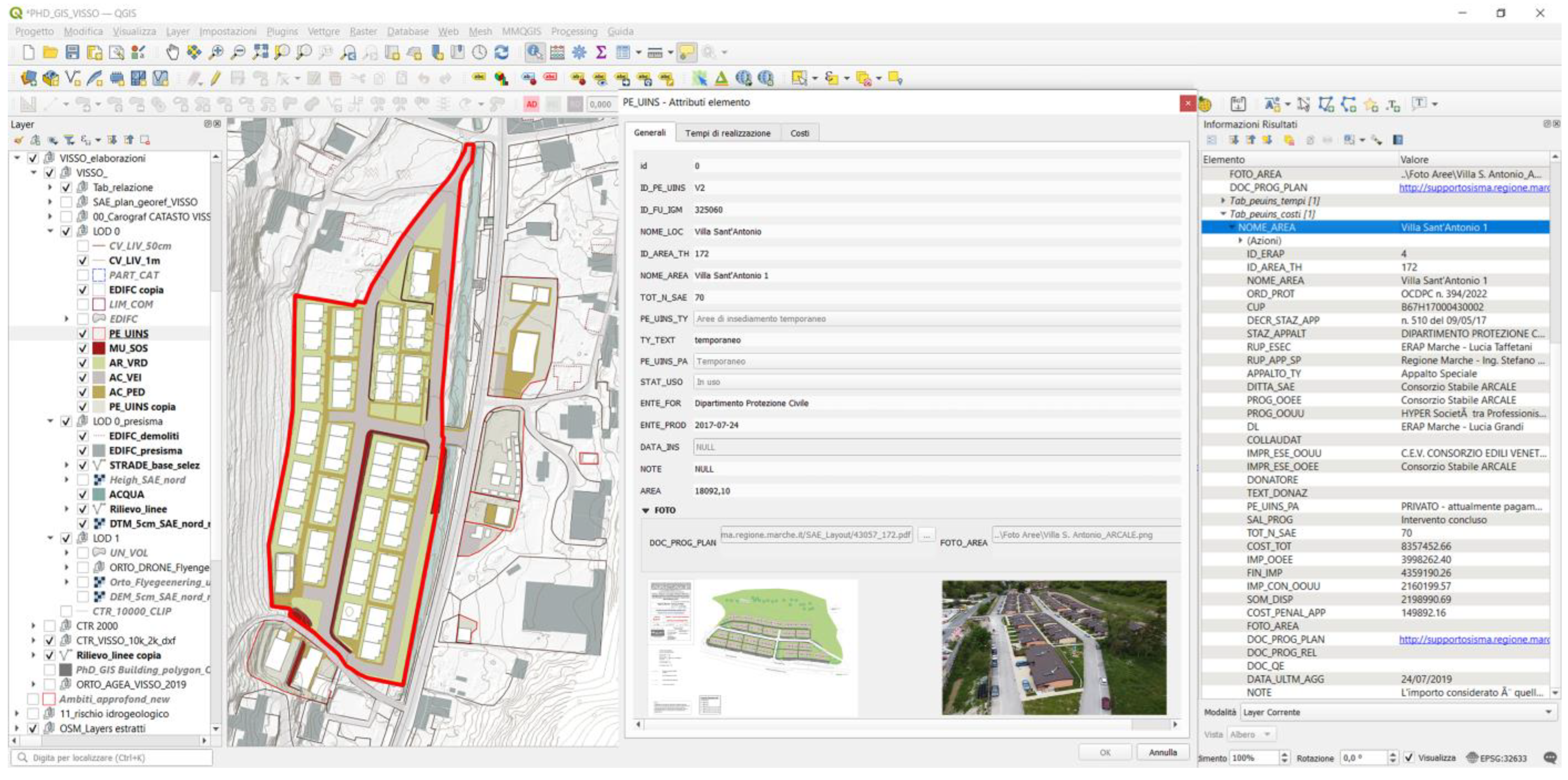
- Definition of the non-geometric attribute structure (media, design documentations, alphanumeric, and hypertextual) connected to the single entities to harmonise and implement the existing cartography
- base data available in the four-earthquake region (e.g., structured existing spatial cartographic dataset, national and regional geoportals, thematic risk data, open-source data, and satellite data)
- emergency/disaster data includes institutional databases on the topic, data from specific research projects, volunteered geographic information (VGI), and non-spatial information (e.g., spatial maps, documentation, and regulations).
3.2.1. Data Collection and Semantic Analysis for Information Extraction
- Analysis of the attributes of the Standards of Geographic Information data specifications currently in use in Europe (INSPIRE, CityGML) and in Italy (DataBase GeoTopografico (DBGT)) to select the entities and the levels of the detail representation (Lod0–Lod2) for the representation of homogeneous data in GIS environment.
- Conceptualisation of the semantic structures of databases and documents concerning the temporary post-earthquake response (DPCN database, specific regional or research project).
- Comparison of conceptual models, identification of entities to be harmonised, definition of key terms as attributes, and specific enumeration to be integrated into the standards.
- Definition of the spatial components, geometry, and attributes to be implemented to visualise the temporary spatial information and to structure the Atlas.
3.2.2. Conceptual Model and Data Harmonisation of Temporary Information
- A selection of geometric and raster objects/entities is deemed useful for documenting temporary settlements (from national DBGT, European INSPIRE, and CityGML standards).
- The inclusion of a specific enumeration for classifying temporary dwellings (Figure 5), allows for the implementation of attributes related to the conditions of use, category of use, or typology information for the building and settlement units features.
- Systematisation and relationship with external attributes (such as textual, tabular, alphanumeric, project annexes, photographic documentation), further enhance the transparency and comparability of information regarding the construction of temporary housing. These additions aid in identifying actors involved in the process, provide details on costs and intervention timelines, and explain building management. (from DPCN documents and platforms, other regional open data, from platforms and official reconstruction documents).
4. Results
4.1. Visso, Small Mountain Village as an Application Case Study
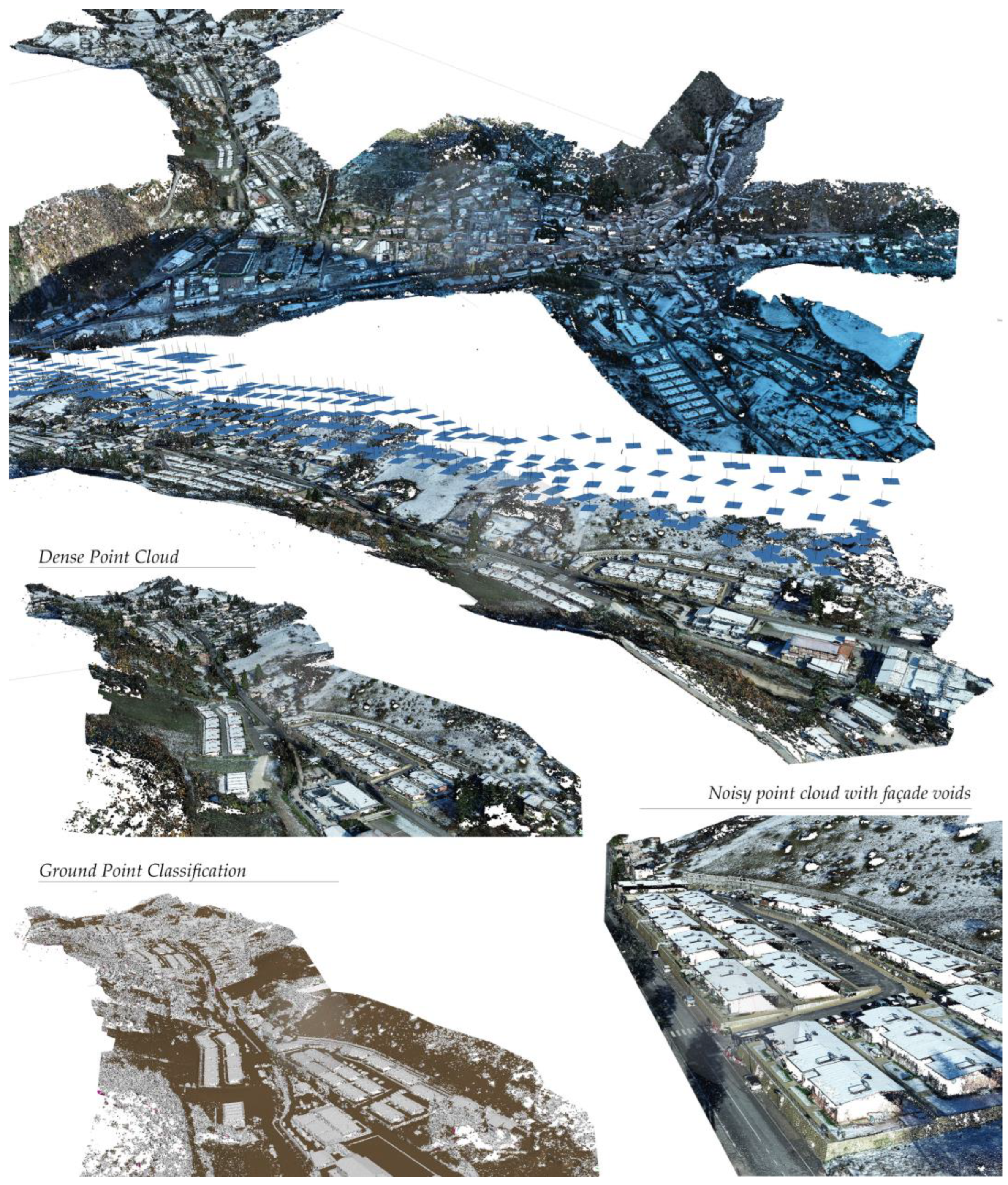
4.2. Data Acquisition: 3D Survey, Digital Photogrammetry, and UAV Data Integration
4.3. Data Processing and Point Cloud Segmentation
- UAV photogrammetric data processing to generate orthophotos, DSMs, and DTMs.
- Selection of temporary categories from the Atlas conceptual model (Section 3.2.2) for application in the Visso case study.
- Manual digitalization of temporary features for all spatial entities at the settlement scale, based on the processed orthophotos and following the conceptual model.
- Definition of contour lines and extraction of morpho-orographic sections for the temporary settlements.
- Construction of the three-dimensional model to extraction of height information of building and retaining walls.
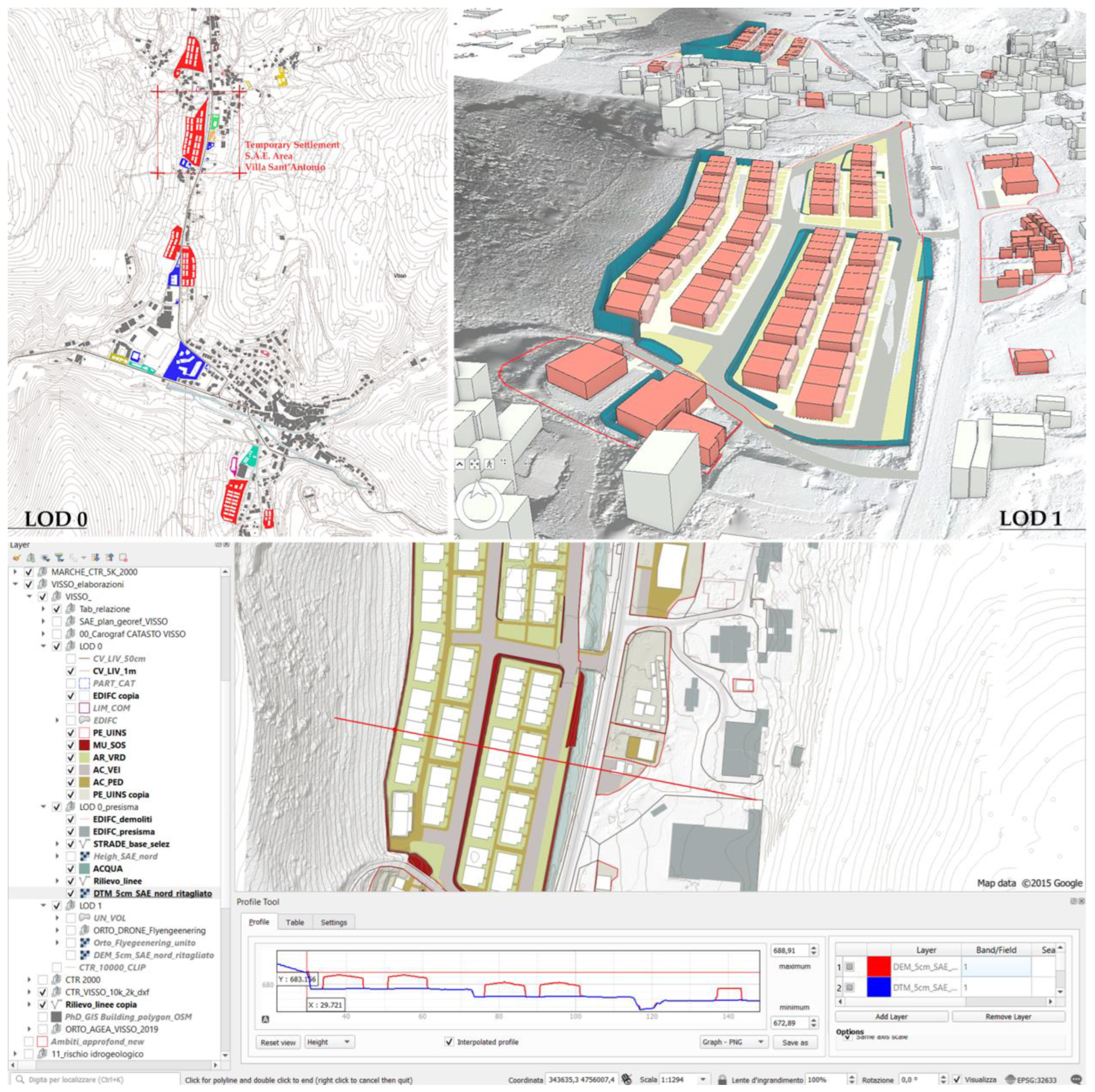
4.4. From Data to Spatial Digitalisation Using GIS System
- Territorial/Topographical scale (1:25,000/1:10,000) represents temporary features in a punctual format and with different categorisation. The research compares high-resolution orthophotos (20 cm/pix or 5 cm/pix if available) with the national cadastral map.
- Urban scale of the temporary city (1:5000/1:2000) identifies relevant perimeters and building footprints for all temporary settlements.
- Settlement and individual city objects (1:1000/1:500) manual redrawing of spatial entities (buildings, settlement unit, roads, retaining walls and other related elements, green areas, and contour lines) for the eight S.A.E. temporary areas and other bordering architecture, following the conceptual and logical model.
5. Discussion and Conclusions
Author Contributions
Funding
Data Availability Statement
Acknowledgments
Conflicts of Interest
References
- World Bank; United Nations. Natural Hazards, UnNatural Disasters: The Economics of Effective Prevention; World Bank: Washington, DC, USA, 2010. [Google Scholar]
- Perrucci, D.; Baroud, H. A Review of Temporary Housing Management Modeling: Trends in Design Strategies, Optimization Models, and Decision-Making Methods. Sustainability 2020, 12, 10388. [Google Scholar] [CrossRef]
- EM-DAT EM-DAT|The International Disasters Database. Available online: https://www.emdat.be/ (accessed on 18 March 2023).
- Wahba, S.; Triveno, L.; Terraza, H.C.; Antos, S.E. Building Better before the next Disaster: How Retrofitting Homes Can Save Lives and Strengthen Economies. Available online: https://blogs.worldbank.org/sustainablecities/building-better-next-disaster-how-retrofitting-homes-can-save-lives-and-strengthen-economies (accessed on 18 March 2023).
- Alexander, D. Principles of Emergency Planning and Management, 1st ed.; Oxford University Press: New York, NY, USA, 2002; ISBN 978-0-19-521838-1. [Google Scholar]
- Yi, H.; Yang, J. Research Trends of Post Disaster Reconstruction: The Past and the Future. Habitat Int. 2014, 42, 21–29. [Google Scholar] [CrossRef]
- Pezzica, C.; Cutini, V.; Bleil de Souza, C. Mind the Gap: State of the Art on Decision-Making Related to Post-Disaster Housing Assistance. Int. J. Disaster Risk Reduct. 2021, 53, 101975. [Google Scholar] [CrossRef]
- Pezzica, C.; Cutini, V. Linking Space Syntax and Cluster Analysis to Design and Plan Temporary Housing Neighborhoods: A Taxonomy of Sites in Norcia. J. Des. Resil. Archit. Plan. 2021, 2, 89–114. [Google Scholar] [CrossRef]
- Félix, D.; Branco, J.M.; Feio, A. Temporary Housing after Disasters: A State of the Art Survey. Habitat Int. 2013, 40, 136–141. [Google Scholar] [CrossRef]
- Wagemann, E. Need for Adaptation: Transformation of Temporary Houses. Disasters 2017, 41, 828–851. [Google Scholar] [CrossRef]
- Bologna, R. Operational Dimension of Post-Disaster Housing Temporality and Technical Control Tools. TECHNE-J. Technol. Archit. Environ. 2020, 29, 213–221. [Google Scholar] [CrossRef]
- Mela, A.; Mugnano, S.; Olori, D. (Eds.) Territori Vulnerabili: Verso una Nuova Sociologia dei Disastri Italiana; Angeli: Milano, Italy, 2017; ISBN 978-88-917-4478-4. [Google Scholar]
- Johnson, L.A.; Olshansky, R.B. After Great Disasters: How Six Countries Managed Community Recovery; Lincoln Institute of Land Policy: Cambridge, MA, USA, 2016; p. 376. ISBN 978-1-55844-338-9. [Google Scholar]
- Pezzica, C.; Cutini, V.; Bleil De Souza, C.; Aloini, D. The Making of Cities after Disasters: Strategic Planning and the Central Italy Temporary Housing Process. Cities 2022, 131, 104053. [Google Scholar] [CrossRef]
- Hosseini, S.M.A.; de la Fuente, A.; Pons, O. Multicriteria Decision-Making Method for Sustainable Site Location of Post-Disaster Temporary Housing in Urban Areas. J. Constr. Eng. Manag. 2016, 142, 04016036. [Google Scholar] [CrossRef]
- Pezzica, C.; de Souza, C.B.; Dunichkin, I.V. Developing Functional Requirements for Temporary Housing by Integrating Axiomatic Design with the 5 Gaps Model of Service Quality. IOP Conf. Ser. Mater. Sci. Eng. 2021, 1174, 012014. [Google Scholar] [CrossRef]
- Patel, S.; Hastak, M. A Framework to Construct Post-disaster Housing. Int. J. Disaster Resil. Built Environ. 2013, 4, 95–114. [Google Scholar] [CrossRef]
- Formisano, A.; Chieffo, N. Seismic Damage Scenarios Induced by Site Effects of Masonry Clustered Buildings: A South Italy Case Study. In Proceedings of the 12th International Conference on Structural Analysis of Historical Constructions (SAHC), Online event, 29 September–1 October 2021. Vulnerability and Risk Analysis. [Google Scholar] [CrossRef]
- Piccinini, F.; Gorreja, A.; Di Stefano, F.; Pierdicca, R.; Sanchez Aparicio, L.J.; Malinverni, E.S. Preservation of Villages in Central Italy: Geomatic Techniques’ Integration and GIS Strategies for the Post-Earthquake Assessment. ISPRS Int. J. Geo-Inf. 2022, 11, 291. [Google Scholar] [CrossRef]
- Perrucci, D.V.; Baroud, H. Temporary Housing Operations: A Simulation-Based Inventory Management Approach Using the Newsvendor Model. Int. J. Disaster Risk Reduct. 2021, 65, 102512. [Google Scholar] [CrossRef]
- Oggioni, C.; Chelleri, L.; Forino, G. Challenges and Opportunities for Pre-Disaster Strategic Planning in Post-Disaster Temporary Housing Provision. Evidence from Earthquakes in Central Italy (2016–2017). Ital. J. Plan. Pract. 2019, 9, 96–129. [Google Scholar]
- Quarantelli, E.L. Patterns of Sheltering and Housing in US Disasters. Disaster Prev. Manag. Int. J. 1995, 4, 43–53. [Google Scholar] [CrossRef]
- Félix, D.; Monteiro, D.; Feio, A. Estimating the Needs for Temporary Accommodation Units to Improve Pre-Disaster Urban Planning in Seismic Risk Cities. Sustain. Cities Soc. 2020, 61, 102276. [Google Scholar] [CrossRef]
- Quarantelli, E.L. Sheltering And Housing after Major Community Disasters: Case Studies and General Observations; Ohio State Univ Research Foundation Columbus: Columbus, OH, USA, 1982. [Google Scholar]
- Bashawri, A.; Garrity, S.; Moodley, K. An Overview of the Design of Disaster Relief Shelters. Procedia Econ. Financ. 2014, 18, 924–931. [Google Scholar] [CrossRef]
- Guidoboni, E.; Valensise, G. Atlante. L’azzardo Sismico Delle Città. Il Sud; Fondazione CNI: Roma, Italy, 2022; ISBN 88-6014-092-7. [Google Scholar]
- Chioni, C.; Pezzica, C.; Cutini, V.; Bleil de Souza, C.; Rusci, S. Multiscale Configurational Approach to the Design of Public Open Spaces after Urban Disasters. In Formal Methods in Architecture; Eloy, S., Leite Viana, D., Morais, F., Vieira Vaz, J., Eds.; Springer International Publishing: Cham, Switzerland, 2021; pp. 171–183. [Google Scholar]
- Pezzica, C.; Cutini, V. When time matters: Mid-term housing provision after disasters. In Proceedings of the IV International Congress on Sustainable Collective Housing, Alghero, Italy, 19–23 October 2020; pp. 264–269. [Google Scholar]
- Guidoboni, E.; Valensise, G. Il Peso Economico e Sociale Dei Disastri Sismici in Italia Negli Ultimi 150 Anni, 1861-2011, 1st ed.; Una storia fuori dai manuali/Centro euro-mediterraneo di documentazione Eventi estremi e disastri; Bononia University Press: Bologna, Italy, 2011; ISBN 978-88-7395-683-9. [Google Scholar]
- Rotondo, F.; Marinelli, G.; Domenella, L. Shrinking Phenomena in Italian Inner Mountainous Areas. Resilience Strategies. In Computational Science and Its Applications–ICCSA 2020; Gervasi, O., Murgante, B., Misra, S., Garau, C., Blečić, I., Taniar, D., Apduhan, B.O., Rocha, A.M.A.C., Tarantino, E., Torre, C.M., et al., Eds.; Lecture Notes in Computer Science; Springer International Publishing: Cham, Switzerland, 2020; Volume 12253, pp. 195–206. ISBN 978-3-030-58813-7. [Google Scholar]
- Pezzica, C.; Chioni, C.; Cutini, V.; Bleil De Souza, C. Assessing the Impact of Temporary Housing Sites on Urban Socio-Spatial Performance: The Case of the Central Italy Earthquake; Gervasi, O., Nurgante, B., Misra, S., Garau, C., Blečić, I., Taniar, D., Apduhan, B.O., Rocha, A.M.A.C., Tarantino, E., Torre, C.M., Eds.; Springer: Cham, Switzerland; Cagliari, Italy, 29 September 2020; pp. 324–339. Available online: https://link.springer.com/chapter/10.1007/978-3-030-58808-3_24 (accessed on 26 April 2023).
- Caramaschi, S.; Coppola, A. Post-Disaster Ruins: In The New Urban Ruins; O’Callaghan, C., Di Feliciantonio, C., Eds.; Vacancy, Urban Politics and International Experiments in the Post-Crisis City; Bristol University Press: Bristol, UK, 2021; pp. 125–144. ISBN 978-1-4473-5687-5. [Google Scholar]
- ISTAT. Caratteristiche Dei Territori Colpiti Dal Sisma Del 24 Agosto, 26 Ottobre e 30 Ottobre 2016 e 18 Gennaio 2017. Available online: https://www.istat.it/it/archivio/199364 (accessed on 26 April 2023).
- ISTAT. Mappa Dei Rischi Dei Comuni Italiani: Cartografia. Available online: https://gisportal.istat.it/mapparischi/ (accessed on 26 April 2023).
- ISPRA. OpenData IdroGEO. Available online: https://idrogeo.isprambiente.it/app/page/open-data (accessed on 24 July 2023).
- Rovida, A.; Locati, M.; Camassi, R.; Lolli, B.; Gasperini, P.; Antonucci, A. Catalogo Parametrico Dei Terremoti Italiani (CPTI15), Versione 4.0; Istituto Nazionale Di Geofisica e Vulcanologia (INGV): Roma, Italy, 2022. [Google Scholar]
- Dipartimento della Protezione Civile. Mappe Terremoto Centro Italia. Available online: https://mappe.protezionecivile.gov.it/it/mappe-e-dashboards-emergenze/mappe-terremoto-centro-italia-2016/ (accessed on 26 April 2023).
- Commissario Straordinario Ricostruzione Sisma 2016 Rapporto sulla Ricostruzione post sisma in Centro Italia. 2022. Available online: https://sisma2016.gov.it/2023/01/10/rapporto-sulla-ricostruzione-post-sisma-2016-2017-in-centro-italia/ (accessed on 20 May 2023).
- Soulakellis, N.; Vasilakos, C.; Chatzistamatis, S.; Kavroudakis, D.; Tataris, G.; Papadopoulou, E.; Papakonstantinou, A.; Roussou, O.; Kontos, T. Post-Earthquake Recovery Phase Monitoring and Mapping Based on UAS Data. ISPRS Int. J. Geo-Inf. 2020, 9, 447. [Google Scholar] [CrossRef]
- Contreras, D.; Blaschke, T.; Tiede, D.; Jilge, M. Monitoring Recovery after Earthquakes through the Integration of Remote Sensing, GIS, and Ground Observations: The Case of L’Aquila (Italy). Cartogr. Geogr. Inf. Sci. 2016, 43, 115–133. [Google Scholar] [CrossRef]
- Dominici, D.; Alicandro, M.; Massimi, V. UAV Photogrammetry in the Post-Earthquake Scenario: Case Studies in L’Aquila. Geomat. Nat. Hazards Risk 2017, 8, 87–103. [Google Scholar] [CrossRef]
- Calantropio, A.; Chiabrando, F.; Sammartano, G.; Spanò, A.; Teppati Losè, L. UAV strategies validation and remote sensing data for damage assessment in post-disaster scenarios. Int. Arch. Photogramm. Remote Sens. Spat. Inf. Sci. 2018, 42, 121–128. [Google Scholar] [CrossRef]
- Spanò, A. L’esperienza Interdisciplinare Della Task Force del Politecnico di Torino per il Terremoto del Centro Italia (2016–2017). Sviluppi e Prospettive. Numero Monografico Della Rivista "Atti e Rassegna Tecnica Della Società Degli Ingegneri e Architetti in Torino; Numero monografico; A&RT.; Società degli Ingegneri e degli Architetti in Torino: Torino, Italy, 2019; Volume N. 3, ISBN 0004-7287. [Google Scholar]
- Papakonstantinou, A.; Doukari, M.; Moustakas, A.; Drolias, G.C.; Chaidas, K.; Roussou, O.; Nikos, A.; Topouzelis, K.; Soulakellis, N. UAS Multi-Camera Rig for Post-Earthquake Damage 3D Geovisualization of Vrisa Village. In Proceedings of the Sixth International Conference on Remote Sensing and Geoinformation of the Environment (RSCy2018), Paphos, Cyprus, 26–29 March 2018; Volume 10773. [Google Scholar]
- Moya Huallpa, L.; Yamazaki, F.; Liu, W.; Yamada, M. Detection of Collapsed Buildings from Lidar Data Due to the 2016 Kumamoto Earthquake in Japan. Nat. Hazards Earth Syst. Sci. 2018, 18, 65–78. [Google Scholar] [CrossRef]
- Doi, A.; Oshida, K.; Takashima, Y.; Sakakibara, K.; Itoh, T. 3D Modeling of Reconstruction Plan at Sanriku Coast for Great East Japan Earthquake: Visualization of the Reconstruction Plan for Effective Information Sharing. In Proceedings of the 2016 19th International Conference on Network-Based Information Systems (NBiS), Ostrava, Czech Republic, 7–9 September 2016; pp. 397–400. [Google Scholar]
- Chiabrando, F.; Colucci, E.; Lingua, A.; Matrone, F.; Noardo, F.; Spanò, A. A European Interoperable Database (Eid) to Increase Resilience Of Cultural Heritage. Int. Arch. Photogramm. Remote. Sens. Spat. Inf. Sci. 2018, XLII-3-W4, 151–158. [Google Scholar] [CrossRef]
- Ballarin, M.; Balletti, C.; Faccio, P.; Guerra, F.; Saetta, A.; Vernier, P. Survey Methods For Seismic Vulnerability Assessment of Historical Masonry Buildings. Int. Arch. Photogramm. Remote Sens. Spat. Inf. Sci. 2017, XLII-5-W1, 55–59. [Google Scholar] [CrossRef]
- Boccardo, P.; Giulio Tonolo, F. Remote Sensing Role in Emergency Mapping for Disaster Response; Springer: Cham, Switzerland, 2015; pp. 17–24. ISBN 978-3-319-09047-4. [Google Scholar]
- Andrea, A.; Boccardo, P.; Giulio Tonolo, F. Mappatura Speditiva Dei Danni Da Immagini Satellitari a Supporto Della Risposta All’emergenza. Atti E Rass. Tec. 2019, 50.LXXIII, 32–40. [Google Scholar]
- Quaritsch, M.; Kruggl, K.; Wischounig-Strucl, D.; Bhattacharya, S.; Shah, M.; Rinner, B. Networked UAVs as Aerial Sensor Network for Disaster Management Applications. Elektrotech. Inftech. 2010, 127, 56–63. [Google Scholar] [CrossRef]
- Shirinyan, E.; Petrova-Antonova, D. Modeling Buildings in CityGML LOD1: Building Parts, Terrain Intersection Curve, and Address Features. ISPRS Int. J. Geo-Inf. 2022, 11, 166. [Google Scholar] [CrossRef]
- Löwner, M.-O.; Gröger, G.; Joachim, B.; Biljecki, F.; Nagel, C. Proposal for a New LOD and Multi-Representation Concept for CityGML. ISPRS Ann. Photogramm. Remote. Sens. Spat. Inf. Sci. 2016, IV-2/W1, 3–12. [Google Scholar]
- Rubinowicz, P. Generation of Citygml Lod1 City Models Using Bdot10k And Lidar Data. Space 2017, 31, 61–74. [Google Scholar] [CrossRef]
- Hidalgo-Sánchez, F.M.; Mascort-Albea, E.J.; Kada, M.; Romero-Hernández, R.; Canivell, J.; López-Larrínaga, F. 3D GIS Semi-Automatized Modelling Procedure for the Conservation of the PHiM: Heritage Municipal Buildings of Seville (Spain). A New Dimension for Urban Cultural Data Management. J. Comput. Cult. Herit. 2022, 15, 1–25. [Google Scholar] [CrossRef]
- Bhanumurthy, V.; Ram Mohan Rao, K.; Jai Sankar, G.; Nagamani, P.V. Spatial Data Integration for Disaster/Emergency Management: An Indian Experience. Spat. Inf. Res. 2017, 25, 303–314. [Google Scholar] [CrossRef]
- National Research Council. Successful Response Starts with a Map: Improving Geospatial Support for Disaster Management; The National Academies Press: Washington, DC, USA, 2007; ISBN 978-0-309-10340-4. [Google Scholar]
- Bhanumurthy, V.; Shankar, G.J.; Rao, K.R.M.; Nagamani, P.V. Defining a Framework for Integration of Geospatial Technologies for Emergency Management. Geocarto Int. 2015, 30, 963–983. [Google Scholar] [CrossRef]
- Kurgan, L.; Brawley, D. (Eds.) Ways of Knowing Cities; Columbia Books on Architecture and the City, an imprint of the Graduate School of Architecture, Planning, and Preservation Columbia University: New York, NY, USA, 2019; ISBN 978-1-941332-58-0. [Google Scholar]
- Colucci, E.; Iacono, E.; Matrone, F.; Ventura, G.M. A BIM-GIS Integrated Database to Support Planned Maintenance Activities of Historical Built Heritage. In Geomatics and Geospatial Technologies; Borgogno-Mondino, E., Zamperlin, P., Eds.; Communications in Computer and Information Science; Springer International Publishing: Cham, Switzerland, 2022; Volume 1507, pp. 182–194. ISBN 978-3-030-94425-4. [Google Scholar]
- Kuhn, W. Geospatial Semantics: Why, of What, and How? In Journal on Data Semantics III; Spaccapietra, S., Zimányi, E., Eds.; Springer: Berlin/Heidelberg, Germany, 2005; pp. 1–24. [Google Scholar]
- Hu, Y. 1.07-Geospatial Semantics. In Comprehensive Geographic Information Systems; Huang, B., Ed.; Elsevier: Oxford, UK, 2018; pp. 80–94. ISBN 978-0-12-804793-4. [Google Scholar]
- Colucci, E.; Xing, X.; Kokla, M.; Mostafavi, M.A.; Noardo, F.; Spanò, A. Ontology-Based Semantic Conceptualisation of Historical Built Heritage to Generate Parametric Structured Models from Point Clouds. Appl. Sci. 2021, 11, 2813. [Google Scholar] [CrossRef]
- Colucci, E.; Matrone, F.; Noardo, F.; Assumma, V.; Datola, G.; Appiotti, F.; Bottero, M.; Chiabrando, F.; Lombardi, P.; Migliorini, M.; et al. Documenting Cultural Heritage in an INSPIRE-Based 3D GIS for Risk and Vulnerability Analysis. J. Cult. Herit. Manag. Sustain. Dev. 2022. ahead-of-print. [Google Scholar] [CrossRef]
- Regione Lazio Catalogo dei Dati Territoriali–Specifiche Di Contenuto per i DB Geotopografici-Modificata Lazio NC5 Versione 2.0. 2017. Available online: https://geoportale.regione.lazio.it/maps/200 (accessed on 20 May 2023).
- INSPIRE Thematic Working Group Buildings INSPIRE Data Specification for the Spatial Data Theme Building–Technical Guidelines. 2013, European Commission Joint Research Centre. Available online: https://inspire.ec.europa.eu/id/document/tg/bu (accessed on 20 May 2023).
- Regione Marche SAE—Soluzioni Abitative in Emergenza. Available online: https://www.regione.marche.it/Regione-Utile/Terremoto-Marche/SAE-soluzioni-abitative-in-emergenza#Mappa-aree-SAE (accessed on 6 May 2023).
- Presidenza del Consiglio dei Ministri Programmi Straordinari Di Ricostruzione. Available online: https://sisma2016data.it/programmi-e-piani-per-la-ricostruzione/ (accessed on 26 April 2023).
- Nex, F.; Remondino, F. UAV for 3D Mapping Applications: A Review. Appl. Geomat. 2014, 6, 1–15. [Google Scholar] [CrossRef]
- Maly, E.; Suppasri, A. The Sendai Framework for Disaster Risk Reduction at Five: Lessons from the 2011 Great East Japan Earthquake and Tsunami. Int. J. Disaster Risk Sci. 2020, 11, 167–178. [Google Scholar] [CrossRef]
- United Nations Office for Disaster Risk Reduction. The Report of the Midterm Review of the Implementation of the Sendai Framework for Disaster Risk Reduction 2015–2030. Available online: https://www.undrr.org/publication/report-midterm-review-implementation-sendai-framework-disaster-risk-reduction-2015-2030 (accessed on 13 April 2023).
- United Nations Office for Disaster Risk Reduction. Data and Digital Maturity for Disaster Risk Reduction: Informing the next Generation of Disaster Loss and Damage Databases. Available online: https://www.undrr.org/publication/data-and-digital-maturity-disaster-risk-reduction-informing-next-generation-disaster (accessed on 13 April 2023).


| Categories | Typology | Specific Data |
|---|---|---|
| BASE DATA Fundamental basic data | Spatial Dataset | Geodatabase territoriali nazionali (Technical map, Geotopographical Databases) |
| Historical cartography (IGM Military Geographical Institute) | ||
| Cadastral maps | ||
| Administrative boundaries (from ISTAT) | ||
| Regional or national thematic risk data (ISPRA portal) | ||
| Dati Open Source | Satellite images (Google EarthTM mapping service or Street View) or Open Street Map | |
| EMERGENCY/DISASTER SPECIFIC DATA | Institutional disaster and recovery database | National Institute of Geology and Volcanology (INGV) |
| National Civil Protection Department (DPCN) section Earthquake in Central Italy (temporary housing and container maps, regulation, Ordinances Civil Protection Department) | ||
| Special Reconstruction Offices of different regions (USR/USRA/USRC/SMEA) | ||
| Emergency infomation in earthquake page in regional web portals | ||
| Emergency and reconstruction documents from techical offices of local amministration | ||
| Extraordinary Commissioner for Earthquake Reconstruction 2016 website (Open data, regulations and reports) | ||
| Specific research project database | University research projects Projects by regional mapping agencies Third mission or external professional collaboration projects with direct survey | |
| Voluntary Activities and Crowdsourcing | Participatory mapping (ActionAid—Mapillary) or Photographic documentation | |
| Non-spatial data | Data in tabular form as census data, contacts of all emergency managers, inventory of essential resources (National Institute of Statistics ISTAT—Sisma 2016 page) | |
| OPEN DATA Reconstruction platforms | OpenData L’Aquila, OpenData Ricostruzione Special Reconstruction Offices WebGis | |
| IMAGINE DATA | Raster data | National Geoportal Historical Orthophotos |
| Satellite Orthofoto | ||
| High resolution orthophoto (20 cm/pix) Marche, Abruzzo (2019); Lazio, Umbria (2020) from aerial photogrammetry | ||
| Very-high resolution orthophoto, DSM, DTM (5 cm/pix) from UAV photogrammetry |
| Representation Scale | Output Layer/Features | Type Geometry | REFERENCE SYSTEM | Source | Note |
|---|---|---|---|---|---|
| Settlement and building scale (1:1000–1:500) Urban scale (1:2000–1:5000) | Transporation
| Vectorial polygon | WGS 84 UTM 33N | Manual vectorialization of Orthophoto from UAV survey | |
Building
| Vectorial multi-polygon | WGS 84 UTM 33N | Manual vectorialization of Orthophoto from UAV survey | The feature contains attributes:
| |
Retaining wall and soil protection facilities
| Vectorial polyline | WGS 84 UTM 33N | Manual vectorialization of Orthophoto from UAV survey | The feature contains attributes:
| |
| Green Area (AR_VRD) | Vectorial multi-polygon | WGS 84 UTM 33N | Manual vectorialization of Orthophoto from UAV survey | ||
Subservices networks
| Raster (PDF)/Vectorial polyline | WGS 84 UTM 33N | Manual vectorialization from raster official executive drawings project (georeferred in GIS) | Executive project documentation provided by the Unique Project Manager of the Marche Region for the construction of S.A.E. area, exclusive use for research activities | |
Transporation
| Vectorial polygon | WGS 84 UTM 33N | Manual vectorialization of Orthophoto from UAV survey | ||
| Settlement unit (PE_UINS) | Vectorial multi- polygon | WGS 84 UTM 33N | Manual vectorialization of Orthophoto from UAV survey | ||
| Contour lines (CV_LIV) | Vectorial Curve- polygon | WGS 84 UTM 33N | Vectorialization of DTM from UAV survey | ||
| Digital Terrain Model (DTM) | raster | WGS 84 UTM 33N | Extraction from UAV survey | ||
| Hillshade Digital Surface Model (DSM) | raster | WGS 84 UTM 33N | Extraction from UAV survey | ||
| Orthophoto (5 cm/pix) | raster | WGS 84 UTM 33N | Extraction from UAV survey | ||
| Orthophoto (20 cm/pix) | raster ECW/ GeoTIFF | WGS84—ETRF2000 EPSG: 9067 | AGEA (Agenzia per le Erogazioni in Agricoltura) Marche Region flight 2019 | Orthophotos licensed for the aims of this research | |
| Marche region Technical Map (base cartography) Flight years 1989–1990 scale 1:2000 | Vectorial (DXF) Raster | WGS 84 UTM 33N Converted from Roma 40—Gauss-Boaga Fuso EST | Marche region portal https://www.regione.marche.it/Regione-Utile/Paesaggio-Territorio-Urbanistica/Cartografia/Repertorio/Cartatecnica2000#Download-DXF (accessed on 30 June 2023) | Cartographic base updated with new information | |
| Cadastral map | WMS (Vector/raster) | WGS84—ETRF2000 EPSG: 9067 (RDN2008—EPSG:6706) | Agenzia delle entrate https://www.agenziaentrate.gov.it/portale/web/guest/schede/fabbricatiterreni/consultazione-cartografia-catastale/servizio-consultazione-cartografia (accessed on 30 June 2023) | Cartographic base is used to verify the presence of settlements and buildings that have not yet been registered and can be attributed to the emergency development process. The system is integrated with high-resolution orthophotos provided by AGEA (GSD 20 cm/pix) | |
| Territorial scale (1:10,000–1:25,000) | DPCN—Dipartimento Protezione Civile Nazionale—Earthquake seismic in Centro Italia 2016/2017 S.A.E., containers and MAPRE maps | Vector point (CSV) | WGS84 | https://mappe.protezionecivile.gov.it/it/mappe-e-dashboards-emergenze/mappe-terremoto-centro-italia-2016/soluzioni-abitative-emergenza (accessed on on 30 June 2023) | General information (emergency regulations, text, sheets and tables) used as attribute of new entities to all scale of representations |
| S.A.E. and MAPRE maps, costs, emergency ordinance | Vector point (CSV)/Raster | WGS84 | Marche region portal https://www.google.com/maps/d/u/0/viewer?mid=1Uvmso9-j32fvffTlnUJJqxdkOLDA4gPZ&ll=43.06005992525631%2C13.088461436448382&z=17 (accessed on on 30 June 2023) | Interactive map created in google map with attribute and media, sheets, table, design drawing, ordinance documents used to populate the attributes at all scale of representations | |
| Municipal, provinces and regional administrative unit | vector polygon | WGS 84 UTM 33N | ISTAT 2023 https://www.istat.it/it/archivio/222527#:~:text=I%20confini%20delle%20unit%C3%A0%20amministrative,in%20contestazione%20e%20isole%20amministrative (accessed on on 30 June 2023) | ||
| Characteristics of the territories affected by the 2016/2017 earthquake | Sheets (DBMS) | - | ISTAT—Sisma 2016 https://www.istat.it/it/archivio/199364 (accessed on on 30 June 2023) | Data in table form: census data, demographic data, contact details of all emergency managers, inventory of essential resources used as attribute at territorial scale. | |
| Marche Regional Technical Map (CTR—Cartografia Tecnica Regionale base cartography) First Pubblication 2000 Flight years 1989–2000 scale 1:10,000 | Vectorial (DXF) Raster WMS | WMS in UTM/ED50 Fuso 33 | Marche region portal https://www.regione.marche.it/Regione-Utile/Paesaggio-Territorio-Urbanistica/Cartografia/Repertorio/Cartatecnicanumerica110000 (accessed on on 30 June 2023) | Cartographic base updated with new information |
Disclaimer/Publisher’s Note: The statements, opinions and data contained in all publications are solely those of the individual author(s) and contributor(s) and not of MDPI and/or the editor(s). MDPI and/or the editor(s) disclaim responsibility for any injury to people or property resulting from any ideas, methods, instructions or products referred to in the content. |
© 2023 by the authors. Licensee MDPI, Basel, Switzerland. This article is an open access article distributed under the terms and conditions of the Creative Commons Attribution (CC BY) license (https://creativecommons.org/licenses/by/4.0/).
Share and Cite
Tonti, I.; Lingua, A.M.; Piccinini, F.; Pierdicca, R.; Malinverni, E.S. Digitalization and Spatial Documentation of Post-Earthquake Temporary Housing in Central Italy: An Integrated Geomatic Approach Involving UAV and a GIS-Based System. Drones 2023, 7, 438. https://doi.org/10.3390/drones7070438
Tonti I, Lingua AM, Piccinini F, Pierdicca R, Malinverni ES. Digitalization and Spatial Documentation of Post-Earthquake Temporary Housing in Central Italy: An Integrated Geomatic Approach Involving UAV and a GIS-Based System. Drones. 2023; 7(7):438. https://doi.org/10.3390/drones7070438
Chicago/Turabian StyleTonti, Ilaria, Andrea Maria Lingua, Fabio Piccinini, Roberto Pierdicca, and Eva Savina Malinverni. 2023. "Digitalization and Spatial Documentation of Post-Earthquake Temporary Housing in Central Italy: An Integrated Geomatic Approach Involving UAV and a GIS-Based System" Drones 7, no. 7: 438. https://doi.org/10.3390/drones7070438
APA StyleTonti, I., Lingua, A. M., Piccinini, F., Pierdicca, R., & Malinverni, E. S. (2023). Digitalization and Spatial Documentation of Post-Earthquake Temporary Housing in Central Italy: An Integrated Geomatic Approach Involving UAV and a GIS-Based System. Drones, 7(7), 438. https://doi.org/10.3390/drones7070438