
The Use of Unoccupied Aerial Systems (UASs) for Quantifying Shallow Coral Reef Restoration Success in Belize


Abstract
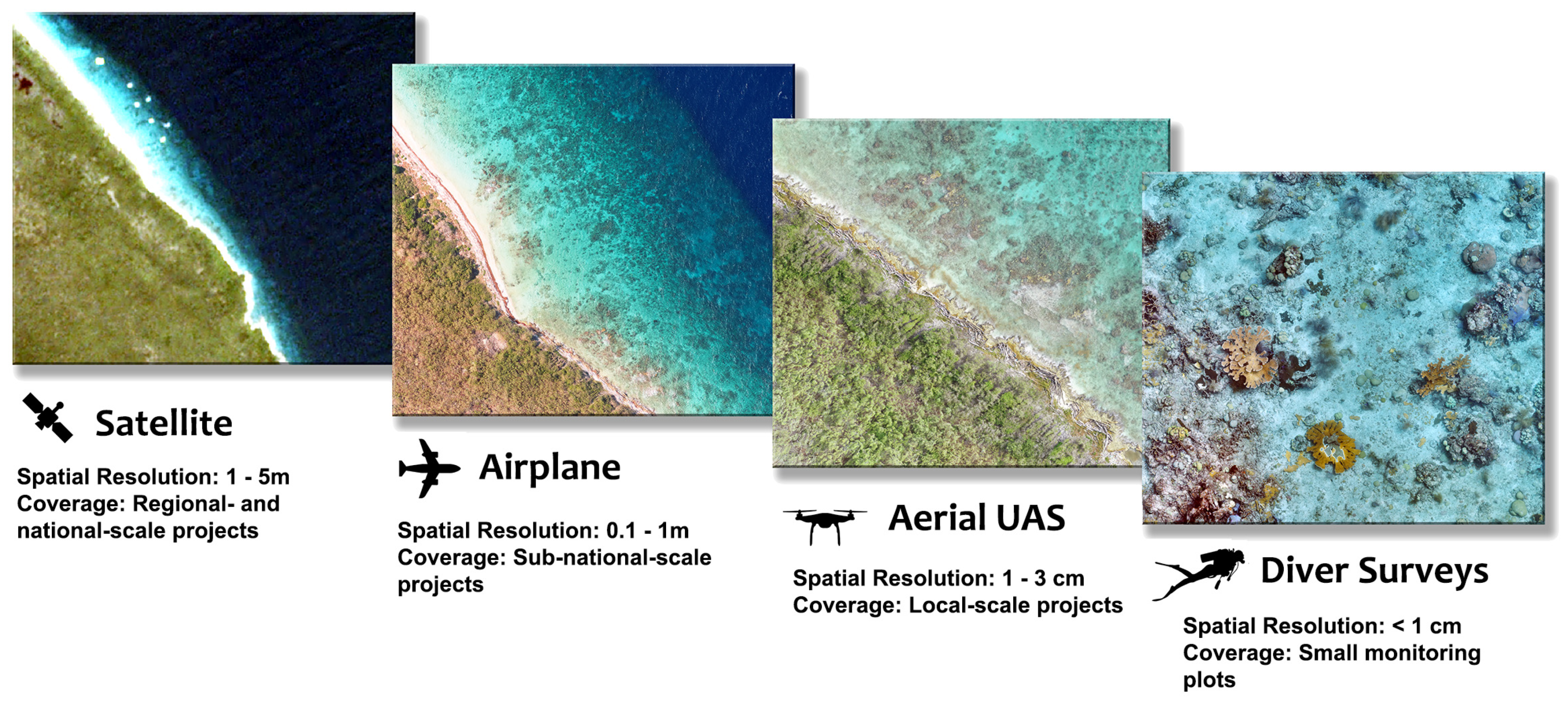
1. Introduction
2. Materials and Methods
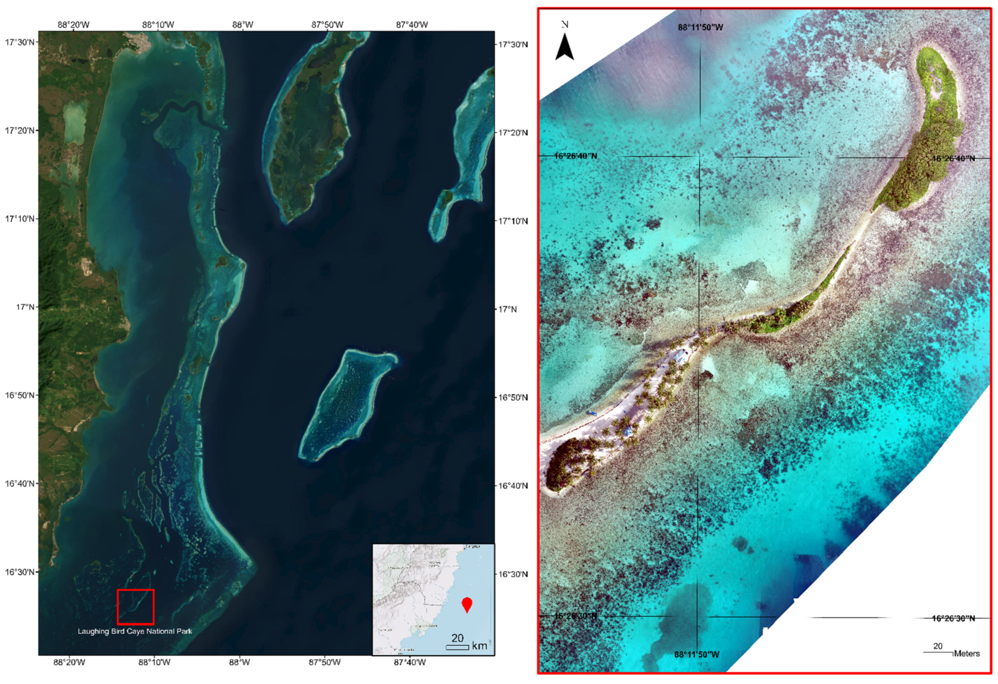
2.1. Study Area
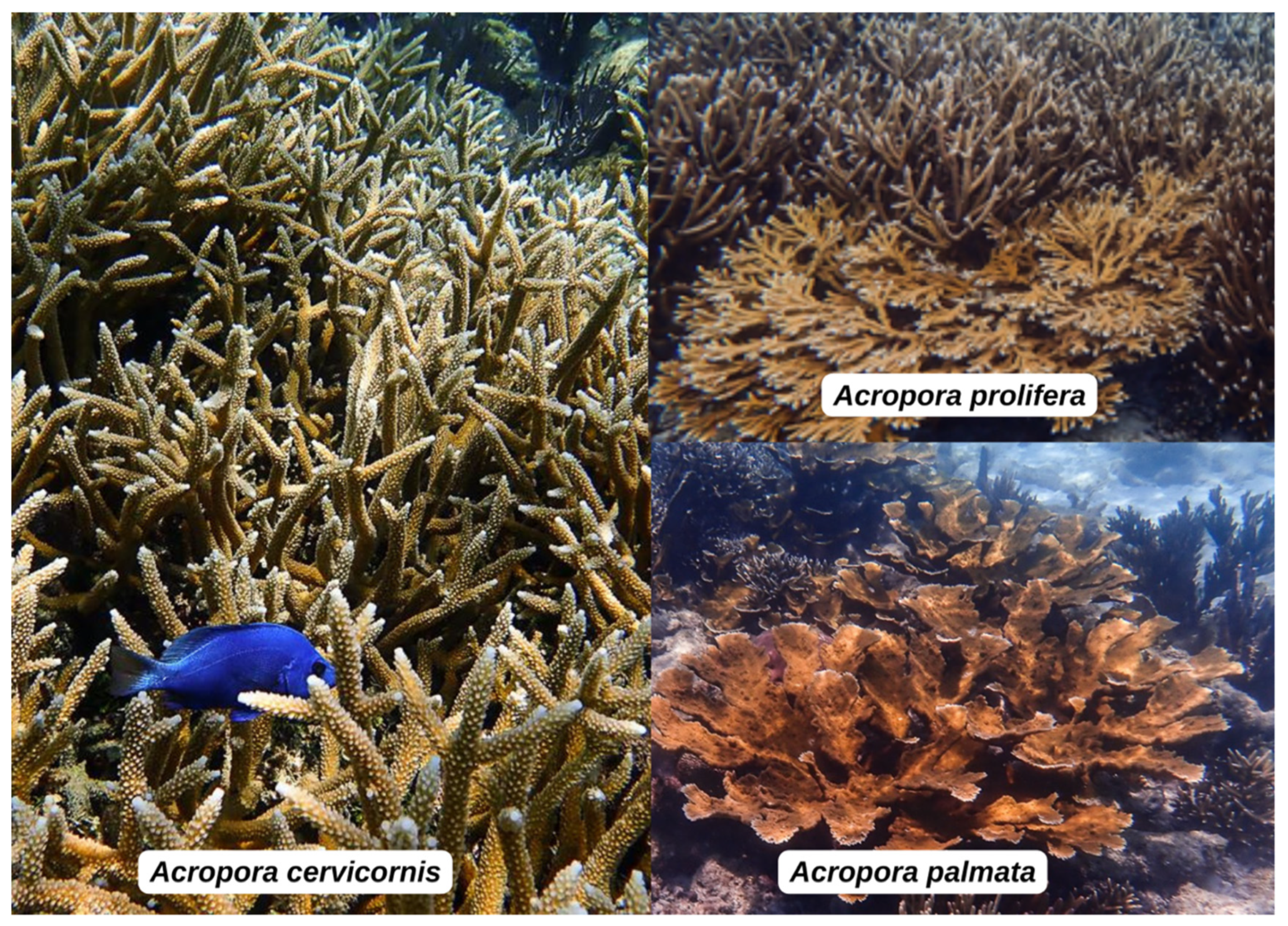
2.2. Coral Restoration Methods and Species of Interest
2.3. UAS Data Collection
2.4. Photogrammetric Processing
2.5. eCognition Segmentation
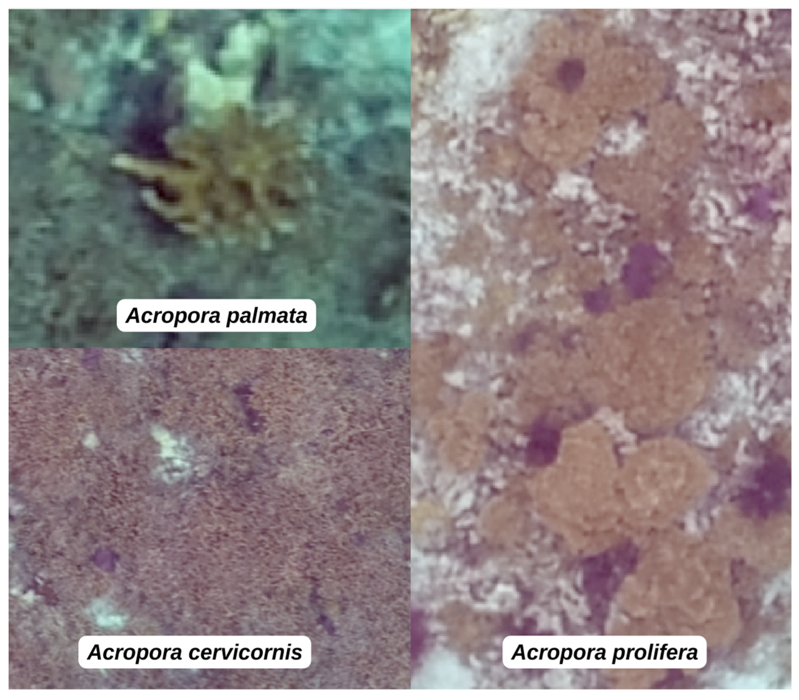
2.6. Manual Classification of Segmented Polygons
2.7. Accuracy Assessment
3. Results
3.1. Coral Cover Quantification
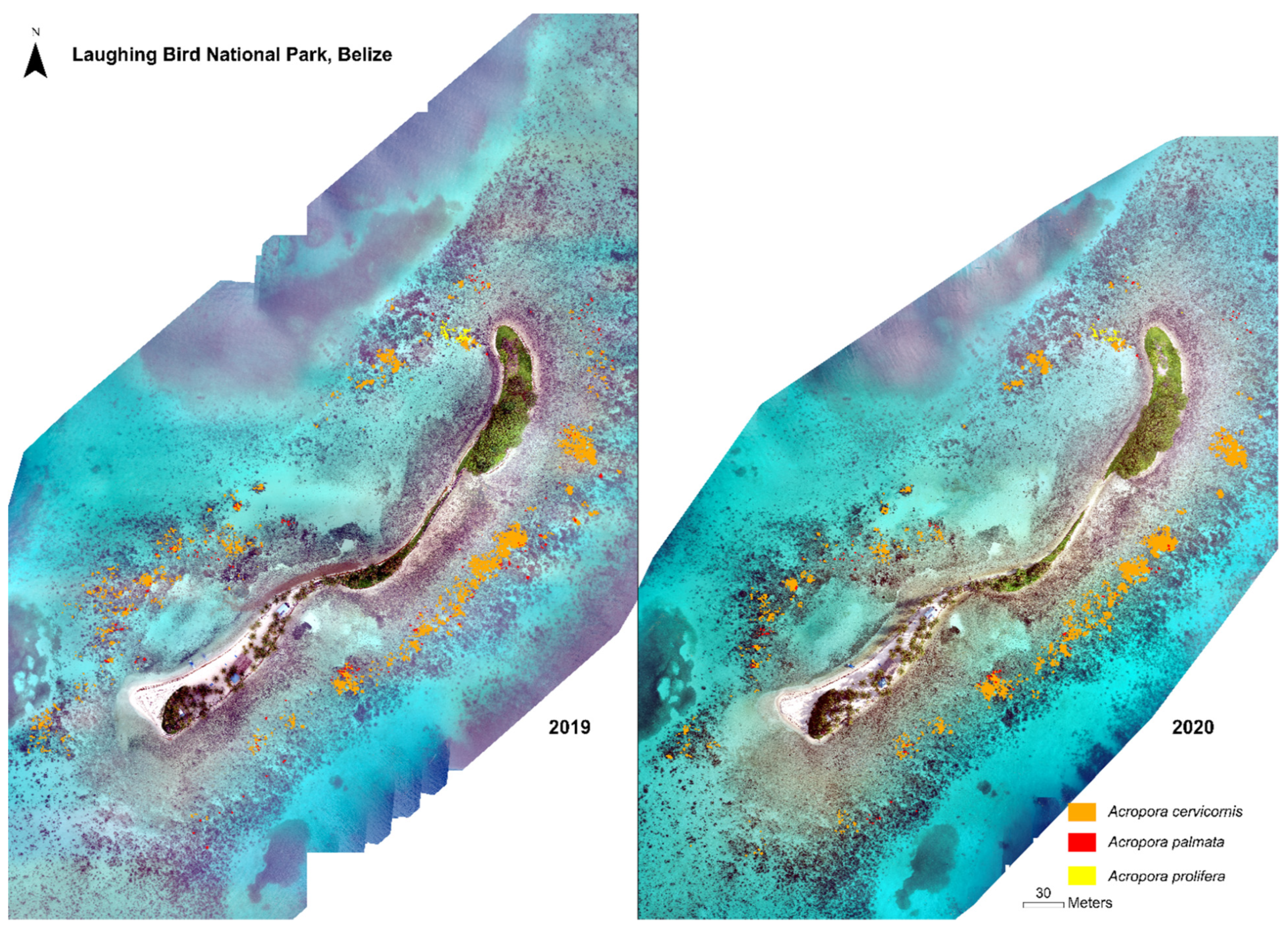
3.2. LBCNP Change Detection, 2019–2020
4. Discussion
5. Conclusions
Author Contributions
Funding
Institutional Review Board Statement
Data Availability Statement
Acknowledgments
Conflicts of Interest
References
- Cesar, H.; Burke, L.; Pet-Soede, L. The Economics of Worldwide Coral Reef Degradation; International Coral Reef Action Network: Cambridge, UK, 2003. [Google Scholar]
- Mumby, P.J.; Hastings, A.; Edwards, H.J. Thresholds and the Resilience of Caribbean Coral Reefs. Nature 2007, 450, 98–101. [Google Scholar] [CrossRef] [PubMed]
- França, F.M.; Benkwitt, C.E.; Peralta, G.; Robinson, J.P.W.; Graham, N.A.J.; Tylianakis, J.M.; Berenguer, E.; Lees, A.C.; Ferreira, J.; Louzada, J.; et al. Climatic and Local Stressor Interactions Threaten Tropical Forests and Coral Reefs. Philos. Trans. R. Soc. B Biol. Sci. 2020, 375, 20190116. [Google Scholar] [CrossRef] [PubMed]
- Boström-Einarsson, L.; Babcock, R.C.; Bayraktarov, E.; Ceccarelli, D.; Cook, N.; Ferse, S.C.A.; Hancock, B.; Harrison, P.; Hein, M.; Shaver, E.; et al. Coral Restoration—A Systematic Review of Current Methods, Successes, Failures and Future Directions. PLoS ONE 2020, 15, e0226631. [Google Scholar] [CrossRef] [PubMed]
- Carne, L.; Baums, I.B. Demonstrating Effective Caribbean Acroporid Population Enhancement: All Three Nursery-grown, Out-planted Taxa Spawn August 2015 & 2016 in Belize. Reef Encount. 2016, 31, 42–43. [Google Scholar]
- Rinkevich, B. Conservation of Coral Reefs through Active Restoration Measures: Recent Approaches and Last Decade Progress. Environ. Sci. Technol. 2005, 39, 4333–4342. [Google Scholar] [CrossRef]
- Quigley, K.M.; Hein, M.; Suggett, D.J. Translating the 10 Golden Rules of Reforestation for Coral Reef Restoration. Conserv. Biol. 2022, 36, e13890. [Google Scholar] [CrossRef]
- Eger, A.M.; Earp, H.S.; Friedman, K.; Gatt, Y.; Hagger, V.; Hancock, B.; Kaewsrikhaw, R.; Mcleod, E.; Moore, A.M.; Niner, H.J.; et al. The Need, Opportunities, and Challenges for Creating a Standardized Framework for Marine Restoration Monitoring and Reporting. Biol. Conserv. 2022, 266, 109429. [Google Scholar] [CrossRef]
- Bayraktarov, E.; Stewart-Sinclair, P.J.; Brisbane, S.; Boström-Einarsson, L.; Saunders, M.I.; Lovelock, C.E.; Possingham, H.P.; Mumby, P.J.; Wilson, K.A. Motivations, Success, and Cost of Coral Reef Restoration. Restor. Ecol. 2019, 27, 981–991. [Google Scholar] [CrossRef]
- Combs, I.R.; Studivan, M.S.; Eckert, R.J.; Voss, J.D. Quantifying Impacts of Stony Coral Tissue Loss Disease on Corals in Southeast Florida through Surveys and 3D Photogrammetry. PLoS ONE 2021, 16, e0252593. [Google Scholar] [CrossRef]
- Knapp, I.S.S.; Forsman, Z.H.; Greene, A.; Johnston, E.C.; Bardin, C.E.; Chan, N.; Wolke, C.; Gulko, D.; Toonen, R.J. Coral Micro-Fragmentation Assays for Optimizing Active Reef Restoration Efforts. PeerJ 2022, 10, e13653. [Google Scholar] [CrossRef]
- Ferrari, R.; Lachs, L.; Pygas, D.R.; Humanes, A.; Sommer, B.; Figueira, W.F.; Edwards, A.J.; Bythell, J.C.; Guest, J.R. Photogrammetry as a Tool to Improve Ecosystem Restoration. Trends Ecol. Evol. 2021, 36, 1093–1101. [Google Scholar] [CrossRef] [PubMed]
- Casella, E.; Collin, A.; Harris, D.; Ferse, S.; Bejarano, S.; Parravicini, V.; Hench, J.L.; Rovere, A. Mapping Coral Reefs Using Consumer-Grade Drones and Structure from Motion Photogrammetry Techniques. Coral Reefs 2017, 36, 269–275. [Google Scholar] [CrossRef]
- Hughes, R.N. Evolutionary Ecology of Colonial Reef-Organisms, with Particular Reference to Corals. Biol. J. Linn. Soc. 1983, 20, 39–58. [Google Scholar] [CrossRef]
- Pittman, S.J. Seascape Ecology; John Wiley & Sons: Hoboken, NJ, USA, 2017. [Google Scholar]
- Turner, M.G.; Gardner, R.H. Landscape Ecology in Theory and Practice; Springer: New York, NY, USA, 2015. [Google Scholar]
- Murfitt, S.L.; Allan, B.M.; Bellgrove, A.; Rattray, A.; Young, M.A.; Ierodiaconou, D. Applications of Unmanned Aerial Vehicles in Intertidal Reef Monitoring. Sci. Rep. 2017, 7, 10259. [Google Scholar] [CrossRef]
- Raber, G.T.; Schill, S.R. A Low-Cost Small Unmanned Surface Vehicle (SUSV) for Very High-Resolution Mapping and Monitoring of Shallow Marine Habitats. In Remote Sensing of the Ocean, Sea Ice, Coastal Waters, and Large Water Regions 2019; Bostater, C.R., Neyt, X., Viallefont-Robinet, F., Eds.; SPIE: Bellingham, WA, USA, 2019; p. 3. [Google Scholar]
- Casella, E.; Rovere, A.; Pedroncini, A.; Stark, C.P.; Casella, M.; Ferrari, M.; Firpo, M. Drones as Tools for Monitoring Beach Topography Changes in the Ligurian Sea (NW Mediterranean). Geo-Mar. Lett. 2016, 36, 151–163. [Google Scholar] [CrossRef]
- Tucker, A.; Pendoley, K.; Murray, K.; Loewenthal, G.; Barber, C.; Denda, J.; Lincoln, G.; Mathews, D.; Oades, D.; Whiting, S.; et al. Regional Ranking of Marine Turtle Nesting in Remote Western Australia by Integrating Traditional Ecological Knowledge and Remote Sensing. Remote Sens. 2021, 13, 4696. [Google Scholar] [CrossRef]
- Joyce, K.E.; Duce, S.; Leahy, S.M.; Leon, J.; Maier, S.W. Principles and Practice of Acquiring Drone-Based Image Data in Marine Environments. Mar. Freshw. Res. 2019, 70, 952. [Google Scholar] [CrossRef]
- Kabiri, K.; Rezai, H.; Moradi, M. A Drone-Based Method for Mapping the Coral Reefs in the Shallow Coastal Waters—Case Study: Kish Island, Persian Gulf. Earth Sci. Inform. 2020, 13, 1265–1274. [Google Scholar] [CrossRef]
- Carne, L. “Conch “Like Sand” at Laughing Bird Caye National Park, Belize. In Proceedings of the Gulf and Caribbean Fisheries Institute, Cumana, Venezuela, 2–6 November 2009; p. 489. [Google Scholar]
- Carne, L. Reef Restoration at Laughing Bird Caye National Park, Belize. 2008. Available online: https://www.academia.edu/8969100/REEF_RESTORATION_AT_LAUGHING_BIRD_CAYE_NATIONAL_PARK_BELIZE_RESTAURACI%C3%93N_DEL_ARRECIFE_EN_EL_PARQUE_NACIONAL_LAUGHING_BIRD_CAYE_BELICE (accessed on 1 February 2023).
- Barton, J.A.; Willis, B.L.; Hutson, K.S. Coral Propagation: A Review of Techniques for Ornamental Trade and Reef Restoration. Rev. Aquac. 2017, 9, 238–256. [Google Scholar] [CrossRef]
- Rinkevich, B. Restoration Strategies for Coral Reefs Damaged by Recreational Activities: The Use of Sexual and Asexual Recruits. Restor. Ecol. 1995, 3, 241–251. [Google Scholar] [CrossRef]
- Lamont, T.A.C.; Razak, T.B.; Djohani, R.; Janetski, N.; Rapi, S.; Mars, F.; Smith, D.J. Multi-Dimensional Approaches to Scaling up Coral Reef Restoration. Mar. Policy 2022, 143, 105199. [Google Scholar] [CrossRef]
- Carne, L. Facilitating Coral Reef Resilience to Climate-Driven Bleaching Incidence through Bioengineering as a Means of Lesson-Learning: A Continuation; Technical Report 6. DW50; World Wildlife Fund: Belize City, Belize, 2021. [Google Scholar]
- Lirman, D. Fragmentation in the Branching Coral Acropora Palmata (Lamarck): Growth, Survivorship, and Reproduction of Colonies and Fragments. J. Exp. Mar. Biol. Ecol. 2000, 251, 41–57. [Google Scholar] [CrossRef]
- Bruckner, A.W.; Hourigan, T.F.; Moosa, M.; Soemodihardjo, S.; Soegiarto, A.; Romimohtarto, K.; Nontji, A.; Suharsono, S. Proactive Management for Conservation of Acropora Cervicornis and Acropora Palmata: Application of the U. S. Endangered Species Act. In Proceedings of the Ninth International Coral Reef Symposium, Bali, Indonesia, 23–27 October 2000; pp. 661–665. [Google Scholar]
- Aronson, R.B.; Macintyre, I.G.; Precht, W.F.; Murdoch, T.J.T.; Wapnick, C.M. The Expanding Scale of Species Turnover Events on Coral Reefs in Belize. Ecol. Monogr. 2002, 72, 233. [Google Scholar] [CrossRef]
- Pandolfi, J.M.; Jackson, J.B.C. Ecological Persistence Interrupted in Caribbean Coral Reefs. Ecol. Lett. 2006, 9, 818–826. [Google Scholar] [CrossRef] [PubMed]
- Young, C.; Schopmeyer, S.; Lirman, D. A Review of Reef Restoration and Coral Propagation Using the Threatened Genus Acropora in the Caribbean and Western Atlantic. Bull. Mar. Sci. 2012, 88, 1075–1098. [Google Scholar] [CrossRef]
- Vollmer, S.V.; Palumbi, S.R. Hybridization and the Evolution of Reef Coral Diversity. Science 2002, 296, 2023–2025. [Google Scholar] [CrossRef] [PubMed]
- Chirayath, V.; Instrella, R. Fluid Lensing and Machine Learning for Centimeter-Resolution Airborne Assessment of Coral Reefs in American Samoa. Remote Sens. Environ. 2019, 235, 111475. [Google Scholar] [CrossRef]
- Raymond, C.M.; Fazey, I.; Reed, M.S.; Stringer, L.C.; Robinson, G.M.; Evely, A.C. Integrating Local and Scientific Knowledge for Environmental Management. J. Environ. Manag. 2010, 91, 1766–1777. [Google Scholar] [CrossRef]
- QGIS Development Team. QGIS Geographic Information System. 2019. Available online: https://www.scirp.org/(S(351jmbntvnsjt1aadkozje))/reference/referencespapers.aspx?referenceid=2631129 (accessed on 1 February 2023).
- DeGraff, A.K.; Ramlal, B. Participatory Mapping: Caribbean Small Island Developing States. In Regional Human Development Report on Multidimensional Progress for Human Development in Latin American and the Caribbean, United Nations Development Report; United Nations Development Programme: New York, NY, USA, 2015. [Google Scholar]
- Paneque-Gálvez, J.; McCall, M.; Napoletano, B.; Wich, S.; Koh, L. Small Drones for Community-Based Forest Monitoring: An Assessment of Their Feasibility and Potential in Tropical Areas. Forests 2014, 5, 1481–1507. [Google Scholar] [CrossRef]
- Lim, J.S.; Gleason, S.; Williams, M.; Linares Matás, G.J.; Marsden, D.; Jones, W. UAV-Based Remote Sensing for Managing Alaskan Native Heritage Landscapes in the Yukon-Kuskokwim Delta. Remote Sens. 2022, 14, 728. [Google Scholar] [CrossRef]
- Kaiser, B.A.; Hoeberechts, M.; Maxwell, K.H.; Eerkes-Medrano, L.; Hilmi, N.; Safa, A.; Horbel, C.; Juniper, S.K.; Roughan, M.; Theux Lowen, N.; et al. The Importance of Connected Ocean Monitoring Knowledge Systems and Communities. Front. Mar. Sci. 2019, 6, 309. [Google Scholar] [CrossRef]
- González-Rivero, M.; Beijbom, O.; Rodriguez-Ramirez, A.; Bryant, D.E.P.; Ganase, A.; Gonzalez-Marrero, Y.; Herrera-Reveles, A.; Kennedy, E.V.; Kim, C.J.S.; Lopez-Marcano, S.; et al. Monitoring of Coral Reefs Using Artificial Intelligence: A Feasible and Cost-Effective Approach. Remote Sens. 2020, 12, 489. [Google Scholar] [CrossRef]
- da Silveira, C.B.L.; Strenzel, G.M.R.; Maida, M.; Gaspar, A.L.B.; Ferreira, B.P. Coral Reef Mapping with Remote Sensing and Machine Learning: A Nurture and Nature Analysis in Marine Protected Areas. Remote Sens. 2021, 13, 2907. [Google Scholar] [CrossRef]
- Beck, M.W.; Losada, I.J.; Menéndez, P.; Reguero, B.G.; Díaz-Simal, P.; Fernández, F. The Global Flood Protection Savings Provided by Coral Reefs. Nat. Commun. 2018, 9, 2186. [Google Scholar] [CrossRef]
- Shaver, E.C.; McLeod, E.; Hein, M.Y.; Palumbi, S.R.; Quigley, K.; Vardi, T.; Mumby, P.J.; Smith, D.; Montoya-Maya, P.; Muller, E.M.; et al. A Roadmap to Integrating Resilience into the Practice of Coral Reef Restoration. Glob. Chang. Biol. 2022, 28, 4751–4764. [Google Scholar] [CrossRef] [PubMed]
- Robinson, J.M.; Harrison, P.A.; Mavoa, S.; Breed, M.F. Existing and Emerging Uses of Drones in Restoration Ecology. Methods Ecol. Evol. 2022, 13, 1899–1911. [Google Scholar] [CrossRef]


| Date/Time | Flying Height (m) (AGL) | Spatial Resolution (cm) | Area Mapped (ha) | Conditions | RMSE (m) |
|---|---|---|---|---|---|
| 01-08-2019 | 60 | 1.8 | 12.4 | Flat seas, scattered clouds | 2.95 |
| 20-08-2020 | 63 | 1.9 | 20.8 | Flat seas, scattered clouds | 3.01 |
| Flying Height (m) (AGL) | Spatial Resolution (cm) | Area Mapped (ha) on One Fully Charged Battery (Optimal Conditions) |
|---|---|---|
| 25 m | 0.7 | 5 |
| 50 m | 1.4 | 21 |
| 75 m | 2.1 | 45 |
| 100 m | 2.7 | 78 |
| 120 m | 3.3 | 94 |
| Species | 2019 m2 | 2020 m2 | Percent Change |
|---|---|---|---|
| Acropora cervicornis | 1938.01 | 2268.43 | +17% |
| Acropora palmata | 151.7 | 90.30 | −40% |
| Acropora prolifera | 52.87 | 41.91 | −21% |
| TOTAL | 2142.58 | 2400.64 | +12% |
Disclaimer/Publisher’s Note: The statements, opinions and data contained in all publications are solely those of the individual author(s) and contributor(s) and not of MDPI and/or the editor(s). MDPI and/or the editor(s) disclaim responsibility for any injury to people or property resulting from any ideas, methods, instructions or products referred to in the content. |
© 2023 by the authors. Licensee MDPI, Basel, Switzerland. This article is an open access article distributed under the terms and conditions of the Creative Commons Attribution (CC BY) license (https://creativecommons.org/licenses/by/4.0/).
Share and Cite
Peterson, E.A.; Carne, L.; Balderamos, J.; Faux, V.; Gleason, A.; Schill, S.R. The Use of Unoccupied Aerial Systems (UASs) for Quantifying Shallow Coral Reef Restoration Success in Belize. Drones 2023, 7, 221. https://doi.org/10.3390/drones7040221
Peterson EA, Carne L, Balderamos J, Faux V, Gleason A, Schill SR. The Use of Unoccupied Aerial Systems (UASs) for Quantifying Shallow Coral Reef Restoration Success in Belize. Drones. 2023; 7(4):221. https://doi.org/10.3390/drones7040221
Chicago/Turabian StylePeterson, Emily Adria, Lisa Carne, Jamani Balderamos, Victor Faux, Arthur Gleason, and Steven R. Schill. 2023. "The Use of Unoccupied Aerial Systems (UASs) for Quantifying Shallow Coral Reef Restoration Success in Belize" Drones 7, no. 4: 221. https://doi.org/10.3390/drones7040221
APA StylePeterson, E. A., Carne, L., Balderamos, J., Faux, V., Gleason, A., & Schill, S. R. (2023). The Use of Unoccupied Aerial Systems (UASs) for Quantifying Shallow Coral Reef Restoration Success in Belize. Drones, 7(4), 221. https://doi.org/10.3390/drones7040221