
Biomass Estimation of Agave durangensis Gentry Using High-Resolution Images in Nombre de Dios, Durango


 , and
, and
Abstract

1. Introduction
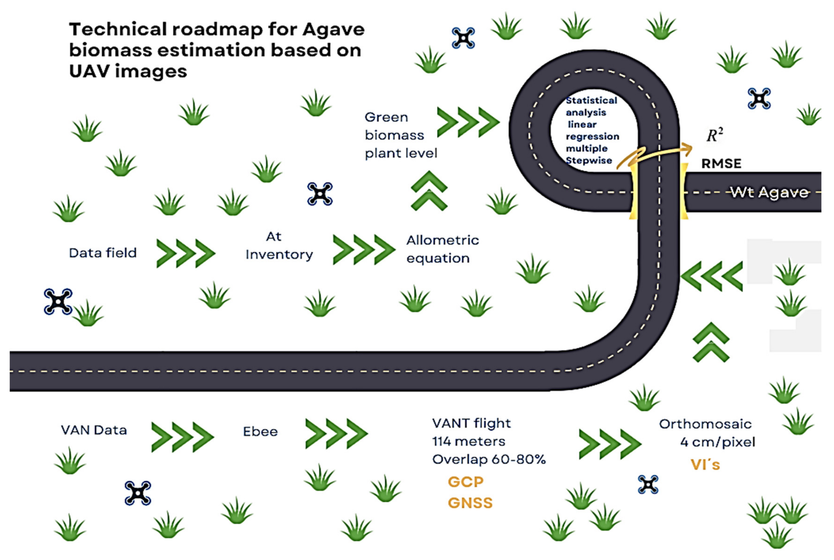
2. Materials and Methods
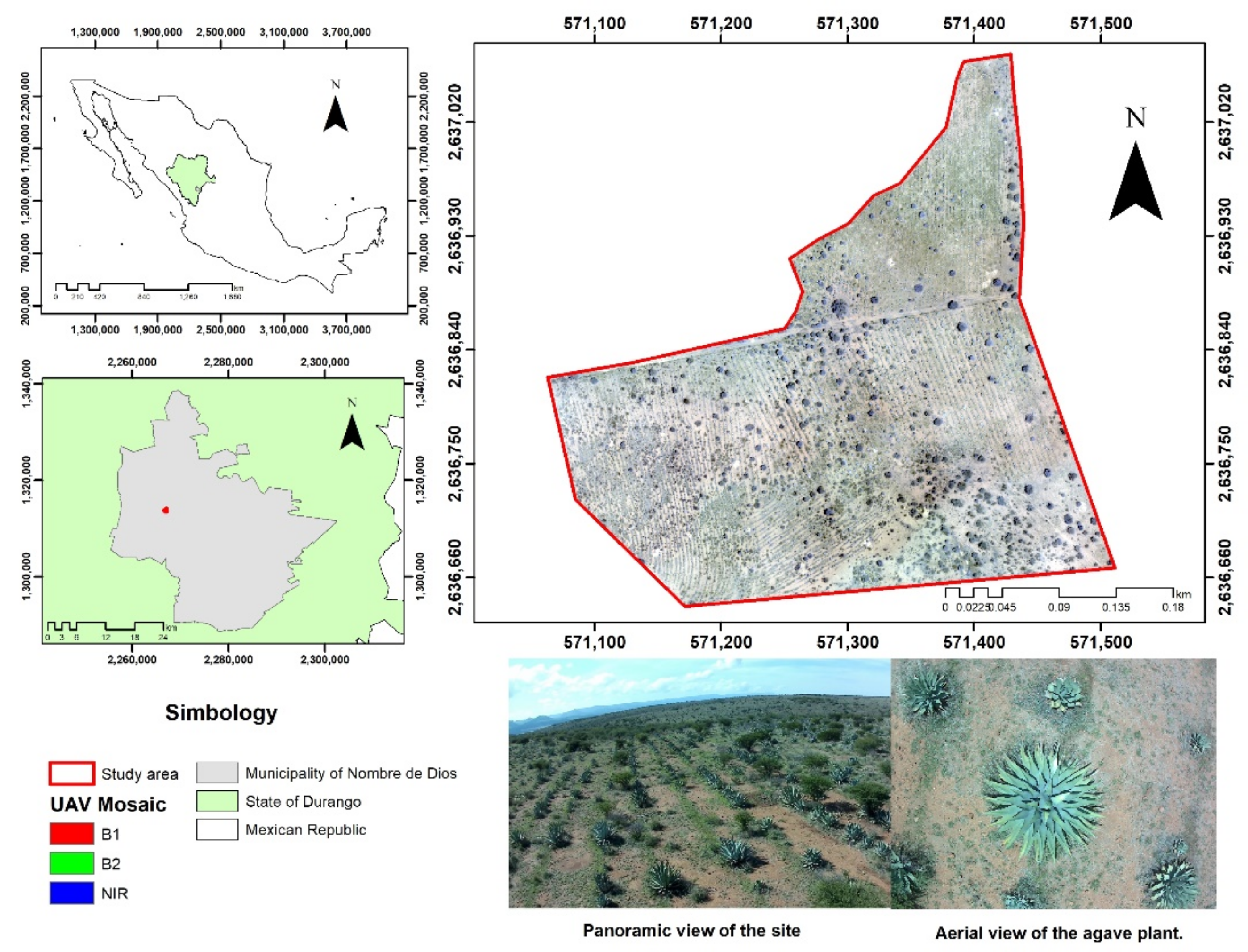
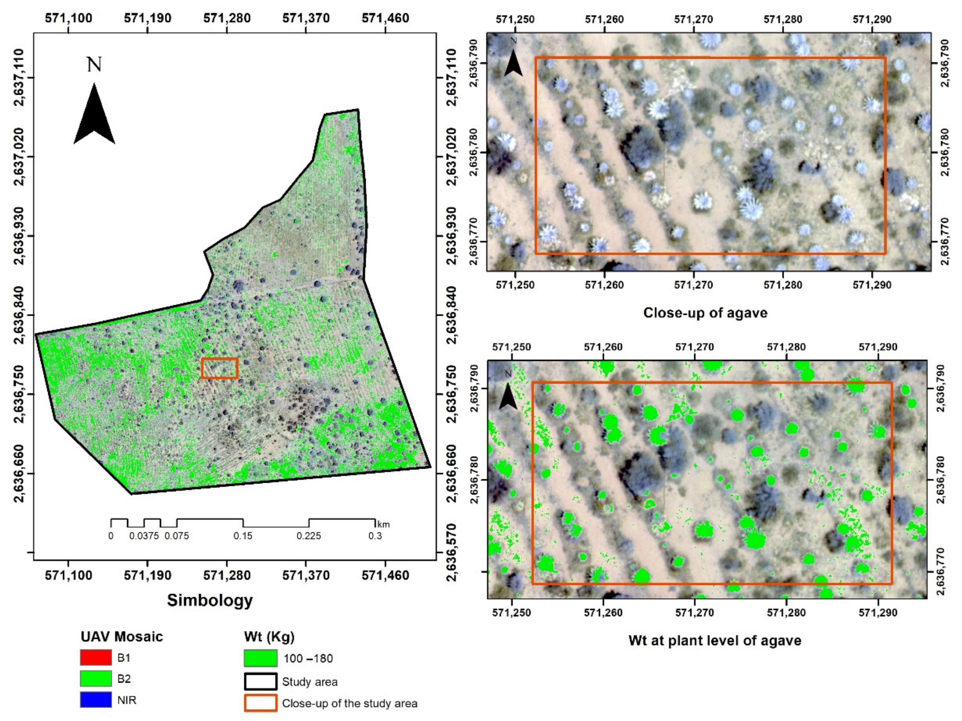
2.1. Study Area
2.2. Estimation of Biomass
2.3. Information Obtained by the Unmanned Aerial Vehicle (UAV)
2.4. Acquisition and Processing of UAV Images

| Index | Formula | Reference |
|---|---|---|
| NDVI (normalized difference vegetation index) | (NIR − red)/(NIR + red) | Rouse et al. [36] |
| GNDVI (green normalized difference vegetation index) | (NIR − green)/(NIR + green) | Gitelson et al. [37] |
| EVI2 (enhanced vegetation index) | 2.5 × (NIR − red)/((NIR + 2.4 × red) + 1) | Jiang et al. [38] |
| SAVI (soil-adjusted vegetation index) | ((NIR − red))/((NIR + red + 0.16)) | Rondeaux et al. [39] |
| SR (simple ratio) | NIR/red | Birth and McVey [40] |
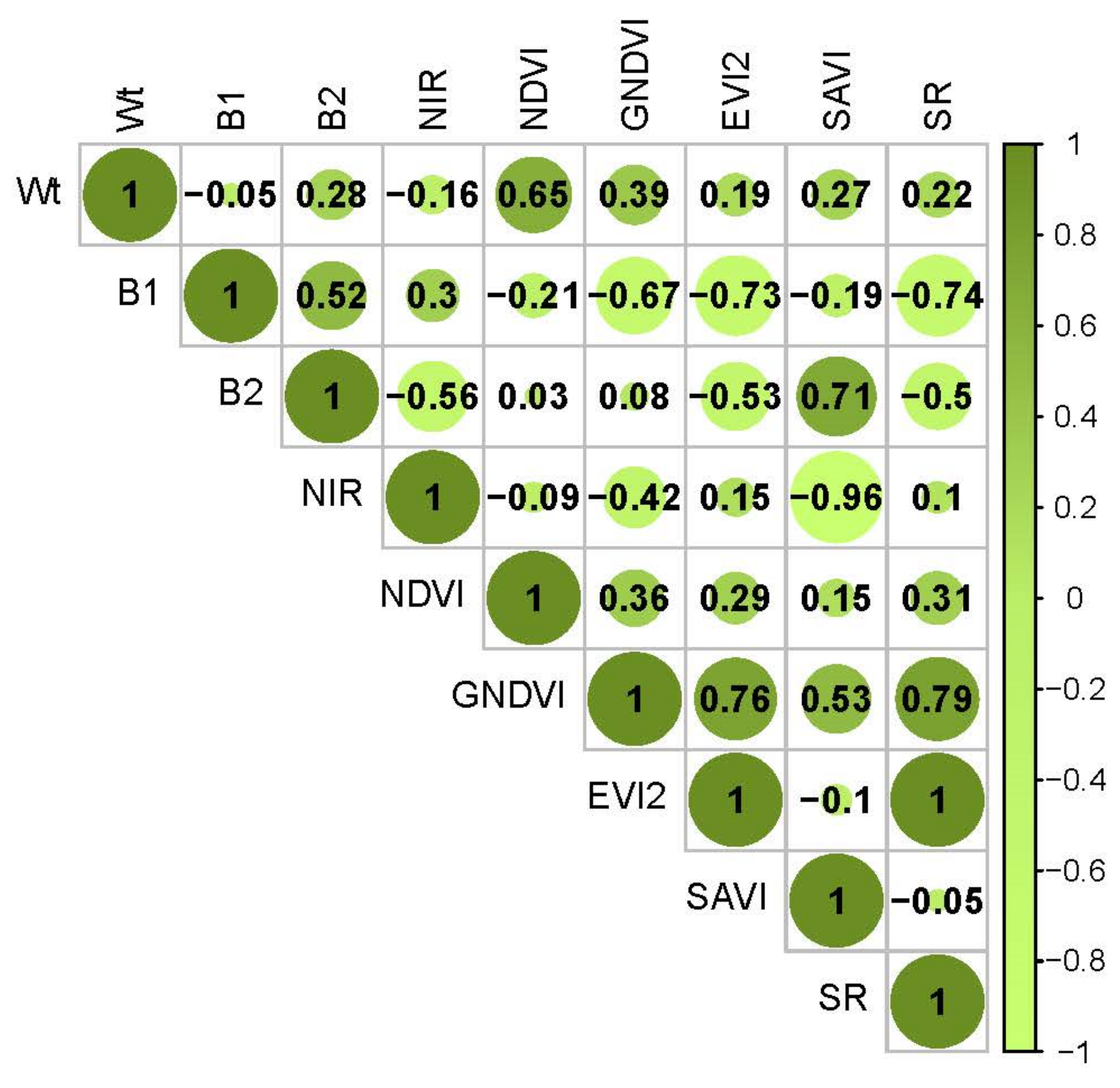
2.5. Statistical Analysis
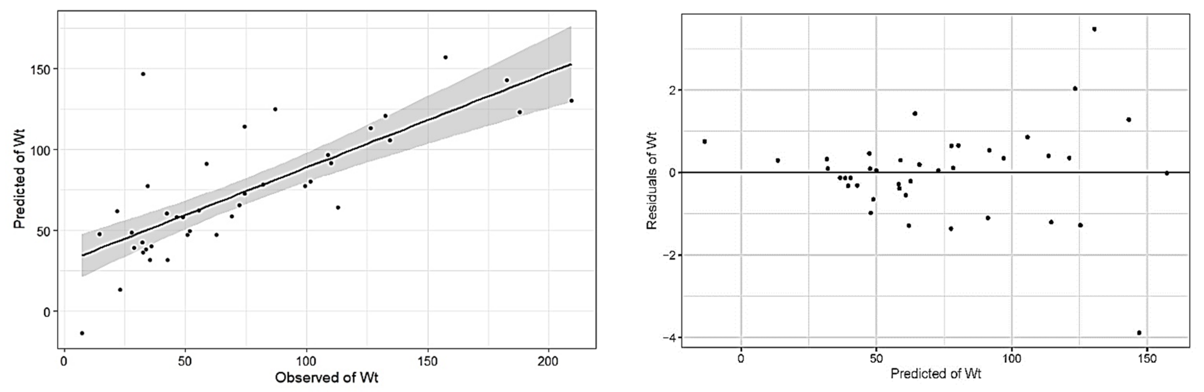
3. Results
4. Discussion
5. Conclusions
Author Contributions
Funding
Institutional Review Board Statement
Informed Consent Statement
Data Availability Statement
Conflicts of Interest
References
- García-Mendoza, A.; Galván-V., R. Riqueza de las familias Agavaceae y Nolinaceae en México. Bot. Sci. 2017, 56, 7–24. [Google Scholar] [CrossRef]
- García-Mendoza, A. Distribution of agave (Agavaceae) in México. Cactus Succul. J. 2002, 74, 177–187, ISSN 0007-9367. [Google Scholar]
- Gschaedler, A.C.; Mora, A.G.; Ramos, S.M.C.; Vazquez, G.D.; Valdez, J.G. Panorama del aprovechamiento de los Agaves en México. In Red Temática Mexicana Aprovechamiento Integral Sustentable y Biotecnología de los Agaves; CIATEJ: Guadalajara, México, 2017; ISBN 978-607-97548-5-3. [Google Scholar]
- Barraza-Soto, S.; Domínguez-Calleros, P.A.; Antuna, E.M. La producción de mezcal en el municipio de Durango, México. Ra Ximhai Rev. Científica De Soc. Cult. Y Desarro. Sosten. 2014, 10, 65–74, e-ISSN 1665-0441. [Google Scholar] [CrossRef]
- Secretariat of the Interior. Secretaria de Gobernación: Diario Oficial de La Federación; SEGOB: Mexico City, Mexico, 2021. [Google Scholar]
- García-Barrón, S.E.; de Jesús Hernández, J.; Gutiérrez-Salomón, A.L.; Escalona-Buendía, H.B.; Villanueva-Rodríguez, S.J. Mezcal y Tequila: Análisis conceptual de dos bebidas típicas de México. Rev. Iberoam. De Vitic. Agroind. Y Rural. 2017, 4, 138–162, e-ISSN 0719-4994. [Google Scholar]
- Rosas Medina, I.; Colmenero Robles, A.; Naranjo JImenez, N.; Rodríguez García, J.H. El Mezcal de Durango, México. In Ingeniantes; Insttuto Tecnologico Superior de Misantla (ITSM): Veracruz, Mexico, 2013; ISSN 2007-3127. [Google Scholar]
- Narváez-Zapata, J.; Sánchez-Teyer, L. Agaves as a Raw Material: Recent Technologies and Applications. Recent Pat. Biotechnol. 2009, 3, 185–191. [Google Scholar] [CrossRef]
- Delgado-Lemus, A.; Torres, I.; Blancas, J.; Casas, A. Vulnerability and risk management of Agave species in the Tehuacán Valley, México. J. Ethnobiol. Ethnomed. 2014, 10, 53. [Google Scholar] [CrossRef]
- Revill, A.; Florence, A.; MacArthur, A.; Hoad, S.P.; Rees, R.M.; Williams, M. The Value of Sentinel-2 Spectral Bands for the Assessment of Winter Wheat Growth and Development. Remote Sens. 2019, 11, 2050. [Google Scholar] [CrossRef]
- Forkuor, G.; Zoungrana, J.-B.B.; Dimobe, K.; Ouattara, B.; Vadrevu, K.P.; Tondoh, J.E. Above-ground biomass mapping in West African dryland forest using Sentinel-1 and 2 datasets-A case study. Remote Sens. Environ. 2019, 236, 111496. [Google Scholar] [CrossRef]
- Wang, L.; Zhou, X.; Zhu, X.; Dong, Z.; Guo, W. Estimation of biomass in wheat using random forest regression algorithm and remote sensing data. Crop J. 2016, 4, 212–219. [Google Scholar] [CrossRef]
- Weiss, M.; Jacob, F.; Duveiller, G. Remote sensing for agricultural applications: A meta-review. Remote Sens. Environ. 2019, 236, 111402. [Google Scholar] [CrossRef]
- Vuorinne, I.; Heiskanen, J.; Pellikka, P. Assessing Leaf Biomass of Agave sisalana Using Sentinel-2 Vegetation Indices. Remote Sens. 2021, 13, 233. [Google Scholar] [CrossRef]
- Zhang, C.; Kovacs, J.M. The application of small unmanned aerial systems for precision agriculture: A review. Precis. Agric. 2012, 13, 693–712. [Google Scholar] [CrossRef]
- Aasen, H.; Burkart, A.; Bolten, A.; Bareth, G. Generating 3D hyperspectral information with lightweight UAV snapshot cameras for vegetation monitoring: From camera calibration to quality assurance. ISPRS J. Photogramm. Remote Sens. 2015, 108, 245–259. [Google Scholar] [CrossRef]
- Esse, C. Estimación del Índice de Sitio en Rodales de Nothofagus Dombeyi a Través de Herramientas de Teledetección Especial; SAFERE: Temuco, Chile, 2015; ISSN 0719-3726. [Google Scholar]
- Gallardo-Salazar, J.L.; Pompa-García, M.; Aguirre-Salado, C.A.; López-Serrano, P.M.; Meléndez-Soto, A. Drones: Tecnología con futuro promisorio en la gestión forestal. Rev. Mex. De Cienc. For. 2020, 11, 27–50. [Google Scholar] [CrossRef]
- Flores, D.; González-Hernández, I.; Lozano, R.; Vazquez-Nicolas, J.M.; Toral, J.L.H. Automated Agave Detection and Counting Using a Convolutional Neural Network and Unmanned Aerial Systems. Drones 2021, 5, 4. [Google Scholar] [CrossRef]
- Del Pozo, S.; Rodríguez-Gonzálvez, P.; Hernández-López, D.; Felipe-García, B. Vicarious Radiometric Calibration of a Multispectral Camera on Board an Unmanned Aerial System. Remote Sens. 2014, 6, 1918–1937. [Google Scholar] [CrossRef]
- González, D.R.; Ramírez, R.C.; Corral, J.A.R.; Salcido, L.A.R.; Garnica, J.G.F. Detección de restricciones en la producción de agave azul (Agave tequilana Weber var. azul) mediante percepción remota. Rev. Terra Latinoam. 2017, 35, 259. [Google Scholar] [CrossRef][Green Version]
- Ayamga, M.; Akaba, S.; Nyaaba, A.A. Multifaceted applicability of drones: A review. Technol. Forecast. Soc. Chang. 2021, 167, 120677. [Google Scholar] [CrossRef]
- Malveaux, C.; Hall, S.G.; Price, R. Using Drones in Agriculture: Unmanned Aerial Systems for Agricultural Remote Sensing Applications Montreal, 13–16 July 2014; American Society of Agricultural and Biological Engineers: Montreal, QC, Canada, 2014. [Google Scholar] [CrossRef]
- Hogan, S.D.; Kelly, M.; Stark, B.; Chen, Y. Unmanned aerial systems for agriculture and natural resources. Calif. Agric. 2017, 71, 5–14. [Google Scholar] [CrossRef]
- Haghighattalab, A.; González Pérez, L.; Mondal, S.; Singh, D.; Schinstock, D.; Rutkoski, J.; Ortiz-Monasterio, I.; Singh, R.P.; Goodin, D.; Poland, J. Application of unmanned aerial systems for high throughput phenotyping of large wheat breeding nurseries. Plant Methods 2016, 12, 1–15. [Google Scholar] [CrossRef]
- Ayamga, M.; Tekinerdogan, B.; Kassahun, A.; Rambaldi, G. Developing a policy framework for adoption and management of drones for agriculture in Africa. Technol. Anal. Strat. Manag. 2020, 33, 970–987. [Google Scholar] [CrossRef]
- Gitelson, A.A.; Kaufman, Y.J.; Stark, R.; Rundquist, D. Novel algorithms for remote estimation of vegetation fraction. Remote Sens. Environ. 2002, 80, 76–87. [Google Scholar] [CrossRef]
- Gilabert, M.A.; González-Piqueras, J.; García-Haro, J. Acerca de los índices de vegetación. Rev. Teledetec. 1997, 8, 1–10. [Google Scholar]
- Gitelson, A.A. Wide Dynamic Range Vegetation Index for Remote Quantification of Biophysical Characteristics of Vegetation. J. Plant Physiol. 2004, 161, 165–173. [Google Scholar] [CrossRef]
- Narasimhan, B.; Srinivasan, R. Development and evaluation of Soil Moisture Deficit Index (SMDI) and Evapotranspiration Deficit Index (ETDI) for agricultural drought monitoring. Agric. For. Meteorol. 2005, 133, 69–88. [Google Scholar] [CrossRef]
- López-Granados, F. Uso de Vehículos Aéreos no tripulados (UAV) para la evaluación de la producción agraria. Ambienta 2013, 105, 40–52, ISSN 1577-9491. [Google Scholar]
- Roy, D.P.; Kovalskyy, V.; Zhang, H.K.; Vermote, E.F.; Yan, L.; Kumar, S.S.; Egorov, A. Characterization of Landsat-7 to Landsat-8 reflective wavelength and normalized difference vegetation index continuity. Remote Sens. Environ. 2016, 185, 57–70. [Google Scholar] [CrossRef]
- De La Casa, A.; Ovando, G. Integración del Índice de Vegetación de la Diferencia Normalizada (NDVI) y del Ciclo Fenológico de Maíz para Estimar el Rendimiento a Escala Departamental en Córdoba, Argentina. Agric. Téc. 2007, 67, 362–371. [Google Scholar] [CrossRef]
- Aguilar, C.G. Aplicación de índices de vegetación derivados de imágenes satelitales para análisis de coberturas vegetales en la provincia de Loja, Ecuador. CEDAMAZ 2015, 5, 30–41, e-ISSN 1390-5902. [Google Scholar]
- Qubaa, A.R.; Aljawwadi, T.A.; Hamdoon, A.N.; Mohammed, R.M. Using uavs/drones and vegetation indices in the visible spectrum to monitoring agricultural lands. Iraqi J. Agric. Sci. 2021, 52, 601–610, ISSN 0075-0530; e-ISSN 2410-0862. [Google Scholar]
- Rouse, J.; Haas, R.H.; Schell, J.A.; Deering, D.W. Monitoring Vegetation Systems in the Great Plains with ERTS. In Proceedings of the Third Earth Resources Technology Satellite-1 Symposium NASA SP-351, Greenbelt, MD, USA, 1 January 1974; pp. 301–317. Available online: https://ntrs.nasa.gov/citations/19740022592 (accessed on 10 June 2022).
- Gitelson, A.A.; Kaufman, Y.J.; Merzlyak, M.N. Use of a green channel in remote sensing of global vegetation from EOS-MODIS. Remote Sens. Environ. 1996, 58, 289–298. [Google Scholar] [CrossRef]
- Jiang, Z.; Huete, A.R.; Didan, K.; Miura, T. Development of a two-band enhanced vegetation index without a blue band. Remote Sens. Environ. 2008, 112, 3833–3845. [Google Scholar] [CrossRef]
- Rondeaux, G.; Steven, M.; Baret, F. Optimization of soil-adjusted vegetation indices. Remote Sens. Environ. 1996, 55, 95–107. [Google Scholar] [CrossRef]
- Birth, G.S.; McVey, G.R. Measuring the Color of Growing Turf with a Reflectance Spectrophotometer. Agron. J. 1968, 60, 640–643. [Google Scholar] [CrossRef]
- Quantum GIS Geographic Information System. Open Source Geospatial Foundation Project. Available online: http://www.qgis.org/it/site/ (accessed on 10 June 2022).
- Team, R.C. R: A Language and Environment for Statistical Computing; R Foundation for Statistical Computing: Vienna, Austria, 2013. [Google Scholar]
- Ripley, B.; Venables, B.; Bates, D.M.; Hornik, K.; Gebhardt, A.; Firth, D.; Ripley, M.B. Package ‘mass’. Cran R 2013, 538, 113–120. [Google Scholar]
- Hijmans, R. Raster: Geographic Data Analysis and Modeling (R Package Version 3.3-13) [Computer Software]. 2020. Available online: https://CRAN.R-project.org/package=raster (accessed on 15 April 2022).
- Carlson, T.N.; Ripley, D.A. On the relation between NDVI, fractional vegetation cover, and leaf area index. Remote Sens. Environ. 1997, 62, 241–252. [Google Scholar] [CrossRef]
- Hassan, M.A.; Yang, M.; Rasheed, A.; Yang, G.; Reynolds, M.P.; Xia, X.; Xiao, Y.; He, Z. A rapid monitoring of NDVI across the wheat growth cycle for grain yield prediction using a multi-spectral UAV platform. Plant Sci. 2018, 282, 95–103. [Google Scholar] [CrossRef]
- Broge, N.H.; Leblanc, E. Comparing prediction power and stability of broadband and hyperspectral vegetation indices for estimation of green leaf area index and canopy chlorophyll density. Remote Sens. Environ. 2001, 76, 156–172. [Google Scholar] [CrossRef]
- Clevers, J.G.P.W.; Kooistra, L.; van den Brande, M.M.M. Using Sentinel-2 Data for Retrieving LAI and Leaf and Canopy Chlorophyll Content of a Potato Crop. Remote Sens. 2017, 9, 405. [Google Scholar] [CrossRef]
- Jiang, Z.; Huete, A.; Kim, Y.; Didan, K. 2-band enhanced vegetation index without a blue band and its application to AVHRR data. In Remote Sensing and Modeling of Ecosystems for Sustainability IV; SPIE: Tucson, AZ, USA, 2007. [Google Scholar] [CrossRef]


| Component | Model | Parameter | R2 | RMSE |
|---|---|---|---|---|
| Total green biomass (Wt) | = 0.308681 = −0.00229 = 0.000018 | 0.79 | 28.99 |
| Band | Wavelength (µm) | Spatial Resolution (cm) | Abbreviation |
|---|---|---|---|
| Green | 0.54–0.57 | 5 | B1 |
| Red | 0.65–0.68 | 5 | B2 |
| Near-infrared | 0.78–0.90 | 5 | NIR |
| Variable | Mínimum | Máximum | Mean | Standard Deviation |
|---|---|---|---|---|
| D (cm) | 54.4 | 205 | 126.06 | 36.75 |
| At (cm) | 46 | 157 | 101.53 | 24.65 |
| Wt (Kg) | 7.26 | 209.39 | 71.81 | 48.73 |
| Model | Parameter | R2 | RMSE |
|---|---|---|---|
| Wt = β0 + β1B1 + β2B2 + β3NDVI + β4GNDVI + β5EVI2 + β6SAVI | β0 = −528.17 | 0.59 | 32.06 kg |
| β1 = −33.08 | |||
| β2 = 36.43 | |||
| β3 = 859.66 | |||
| β4 = −11,476.71 | |||
| β5 = 7035.82 | |||
| β6 = −15.79 |
Publisher’s Note: MDPI stays neutral with regard to jurisdictional claims in published maps and institutional affiliations. |
© 2022 by the authors. Licensee MDPI, Basel, Switzerland. This article is an open access article distributed under the terms and conditions of the Creative Commons Attribution (CC BY) license (https://creativecommons.org/licenses/by/4.0/).
Share and Cite
López-Serrano, P.M.; Núñez-Fernández, G.A.; Alvarado-Barrera, R.; García-Montiel, E.; Ramírez-Aldaba, H.; Bocanegra-Salazar, M. Biomass Estimation of Agave durangensis Gentry Using High-Resolution Images in Nombre de Dios, Durango. Drones 2022, 6, 148. https://doi.org/10.3390/drones6060148
López-Serrano PM, Núñez-Fernández GA, Alvarado-Barrera R, García-Montiel E, Ramírez-Aldaba H, Bocanegra-Salazar M. Biomass Estimation of Agave durangensis Gentry Using High-Resolution Images in Nombre de Dios, Durango. Drones. 2022; 6(6):148. https://doi.org/10.3390/drones6060148
Chicago/Turabian StyleLópez-Serrano, Pablito Marcelo, Gerardo A. Núñez-Fernández, Rolando Alvarado-Barrera, Emily García-Montiel, Hugo Ramírez-Aldaba, and Melissa Bocanegra-Salazar. 2022. "Biomass Estimation of Agave durangensis Gentry Using High-Resolution Images in Nombre de Dios, Durango" Drones 6, no. 6: 148. https://doi.org/10.3390/drones6060148
APA StyleLópez-Serrano, P. M., Núñez-Fernández, G. A., Alvarado-Barrera, R., García-Montiel, E., Ramírez-Aldaba, H., & Bocanegra-Salazar, M. (2022). Biomass Estimation of Agave durangensis Gentry Using High-Resolution Images in Nombre de Dios, Durango. Drones, 6(6), 148. https://doi.org/10.3390/drones6060148