Communication

Verification of the Detection Performance of Drone Radio Telemetry for Tracking the Movement of Frogs

Faculty of Bioenvironmental Science, Kyoto University of Advanced Science, 1-1 Sogabe-cho Nanjyo Otani, Kyoto 621-8555, Japan
*
Author to whom correspondence should be addressed.
Drones 2021, 5(4), 139; https://doi.org/10.3390/drones5040139
Submission received: 16 October 2021 / Revised: 9 November 2021 / Accepted: 20 November 2021 / Published: 23 November 2021

Abstract

:
Elucidating the various behavioral and ecological uses of animal habitats is the basis for the conservation and management of animal species. Therefore, tracking the movement of animals is necessary. Biotelemetry is used for tracking the movement of animals. By mounting a radio telemetry receiver and antenna on a drone, the time and labor required for surveying animals can be reduced. In addition, it is easy to track difficult-to-reach areas such as rice paddies and forests, and the environment is not invaded by the survey. We think that this drone radio telemetry will be the best method for tracking the movement of small amphibians, such as frogs. However, in order to put the method to practical use, the accuracy of the system needs to be verified. Approximately 26 ha of area in Sogabe, Kameoka City, Kyoto Prefecture, Japan was investigated in this study. We selected and validated the location where frogs are likely to enter farmlands. The location where the detection of movement is expected to be stable are 5 cm deep areas in the soil, gaps in masonry, and under plastic bags, whereas areas in which the detection is likely to be unstable are areas deeper than 5 cm in the soil, covered concrete channels, and grass. By calculating the geographic center, the location of the nanotag could be estimated with an accuracy of less than 16 m. We successfully showed that the drone radio telemetry system used in this study is capable of detecting and tracking the movement of animals with high spatial and temporal resolutions. However, we suggest that the detection of movement may be interrupted depending on the location of the target animal and more than three detections are needed to guarantee the accuracy of the estimation.

Graphical Abstract

1. Introduction

Elucidating behavioral areas, feeding sites and times, migratory routes, dispersal behavior, habitat use, and preferences of animals is fundamental to their conservation and management. Integrating large amounts of tracking data can also help to scientifically select Areas of Ecological Significance (AESs) [1,2]. To elucidate these factors, it is necessary to track the movements of animals. However, only a limited number of species have been studied, mainly due to the limitations of available survey techniques. Therefore, developing new methods and technologies to survey species that have been difficult to track will provide new possibilities for animal conservation and management [3].
Telemetry is commonly used for animal tracking. In telemetry, a transmitter or a receiver is attached to the body of an animal. The movement of the animal is tracked based on the radio wave information transmitted and received from satellites or antennas on the ground. The telemetry used for animal tracking can be broadly classified into global navigation satellite system (GNSS) telemetry, radio telemetry, and microchip telemetry. In GNSS telemetry, a GNSS receiver attached to the animal receives radio signals from satellites and automatically records the movement of the animal. GNSS telemetry is mainly used for tracking large animals [1,4] because it is challenging to attach receivers to small animals, such as frogs. Nonetheless, receivers are becoming smaller and lighter, enabling their usage in small animals. In microchip telemetry, an electronic labeling device is implanted in an animal and detected by a scanner that transmits radio waves. An electronic labeling device is small and lightweight and can be attached to small animals. It has previously been used to study frogs and small salamanders [5]. However, scanners work only within a close range, requiring a great deal of time and effort to traverse, and are not suitable for tracking over wide areas.
In radio telemetry, a very short wave (VHF) transmitter is attached to an animal, and a portable or fixed antenna is used to track and locate it by detecting radio waves from the transmitter. The transmitter is less expensive than a GNSS receiver and compact and lightweight transmitters are being commercialized. Transmitters have been used to survey fishes [6,7,8], turtles [9], and rodents [10], and it is becoming possible to attach them to small amphibians, such as frogs, if the individual size is selected. However, the range of radio waves is limited, and some terrains block these radio waves, making the process of tracking time-consuming and labor-intensive. These features made it difficult to track animals that moved over large areas.
Nonetheless, if the antenna for radio telemetry is mounted on a drone (unoccupied aerial vehicle; UAV), it will not only reduce the time and labor required for surveying but also make it easier to track difficult-to-reach areas, such as rice paddies and forests, without invading the environment through surveying. This drone radio telemetry is currently the best method for tracking the movement of small amphibians, such as frogs. Drone radio telemetry has been under development since around 2010 [11] and remained in the theoretical and simulation stages around 2015 [12]. However, Yamamoto et al. [13] used a combination of drones and handheld antennas to locate the overwintering location of Pacifastacus leniusculus equipped with radio transmitters. However, the use of drone radio telemetry has been limited to searching for the current location of a specific animal within a few days to a few months, and the drone radio telemetry to detect and track the movement of animals with high spatial and temporal resolutions has not been established. Although drone radio telemetry has an excellent potential to facilitate animal tracking, the use of the acquired data is limited if the accuracy cannot be estimated [14,15]. Therefore, it is necessary to establish drone radio telemetry as a system that can track the movement of small amphibians, such as frogs, through accuracy verification and technical improvements.
We herein validated the detection performance of drone radio telemetry to detect and track the movement of small amphibians, such as frogs, with high spatial and temporal resolutions.

2. Materials and Methods

2.1. Study Area

The study area was approximately 26 ha in Sogabe, Kameoka City, Kyoto Prefecture, Japan (Figure 1). Small-scale, irregularly shaped rice paddies have been preserved in the study area. In addition, stone masonry, earthen canals, and dug-up canals are present. In Kameoka City, the national Kameoka Central Agricultural Land Improvement Project is underway, and the surveyed area is included in the Sogabe construction area where construction began in 2018. The surveyed area is adjacent to the farmland before and after the field improvement.

2.2. Drone Radio Telemetry System

The radio transmitter used in this study was a LOTEK NTQB2-3-2 (hereafter referred to as a “nanotag”) for terrestrial animals. If the weight of the radio transmitter attached to the animal is within 5% of the weight of the animal, it was assumed it would have little effect on behavior [15]. Therefore, this nanotag (weight 0.62 g) can be used for frogs weighing 12.4 g or more. The radio transmitter was licensed by the Ministry of Internal Affairs and Communications.
We used a drone (DJI Phantom Pro 4, Tokyo, Japan) equipped with a radio receiver and an antenna that can receive radio waves from nanotags developed by Tanaka Sanjiro Shoten Co. (Figure 2). The detection of radio waves may be confirmed by this system in real-time by emitting LEDs. The position of the animal, the strength of the radio wave, and the ID of the nanotag were recorded after radio wave detection.

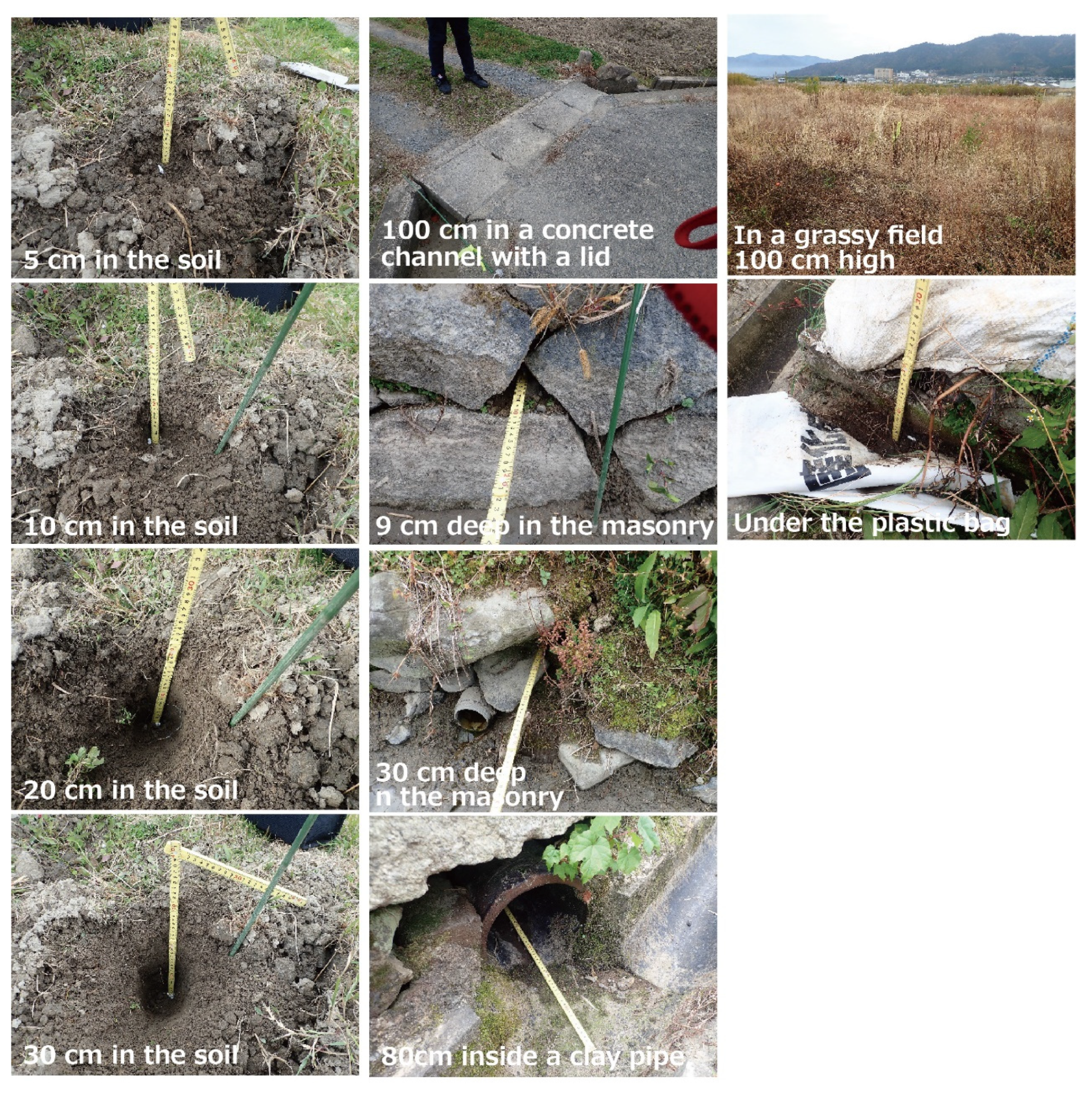
2.3. Comparison of Detection Performance by Location

Two nanotags with different IDs were placed at two different locations (Figure 3), and the drone was flown five times in the same settings. The standard flight altitude of the drone was 30 m, and the course interval was also 30 m. The radio transmission interval of the nanotag was set to 5 s. Therefore, the drone flew at 21.6 km/h, covering 30 m in 5 s. The distance between the radio wave detected points and the nanotag location was calculated in a geographic information system (GIS) and we calculated the basic statistics of those distances. We calculated the geographic center of all detected points and the distance between the geographic center and the nanotag location.

2.4. Comparison of Detection Performance by Multiple Flights

The drone was set to fly at an altitude of 30 m and a course interval of 30 m. Since the radio transmission interval of the nanotag was set to 5 s, the drone flew at 21.6 km/h, covering 30 m in 5 s. The nanotags were placed directly below and in the middle of the flight path. The survey date was 8 March 2021. The distance between the radio wave detected points and the nanotag location was calculated. The basic statistics of those distances were calculated. We calculated the distance between the geographic center and the nanotag location. We combined the two validation results to show the relationship among the distance between the geographic center, the nanotag location, and the number of detections. We analyzed the relationship between the number of detections and the distance between the geographic center of the detected points and the nanotag.

3. Results

3.1. Comparison of Detection Performance by Tag Locations

The detection results for each location are shown in Table 1. The nanotag locations, detection points, and geographic centers are shown in Figure 4. In the soil, the number of detections was high at 5 cm, but decreased at 10 cm and above. At 30 cm, it was undetectable. No detection was made in the covered concrete channel. The number of detections in masonry decreased as we moved deeper into it. Inside the earthen pipe, the number of detections was one. In a grassy area with a vegetation height of 1 m, the number of detections was one. The detection point was 61 m away from the nanotag location. Under a plastic bag, the number of detections was high, and the tag was detected in all directions of the nanotag location. The average distance between the detected points was received and the nanotag location was 32 m when the number of detections was two or more. The average distance between the geographic center and the nanotag location was 35 m for one detection and 7 m for two or more detections.

3.2. Comparison of Detection Performance with Multiple Flights

The detection results of multiple flights are shown in Table 2, and the nanotag locations, detection points, and geographic centers are shown in Figure 5. The number of detections varied from 2 to 6, depending on the flight times. The average distance between the nanotag location and the detected points was 29 m for tag ID 162 and 30 m for tag ID 46. The mean distance between the geographic center and the nanotag location was 16 m for tag ID 162 and 12 m for tag ID 46. The difference between the aggregate values directly below the flight path (tag ID 162) and in the middle (tag ID 46) was less than 4 m.

3.3. Relationship among the Distance from the Geographic Center of the Detection Points, the Nanotag Location, and the Number of Detections

We showed the relationship among the distance between the geographic center, the nanotag location, and the number of detections in a scatter plot, fitted a logarithmic regression equation, and illustrated the 95% confidence range (Figure 6). The detection number 1 had an outlier (61 m). The distance between the geographic center and the nanotag location was long. As the number of detections increased, the distance between the geographic center and the nanotag location became shorter. The distance was less than 20 m for three or more detections.

4. Conclusions

4.1. Nanotag Detection

We selected and validated the locations where frogs are likely to enter in paddy fields. The locations which can be detected consistently are 5 cm deep areas in the soil, gaps in masonry, under plastic bags, whereas locations where detection may not be stable are areas deeper than 5 cm in the soil, covered concrete channels, and grass. If we apply these results to the ecology of frogs living in paddy fields, we can assume that frogs cannot be detected when (1) they are hibernating deep in the soil, (2) they have been washed away in a covered concrete channel, or (3) they are in a fallow field with high vegetation. If they can be detected, their positional accuracy may decrease. Even with radiotelemetry, radio waves are reflected and attenuated by rocks and soil, making it difficult to locate them [16]. These results suggest that when detecting and tracking the movement of frogs living around paddy fields, with high spatial and temporal resolutions, detection may be interrupted depending on the location of the frogs.

4.2. Spatial Accuracy of Nanotag Detection Points

The average distance between the detected points and the nanotag location ranged from 29 m to 35 m. However, the distance between the geographic center and the nanotag location, excluding detection number one, ranged from 7 m to 16 m. Based on the calculation of the geographic center, it was found that the location of the nanotag could be estimated with an accuracy of less than 16 m. However, more than three detections are needed to guarantee the accuracy of the estimation. The location estimation accuracy of the previous study is 22.7 ± 13.9 m [17] and 25.9 ± 25.2 m [18], and the accuracy of our system can be said to be high. If we use the drone radio telemetry system used in this study to track the frogs at a high frequency, we will be able to track the frog’s movements if they move more than about 16 m.

4.3. Future Work

We successfully showed that the drone radio telemetry system used in this study is capable of detecting and tracking the movement of animals with high spatial and temporal resolutions. However, it is suggested that the detection might be interrupted, depending on the location of the target animal. In addition, although only nanotags were installed in this study, the size of the target animal may have affected the detection performance when the tags were attached to the animals. Few studies have actually used the drone radio telemetry system to track organisms [18]. In the future, it will be necessary to continue verifying in various environments and animals to further clarify the relationship between the location of the target animal and the detection performance. In addition, it is necessary to improve the reception performance by improving receivers and antennas.

Author Contributions

Conceptualization, H.N.; methodology, H.N.; software, H.N.; validation, H.N.; formal analysis, H.N.; investigation, H.N. and Y.S.; resources, H.N.; data curation, H.N. and Y.S.; writing—original draft preparation, H.N.; writing—review and editing, H.N.; visualization, H.N.; supervision, H.N.; project administration, H.N. All authors have read and agreed to the published version of the manuscript.

Funding

This research received no external funding.

Institutional Review Board Statement

Not applicable.

Informed Consent Statement

Not applicable.

Data Availability Statement

Not applicable.

Conflicts of Interest

The authors declare no conflict of interest.

References

  1. Hindell, M.A.; Reisinger, R.R.; Ropert-Coudert, Y.; Hückstädt, L.A.; Trathan, P.N.; Bornemann, H.; Charrassin, J.-B.; Chown, S.L.; Costa, D.P.; Danis, B.; et al. Tracking of marine predators to protect Southern Ocean ecosystems. Nature 2020, 580, 87–92. [Google Scholar] [CrossRef] [PubMed] [Green Version]
  2. Ropert-Coudert, Y.; Van de Putte, A.P.; Reisinger, R.R.; Bornemann, H.; Charrassin, J.-B.; Costa, D.P.; Danis, B.; Hückstädt, L.A.; Jonsen, I.D.; Lea, M.-A.; et al. The retrospective analysis of Antarctic tracking data project. Sci. Data 2020, 7, 94. [Google Scholar] [CrossRef] [PubMed]
  3. Black, S.A. Assessing Presence, Decline, and Extinction for the Conservation of Difficult-to-Observe Species BT. In Problematic Wildlife II: New Conservation and Management Challenges in the Human-Wildlife Interactions; Angelici, F.M., Rossi, L., Eds.; Springer International Publishing: Cham, Switzerland, 2020; pp. 359–392. ISBN 978-3-030-42335-3. [Google Scholar]
  4. Shafer, M.W.; Vega, G.; Rothfus, K.; Flikkema, P. UAV wildlife radiotelemetry: System and methods of localization. Methods Ecol. Evol. 2019, 10, 1783–1795. [Google Scholar] [CrossRef]
  5. Ueno, Y.; Sonoda, Y.; Matsue, M.; Kurihara, M. Monitoring techniques of small salamander using microtip. Ecol. Civ. Eng. 2015, 17, 101–104. [Google Scholar] [CrossRef] [Green Version]
  6. Aruga, M.; Tsuda, Y.; Fujioka, K.; Honda, K.; Mitsunaga, Y.; Mihara, K.; Miyashita, K. Upriver migration of chum salmon, Oncorhynchus keta, in the Ishikari River. Ecol. Civ. Eng. 2009, 12, 119–130. [Google Scholar] [CrossRef]
  7. Nii, H.; Makiguchi, Y.; Fujii, M. Upriver spawning migration of shishamo smelt Spirinchus lanceolatus assessed by radio telemetry. Fish. Sci. 2010, 76, 855–869. [Google Scholar]
  8. Mori, A.; Mizutani, M.; Goto, A. Monitoring of activity of catfish Silurus asotus with acoustic telemetry in a small stream. Ecol. Civ. Eng. 2013, 16, 23–35. [Google Scholar] [CrossRef] [Green Version]
  9. Hara, Y.; Ohsugi, T.; Yokoo, K.; Oda, Y.; Fukui, D.; Takenaka, T.; Arimoto, S. Relationship between home range of the Japanese Pond Turtle, Mauremys japonica, and agro-ecosystem in rural landscape of Kainan City, Wakayama Prefecture, central Japan. Nanki Seibutsu 2015, 57, 97–106. [Google Scholar]
  10. Oishi, K.; Arakaki, T.; Nakamura, M.; Hata, K.; Sone, K. Spatial arrangement and size of home ranges of Apodemus speciosus inhabiting evergreen broad-leaved forest and adjacent cedar plantation, and migration between these stands. Honyurui Kagaku Mamm. Sci. 2018, 58, 23–31. [Google Scholar] [CrossRef]
  11. Körner, F.; Speck, R.; Göktogan, A.H.; Sukkarieh, S. Autonomous airborne wildlife tracking using radio signal strength. In Proceedings of the 2010 IEEE/RSJ International Conference on Intelligent Robots and Systems, Taipei, Taiwan, 18–22 October 2010; pp. 107–112. [Google Scholar]
  12. Chabot, D.; Bird, D.M. Wildlife research and management methods in the 21st century: Where do unmanned aircraft fit in? J. Unmanned Veh. Syst. Virtual Issue 2015, 3, 137–155. [Google Scholar] [CrossRef] [Green Version]
  13. Yamamoto, A.; Kanno, T.; Machida, Y.; Nakatsuka, S.; Suzuki, M.; Tanaka, T.; Kanaiwa, M. The drone telemetry to identify the habitat of female signal crayfish bore eggs introduced in a small river on eastern Hokkaido over winter. Ecol. Civ. Eng. 2020, 22, 125–131. [Google Scholar] [CrossRef]
  14. Desrochers, A.; Tremblay, J.A.; Aubry, Y.; Chabot, D.; Pace, P.; Bird, D.M. Estimating Wildlife Tag Location Errors from a VHF Receiver Mounted on a Drone. Drones 2018, 2, 44. [Google Scholar] [CrossRef] [Green Version]
  15. Saeki, M.; Waseda, K. Radio-tracking and data analysis. Honyurui Kagaku Mamm. Sci. 2006, 46, 193–210. [Google Scholar] [CrossRef]
  16. Madison, D.M.; Titus, V.R.; Lamoureux, V.S. Movement patterns and radiotelemetry. In Amphibian Ecology and Conservation: A Handbook of Techniques; Oxford Biology; Dodd, C.K., Ed.; OUP Oxford: Oxford, UK, 2010; ISBN 9780199541188. [Google Scholar]
  17. Nguyen, H.V.; Chesser, M.; Koh, L.P.; Rezatofighi, S.H.; Ranasinghe, D.C. TrackerBots: Autonomous unmanned aerial vehicle for real-time localization and tracking of multiple radio-tagged animals. J. Field Robot. 2019, 36, 617–635. [Google Scholar] [CrossRef] [Green Version]
  18. Hui, N.T.; Lo, E.K.; Moss, J.B.; Gerber, G.P.; Welch, M.E.; Kastner, R.; Schurgers, C. A more precise way to localize animals using drones. J. Field Robot. 2021, 38, 917–928. [Google Scholar] [CrossRef]
Figure 1. Location of the study area. This map is based on the GSI Tiles published by Geospatial Information Authority of Japan.
Drones 05 00139 g001
Figure 2. Drone-Radiotelemetry System for detecting and tracking the movement of small amphibians, such as frogs. (a) Receiver and antenna mounted on the Phantom 4 pro. (b) Automatic navigation by the Litchi application and LED lights are captured by the camera to confirm radio waves received during flight. (c) Radio transmitters (Nanotag). (d) Frog with nanotag inserted.
Drones 05 00139 g002
Figure 3. Location of radio transmitters (Nanotags).
Drones 05 00139 g003
Figure 4. The nanotag locations, detected points and the geographic center of the detected points in a comparative study of detection performance by tag location.
Drones 05 00139 g004
Figure 5. The nanotag locations, detected points and the geographic center of the detected points in a comparative study of detection performance by 5 flights. The nanotags were placed directly below and in the middle of the flight path.
Drones 05 00139 g005
Figure 6. Relationship between the number of detections and distance between the geographic center of the detected points and the nanotag.
Drones 05 00139 g006
Table 1. Comparison of detection performance by tag locations.
Flight TimesTag LocationsNumber of DetectionsDistance between Detected Points and TagDistance between the Geographic Center of the Detected Points and the Tag
Average ValueMaximum ValueMinimum ValueStandard Deviation
15 cm in the soil12314612128
210 cm in the soil1171717 17
320 cm in the soil3233312113
430 cm in the soil0
5100 cm in a concrete channel with a lid0
19 cm deep in the masonry7355120104
230 cm deep in the masonry332556255
380 cm inside a clay pipe1282828 28
4In a grassy field 100 cm high1616161 61
5Under the plastic bag9396551716
Table 2. Comparison of detection performance by multiple flights.
Tag IDFlight TimesNumber of DetectionsDistance between Detected Points and TagDistance between the Geographic Center of the Detected Points and the Tag
Average ValueMaximum ValueMinimum ValueStandard Deviation
162163448161522
263451121514
32161814210
433140161325
54294961812
average value4294113 16
46142542121213
25406513235
32212714910
443146121620
563247161313
average value4304514 12
Publisher’s Note: MDPI stays neutral with regard to jurisdictional claims in published maps and institutional affiliations.

