Quantifying Waterfowl Numbers: Comparison of Drone and Ground-Based Survey Methods for Surveying Waterfowl on Artificial Waterbodies
Abstract
1. Introduction
2. Materials and Methods
2.1. Study Area
2.2. Ground Surveys
2.3. Drone Surveys
2.4. Statistical Analysis
3. Results
3.1. Comparison of Drone and Ground Counts of Waterfowl
3.2. Comparison of Drone and Ground Counts Relative to Group Size
3.3. Comparison of Drone and Ground Counts Across Different Waterbody Types
3.4. Comparison of Species Detected During Drone and Ground Counts
4. Discussion
4.1. Comparison of Drone and Ground Counts of Waterfowl
4.2. Comparison of Drone and Ground Counts Relative to Group Size
4.3. Comparison of Drone and Ground Counts across Different Waterbody Types
4.4. Comparison of Species Detected During Drone and Ground Counts
4.5. Reactions of Birds to Drones
4.6. Drawbacks Related to the Use of Drones
5. Conclusions
Supplementary Materials
Author Contributions
Funding
Institutional Review Board Statement
Informed Consent Statement
Data Availability Statement
Acknowledgments
Conflicts of Interest
References
- Linchant, J.; Lisein, J.; Semeki, J.; Lejeune, P.; Vermeulen, C. Are unmanned aircraft systems (UASs) the future of wildlife monitoring? A review of accomplishments and challenges. Mammal Rev. 2015, 45, 239–252. [Google Scholar] [CrossRef]
- Van Gemert, J.C.; Verschoor, C.R.; Mettes, P.; Epema, K.; Koh, L.P.; Wich, S. Nature Conservation Drones for Automatic Localization and Counting of Animals. In Proceedings of the Computer Vision—ECCV 2014 Workshops, Zurich, Switzerland, 6–7 September 2014; pp. 255–270. [Google Scholar]
- Afán, I.; Máñez, M.; Díaz-Delgado, R. Drone Monitoring of Breeding Waterbird Populations: The Case of the Glossy Ibis. Drones 2018, 2, 42. [Google Scholar] [CrossRef]
- Rodgers, J.A.; Linda, S.B.; Nesbitt, S.A. Comparing Aerial Estimates with Ground Counts of Nests in Wood Stork Colonies. J. Wildl. Manag. 1995, 59, 656–666. [Google Scholar] [CrossRef]
- Chabot, D.; Craik, S.R.; Bird, D.M. Population census of a large Common Tern colony with a small unmanned aircraft. PLoS ONE 2015, 10, e0122588. [Google Scholar] [CrossRef]
- Rush, G.P.; Clarke, L.E.; Stone, M.; Wood, M.J. Can drones count gulls? Minimal disturbance and semiautomated image processing with an unmanned aerial vehicle for colony-nesting seabirds. Ecol. Evol. 2018, 8, 12322–12334. [Google Scholar] [CrossRef]
- Jachmann, H. Estimating Abundance of African Wildlife: An Aid to Adaptive Management; Springer Science & Business Media: New York, NY, USA, 2012. [Google Scholar]
- Ivošević, B.; Han, Y.-G.; Cho, Y.; Kwon, O. The use of conservation drones in ecology and wildlife research. J. Ecol. Environ. 2015, 38, 113–118. [Google Scholar] [CrossRef]
- Valle, R.G.; Scarton, F. Drones improve effectiveness and reduce disturbance of censusing common redshanks Tringa totanus breeding on salt marshes. Ardea 2020, 107, 275–282. [Google Scholar] [CrossRef]
- Hong, S.-J.; Han, Y.; Kim, S.-Y.; Lee, A.-Y.; Kim, G. Application of deep-learning methods to bird detection using unmanned aerial vehicle imagery. Sensors 2019, 19, 1651. [Google Scholar] [CrossRef]
- Francis, R.J.; Lyons, M.B.; Kingsford, R.T.; Brandis, K.J. Counting mixed breeding aggregations of animal species using drones: Lessons from waterbirds on semi-automation. Remote Sens. Ecol. Conserv. 2020, 12, 1185. [Google Scholar] [CrossRef]
- Scally, J.; Schwarzman, R.; Stirling, K.; McGuinness, S. Riverina Murray Agricultural Industries Final Report for Department of Planning and Environment; RMCG: Bendigo, Australia, 2016. [Google Scholar]
- Dundas, S.J.; Vardanega, M.; McLeod, S. 2019–2020 Annual Waterfowl Quota Revised report to the Game Licensing Unit, NSW Department Primary Industries—August 2019; Vertebrate Pest Research Unit NSW Department of Primary Industries: Orange, Australia, 2019. [Google Scholar]
- Gelman, A.; Carlin, J.B.; Stern, H.S.; Dunson, D.B.; Vehtari, A.; Rubin, D.B. Bayesian Data Analysis, 3rd ed.; CRC Press: Boca Raton, FL, USA, 2013. [Google Scholar]
- Nakagawa, S.; Schielzeth, H. A general and simple method for obtaining R2 from generalized linear mixed-effects models. Methods Ecol. Evol. 2013, 4, 133–142. [Google Scholar] [CrossRef]
- Watanabe, S. Asymptotic equivalence of Bayes cross validation and widely applicable information criterion in singular learning theory. J. Mach. Learn. Res. 2010, 11, 3571–3594. [Google Scholar]
- Gelman, A.; Jakulin, A.; Pittau, M.G.; Su, Y.-S. A weakly informative default prior distribution for logistic and other regression models. Ann. Appl. Stat. 2008, 2, 1360–1383. [Google Scholar] [CrossRef]
- R Core Team. R: A Language and Environment for Statistical Computing; R Foundation for Statistical Computing: Vienna, Austria, 2020; Available online: https://www.R-project.org/ (accessed on 16 October 2020).
- Wickham, H.; Averick, M.; Bryan, J.; Chang, W.; McGowan, L.D.; François, R.; Grolemund, G.; Hayes, A.; Henry, L.; Hester, J.; et al. Welcome to the tidyverse. J. Open Source Softw. 2019, 4, 1686. [Google Scholar] [CrossRef]
- Bürkner, P.-C. brms: An R package for bayesian generalized linear mixed models using Stan. J. Stat Softw. 2017, 80, 1–28. [Google Scholar] [CrossRef]
- Wickham, H. ggplot2: Elegant Graphics for Data Analysis; Springer: New York, NY, USA, 2016. [Google Scholar]
- Lüdecke, D. sjPlot: Data Visualization for Statistics in Social Science; R package Version 2.8.5; 2020. Available online: https://CRAN.R-project.org/package=sjPlot> (accessed on 16 October 2020).
- Hodgson, J.C.; Baylis, S.M.; Mott, R.; Herrod, A.; Clarke, R.H. Precision wildlife monitoring using unmanned aerial vehicles. Sci. Rep. 2016, 6, 22574. [Google Scholar] [CrossRef]
- Pöysä, H.; Kotilainen, J.; Väänänen, V.-M.; Kunnasranta, M. Estimating production in ducks: A comparison between ground surveys and unmanned aircraft surveys. Eur. J. Wildl. Res. 2018, 64, 74. [Google Scholar] [CrossRef]
- Loyn, R.H.; Swindley, R.J.; Stamation, K. Waste water not wasted: The Western treatment plant as a habitat for waterfowl. Vic. Nat. 2014, 131, 147–149. [Google Scholar]
- Murray, C.G.; Kasel, S.; Szantyr, E.; Barratt, R.; Hamilton, A.J. Waterbird use of different treatment stages in waste-stabilisation pond systems. Emu 2014, 114, 30–40. [Google Scholar] [CrossRef]
- Bélanger, L.; Couture, R. Use of man-made ponds by dabbling duck broods. J. Wildl. Manag. 1988, 52, 718–723. [Google Scholar] [CrossRef]
- Gilbert, A.D.; Jacques, C.N.; Lancaster, J.D.; Yetter, A.P.; Hagy, H.M. Disturbance caused by aerial waterfowl surveys during the nonbreeding season. J. Wildl. Manag. 2020, 84, 1063–1071. [Google Scholar] [CrossRef]
- Jarrett, D.; Calladine, J.; Cotton, A.; Wilson, M.W.; Humphreys, E. Behavioural responses of non-breeding waterbirds to drone approach are associated with flock size and habitat. Bird Study 2020, 1–7. [Google Scholar] [CrossRef]
- Vas, E.; Lescroël, A.; Duriez, O.; Boguszewski, G.; Grémillet, D. Approaching birds with drones: First experiments and ethical guidelines. Biol. Lett. 2015, 11, 20140754. [Google Scholar] [CrossRef]
- Iv, G.P.J.; Pearlstine, L.G.; Percival, H.F. An Assessment of Small Unmanned Aerial Vehicles for Wildlife Research. Wildl. Soc. Bull. 2006, 34, 750–758. [Google Scholar] [CrossRef]
- Drever, M.C.; Chabot, D.; O’Hara, P.D.; Thomas, J.D.; Breault, A.; Millikin, R.L. Evaluation of an unmanned rotorcraft to monitor wintering waterbirds and coastal habitats in British Columbia, Canada. J. Unmanned Veh. Syst. 2015, 3, 256–267. [Google Scholar] [CrossRef]


| Species-Specific Habitat Associations/Preferences | Survey Method | Wastewater Treatment Ponds (0.5–13.5 ha) | Small Dams (≤5 ha) | Medium Dams (≤10 ha) | Large Dams (≤30 ha) | Extra-Large Dams (30 ha+) | |
|---|---|---|---|---|---|---|---|
| Number Surveyed | 13 | 9 | 11 | 12 | 2 | ||
| Grey Teal | Open water | Ground | 221 | 638 | 289 | 1055 | 8 |
| Drone | 533 | 669 | 590 | 1866 | 33 | ||
| Australian Wood Duck | Grazing, grass | Ground | 15 | 0 | 36 | 105 | 0 |
| Drone | 22 | 0 | 41 | 185 | 0 | ||
| Pacific Black Duck | Water vegetation | Ground | 40 | 321 | 65 | 349 | 12 |
| Drone | 83 | 282 | 88 | 619 | 34 | ||
| Hardhead | Deep water | Ground | 4 | 89 | 2 | 23 | 83 |
| Drone | 12 | 62 | 4 | 15 | 84 | ||
| Chestnut Teal | Open water | Ground | 24 | 7 | 0 | 2 | 0 |
| Drone | 18 | 3 | 0 | 0 | 0 | ||
| Pink-eared Duck | Invertebrates, | Ground | 1 | 7 | 73 | 33 | 0 |
| shallow water | Drone | 53 | 7 | 67 | 44 | 0 | |
| Australasian Shelduck | Grazing, grass | Ground | 1 | 56 | 6 | 11 | 34 |
| Drone | 6 | 50 | 8 | 12 | 28 | ||
| Blue-winged Shoveler | Invertebrates, | Ground | 0 | 5 | 7 | 0 | 0 |
| shallow water | Drone | 13 | 4 | 6 | 24 | 0 | |
| Plumed Whistling Duck | Clear edges for | Ground | 1100 | 0 | 173 | 0 | 0 |
| roosting, grazing | Drone | 2122 | 0 | 340 | 0 | 0 |
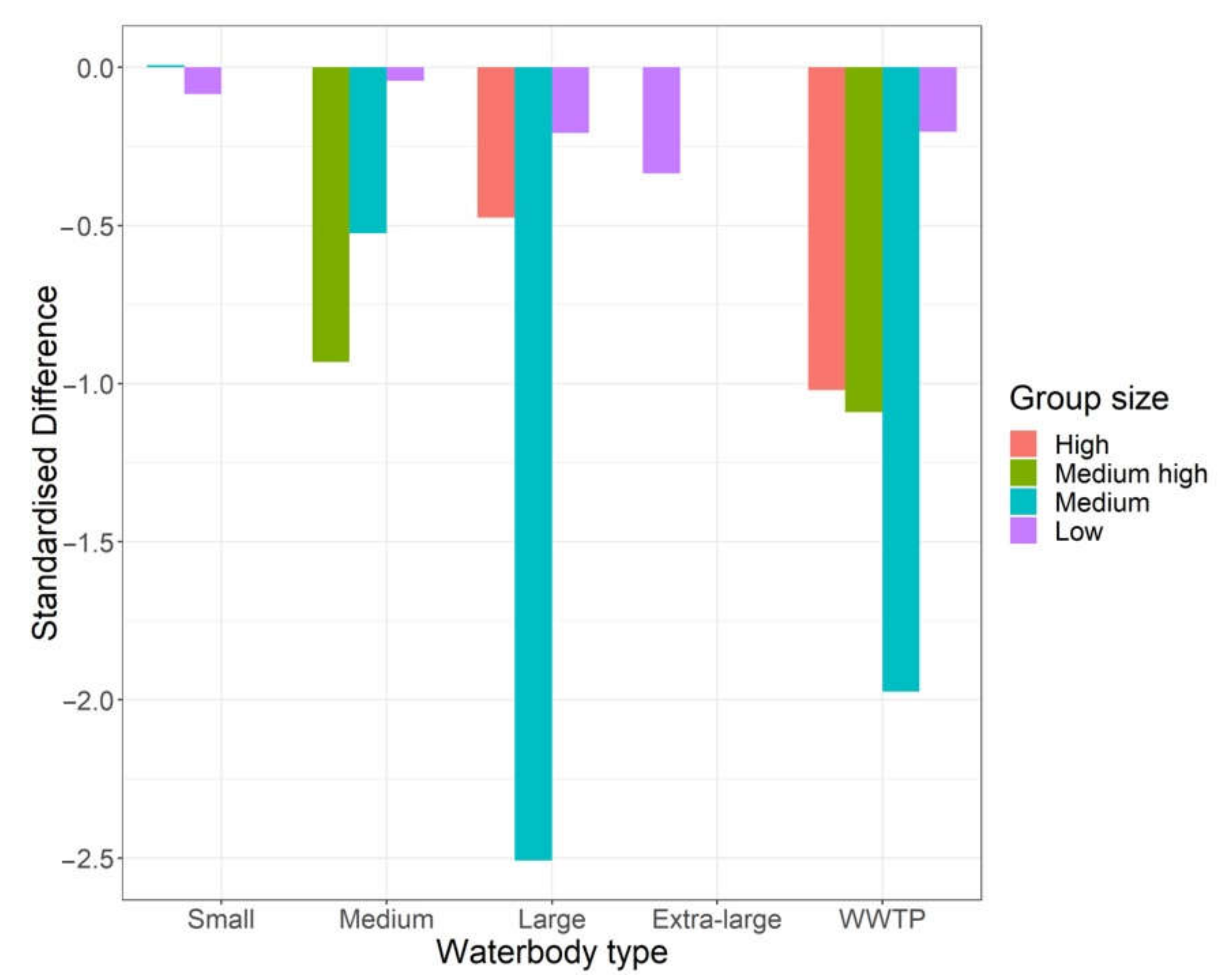
| Group Size | Estimate | SD | Lower 95% CI | Upper 95% CI |
|---|---|---|---|---|
| Low | 0.862 | 1.329 | 0.492 | 1.506 |
| Medium | 0.255 | 1.445 | 0.125 | 0.529 |
| Medium-high | 0.385 | 2.801 | 0.051 | 2.958 |
| High | 0.489 | 2.767 | 0.068 | 3.589 |
| Survey Method: Waterbody Type | Estimate | SD | Lower 95% CI | Upper 95% CI |
|---|---|---|---|---|
| Drone: Small | 0.995 | 1.542 | 0.426 | 2.339 |
| Ground: Small | 1.038 | 1.542 | 0.442 | 2.446 |
| Drone: Medium | 1.013 | 1.534 | 0.430 | 2.354 |
| Ground: Medium | 0.686 | 1.534 | 0.291 | 1.596 |
| Drone: Large | 1.401 | 1.516 | 0.614 | 3.182 |
| Ground: Large | 0.833 | 1.516 | 0.364 | 1.892 |
| Drone: Extra-large | 1.145 | 1.757 | 0.369 | 3.514 |
| Ground: Extra-large | 0.876 | 1.759 | 0.281 | 2.690 |
| Drone: WWTP | 1.509 | 1.519 | 0.664 | 3.425 |
| Ground: WWTP | 0.796 | 1.520 | 0.350 | 1.809 |
| Species | Estimate | SD | Lower 95% CI | Upper 95% CI |
|---|---|---|---|---|
| Grey Teal | 0.612 | 1.025 | 0.582 | 0.643 |
| Australian Wood Duck | 0.687 | 1.094 | 0.575 | 0.821 |
| Pacific Black Duck | 0.809 | 1.038 | 0.751 | 0.871 |
| Hardhead | 1.153 | 1.105 | 0.947 | 1.405 |
| Pink-eared Duck | 0.664 | 1.129 | 0.522 | 0.843 |
| Chestnut Teal | 1.536 | 1.250 | 0.994 | 2.391 |
| Australasian Shelduck | 1.037 | 1.143 | 0.795 | 1.350 |
| Blue-winged Shoveler | 0.379 | 1.277 | 0.232 | 0.605 |
| Plumed Whistling Duck | 0.567 | 1.031 | 0.533 | 0.603 |
Publisher’s Note: MDPI stays neutral with regard to jurisdictional claims in published maps and institutional affiliations. |
© 2021 by the authors. Licensee MDPI, Basel, Switzerland. This article is an open access article distributed under the terms and conditions of the Creative Commons Attribution (CC BY) license (http://creativecommons.org/licenses/by/4.0/).
Share and Cite
Dundas, S.J.; Vardanega, M.; O’Brien, P.; McLeod, S.R. Quantifying Waterfowl Numbers: Comparison of Drone and Ground-Based Survey Methods for Surveying Waterfowl on Artificial Waterbodies. Drones 2021, 5, 5. https://doi.org/10.3390/drones5010005
Dundas SJ, Vardanega M, O’Brien P, McLeod SR. Quantifying Waterfowl Numbers: Comparison of Drone and Ground-Based Survey Methods for Surveying Waterfowl on Artificial Waterbodies. Drones. 2021; 5(1):5. https://doi.org/10.3390/drones5010005
Chicago/Turabian StyleDundas, Shannon J., Molly Vardanega, Patrick O’Brien, and Steven R. McLeod. 2021. "Quantifying Waterfowl Numbers: Comparison of Drone and Ground-Based Survey Methods for Surveying Waterfowl on Artificial Waterbodies" Drones 5, no. 1: 5. https://doi.org/10.3390/drones5010005
APA StyleDundas, S. J., Vardanega, M., O’Brien, P., & McLeod, S. R. (2021). Quantifying Waterfowl Numbers: Comparison of Drone and Ground-Based Survey Methods for Surveying Waterfowl on Artificial Waterbodies. Drones, 5(1), 5. https://doi.org/10.3390/drones5010005


