Spatio-Temporal Change Monitoring of Outside Manure Piles Using Unmanned Aerial Vehicle Images


Abstract
:1. Introduction
2. Materials and Methods
2.1. Study Area
2.2. UAV Image and OMP Information Collection
2.3. Comparison of UAV-Derived DSM Accuracy of OMP Volumes
3. Results
3.1. Results of UAV Flight Data
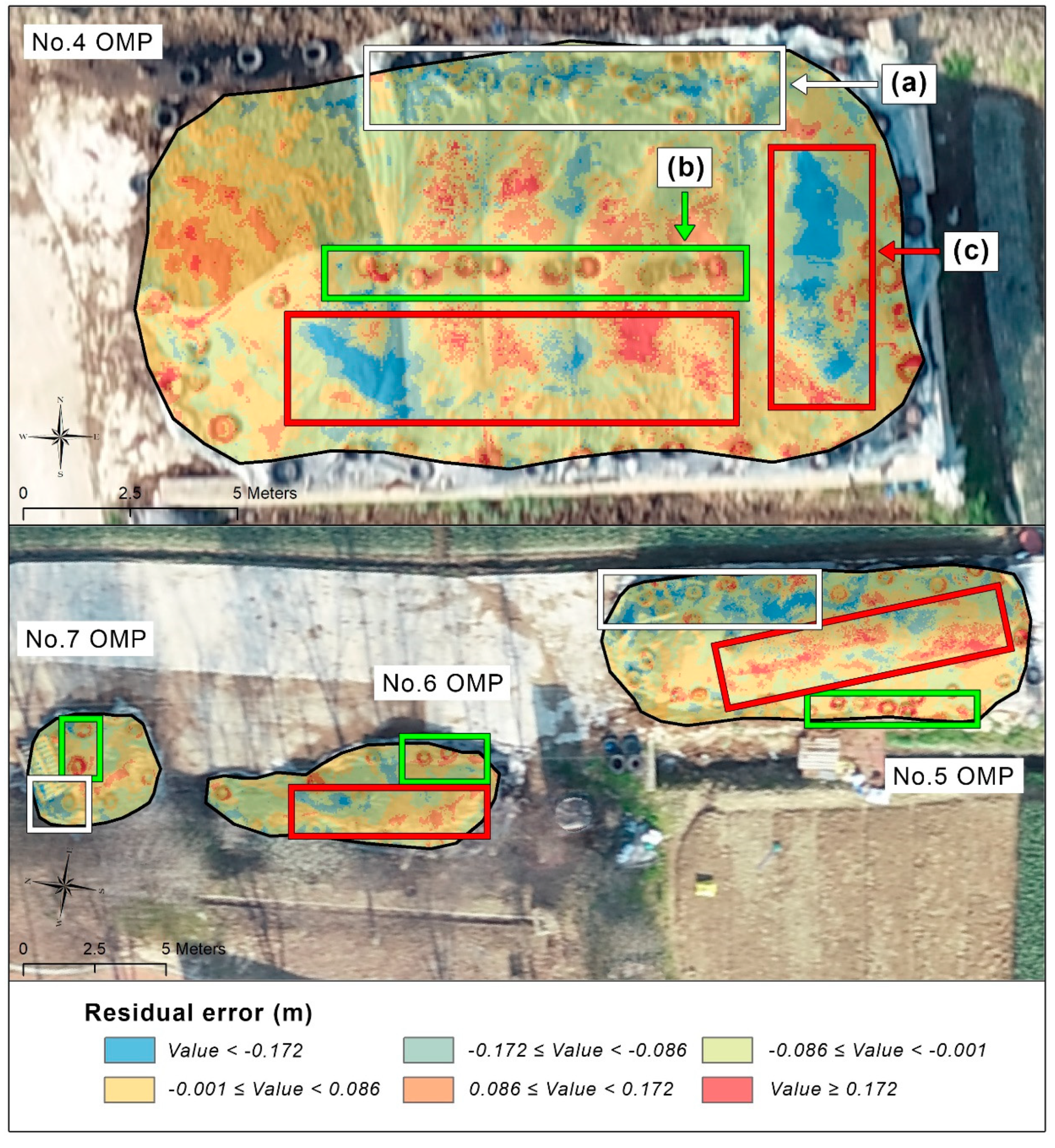
3.2. Accuracy Analysis of OMP Volume from UAV Data
3.3. Spatio-Temporal Changes of OMPs
4. Discussion
5. Conclusions
Author Contributions
Funding
Data Availability Statement
Conflicts of Interest
Appendix A


References
- Ilea, R.C. Intensive livestock farming: Global trends, increased environmental concerns, and ethical solutions. J. Agric. Environ. Ethics 2009, 22, 153–167. [Google Scholar] [CrossRef]
- Zhu, L.D.; Hiltunen, E. Application of livestock waste compost to cultivate microalgae for bioproducts production: A feasible framework. Renew. Sustain. Energy Rev. 2016, 54, 1285–1290. [Google Scholar] [CrossRef]
- Kumar, R.R.; Park, B.J.; Cho, J.Y. Application and environmental risks of livestock manure. J. Korean Soc. Appl. Biol. Chem. 2013, 56, 497–503. [Google Scholar] [CrossRef]
- Sharpley, A.; Moyer, B. Phosphorus Forms in Manure and Compost and Their Release during Simulated Rainfall. J. Environ. Qual. 2000, 29, 1462–1469. [Google Scholar] [CrossRef]
- Viman, O.V.; Oroian, I.; Fleșeriu, A. Types of water pollution: Point source and nonpoint source. AACL Bioflux 2010, 3, 393–397. [Google Scholar]
- He, C.; DeMarchi, C.; Tao, W.; Johengen, T.H. Modeling Distribution of Point and Nonpoint Sources Pollution Loadings in the Saginaw Bay Watersheds, Michigan. Geospat. Tools Urban Water Resour. 2013, 97–113. [Google Scholar] [CrossRef]
- Jung, E.S.; Kim, G.B.; Kim, H.J.; Jang, K.M.; Park, J.S.; Kim, Y.J.; Hong, S.C. A Preliminary Study on Livestock Wastewater Treatment by Electrolysis and Electro-coagulation Processes using Renewable Energy. J. Korean Soc. Urban Environ. 2017, 17, 43–50. [Google Scholar]
- Park, G.; Park, K.; Song, B.; Moon, B. Monitoring of non-point Pollutant Sources: Management Status and Load Change of Composting in a Rural Area based on UAV. Korean Assoc. Geogr. Inf. Stud. 2019, 22, 1–14. [Google Scholar]
- Henderson, F.M.; Hart, T.F.; Orlando, L.; Heaton, B.; Portolese, J.; Chasan, R. Application of C-CAP protocol land-cover data to nonpoint source water pollution potential spatial models in a coastal environment. Photogramm. Eng. Remote Sens. 1998, 64, 1015–1020. [Google Scholar]
- Ritchie, J.C.; Cooper, C.M. Remote sensing techniques for determining water quality: Applications to tmdls. In Proceedings of the TMDL Science Issues Conference, Water Environment Federation, Alexandria, VA, USA, 4–7 March 2001; pp. 367–374. [Google Scholar]
- Ritchie, J.C.; Zimba, P.V.; Everitt, J.H. Remote Sensing Techniques to Assess Water Quality/Técnicas de teledetección para evaluar la calidad del agua. Photogramm. Eng. Remote Sens. 2003, 69, 695–704. [Google Scholar] [CrossRef] [Green Version]
- Shan, N.; Ruan, X.; Ao, J. RS and GIS based temporal-spatial variation and multi-factor spatial analysis on nonpoint source pollution. In Proceedings of the 2010 18th International Conference on Geoinformatics, Beijing, China, 18–20 June 2010; pp. 1–4. [Google Scholar] [CrossRef]
- Gholizadeh, M.H.; Melesse, A.M.; Reddi, L. A comprehensive review on water quality parameters estimation using remote sensing techniques. Sensors 2016, 16, 1298. [Google Scholar] [CrossRef] [PubMed] [Green Version]
- Ning, S.K.; Chang, N.B.; Jeng, K.Y.; Tseng, Y.H. Soil erosion and non-point source pollution impacts assessment with the aid of multi-temporal remote sensing images. J. Environ. Manag. 2006, 79, 88–101. [Google Scholar] [CrossRef] [PubMed]
- Langner, A.; Miettinen, J.; Siegert, F. Land cover change 2002-2005 in Borneo and the role of fire derived from MODIS imagery. Glob. Chang. Biol. 2007, 13, 2329–2340. [Google Scholar] [CrossRef]
- Verbesselt, J.; Hyndman, R.; Newnham, G.; Culvenor, D. Detecting trend and seasonal changes in satellite image time series. Remote Sens. Environ. 2010, 114, 106–115. [Google Scholar] [CrossRef]
- Scaioni, M.; Longoni, L.; Melillo, V.; Papini, M. Remote sensing for landslide investigations: An overview of recent achievements and perspectives. Remote Sens. 2014, 6, 9600–9652. [Google Scholar] [CrossRef] [Green Version]
- Van Iersel, W.; Straatsma, M.; Addink, E.; Middelkoop, H. Monitoring height and greenness of non-woody floodplain vegetation with UAV time series. ISPRS J. Photogramm. Remote Sens. 2018. [Google Scholar] [CrossRef]
- Song, B.; Park, K. Detection of Aquatic Plants Using Multispectral UAV Imagery and Vegetation Index. Remote Sens. 2020, 12, 387. [Google Scholar] [CrossRef] [Green Version]
- Siebert, S.; Teizer, J. Mobile 3D mapping for surveying earthwork projects using an Unmanned Aerial Vehicle (UAV) system. Autom. Constr. 2014, 41, 1–14. [Google Scholar] [CrossRef]
- Nakdong River System Management Committee. Drone-Based Investigation Method for Non-Point Source Pollution Including Agricultural Compost, 2st year Report ed; Nakdong River System Management Committee: Changwon, Korea, 2019. [Google Scholar]
- Martínez-Carricondo, P.; Agüera-Vega, F.; Carvajal-Ramírez, F.; Mesas-Carrascosa, F.J.; García-Ferrer, A.; Pérez-Porras, F.J. Assessment of UAV-photogrammetric mapping accuracy based on variation of ground control points. Int. J. Appl. Earth Obs. Geoinf. 2018, 72, 1–10. [Google Scholar] [CrossRef]
- Dall’Asta, E.; Forlani, G.; Roncella, R.; Santise, M.; Diotri, F.; Morra di Cella, U. Unmanned Aerial Systems and DSM matching for rock glacier monitoring. ISPRS J. Photogramm. Remote Sens. 2017, 127, 102–114. [Google Scholar] [CrossRef]
- Reshetyuk, Y.; Mårtensson, S.G. Generation of Highly Accurate Digital Elevation Models with Unmanned Aerial Vehicles. Photogramm. Rec. 2016, 31, 143–165. [Google Scholar] [CrossRef]
- Grussenmeyer, P.; Landes, T.; Voegtle, T.; Ringle, K. Comparison methods of terrestrial laser scanning, photogrammetry and tacheometry data for recording of cultural heritage buildings. In Proceedings of the International Archives of the Photogrammetry, Remote Sensing and Spatial Information Sciences—ISPRS Archives, Beijing, China, 3–11 July 2008. [Google Scholar]
- Nex, F.; Remondino, F. UAV for 3D mapping applications: A review. Appl. Geomat. 2014, 6, 1–15. [Google Scholar] [CrossRef]
- Rock, G.; Ries, J.B.; Udelhoven, T. Sensitivity analysis of UAV-photogrammetry for creating Digital Elevation Models (DEM). In Proceedings of the International Archives of the Photogrammetry, Remote Sensing and Spatial Information Sciences, Zurich, Switzerland, 14–16 September 2011. [Google Scholar] [CrossRef] [Green Version]
- Harwin, S.; Lucieer, A. Assessing the accuracy of georeferenced point clouds produced via multi-view stereopsis from Unmanned Aerial Vehicle (UAV) imagery. Remote Sens. 2012, 4, 1573–1599. [Google Scholar] [CrossRef] [Green Version]
- Naumann, M.; Geist, M.; Bill, R.; Niemeyer, F.; Grenzdörffer, G. Accuracy Comparison of Digital Surface Models Created By Unmanned Aerial Systems Imagery and Terrestrial Laser Scanner. In Proceedings of the International Archives of the Photogrammetry, Remote Sensing and Spatial Information Sciences, Rostock, Germany, 4–6 September 2013; Volume XL-1/W2, pp. 281–286. [Google Scholar] [CrossRef] [Green Version]
- Santise, M.; Fornari, M.; Forlani, G.; Roncella, R. Evaluation of dem generation accuracy from UAS imagery. In Proceedings of the International Archives of the Photogrammetry, Remote Sensing and Spatial Information Sciences, Riva del Garda, Italy, 23–25 June 2014; pp. 529–536. [Google Scholar]
- Honkavaara, E.; Saari, H.; Kaivosoja, J.; Pölönen, I.; Hakala, T.; Litkey, P.; Mäkynen, J.; Pesonen, L. Processing and assessment of spectrometric, stereoscopic imagery collected using a lightweight UAV spectral camera for precision agriculture. Remote Sens. 2013, 5, 5006–5039. [Google Scholar] [CrossRef] [Green Version]
- Gevaert, C.M.; Suomalainen, J.; Tang, J.; Kooistra, L. Generation of spectral-temporal response surfaces by combining multispectral satellite and hyperspectral uav imagery for precision agriculture applications. IEEE J. Sel. Top. Appl. Earth Obs. Remote Sens. 2015, 8, 3140–3146. [Google Scholar] [CrossRef]
- Tomic, T.; Schmid, K.; Lutz, P.; Domel, A.; Kassecker, M.; Mair, E.; Grixa, I.; Ruess, F.; Suppa, M.; Burschka, D. Toward a fully autonomous UAV: Research platform for indoor and outdoor urban search and rescue. IEEE Robot. Autom. Mag. 2012, 19, 46–56. [Google Scholar] [CrossRef] [Green Version]
- Kerkech, M.; Hafiane, A.; Canals, R. Deep leaning approach with colorimetric spaces and vegetation indices for vine diseases detection in UAV images. Comput. Electron. Agric. 2018, 155, 237–243. [Google Scholar] [CrossRef]
- Su, J.; Liu, C.; Coombes, M.; Hu, X.; Wang, C.; Xu, X.; Li, Q.; Guo, L.; Chen, W.H. Wheat yellow rust monitoring by learning from multispectral UAV aerial imagery. Comput. Electron. Agric. 2018, 155, 157–166. [Google Scholar] [CrossRef]
- Koparan, C.; Koc, A.B.; Privette, C.V.; Sawyer, C.B. In situ water quality measurements using an unmanned aerial vehicle (UAV) system. Water 2018, 10, 264. [Google Scholar] [CrossRef] [Green Version]
- Su, T.C. A study of a matching pixel by pixel (MPP) algorithm to establish an empirical model of water quality mapping, as based on unmanned aerial vehicle (UAV) images. Int. J. Appl. Earth Obs. Geoinf. 2017, 58, 213–224. [Google Scholar] [CrossRef]
- PIX4D Mobile Application User Manual of PIX4D Capture Webpage. Available online: https://support.pix4d.com/hc/en-us/articles/360019848872-Android-Pix4Dcapture-Manual-and-Settings (accessed on 4 February 2020).
- DJI Phantom 4 Specs. Available online: https://www.dji.com/phantom-4/info (accessed on 4 April 2020).
- Tilly, N.; Kelterbaum, D.; Zeese, R. Geomorphological mapping with terrestrial laser scanning and uav-based imaging. Int. Arch. Photogramm. Remote Sens. Spat. Inf. Sci. 2016, 41, 591–597. [Google Scholar] [CrossRef]
- Ouédraogo, M.M.; Degré, A.; Debouche, C.; Lisein, J. The evaluation of unmanned aerial system-based photogrammetry and terrestrial laser scanning to generate DEMs of agricultural watersheds. Geomorphology 2014, 214, 339–355. [Google Scholar] [CrossRef]
- Coveney, S.; Stewart Fotheringham, A.; Charlton, M.; McCarthy, T. Dual-scale validation of a medium-resolution coastal DEM with terrestrial LiDAR DSM and GPS. Comput. Geosci. 2010, 36, 489–499. [Google Scholar] [CrossRef]
- Guarnieri, A.; Vettore, A.; Pirotti, F.; Menenti, M.; Marani, M. Retrieval of small-relief marsh morphology from Terrestrial Laser Scanner, optimal spatial filtering, and laser return intensity. Geomorphology 2009, 113, 12–20. [Google Scholar] [CrossRef]
- Tarolli, P. High-resolution topography for understanding Earth surface processes: Opportunities and challenges. Geomorphology 2014, 216, 295–312. [Google Scholar] [CrossRef]
- Eltner, A.; Baumgart, P. Accuracy constraints of terrestrial Lidar data for soil erosion measurement: Application to a Mediterranean field plot. Geomorphology 2015, 245, 243–254. [Google Scholar] [CrossRef]
- Barneveld, R.J.; Seeger, M.; Maalen-Johansen, I. Assessment of terrestrial laser scanning technology for obtaining high-resolution DEMs of soils. Earth Surf. Process. Landf. 2013, 38, 90–94. [Google Scholar] [CrossRef]
- Buckley, S.J.; Howell, J.A.; Enge, H.D.; Kurz, T.H. Terrestrial laser scanning in geology: Data acquisition, processing and accuracy considerations. J. Geol. Soc. Lond. 2008, 165, 625–638. [Google Scholar] [CrossRef]
- RIEGL Datasheet RIEGL VZ-400i. Available online: http://www.riegl.com/nc/products/terrestrial-scanning/produktdetail/product/scanner/48/ (accessed on 2 February 2020).
- RIEGL Datasheet RiSCAN PRO. Available online: http://www.riegl.com/products/software-packages/riscan-pro/ (accessed on 2 February 2020).
- Kar, S.K.; Ha, K.J. Characteristic differences of rainfall and cloud-to-ground lightning activity over South Korea during the summer monsoon season. Mon. Weather Rev. 2003, 131, 2312–2323. [Google Scholar] [CrossRef]
- Wang, B.; Jhun, J.G.; Moon, B.K. Variability and Singularity of Seoul, South Korea, Rainy Season (1778–2004). J. Clim. 2007, 20, 2572–2580. [Google Scholar] [CrossRef] [Green Version]
- Fulhage, C.D. Land Application Considerations for Animal Manure; MU Extension; University of Missouri: Columbia, MO, USA, 2000. [Google Scholar]
- Sweeten, J.M.; Auvermann, B.W. Composting manure and sludge. Tex. FARMER Collect. 2008, L–2289, 1–7. [Google Scholar] [CrossRef] [Green Version]
- Kapkiyai, J.J.; Karanja, N.K.; Qureshi, J.N.; Smithson, P.C.; Woomer, P.L. Soil organic matter and nutrient dynamics in a Kenyan nitisol under long-term fertilizer and organic input management. Soil Biol. Biochem. 1999, 31, 1773–1782. [Google Scholar] [CrossRef]
- Agbenin, J.O.; Goladi, J.T. Carbon, nitrogen and phosphorus dynamics under continuous cultivation as influenced by farmyard manure and inorganic fertilizers in the savanna of northern Nigeria. Agric. Ecosyst. Environ. 1997, 63, 17–24. [Google Scholar] [CrossRef]
- Karlen, D.L.; Mausbach, M.J.; Doran, J.W.; Cline, R.G.; Harris, R.F.; Schuman, G.E. Soil Science Society of America Soil quality: A concept, definition, and framework for evaluation. Soil Sci. Soc. Am. J. 1997, 61, 4–10. [Google Scholar] [CrossRef] [Green Version]
- Zou, L.; Liu, Y.; Wang, Y.; Hu, X. Assessment and analysis of agricultural non-point source pollution loads in China: 1978–2017. J. Environ. Manag. 2020, 263, 110400. [Google Scholar] [CrossRef] [PubMed]
- Carey, R.O.; Migliaccio, K.W.; Li, Y.; Schaffer, B.; Kiker, G.A.; Brown, M.T. Land use disturbance indicators and water quality variability in the Biscayne Bay Watershed, Florida. Ecol. Indic. 2011, 11, 1093–1104. [Google Scholar] [CrossRef]
- Carey, R.O.; Hochmuth, G.J.; Martinez, C.J.; Boyer, T.H.; Dukes, M.D.; Toor, G.S.; Cisar, J.L. Evaluating nutrient impacts in urban watersheds: Challenges and research opportunities. Environ. Pollut. 2013, 173, 138–149. [Google Scholar] [CrossRef]
- Morse, B.S.; Engh, C.H.; Goodrich, M.A. UAV video coverage quality maps and prioritized indexing for wilderness search and rescue. In Proceedings of the 2010 5th ACM/IEEE International Conference on Human-Robot Interaction (HRI), Osaka, Japan, 2–5 March 2010; pp. 227–234. [Google Scholar] [CrossRef] [Green Version]
- Templin, T.; Popielarczyk, D.; Kosecki, R. Application of Low-Cost Fixed-Wing UAV for Inland Lakes Shoreline Investigation. Pure Appl. Geophys. 2018, 175, 3263–3283. [Google Scholar] [CrossRef] [Green Version]
- Suicmez, E.C.; Kutay, A.T. Optimal path tracking control of a quadrotor UAV. In Proceedings of the 2014 International Conference on Unmanned Aircraft Systems (ICUAS), Orlando, FL, USA, 27–30 May 2014; pp. 115–125. [Google Scholar] [CrossRef]
- Lu, B.; He, Y. Species classification using Unmanned Aerial Vehicle (UAV)-acquired high spatial resolution imagery in a heterogeneous grassland. ISPRS J. Photogramm. Remote Sens. 2017, 128, 73–85. [Google Scholar] [CrossRef]
- Chen, Y.; Zhang, H.; Xu, M. The coverage problem in UAV network: A survey. In Proceedings of the 5th International Conference on Computing, Communications and Networking Technologies (ICCCNT), Hefei, China, 11–13 July 2014; pp. 1–5. [Google Scholar] [CrossRef]
- Idries, A.; Mohamed, N.; Jawhar, I.; Mohamed, F.; Al-Jaroodi, J. Challenges of developing UAV applications: A project management view. In Proceedings of the 2015 International Conference on Industrial Engineering and Operations Management (IEOM), Dubai, UAE, 3–5 March 2015; pp. 1–10. [Google Scholar] [CrossRef]


| Month | April | May | June | August | September | October | |
|---|---|---|---|---|---|---|---|
| Number of OMP Sites | Total | 19 | 23 | 22 | 21 | 22 | 18 |
| Disappeared | - | - | 1 | 2 | 1 | 7 | |
| Created | - | 4 | - | 1 | 2 | 3 | |
| Cover Installation Status | Type A | 68.40% | 69.60% | 86.40% | 81.00% | 81.80% | 22.20% |
| Type B | 15.80% | 8.70% | 13.60% | 9.50% | 9.10% | 33.30% | |
| Type C | 15.80% | 21.70% | 0.00% | 9.50% | 9.10% | 44.40% | |
| OMP ID | Residual Error | Volume (m3) | ||
|---|---|---|---|---|
| Mean (m) | Standard Deviation (m) | TLS | UAV | |
| 5 | −0.001 | 0.086 | 238.19 | 228.69 |
| 6 | −0.002 | 0.078 | 79.92 | 77.5 |
| 7 | −0.001 | 0.086 | 18.16 | 16.37 |
| 8 | −0.001 | 0.086 | 8.748 | 7.61 |
| OMP ID | Volume (m3) | ||||||
|---|---|---|---|---|---|---|---|
| 12 April | 10 May | 25 June | 10 August | 29 September | 26 October | Mean | |
| 1 | 228.14 | 490.07 | 251.21 | 355.39 | 227.43 | 68.87 | 270.19 |
| 2 | 5.43 | 35.45 | - | 13.05 | 14.71 | - | 11.44 |
| 3 | 152.33 | 168.95 | 146.61 | 194.67 | 125.91 | - | 131.41 |
| 4 | - | 33.22 | 25.03 | 12.98 | 14.15 | - | 14.23 |
| 5 | 230.8 | 239.03 | 207.39 | 282.82 | 201.7 | 111.58 | 212.22 |
| 6 | 83.37 | 89.34 | 79.13 | 102.38 | 67.67 | - | 70.32 |
| 7 | 4.54 | 4.94 | 4.25 | 79.3 | 89.89 | - | 30.49 |
| 8 | 4.42 | 5.24 | 5.29 | - | - | - | 2.49 |
| 9 | 164.02 | 156.62 | 165.6 | 259.83 | 170.84 | 134.01 | 175.15 |
| 10 | 38.49 | 36.61 | 33.36 | 44.32 | 115.33 | 110.83 | 63.16 |
| 11 | 89.88 | 106.19 | 189.72 | 254.77 | 176.37 | - | 136.16 |
| 12 | 271.26 | 290.69 | 244.26 | 345.34 | 253.92 | 103.34 | 251.47 |
| 13 | 130.43 | 133.82 | 108.93 | 155.08 | 111.37 | 104.44 | 124.01 |
| 14 | 21.24 | 20.08 | 18.94 | 174.45 | 117.01 | 109.81 | 76.92 |
| 15 | - | 102.79 | 133.35 | 191.13 | 120.68 | 110.36 | 109.72 |
| 16 | 43.18 | 43.76 | 44.97 | 78.51 | 64.66 | 17.5 | 48.76 |
| 17 | 22.59 | 55.69 | 46.63 | 109.04 | 153.97 | 93.48 | 80.23 |
| 18 | - | 117.1 | 96.07 | 182.36 | - | - | 65.92 |
| 19 | 87.17 | 101.4 | 89.32 | 65.16 | 60.37 | 38.58 | 73.67 |
| 20 | 48.45 | 56.33 | 51.67 | 73.52 | 51.99 | - | 46.99 |
| 21 | 40.13 | 140.16 | 69.02 | 134.2 | 74.19 | 34.13 | 81.97 |
| 22 | 38.99 | 40.4 | 56.77 | - | - | - | 22.69 |
| 23 | - | 32.18 | 17.52 | 35.27 | 12.67 | 15.1 | 18.79 |
| 24 | - | - | - | - | 7.84 | 4.04 | 1.98 |
| 25 | - | - | - | - | 45.98 | 17.68 | 10.61 |
| 26 | - | - | - | - | - | 21.11 | 3.52 |
| 27 | - | - | - | - | - | 45.54 | 7.59 |
| 28 | - | - | - | - | - | 27.68 | 4.61 |
| Mean | 89.73 | 108.7 | 94.77 | 149.69 | 103.58 | 64.89 | |
Publisher’s Note: MDPI stays neutral with regard to jurisdictional claims in published maps and institutional affiliations. |
© 2020 by the authors. Licensee MDPI, Basel, Switzerland. This article is an open access article distributed under the terms and conditions of the Creative Commons Attribution (CC BY) license (http://creativecommons.org/licenses/by/4.0/).
Share and Cite
Park, G.; Park, K.; Song, B. Spatio-Temporal Change Monitoring of Outside Manure Piles Using Unmanned Aerial Vehicle Images. Drones 2021, 5, 1. https://doi.org/10.3390/drones5010001
Park G, Park K, Song B. Spatio-Temporal Change Monitoring of Outside Manure Piles Using Unmanned Aerial Vehicle Images. Drones. 2021; 5(1):1. https://doi.org/10.3390/drones5010001
Chicago/Turabian StylePark, Geonung, Kyunghun Park, and Bonggeun Song. 2021. "Spatio-Temporal Change Monitoring of Outside Manure Piles Using Unmanned Aerial Vehicle Images" Drones 5, no. 1: 1. https://doi.org/10.3390/drones5010001
APA StylePark, G., Park, K., & Song, B. (2021). Spatio-Temporal Change Monitoring of Outside Manure Piles Using Unmanned Aerial Vehicle Images. Drones, 5(1), 1. https://doi.org/10.3390/drones5010001