Review

A Comprehensive Review of Applications of Drone Technology in the Mining Industry

1
Department of Mineral Engineering, New Mexico Tech, Socorro, NM 87801, USA
2
Department of Mining Engineering, University of Utah, Salt Lake City, UT 84112, USA
3
Department of Mechanical Engineering, New Mexico Tech, Socorro, NM 87801, USA
*
Author to whom correspondence should be addressed.
Drones 2020, 4(3), 34; https://doi.org/10.3390/drones4030034
Submission received: 4 June 2020 / Revised: 12 July 2020 / Accepted: 13 July 2020 / Published: 15 July 2020

Abstract

:
This paper aims to provide a comprehensive review of the current state of drone technology and its applications in the mining industry. The mining industry has shown increased interest in the use of drones for routine operations. These applications include 3D mapping of the mine environment, ore control, rock discontinuities mapping, postblast rock fragmentation measurements, and tailing stability monitoring, to name a few. The article offers a review of drone types, specifications, and applications of commercially available drones for mining applications. Finally, the research needs for the design and implementation of drones for underground mining applications are discussed.

1. Introduction

Drones, including unmanned air vehicles (UAVs) and micro air vehicles (MAVs), have been used for a variety of civilian and military applications and missions. These unmanned flying systems are able to carry different sensors based on the type of their missions, such as acoustic, visual, chemical, and biological sensors. To enhance the performance and efficiency of drones, researchers have focused on the design optimization of drones that has resulted in the development and fabrication of various types of aerial vehicles with diverse capabilities.
The use of aerial vehicles for industrial applications goes back to the 19th century. In 1860, balloons were used to take pictures for remote sensing purposes [1]. In 1903, pigeons carrying a breast-mounted aerial camera were used for photography [2]. Around the beginnings of World War I, aerial torpedoes, which are known as the origin of drones, were developed [3,4]. In recent years, attention to research and development of unmanned aerial vehicles has been growing by academic and industry communities worldwide [5,6].
Depending on the defined mission, drones are generally classified widely based upon their configurations [6]. Drones can be grouped into nine categories, such as fixed-wing, flapping wing, rotary-wing, tilt-rotor, ducted fan, helicopter, ornithopter, and unconventional types [6].
Drones have a variety of capabilities for both military and civilian utilization [6,7,8,9,10]. These capabilities, along with the demand for unmanned technologies, has resulted in the integration of drones into civil practices [11]. Toward this end, new unmanned aerial vehicles are being developed that can perform various missions in a variety of environments [11,12]. For example, drones are utilized in a vast range of civilian applications such as search and rescue, surveillance, firefighting, weather monitoring, surveying [13], power infrastructure monitoring [14], and urban planning and management [15]. Drones have also been used for building environment monitoring [13] and urban traffic monitoring [16,17], ecological and environmental monitoring [18], species distribution modeling [19], population ecology [19], and ecological monitoring and conservation [20]. Archeology and cultural heritage [21], human and social understanding [22,23], personal and business drones for photography and videography, and even delivery services [13] are other applications of drones. In addition, the unmanned aerial systems have been successfully used in different industries, such as agriculture [24], oil, and gas [25], construction [26], environmental protection [27], mining [18], etc.
Recently the mining industry has shown increased interest in the use of drones for routine operations in surface and underground mines [28,29,30,31,32,33]. This study aims to conduct a review of the application of drone technology in the mining industry. For this purpose, previous studies and information from the companies that provided drones for mining industries are explored. In this paper, the applications of drones in surface and underground mines are reviewed. Applications of drones in surface and underground abandoned mines are also highlighted. Furthermore, the commonly used sensors on mining drones are presented. The challenges in using drone technology in underground mines and potential solutions to those barriers are discussed.

2. Drone Technology Applications in the Mining Industry

There are two main advantages of using drones in mining operations [28]. First, drones equipped with different types of sensors can conduct a quick inspection of an area, either in an emergency situation or hazard identification. Second, inspection and unblocking of blocked box-holes and ore-passes can be done using drones. Drones can also be used for blockage inspection, explosive, and package delivery. Lee and Choi categorized the applications of drones in the mining industry, including surface, underground, and abandoned mines, as demonstrated in Table 1 [18].

3. Applications of Drones in Surface Mining

Generally, mines are located in vast and remote mountainous areas. This makes the monitoring of mines and associated infrastructures a challenging task requiring extensive manpower [23]. Therefore, monitoring mines by traditional methods are time and cost consuming [34]. Appropriately, drones can be beneficial in monitoring, surveying, and mapping of mines’ environment [23]. Drones can be applied to monitor activities in the mines and topography changes of the mining area, which can lead to a guideline for mine planning and safety [23].
For example, in [23], a drone equipped with a hyperspectral frame camera was used to monitor the safety of the production pit [23,35]. In open-pit mines, optimization of slope angle has an important role in production cost reduction, mine efficiency, and recycling resources [36,37]. Tong et al. used integration of terrestrial laser scanning and drone photogrammetry to investigate slope zones by monitoring point displacement and 3D mapping of open-pit slope zones. They also did monitoring for mine inventory and changes in mine area [23,37].
One of the main challenges in the mining industry is collecting geotechnical data from difficult or impossible to access regions [38]. In addition, mapping discontinuity for slope stability could be done by terrestrial LiDAR methodology. However, “shadow zones” or gap in data is repeatedly produced, due to the small scan angle of LiDAR technology [38,39]. However, drones can be utilized to take photos and make measurements by using the analysis of overlapping photographs [39,40]. McLeod et al., in 2013, did an investigation in an open-pit mine to find the direction of discontinuity on the surface of rock slope by using drones topographical survey [29].
Another challenge in the mining industry is mapping engineering geology of the site. Engineering geology covers mapping outcrops, strikes, dips, features notation, and names that bring about the characterization of the site [41]. Drones are able to take detailed images from outcrops [41,42,43]. Nevertheless, most of the time, the results need to be checked by a human survey [41,44]. New algorithms in image processing allow one to identify the type of rocks, strike, faults, and dips which decrease the manual workload significantly [41,45,46,47,48].
One of the activities that is normally repeated in the mining industry is blasting. Blasting is always involved with safety risks, which could be inspected by drones [33]. Important parameters in blasting design are rock type, geology, topography, geometry, borehole location, etc. which can be controlled by drones [49]. In addition, new low-cost data is available by using drones in blasting operations. Medinac et al. used drones to analyze the rock block size before and after blasting [50]. In another case, drones were put to work for monitoring dust particles after blasting operation in an open-pit mine [51].
Additionally, dust particle of mining activity and tailings has a significant environmental issue on the neighboring environment of mine areas, which can be reduced by monitoring and controlling the moisture of the mine and mine tailings [23]. In [52], thermal sensors are installed on drones to capture changes in the spatial and temporal surface moisture content in iron mine tailings. However, analyzing the relationship of moisture content and mine tailings managing could be helpful in mine tailings management [23].
Adopting drones to the mining industry can ease automation by providing visual and various types of sensing data. Considering excellent maneuverability and low-cost and maintenance [30], drones can make a huge benefit to the mine by surveying large areas in a short period of time compared to traditional methods that used the human workforce [53]. They can provide required data where there are health and safety hazards like in slopes [51] or unstable cavities. Therefore, it makes mines a safer workplace compare to the past.
In 2018, Rupprecht and Pieters proposed a drone to fly over the area for reopening of an old abandoned mine in South Africa. The drone was financially evaluated, and its sensitivity and risk were assessed. The used drone was able to take pictures of the whole targeted mine, which also included images of damages and infrastructure [31].
In the University of Queensland, drone technology was used to investigate the characterization of blasting plumes. Drones could measure blasting plumes with a concentration of 1 mg/m3 accuracy. The air quality sensor and autopilot data were integrated to produce an airborne particulates characterization in time and space, which had not been accessed without using a drone. The challenging part of this research was selecting a sensor for dust monitoring using drones [54].
In [29], a drone was used to measure fracture orientation in an open-pit mine. This research was done in three main steps. First, the drone took pictures of the fractures. Second, three dimensional (3D) point cloud (a set of the data point in the space is called point cloud) were produced by using structure from motion (SFM) software. Third, an image processing algorithm was generated to estimate fracture orientation in an open-pit mine. They used a multirotor drone, called Aeryon Scout, to carry a 100-gram camera for taking videos and images.
In 2013 the Aeryon Scout drone was used to obtain a three-dimensional point cloud of the surface mine. In this research, the battery was installed on the top of the drone, and the payload was at the bottom. For navigation system, the drone was equipped with GPS, sonar system for altitudes higher than 2 to 4 meter, pressure altimeter for range altitude that sonar could not support accurately, temperature sensor, a three-axial magnetometer, and a three-axis gyroscope. Collected data were stored in internal storage to be downloaded after the ending the mission. The log file produced by this drone includes the recorded altitude, speed, position (latitude and longitude), and camera orientation (pitch and yaw) [29]. The Aeryon Scout drone was connected to the base station by using a radio modem with a range of 3 km.
In [30], a multihop emergency communication system was proposed to assist the miners and rescue team in emergency situations and improve mining productivity. The idea was to use a drone as a wireless communication framework, which was named SkyHelp, to monitor mining activity and support search and rescue operations in deep open-pit mines. A simulation was carried out by using MATLAB to assess the idea. Table 2 and Figure 1 summarize the characteristics of various types of drones used in surface mines. Table 3 also shows the applications of drones in surface mining.

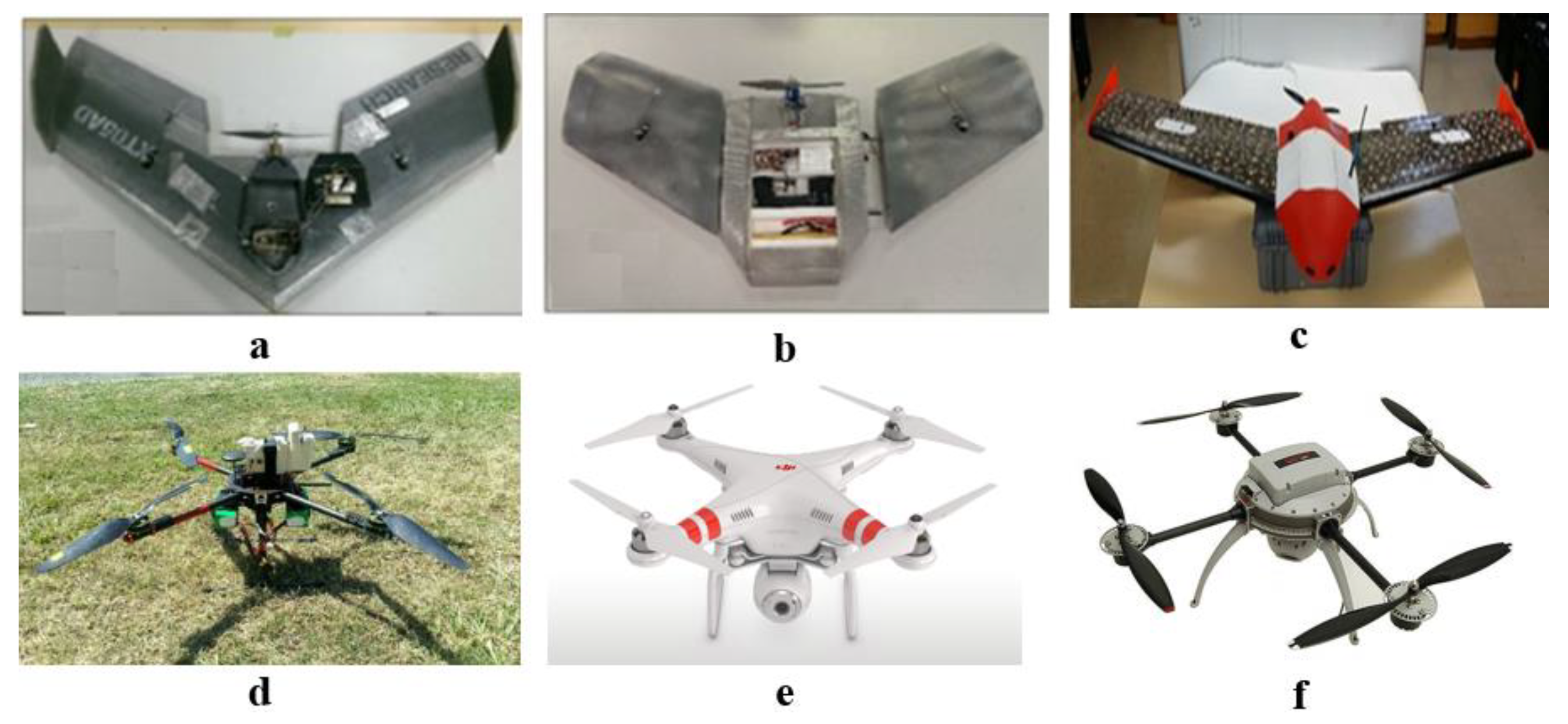
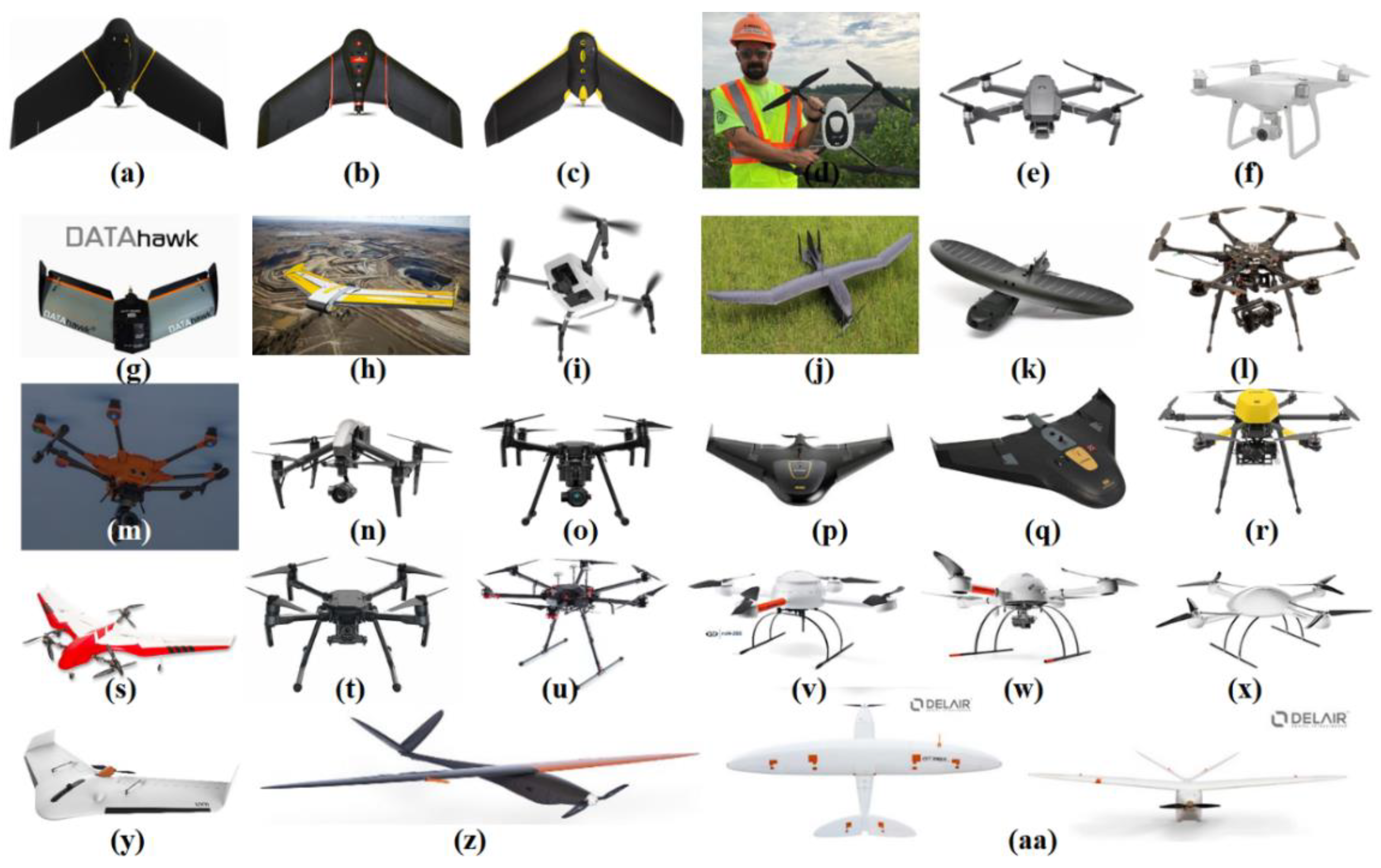
CommerCialized Drones for Surface Mining Applications

Besides the studies and tests carried out by researchers in the application of drones in mining industries, there are some commercialized drones that have been applied by companies for surface mining applications.
SenseFly (Switzerland, 2009): SneseFly is a commercial drone subsidiary of Parrot Group. This company produces both the drone’s hardware and software for aerial data collection and analysis. The general specification of Snesefly products is shown in Table 4. Applications of SenseFly drone are inventory tracking (calculating stockpiles volumes, site surveying), traffic management (haul roads, loading floors and stockpile location optimization, blast planning), water management (accurate management of tailing dams, watersheds, drainage basins assessment and mapping the potential flow of water base on-site current topography), collaboration (improving operational planning, depletion accounting, monitoring environmental factors and making the decision on required maintenance work) [37,38].
Drone Deploy (USA, 2011): The company is a cloud software platform for commercial drones, which is especially compatible with DJI drones. This company provides software for aerial data analysis by drones for a variety of industries, including mining. The software is able to make 3D modeling of the area, contour line map, offline mine inspection, and stockpiles volume calculation. It has been claimed that Drone Deploy customers have mapped and analyzed more than 30 million acres in over 160 countries [39,40].
Kespry (USA, 2013): Kespry Company produces both drone’s hardware and software for application in the mining industry. The drone properties of the Kespry Company are shown in Table 4. The services for the mining industry by Kespry Company include managing waste-rock and ore stockpile inventories, generating cut-and-fill reports for dragline operations, evaluating slope stability on active high-walls, reclamation planning, and verification of blasting pattern locations. The Kespry 2s drone delivers images with the 0.5 cm per pixel resolution. Because of the low flight time of multirotor, Kespry added the ability of field swappable battery on the drone. The obstacle avoidance of this drone is about (50 m) forward-facing by LiDAR sensor [41,42].
Propeller Aero (Australia, 2014): Propeller Aero produces software for aerial data analysis and uses customized DJI’s Phantom 4 Pro (P4P) drone for aerial data collection. The properties of the DJI drones used by Propeller Aero are shown in Table 4. The Propeller Aero package provides a variety of services for the mining industry including: track the status of the mine, volume measurement tools for stockpile and pit volumes, plan blasting and extraction, monitor protected areas and avoid environmental fines, track progress against design, safety inspection, and keeping the haul road grades consistent. The Phantom 4 RTK is able to capture high-quality images with (2.1 cm) total vector distortion. The propeller drone shows the accuracy at or below (3 cm) by using multiple independent checkpoints over the site [43,44].
QuestUAV (United Kingdom, 2012): QuestUAV produces software for aerial data analysis and uses fixed-wing drones for aerial data collection. QuestUAV drone properties are shown in Table 4. These drones assist in a mining operation in a verity of disciplines (see Table 3). The drone has an accuracy of 3.2 cm over areas. Because of difficulty landing fixed-wing drones, a parachute is deployed by QuestUAV for a safe landing. In addition, launching is available by hand, designed air dock, or zip line. In addition, QuestUAV drones allow a series of payloads to be attached to the drone [45].
Skycatch (USA, 2013): Skycatch uses a multirotor drone for aerial data collection, a site base station which uses GPS and GNSS for accuracy in coordinates collection, and software for data management. Explore-1 drone is designed by Skycatch base on DJI Matrice M100 drone and manufactured by DJI Company. The general properties of Explore-1 drone are shown in Table 4. Komatsu Company tried to make the earthwork machine autonomous with Skycatch drone data. They used machine learning and deep learning to find patterns and improve data outputs [46,47].
Prioria (USA, 2003): Prioria was one of the first companies that has provided aerial data for the mining industry. This company produces both drone hardware for aerial data collection and software for data analysis. The general properties of Prioria products are shown in Table 4. These products perform aerial imagery, mapping, stockpile volume calculation, and inspections like pipeline and utility. The fixed-wing drones of this company are hand-launched and tube-launched. The precision of vertical volume calculation is 4 cm and for ground sampling distance it is 1.4 cm [48,49].
3D Robotics (USA, 2009): 3D Robotics produces software for aerial data analysis, which is compatible with Yuneec and DJI drones. The general specification of 3D Robotics drones is shown in Table 4. The available services by 3D Robotics aerial scan are geo-referenced maps and point clouds for mineral exploration, calculating the volumes of individual stockpiles, tracking inventory over time by calculating the volumes of individual stockpiles in every flight, improving site planning and coordination by pre- and postblast surveys, mitigating project risk and remote access to mine information by having near real-time drone and maps and data [50,51].
Trimble (USA, 1978): Trimble Company provides positioning technologies for a variety of industries, such as land survey, construction, agriculture, transportation, telecommunications, asset tracking, mapping, utilities, mobile resource management, and government. However, recently, this company applied drone technology for aerial data collection and analysis. The specifications of the multirotor drones of this company are shown in Table 4. The Trimble drones can provide boundary and topographic surveys, survey-grade mapping, power line modeling, field leveling, site, and route planning, progress monitoring, as-built surveys, resource mapping, disaster analyses, volume determinations, topographic contours, 3D surface models, and orthophotographs for mining industry [52,53].
Precision-hawk (USA, 2011): Precision-hawk offers software for aerial data analysis and uses other company’s drones for aerial data collection. The specifics of DJI multirotor drones and birds-eye-view fixed-wing drone, which is used by Precision-hawk Company, are shown in Table 4. The software of this company provides the volume measurement tools for the pit, stockpile, and similar structure for the mining industry. In addition, outputs of the software could be useful in monitoring, planning, reports, safety and compliance, oversight, and reclamation. This company uses various kinds of sensors on the drones for aerial data collection. Sensors, such as thermal for tracking the relative temperature of the land and objects, multispectral for capturing near-infrared radiation and ultraviolet light which is invisible to human eyes, hyperspectral for identifying minerals, vegetation and other materials, LiDAR for collecting high-quality evaluation of natural and human-made objects, visual for capturing high-resolution aerial images, and video for live streaming and capturing video to on the ground devices can be integrated into the drones [54,55].
Pix4d (Switzerland, 2011): Pix4d uses images taken by drones, hand, or plane for data analysis by using the photogrammetry method. The software of this company is compatible with a variety of drone company products including DJI, Parrot, and 3DR. The services for the mining industry by Pix4d Software Company are as follows: (1) supporting blasting operations by locating boreholes, (2) monitoring blast sites without putting people in danger, (3) measuring stockpile volumes and excavated materials, (4) Pit mapping, and (5) toxic tailing dam mapping. It has been claimed that drone mapping could be performed in 20% of the traditional mapping method time, without disrupting traffic [56,57].
Microdrones (Germany, 2011): Microdrones produces both drones hardware and software for aerial data collection and analysis. The specification of the microdrone is shown in Table 4. The package of drones and software is able to map the deposit site, survey mine, explore minerals, monitor stockpile volume, track equipment, and make time-lapse photography. In addition, sensors like multispectral, thermal, LiDAR, and methane gas detection could be added to the drone for inspection. The drone positioning is carried out by GPS, and the postprocessing of the data method is aerial triangulation [56,57].
Delair (France, 2011): This company creates both software and drone hardware for aerial data analysis and collection. The package of software and drone of this company can provide stockpile volume, contour maps of the pit, finding potential hazards, detecting anomalies and doing the topography survey in the field without interrupting operation. Freeport-McMoRan, one of the largest American copper and gold mining company, used the DT18 Mapper drone package of Delair Company to do weekly topographical surveys for calculating the production capacity and creating digital surface models of the copper mine at Tenke Fungurume (TFM) in the Katanga Province of the Democratic Republic of Congo [58,59].
Table 4 and Figure 2 show the general specifications of commercial drones, including drone type, size, weight, endurance, payload, speed, wind speed resistance, and model name for use in the mining industry.
Table 4. General specifications of commercial drones for use in the mining industry [38,40,42,44,47,49,51,53,55,57,59,60,61].
Type of DroneModelCompanyWingspan (mm)Weight (g)Endurance (min)Payload (g)Speed (m/s)
Fixed-wingeBee XSensefly1160140090-11–30
Fixed-wingeBee SQSensefly960110055-11–30
Fixed-wingeBee ClassicSensefly110069050-11–25
QuadcopterKespry 2sKespry-200030--
QuadcopterDJI Mavic 2 ProKespry, 3D Robotics35090730-20
QuadcopterDJI Phantom 4 ProPropeller Aero, 3D Robotics3501388 30-20
Fixed-wingQ-200 SurveyorQuestUAV1950460060590-
Fixed-wingdatahawkQuestUAV1164215045-19
QuadcopterExplore-1Skycatch650360017-17
Fixed-wingLeviathanPrioria2590589790907-
Fixed-wingMavericPrioria749117945–90-13.5
HexacopterHexPrioria800635015-6.2
HexacopterYuneec 3DR3D Robotics-164528-13.5
QuadcopterDJI M200Precision-hawk643614013–24161023
QuadcopterDJI Inspire 23D Robotics427425032–27-26
HexacopterTrimble ZX5Trimble85050002023009
Fixed-wingTrimble UX5Trimble1000250050-22
Fixed-wingTrimble UX5 Trimble (HP)1000290035-24
Fixed-wingFIREFLY6 PROPrecision-hawk1524450050–5970015–18
QuadcopterDJI M210Precision-hawk643457013–24157024
HexacopterMATRICE 600 Precision-hawk11331000018550018
Quadcoptermd4-200Microdrones540800252508
Quadcoptermd4-1000Microdrones1030265045120012
Quadcoptermd4-3000Microdrones2052600045500020
Fixed-wingUX11Delair1100140059-15
Fixed-wingDT18 HDDelair18002000120-17
Fixed-wingDT26X LiDARDelair330017000110-17
QuadcopterELIOSFlyability40070010-6.5
QuadcopterELIOS2Flyability40055010-4.68

4. Application of Arones in Underground Mines

Despite advancements in drone technology, the use of drones in underground mines has been limited [63]. This is because the application of drones in underground mines is challenging. Harsh underground environments pose many obstacles to flying drones. Confined space, reduced visibility, air velocity, dust concentration, and lack of wireless communication system make it a difficult task for an operator to fly a drone in underground working areas. Furthermore, access to unreachable and dangerous locations in underground mines is practically impossible for a drone operator [63].
Drones in underground mines have numerous potential applications in health and safety. These applications include surface roughness mapping, rock mass stability analysis, ventilation modeling, hazardous gas detection, and leakage monitoring [32,63,64,65,66,67,68].

4.1. Geotechnical Characterization of Underground Mines

Rock mass data collections in underground opening usually require the inspector(s) to survey the rock mass physically. The presence of the personnel in unsupported areas such as open stope and newly blasted working faces endangers the safety of the personnel [69]. Drones are tools that are more suitable to be used in underground mines during the monitoring of unreachable areas. Small size and maneuverability of drones allow them to access hard-to-reach areas in underground mines without endangering the life of the miners. Imagery techniques such as photogrammetry and FLIR (forward-looking infrared) allow characterizing rock masses. Photogrammetry can provide data for generating geological models and structural data for kinematic and numerical analyses. In addition, FLIR imagery can be used to recognize areas of loose rock, which normally remain unnoticed until it becomes a hazard [69].

4.2. Rock Size Distribution Analysis in Underground Mines

The majority of underground hard rock mines use drilling and blasting methods for rock extraction. Assessment of rock size distribution after blasting is an important measurement for next production phases (i.e., loading and hauling) [70,71]. There are some methods for rock size distribution analysis, including visual observation by an expert, sieve analysis, and image processing. Image analysis methods are fast and relatively accurate for rock fragmentation measurements [71,72].

4.3. Gas Detection in Underground Coal Mines

A set of sensors to continuously measure atmospheric parameters and gas concentration will enable a drone to be used for hazardous gas detection in underground mines. Lucila and Masami used an unmanned aerial vehicle for gas detection in underground coal mines [32]. In this research, a gas sensor installed on a drone utilized as a safe and reliable surface measurement of coal fire gases for assessing characteristics of underground coal fires. DJI S1000 Octocopter drone (specification in Table 5) was used for carrying gas sensors. With the combination of this drone and sensor, they could achieve 10 to 15 minutes flight time [32].

4.4. Mine Rescue Mission in Underground Mines

Hoffman and McAllister, in 2018, proposed using an Unmanned Ground Vehicle (UGV) combined with a drone to find the location of trapped workers [73]. The UGV scans the tunnel map during the drive to the destination and provides a variety of information about the conditions of the tunnel. The scenario is that the UGV, which would carry a drone onboard, drives to the location. Then, the drone would launch at the appropriate location to assess the collapsed area and to find any gap through the pile of rock or soil. The role of UGV is to carry the drone, scan the tunnel with a LiDAR sensor, and dock the drone when the mission is completed or drone battery needs recharging [73]. They used a Flame Wheel D JI’s F450 drone as a joint with UGV to carry sensors to the corners of the space that UGV does not access to them. Quadcopter F450 is a multirotor drone designed by the DJI Company. Its takeoff weight is 1600 grams, which is mentioned as a low payload for this kind of mission [73]. Table 5 summarizes the characteristics of various types of drones in underground mines. Figure 3 shows the drones that have been used in underground mines.

4.5. Common Sensing Methods for Drones in Underground Mining

Many sensing technologies are used for underground mining applications, including the stereo camera, ultrasonic sensors, dual redundant IMUs, and infrared sensors used by DJI [36,74]. Ultrasonic sensors are low-cost sensors for obstacle detection that have been tested by several studies. Other kinds of obstacle detector sensors that are repeatedly used by researchers include infrared sensors, stereo cameras, and laser range finders (LRFs) [75,76,77,78,79,80].

4.6. Challenges in Using Drones in Underground Mines

The nature of underground mine environments and other obstacles (e.g., surrounding walls, loose bolt, cables, and equipment) require the drone to be collision tolerant. Ideally, the drone should be able to detect and avoid obstacles during its flight in the indoor environment. Since the underground mine sites are constantly expanding, the coverage area of communication increases as the operation continues [81], which creates a challenge for a drone to cover the entire mine during regular working operation as well as in emergencies [82].
Due to the existence of obstacles in underground mines, the main problem of using drones is signal propagation. There is a need for a radio signal connection between the drone and the remote controller in order to fly the drone. The environment continually absorbs the signal’s energy. Therefore, if a drone flies far in the underground environment, it will lose its signal, and consequently, it is not able to return to the deployment point [83]. To solve this challenge, a transmission system can be integrated into the drone. This is efficient enough to allow the drone to fly far away into the down curved, underground passages and tunnels without loss of signal coverage. It also sends a constant video stream of what the drone camera is recording [83].
The battery life limits the flying time of drones. In many circumstances, battery replacement is required to extend the flying time. The weather situation in underground mines also can affect battery life and safety [84,85]. There are drones that employ hybrid power systems (i.e., batteries plus combustion engine) to perform longer-duration missions [86,87].
Additionally, humidity or water leakage damage the electronic components of the drones and interfere with the communication between the drone and its controller [86,88]. The visibility of people and objects in real-time is important to avoid accidents. However, there are many circumstances in which visibility is not sufficient to proceed with a mission using a drone [63,89].

5. Application of Drone Technology in Abandoned Mines

The website of the Bureau of Land Management reports as of 2016, in the United States, tens of thousands of abandoned mines have been registered [90]. The website also estimates that approximately 500,000 abandoned mines exist in the nation [90]. Abandoned mine lands (AMLs) pose environmental, health, and safety threats to humans [90]. An example is the miners of Somerset, Pennsylvania, who accidentally died by breaching an abandoned flooded mine. The miners were not aware of the existence of the nearby abandoned mine [91,92]. Another example is the existence of “bord and pillar” underground mines in Newcastle (NSW) and Ipswich (QLD) in Australia. The mines are now abandoned and located beneath residential areas, which elevates the risk of ground subsidence [93]. Similarly, subsidence is being monitored for the abandoned gold mines in Nova Scotia and Ontario, Canada and coal mines in Illinois and Ohio, USA [94].
Moreover, when a coal mine is abandoned, the methane emission is reduced but does not completely stop. Abandoned mines can liberate methane at a near-steady rate for an extended period of time. Flooding of the mines can inhibit gas emissions and buildups in the empty spaces; this would also help to mitigate the danger level of working in active mines nearby [95,96]. Therefore, monitoring and mapping abandoned mines are important to decrease the risk of environmental hazards. However, monitoring of such vast areas with the traditional, labor-intensive, expensive monitoring methods is challenging. Drone technology, as a financially efficient approach, can be an alternative solution. Table 6 and Table 7 summarize the applied drone’s missions in abandoned mines.

6. Application of Drones in Search and Rescue Operations

Most of the mines are in a remote area where common, reliable communication systems may not be available. Drones provide rapid solutions in support of communications coverage of rescue operations [112,113]. Drones can provide disaster warnings and assist with accelerating rescue and recovery operations when the communications networks are not serving anymore. Drones also have the capability to carry medical supplies to hard-to-reach areas. In certain circumstances (e.g., poisonous gas infiltration and searching for missing persons), drones can support the role of accelerating these operations [114]. Table 8 shows a few examples of the application of drones in mine rescue missions.

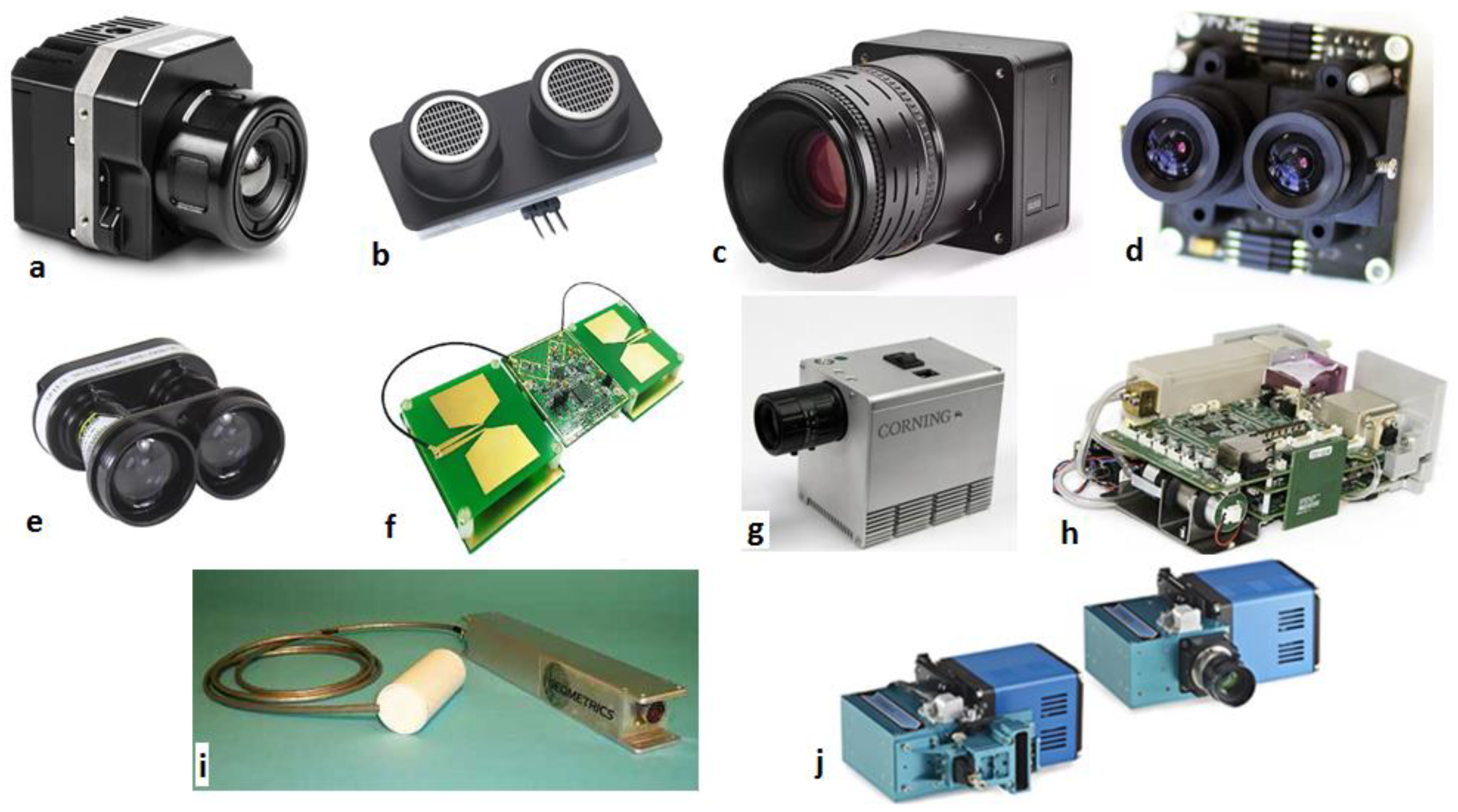
7. Commonly Used Sensors on Mining Drones

Fast technological advancements in both passive and active sensors have empowered the capability of drones in various types of missions [117,118]. Sensors on drones facilitate image capturing at centimeter and spatial resolution and time-dependent resolution at temporal [117,119,120,121,122]. The sensors on a drone depend on drone size and the mission. However, depending on the goal of the aerial investigation and the lighting condition, various kinds of sensors need to be attached to the drone. These include the RGB sensors, ultrasonic sensors, Infrared Sensors (IR), stereo camera, laser range finders (LRFs), Ultra-Wideband Radar (UWB), and hyperspectral sensors. Figure 4 shows examples of commonly used sensors in drones in the mining industry.

7.1. Infrared Sensors (IR)

Infrared Sensors (IR) are a kind of low-cost obstacle detector sensor. Infrared radiation can be either detected or emitted by IR. Generally, all materials above absolute zero emit waves in the infrared spectrum. Infrared sensors, considered as heat sensors, can detect the energy radiation of objects. Despite the limited resolution, infrared sensors have the ability to detect human [75,80,132]. On the one hand, it has the advantage of sensing through fog, smoke, day, and night. However, on the other hand, it can be distorted by flame and any other high-temperature sources. Moreover, it does not work well through thick dust [75,132].

7.2. Ultrasonic Sensors (US)

Being inexpensive and uncomplicated make ultrasonic sensors viable for various applications. These sensors detect the obstacles by radiating high-frequency sound waves and collecting reflected waves. The distance to the obstacles can be determined by considering the time-of-flight technique. An ultrasonic sensor is the only common sensor in the drone technology that is not based on electromagnetic waves (EM). The disadvantage of the ultrasonic sensor is detecting sound-absorbing materials, like cloth, for example. Besides, it has a shorter range than another type of sensors [75,76,80].

7.3. Red-Green-Blue (RGB) Sensors

RGB camera can be used in surveying and mapping, stockpile volume calculation, road traffic monitoring, security monitoring, inspection, etc. RGB camera is a sensing system that takes RGB (Red Green Blue) images, including a per-pixel depth report. RGB cameras work with one of two active stereos [133,134] or time-of-flight sensing to create depth evaluation at a huge number of pixels [133]. Camera selection needs to be done carefully, considering the drone’s fuel consumption. Generally, a compact camera is preferred for fixed-wing drones because heavy devices cannot be carried [18].

7.4. Stereo Cameras

The stereo camera is a kind of camera that is equipped with two or more lenses to create 3D images, similar to the human visual system. Stereo cameras are able to develop three-dimensional images by their separate image sensors. High resolution and accuracy in a clean environment are the advantages of stereo cameras. However, it has poor performance in smoke, fog, or dust, because the light waves are distorted in such conditions [80].

7.5. Laser Range Finders (LRFs)

Laser range finders (LRFs) are expensive sensors commonly used for obstacle detection in drone technology. In LRFs, a laser beam is radiated to an obstacle, and by receiving a reflected wave and considering time-of-flight, the distance to an object can be measured. As LRFs use optical wavelengths of light, it is not suitable for conditions like fog, smoke, dust, or similar adverse conditions [80].

7.6. Ultra-Wideband Radar (UWB)

Obstacles detection by Ultra-Wideband Radar (UWB) is carried out by emitting electromagnetic waves in the radio spectrum. Similar to US and LRFs, the distance to the target can be measured by taking into account the reflected wave and times-of-flight. However, radar’s radio waves have a longer wavelength than visible light and infrared. Therefore, radio waves have better penetration than visible light in the dust, fog, smoke, and other adverse conditions [80,135].
Ultra-Wideband Radar (UWB) has some features that make it suitable for mining drones. First, it has a more precise and higher image resolution compared to the ultrasonic sensors in harsh environmental conditions like fog, smoke, dust, rain, snow, gas, and aerosols [77,80,132]. Second, UWB uses low energy that is generally less than 1 Watt. This means drone battery power can be saved for other utilities [80,136]. Third, regarding low spectral density, UWB has minimum interference with other wireless uses like flight controller and telemetry link [80,136]. Fourth, UWB can detect different characteristics like walls, edges, and corners. Finally, it can identify the three-dimensional coordinates of the nearest object [137].

7.7. Hyperspectral Sensors

Recently, lightweight hyperspectral imaging (HSI) sensors are being developed for use on drones [138,139,140]. Most of the multispectral imagers (Landsat, SPOT, and AVHRR) detect reflectance of Earth’s surface material at several wide wavelength bands which are separated by spectral segments. In other words, hyperspectral sensors assess reflected radiation as a series of narrow and contiguous wavelength bands. Typically, bands are measured at 10 to 20 nm intervals by hyperspectral sensors [141]. These sensors can provide information that is not accessible by traditional methods. In general, this kind of sensor is widely used in geology, mineral mapping, and exploration [140,142,143,144,145].

7.8. Magnetic Sensors

The magnetic sensors produce an accurate measurement of the magnetic field. Moreover, magnetic sensors assess disturbances and changes in the magnetic field include flux, strength, and direction [146]. The normal weight of a Cesium magnetometer, such as the Scintrex CS-3Sl, is about 0.82 kg. It should be noted that for deriving three-dimensional magnetic field gradients, there is a need for four magnetometers. This means 3.28 kg would be the total weight of the Magnetic sensors. This kind of sensor could be useful in mineral exploration [147].

7.9. Visible and Near-Infrared Spectral Range (VNIR

VNIR sensors of the electromagnetic spectrum are usually preferred to be installed on drones due to their small size and low weight. The wavelength at intervals of about 400 and 1400 nanometers (nm) is called the visible and near-infrared (VNIR) portion of the electromagnetic spectrum [148]. This range consists of the complete visible spectrum with an adjacent part of the infrared spectrum up to the water absorption band at intervals 1400 and 1500 nm [149]. In addition, there are some definitions that cover the short-wavelength infrared band from 1400 nm up to the water absorption band at 2500 nm [149]. These sensors could be used for surface moisture of open pits [150], tailing dams, underground spaces wall, and surfaces. In addition, each particulate mineral has a special signature in VNIR spectra [151], which is an advantage in mineral exploration by drones equipped with VNIR sensor.

7.10. Air Quality Sensors

On top of the aforementioned sensors, specific sensors (e.g., air quality, gas sensing, dust monitoring, etc.) can be installed on a drone for a particular mission. Table 9 shows examples of sensors that are used for air quality testing and gas detection. Typically, the air quality sensors are based on optical, ultrasound, and electrochemical sensing elements [35]. These sensors could be handheld personally, installed on the vehicle, or from ground-based network systems. Many of these sensors can be installed on a drone depending on the type of contamination, release time, and measurement requirements. For example, rotary-wings drones have been used to sense water vapor and CO2, CH4 [152], ethanol and CH4 [96,153], NO2 and NH3 [154,155], CO2 [154,156], SO2 [157]. Lega et al. visualized air pollutants in 3D and real-time by using a multirotor drone [158]. Moreover, different types of this platform were used to identify sewage discharges along with Italy coastline by sensing gases include CO, C6H6, NO2, O3, SO2, NOX, and PM10, besides thermal IR images [154,158,159]. At present, fixed-wing drones can stream real-time monitoring as well as supplying indexed-linked samples [154,158].

8. Discussion

8.1. Challenges in Using Drones in the Mining Industry

In surface mines, weather conditions present a challenge by inducing deviations in drone’s predesignated paths compared to underground mines. In some cases, weather conditions can be damaging to the drones, leading to failure in their missions [113,160]. In the mining industry, as well as other industries, energy consumption during a mission can impose many challenges. Normally, drones run on battery and consume the energy for hovering, wireless connection, data, and image processing. Due to the power restrictions as such, a decision needs to be made on whether data and image analysis should be performed onboard in real-time or offline to reduce energy consumption [113,161,162].
In underground mines, confined space, heat and humidity, dusty air and poor lighting conditions are the main issues that mineworkers generally face. Some concepts have been proposed for using drones in underground mines, but usually are applying manual techniques for control and navigation. At a minimum, the designed drone should be capable of fully autonomous navigation in a completely GPS-denied environment and fly in an environment with no lighting other than that provided by the drone. Nature of underground mine environments and other constraints (e.g., surrounding walls, loose bolt, cables, and equipment) require the drone to be collision tolerant. Ideally, the drone should be able to detect and avoid obstacles during its flight in the indoor environment. The drone should also tolerate harsh underground mine environments and fly in heavy dust and smoke. Therefore, the drone should be waterproof, dustproof, shockproof, and should resist pressure, temperature, and humidity changes throughout the mine site. For underground coal mine applications, due to the presence of methane and potential explosion/fire hazards, the battery and the electronic sensors must be insulated. Adding to the above-mentioned requirements, the drone should provide other features, including low power consumption and human body detection.

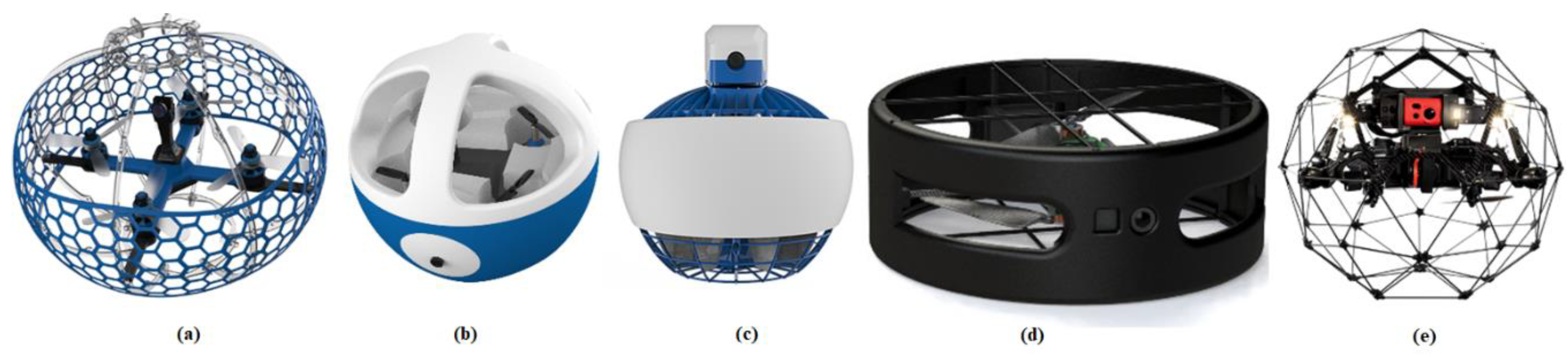
8.2. Suitable Drone Configuration for Underground Mining Applications

As mentioned above, there are some challenges in using drones in underground environments. To this end, there is a need to design an optimized microdrone that can address all of these challenges. The first step in designing a drone is configuration development. Considering an underground mine environment, a drone with hovering capability can be designed. One of the types of microdrones is multirotors, which allow them to fly in confined spaces. These drones, which can hover and have high maneuverability due to rotary blades or propeller-based systems, are called rotary-wing drones. Unlike the fixed-wing models, these drones can fly in every direction, horizontally, vertically, and also can hover in a fixed position. Rotary wing drones, similar to helicopters, generate lift from the constant rotation of the rotor blades. In this type of drone, several blades may be used. Thus, nowadays, researchers designed and fabricated different types of drones ranging from one to twelve motors. These characteristics make them the perfect drones for surveying hard-to-reach areas, such as pipelines, bridges, mines, etc.
Having drones that are confined in boxes is necessary for situations in which the surrounding environments are unknown. To this end, there is a need to design structures to keep the drones safe. Different structural configurations have been proposed in order to be able to use these drones in underground mines, in the wake of natural disasters, and in the presence of people (Figure 5 and Figure 6). The structure around the drones allows safety for the drone, along with allowing the drone to have a rolling feature. The drones, with their encasing optimized structure, have the ability to fly through confined spaces like mines and have the capability to roll on the ground and walls of the mines if needed. Considering the environment, a drone with a flexible spherical structure can be designed, which will be able to fly in high temperatures and dusty air in the mines. In the following, different types of the encased drones are discussed. Table 10 shows examples of encased drones for industrial and research applications.
Figure 5. View of encased drones, (a) Fleye Racer [163], (b)Fleye Helmet [163], (c) Fleye Ducted [163], (d) Flybotix drone [164], and (e) Elios 2 [68].
Drones 04 00034 g005
Table 10. The characteristics of industrial encased drones [68,164,165].
TypeModelGoalCompanyDiameter (mm)Weight (g)Speed (m/s)
Single rotorFleye RacerLearn how to fly a droneFleye11023527
Four propellerFleye HelmetLearn how to fly a droneFleye21021011
Single rotorFleye DuctLearn how to fly a droneFleye1104004
Dual rotorFLYBOTIXIndustrial InspectionFlybotix300--
QuadcopterElios 2Industrial inspectionFlyability40014501.5
Single RotorUFROSearch and rescueOklahoma State University560950-
Encased single-rotorGlimballFlying multiple collisions environmentLaboratory of Intelligent Systems-Switzerland-3851.5
Encased MultirotorPRSS UAVIndoor inspection after the disasterTohoku University
Japan
89419562.5
Encased single-rotorSpherical droneIndoor operationsCranfield University226 (inner)590-
Encased MultirotorSphereflying spherical display surfaceResearch Labs, NTT DOCOMO8804500-
Figure 6. View of encased drones, (a) Spherical Drone [166], (b, c) UFRO [167], (d) Glimball [168], (e, f) PRSS UAV [169], (g) Simha et al.’s Drone [170], (h) Spherical Drone [171], and (i,j) isphere [172].
Drones 04 00034 g006

9. Conclusions

In this paper, recent studies and developed commercial drones and services in the mining industry were discussed. In addition, the drone applications in the mining industry for search and rescue missions were discussed. Besides, common remote sensing tools that have been mounted on drones in the mining industry were reviewed. Drone technology is a common tool in surface mining. It is efficient and low cost compared to the traditional monitoring methods. Drones in surface mining have a variety of applications, such as ore control, rock discontinuities mapping, 3D mapping of the mine environment, blasting management, postblast rock fragmentation measurements, and tailing stability monitoring, to name a few. Fixed-wing and rotary-wings drones are the most commonly used drones in the mining industry, including both research and commercial applications.
Despite significant advancement in drone technology, the applications of drones in underground mines are still limited. This is due to challenges like GPS-denied environments, lack of wireless signal, confined spaces, the concentration of dust and gases, and generally harsh environments. The possible solution for the use of drones in underground mining was suggested. Encased drones can be a solution to the environmental obstacles in underground mine environments.

Author Contributions

Writing—original draft, J.S. and E.T.; Writing—review & editing P.R., and M.H. All authors have read and agreed to the published version of the manuscript.

Funding

This research received no external funding.

Conflicts of Interest

On behalf of all authors, the corresponding author states that there is no conflict of interest.

References

  1. Moore, G.K. What is a picture worth? A history of remote sensing/Quelle est la valeur d’une image? Un tour d’horizon de télédétection. Hydrol. Sci. Bull. 2010, 24, 477–485. [Google Scholar] [CrossRef] [Green Version]
  2. Rambat, S. A Los-cost Remote Sensing System for Agricultural Applications. Ph.D. Dissertation, Aston University, Birmingham , UK, 2011. [Google Scholar]
  3. Keane, J.F.; Carr, S.S. A brief history of early unmanned aircraft. Johns Hopkins APL Tech. Dig. 2013, 32, 558–571. [Google Scholar]
  4. Kindervater, K.H. The emergence of lethal surveillance: Watching and killing in the history of drone technology. Secur. Dialogue 2016, 47, 223–238. [Google Scholar] [CrossRef]
  5. Cai, G.; Lum, K.-Y.; Chen, B.M.; Lee, T.H. A brief overview on miniature fixed-wing unmanned aerial vehicles. In Proceedings of the IEEE ICCA 2010, Xiamen, China, 9–11 June 2010; IEEE: Piscataway, NJ, USA, 2010; pp. 285–290. [Google Scholar]
  6. Hassanalian, M.; Abdelkefi, A. Classifications, applications, and design challenges of drones: A review. Prog. Aerosp. Sci. 2017, 91. [Google Scholar] [CrossRef]
  7. Hassanalian, M.; Khaki, H.; Khosravi, M. A new method for design of fixed wing micro air vehicle. Proc. Inst. Mech. Eng. Part G J. Aerosp. Eng. 2015, 229, 837–850. [Google Scholar] [CrossRef]
  8. Hassanalian, M.; Abdelkefi, A. Design, manufacturing, and flight testing of a fixed wing micro air vehicle with Zimmerman planform. Meccanica 2017, 52. [Google Scholar] [CrossRef]
  9. Hassanalian, M.; Rice, D.; Abdelkefi, A. Evolution of space drones for planetary exploration: A review. Prog. Aerosp. Sci. 2018, 97. [Google Scholar] [CrossRef]
  10. Hassanalian, M.; Rice, D.; Abdelkefi, A. Aerodynamic performance analysis of fixed wing space drones in different solar system bodies. In Proceedings of the 2018 AIAA Aerospace Sciences Meeting, Kissimmee, FL, USA, 8–12 January 2018; American Institute of Aeronautics and Astronautics: Reston, VA, USA, 2018. [Google Scholar]
  11. Finn, R.L.; Wright, D. Privacy, data protection and ethics for civil drone practice: A survey of industry, regulators and civil society organisations. Comput. Law Secur. Rev. 2016, 32, 577–586. [Google Scholar] [CrossRef]
  12. Hassanalian, M.; Rice, D.; Johnstone, S.; Abdelkefi, A. Performance analysis of fixed wing space drones in different solar system bodies. Acta Astronaut. 2018, 152. [Google Scholar] [CrossRef]
  13. Rouse, M.; Earls, A.; Sharon Shea, I.W. What is Drone (Unmanned Aerial Vehicle, UAV)?-Definition from WhatIs.com. Available online: https://internetofthingsagenda.techtarget.com/definition/drone (accessed on 2 March 2019).
  14. Karjalainen, M.; Ahokas, E.; Hyyppä, J.; Heinonen, T.; Jaakkola, A.; Matikainen, L.; Lehtomäki, M.; Kukko, A. Remote sensing methods for power line corridor surveys. ISPRS J. Photogramm. Remote Sens. 2016, 119, 10–31. [Google Scholar] [CrossRef] [Green Version]
  15. Zlatanova, S.; Çöltekin, A.; Ledoux, H.; Stoter, J.; Biljecki, F. Applications of 3D City Models: State of the Art Review. ISPRS Int. J. Geo-Inf. 2015, 4, 2842–2889. [Google Scholar] [CrossRef] [Green Version]
  16. Leitloff, J.; Rosenbaum, D.; Kurz, F.; Meynberg, O.; Reinartz, P. An operational system for estimating road traffic information from aerial images. Remote Sens. 2014, 6, 11315–11341. [Google Scholar] [CrossRef] [Green Version]
  17. Barmpounakis, E.N.; Golias, J.C. Unmanned Aerial Aircraft Systems for transportation engineering: Current practice and future challenges. Int. J. Transp. Sci. Technol. 2016, 5, 111–122. [Google Scholar] [CrossRef]
  18. Lee, S.; Choi, Y. Reviews of unmanned aerial vehicle (drone) technology trends and its applications in the mining industry. Geosyst. Eng. 2016, 19, 197–204. [Google Scholar] [CrossRef]
  19. Hodgson, J.C.; Baylis, S.M.; Mott, R.; Herrod, A.; Clarke, R.H. Precision wildlife monitoring using unmanned aerial vehicles. Sci. Rep. 2016, 6, 22574. [Google Scholar] [CrossRef] [PubMed] [Green Version]
  20. Hardin, P.J.; Jensen, R.R. Small-Scale Unmanned Aerial Vehicles in Environmental Remote Sensing: Challenges and Opportunities. GISci. Remote Sens. 2011, 48, 99–111. [Google Scholar] [CrossRef]
  21. Fernández-Hernandez, J.; González-Aguilera, D.; Rodríguez-Gonzálvez, P.; Mancera-Taboada, J. Image-Based Modelling from Unmanned Aerial Vehicle (UAV) Photogrammetry: An Effective, Low-Cost Tool for Archaeological Applications. Archaeometry 2015, 57, 128–145. [Google Scholar] [CrossRef]
  22. Rohrbach, A.; Rohrbach, M.; Hu, R.; Darrell, T.; Schiele, B. Learning Social Etiquette: Human Trajectory Understanding in Crowded Scenes. In Computer Vision—ECCV 2016; Springer: Cham, Switzerland, 2016; Volume 9905. [Google Scholar] [CrossRef] [Green Version]
  23. Xiang, T.-Z.; Xia, G.-S.; Zhang, L. Mini-UAV-based Remote Sensing: Techniques, Applications and Prospectives. arXiv 2018, arXiv:1812.07770v1. [Google Scholar]
  24. Elijah, O.; Rahman, T.A.; Orikumhi, I.; Leow, C.Y.; Hindia, M.N. An Overview of Internet of Things (IoT) and Data Analytics in Agriculture: Benefits and Challenges. IEEE Internet Things J. 2018, 5, 3758–3773. [Google Scholar] [CrossRef]
  25. Whipple, J.; Jeirath, N.; Archer, C.; Sisk, D.A.; Gray, S.; Lee, C.J.; Gonzalez, J.; Wilmes, T. Aerial Drone for Well-Site and Signal Survey. U.S. Patent Application No. 10,192,182, 29 January 2019. Available online: https://patentimages.storage.googleapis.com/2b/3f/ec/0dddba63cb6be5/US10192182.pdf (accessed on 8 July 2020).
  26. Li, Y.; Liu, C. Applications of multirotor drone technologies in construction management. Int. J. Constr. Manag. 2019, 19, 401–412. [Google Scholar] [CrossRef]
  27. Vergouw, B.; Nagel, H.; Bondt, G.; Custers, B. The Future of Drone Use; Asser Press: The Hague, The Netherlands, 2016; Volume 27, pp. 21–46. [Google Scholar] [CrossRef]
  28. Green, J. Mine rescue robots requirements: Outcomes from an industry workshop. In Proceedings of the 2013 6th Robotics and Mechatronics Conference (RobMech), Durban, South Africa, 30–31 October 2013; IEEE Computer Society: Washington, DC, USA, 2013; pp. 111–116. [Google Scholar]
  29. McLeod, T.; Samson, C.; Labrie, M.; Shehata, K.; Mah, J.; Lai, P.; Wang, L.; Elder, J.H. Using video acquired from an unmanned aerial vehicle (UAV) to measure fracture orientation in an open-PIT mine. Geomatica 2013, 67, 173–180. [Google Scholar] [CrossRef]
  30. Ranjan, A.; Panigrahi, B.; Sahu, H.B.; Misra, P. SkyHelp: UAV Assisted Emergency Communication in Deep Open Pit Mines. In Proceedings of the 1st International Workshop on Internet of People, Assistive Robots and ThingS-IoPARTS’18, Munich, Germany, 10 June 2018; pp. 31–36. [Google Scholar]
  31. Rupprecht, S.M.; Pieters, J.E. Re-opening of old gold mines for small scale mining in South Africa-The Process of Creating a Small Scale Mine in a Historically Mined out South African Gold Field. University of Johannesburg: Johannesburg, South Africa, 2018. Available online: https://core.ac.uk/download/pdf/161412655.pdf (accessed on 8 July 2020).
  32. Dunnington, L.; Nakagawa, M. Fast and safe gas detection from underground coal fire by drone fly over. Environ. Pollut. 2017, 229, 139–145. [Google Scholar] [CrossRef] [PubMed]
  33. Hoffmann, R.; McAllister, I. Use of Unmanned Aerial Systems Reduces HES Risks; Society of Petroleum Engineers: Calgary, AB, Canada, 2018. [Google Scholar] [CrossRef]
  34. Schroedter, R. Using Photogrammetry To Transform Mining. Available online: https://www.digitalistmag.com/iot/2018/05/01/using-photogrammetry-to-transform-mining-06148346 (accessed on 1 April 2019).
  35. Alvarado Molina, M. Design and development of a methodology to monitor PM10 dust particles produced by industrial activities using UAV’s. Master Thesis, The University of Queensland, Brisbane, Australia, 2018. [Google Scholar]
  36. DJI-The World Leader in Camera Drones/Quadcopters for Aerial Photography. Available online: https://www.dji.com/ (accessed on 31 August 2019).
  37. senseFly|LinkedIn. Available online: https://www.linkedin.com/company/sensefly (accessed on 29 August 2019).
  38. senseFly-The Professional’s Mapping Drone of Choice. Available online: https://www.sensefly.com/ (accessed on 23 March 2019).
  39. DroneDeploy|LinkedIn. Available online: https://www.linkedin.com/company/dronedeploy (accessed on 16 March 2019).
  40. Drone Software for Mining Operations|DroneDeploy. Available online: https://www.dronedeploy.com/solutions/mining/ (accessed on 16 March 2019).
  41. Kespry|LinkedIn. Available online: https://www.linkedin.com/company/kespry-inc (accessed on 29 August 2019).
  42. Industrial Drones|Drone Software & Analytics|Kespry. Available online: https://www.kespry.com/ (accessed on 1 April 2019).
  43. Propeller Aero: Overview|LinkedIn. Available online: https://www.linkedin.com/company/propeller-aero/ (accessed on 29 August 2019).
  44. The Drone Data & Analytics Platform for Worksites|Propeller. Available online: https://www.propelleraero.com/?CA (accessed on 29 August 2019).
  45. QuestUAV Ltd: About|LinkedIn. Available online: https://www.linkedin.com/company/questuav-ltd/about/ (accessed on 29 August 2019).
  46. Skycatch|LinkedIn. Available online: https://www.linkedin.com/company/skycatch (accessed on 29 August 2019).
  47. Explore1 Drone|Skycatch. Available online: https://www.skycatch.com/solution/high-precision-package/explore1/ (accessed on 29 August 2019).
  48. Prioria Robotics|LinkedIn. Available online: https://www.linkedin.com/company/prioria-robotics (accessed on 22 March 2019).
  49. Volume Calculation-Prioria Robotics. Available online: http://www.prioria.com/volume/ (accessed on 22 March 2019).
  50. 3D Robotics|LinkedIn. Available online: https://www.linkedin.com/company/3d-robotics (accessed on 22 March 2019).
  51. 3DR Site Scan-The Drone Data Platform for AEC|3DR. Available online: https://3dr.com/ (accessed on 22 March 2019).
  52. Trimble Inc.|LinkedIn. Available online: https://www.linkedin.com/company/trimble (accessed on 22 March 2019).
  53. Mining Solutions. Available online: https://www.trimble.com/industries/mining/index.aspx (accessed on 24 March 2019).
  54. PrecisionHawk|LinkedIn. Available online: https://www.linkedin.com/company/precisionhawk (accessed on 24 March 2019).
  55. PrecisionHawk|UAV & Drone Enterprise Platform Solution. Available online: https://www.precisionhawk.com/ (accessed on 24 March 2019).
  56. Microdrones®|LinkedIn. Available online: https://www.linkedin.com/company/microdrones-gmbh (accessed on 25 March 2019).
  57. Drones for Mining: Quick Deployment. Extreme Efficiency. Cost Savings. Ease. Available online: https://www.microdrones.com/en/industry-experts/mining/ (accessed on 25 March 2019).
  58. Delair: Overview|LinkedIn. Available online: https://www.linkedin.com/company/delair-tech/ (accessed on 29 August 2019).
  59. DELAIR-Professional Drones for Industry and Aerial Data solutions. Available online: https://delair.aero/ (accessed on 29 August 2019).
  60. Survey Drone and Fixed Wing UAV Developer|QuestUAV. Available online: https://www.questuav.com/ (accessed on 29 August 2019).
  61. Mining: De-Risk the Mine Site with Drone Mapping|Pix4D. Available online: https://www.pix4d.com/industry/mining (accessed on 25 March 2019).
  62. UAV/Drone Solutions for Mapping, Aerial Inspection, Unmanned Cargo. Available online: https://www.microdrones.com/en/ (accessed on 25 March 2019).
  63. Mirzaeinia, A.; Shahmoradi, J.; Roghanchi, P.; Hassanalian, M. Autonomous routing and power management of drones in gps-denied environments through dijkstra algorithm. In Proceedings of the AIAA Propulsion and Energy Forum and Exposition, Indianapolis, IN, USA, 19–22 August 2019; American Institute of Aeronautics and Astronautics Inc. (AIAA): Reston, VA, USA, 2019. [Google Scholar]
  64. Freire, G.; Cota, R. Capture of images in inaccessible areas in an underground mine using an unmanned aerial vehicle. In Proceedings of the 1st International Conference on Underground Mining Technology, Sudbury, ON, Canada, 11–13 October 2017. [Google Scholar] [CrossRef] [Green Version]
  65. Hennage, D.H.; Nopola, J.R.; Haugen, B.D. Fully Autonomous Drone for Underground Use; American Rock Mechanics Association: Alexandria, VA, USA, 2019. [Google Scholar]
  66. Russell, E. Uav-Based Geotechnical Modeling And Mapping Of An Inaccessible Underground Site. Master Thesis, Montana Tech, Butte, MT, Canada, 2018. [Google Scholar]
  67. Azhari, F.; Kiely, S.; Sennersten, C.; Lindley, C.; Matuszak, M.; Hogwood, S. A comparison of sensors for underground void mapping by unmanned aerial vehicles. In Proceedings of the 1st International Conference on Underground Mining Technology, Sudbury, ON, Canada, 11–13 October 2017; pp. 419–430. [Google Scholar] [CrossRef] [Green Version]
  68. Mining. Available online: https://www.flyability.com/mining (accessed on 26 March 2019).
  69. Turner, R.M.; Bhagwat, N.P.; Galayda, L.J.; Knoll, C.S.; Russell, E.A.; MacLaughlin, M.M. Geotechnical Characterization of Underground Mine Excavations from UAV-Captured Photogrammetric & Thermal Imagery. In Proceedings of the 52nd US Rock Mechanics/Geomechanics Symposium, Washington, DC, USA, 17–20 June 2018. [Google Scholar]
  70. Mosher, J. Crushing, Milling, and Grinding. In SME Mining Engineering Handbook, 3rd ed.; Darling, P., Ed.; Society for Mining, Metallurgy and Exploration: Englewood, CO, USA, 2011; pp. 1461–1465. [Google Scholar]
  71. Bamford, T.; Esmaeili, K.; Schoellig, A.P. Aerial Rock Fragmentation Analysis in Low-Light Condition Using UAV Technology. arXiv 2017, arXiv:1708.06343. [Google Scholar]
  72. Villaescusa, E. Rock Mass Characterization. Geotech. Des. Sublevel Open Stoping 2014, 113–190. [Google Scholar] [CrossRef]
  73. Hoffman, S. Latching Mechanism between UAV and UGV Team for Mine Rescue. Ph.D. Dissertation, University of Alaska Fairbanks, Fairbanks, AK, USA, 2017. [Google Scholar]
  74. Gupta, S.G.; Ghonge, M.M.; Jawandhiya, P.M. Review of Unmanned Aircraft System (UAS). Int. J. Adv. Res. Comput. Eng. Technol. 2013, 2, 1646–1658. [Google Scholar] [CrossRef]
  75. Gageik, N.; Benz, P.; Montenegro, S. Obstacle detection and collision avoidance for a UAV with complementary low-cost sensors. IEEE Access 2015, 3, 599–609. [Google Scholar] [CrossRef]
  76. Roberts, J.F.; Stirling, T.; Zufferey, J.C.; Floreano, D. Quadrotor Using Minimal Sensing For Autonomous Indoor Flight. In In Proceedings of the European Micro Air Vehicle Conference and Flight Competition (EMAV2007), Toulouse, France, 17–21 September 2007; Volume 7, pp. 1–8. [Google Scholar]
  77. Santos, J.M.; Couceiro, M.S.; Portugal, D.; Rocha, R.P. A Sensor Fusion Layer to Cope with Reduced Visibility in SLAM. J. Intell. Robot. Syst. Theory Appl. 2015, 80, 401–422. [Google Scholar] [CrossRef]
  78. Brunner, C.; Peynot, T.; Vidal-Calleja, T.; Underwood, J. Selective combination of visual and thermal imaging for resilient localization in adverse conditions: Day and night, smoke and fire. J. Field Robot. 2013, 30, 641–666. [Google Scholar] [CrossRef] [Green Version]
  79. Bachrach, A.; De Winter, A.; He, R.; Hemann, G.; Prentice, S.; Roy, N. RANGE-Robust Autonomous Navigation in GPS-denied Environments. J. Field Robot. 2010, 28, 1096–1097. [Google Scholar] [CrossRef]
  80. Cunha, F.; Youcef-Toumi, K. Ultra-Wideband Radar for Robust Inspection Drone in Underground Coal Mines. In Proceedings of the 2018 IEEE International Conference on Robotics and Automation (ICRA), Brisbane, Australia, 21–25 May 2018; pp. 86–92. [Google Scholar] [CrossRef] [Green Version]
  81. Forooshani, A.E.; Bashir, S.; Michelson, D.G.; Noghanian, S. A survey of wireless communications and propagation modeling in underground mines. IEEE Commun. Surv. Tutorials 2013, 15, 1524–1545. [Google Scholar] [CrossRef]
  82. Ranjan, A.; Sahu, H.; Sahu, H.B. Communication Challenges in Underground Mines. Search Res. 2014, V, 23–29. [Google Scholar]
  83. Pamela Drones Go Underground as Mining Applications Expand-Unmanned Systems Source. Available online: https://www.unmannedsystemssource.com/drones-go-underground-as-mining-applications-expand/ (accessed on 8 May 2020).
  84. 10 Limitations of Drones-Grind Drone. Available online: http://grinddrone.com/features/10-limitations-of-drones (accessed on 9 May 2020).
  85. Khonji, M.; Alshehhi, M.; Tseng, C.M.; Chau, C.K. Autonomous inductive charging system for battery-operated electric drones. In Proceedings of the e-Energy 2017 8th International Conference on Future Energy Systems, Hong Kong, China, 16–19 May 2017; Association for Computing Machinery, Inc.: New York, NY, USA, 2017; pp. 322–327. [Google Scholar]
  86. 5 Challenges Confronting Enterprise Drones|Computerworld. Available online: https://www.computerworld.com/article/3195749/5-challenges-confronting-enterprise-drones.html (accessed on 9 May 2020).
  87. Gong, A.; Verstraete, D. Design and Bench Test of a Fuel-Cell/Battery Hybrid UAV Propulsion System using Metal Hydride Hydrogen Storage. In Proceedings of the 53rd AIAA/SAE/ASEE Joint Propulsion Conference, Atlanta, GA, USA, 10–12 July 2017; American Institute of Aeronautics and Astronautics: Reston, VA, USA, 2017. [Google Scholar]
  88. Afolabi, D.; Man, K.L.; Liang, H.N.; Lim, E.G.; Shen, Z.; Lei, C.U.; Krilavicius, T.; Yang, Y.; Cheng, L.; Hahanov, V.; et al. A WSN approach to unmanned aerial surveillance of traffic anomalies: Some challenges and potential solutions. In Proceedings of the IEEE East-West Design and Test Symposium (EWDTS 2013), Rostov-on-Don, Russia, 27–30 September 2013. [Google Scholar]
  89. Mine Safety and Productivity|Location Running. Available online: https://nanotron.com/EN/pr_mining_and_tunneling-php/ (accessed on 9 May 2020).
  90. Home|AbandonedMines. Available online: https://www.abandonedmines.gov/ (accessed on 4 April 2020).
  91. Pauley, E.; Schumaker, T.; Cole, B. Preliminary Report of Investigation: Underground Bituminous Coal Mine. In Noninjury Mine Inundation Accident (Entrapment); Black Wolf Coal Company, Inc.: Quecreek, PA, USA, 24 July 2002. [Google Scholar]
  92. Thrun, S.; Thayer, S.; Whittaker, W.; Baker, C.; Burgard, W.; Ferguson, D.; Hahnel, D.; Montemerlo, M.; Morris, A.; Omohundro, Z.; et al. Autonomous exploration and mapping of abandoned mines: Software architecture of an autonomous robotic system. IEEE Robot. Autom. Mag. 2004, 11, 79–91. [Google Scholar] [CrossRef] [Green Version]
  93. Bell, F.G.; Stacey, T.R.; Genske, D.D. Mining subsidence and its effect on the environment: Some differing examples. Environ. Geol. 2000, 40, 135–152. [Google Scholar] [CrossRef]
  94. O’Connor, K.M.; Murphy, E.W. TDR monitoring as a component of subsidence risk assessment. Int. J. rock Mech. Min. Sci. Geomech. Abstr. 1997, 34, 619. [Google Scholar] [CrossRef]
  95. Fu, A. Strategies for the Reduction of Methane Emissions and Harnessing for Use as an Alternative Energy Resource: A Review. McGill Green Chem. J. 2015, 1, 26–30. [Google Scholar]
  96. Neumann, P.P.; Hernandez Bennetts, V.; Lilienthal, A.J.; Bartholmai, M.; Schiller, J.H. Gas source localization with a micro-drone using bio-inspired and particle filter-based algorithms. Adv. Robot. 2013, 27, 725–738. [Google Scholar] [CrossRef]
  97. Lee, S.; Choi, Y. Topographic Survey at Small-scale Open-pit Mines using a Popular Rotary-wing Unmanned Aerial Vehicle (Drone). J. Korean Soc. Rock Mech. 2015, 25, 462–469. [Google Scholar] [CrossRef]
  98. Lee, S.; Choi, Y. On-site Demonstration of Topographic Surveying Techniques at Open-pit Mines using a Fixed-wing Unmanned Aerial Vehicle (Drone). J. Korean Soc. Rock Mech. 2016, 25, 527–533. [Google Scholar] [CrossRef] [Green Version]
  99. Suh, J.; Choi, Y. Mapping hazardous mining-induced sinkhole subsidence using unmanned aerial vehicle (drone) photogrammetry. Environ. Earth Sci. 2017, 76, 1–12. [Google Scholar] [CrossRef]
  100. Molnar, A. Volume analysis of surface formations on the basis of aerial photographs taken by drones Faculty of Economy 2 3D model creation based on the. Int. J. Signal Process. 2016, 1, 152–159. [Google Scholar]
  101. Shen, B.; Poulsen, B.; Luo, X.; Qin, J.; Thiruvenkatachari, R.; Duan, Y. Remediation and monitoring of abandoned mines. Int. J. Min. Sci. Technol. 2017, 27, 803–811. [Google Scholar] [CrossRef]
  102. Motyka, Z. Systems for Spatial and Physico-Chemical Parameters Mapping of Anthropogenic Landscape Forms and Plants Formations in Mining Areas With the Use of Photogrammetry and Remote Laser Sensing From Low Height. J. Civ. Eng. Environ. Archit. 2017, 64, 171–182. [Google Scholar] [CrossRef] [Green Version]
  103. Knight, R. Monitoring, Mapping, Measuring: How Drones Are Changing The Mining Industry. Available online: http://insideunmannedsystems.com/monitoring-mapping-measuring-drones-changing-mining-industry/ (accessed on 9 May 2020).
  104. Ali, M.; Recep, Y.; Turan, Y. Areal Change Detection and 3D Modeling of Mine Lakes Using High-Resolution Unmanned Aerial Vehicle Images. Arab. J. Sci. Eng. 2016, 4867–4878. [Google Scholar] [CrossRef]
  105. Cawood, F. Surveying technical Digital Mine laboratory prepared for digital mining. Position IT Magazine. March 2015, 26–30. Available online: https://www.ee.co.za/wp-content/uploads/2015/03/positionit-march15-p26-30.pdf (accessed on 8 July 2020).
  106. Underground Mine Drone. Available online: https://www.youtube.com/watch?v=E9e0FYLcE8g (accessed on 9 May 2020).
  107. Grehl, S.; Donner, M.; Ferber, M.; Dietze, A.; Mischo, H.; Jung, B. Mining-RoX–Mobile Robots in Underground Mining. In Proceedings of the Third International Future Mining Conference, Sydney, Australia, 4–6 November 2015; pp. 57–64. [Google Scholar]
  108. Matthews, S. The age of the drone–Keeping an eye on the nation’s water. Water Wheel 2018, 17, 12–16. [Google Scholar]
  109. Available online: http://www.coastwaysurveys.co.uk (accessed on 8 July 2020).
  110. Zhou, J.; Zhu, H.; Kim, M.; Cummings, M.L. The Impact of Different Levels of Autonomy and Training on Operators’ Drone Control Strategies. ACM Trans. Hum.-Robot Interact. 2019, 8, 1–15. [Google Scholar] [CrossRef] [Green Version]
  111. Uncovering the Coal Industry’s Hidden Legacy DroneApps DroneApps. Available online: https://droneapps.co/drone-inspection-coal-industry/ (accessed on 9 May 2020).
  112. Hayat, S.; Yanmaz, E.; Muzaffar, R. Survey on Unmanned Aerial Vehicle Networks for Civil Applications: A Communications Viewpoint. IEEE Commun. Surv. Tutorials 2016, 18, 2624–2661. [Google Scholar] [CrossRef]
  113. Shakhatreh, H.; Sawalmeh, A.H.; Al-Fuqaha, A.; Dou, Z.; Almaita, E.; Khalil, I.; Othman, N.S.; Khreishah, A.; Guizani, M. Unmanned Aerial Vehicles (UAVs): A Survey on Civil Applications and Key Research Challenges. IEEE Access 2019, 7, 48572–48634. [Google Scholar] [CrossRef]
  114. Silvagni, M.; Tonoli, A.; Zenerino, E.; Chiaberge, M. Multipurpose UAV for search and rescue operations in mountain avalanche events. Geomat. Nat. Hazards Risk 2017, 8, 18–33. [Google Scholar] [CrossRef] [Green Version]
  115. Digital Mining Solutions|Hexagon Mining. Available online: https://hexagonmining.com/ (accessed on 1 September 2019).
  116. Tír 3D-Chartered Land Surveyors and Geospatial Engineers. Available online: https://www.tir3d.ie/ (accessed on 1 September 2019).
  117. Sankey, T.T.; McVay, J.; Swetnam, T.L.; McClaran, M.P.; Heilman, P.; Nichols, M. UAV hyperspectral and lidar data and their fusion for arid and semi-arid land vegetation monitoring. Remote Sens. Ecol. Conserv. 2018, 4, 20–33. [Google Scholar] [CrossRef]
  118. Valavanis, K.P.; Vachtsevanos, G.J. (Eds.) Handbook of Unmanned Aerial Vehicles; Springer: Dordrecht, The Netherlands, 2015; ISBN 978-90-481-9706-4. [Google Scholar]
  119. Rango, A.; Laliberte, A.; Herrick, J.E.; Winters, C.; Havstad, K.; Steele, C.; Browning, D. Unmanned aerial vehicle-based remote sensing for rangeland assessment, monitoring, and management. J. Appl. Remote Sens. 2009, 3, 033542. [Google Scholar] [CrossRef]
  120. Harwin, S.; Lucieer, A. Assessing the accuracy of georeferenced point clouds produced via multi-view stereopsis from Unmanned Aerial Vehicle (UAV) imagery. Remote Sens. 2012, 4, 1573–1599. [Google Scholar] [CrossRef] [Green Version]
  121. Anderson, K.; Gaston, K.J. Lightweight unmanned aerial vehicles will revolutionize spatial ecology. Front. Ecol. Environ. 2013, 11, 138–146. [Google Scholar] [CrossRef] [Green Version]
  122. Javernick, L.; Brasington, J.; Caruso, B. Modeling the topography of shallow braided rivers using Structure-from-Motion photogrammetry. Geomorphology 2014, 213, 166–182. [Google Scholar] [CrossRef]
  123. Thermal Imaging, Night Vision and Infrared Camera Systems|FLIR Systems. Available online: https://www.flir.com/ (accessed on 1 September 2019).
  124. Ultrasonic Transducer, Parking Sensor, Ultrasonic Flow Sensor, Ultrasonic Flow Sensor Module Manufacturers and Supplier-Factory Quotation-Audiowell. Available online: https://www.audiowellsensor.com/ (accessed on 1 September 2019).
  125. Digital Photography Review. Available online: http://www.dpreview.com/ (accessed on 1 September 2019).
  126. DIY Drones. Available online: https://diydrones.com/ (accessed on 1 September 2019).
  127. Gobizkorea.com-You Can Meet Reliable Korean Suppliers and Manufacturers. Available online: https://www.gobizkorea.com/user/main.do (accessed on 1 September 2019).
  128. Drone Rental, Sales, Repairs & Aerial Services Made Easy! Professional UAVs & Sensors. Available online: https://www.blueskiesdronerental.com/ (accessed on 1 September 2019).
  129. Homepage-Geometrics: Geometrics. Available online: https://www.geometrics.com/ (accessed on 1 September 2019).
  130. Research International, Inc.|CBRNe Instruments & Systems. Available online: https://www.resrchintl.com/ (accessed on 1 September 2019).
  131. OptoKnowledge Systems, Inc.|Hyperspectral Sensors and EO/IR Systems. Available online: https://optoknowledge.com/ (accessed on 1 September 2019).
  132. Bingham, B.; Foley, B.; Singh, H.; Camilli, R.; Delaporta, K.; Eustice, R.; Mallios, A.; Mindell, D.; Roman, C.; Sakellariou, D. Robotic tools for deep water archaeology: Surveying an ancient shipwreck with an autonomous underwater vehicle. J. Field Robot. 2010, 27, 702–717. [Google Scholar] [CrossRef] [Green Version]
  133. Henry, P.; Krainin, M.; Herbst, E.; Ren, X.; Fox, D. RGB-D mapping: Using Kinect-style depth cameras for dense 3D modeling of indoor environments. Int. J. Rob. Res. 2012, 31, 647–663. [Google Scholar] [CrossRef] [Green Version]
  134. Konolige, K. Projected texture stereo. Proc.-IEEE Int. Conf. Robot. Autom. 2010, 148–155. [Google Scholar] [CrossRef] [Green Version]
  135. Toomay, J.C.; Hannen, P.J. Radar Principles for the Non-Specialist; SciTech Publishing: Raleigh, NC, USA, 2004. [Google Scholar]
  136. Fontana, R.J.; Richley, E.A.; Marzullo, A.J.; Beard, L.C.; Mulloy, R.W.T.; Knight, E.J. An ultra wideband radar for micro air vehicle applications. In Proceedings of the 2002 IEEE Conference on Ultra Wideband Systems and Technologies, Baltimore, MD, USA, 21–23 May 2002; pp. 187–192. [Google Scholar] [CrossRef]
  137. Seitz, J.; Schaub, M.; Hirsch, O.; Zetik, R.; Deißler, T.; Thomä, R.; Thielecke, J. UWB feature localization for imaging. In Proceedings of the 2008 IEEE International Conference on Ultra-Wideband, Hannover, Germany, 10–12 September 2008; Volume 2, pp. 199–202. [Google Scholar] [CrossRef]
  138. Hyperspectral Firefleye S185 SE-Cubert-GmbH. Available online: http://cubert-gmbh.com/product/uhd-185-firefly/ (accessed on 4 March 2019).
  139. Senop-Optronics Hyperspectral. Available online: https://senop.fi/en/optronics-hyperspectral (accessed on 4 March 2019).
  140. Jakob, S.; Zimmermann, R.; Gloaguen, R. The Need for Accurate Geometric and Radiometric Corrections of Drone-Borne Hyperspectral Data for Mineral Exploration: MEPHySTo-A Toolbox for Pre-Processing Drone-Borne Hyperspectral Data. Remote Sens. 2017, 9, 88. [Google Scholar] [CrossRef] [Green Version]
  141. Shippert, P. Why Use Hyperspectral Imagery? Photogramm. Eng. Remote Sens. 2004, 70, 377–379. [Google Scholar]
  142. van der Meer, F.D.; van der Werff, H.M.A.; van Ruitenbeek, F.J.A.; Hecker, C.A.; Bakker, W.H.; Noomen, M.F.; van der Meijde, M.; Carranza, E.J.M.; de Smeth, J.B.; Woldai, T. Multi- and hyperspectral geologic remote sensing: A review. Int. J. Appl. Earth Obs. Geoinf. 2012, 14, 112–128. [Google Scholar] [CrossRef]
  143. Rivard, B.; Harris, J.; Maloley, M.; White, H.P.; Peter, J.M.; Laakso, K.; Rogge, D. Application of Airborne, Laboratory, and Field Hyperspectral Methods to Mineral Exploration in the Canadian Arctic: Recognition and Characterization of Volcanogenic Massive Sulfide-Associated Hydrothermal Alteration in the Izok Lake Deposit Area, Nunavut. Econ. Geol. 2015, 110, 925–941. [Google Scholar] [CrossRef]
  144. Jakob, S.; Gloaguen, R.; Laukamp, C. Remote sensing-based exploration of structurally-related mineralizations around Mount Isa, Queensland, Australia. Remote Sens. 2016, 8, 358. [Google Scholar] [CrossRef] [Green Version]
  145. Zimmermann, R.; Brandmeier, M.; Andreani, L.; Mhopjeni, K.; Gloaguen, R. Remote sensing exploration of Nb-Ta-LREE-enriched carbonatite (Epembe/Namibia). Remote Sens. 2016, 8, 620. [Google Scholar] [CrossRef] [Green Version]
  146. Guo, H.; Bai, D.; Chen, B.; Cao, Y.; Ju, F.; Qi, F.; Wang, Y. Continuum robot shape estimation using permanent magnets and magnetic sensors. Sensors Actuators A Phys. 2018, 285, 519–530. [Google Scholar] [CrossRef]
  147. Eck, C.; Imbach, B. Aerial Magnetic Sensing With an Uav Helicopter. ISPRS-Int. Arch. Photogramm. Remote Sens. Spat. Inf. Sci. 2012, XXXVIII-1/C22, 81–85. [Google Scholar] [CrossRef] [Green Version]
  148. Waiser, T.H.; Morgan, C.L.S.; Brown, D.J.; Hallmark, C.T. In Situ Characterization of Soil Clay Content with Visible Near-Infrared Diffuse Reflectance Spectroscopy. Soil Sci. Soc. Am. J. 2007, 71, 389. [Google Scholar] [CrossRef]
  149. Moseley, T.; Zabierek, G. Guidance on the Safe Use of Lasers in Education and Research, Aurpo Guidance, Note No. 7; Association of University Radiation Protection Officers. August 2012. Available online: https://www.gla.ac.uk/media/Media_418032_smxx.pdf (accessed on 8 July 2020).
  150. Honkavaara, E.; Mannila, R.; Rosnell, T.; Pulkkanen, M.; Hakala, T.; Eskelinen, M.A.; Viljanen, N.; Litkey, P.; Polonen, I.; Holmlund, C.; et al. Remote Sensing of 3-D Geometry and Surface Moisture of a Peat Production Area Using Hyperspectral Frame Cameras in Visible to Short-Wave Infrared Spectral Ranges Onboard a Small Unmanned Airborne Vehicle (UAV). IEEE Trans. Geosci. Remote Sens. 2016, 54, 5440–5454. [Google Scholar] [CrossRef] [Green Version]
  151. Hunt, G. Spectral Signatures of Particulate Minerals in the Visible and Near Infrared. GEOPHYSICS 1977, 42, 501–511. [Google Scholar] [CrossRef] [Green Version]
  152. Khan, A.; Schaefer, D.; Roscoe, B.; Sun, K.; Tao, L.; Miller, D.; Lary, D.J.; Zondlo, M.A. Open-Path Greenhouse Gas Sensor for UAV applications. In Proceedings of the 2012 Conference Lasers Electro-Optics, San Jose, CA, USA, 6–11 May 2013; Volume 1, p. JTh1L.6. [Google Scholar] [CrossRef]
  153. Hernandez Bennetts, V.; Lilienthal, A.J.; Neumann, P.P.; Trincavelli, M. Mobile Robots for Localizing Gas Emission Sources on Landfill Sites: Is Bio-Inspiration the Way to Go? Front. Neuroeng. 2012, 4, 1–12. [Google Scholar] [CrossRef] [Green Version]
  154. Alvarado, M.; Gonzalez, F.; Fletcher, A.; Doshi, A. Towards the development of a low cost airborne sensing system to monitor dust particles after blasting at open-pit mine sites. Sensors 2015, 15, 19703–19723. [Google Scholar] [CrossRef] [Green Version]
  155. Malaver, A.; Gonzalez, F.; Motta, N. Towards the development of a gas sensor system to monitoring pollutant gases in the low troposphere using small unmanned aerial vehicles. In Proceedings of the 2012 Workshop on Robotics for Environmental Monitoring, Vilamoura, Portugal, 7 October 2012. [Google Scholar]
  156. Watai, T.; Machida, T.; Ishizaki, N.; Inoue, G. A lightweight observation system for atmospheric carbon dioxide concentration using a small unmanned aerial vehicle. J. Atmos. Ocean. Technol. 2006, 23, 700–710. [Google Scholar] [CrossRef]
  157. Brown, J. Remote Gas Sensing of SO 2 on a 2D CCD (Gas Camera). 6 October 2008. Available online: http://resonance.on.ca/index_htm_files/Gas%20Camera,%20Remote%20Gas%20Sensing%20of%20SO2%20on%20a%202D%20CCD,%20Concept%20Paper.pdf (accessed on 8 July 2020).
  158. Lega, M.; Napoli, R.M.A.; Persechino, G.; Kosmatka, J. New techniques in real-time 3D air quality monitoring: CO, NOx, O3, CO2, and PM. In Proceedings of the NAQC 2011, San Diego, CA, USA, 7–11 March 2011. [Google Scholar]
  159. Lega, M.; Kosmatka, J.; Ferrara, C.; Russo, F.; Napoli, R.M.A.; Persechino, G. Using Advanced Aerial Platforms and Infrared Thermography to Track Environmental Contamination. Environ. Forensics 2012, 13, 332–338. [Google Scholar] [CrossRef]
  160. Jordan, B.R. A birds-eye view of geology: The use of micro drones/UAVs in geologic fieldwork and education. GSA Today 2015, 25, 50–52. [Google Scholar] [CrossRef]
  161. Vergouw, B.; Nagel, H.; Bondt, G.; Custers, B. Drone Technology: Types, Payloads, Applications, Frequency Spectrum Issues and Future Developments; TMC Asser Press: The Hague, The Netherlands, 2016; pp. 21–45. [Google Scholar]
  162. Gupta, L.; Jain, R.; Vaszkun, G. Survey of Important Issues in UAV Communication Networks. IEEE Commun. Surv. Tutorials 2016, 18, 1123–1152. [Google Scholar] [CrossRef] [Green Version]
  163. The Fleye Drone Could Be the Safest Flying Robot at CES|Engadget. Available online: https://www.engadget.com/2016-01-08-the-fleye-drone-could-well-be-the-safest-flying-robot-at-ces.html (accessed on 9 May 2020).
  164. Flybotix–Professional Portable Drone. Available online: https://flybotix.com/ (accessed on 27 September 2019).
  165. Fleye|Home. Available online: https://www.gofleye.com/ (accessed on 27 September 2019).
  166. Japanese Defense Ministry Shows World’s First Spherical Flying Machine. Available online: https://newatlas.com/japanese-spherical-flying-machine/20286/ (accessed on 9 May 2020).
  167. Loh, B.; Jacob, J.D. Modeling and attitude control analysis of a spherical VTOL aerial vehicle. In Proceedings of the 51st AIAA Aerospace Sciences Meeting including the New Horizons Forum and Aerospace Exposition, Grapevine, TX, USA, 7–10 January 2013; pp. 1–15. [Google Scholar]
  168. Briod, A.; Kornatowski, P.; Zufferey, J.C.; Floreano, D. A collision-resilient flying Robot. J. Field Robot. 2014, 31, 496–509. [Google Scholar] [CrossRef] [Green Version]
  169. Mizutani, S.; Okada, Y.; Salaan, C.J.; Ishii, T.; Ohno, K.; Tadokoro, S. Proposal and experimental validation of a design strategy for a UAV with a passive rotating spherical shell. In Proceedings of the IEEE International Conference on Intelligent Robots and Systems, Hamburg, Germany, 28 September–2 October 2015; Institute of Electrical and Electronics Engineers Inc.: Piscataway, NJ, USA, 2015; pp. 1271–1278. [Google Scholar]
  170. Simha, A.; Tallam, M.; Shankar, H.N.; Muralishankar, R.; Hnln, S. Adaptive attitude control of the spherical drone on SO(3). In Proceedings of the International Conference on Distributed Computing, VLSI, Electrical Circuits and Robotics (DISCOVER), Mangalore, India, 13–14 August 2016; pp. 90–94. [Google Scholar] [CrossRef]
  171. Malandrakis, K.; Dixon, R.; Savvaris, A.; Tsourdos, A. Design and Development of a Novel Spherical UAV. IFAC-PapersOnLine 2016, 49, 320–325. [Google Scholar] [CrossRef]
  172. Yamada, W.; Yamada, K.; Manabe, H.; Ikeda, D. ISphere: Self-luminous spherical drone display. In Proceedings of the 30th Annual ACM Symposium on User Interface Software and Technology (UIST 2017), Quebec City, QC, Canada, 22–25 October 2017; pp. 635–643. [Google Scholar]
Figure 1. Views of the some utilized drones in surface mining (a) Teklite [35], (b) GoSurv [35], (c) Swamp Fox [35], (d) Quadcopter [35], (e) Phantom 2 Vision+ [36], (f) Aeryon Scout [29].
Drones 04 00034 g001
Figure 2. Views of the commercialized drones for surface mining applications; (a) eBee-X [38], (b) eBeeSQ [38], (c) eBee-Classic [38], (d) Kespry 2s [42], (e) DJI Mavic 2 [36], (f) DJI Phantom 4 Pro [36], (g) DATAhawk [60], (h) Q-200 Surveyor [60], (i) Explore-1 [47], (j) Leviathan [49], (k) Maveric [49], (l) Hex [49], (m) Yuneec 3DR H520-G [51], (n) DJI Inspire 2 [36], (o) DJI Matrice 200 [36], (p) UX5 HP – Trimble [53], (q) UX5-Trimble [53], (r) ZX5-Trimble [53], (s) FIREFLY6 PRO [55], (t) DJI MATRICE 210 [36], (u) MATRICE 600 PRO [36], (v) md4–200 [62], (w) md4–1000 [62], (x) md4–3000 [62], (y) UX11 [59], (z) DT18 HD [59], (aa) DT26X LiDAR [59].
Drones 04 00034 g002
Figure 3. Commonly used drones in underground mines (a) Zeppelin [64], (b) DJI M210 [65], (c) ELIOS 1 [68], (d) ELIOS 2 [68].
Drones 04 00034 g003
Figure 4. Examples of commonly used sensors on the mining drones: (a) infrared sensor [123], (b) ultrasonic sensor [124], (c) RGB camera [125], (d) stereo cameras [126], (e) laser range finders [126], (f) ultra-wideband radar (UWB) [127], (g) hyperspectral sensors [128], (h) magnetic sensors [129], (i) gas detector [130], (j) visible and near-infrared spectral range (VNIR) [131].
Drones 04 00034 g004
Table 1. The applications in mining [18].
Surface MineUnderground MinesAbandoned Mines
  • Mine operation
  • 3D mapping
  • Slope stability
  • Mine safety
  • Construction monitoring
  • Facility management
  • Geotechnical characterization
  • Rock size distribution
  • Gas detection
  • Mine rescue mission
  • Subsidence monitoring
  • Recultivation
  • Landscape mapping
  • Gas storage detection
  • Acid drainage monitoring
Table 2. Characterization of the used drone in surface mining [28,29,30,31,35].
Type of DroneModelGoalWingspan (mm)Length (mm)Weight (g)Endurance (min)Payload (g)
Fixed-wingTekliteCharacterization of blasting plumes900575900–95045200
Fixed-wingGoSurvCharacterization of blasting plumes850350900–120050>300
Fixed-wingSwamp FoxCharacterization of blasting plumes180010004500401000
MultirotorQuadcopterCharacterization of blasting plumes--250020150
MultirotorPhantom 2 Vision+Topographic Survey35 cm-124025-
MultirotorAeryon ScoutMeasuring fracture orientations80×80×20-130025400
Table 3. Applications of drones in surface mining [18].
ApplicationsObjectives
Safety and risk management
Slump prediction, stability monitoring
Erosion detection
Asset location
Damage assessment
Incident monitoring
Livestock location
Daily routines and control
Regular safety site survey
Management planning
Security and asset protection
Daily routines and control
Regular safety site survey
Management planning
Security and asset protection
Monthly routines
Mapping inaccessible areas
Boundary management
Strategic planning
Pit and leach pad design
Road design
Slope assessment
Mineral exploration
Financial
Stockpile volumetric calculation
Mobile and static resources calculation
Legal
Boundary dispute data
Incident data capture
Environmental
Water leakage detection
Vegetation encroachment
Tailings management and assessment
Infrastructure
Track and access condition
Watershed, drainage, hydrology
Pipeline inspection
Leach pad construction, change, and erosion
Table 5. Characterization of the used drone in underground mining.
Type of DroneModelGoalWingspan (mm)Weight (g)Endurance (min)Payload (g)Speed (m/s)
Helium gas balloonZeppelinMonitoring inaccessible areas in an underground mine [64]1200----
Octocopter DJI S1000Gas detection of underground coal fire [32]10454.2151800~6800-
QuadcopterDJI M210Reduce personnel exposure to unsafe conditions of underground mines [65]643457013–24157012
QuadcopterMATRICE 100Geotechnical data collection [66]65024312311695
QuadcopterD JI’s F450Underground void mapping [67]450-- -
QuadcopterD JI’s F450Underground mine rescue450800–160033 -
QuadcopterELIOSSupporting backfilling operations by monitoring shadow areas, identifying ground conditions in open stopes, and inspecting conveyor belts without interrupting operation [68]40070010-6.5
QuadcopterELIOS2Same as ELIOS40055010-4.68
Table 6. Applications of drone technology in abandoned mines missions.
Mine TypeApplicationDescription
Surface MinesSurveying photogrammetry and hazardous subsidence mapping - Creating a subsidence inventory map demonstrating the locations and details of past subsidence occurrence [18,97,98,99].
Photogrammetry and filling material calculation - Creating a high-quality 3D digital elevation model (DEM) to calculate the amount of required soil for the recultivation of a closed mine [100,101].
Anthropogenic formations of invasive plants on Abandoned Mine Lands- Creating a map and determining accurate dimensions and volumes of anthropogenic landscape forms, such as landfills [102].
- Mapping of places where some invasive plants exist [102].
Rehabilitation - Creating a 3D train model of mine lake in order to rehabilitate the abandoned mine [103,104].
Underground MinesPillar mapping - Collecting data, communicating, and mapping pillars in abandoned underground mines when there is a risk of deploying a crew [105,106,107].
Detection of gas storage- Creating a 3D virtual mine map from 3D point cloud information of optical sensors to calculate the volume capacity for gas storage in abandoned mines [95,96].
Monitoring acid mine drainage - Investigation and monitoring of acid mine drainage from abandoned mines and tailings to the water stream [108].
Mine shaft investigation- Combination of the GPS data with the digital photographs taken by the drone to create orthorectified photography maps [18,109,110,111].
Table 7. Characterization of the drones used in abandoned mines.
Type of Drone.ModelGoalWhereWingspan (mm)Weight (g)Endurance (min)
MultirotorPhantom 2 Vision+Surveying photogrammetryOpen-pit limestone mine in Korea3500124025
Fixed-wing-PhotogrammetryOpen-pit mine1000–30002000–5000-
Fixed-wingAeroVironment RQ-11 RavenRehabilitationCoal mine1372190660–90
Fixed-wingSenseFly swingletCAMMine shaft investigationCoal mine in UK1161100–1400-
MultirotorHoneywell RQ-16 T-HawkRehabilitationCoal mine-839040
Table 8. Examples of mining industry safety and rescue drone applications.
CompanyMine siteApplication
HexagonCoal mine- The thermal image camera of the drone detects heat arising from the facilities in the dressing plant, such as the conveyor belt system, to prepare for the problems due to the overheating of the facilities. It can also quickly detect the self-ignition point of the coal in the coal mine to monitor accidents [115].
Tir3DAbandoned mineshaft in an exhausted mine- The drone technology helps to prevent the environmental disruption caused due to mining by effectively investigating the location of the mineshaft of an exhausted mine [116].
Table 9. Examples of sensors used in mining, oil, and gas industries for sensing gas and dust [35].
InstrumentDescriptionGases/ParticlesCharacteristics
Handheld
Dräger X-am 5600Close-packed instrument for the measurement of up to 6 gases; follow standard IP67; IR sensor for CO2 and electrochemical for other gases.O2, Cl2, CO, CO2, H2, H2S,
HCN, NH3, NO, NO2, PH3,
SO2, O3, Amine, Odorant,
COCl2 and organic vapors.
Dimensions:
4.7 × 13.0 × 4.4 cm
Weight: 250 g
Installed in ground vehicles
Picarro SurveyorCavity ring-down spectroscopy (CRDS) technology, sensitivity down to parts-per-billion (ppb); survey gas at traffic speeds and map results in real-time; real-time analysis to distinguish natural gas and other biogenic sources.CO2, CO, CH4,
and water vapor
Dimensions: Analyzer
43.2 × 17.8 × 44.6 cm;
external pump
19 × 10.2 × 28.0 cm
Weight: 24 kg + vehicle
Power: 100–240 VAC
Tapered Element Oscillating Microbalance (TEOM)Continuous particle monitoring. The tapered element consists of a filter cartridge installed on the tip of a hollow glass tube. Additional weight from particles that collect on the filter changes the frequency at which the tube oscillates.Total suspended particles
(TSP), PM10, PM2.5
Dimensions:
43.2 × 48.3 × 127.0 cm)
Weight: 34 kg
Power: 100–240 VAC
Networks
AQMeshWireless monitor; high sensitivity (levels to ppb); designed to work through a network of arrayed monitors.NO, NO2, O3, CO, SO2, humidity and atmospheric pressure.Dimensions:
17.0 × 18.0 × 14.0 cm
Weight: <2 kg
Power: LiPo batteries
Airborne
Yellow scanLIDAR technology with a total weight of 2.2 kg;
80,000 shots/s; resolution of 4 cm; class 1 laser at 905 nm.
Dust and aerosolsDimensions:
17.2 × 20.6 × 4.7 cm
Weight: 2.2 kg
Power: 20 W

