Abstract
The use of drones with or by communities—what we call community drones—has emerged globally over the last decade to serve diverse purposes. Despite a growing academic interest in community drones, most experiences have been documented as gray literature and there are still no publications that review and systematize their use worldwide. Here, we present an overview of the first experiences using community drones—what we refer to as their global emergence (2012–2017). We reviewed gray and academic literature in English and Spanish for the period 2012–2017. We then analyzed the experiences according to their location, date, purpose, type of drone(s) used, agent(s) that carried them out, and methodology used for community participation; “good” and “bad” practices were also included when information was available. We reviewed 39 experiences and found that (1) they mostly occurred in Latin America from 2014; (2) commercial and multirotor drones were the most frequently employed; (3) the main purposes were community training to acquire territorial information for improved defense and/or informed decision-making; (4) most initiatives were driven by external agents and communities’ allies; (5) the most usual forms of community participation were participatory mapping and training workshops, yet local knowledge was either neglected or little valued to complement drone information; and (6) there were no appropriate practices established for community drone usage. Our study improves the little knowledge we have regarding the global emergence of community drones, its geographic trends, and the existing opportunities and challenges to meet the needs and expectations from community drones. In addition, we provide guidelines for appropriate practices that will be useful for communities and social agents interested in the acquisition, training, and use of drones. We conclude by suggesting new avenues to develop theoretical and methodological approaches in relation to the new field of community drones.
Keywords:
citizen science; community-based natural resource monitoring; grassroots innovation; indigenous and local communities; local knowledge; participatory mapping; participatory action-research; remotely piloted aircraft systems (RPAS); unmanned aerial systems (UAS); unmanned aerial vehicles (UAVs) 1. Introduction
The use of drones—also known as unmanned aerial vehicles (UAVs), unmanned aerial systems (UAS), and remotely piloted aerial/aircraft systems (RPAS)—is growing rapidly. Drones enable the autonomous acquisition of high spatial and temporal resolution imagery, which can be very cheap compared to other sources of high-resolution remotely sensed data (e.g., satellite or manned aerial imagery) [1]. This growth is also due to the diversification and miniaturization of the sensors and cameras with which drones can be equipped (e.g., global positioning system, inertial navigation system, digital RGB, multispectral and hyperspectral cameras, temperature sensors, radar, LiDAR), making them a customizable tool suitable for many applications [2].
Both commercial and do-it-yourself (DIY) drones are currently used by corporations, governments, and academia for a variety of purposes (e.g., humanitarian aid, precision agriculture, biological conservation, archaeology, mining, urban planning, surveillance), despite persistent ethical, security, and privacy concerns [3]. The use of drones with communities, or by communities themselves, is still incipient despite their potential usefulness [4], a situation reflected in the few experiences documented in the academic literature [5,6,7]. For instance, in Indonesia, Radjawali and Pye [5] used drones to document the encroachment upon indigenous territories by a mining company and oil palm plantations; in Mexico, Paneque-Gálvez et al. [6] analyzed their use with indigenous communities facing environmental conflicts, whilst Paneque-Gálvez et al. [7] evaluated the first experiences of drone use in indigenous communities in Central and South America.
Despite the scarcity of academic publications on the topic, there is an increasing number of experiences of drones used with and by communities documented in gray literature. For example, in the United States, Sioux activists used drones to oppose the construction of an oil pipeline across their territory [8]. In Albania [9,10,11,12], Philippines [13,14], and Tanzania [15,16] they are being used with communities to map and formalize land ownership. In Dar es Salaam, Tanzania, these systems were used to update city mapping and improve urban planning with community participation [17]. Also, drone use for humanitarian aid and risk management has sometimes included local participation (e.g., hurricanes in Haiti, earthquakes in Nepal, or landslides in Colombia (2017)).
The diversity of purposes with which drones have begun to be used with and by communities reveals their enormous potential. Given the absence of academic literature on the topic, the objective of this study is to review and systematize the existing information on the global emergence of community drones. By “global emergence” we refer to the period 2012–2017 in which community drones have risen in parallel with the civil drone industry and UAV regulations worldwide [18]. By “community drones”, we mean the utilization of drones with and/or by indigenous and local communities—and occasionally also marginalized dwellers and community groups in urban or periurban areas—which serves mainly to respond to their own needs and interests, and where there is community participation in some of the stages of drone use (i.e., project planning, flight, processing of captured information, analysis, and/or use of the information generated—maps, photos, videos).
Our review on the global emergence of community drones is pertinent and timely because it systematizes scarce, scattered information published in two different languages (English and Spanish), mostly as gray literature. We reviewed the literature in these languages because they are the two most spoken languages in the world aside from Chinese. This may be especially important for those actors who work (or plan to work) with drones adopting participatory approaches, including those more inclusive and politicized (e.g., participatory action research). It may also be useful for indigenous and other communities interested in using drones to better manage and defend their territories, as well as for external allies that support them on such issues through community-based programs, citizen science projects, and/or grassroots innovation initiatives.
2. Materials and Methods
We reviewed the scientific and gray literature published and available online until December 2017. Our departure point was an unpublished review conducted by Paneque-Gálvez in 2013–2014. We then used Google Scholar to search the literature employing as keywords “Remotely Piloted Aircraft Systems”, “Unmanned Aerial Systems”, “Unmanned Aerial Vehicles”, “Drone”, “Drones”, “RPAS”, “UAS”, “UAV” (we sought the same words and acronyms in Spanish). We used Google Scholar because (1) the majority of information on community drones is only available as gray literature and this search engine is more efficient for finding non-academic literature in English [19]; and (2) it outperforms other academic search engines for academic and non-academic literature in Spanish. In addition, we used Google to find information on websites, blogs, newspapers, etc.
Regarding the review of gray literature, we analyzed press articles, social networks, videos, and relevant information found in news portals, social networks, and websites on the civil use of drones like UAViators, WeRobotics, and UAV4ag, as well as in databases such as OpenAerialMap. We examined the experiences in Portuguese and French found through snowballing from references, articles, and other sources reviewed in English and Spanish. We also obtained information about some experiences through the OpenStreetMap community chats in Telegram. Finally, we established personal communications with the leaders of specific experiences when the information available online was insufficient or not accurate enough. We excluded the use of drones for precision agriculture, biodiversity conservation, and humanitarian aid because the cases identified in such realms did not respond to community interests or needs but to external agendas, and community participation was absent or marginal. Four humanitarian aid experiences were included, however, because their purposes related to community drone training or implied great community participation. A review of experiences in such excluded realms is available in Spanish, however [20].
We reviewed the experiences using six categories: (1) location, (2) date, (3) type(s) of drone(s) used, (4) purpose(s), (5) actor(s) responsible for the experience, and (6) approach or methodology used for community participation (when the community itself was not responsible for drone use). We could not systematize appropriate practices nor community participation using a specific scale (e.g., [21,22]) given the lack of information for most experiences. For the former, we gathered the information when available and together with our own experience it guided the proposal of appropriate practices for community drones that we provide in Appendix A. For the latter, we selected the approach or methodology that better aligned with those shown in Table 1.

Table 1.
Approaches or methodologies used to analyze community participation.
The found experiences are mostly documented in a descriptive manner to make them more easily comparable across geographical regions and because the topics and depth of the information available for such experiences was often very different. We limited the inclusion of community drone experiences until December 2017 despite finding few experiences carried out in 2018 and 2019. We had two reasons to do so. First, we realized that most academic and gray literature on community drones had been published at least one year after the projects had finished; we therefore believe that information for most experiences conducted in 2018 and 2019 is yet unavailable. Second, we argue that the period analyzed (2012–2017) reflects the global emergence of community drones. We refer to this period as “emergence” for four reasons: (1) the emergence of the civil drone industry and the popularization of the first cheap, commercial drones [29,30], (2) the emergence of national regulations regarding the civil operation of small drones [18], (3) the emergence of cases where civil drones were used for community purposes [5,7,31,32], and (4) the exponential increase in academic publications related to drones, which appears to support our claim regarding community drones (Figure 1). The emergence of community drones also fits the definition of an “emerging technology” proposed by Rotolo and colleagues [33]. We consider that the alleged rapid increase of community drone experiences carried out from 2018 is part of their global expansion.
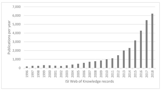
Figure 1.
Records in ISI Web of Knowledge using search criteria: TS = (remotely piloted aircraft system* OR rpas OR unmanned aerial system* OR uas OR unmanned aerial vehicle* OR uav OR drone*). Source: search performed by the authors on ISI Web of Knowledge.
We present our results as follows. First, we offer an overview of the experiences at the global level according to the six aforementioned categories. Then, we present an individual description of the experiences in chronological order for three regions: the Americas, Eurasia and Oceania, and Africa. At the end of each section, we provide a table to summarize the previously described results.
3. Results
We systematized 39 experiences between October 2012 and December 2017: Latin America and the Caribbean, Asia, Africa, Oceania, Europe, and North America (1) (Figure 2). Thirty-two experiences used commercial drones (6 used only fixed-wing, 21 only multirotor, and 5both), 12 used DIY drones (3 fixed-wing, 6 multirotor, and 3 both), and only one experience used both options and types. The most commonly used commercial drones were the eBee (fixed-wing) and Phantom (multirotor).
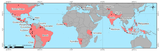
Figure 2.
Geographical location of the community drone experiences found. Gray countries reflect no experiences found in the review, while pink ones show countries where at least one experience was found. Dots show the locations of specific experiences.
Regarding the purposes of community drones, we found 18 cases of territorial defense, 18 of training, 9 of monitoring, 7 of formalization of land ownership, 4 of post-disaster humanitarian aid, and 2 of environmental activism; 10 experiences had even more specific purposes. The most usual form of community participation was participatory mapping, followed by participatory workshops, geographic information systems, volunteered geographic information, participatory geographical information systems, monitoring, counter-mapping (3) and activism (3). We allocated 21 experiences to one participation category, 12 to two, and 6 to three or more.
3.1. The Americas
In October 2012, Hurricane Sandy hit Haiti, prompting the deployment of International Organization for Migration (IOM) and the Haitian OpenStreetMap Community, using a fixed-wing drone to acquire aerial information of the more affected areas [34]. The information gathered made it possible to quantify the damaged infrastructure using GIS and update the OpenStreetMap cartography [34]. Drone Adventures used more advanced fixed-wing drones to fly over Haiti during April 2013 and, in 2015, acquired a multirotor to complement its activities [35]. Following its intervention, Drone Adventures donated a fixed-wing drone to OpenStreetMap Haiti to strengthen and make its work less dependent on IOM [34].
In 2013 in Suriname, GISsat flew over an indigenous community with a fixed-wing drone to monitor deforestation, survey housing areas and supply orthophotomaps to the government and local NGOs [36]. Local participation was limited to permitting the activity and establishing terrestrial control points to georeference the images [37]. This experience allowed the indigenous community to document the occurrence of illegal mining and forestry activities on their lands [38].
In 2013 in Chihuahua (Mexico), the National Laboratory for Sustainability Sciences (LANCIS) of the National Autonomous University of Mexico (UNAM) was appointed by indigenous communities as an expert in a federal lawsuit on the construction of Creel International Airport (officially Barrancas del Cobre Regional Airport) [39]. The changes in relief and the effects on roads and watercourses after the construction of the airport were assessed by LANCIS using a multirotor drone [40]. After LANCIS’ appraisal, the affected communities won constitutional protection [40] and received 65 million Mexican pesos ($4 million USD) as compensation [40].
Also in 2013, in Oaxaca (Mexico), the Sea University (Universidad del Mar) zoned a Voluntary Area for Conservation in Puerto Angel with a multirotor drone delimiting the uses and core area through participatory mapping with the property owners [41]. In Morro Ayuta, the Federal Prosecutor’s Office for Environmental Protection (PROFEPA) implemented monitoring with multirotor drones to prevent the looting of turtle nests [42]. It later trained communities to use them as an alternative counting method [43].
During May and June 2014 in Haiti, CartONG, OpenStreetMap France, and Fondation de France strengthened OpenStreetMap Haiti in data acquisition to generate VGI using fixed-wing drones [44,45]. The initiative stimulated the reuse of data to support development projects, risk prevention, and the leadership of OpenStreetMap Haiti in its own projects [44,45]. Multirotor drones were also used [46]. Data analysis focused on northern Port-au-Prince through participatory mapping and VGI channeled through OpenStreetMap [47]. In 2015 OpenStreetMap Haiti created the NGO Potentiel3.0 to better respond to hydrological risks through social and digital innovation, including drone images [34].
In August 2014 in Loreto (Peru), Tushevs Aerials used a fixed-wing drone assembled in a training workshop for indigenous communities in which they could detect a remote oil spill that had occurred a year earlier yet without remediation [48,49]. The Interethnic Association for the Development of the Peruvian Amazon (AIDESEP) coordinated the workshop with assistance from Rainforest Foundation US, UNAM’s Center of Research in Environmental Geography (CIGA) and Burgess Communications in charge of its audiovisual documentation [7]. The workshop demonstrated the efficacy of drones for mapping environmental impacts from oil activities across indigenous territories. The assembled drone was kept by AIDESEP for further training and future monitoring activities in the Peruvian Amazon [7].
In October 2014, in the savannahs of southern Rupununi (Guyana), the NGO Digital Democracy taught a team of Wapichana indigenous monitors to build, repair, fly and process images obtained with a fixed-wing drone to improve community forest monitoring and territorial defense against illegal logging and gold mining [7,50]. During one week they performed test flights with two drones, demonstrating the feasibility of assembling and using drones with indigenous communities without previous experience [7,50].
In August 2015 in Madre de Dios (Peru), UNAM’s CIGA conducted another training following a request by AIDESEP, the Coordination of Indigenous Organizations of the Amazon Basin (COICA) and the Native Federation of Madre de Dios (FENAMAD), with funding from the Dutch NGO Hivos [7]. The impacts of illegal gold mining in the area were documented with a multirotor drone [7,51]. In a four-day workshop, they proved that indigenous communities could use multirotor drones manually to document such impacts with no prior drone knowledge and little technical assistance [7]. AIDESEP partnered with Oxfam in 2018 to give continuity to this project, as well as training and equipment to other communities interested in using drones [52].
In August 2015 in the Embera-Wounaan Region (Panama), Tushevs Aerials documented illegal deforestation using fixed-wing and multirotor drones during a workshop organized by the National Coordination of Indigenous Peoples of Panama (COONAPIP) and funded by Rainforest Foundation US [53]. Participants were trained in the use of drones and the processing of georeferenced information to collect evidence of territorial effects caused by colonization processes [7,53].
In August 2015 in Rio de Janeiro (Brazil), the Brazilian Public University mapped with multirotor drones “real estate violence and enclosures of common goods” in the framework of the projects Flone, the flying phone and #DroneHackademy [31,32]. Funding came from the academic project #DroneHackademy, whose participants were selected in a public call from the University [32]. They flew over the site under construction for the Rio de Janeiro 2016 Olympic Games and made a mosaic with Mapknitter from Public Lab, which they handed out in print in a public ceremony to the residents of the area affected by the construction [32].
In the area of training on the use of drones in Latin America, the project #DroneHackademy—which addresses their activist use, claiming the “right to look”—is worth highlighting [32]. Droncita offers an example of the activist use of multirotor drones in Mexico, as it has been used to denounce the impacts of the construction of a highway in San Francisco Xochicuautla (State of Mexico) [31] and to document citizen mobilizations.
In September 2015 in Nemopare and Kiwaro (Ecuador), Digital Democracy trained Waorani indigenous people in the use of multirotor drones to document the negative impacts generated by oil infrastructure, roads, and oil palm plantations in their territories [54]. The activities were co-financed by the ClearWater project and Digital Democracy [54].
During 2015 in Ayacucho and La Libertad (Peru), the NGO Land Alliance tested a method of participatory rural cadastral survey using a fixed-wing drone. The potential of drones in cadastral surveys was demonstrated, as well as the legitimacy of the cartography generated by the beneficiaries, which made it possible to resolve conflicts over land ownership [55,56]. The method proved to be more efficient than those traditionally used (total stations, tape, and compass) [55,56].
Between 2015 and 2016 in the communities of Surama and Wowetta (Guyana), the University of Dallas trained Macushi farmers in the assembly and operation of DIY multirotor drones to investigate land use changes in agricultural parcels, tropical forests, and mangroves; this experience was carried out as part of the efforts to include indigenous communities in the national program to reduce emissions from deforestation and forest degradation (REDD+) [57,58]. Two people from each community were selected and received training in the assembly, overflight planning, use of GPS devices, and collection of ground control points [59].
In August 2016 in the Chiman district (Panama), COONAPIP, with support from Rainforest Foundation US and the United Nations Food and Agriculture Organization (FAO), held a month-long training workshop on drone use [53]. After the workshop, two fixed-wing drones were donated to COONAPIP, valued at $15,000 USD, in addition to a multirotor previously donated by Rainforest Foundation US [53,60].
During 2016 in North Dakota (United States), several activists documented with multirotor drones the impact of the Dakota Access Pipeline project on Sioux indigenous territories [8]. On several occasions, the police shot down drones [61,62], which led the Federal Aviation Administration to issue temporary flight restrictions covering the settlement areas of the demonstrators and where the pipeline was planned to be built, making its use in protests temporarily illegal [61,63]. These temporary flight restrictions were debated in the media and were of concern to activists interested in documenting the protests with drones [64]. In the country, there were records of drones belonging to environmental activists shot down by hunters [65], but not by police.
In 2016, the coastal Comcaac indigenous communities in Sonora (Mexico) hired ValkiriasUAV to be trained in the assembly and operation of fixed-wing drones. They were economically supported by the National Commission of Protected Natural Areas (CONANP) and influenced by the Conservation Drones project [66]. Terrain complexity prevented the use of fixed-wing drones and DIY Robotics was hired for training in design, assembly, and operation of multirotor drones [66]. Technical, maintenance, and software limitations were perceived during training, which led to the acquisition of commercial multirotors and further training with ValkiriasUAV [66]. Drones enhance territorial defense and complement data acquired by trap cameras, biological monitoring, community surveillance, ecosystem sanitation work, and audiovisual broadcasting [66]. The cartography with drones required collaborations to process and analyze the information, using ValkiriasUAV as technical support and SIGALT for the processing and analysis of information [66].
In 2016, more than 20 youth from Guatemala and Honduras were trained in the assembly and use of fixed-wing and multirotor drones [67]. The workshop took place in the department of Totonicapán and in the Petén’s forest concessions [67]. The participants belonged to the Asociación de Comunidades Forestales de Petén and was sponsored by the European Union, who donated multirotor drones [68]. The workshop focused on monitoring forests and wildfires [68].
Between 2016 and 2017 in Michoacán (Mexico), the potential use of commercial multirotor drones for environmental monitoring processes and indigenous territorial defense was evaluated within the framework of an MSc thesis at UNAM’s CIGA [20]. Through workshops, two indigenous communities in Michoacán were trained in the use of drones and participatory mapping [20]. The construction of a hydroelectric dam in Puebla and a new road development in Morelia were also flown over with commercial multirotor drones to strengthen territorial defense [6,20]. This study demonstrated the potential of multirotor commercial drones for territorial defense of communities in Mexico despite increasing legal limitations and widespread violence [20].
In March 2017, Mocoa (Colombia) was affected by a torrential avenue. Pre-disaster mapping was done in two days through OpenStreetMap [69]. The affected areas were flown over by multirotor drones from the Humanitarian Mapping Unit and GlobalMedic’s RescUAV team [70,71]. The orthomosaics made it possible to update the post-disaster mapping in OpenStreetMap and provide recent information to government agencies in charge of humanitarian aid [70]. OpenStreetMap Foundation Colombia conducted two participatory mapping workshops, and explained to the population the usefulness of mobile applications for resettlement and post-disaster reconstruction [72]. Afterward, the Humanitarian Mapping Unit flew over a previously uncovered area, completing post-disaster mapping and providing additional information for humanitarian work.
Since 2017 in the Sierra del Divisor National Park (Peru), Rainforest Foundation US has partnered with Shipibo-Konibo indigenous communities to defend their territories from illegal loggers, miners and coca growers [73,74]. Rainforest Foundation has trained communities “to map their lands and taught them to interpret satellite data to identify incursions in near-real time” [74]. Indigenous communities were also trained in multirotor drone operation to identify and prove illegal incursions and activities in their lands [73,74]. This monitoring program using drones and satellite imagery is being expanded by Rainforest Foundation US to some 40 communities in Peru, where drones are given to each community [73,75]. However, these indigenous communities complain about the Peruvian government’s slow response regarding illegal encroachment on their territories [75].
Between March 2017 and November 2018 in Zitácuaro (Mexico), the potential use of DIY multirotor drones for environmental monitoring was evaluated with Carpinteros Indigenous Community within the framework of an MSc thesis at CIGA [76]. Participatory DIY drone assembly workshops as well as flight practices with commercial multirotor drones took place with a group of children and adolescents from the community [76]. Participatory mapping workshops, photogrammetry training, and cartographic analysis with GIS were also conducted [76]. Despite limited access to internet and geospatial technologies, this project revealed the potential of drones for environmental monitoring and territorial defense [76].
In October 2017 in Valparaíso (Chile), the Centre of Research in Territorial Informality and Vulnerability (CINVIT) launched the project Dronmap Participativo to “generate binding processes of planning, construction and/or management of the urban environment between a specific community and a public and/or private body” [77]. CINVIT overflowed informal settlements prone to risks (e.g., landslides, fires), and generated detailed maps of the settlements using a multirotor drone, followed by participatory mapping workshops with their inhabitants [77]. Two- and three-dimensional maps of participatory risk perception were made, the entire process was systematized by CINVIT, and reports were delivered to the community and to the public and/or private organizations involved [77]. Between 2017 and 2018 Dronmap was implemented in four informal settlements in Valparaiso. In November 2017 Dronmap was also implemented in Medellin (Colombia), in La Cruz district and La Honda sector [77,78].
During 2017 in San Cristobal (Peru), the International Institute of Social Studies (ISS) at Holland’s Erasmus University and Digital Democracy trained indigenous monitors from Amazonian Indigenous Peoples United in Defense of their Territories (PUINAMUDT) to use multirotor drones to document oil spills [79,80]. Digital Democracy trained monitors in the use of smartphones and drones to gather georeferenced evidence of unreported or unattended spills and leaks caused by oil companies [79]. This training is part of a coalition called All Eyes on the Amazon, funded by the Dutch National Postcode Lottery’s Dream Fund and led by Hivos, Greenpeace, COICA, ISS, Digital Democracy, the World Resources Institute, the University of Maryland, INTERPOL’s Law Enforcement Assistance for Forests project, and the NGOs Both Ends, Witness and Article 19 [81].
In 2017, the Kofan indigenous community of Sinangoe (Ecuador) approached the indigenous organization Ceibo Alliance, an Amazon Frontlines partner, asking for help to defend their territory against illegal gold mining, fishing, and hunting [82]. The community had been using GPS devices, smartphones, hidden cameras, and multirotor drones to gather evidence of the illegal activities [83,84,85]. The drones were piloted by Amazon Frontlines staff [86]. All these surveillance tools have been key to demonstrate the effectiveness of indigenous-led environmental monitoring, and have contributed to legal territorial recognition by the Ecuadorian government [87].
Table 2 presents a synthesis of the experiences found for the Americas.
Table 2.
Synthesis of the use of community drones in the Americas. Acronyms as in Table 1.
3.2. Eurasia and Oceania
In 2013 in Kalimantan (Indonesia), the Swandiri Institute and local NGOs documented land grabs by oil palm companies and bauxite mining to protect the territorial rights of affected indigenous communities; to do so, they used fixed-wing and multirotor drones [5,89]. The lack of territorial recognition of indigenous peoples by the State motivated the use of drones too, which demonstrated their occupation in areas previously classified as forests [5,90,91]. The Swandiri Institute established a school of drones in Pontianak to train communities and activists how to use them for counter-mapping [5]. By 2015 they could map 1000 hectares in one working day [89], while by 2016, they were exploring simultaneous overflights with fixed-wing equipment [92].
During 2013 in Albania (Eastern Europe), a pilot project funded by the World Bank assessed the potential of multirotor drones for cadastral regularization and updating, urban planning, and asset management [36]. In this project, Micro Aerial Projects carried out three case studies in Fushë Milot (an agricultural area, an urban area and on a motorway) [12,36]. The project reported great potential for the use of information generated with drones in participatory mapping activities linked to land ownership [9,10,12,36].
In April 2015, an earthquake occurred near Kathmandu (Nepal). Following the disaster (September 2015), UAViators, Kathmandu University, Kathmandu Living Labs, Nepal’s Civil Aviation Authority (CAA), DJI and Pix4D conducted a three-day training workshop in Kathmandu on the use of multirotor drones and data processing, training more than 30 people [93]. The village of Panga, severely affected by the earthquake, was flown over for two days with six drones and the affected buildings were identified and inventoried in a participatory mapping workshop using the printed orthomosaics obtained with drones [93]. After the workshop, 10 multirotor drones were donated to Kathmandu University and Kathmandu Living Labs for continued mapping [94]. The experiences of Kathmandu and Panga led to the co-creation of a FlyingLabs in Nepal, an initiative of WeRobotics.
In October 2015, the Lunyuk Ode village (Indonesia) was flown over with a multirotor drone within the framework of an MSc thesis at the Faculty of Geo-Information Science and Earth Observation from the University of Twente [95,96]. The aim of this research was to determine the feasibility of drones for cadastral boundary surveys in terms of time, cost, and spatial accuracy [95,96]. The research demonstrated the feasibility of drones for participatory boundary mapping in farmlands [95,96].
During June 2016 in Cordova, Cebu Province (Philippines), the Asia Foundation in collaboration with the Foundation for Economic Freedom, Omidyar Network, and Micro Aerial Projects used a multirotor drone to formalize land ownership rights [13]. The detail of the orthomosaics enabled work on the information printed by the community, thus facilitating the identification of plots and the resolution of local disputes related to their property [13,14].
In July 2016, in the Tajik Pamir Mountains (Tajikistan), Focus Humanitarian Assistance flew fixed-wing drones over two watersheds susceptible to avalanches and landslides that could affect the villages of Barsem and Darjomj [97]. The activities were part of the Drones in Humanitarian Action initiative [98] funded by the European Civil Protection and Humanitarian Aid Operation [97], Swiss Foundation for Mine Action and CartONG [99]. Fifty flights, three drones, two pilots, two laptops, four cameras (two RGB and two NIR), 25 batteries and 10 days were required to provide information that would allow Focus Humanitarian Assistance and the national government to create watershed risk maps (~20 km2) for educational purposes, and the German Agency for International Cooperation to analyze erosion patterns in mountains and riverbeds, study land cover and train locals in disaster risk reduction [97,99].
In 2016, the NGO Outline India used a multirotor drone to map the Bhora Khurd village in Haryana (India) [100]. The flights sought to spatially understand the demographic and socioeconomic profiles of the village, study basic infrastructure services, and identify priority intervention areas [100,101]. Participatory methods like transect walks, interviews, and detailed observation and mapping of the village took place [102]. This pilot study showed that detailed geographic information gathered with drones could lead to better understanding of local communities’ issues [100].
Between December 2016 and March 2017, Bengkulu Tengah (West Sumatra), Bogor (West Java), and Kembangan (West Jakarta) districts (Indonesia) were flown over with a multirotor drone within the framework of an MSc thesis at the Laboratory of Geo-Information Science and Remote Sensing from the Wageningen University [103]. The aim of the research was to investigate whether the use of drones could replace terrestrial methods for land registration [103]. Participatory mapping workshops and field trips were conducted with local communities to prove the feasibility of drones for participatory cadastral purposes [103]. This research concluded that participatory boundary mapping using drones is not entirely efficient given the logistical difficulties to gather local communities in one place and to establish direct communication with land owners [103].
In 2017, in the Maabaidhoo Island (Maldives), the United Nations Development Programme (UNDP) and DJI partnered to provide drones to local emergency response groups [104]. The partnership sought to “empower vulnerable communities to better prepare to [sic] challenges posed by climate change” [105]. The information captured was used by disaster management teams, emergency personnel, and scientists to identify eroded coastlines, update risk maps, and “restore coral reef systems, plant mangroves, reinforce seawalls and more” [105]. Local emergency officials and Maldives National Defence Force were trained in the use of drones with cartographic purposes [106,107]. Twenty islands were equipped with multirotor drones [107].
In December 2017 in Kutupalong Refugee Camp (Bangladesh), Caritas Bangladesh and the Catholic Relief Services conducted a participatory mapping workshop with Rohingya refugees from Myanmar [108]. The mapping workshop aimed to identify hazard exposure levels to floods and cyclones [108]. The participatory mapping process created a sense of ownership and belonging [108]. The workshop employed publicly shared fixed-wing drone imagery captured by IOM [108]. Table 3 offers a synthesis of the experiences found in Eurasia and Oceania.
Table 3.
Synthesis of the use of community drones in Eurasia and Oceania. Acronyms as in Table 1.
3.3. Africa
In June 2014, in the Prefecture of Forecariah (Guinea), the United States Geological Survey (USGS), the United States Department of State, and the United States Agency for International Development (USAID) supported with drones the international Diamond Development Initiative, aimed at preventing the sale of diamonds to finance armed conflicts and civil wars [110]. The flights sought to prove the viability of drones for monitoring small-scale artisanal diamond mining, and to support formalization and governance processes over the resource within the framework of USAID’s Property Rights and Artisanal Diamond Development project [110]. Mining and agricultural zones were demarcated with Forecariah communities using participatory mapping [110].
In January 2015, the Freedom Square informal settlement located in Gobabis (Namibia) was flown over with a fixed-wing drone within the framework of an MSc thesis at the Faculty of Geo-Information Science and Earth Observation from the University of Twente [111]. The aim of the research was to evaluate the drone as a surveying method for mapping customary land rights [111]. Local participation involved establishing terrestrial control points for georeference purposes [111] and the digital demarcation of parcels by owners using a laptop and GIS software [112]. This research demonstrated the feasibility of drone imagery to promote citizen participation and the importance of engaging owners in the demarcation process to prevent or minimize boundary disputes [112].
Between April and May 2015 in Dar es Salaam (Tanzania), the World Bank through the Global Facility for Disaster Risk Reduction program, Drone Adventures, Tanzania Commission for Science and Technology, the Swedish International Development Cooperation Agency, and the Tanzanian Red Cross flew over ~90 km2 of the city with fixed-wing and multirotor drones [113,114]. The latter were also used to capture audiovisual material. The project objective was to create a digital terrain elevation model to generate reliable flood models [113,114] and provide current, accurate, and detailed information for urban growth planning in Dar es Salaam [115]. Following the flights, the Dar Ramani Huria participatory mapping exercise (which in Swahili means “to give open maps”) was carried out. This included training in cartography, field data collection with GPS and smartphones, and mapping in OpenStreetMap [116].
During 2016, the Ulanga, Kilombero, and Malinyi districts of Morogoro (Tanzania) were flown over with fixed-wing drones by the Tanzania Commission for Science and Technology and the Land Tenure Support Programme of the Ministry of Lands, Housing and Human Settlements Development, supported by the World Bank and the international cooperation agencies of Denmark, the United Kingdom, and Sweden, as well as Uhurulabs [15,16]. The flights aimed to recognize >300,000 property titles, resolve property conflicts through participatory mapping, and facilitate access to agricultural credit [15,16].
Table 4 summarizes the systematized experiences in Africa.
Table 4.
Synthesis of the use of community drones in Africa. Acronyms as in Table 1.
4. Discussion
Four main findings stem from our review: (1) most community drone experiences occurred from 2014 onward and were located in developing countries, particularly in Latin America; (2) in Indonesia and Latin America, most experiences were associated with training for territorial mapping and defense, whilst elsewhere, they were mainly geared toward environmental monitoring, land ownership formalization, and activism; (3) community participation was relatively low and constrained by top-down approaches; (4) guidelines for appropriate practices in community drones were absent. We first provide a reflection about some potential biases of our review and then discuss each finding in the same order as above.
4.1. Potential Biases
The prominence of experiences found across Latin America flags a potential geographical bias. Some of the issues that may have influenced our results are the algorithms used by Google and Google Scholar to search, the languages used to search for literature and information (mainly English and Spanish, and to a much lesser extent, French and Portuguese), and our greater familiarity with the use of community drones in the region. Thereby, it is likely that we have missed community drone experiences in other regions that are unfamiliar to us where they may have been reported on in other languages (e.g., Mandarin Chinese, Hindustani, Arabic, Malay, Russian). Similar reviews by researchers who are native to other widely spoken languages from other continents would be needed to complement this review. This geographical bias also reflects the scarcity of academic literature on the subject.
We observed that many experiences were published or reported on long after fieldwork completion (even several years). This may have resulted in some experiences missed within the study period. We also observed that the dissemination of information about community drone projects tends to be greater when NGOs or international cooperation agencies are involved, possibly because of the commitments made beforehand to report on results. This may partially explain the scarcity of bottom-up experiences found. Community interests and constraints do seldom give importance or allow time to disseminate their activities, unlike academics or organizations that promote community drones.
The need for using gray literature as the main source of information, the diversity of ways in which it presents information, and its frequent lack of comprehensiveness made it difficult to analyze and compare the results from the found experiences. We identified publication bias, and key issues like the purposes that motivate the use of community drones were sometimes unclear or poorly reported. Similarly, the area flown over in each experience was often unstated; nevertheless, since information on types and brands of drones used was generally available, at least for commercial drones user manuals and manufacturers’ websites can be used to obtain approximate data (contrarily, estimating the area covered by DIY drones is more difficult).
4.2. Spatial and Temporal Distribution of Community Drones
The geographical distribution of the found experiences reveals that the emergence of community drones has been mainly motivated by two factors: (1) the need to document and report territorial impacts for improved community defense; (2) the absence of detailed, accurate, and up-to-date maps for informed decision-making. Both factors typically coexist in developing countries [117] and have motivated the direct and indirect intervention of international cooperation agencies, the United Nations through its different bodies, and/or NGOs in most of the experiences reviewed.
We observe a proliferation of community drones from 2014 onward, mainly in Latin America. Many experiences aimed at improving territorial defense. This process may have been facilitated in Latin America by at least two factors: (1) many indigenous groups have gained formal recognition of their customary lands from the state in the last decades [118] but their territories face many threats [119,120,121]; (2) the absence or ambiguity of new national regulatory frameworks to operate and import drones in the region [18,122]. However, Latin American regulatory frameworks are being readjusted in a trend that may discourage or even ban community drones. In fact, most regulatory frameworks for drones do not even consider communities as legitimate, potential drone users. Thereby, the use of drones with/by communities might decrease in some countries in the near future [6,20,122].
In other regions like Africa, Asia, and the Global North—unlike in Latin America—there is little land inhabited by indigenous peoples and local communities that has been recognized by the state [123,124]. If local peoples do not possess the land they inhabit, then flying drones for territorial defense or land management probably makes no sense. Regarding the absence of regulatory frameworks, on the other hand, the situation has in these areas been probably similar to that in Latin America. Other reasons that might explain the few experiences found outside of Latin America can be linked to higher levels of state control and repression (e.g., China, many countries in the Middle East and Africa), as well as fewer national and international NGOs willing to support local communities in their struggles against multinationals or the state itself. The predominance of experiences in developing countries also leads us to ask: why are there so few experiences in developed countries such as the United States, Canada, or Australia, where there are many indigenous groups and English is the official language? The recent Sioux experience and the government’s response regarding their use of drones [61,62,63,64,65] leads us to think that these peoples might be as oppressed as those living in developing countries [125].
4.3. Main Objectives of Community Drones
The predominance of certain objectives in each region reflects the role and interests of local and external actors. Those focused on territorial defense (Latin America, Indonesia, and the United States) involve political ends and confrontations with companies and governments, and the support of national and international NGOs is common. Experiences focused on land ownership formalization, humanitarian aid, urban planning, and risk management (Africa and Eurasia), on the other hand, involve the use of more sophisticated, expensive drones; this is why international cooperation agencies, multilateral organizations, and government agencies tend to be present, either financing activities or facilitating logistical aspects. We found few experiences of territorial defense with indigenous communities (e.g., COONAPIP in Panama, Comcaac peoples in Mexico) in which governmental agencies participated. These few cases could be explained by the coincidence between community and government objectives associated with biological conservation.
We consider that Latin America and Indonesia stand out in the use of drones for territorial defense given the geopolitical nature of their economies [126,127,128], the rise of extractivism, and the emergence of environmental justice movements from indigenous peoples and their allies [129,130]. Although some of these characteristics are also present in Africa and other countries in Asia, we attribute the absence of territorial defense experiences in both areas to the scarcity of land officially titled to indigenous and local communities as the states tend to retain the property of lands historically inhabited by such communities [123]; this situation contrasts with the significant amount of land that has been returned to indigenous peoples in Latin America over the last decades as mentioned [118,131].
4.4. Participation in Community Drones
The importance of participation in issues of people’s concern is very well established in the literature of community-based natural resource management/monitoring and citizen science [132,133] as well as that of their traditional knowledge, which can add up to that produced by western science [134,135]. Failing to do so has been proven to severely constraint the scope of the achievements that can be attained by fostering greater local involvement and taking advantage of their knowledge, skills, and ingenuity [135,136,137].
Despite strong community interest in using drones in the experiences reviewed, local participation was limited by top-down approaches which tended to neglect local territorial knowledge. Thus, the co-production of knowledge was generally subordinated to the technical nature of the knowledge and skills necessary to fly drones, and to process and analyze the imagery acquired with them. However, several experiences have already shown that communities can learn to operate drones, and even to process and analyze imagery to produce accurate maps of their territories without prior knowledge of this technology [5,7,20,76]. Our own recent experience in Mexico training community members to assemble and fly DIY drones, as well as performing basic GIS tasks to make maps from the imagery acquired by themselves with drones, support such a claim. Communities’ designated individuals must become autonomous drone and GIS users if community drones are to fully meet their needs and expectations in the near future [6,76]. As shown in the results section, some communities have already begun down that pathway.
Another reason that has limited local participation relates to big data issues [138]. Some experiences recognize, in big data, challenges and opportunities to establish alliances with other actors [66] (e.g., scientists) or to resort to participatory methodologies (e.g., PM, VGI, PGIS) to analyze the information [10,13,17,20,45,72]. Territorial defense and humanitarian aid experiences also agree on the importance of training local actors to pilot drones and process and analyze the gathered information, recognizing that this requires high-end hardware and specific commercial, expensive software [5,66,76,93]. Thus, a technical constraint usually persists linked to the acquisition and appropriation of technology as well as the processing and use of the imagery and resulting products. Sometimes, a lack of access to the internet, electricity, and/or computer technologies is considered a key factor for failure because it poses technical constraints to drone use, effective community participation, and local use and analysis of gathered data [5,7,20,76]. Either way, community use of drones appears to be most successful when the purpose of their use directly addresses local needs and interests.
The scarcity of bottom-up experiences limits our understanding of why communities have a growing interest in using drones. We believe that their main motivation lies in getting detailed, accurate, and up-to-date spatial information of their territories to demonstrate territorial impacts, address land conflicts, or prepare for natural hazards, even though access to drones and training have so far relied almost entirely on external financing and assistance.
Although we recognize the importance of training communities that want to use drones, we warn against the absence of discussions on social, ethical, and political aspects regarding community drones—these should play a key role before, during, and after training implementation to ensure an adequate level of community participation, engagement, and reflection. Some ethical, security, and privacy issues have already been discussed [139,140,141,142,143,144,145,146]. However, we consider that in indigenous and local communities such concerns should be addressed considering their specific territorial rights. Thus, we posit that specific drone regulations should be issued for their territories so that such communities own the airspace besides the land.
4.5. Appropriate Practices in Community Drones
The economic and technical requirements of community drones tend to be well documented. On the contrary, little or no attention is paid to appropriate (and inappropriate) practices despite the social risks of this new technology. Some experiences highlight the importance of conducting community diagnoses prior to the introduction of drones, both to optimize time and resources [5,20,66] and to avoid aggravating tensions or conflicts when the information serves political ends [6]. In humanitarian aid and risk management initiatives, their purpose often justifies the free and open character of the generated data; in such emergencies, the acquisition of free, prior, and informed consent (FPIC) may sometimes be relaxed. In most cases, however, we suggest the need for working with communities on a drone plan before their deployment, to establish important issues such as the intended use of drones, trainings, project management, and data ownership [20].
Due to the diversity of purposes and possible ethical problems arising from the misuse of drones and/or the information they collect, we argue that appropriate practices need to be established together with communities. Considering the growing use of community drones and the scarcity of information on such practices, we offer guidelines here for appropriate practices based on the findings on this review and our own experience working on community drones (Appendix A).
5. Conclusions
With this review, we contribute to the novel academic topic of “community drones”. We have systematized the existing scarce and disperse information on community drones in two languages, which has been mostly published as gray rather than academic literature. Our review unveils increasing global interest and recent regional trends in the emergence of community drones. In the last decade, cheaper and easy-to-use drone technology has favored the growing interest of communities, mainly motivated by territorial threats that require up-to-date, accurate, and detailed information for decision-making. Simultaneously, regulations that limit the deployment of community drones to local, close-range areas have been developed in many countries to allegedly guarantee their safe operation. Both trends pose opportunities and challenges for community drones use.
On the one hand, we have highlighted the potential benefits of community drones, particularly when their use responds to local interests and needs and allows for effective community participation. On the other, we have evidenced the externally driven, top-down, mostly technical and utilitarian approaches that have so far characterized community drones, which have subordinated political and social approaches, thus limiting community participation and traditional knowledge. Therefore, much importance has been given to obtaining end products (e.g., imagery, maps, videos) at the expense of neglecting the process and, hence, community involvement for their own interests and needs. Further, based on this review’s findings and our own research and activist experience working on community drones, we have developed guidelines for appropriate practices.
This review may help push forward the use of drones with/by communities interested in this technology, as well as informing issues that are relevant for policymaking and regulations. The inclusion of community drones in public policies and regulatory frameworks is paramount, for instance, regarding the recognition of indigenous communities’ territorial rights. This may require country-/state-specific regulatory framework analyses aimed at reconciling International Civil Aviation Organization guidelines with domestic regulations and communities’ needs and realities, or even to acknowledge community rights to regulate the use of the airspace over their territories. Otherwise, current trends in drone regulations will continue to limit, or even prohibit, community drones.
We emphasize that research on community drones would benefit from systematic, accurate documentation gathered and shared by the actors responsible for the experiences. Without that documentation, it will be more difficult to further develop appropriate practices and to identify technologies and methodologies more suitable to community drones. The informational categories used in this review could be useful to guide such documentation by communities and their partners.
Further research is needed to devise, together with communities, new methods that align with participatory action research and popular education approaches; that way, community participation would be enhanced and culturally appropriate. The understanding of the global emergence of community drones would benefit from other reviews carried out by researchers in regions where we have identified geographical and language biases. Such reviews would also help define, more accurately, the period over which the global emergence of community drones has taken place and its geographical scope. Finally, we foresee novel theoretical avenues for research on community drones from the fields of political ecology, community-based natural resource management/monitoring, citizen science (particularly as approached by the social sciences), and grassroots innovation.
Author Contributions
N.V.-R. designed the study, conducted the review and wrote a preliminary version of the paper. J.P.-G. helped improve the design and scope of the review and edited the initial manuscript toward a final version.
Acknowledgments
Nicolás Vargas-Ramírez acknowledges the support of UNAM’s Postgraduate Program in Geography as well as the fellowship for his postgraduate studies (CVU/grant holder number: 710901/ 420676) received from the National Council of Science and Technology of Mexico (CONACYT). Jaime Paneque-Gálvez acknowledges financial support from DGAPA/UNAM PAPIIT IA301817, PAPIIT IA301919, and PAPIME PE309317 projects. We thank Gerardo Bocco and Claudio Garibay for providing comments on a first version of the manuscript. We thank Brian Napoletano for proofreading the revised version of the manuscript. The feedback and critical comments provided by two anonymous reviewers helped us improve the manuscript.
Conflicts of Interest
The authors declare no conflict of interest.
Appendix A. Suggested Guidelines for Appropriate Practices in Community Drones
Preliminary diagnosis: Aimed at identifying (i) ongoing activities or projects that can be benefited (or hindered) by the use of drones; (ii) actors within and outside the community that can support (or oppose) the use of drones or the information collected; (iii) power structures and local governments that can be affected (positively or negatively) by the use of drones or the (centralized or decentralized) management of information; (iv) conflict situations that can escalate or ameliorate by the use of drones; (v) local capacities (e.g., numeracy, computer literacy) and available infrastructure (e.g., electricity, internet, mobile phone coverage, computer equipment, smartphones); and (iv) local rules (formal and informal) and local and national legislation that favor or limit the use of drones.
Design: To determine the (i) purpose and need of images or videos for cartographic or audiovisual purposes; (ii) extent that needs to be covered and biophysical characteristics of the terrain to choose the type of drone to be used; (iii) need for theoretically, practically and/or technically training the community for the use, processing and analysis of the information; (iv) need for external technical and/or economic support, and for how long it can be secured; (v) need to establish agreements or standards (formal or informal) for the use and management of drones and captured information; and (vi) most appropriate methodologies for community participation in information analysis.
Implementation: Depending on the purpose and type of the community involved, determine (i) whether explicit free, prior, informed consent is required; (ii) the most appropriate means to deliver or disseminate the information locally (e.g., digital and/or printed, processed and/or unprocessed, in an assembly or only to leaders/representatives); (iii) whether terrestrial checkpoints are required to ensure adequate georeferencing of the information; (iv) the need for financial and/or technical support to implement participatory methodologies to analyze information; (v) public vs. private ways to access data and their copyright; (vi) the estimated lifespan of drones and computer equipment, and whether they can be easily replaced or repaired locally or regionally.
Monitoring: Depending on the type of drones and purposes, determine (i) whether the presence and use of drones has met community expectations; (ii) whether the type(s) of acquired drone(s) have responded to information requirements or require adjustments or replacement; (iii) whether other equipment (e.g., multispectral sensors), methodologies (e.g., physical and chemical analyses of water and soil), or actors (e.g., scientists or technicians) are necessary to validate or analyze drone data to meet community interests; (iv) whether the community has sufficient theoretical, practical, and technical knowledge to continue to use the drones by itself; (v) whether information requirements persist, or have changed or disappeared; (vi) if deployment of drones distracts attention from their intended use, address the situation with the community to establish appropriate corrective measures.
Ending: When the purpose behind the implementation is very specific and externally driven (e.g., in humanitarian aid situations), socialize and deliver the results to the community in an appropriate manner. If acquired drone imagery requires processing conditions not locally available and it is not possible to return (e.g., death threats, lack of funding), project leaders should establish, at the onset, a way to deliver results once they are available; otherwise, they must provide timely and transparent information about the impossibility of doing so. In this way, unmet expectations and mistrust regarding the destination and use of the information will not be generated.
References
- Kakaes, K.; Greenwood, F.; Lippincot, M.; Dosemagen, S.; Meier, P.; Wich, S. Drones and Aerial Observation New Technologies for Property Rights, Human Rights, and Global Development. A Primer; New America: Washington, DC, USA, 2015. [Google Scholar]
- Arfaoui, A. Unmanned aerial vehicle: Review of onboard sensors, application fields, open problems and research issues. Int. J. Image Process. 2017, 11, 12–24. [Google Scholar]
- Cummings, A.; McKee, A.; Kulkarni, K.; Markandey, N. The Rise of UAVs. Photogramm. Eng. Remote Sens. 2017, 83, 317–325. [Google Scholar] [CrossRef]
- Paneque-Gálvez, J.; McCall, M.K.; Napoletano, B.M.; Wich, S.A.; Koh, L.P. Small drones for community-based forest monitoring: An assessment of their feasibility and potential in tropical areas. Forests 2014, 5, 1481–1507. [Google Scholar] [CrossRef]
- Radjawali, I.; Pye, O. Drones for justice: Inclusive technology and river-related action research along the Kapuas. Geogr. Helv. 2017, 7, 17–27. [Google Scholar] [CrossRef]
- Paneque-Gálvez, J.; Vargas-Ramírez, N.; Morales-Magaña, M. Uso comunitario de pequeños vehículos aéreos no tripulados (drones) en conflictos ambientales: ¿Un factor innovador desequilibrante? Teknokultura 2016, 13, 655–679. [Google Scholar] [CrossRef]
- Paneque-Gálvez, J.; Vargas-Ramírez, N.; Napoletano, B.; Cummings, A. Grassroots innovation using drones for indigenous mapping and monitoring. Land 2017, 6, 86. [Google Scholar] [CrossRef]
- Mattozzi, S. Activists continue to fight against DAPL. The Newswire, 9 November 2016. [Google Scholar]
- Kelm, K.; Tonchovska, R.; Volkmann, W. Drones for Peace: Part II. Fast and Inexpensive Spatial Data Capture for Multi-Purpose Use. In Proceedings of the Annual World Bank Conference on Land and Poverty, Washington, DC, USA, 24–27 March 2014; p. 26. [Google Scholar]
- Barnes, G.; Volkmann, W.; Sherko, R.; Kelm, K. Drones for Peace: Part 1 of 2 Design and Testing of a UAV-Based Cadastral Surveying and Mapping Methodology in Albania. In Proceedings of the Annual World Bank Conference on Land and Poverty, Washington, DC, USA, 24–27 March 2014; p. 28. [Google Scholar]
- Barnes, G.; Volkmann, W. High-Resolution mapping with unmanned aerial systems. Surv. L. Inf. Sci. 2015, 74, 5–13. [Google Scholar]
- Kelm, K.; Tonchovska, R.; Volkmann, W. Albania Uses UAS for Development Projects. Available online: https://www.geospatialworld.net/article/albania-uses-uas-for-development-projects/ (accessed on 17 September 2018).
- Pablo, M.C.; Petzold, O. Using Drone Technology to Improve Land Titling in the Philippines. Available online: http://asiafoundation.org/2016/06/29/using-drone-technology-improve-land-titling-philippines/ (accessed on 17 September 2018).
- Foundation for Economic Freedom. Technology for Property Rights. Available online: https://youtu.be/W1JF5vzDfRc (accessed on 17 September 2018).
- Makoye, K. Tanzania Turns to Drones to Bring Peace in Bitter Fight for Land. Available online: http://www.reuters.com/article/tanzania-landrights-idUSL8N1BD36T (accessed on 17 September 2018).
- Tanzania Open Data Initiative. Drones and Land Tenure in Tanzania. Available online: https://youtu.be/tgrK-k9YXMc (accessed on 17 September 2018).
- Tanzania Open Data Initiative. Ramani Huria—Community Mapping in Dar es Salaam. Available online: https://youtu.be/7Pa0wgMstE8 (accessed on 11 September 2018).
- Stöcker, C.; Bennett, R.; Nex, F.; Gerke, M.; Zevenbergen, J. Review of the current state of UAV regulations. Remote Sens. 2017, 9, 459. [Google Scholar] [CrossRef]
- Haddaway, N.R.; Collins, A.M.; Coughlin, D.; Kirk, S. The role of Google Scholar in evidence reviews and its applicability to grey literature searching. PLoS ONE 2015, 10, e0138237. [Google Scholar] [CrossRef]
- Vargas-Ramírez, N. Evaluación del Potencial de Uso de Pequeños Vehículos Aéreos no Tripulados para el Monitoreo Ambiental y la Defensa Territorial Indígena en México. Master’s Thesis, Universidad Nacional Autónoma de México, Morelia, Michoacán, Mexico, 2018. [Google Scholar] [CrossRef]
- Danielsen, F.; Burgess, N.D.; Balmford, A.; Donald, P.F.; Funder, M.; Jones, J.P.G.; Alviola, P.; Balete, D.S.; Blomley, T.; Brashares, J.; et al. Local participation in natural resource monitoring: A characterization of approaches. Conserv. Biol. 2009, 23, 31–42. [Google Scholar] [CrossRef]
- Connor, D.M. A new ladder of citizen participation. Natl. Civ. Rev. 1988, 77, 249–257. [Google Scholar] [CrossRef]
- Goodchild, M.F. Citizens as sensors: The world of volunteered geography. GeoJournal 2007, 69, 211–221. [Google Scholar] [CrossRef]
- Goodchild, M.F. Geographic information systems and science: Today and tomorrow. Procedia Earth Planet Sci. 2009, 1, 1037–1043. [Google Scholar] [CrossRef]
- Dunn, C.E. Participatory GIS—A people’s GIS? Prog. Hum. Geogr. 2007, 31, 616–637. [Google Scholar] [CrossRef]
- Corbett, J.; Devos, S.; Di Gessa, S.; Fara, K.; Firmian, I.; Liversage, H.; Mangiafico, M.; Mauro, A.; Mwanundu, S.; Mutandi, R.; et al. Good Practices in Participatory Mapping; International Fund for Agricultural Development: Rome, Italy, 2009. [Google Scholar]
- Spellerberg, I.F. Monitoring Ecological Change, 2nd ed.; Cambridge University Press: Cambridge, UK, 2005. [Google Scholar]
- Peluso, N.L. Whose woods are these? Counter-Mapping forest territories in Kalimantan, Indonesia. Antipode 1995, 27, 383–406. [Google Scholar] [CrossRef]
- Giones, F.; Brem, A. From toys to tools: The co-evolution of technological and entrepreneurial developments in the drone industry. Bus. Horiz. 2017, 60, 875–884. [Google Scholar] [CrossRef]
- Magistretti, S.; Dell’Era, C. Unveiling opportunities afforded by emerging technologies: Evidences from the drone industry. Technol. Anal. Strateg. Manag. 2019, 31, 606–623. [Google Scholar] [CrossRef]
- Suárez, M. Colectivos sociales y ciborgs: Hacia una lectura feminista de los drones. Teknokultura 2016, 13, 271–288. [Google Scholar] [CrossRef]
- De Soto Suárez, P. Drone hackademy: Contravisualidad aérea y ciencia ciudadana para el uso de uavs como tecnología social. Teknokultura 2015, 12, 449–471. [Google Scholar] [CrossRef]
- Rotolo, D.; Hicks, D.; Martin, B.R. What is an emerging technology? Res. Policy 2015, 44, 1827–1843. [Google Scholar] [CrossRef]
- Lessard-Fontaine, A.; Alschner, F.; Soesilo, D. Case Study No. 6: Mapping—Rapid Damage Assessments of Tabarre and Surrounding Communities in Haiti Following Hurricane Sandy. Available online: http://drones.fsd.ch/wp-content/uploads/2016/04/Case-Study-Haiti.14April2016.pdf (accessed on 17 September 2018).
- Lessard-Fontaine, A.; Alschner, F.; Soesilo, D. Case Study No 7: Using High-Resolution Imagery to Support the Post-Earthquake Census in Port-au-Prince, Haiti. Available online: http://drones.fsd.ch/en/case-study-no-7-using-high-resolution-imagery-to-support-the-post-earthquake-census-in-port-au-prince-haiti/ (accessed on 6 June 2019).
- Greenwood, F. Mapping in Practice. In Drones and Aerial Observation: New Technologies for Property Rights, Human Rights, and Global Development. A Primer; New America: Washington, DC, USA, 2015; pp. 49–55. [Google Scholar]
- De Ridder, S.; Moerland, E. Social Mapping of Tribal Communities Using UAV Technology in Suriname. In Proceedings of the 2013 Esri International User Conference, San Diego, CA, USA, 8–12 July 2013. [Google Scholar]
- Moerland, E. UAVs Open Up a Whole New World. Available online: https://www.geospatialworld.net/article/uavs-open-up-a-whole-new-world/ (accessed on 17 September 2018).
- Peralta Higuera, A. (Universidad Nacional Autónoma de México—Instituto de Geografía, Ciudad de México, Mexico). Personal communication, 2017.
- Quezada, M. Pagará el Estado 65 mdp por Reparación de Daños. Available online: http://eldiariodechihuahua.mx/Local/2016/04/24/pagara-el-estado-65-mdp-por-reparacion-de-danos/ (accessed on 17 September 2018).
- Ramírez, E. Uso de Vehículo Aéreo No Tripulado Para La Zonificación Del Área Destinada Voluntariamente Para La Conservación “La Ciénega” Puerto Ángel, Oaxaca. In Proceedings of the XXI Reunión Nacional del Capítulo SELPER-México-UACJ, Ciudad Juárez, Mexico, 12 October 2015. [Google Scholar]
- Istmo Press. Para Combatir Saqueo de Huevos se Necesita más que Drones: Profepa. Available online: http://www.istmopress.com.mx/istmo/para-combatir-saqueo-de-huevos-se-necesita-mas-que-drones-profepa/ (accessed on 6 June 2019).
- Sigalt (Universidad del Mar, Puerto Angel, Oaxaca, Mexico). Personal communication, 2017.
- CartONG. Communautary mapping/UAV Project in Haiti. Available online: http://www.cartong.org/activity/communautary-mappinguav-project-haiti (accessed on 17 September 2018).
- COSMHA; CartONG; OSM. UAV Participative Mapping in Haiti. Available online: https://youtu.be/Oou32o-jR0M (accessed on 17 September 2018).
- Potentiel3.0. Where We Work—UAV/Drones Haiti—Images UAV Prises en 2014. Available online: http://www.potentiel3-0.org/index.php/en/2016-06-09-15-23-00/our-work (accessed on 17 September 2018).
- Moine, F. Cartographie Communautaire Comme Moteur de Changement Pour Reduire les Risques. Available online: https://docs.google.com/document/d/1wcYUvgaG3jvIxkLfVGNxil8uKRtwT9c09re99kYO7v4/ (accessed on 17 September 2018).
- Forest Compass. Drones: The Pros and Cons for Community-Based Monitoring. Available online: http://forestcompass.org/drones-pros-and-cons-community-based-monitoring (accessed on 6 June 2019).
- Tushev, G. Rainforest Airforce: Indigenous Peoples fly Drones to Protect Their Land. Available online: https://youtu.be/xTIUBN70c-Q (accessed on 6 June 2019).
- MacLennan, G. We Built a Drone. Available online: https://www.digital-democracy.org/blog/we-built-a-drone/ (accessed on 6 June 2019).
- Forest Compass. Drones: A Risky Distraction or Exciting Conservation Opportunity? Available online: https://forestcompass.org/latest/blogs/drones-risky-distraction-or-exciting-conservation-opportunity (accessed on 6 June 2019).
- Anzilotti, E. Indigenous People in the Amazon are Using Drones to Save Their Land. Available online: https://www.fastcompany.com/40582207/indigenous-people-in-the-amazon-are-using-drones-to-save-their-land (accessed on 9 June 2019).
- Kantcheva Tushev, N.; Bewick, T.; Ellis, C. Documenting illegal land occupancy from the air. Drones Agric. 2016, 16–17. [Google Scholar]
- MacLennan, G. Our Work in Ecuador. Available online: https://www.digital-democracy.org/blog/our-work-in-ecuador/ (accessed on 17 September 2018).
- Mera, J.; Barthel, K. UAV Based Participatory E-Formalization: Linking Land Policy, Geospatial Technology and Community Participation. Available online: http://www.slideshare.net/LandAllianceInc/land-alliance-uav (accessed on 6 June 2019).
- Barthel, K. Drones for Land Rights. Available online: http://www.globallandalliance.org/drones-for-land-rights/ (accessed on 6 June 2019).
- Chabrol, D. Professor uses Drones to Track Human Impact on Guyana’s Rainforest. Available online: http://demerarawaves.com/2017/01/18/professor-uses-drones-to-track-human-impact-on-guyanas-rainforest/ (accessed on 6 June 2019).
- Cummings, A.R.; Karale, Y.; Cummings, G.R.; Hamer, E.; Moses, P.; Norman, Z.; Captain, V. UAV-derived data for mapping change on a swidden agriculture plot: Preliminary results from a pilot study. Int. J. Remote Sens. 2017, 38, 2066–2082. [Google Scholar] [CrossRef]
- Cummings, A.R.; Cummings, G.R.; Hamer, E.; Moses, P.; Norman, Z.; Captain, V.; Bento, R.; Butler, K. Developing a UAV-based monitoring program with indigenous peoples. J. Unmanned Veh. Syst. 2017, 5, 115–125. [Google Scholar] [CrossRef]
- French, K. New Weapons for Panama Tribes in Old Fight to Save Forests. Available online: http://america.aljazeera.com/articles/2016/2/25/new-weapons-for-panamanian-tribes-in-old-fight-to-save-forests.html (accessed on 6 June 2019).
- Miller, P.C. Drones, DAPL Protests and the FAA. Available online: http://www.uasmagazine.com/articles/1610/drones-dapl-protests-and-the-faa (accessed on 17 September 2018).
- AJ+. Meet the Drone Operators over DAPL. Available online: https://youtu.be/2BwOjA037N8 (accessed on 17 September 2018).
- Miller, P.C. Drones Fought the Law, but Who Won? Available online: http://www.uasmagazine.com/blog/article/2016/10/drones-fought-the-law-but-who-won (accessed on 17 September 2018).
- Kopstein, J. Police are Making It Impossible to Use Drones to Document Protests. Available online: http://www.vocativ.com/396662/police-drone-journalists-protests/ (accessed on 17 September 2018).
- Schroyer, M. Activists’ Drone Shot Out of the Sky for Fourth Time. Available online: https://www.suasnews.com/2012/11/activists-drone-shot-out-of-the-sky-for-fourth-time/ (accessed on 17 September 2018).
- Mellado, A. Experiencias de Uso de Drones para Conservación con Participación Comaac Seri. Available online: https://youtu.be/Is1CL2ICPR4 (accessed on 17 September 2018).
- Alianza Mesoamericana. Drones Manejados por Comunidades Forestales y Pueblos Indígenas de Mesoamérica para Vigilar sus Territorios. Available online: http://www.alianzamesoamericana.org/drones-manejados-por-comunidades-forestales-y-pueblos-indigenas-de-mesoamerica-para-vigilar-sus-territorios/ (accessed on 8 June 2019).
- UE. Drones para Cuidar Nuestra Tierra, Nuestros Bosques. Available online: https://eeas.europa.eu/delegations/guatemala/49989/drones-para-cuidar-nuestra-tierra-nuestros-bosques _es (accessed on 8 June 2019).
- Gómez, A. Mapeo en Mocoa. Available online: https://fosm.openstreetmap.co/Ie5a83c08aef25e092833474e3eac8544 (accessed on 6 June 2019).
- Castellanos Aguilar, N.F. Avenida Torrencial y Flujo de Detritos sobre Mocoa. Available online: https://fosm.openstreetmap.co/Ie7e7618ef80a8bd00ba8d3a8fd78bbd1 (accessed on 17 September 2018).
- GlobalMedic. Colombia Landslide Response 2017. Available online: http://globalmedic.ca/responses/uav/colombia-landslide-response-2017/ (accessed on 17 September 2018).
- Sánchez, L. Talleres de Mapeo Humanitario en Mocoa, Putumayo, Colombia. Available online: http://transhuman.redhumus.org/2017/05/07/talleres-de-mapeo-humanitario-en-mocoa-putumayo-colombia/ (accessed on 17 September 2018).
- Rainforest Foundation US. Our Partners: The Shipibo-Konibo of Nuevo Saposoa & Patria Nueva. Available online: https://rainforestfoundation.org/peru-2/ (accessed on 8 June 2019).
- Rainforest Foundation US. Indigenous People Defend the Rainforest with Drones in Peru—YouTube. Available online: https://www.youtube.com/watch?v=jM2ISiXxemQ&feature=youtu.be (accessed on 8 June 2019).
- VICE News. Indigenous Peruvians Are Using Satellites and Drones to Fight Deforestation (HBO). Available online: https://www.youtube.com/watch?v=0s5yhms0vzY&feature=youtu.be (accessed on 8 June 2019).
- Villaseñor Martínez, L.A. Percepción Local Del Mapeo y Monitoreo Comunitario Con Drones Para La Defensa Territorial Indígena; Graduate Professional Report in Environmental Sciences, Escuela Nacional de Estudios Superiores; Unidad Morelia: Morelia, Mexico, 2019. [Google Scholar]
- CINVIT. ¿Qué es Dronmap? Available online: https://cinvit.uv.cl/dronmap (accessed on 8 June 2019).
- LA Network. Drones en las Ciudades para Gestionar el Riesgo en los Barrios Informales. Available online: https://la.network/drones-gestionar-riesgo-barrios-1/ (accessed on 8 June 2019).
- Mavropoulos, A. Let’s Do It World: Indigenous Peruvians Use Drones to Fight Pollution! Available online: https://wastelessfuture.com/news/lets-do-it-world-indigenous-peruvians-use-drones-to-fight-pollution/ (accessed on 8 June 2019).
- CGTN America. Drones Help Indigenous Oversee Oil Spills in Peru’s Amazon Jungle. Available online: https://www.youtube.com/watch?v=qJpo2GU_V_k&feature=youtu.be (accessed on 8 June 2019).
- Jacobi, E. Digital Democracy: Digital Democracy and Coalition Partners Receive Funding to Halt Amazon Deforestation. Available online: https://www.digital-democracy.org/es/blog/digital-democracy-and-coalition-partners-receive-funding-to-halt-amazon-deforestation/ (accessed on 9 June 2019).
- Brown, K. How Drones and GPS Are Helping Indigenous People in Ecuador Save the Amazon. Available online: https://psmag.com/environment/how-drones-and-gps-are-helping-indigenous-people-save-the-amazon (accessed on 9 June 2019).
- Amazon Frontlines. Sinangoe: Defending A’i Kofan Ancestral Territory. Available online: https://vimeo.com/263953695 (accessed on 9 June 2019).
- Mainville, N. Confronting Illegal Mining in Ancestral Kofan Land, Ecuadorian Amazon. Available online: https://www.amazonfrontlines.org/chronicles/mining-kofan/ (accessed on 9 June 2019).
- Morán, S. La Guardia Cofán Revela Nuevas Concesiones Mineras en Áreas Protegidas en Sucumbíos: Plan V. Available online: https://www.planv.com.ec/historias/sociedad/la-guardia-cofan-revela-nuevas-concesiones-mineras-areas-protegidas-sucumbios (accessed on 9 June 2019).
- Hill, D. ‘Our Territory is Our Life’: One Struggle Against Mining in Ecuador. Available online: https://www.theguardian.com/environment/andes-to-the-amazon/2018/apr/09/our-territory-our-life-struggle-mining-ecuador (accessed on 9 June 2019).
- Mainville, N. An Unprecedented Legal Victory for Indigenous Rights in Ecuador. Available online: https://intercontinentalcry.org/an-unprecedented-legal-victory-for-indigenous-rights-in-ecuador/ (accessed on 9 June 2019).
- Drone Adventures. Drone Adventures in Haiti, April 2013. Available online: https://youtu.be/rXR2m8Kuhsg (accessed on 17 September 2018).
- Radjawali, I.; Pye, O. Counter-Mapping land grabs with community drones in Indonesia; Land grabbing, conflict and agrarian-environmental transformations: Perspectives from East and Southeast Asia. ASEAS 2015, 8, 215–218. [Google Scholar]
- Redman, P. Dayaks and Drones Using GPS Drone Technology Community Mapping. Available online: https://ifnotusthenwho.me/films/using-gps-drone-technology-community-mapping/ (accessed on 17 September 2018).
- Radjawali, I.; Pye, O.; Flitner, M. Recognition through reconnaissance? Using drones for counter-mapping in Indonesia. J. Peasant Stud. 2017, 44, 817–833. [Google Scholar] [CrossRef]
- Radjawali, I. (Department of Southeast Asian Studies, Bonn University, Bonn, Germany). Personal communication, 2016.
- Meier, P. Aerial Robotics in the land of Buddha. Available online: https://irevolutions.org/2015/09/28/aerial-robotics-in-the-land-of-buddha/ (accessed on 17 September 2018).
- Meier, P. Introducing Nepal Flying Labs. Available online: http://nepal.werobotics.org/2016/12/13/introducing-nepal-flying-labs/ (accessed on 16 March 2017).
- Ramadhani, S.A. Using Unmanned Aircraft System Images to Support Cadastral Boundary Data Acquisition in Indonesia. Master’s Thesis, University of Twente, Twente, The Netherlands, 2016. [Google Scholar]
- Ramadhani, S.A.; Bennett, R.M.; Nex, F.C. Exploring UAV in Indonesian cadastral boundary data acquisition. Earth Sci. Inf. 2018, 11, 129–146. [Google Scholar] [CrossRef]
- FSD. UAV Mission in Tajikistan in Support of Disaster Risk Reduction. Available online: http://drones.fsd.ch/en/uav-mission-in-tajikistan-in-support-of-disaster-risk-reduction/ (accessed on 17 September 2018).
- Soesilo, D.; Meier, P.; Lessard-Fontaine, A.; Du Plessis, J.; Stuhlberger, C.; Fabbroni, V. Drones in Humanitarian Action: A Guide to the Use of Airborne Systems in Humanitarian Crises; Fondation Suisse de Déminage (FSD): Geneva, Switzerland, 2016. [Google Scholar]
- CartONG. On top of the Tajik Mountains—UAV DRR mission. Available online: http://www.cartong.org/news/top-tajik-mountains-uav-drr-mission (accessed on 17 September 2018).
- Taneja, M.; Ghosh, S.; Singh, N. Integrating UAVs in Social Research: Summary of a Successful Pilot Study. Available online: http://www.outlineindia.com/othermedia/1540815660.FICCI OI.pdf (accessed on 10 June 2019).
- Outline India. Outline India—Integrating Technology into the Social Sector—Drones for Social Good. Available online: https://www.youtube.com/watch?v=ZpZn-qVtQcw (accessed on 10 June 2019).
- Mukharya, P. Drones for Mapping Rural Areas. Available online: https://thecsrjournal.in/drones-mapping-rural-areas/ (accessed on 10 June 2019).
- Lukitasari, F. The Usability of Unmanned Aerial Vehicle (UAV) for Land Cadastral Registration in Indonesia; Wageningen University and Research Centre: Wageningen, The Netherlands, 2017. [Google Scholar]
- UNDP. Drones for Social Good. UNDP Maldives Takes a “Fight and Flight” Response to Climate Change. Available online: https://stories.undp.org/drones-al-servicio-de-la-comunidad (accessed on 8 June 2019).
- DJI; UNDP. Drones Take Flight in Disaster Response. Available online: https://www.facebook.com/watch/?v=10155288153077830 (accessed on 8 June 2019).
- Rohaidi, N. Exclusive: How the Maldives uses Drones to Fight Climate Change: GovInsider. Available online: https://govinsider.asia/inclusive-gov/undp-maldives-drones-climate-change-disaster-risk-maps/ (accessed on 8 June 2019).
- DJI. DJI and UNDP Use Latest Drone Technology to Protect Vulnerable Communities. Available online: https://content.dji.com/dji-undp-use-drone-technology-protect-vulnerable-communities/ (accessed on 8 June 2019).
- Cayetano, J. How to Protect Refugee Camps from Floods and Cyclones Using Geographic Information Systems. Available online: https://www.ictworks.org/protect-refugee-camps-geographic-information-systems/#.XP56SohKjIU (accessed on 10 June 2019).
- Schroeder, A. Drone Mapping and Community Resilience in Maldives—WeRobotics Blog. Available online: https://blog.werobotics.org/2018/04/17/drone-mapping-and-community-resilience-in-maldives/ (accessed on 8 June 2019).
- Malpeli, K.C.; Chirico, P.G. Testing a Small UAS for Mapping Artisanal Diamond Mining in Africa. Photogramm. Eng. Remote Sens. 2015, 81, 257–263. [Google Scholar]
- Mumbone, M. Innovations in Boundary Mapping: Namibia, Customary Land and UAV’s. Master’s Thesis, University of Twente, Twente, The Netherlands, 2015. [Google Scholar]
- Mumbone, M.; Bennet, R.; Gerke, M.; Volkmann, W. Innovations in Boundary Mapping: Namibia, Customary Lands and UAVS. In Proceedings of the 2015 World Bank Conference on Land and Poverty, Washington, DC, USA, 23–27 March 2015. [Google Scholar]
- Meier, P. World Bank Using UAVs for Disaster Risk Reduction in Tanzania. Available online: https://irevolutions.org/2015/08/19/world-bank-using-uavs/ (accessed on 17 September 2018).
- Tanzania Open Data Initiative. Drones and Open Data for Flood Resilience. Available online: https://youtu.be/IQF_BwSHNrU (accessed on 17 September 2018).
- Tanzania Open Data Initiative. Drones, Open Data, and Transport. Available online: https://youtu.be/6e8m7-On6tc (accessed on 17 September 2018).
- Tanzania Open Data Initiative. Community Mapping for Urban Flood Risk. Available online: https://youtu.be/WuEiZ_Mqi78 (accessed on 17 September 2018).
- Bankoff, G.; Frerks, G.; Hilhorst, D. Mapping Vulnerability: Disasters, Development and People; Routledge: New York, NY, USA, 2004. [Google Scholar]
- Stocks, A. Too much for too few: Problems of indigenous land rights in Latin America. Annu. Rev. Anthropol. 2005, 34, 85–104. [Google Scholar] [CrossRef]
- Finley-Brook, M. Territorial ‘fix’? Tenure insecurity in titled indigenous territories. Bull. Lat. Am. Res. 2016, 35, 338–354. [Google Scholar] [CrossRef]
- Reyes-García, V.; Ledezma, J.C.; Paneque-Gálvez, J.; Orta, M.; Gueze, M.; Lobo, A.; Guinart, D.; Luz, A.C. Presence and purpose of nonindigenous peoples on indigenous lands: A descriptive account from the Bolivian lowlands. Soc. Nat. Resour. 2012, 25, 270–284. [Google Scholar] [CrossRef]
- Reyes-García, V.; Paneque-Gálvez, J.; Bottazzi, P.; Luz, A.C.; Gueze, M.; Macía, M.J.; Orta-Martínez, M.; Pacheco, P. Indigenous land reconfiguration and fragmented institutions: A historical political ecology of Tsimane’ Lands (Bolivian Amazon). J. Rural Stud. 2014, 34, 282–291. [Google Scholar] [CrossRef]
- Sandvik, K.B.; Oliveira Martins, B. Revisitando el espacio aéreo latinoamericano: Una exploración de los drones como sujetos de regulación. Lat. Am. Law Rev. 2018, 1, 61–81. [Google Scholar] [CrossRef]
- Rights and Resources Initiative. Who Owns the World’s Land? A Global Baseline of Formally Recognized Indigenous and Community Land Rights; RRI: Washington, DC, USA, 2015. [Google Scholar]
- Notess, L.; Veit, P.G.; Monterroso, I.; Sulle, E.; Larson, A.M.; Gindroz, A.S.; Quaedvlieg, J.; Williams, A. The Scramble for Land Rights: Reducing Inequity between Communities and Companies; World Resources Institute: Washington, DC, USA, 2018. [Google Scholar]
- Watts, R. Criminalizing Dissent: The Liberal State and the Problem of Legitimacy; Routledge: Abingdon, UK, 2019. [Google Scholar]
- Weaver, F.S. Latin America in the World Economy: Mercantile Colonialism to Global Capitalism; Routledge: New York, NY, USA, 2018. [Google Scholar]
- Liverman, D. Who governs, at what scale and at what price? Geography, environmental governance, and the commodification of nature. Ann. Assoc. Am. Geogr. 2004, 94, 734–738. [Google Scholar] [CrossRef]
- Beeson, M. Indonesia, the East Asian crisis and the commodification of the nation-state. New Polit. Econ. 1998, 3, 357–374. [Google Scholar] [CrossRef][Green Version]
- Barzola, E.J.; Baroni, P.A. El acercamiento de China a América Del Sur. Profundización del neoextractivismo e incremento de conflictos y resistencias socioambientales. Colomb. Int. 2018, 93, 119–145. [Google Scholar] [CrossRef]
- Brad, A.; Schaffartzik, A.; Pichler, M.; Plank, C. Contested territorialization and biophysical expansion of oil palm plantations in Indonesia. Geoforum 2015, 64, 100–111. [Google Scholar] [CrossRef]
- Chapin, M.; Lamb, Z.; Threlkeld, B. Mapping indigenous lands. Annu. Rev. Anthropol. 2005, 34, 619–638. [Google Scholar] [CrossRef]
- Danielsen, F.; Burgess, N.D.; Balmford, A. Monitoring matters: Examining the potential of locally-based approaches. Biodivers. Conserv. 2005, 14, 2507–2542. [Google Scholar] [CrossRef]
- Irwin, A. Citizen Science. A Study of People, Expertise and Sustainable Development, 1st ed.; Routledge: London, UK, 1995. [Google Scholar]
- Agrawal, A. Dismantling the divide between indigenous and scientific knowledge. Dev. Change 1995, 26, 413–439. [Google Scholar] [CrossRef]
- Armitage, D.R.; Plummer, R.; Berkes, F.; Arthur, R.I.; Charles, A.T.; Davidson-Hunt, I.J.; Diduck, A.P.; Doubleday, N.C.; Johnson, D.S.; Marschke, M.; et al. Adaptive Co-Management for Social–Ecological Complexity. Front. Ecol. Environ. 2009, 7, 95–102. [Google Scholar] [CrossRef]
- Armitage, D.; Marschke, M.; Plummer, R. Adaptive co-management and the paradox of learning. Glob. Environ. Chang. 2008, 18, 86–98. [Google Scholar] [CrossRef]
- Armitage, D.; Berkes, F.; Dale, A.; Kocho-Schellenberg, E.; Patton, E. Co-Management and the co-production of knowledge: Learning to adapt in Canada’s arctic. Glob. Environ. Chang. 2011, 21, 995–1004. [Google Scholar] [CrossRef]
- Jin, X.; Wah, B.W.; Cheng, X.; Wang, Y. Significance and challenges of big data research. Big Data Res. 2015, 2, 59–64. [Google Scholar] [CrossRef]
- Finn, R.L.; Wright, D. Privacy, data protection and ethics for civil drone practice: A survey of industry, regulators and civil society organisations. Comput. Law Secur. Rev. 2016, 32, 577–586. [Google Scholar] [CrossRef]
- Finn, R.; Donovan, A. Big data, drone data: Privacy and ethical impacts of the intersection between big data and civil drone deployments. In The Future of Drone Use: Opportunities and Threats from Ethical and Legal Perspectives; Custers, B., Ed.; T.M.C. Asser Press: The Hague, The Netherlands, 2016; pp. 47–67. [Google Scholar]
- Finn, R.L.; Wright, D. Unmanned aircraft systems: surveillance, ethics and privacy in civil applications. Comput. Law Secur. Rev. 2012, 28, 184–194. [Google Scholar] [CrossRef]
- Rao, B.; Gopi, A.G.; Maione, R. The societal impact of commercial drones. Technol. Soc. 2016, 45, 83–90. [Google Scholar] [CrossRef]
- Sakiyama, M.; Miethe, T.D.; Lieberman, J.D.; Heen, M.S.J.; Tuttle, O. Big hover or big brother? Public attitudes about drone usage in domestic policing activities. Secur. J. 2017, 30, 1027–1044. [Google Scholar] [CrossRef]
- Bergtora Sandvik, K. The public order drone: Proliferation and disorder in civil airspace. In The Good Drone; Bergtora Sandvik, K., Gabrielsen Jumbert, M., Eds.; Routledge: Abingdon, UK, 2016; p. 202. [Google Scholar]
- Klauser, F.; Pedrozo, S. Power and space in the drone age: A literature review and politico-geographical research agenda. Geogr. Helv. 2015, 70, 285–293. [Google Scholar] [CrossRef]
- Resnik, D.B.; Elliott, K.C. Using drones to study human beings: Ethical and regulatory issues. Sci. Eng. Ethics 2018, 1–12. [Google Scholar] [CrossRef]


© 2019 by the authors. Licensee MDPI, Basel, Switzerland. This article is an open access article distributed under the terms and conditions of the Creative Commons Attribution (CC BY) license (http://creativecommons.org/licenses/by/4.0/).