1. Introduction
With the rapid advancement of unmanned aerial vehicle (UAV) technology, UAVs are playing an increasingly crucial role in production and daily life owing to their mobility and flexibility. They exhibit substantial development potential in fields such as agricultural planting, crop growth monitoring, and data acquisition [
1,
2,
3]. However, due to the limited computing power, payload capacity, and information acquisition capabilities of individual UAVs, it remains challenging for a single UAV to accomplish complex tasks. Inspired by animal cluster behaviors, UAV cluster technology has emerged as a viable solution [
4]. Through information exchange and mutual coordination among individual UAVs, UAV clusters achieve superior performance in terms of communication capability, payload capacity, computing power, and information acquisition compared to a single UAV. This renders them significantly more effective in disaster relief, target detection and tracking, cargo transportation, and information gathering [
5,
6,
7].
Currently, the positioning of UAV clusters mostly relies on satellite navigation [
8,
9]. Nevertheless, satellite navigation suffers from the issue of low received power, which can lead to abrupt positioning errors of UAVs and thus fail to provide stable and high-quality positioning services for UAVs at any time and any place. Compared with the traditional Global Navigation Satellite System (GNSS) [
10], the Low Earth Orbit (LEO) satellite system exhibits unique advantages in the field of navigation and positioning. Due to their low orbit and light weight, LEO satellites have relatively lower manufacturing and launch costs [
11]. Compared with GNSS signals, LEO satellite signals possess higher landing power, which greatly reduces the difficulty of signal reception. In urban environments, the occlusion effect of buildings [
12] severely affects signal reception, while a large number of LEO satellites can significantly enhance the stability of UAVs in receiving navigation messages, thereby improving the reliability of positioning results [
13,
14]. In addition, LEO satellites have high orbital speeds, which shortens the convergence time of positioning calculations and enables rapid positioning. These advantages of LEO constellation navigation are highly consistent with the positioning requirements of UAV clusters in urban environments [
15]. Leveraging LEO constellations can effectively improve the positioning performance of UAV clusters in complex environments, providing strong support for the further development of UAV cluster technology.
With the rapid development of integrated communication and remote sensing technology for LEO satellites [
16], the integration of satellite communication and remote sensing functions has provided air platforms such as Unmanned Aerial Vehicles (UAVs) with more extensive and flexible means of information acquisition and transmission. However, in practical applications, UAVs still face numerous challenges in receiving satellite signals. Although there is a large number of LEO satellites, under the premise of ensuring LEO satellite communication quality, most UAVs can receive signals from at most one or two satellites, which to a certain extent limits the reliability and stability of UAV communication. Under normal circumstances, a single UAV can only communicate with one LEO satellite at a time; even if a LEO satellite is within the UAV’s visible range, ranging cannot be performed due to the lack of a communication link. Under the condition of ensuring LEO satellite communication, determining how to utilize LEO satellite signals to meet the positioning requirements of UAV clusters is a major difficulty in LEO satellite-based navigation and positioning [
17].
With the rapid development of LEO satellite communication and sensing integration technology [
18], the integration of satellite communication and remote sensing functions provides airborne platforms, such as UAVs, with a wider and more flexible means of information acquisition and transmission [
19]. However, in practical applications, UAVs still face many challenges in receiving satellite signals. Despite the large number of low-orbit satellites, most UAVs can only receive signals from one or two satellites at most under the premise of guaranteeing the quality of low-orbit satellite communications, which limits the reliability and stability of UAV communications to a certain extent [
20]. Under normal circumstances, a UAV can only communicate with one low-orbit satellite at a time, and can even be limited to communicating with a low-orbit satellite within the visual range of the UAV, but the absence of a communication link leads to the impossibility of ranging [
21]. Under the condition of ensuring the communication of LEO satellites, determining how to use LEO satellite signals to ensure the positioning needs of UAV clusters are met is a major difficulty in LEO satellite navigation and positioning [
22].
This paper proposes an Unmanned Aerial Vehicle Cluster Communication–Navigation Integrated Cooperative Positioning (UCNCP) algorithm. Under the premise of ensuring communication via the Low Earth Orbit (LEO) constellation, and considering the characteristic of UAVs whereby they have limited communication links, the algorithm combines the geometric ranging information between UAVs in the cluster and realizes three-dimensional cooperative positioning of large-scale UAV clusters based on the China Satellite Network (CSN) platform. The main innovations are as follows:
- (1)
Aiming to solve the time asynchronization problem under the single-link constraint of the CSN, a distributed pseudorange measurement and information geometric probability density function transformation method is proposed. The pseudorange measurement error and time asynchronization error are uniformly optimized through probabilistic modeling, which solves the time consistency problem of multi-source information fusion in single-link scenarios.
- (2)
A geometric network and real-time fusion architecture based on inter-UAV ranging is constructed, breaking through the limitation whereby traditional filtering algorithms rely on multiple satellite links. It realizes 3D cooperative positioning based on “single satellite link + intra-cluster ranging” and improves the positioning robustness in complex environments.
A real UAV cluster experimental platform based on the CSN is built, and field test verification is completed under linear, complex, and abrupt trajectory scenarios. Quantitative results demonstrate that the positioning stability of the proposed algorithm is improved by more than 30% compared with traditional methods, filling the gap in experimental research on UAV cluster cooperative positioning under the single-link constraint of the CSN. For the first time, “single satellite + inter-UAV ranging” is modeled as a 3D Gaussian distribution, and distributed and highly stable cooperative positioning is achieved through information geometric fusion, solving the three major problems of “few satellites, signal jumps, and asynchronization” in urban canyons.
Although the proposed algorithm is motivated by challenging scenarios such as urban canyons and complex signal occlusion where traditional satellite navigation tends to degrade, the current field tests are carried out in an open, unobstructed area to verify the basic positioning performance, stability, and cooperative mechanism of the UCNCP algorithm under reliable China Satellite Network (CSN) links. The open-space environment ensures consistent signal reception and accurate ground truth calibration, which is essential for quantitative comparison with benchmark methods. Validation in realistic urban canyon environments with severe building occlusion and signal interruption will be explored in future work to further demonstrate the environmental robustness of the proposed method.
The rest of the paper is organized as follows:
Section 2 introduces the related work on LEO satellite positioning and information fusion algorithms,
Section 3 presents the system model,
Section 4 describes the tests result analysis,
Section 5 presents the conclusion and References lists the references.
2. Related Work
To date, the positioning of UAV technology has mainly relied on the Global Navigation Satellite System (GNSS). With the increasing maturity of global satellite navigation systems, the accuracy of satellite navigation and positioning has been continuously improved, enabling the convergence of UAV positioning results in a short time with an accuracy of up to the decimeter level [
23]. However, as the urban environment becomes increasingly complex, the widespread existence of the urban canyon effect and electromagnetic multipath interference makes it difficult to achieve continuous navigation and positioning of UAVs in urban environments. In this situation, UAVs are prone to satellite signal loss, leading to abrupt positioning errors in UAV clusters.
In UAV cluster positioning, satellite positioning was first adopted. The update rate of satellite positioning data is usually 1–10 Hz, which makes it difficult to meet the real-time control requirements of high-speed-maneuvering UAVs and makes them prone to lag in dynamic scenarios. Subsequently, inertial navigation or visual navigation was introduced for cooperative positioning with satellite positioning. Nevertheless, the inherent errors of navigation methods such as inertial navigation and visual navigation are excessively large, making them difficult to apply in UAV cluster positioning.
The China Satellite Network (CSN) is a LEO satellite cluster, so LEO satellite positioning methods can also be applied to the CSN platform. Compared with GNSS, LEO satellites have lower orbital altitudes, and the satellite signals carrying navigation messages still have relatively high power when they reach ground receivers. This enables LEO satellites to communicate with ground receivers even in urban occluded environments, which meets the positioning requirements of UAV clusters in complex urban environments.
Early LEO satellite navigation and positioning methods mainly include Time Difference of Arrival (TDOA)-aided positioning, Doppler shift-based positioning, carrier phase-based positioning, time–frequency difference time-sharing measurement positioning, angle-of-arrival positioning, inertial navigation-aided dynamic single-satellite positioning, and time storage positioning. However, these methods suffer from insufficient real-time performance, making them difficult to apply in UAV cluster positioning.
Ref. [
24] proposes a TDOA-based positioning method for semi-static targets in Non-Line-of-Sight (NLOS) environments. Nevertheless, in LEO satellite systems, this method imposes higher requirements on clock synchronization accuracy, which to a certain extent increases the complexity and cost of hardware design. Ref. [
25] proposes a Constrained Least Squares (CLS) algorithm for estimating the position and velocity of moving sources by utilizing the Time Difference of Arrival (TDOA) and Frequency Difference of Arrival (FDOA) measurements of signals received by multiple receivers. However, this method exhibits large jitter in positioning results and poor positioning accuracy. Ref. [
26], for the first time, models the Orbit Error-Equivalent Doppler Measurement Error (OEEDE) of LEO satellites under the accuracy of auxiliary orbit information, and proposes a two-step improved positioning method based on orbit error compensation and weighting. When the number of satellites is large, this algorithm achieves high accuracy; however, as the number of visible satellites decreases, the positioning accuracy decreases significantly. With the increasing improvement of LEO satellite systems, research on navigation and positioning based on LEO satellites has become increasingly mature. Ref. [
27] proposes a machine learning algorithm for LEO satellite orbit prediction, which improves positioning accuracy by enhancing LEO satellite tracking performance. However, due to the excessive computational complexity of this method, the real-time performance of positioning is poor. Ref. [
28] proposes a cooperative positioning method that reduces positioning errors by correcting the position coordinates obtained from LEO satellites. The relative angles between devices are estimated through beamforming, and the angle and position information of adjacent devices are used to correct the target position. Nevertheless, the excessive computational complexity results in poor real-time positioning performance. Although the aforementioned LEO satellite positioning methods have realized LEO satellite navigation and positioning, none of them consider the real-time changes in communication links between LEO satellites and ground receivers, nor have they solved the problem of easy loss of LEO satellite signals.
Currently, the main cooperative navigation methods for UAV clusters involve fusing navigation source positioning information with ranging and direction-finding information between cooperative UAVs to achieve integrated positioning, which can significantly improve positioning accuracy. However, these methods all require complete data sources. In UAV cluster positioning, some UAVs may fail to communicate with LEO satellites, and existing information fusion methods are not applicable to UAV cluster positioning. Early centralized fusion [
29,
30] directly transmits raw data from each sensor to a central processor for fusion processing. Although centralized fusion can also perform real-time data processing, it has high computational complexity, places high demands on the processor, and has low reliability of fusion results, making it unsuitable for data fusion on the positioning of UAV clusters. Current positioning and fusion methods for UAV clusters mainly fall into three categories: Kalman Filter (KF), neural networks, and factor graphs. Among them, the most widely used are Kalman Filter (KF) and its extended methods, such as Extended Kalman Filter (EKF), Unscented Kalman Filter (UKF), and Cubature Kalman Filter (CKF) [
31,
32,
33,
34,
35].
Methods such as EKF/UKF rely on linearization or unscented transformation of the “state equation + observation equation” and recursively update the state mean and covariance through recursion. However, such algorithms have two major limitations: First, they are sensitive to model linearity. In scenarios where UAVs are moving at high speed or satellite links change abruptly, linearization errors or sampling errors can lead to filter divergence. Second, they only use observation data at the current moment and cannot fuse historical ranging information of multiple UAVs, resulting in a sharp drop in positioning accuracy when the link is interrupted.
Aiming to solve the signal interference problem in non-line-of-sight (NLOS) environments and the deficiencies of existing algorithms, Ref. [
31] proposed an improved indoor wireless positioning algorithm based on Kalman Filtering. However, this method exhibits poor positioning accuracy in LEO satellite positioning scenarios. Ref. [
32] adopted the Cubature Kalman Filter (CKF) algorithm to predict vehicle positions through a model and then fused the collected data to improve the accuracy of vehicle positioning. The combination of an adaptive interactive multiple model (IMM) algorithm and the CKF algorithm enables adaptation to various maneuvering states of vehicles. Nevertheless, this method suffers from poor real-time positioning performance due to the increased system complexity and state space dimensionality when the number of satellites is large. Ref. [
33] proposed a fusion of non-complex filtering algorithms, which combines a Kalman Filter with a moving average filter to reduce positioning errors in ultra-wideband (UWB) applications. However, the parameter selection for the combination of these two filters is extremely challenging, and it is prone to introducing new errors in calculations. Ref. [
34] presented a data fusion technique based on a radial basis function neural network (RBFNN), which integrates GPS with inertial sensors in real time. Unfortunately, this algorithm requires extensive data training and involves complex computations, resulting in poor real-time positioning performance. Ref. [
35] proposed a single-satellite positioning method assisted by factor graph-based cooperative positioning. First, positioning hyperboloids are constructed using pseudorange differences in different satellite groups at different times to provide continuous positioning for the target. Second, a cooperative factor graph is established by utilizing high-precision ranging information among multiple positioning targets to improve the positioning results of the single-satellite positioning system, thereby improving positioning accuracy. Although a probabilistic graphical model constructed by factor nodes can handle sparse link scenarios, it faces the problem of computational complexity growing exponentially with the number of UAVs (Ref. [
36]). This study proposes a data-driven collaborative positioning algorithm that integrates a velocity prediction model to enhance the positioning accuracy of DSLVs under trajectory slippage. First, a velocity prediction model for DVL measurements is constructed using Multi-Output Least Squares Support Vector Regression (MLSSVR). Subsequently, a Genetic Algorithm (GA) is employed to optimize the model’s hyperparameters, thereby strengthening the framework’s robustness. Additionally, the MLSSVR output is fed into a DSLV position estimation framework based on an Unscented Kalman Filter (UKF) to improve positioning accuracy during DVL failures. However, this collaborative positioning approach is not suitable for fast-moving UAV clusters. Ref. [
37] presented a three-dimensional UAV positioning method named GIW-UP based on information geometry. This method fuses Global Navigation Satellite System (GNSS), inertial navigation, and wireless base station navigation data by converting the information from different navigation sources into probability density functions, and then achieves information fusion from the perspective of information probability. Despite fusing multiple navigation sources, this method is still not applicable to UAV cluster positioning when dealing with large volumes of data.
To address the aforementioned issues, this paper converts various pieces of navigation information into coordinate matrices and error covariance matrices, and utilizes the principles of information geometry to achieve fast fusion for UAV cluster navigation and positioning. In view of the rapid changes in communication topology caused by the fast movement of UAVs and LEO satellites, and to mitigate the impact of LEO satellite communication interruptions on UAV positioning, this paper combines the inter-UAV ranging information and adopts an information geometry fusion method to realize the fast fusion of an information geometry model for UAV clusters based on LEO constellations.
3. System Model
This paper assumes that clock calibration within the UAV cluster is achieved through a high-precision time synchronization protocol, where the clock difference between any two UAVs is and is thus negligible.
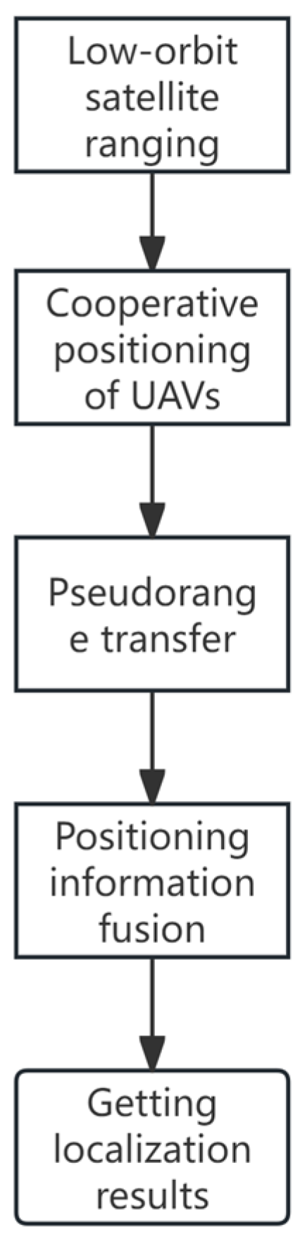
The overall implementation procedure of the proposed UCNCP algorithm is summarized as follows: Step 1: Establish the single-satellite pseudorange measurement model under the CSN communication–navigation integrated framework, and obtain raw pseudorange data between LEO satellites and UAVs. Step 2: Obtain inter-UAV ranging information through the wireless ranging module, and construct the cluster geometric topology. Step 3: Perform clock bias estimation and pseudorange error compensation based on the Newton iteration method. Step 4: Convert satellite positioning results and inter-UAV relative positioning results into three-dimensional Gaussian distributions. Step 5: Fuse all information based on information geometry to obtain the final stable 3D position of the UAV cluster.
A rigorous justification is provided as follows. The UAV cluster adopts high-precision GPS Disciplined Oscillator (GPSDO) for time synchronization, which guarantees that the intra-UAV clock offset is strictly bounded by 1 ns. Such a small offset introduces a maximum ranging error of only , which is negligible compared with the system positioning error and inter-UAV ranging error. Even if the clock offset slightly increases to 10 ns, the induced ranging error remains at the meter level and causes a positioning error degradation of less than 5%, indicating that the algorithm is robust to minor violations of this assumption. In contrast, the clock difference between a UAV and a LEO satellite is non-negligible due to factors such as link transmission delay and crystal oscillator deviation, which needs to be compensated through pseudorange measurement and algorithmic modeling.
It should be emphasized that the GPS Disciplined Oscillator (GPSDO) is only employed to achieve high-precision time synchronization within the UAV cluster, not for UAV positioning. The proposed UCNCP algorithm relies exclusively on pseudorange measurements from China Satellite Network (CSN) LEO satellites and inter-UAV ranging information, without using any GPS positioning results. Thus, the algorithm can operate independently when GPS signals are unavailable or interrupted.
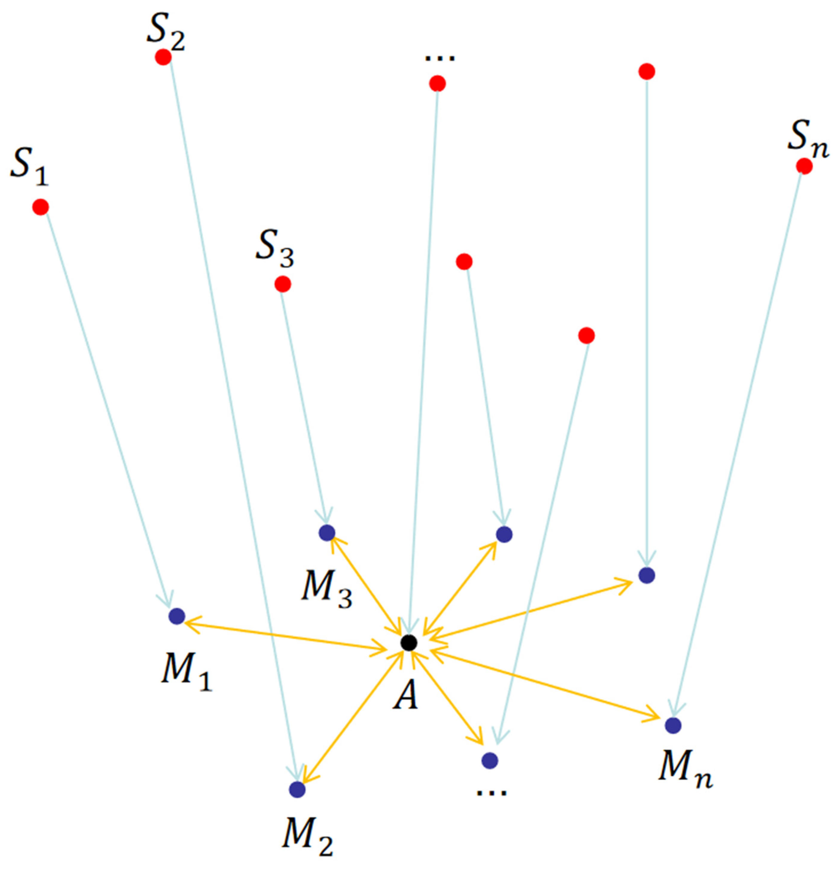
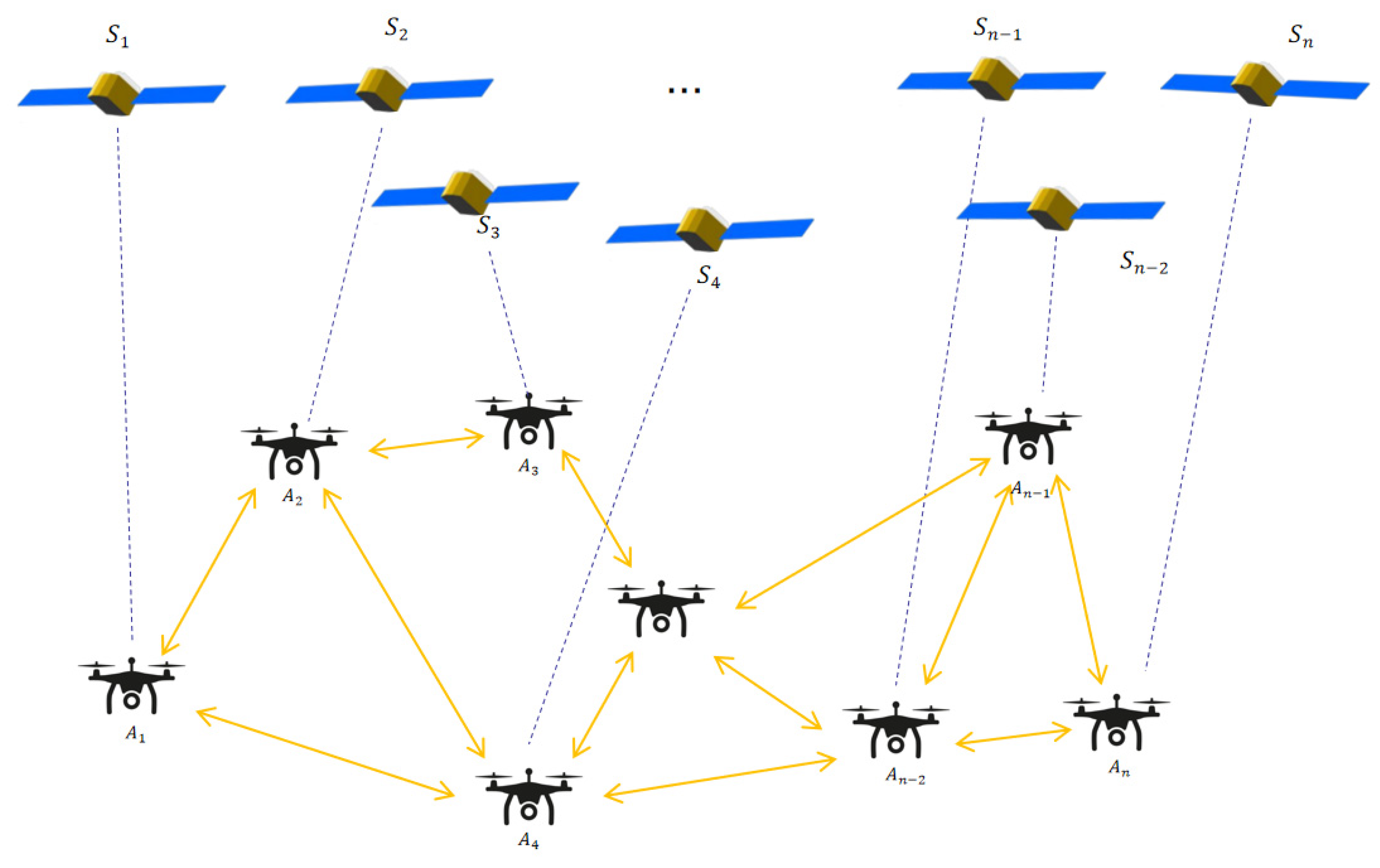
The UAV cluster cooperative positioning model under the CSN Integrated Sensing and Communications (ISAC) framework consists of a pseudorange calculation model under Integrated Communication and Navigation, and a cluster fusion positioning model based on information geometry, as illustrated in
Figure 1. During cooperative positioning within the UAV cluster, the time characteristics of the positioning information received by each UAV vary. Additionally, with the rapid movement of UAVs and LEO satellites, the cooperative status between each UAV and other UAVs, as well as the communication status with LEO satellites, change dynamically. The UAVs in the cluster are in a free aggregation–dispersion state, making it difficult to achieve time synchronization before fusing positioning results, thereby reducing the accuracy of cooperative positioning.
In the context of ISAC, satellites need to prioritize communication, resulting in short communication durations with UAVs. Furthermore, a single UAV can basically only establish a communication link with one satellite and rarely communicate with multiple satellites simultaneously. To achieve rapid fusion of real-time multi-navigation-source positioning information among multiple UAVs, this paper leverages the correlation between the covariance of UAV positioning information and positioning accuracy to establish a connection between the LEO satellite cluster and the UAV cluster. Specifically, by calculating the covariance matrix of positioning information accuracy, a UAV cluster cooperative positioning model under the CSN ISAC framework is established. Combined with inter-UAV distance measurement, rapid fusion positioning of large-scale UAV clusters is realized.
The information processing module of the UAV to be positioned converts positioning information from LEO constellations and other sources into corresponding information geometric models. By minimizing the average covariance, it fuses these models with the positioning information geometric models and ranging information of other communicable UAVs, thereby improving the positioning accuracy and stability of the entire UAV cluster network.
3.1. Pseudorange Calculation Model Under Integrated Sensing and Communications
A denotes the UAV to be positioned;
represent cooperative UAVs; and
denote China Satellite Network (CSN) LEO satellites. As illustrated in
Figure 2, due to the low orbital altitude and high operational speed of China Satellite Network satellites under the Integrated Sensing and Communications framework, a UAV can only communicate with one or two satellites within a short time window. Therefore, the positioning of the UAV can be determined by leveraging the pseudorange information from surrounding cooperative UAVs and the proposed cooperative algorithm.
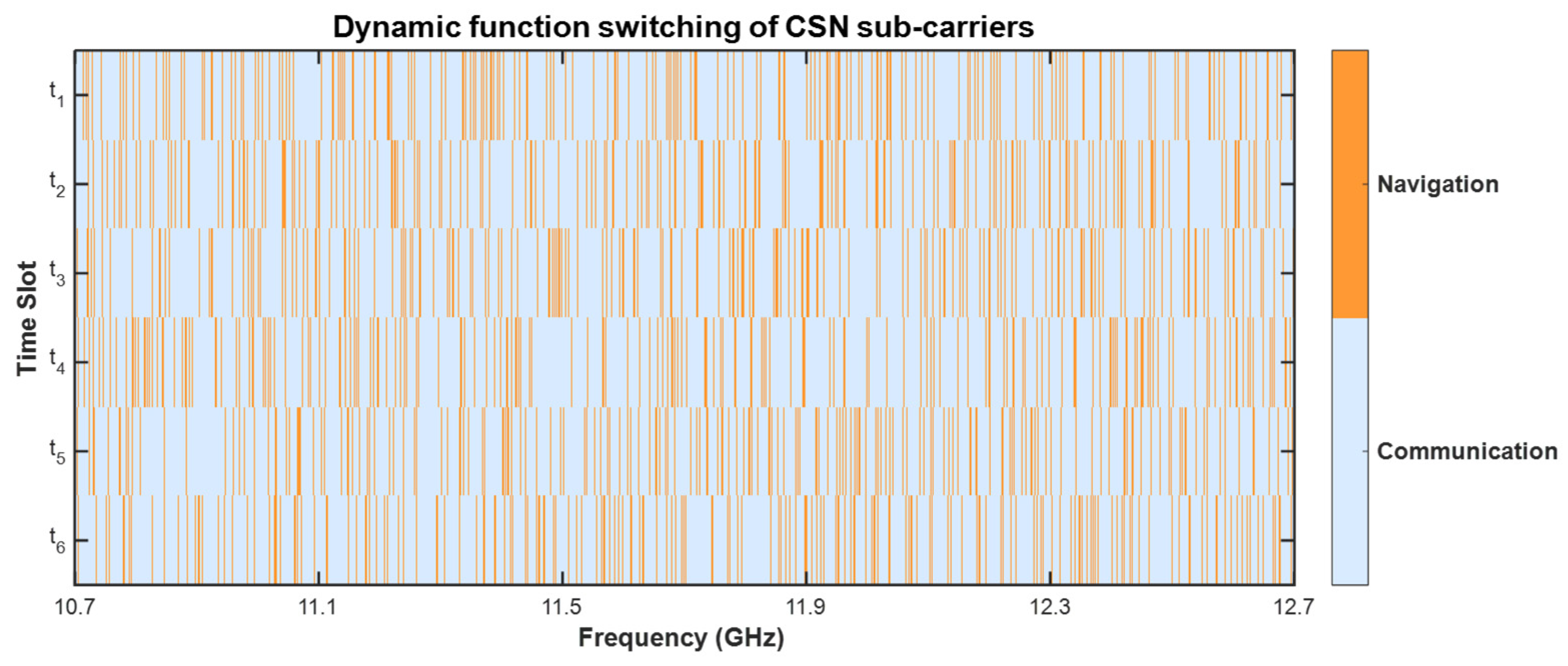
Notably, the China Satellite Network operates in a downlink frequency band of 10.7~12.7 GHz, which is divided into 2000 sub-carriers. Among these, 10–20% are dynamically allocated as navigation sub-carriers, while the remaining serve as communication sub-carriers, with the functional role of each sub-carrier switching dynamically, as shown in
Figure 3. The downlink frequency band is divided into communication sub-carriers and navigation sub-carriers, which are dynamically allocated over time. This dynamic frequency allocation is a core feature of the CSN Integrated Sensing and Communications (ISAC) framework, directly determining the validity and accuracy of pseudorange measurement—the foundation for subsequent pseudorange calculation. Specifically, pseudorange measurement relies on the stable reception of navigation signals carrying time and orbit information; only when a UAV locks onto a navigation sub-carrier with a fixed frequency can it decode the navigation message and accurately measure the signal propagation time. If the sub-carrier switches from navigation mode to communication mode during the measurement process, the UAV will lose access to valid navigation signals, resulting in interrupted pseudorange data acquisition. Even in the non-switching state, the frequency stability of navigation sub-carriers directly affects signal propagation characteristics: frequency drift of sub-carriers will cause phase deviations in the measured signal, which is closely related to the calculation of signal propagation time. Thus, the dynamic switching and stability of CSN frequency points are key factors determining the quality of pseudorange measurement.
Under navigation sub-carriers, the pseudorange is calculated as follows:
where the speed of electromagnetic wave propagation in a vacuum is constant c;
represents the signal propagation time offset between the satellite and UAV receiver, which characterizes the inherent time delay during satellite signal transmission; and
denotes the comprehensive measurement error, including satellite clock error, atmospheric delay error and random observation noise.
Since LEO satellites and UAVs belong to different clock systems and dynamic delays exist in link transmission, the clock difference between each UAV and the satellite is an independent variable. Herein, denotes the clock difference between the i-th UAV and the communicating LEO satellite, which must be jointly estimated through pseudorange measurement and Newton iteration. In contrast, clock calibration within the UAV cluster is accomplished via real-time communication, and the resulting clock difference is negligible, ensuring the temporal consistency of inter-UAV ranging data.
Assuming that the coordinates of the CSN satellites are , the true position coordinates of the UAV to be localized are . The coordinates of the surrounding cooperative positioning UAVs are , and the pseudorange information between the LEO star and the communicable UAV is .
Then the pseudorange information between each UAV and a satellite that can communicate is:
where
, and
denotes the geometric distance coefficient between the LEO satellite and the UAV observation node in the constructed positioning model.
Herein, denotes the geometric distance from the satellite to the i-th UAV, and is the equivalent distance error induced by this clock difference.
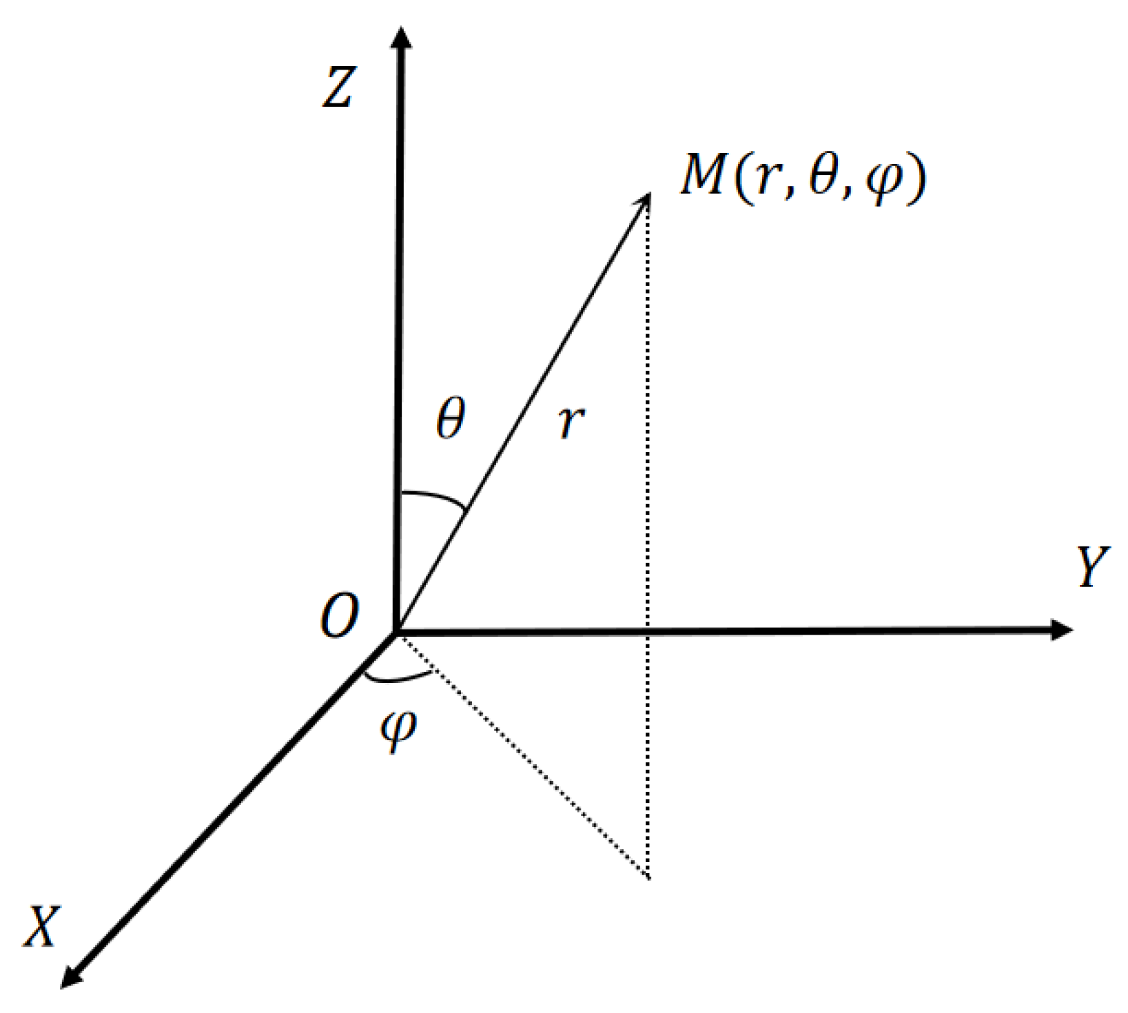
A spherical coordinate system is established with the UAV to be localized as the origin, as shown in
Figure 4.
The origin O of the spherical coordinate system in
Figure 4 is defined as the centroid of the LEO satellite constellation coverage center, which serves as the reference benchmark for subsequent spatial position calculation.
is the polar angle from the Z-axis;
is the azimuth angle in the XOY plane.
The position of the
synergistic UAV can be expressed as
.
where
is the ranging information and the variance is
,
is the angle formed by the half plane through the z-axis and point
with the coordinate plane ZOX, and
,
is the angle between the line segment
and the positive direction of the Z axis,
.
The use of spherical coordinates allows the pseudo-ranging information of the coordinated UAV to be transferred to the UAV to be tested via inter-UAV communication and solves for the position of the UAV to be tested.
Bringing Equation (3) above into Equation (2)
,
is the distance from the satellite to the UAV. Linearizing Equation (3) and solving the equation using Newton’s iterative method yields:
as well as
is the negative value of the partial derivative of in the x-direction at , is the computational result of the Newton iteration, and is the difference between the results of the two previous solutions during the Newton iteration in the three directions as well as the difference between the results of the two previous clock-difference solutions. It can be seen that the Jacobi matrix G is only related to the positional relationship between the LEO star and the UAV.
Solving Equation (4) using the least squares method yields
Then the result of localization after this Newton iteration is
When the error terms in the localization results and measurement data are retained, Equation (4) is rewritten as
where
is the pseudorange measurement error vector and
is the in-positioning and timing error caused by the pseudorange measurement error. After solving using the least squares method, we get
Assuming that the measurement errors
of individual LEO stars follow a Gaussian distribution with mean 0 and variance
, and that the measurement errors between satellites are uncorrelated, the covariance matrix of the localization results can be derived as:
Define as the weight matrix.
When the LEO satellite position coordinates and pseudorange measurements as well as errors are known, the positioning results can be calculated by Equations (7) and (8), and the covariance matrix of the positioning results can be calculated by Equation (11). Then the low-orbit constellation positioning result is:
where
is the LEO constellation positioning result and
is the covariance matrix of the LEO constellation positioning result.
The pseudorange calculation model under Integrated Communication and Navigation expands the pseudorange measurement from “single satellite—single UAV” to the joint pseudorange solution of “multiple cooperative UAVs—target UAV” through cooperative ranging within the UAV cluster. It enables 3D positioning without the need for multiple satellite links, adapting to the characteristic of CSN’s “dynamic switching between communication and navigation frequencies”. The pseudorange calculation can dynamically match the switching of the satellite’s navigation function. By means of clock difference modeling, Newton iteration linearization, and covariance quantification, it reduces the interference of time asynchrony and measurement noise with positioning accuracy.
3.2. Information Geometry-Based Cluster Cooperative Positioning
The initial coordinate data for collaborative positioning among drones in a drone cluster is sourced from China Star Network Satellite Navigation and Positioning. The localization result a of the localization UAV satisfies three-dimensional Gaussian distribution with mean and covariance matrix ; the number of communicable UAVs that can participate in cooperative positioning is n; and the position and covariance matrix of the co-located UAV are and , respectively.
From Equation (3), the mean
and variance
of the estimate
of the coordinated UAV
to be localized
are respectively
In Equation (13), is the diagonal matrix constructor.
At this time, the localization information about the UAV to be localized includes the low-orbit constellation localization result
and the covariance matrix
as well as the mean value
and the covariance matrix
of the estimated value
of the coordinated UAV
for the UAV to be localized
. Here, diag(·) denotes the diagonal matrix operator that constructs a diagonal matrix from the input vector elements. where the localization result
and
obey the three-dimensional Gaussian distribution, the Gaussian distributed geometric probability function of
is:
In Equation (14), x denotes the three-dimensional position vector of the UAV to be localized,
is the mean vector of the LEO constellation positioning result,
is a constant term related to the mean and covariance of the LEO constellation positioning results, which does not affect the positioning optimization process, and
is the constant term:
Then the joint probability density function of the localization information containing the low-orbit constellation localization information
and the estimate
of the coordinated UAVs to be localized UAVs is:
In Equation (16), is the localization estimation result of the target UAV by the coordinated UAV , is the covariance matrix of the localization estimation result of the target UAV by the coordinated UAV , is the localization result of the target UAV by the low-orbit constellation, is the covariance matrix of the localization result by the low-orbit constellation, and are constant terms, and is the localization result of the fusion of the multiple navigation sources.
The covariance matrix of the localization information after fusion of multiple navigation sources is:
By comparing Equations (13) and (15), it can be seen that the localization results after the fusion of multiple navigation sources satisfy the three-dimensional Gaussian distribution:
where n denotes the number of cooperative UAVs involved in the positioning fusion process. Solving Equation (17) yields
The UCNCP algorithm converts the satellite pseudorange information of each UAV and the ranging information between adjacent UAVs into probability density functions of three-dimensional Gaussian distributions, where the mean value represents the positioning estimation and the covariance matrix reflects the estimation uncertainty.
Through Equations (17) and (19), the inverse of the covariance matrix is used as the weight, which automatically assigns higher weights to high-precision information. When the satellite signal mutates (i.e., instantaneous attenuation, interruption, or jitter caused by UAV rapid maneuvering and line-of-sight variation), increases and its weight decreases, while the weight of the ranging information between adjacent UAVs is automatically enhanced, thereby suppressing the propagation of mutation errors. This mechanism is not possessed by traditional algorithms: the conventional UKF requires manual adjustment of the process noise Q to adapt to error changes, which is prone to parameter tuning difficulties.
4. Testing and Analysis of Results
This section validates the UAV cluster cooperative positioning method under the China Satellite Network (CSN) Integrated Sensing and Communications (ISAC) framework from the perspectives of positioning accuracy and stability.
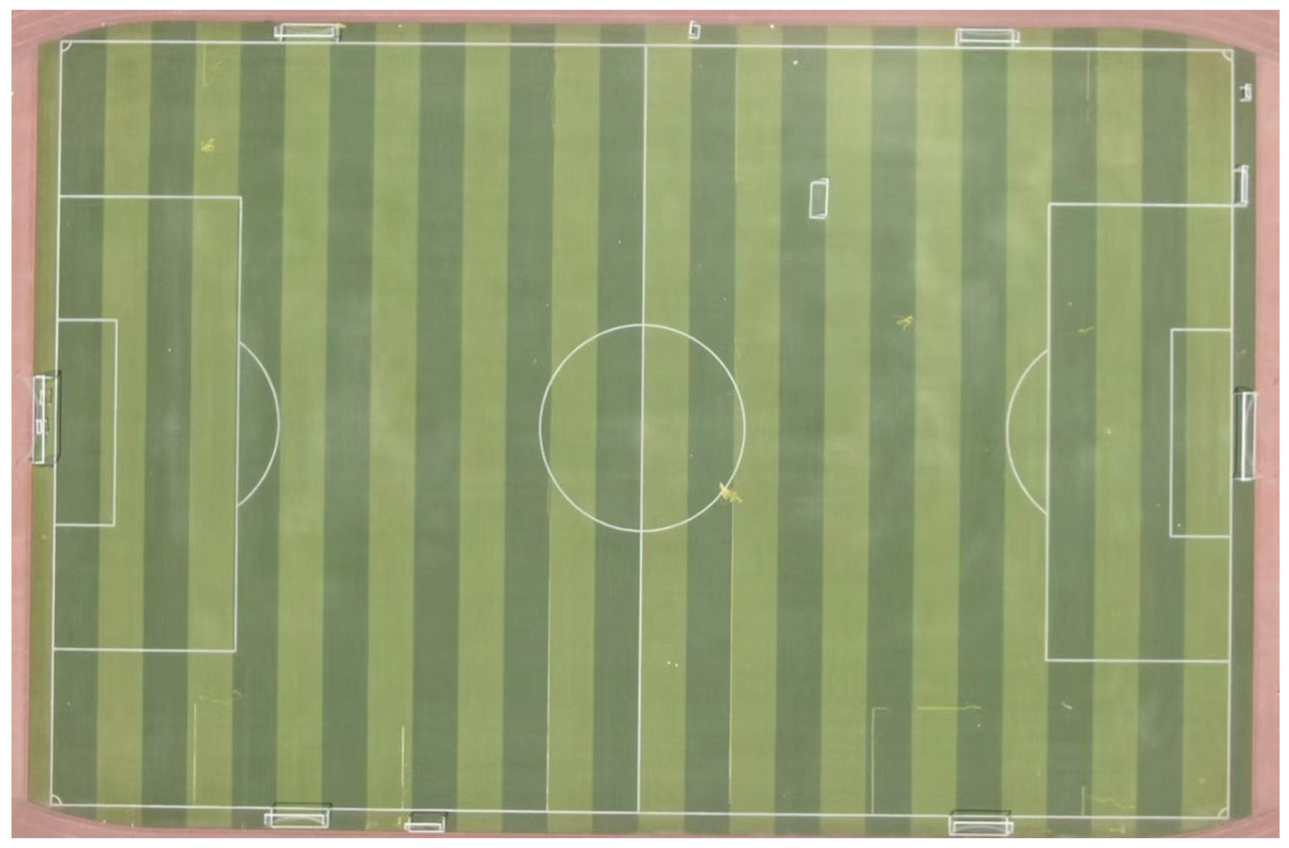
The experiments described in this section are field tests based on real satellite signals from the China Satellite Network. The test area is a 100 × 100 × 50 m open space within the Chang’an Campus of Northwestern Polytechnical University. The open test site without tall buildings is selected to ensure stable CSN signal reception and accurate ground truth calibration, which is necessary for quantitative comparison and algorithm verification. Validation under urban canyon conditions will be conducted in the future. The core reasons for selecting this restricted space are as follows:
- (1)
Avoiding airspace control and complying with civil UAV flight safety regulations.
- (2)
No tall buildings blocking the site, ensuring stable reception of CSN satellite signals (satellite visibility ≥ 90% during the experiment).
- (3)
Facilitating the deployment of laser rangefinders for ground truth calibration. Throughout the experiments, real CSN LEO satellite links and a physical UAV cluster are utilized to verify the feasibility and superiority of the proposed UCNCP algorithm in practical scenarios, which is one of the key innovations of this paper.
The core hardware specifications for this test are listed in
Table 1 below.
The UAV platform and ranging hardware parameters are shown in
Table 2.
The ground truth position of each UAV was provided by a high-precision RTK-GPS module with centimeter-level positioning accuracy. During the experiment, the RTK-GPS system recorded real-time position data at 10 Hz, which was time-synchronized with the proposed algorithm. The positioning error was calculated as the Euclidean distance between the estimated position and the RTK-GPS reference position.
Given that certain technical parameters of the China Satellite Network (CSN) are subject to confidentiality requirements, information such as the satellite identification numbers and specific orbital parameters used in the experiments has been processed in compliance with relevant regulations. The core test conditions (e.g., frequency band, bandwidth, sampling rate) were all configured based on the publicly available technical specifications of CSN LEO satellites, ensuring the reproducibility of the experimental results. For further verification of hardware details, the corresponding author can be contacted to obtain the compliance-certified test report.
For performance reference, the GPS-based positioning result is taken as the ground truth with centimeter-level accuracy. The proposed UCNCP algorithm achieves reliable positioning using only CSN LEO signals and inter-UAV ranging, showing strong practical value in environments where GPS signals are blocked, interfered with, or unavailable.
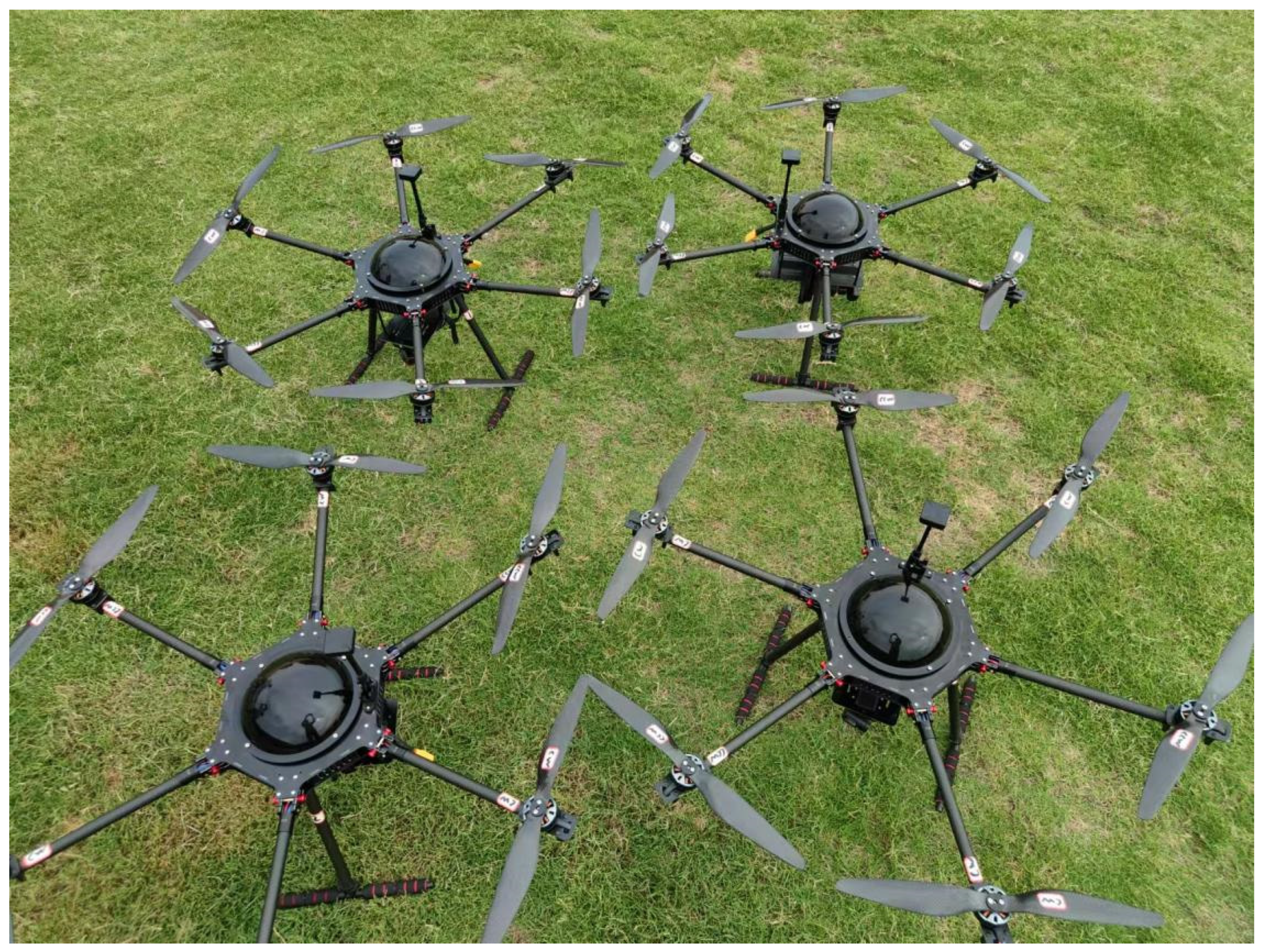
The UAV cluster deployed in the experiments consisted of six UAVs, adopting a triangular topology. Each UAV maintained stable ranging links with at least two adjacent UAVs. All hardware devices underwent a 72 h continuous operation test prior to the formal experiments, thus ensuring that no data anomalies were caused by hardware malfunctions.
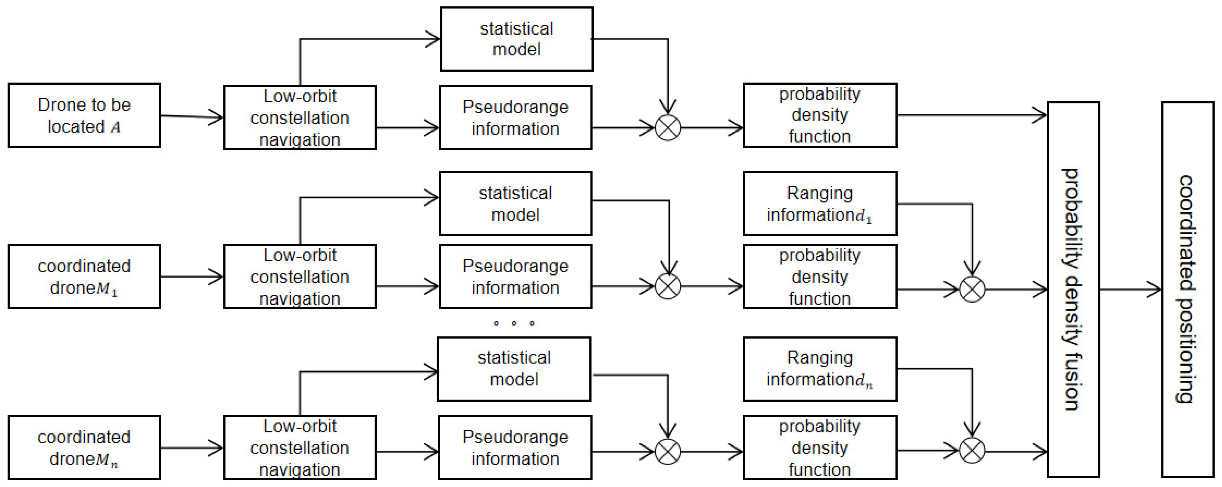
A block diagram of the positioning process for a single UAV is illustrated in
Figure 8.
The process includes satellite pseudorange acquisition, inter-UAV ranging transfer, and information fusion positioning.
A flowchart of the information geometry-based UAV cluster fusion localization model is shown in
Figure 9.
4.1. Linear Flight Trajectory Test Scenario
The X/Y/Z axes represent the horizontal, lateral, and vertical positions of UAVs, respectively (unit: m).
To verify the effectiveness of the proposed UAV cluster cooperative positioning method under the China Satellite Network Integrated Sensing and Communications framework, four representative positioning algorithms are selected for comparison and analysis, including Recursive Least Squares (RLS), Unscented Kalman Filter (UKF), Convolutional Neural Network (CNN), and the proposed Unmanned Aerial Vehicle Cluster Communication–Navigation Integrated Cooperative Positioning (UCNCP) algorithm.
(1) Recursive Least Squares (RLS) is a classic parameter estimation method widely used in linear satellite positioning and target tracking scenarios.
(2) Unscented Kalman Filter (UKF) is the most mainstream nonlinear filtering method for multi-source navigation fusion and UAV positioning.
(3) Convolutional Neural Network (CNN) is a typical data-driven method that can suppress positioning error jitter in complex motion environments.
To ensure fair comparison, all benchmark algorithms are implemented with standard configurations widely adopted in the UAV positioning and satellite navigation literature. The details of the settings are as follows:
(1) Recursive Least Squares (RLS): The RLS algorithm adopts a first-order linear dynamic model. The forgetting factor is set to , and the initial covariance matrix is , where I denotes the identity matrix. The state vector includes 3-D position information of UAVs, and the observation vector is derived from pseudorange measurements.
(2) Unscented Kalman Filter (UKF): The UKF uses a 3D constant-velocity motion model. The process noise covariance matrix is , and the measurement noise covariance matrix is . Sigma-point parameters are set as , , , which are typical values for UAV positioning systems.
(3) Convolutional Neural Network (CNN): The CNN model consists of two convolutional layers, two max-pooling layers, and one fully connected layer. The input is sequential positioning and ranging data, and the output is the estimated UAV position. The network is trained by an Adam optimizer with a learning rate of 0.001 and a batch size of 32.
All parameters are fixed during all experiments to ensure the comparability of positioning performance under different trajectories.
These methods are selected as comparison benchmarks because they cover three typical technical categories: classical estimation, filtering-based fusion, and data-driven learning. They are the most representative and widely adopted approaches in the field of UAV cooperative positioning and LEO satellite navigation, ensuring the rationality and persuasiveness of the comparison results.
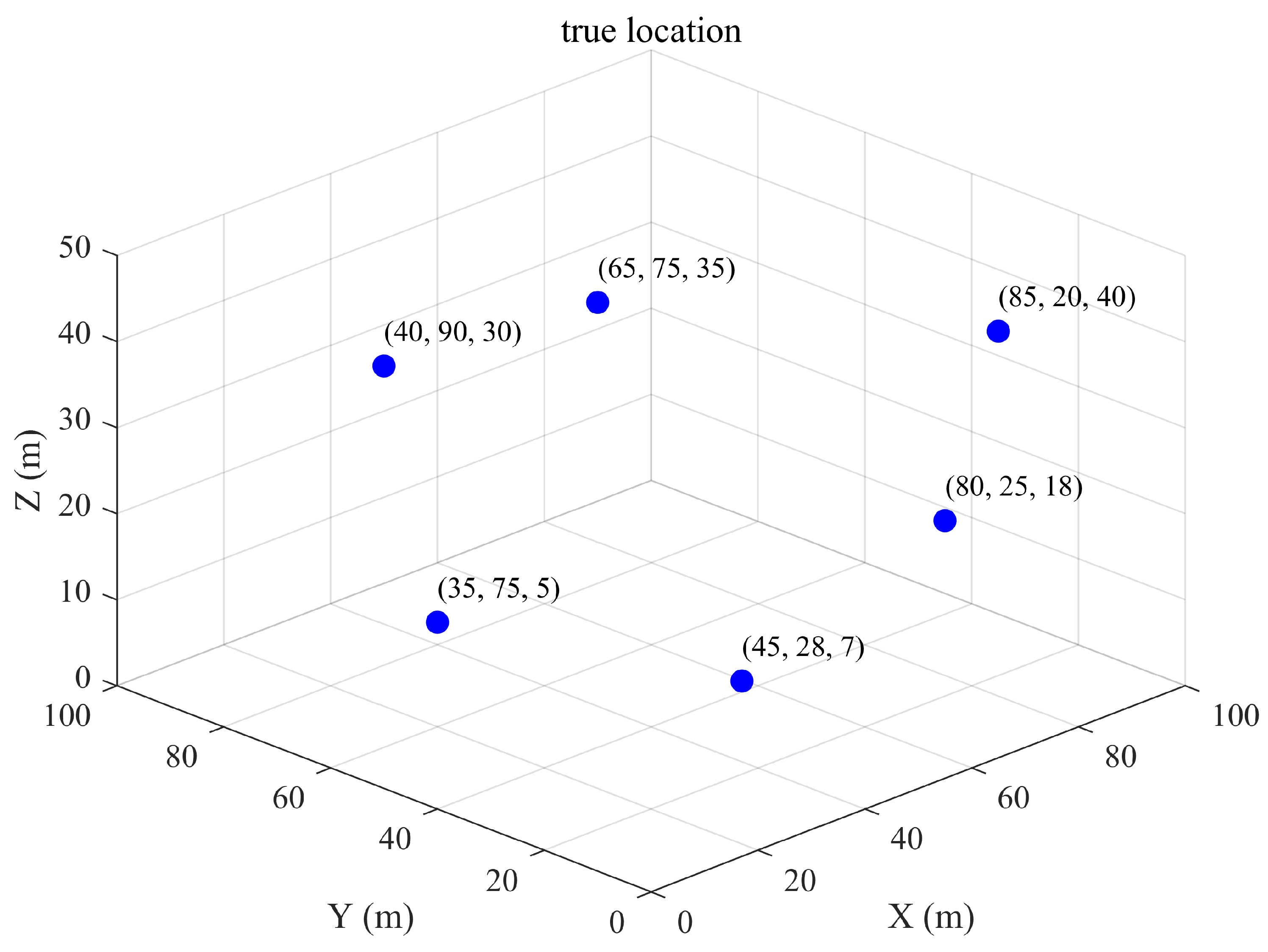
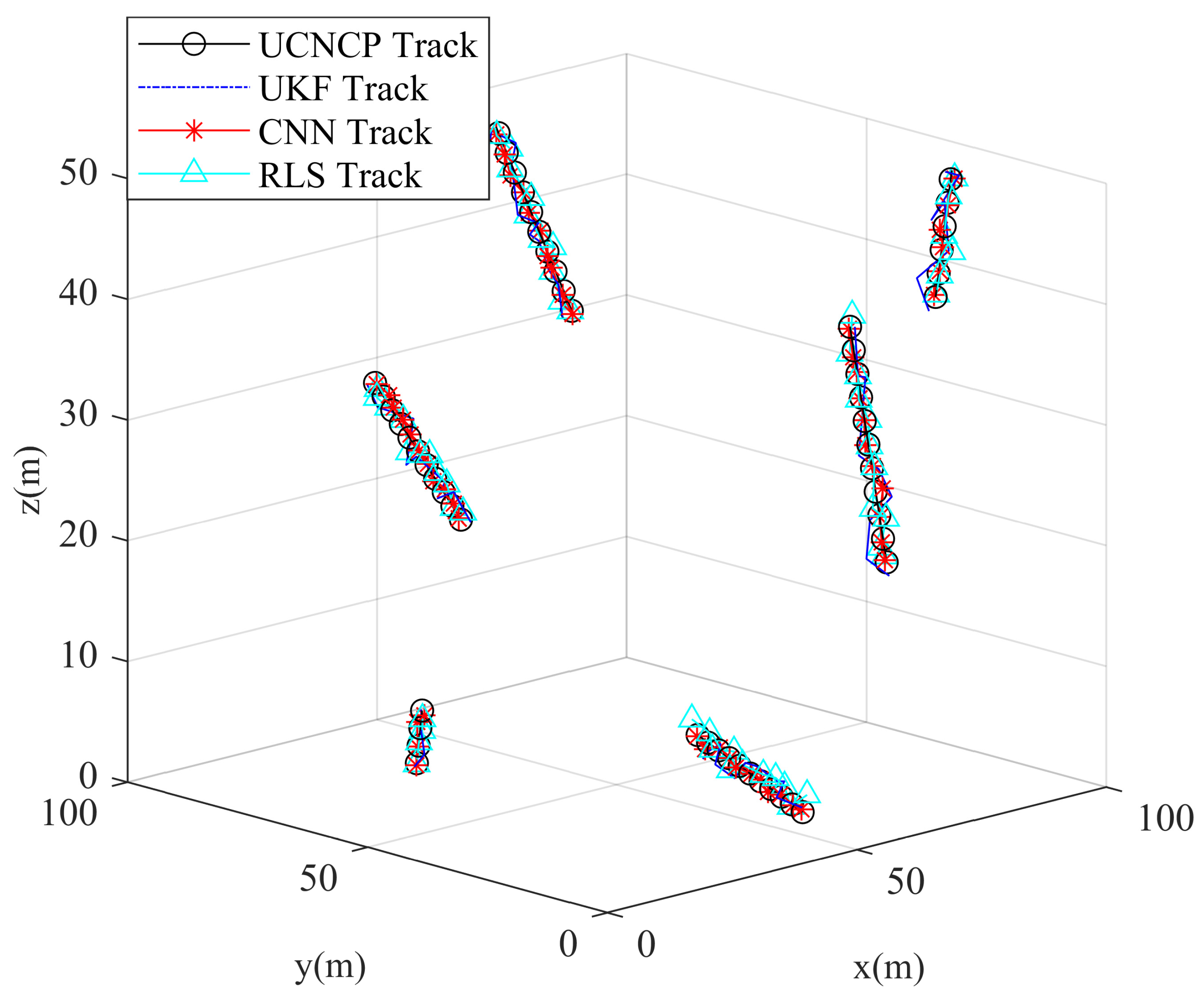
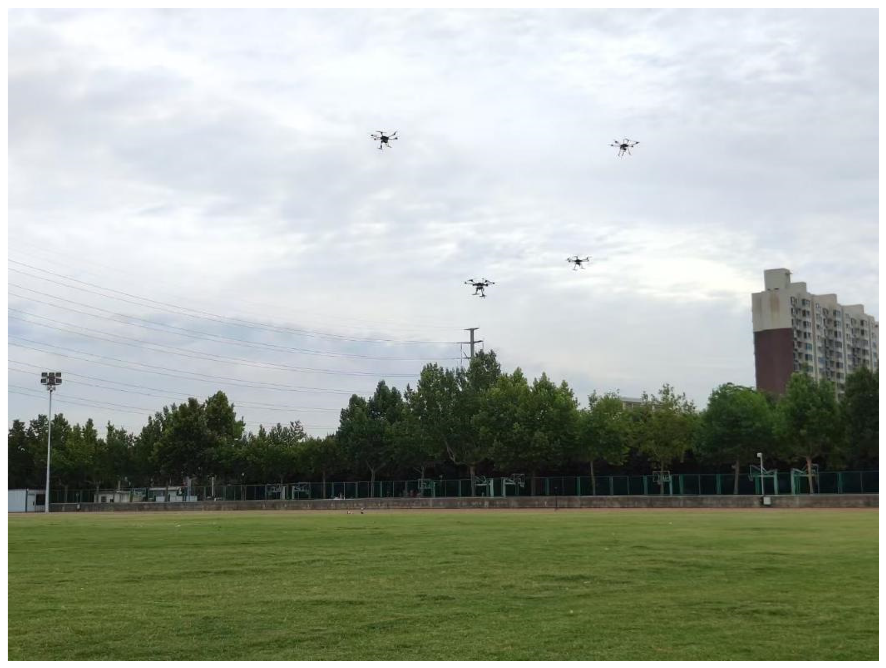
In the experiments, six initial true positions of a six-UAV cluster were selected within the test space, as illustrated in
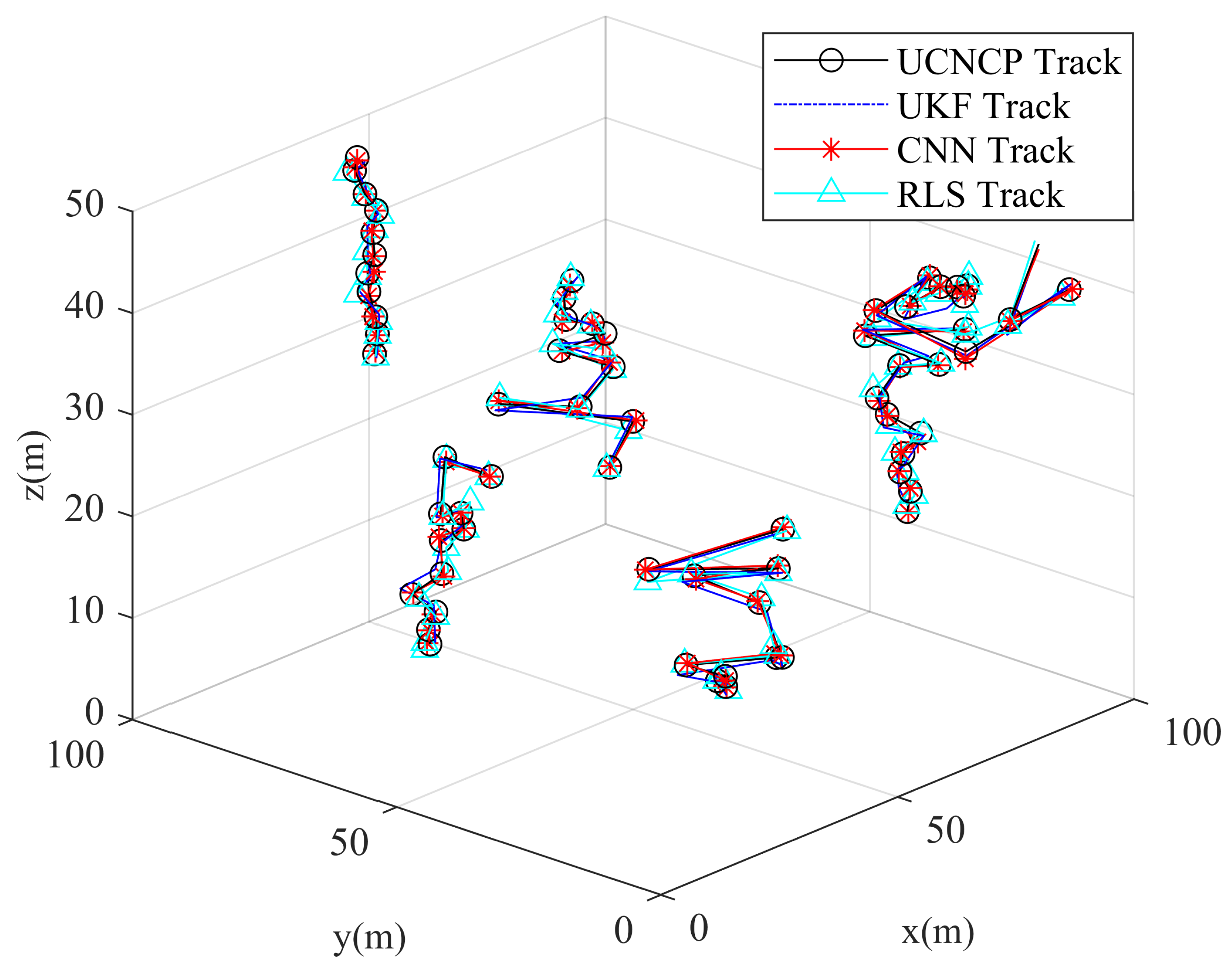
Figure 10. The UAVs moved in uniform linear motion with random directions, and the final positioning trajectory results are presented in
Figure 11.
In
Figure 11, the symbol “o” denotes the positioning results obtained by the UCNCP method. This figure intuitively presents the complete motion trajectory of UAVs in the experimental scenario, which helps readers understand the dynamic variation characteristics of the cluster. It can be observed that the UAV positioning results from the UCNCP method are in close agreement with the true values. As shown in the results of
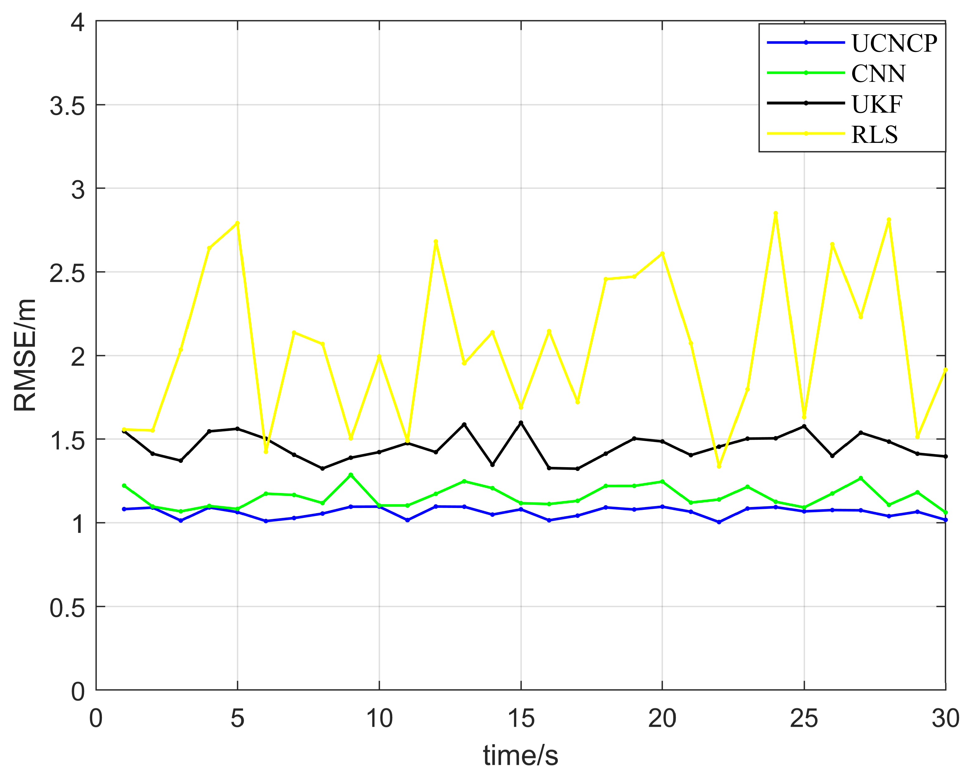
Figure 12, in the absence of mutation errors, the RLS and UKF methods yield relatively large positioning errors, followed by the CNN method, while the UCNCP method achieves the smallest errors. This
Figure 12 reflects the operation state variation of UAVs, providing auxiliary support for the rationality of the experimental setup. This result indicates that, compared with the other three methods, the UCNCP method can provide higher positioning accuracy under normal conditions, with an average positioning error of only 1.09 m, which is lower than that of the other methods. At t = 9 s, the average positioning error of the UKF method is 1.37 m, whereas that of the UCNCP method is 1.1 m, demonstrating that the UCNCP method converges more rapidly. In comparison with the UKF method, the UCNCP method improves the average positioning accuracy by 28%. This method can better fuse the ranging information between UAVs, thereby yielding more accurate positioning results.
This rapid convergence is attributed to the information geometry fusion mechanism of the UCNCP algorithm, which avoids linearization errors inherent in traditional methods such as UKF and RLS. Unlike filter-based algorithms that rely on linearization or unscented transformation of state and observation equations, the UCNCP algorithm directly models positioning information as three-dimensional Gaussian distributions and fuses them through probability density function transformation. This eliminates errors caused by approximate linearization of non-linear systems, enabling faster convergence to accurate positioning results in uniform linear motion scenarios.
4.2. Piecewise Linear Trajectory Test Scenario
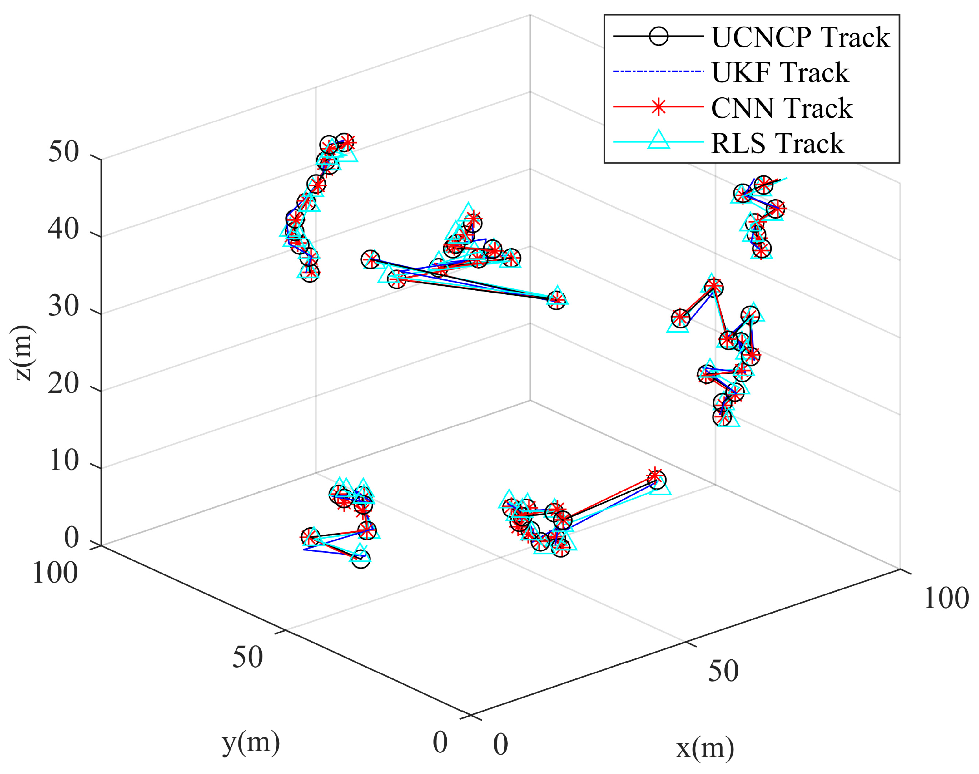
In most scenarios where UAV clusters perform regular missions, their motion is non-linear. Therefore, field tests were conducted on a six-UAV cluster with piecewise linear trajectory motion, and the resulting positioning trajectories are presented in
Figure 13. Owing to the irregular motion of the UAVs, all positioning errors exhibited an increasing trend.
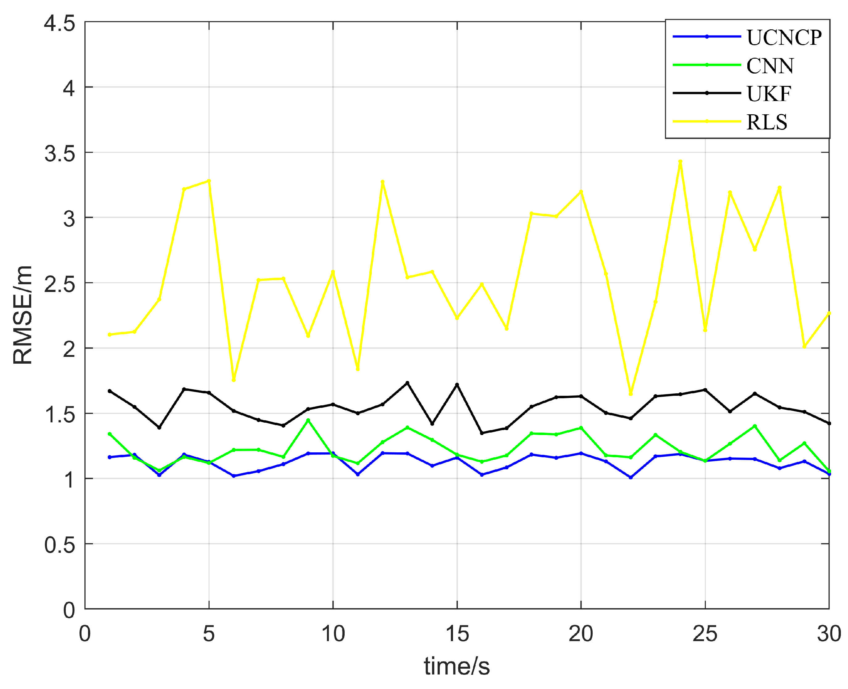
As indicated by the results in
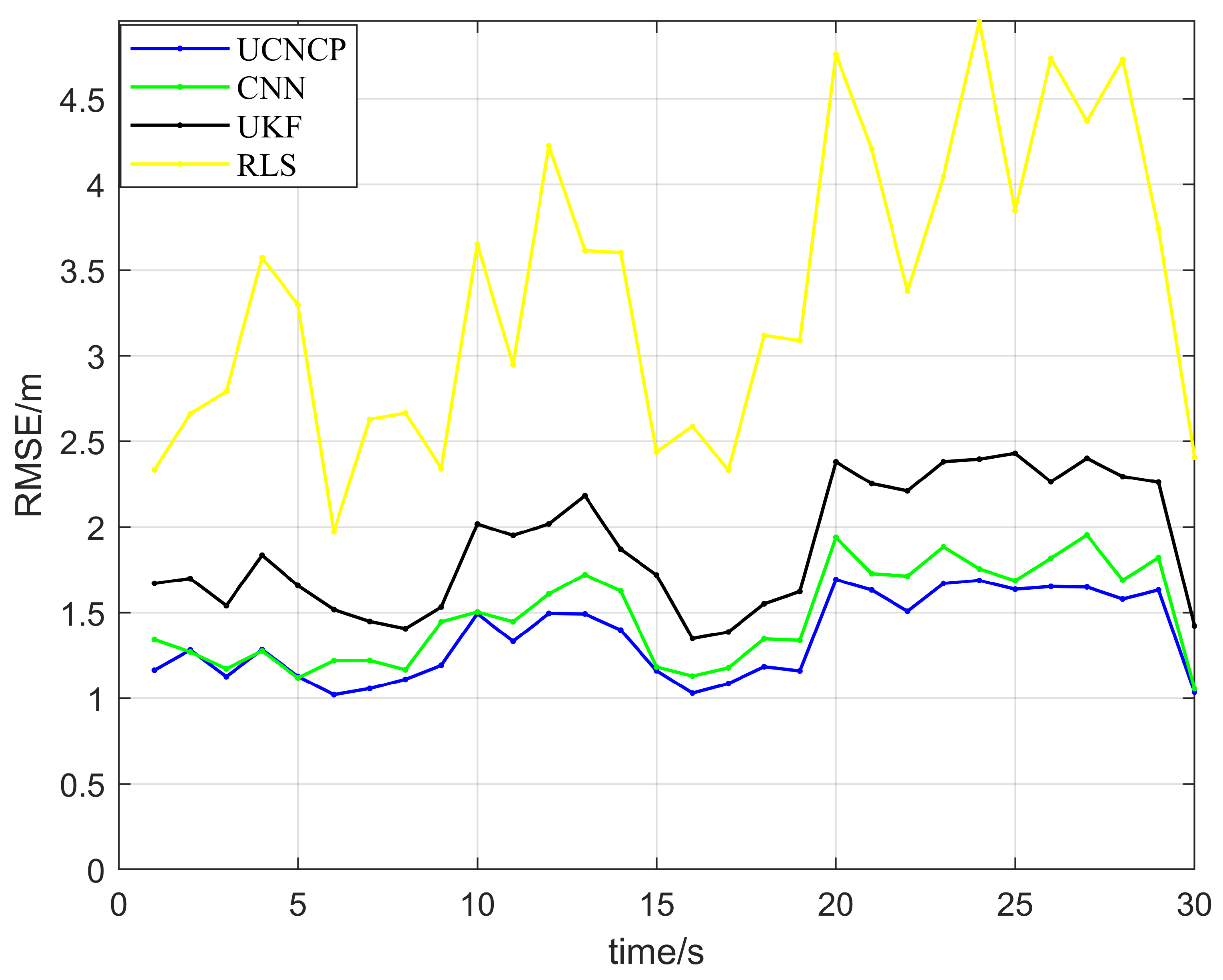
Figure 14, compared with uniform linear motion, the positioning errors of all methods increased due to the complex motion of the UAVs. The RLS method exhibited the largest error variation, while the UCNCP method showed the smallest variation. At t = 13 s, the average positioning error of the UKF method was 1.41 m, and that of the UCNCP method was 1.15 m. In comparison with the UKF method, the UCNCP method improved the average positioning accuracy by 30%. This result demonstrates that, under the Integrated Sensing and Communications (ISAC) framework, the UCNCP method can deliver higher positioning accuracy and stability when UAV clusters execute complex motions. It achieves more accurate positioning results by better fusing the ranging information among UAVs.
The minimal error fluctuation of the UCNCP algorithm under complex polygonal motion is mainly due to the compensation effect of intra-cluster ranging information on satellite signal instability. In polygonal trajectory motion, the dynamic change in UAV positions leads to intermittent satellite signal reception and unstable pseudorange measurement. However, the UCNCP algorithm constructs a real-time fusion architecture based on inter-UAV ranging, which supplements the positioning information gap caused by unstable satellite signals. By fusing high-precision ranging data between adjacent UAVs with satellite pseudorange measurements, the algorithm effectively offsets the positioning error caused by satellite signal fluctuations, thus maintaining stable positioning performance in complex motion scenarios.
4.3. Abrupt Piecewise Linear Trajectory Test Scenario
In the actual motion process of UAV clusters, environmental factors such as electromagnetic interference and occlusion by high-rise buildings can affect both the positioning of navigation sources and the communication links between UAVs. These factors may lead to communication interruptions or signal attenuation, which in turn trigger mutation errors. Such mutation errors not only degrade the positioning accuracy of individual UAVs but also exert a negative impact on the cooperative operation capability of the entire cluster. Therefore, it is necessary to conduct in-depth research on positioning methods under such mutation scenarios. Field experiments were conducted to verify the positioning performance of the UCNCP method in mutation-prone environments. Four different positioning methods were adopted in the tests: the RLS, UKF, CNN, and UCNCP methods. The six-UAV cluster moved randomly in arbitrary directions, and the final positioning trajectory results are presented in
Figure 15.
As can be seen from the results in
Figure 16, the UAV cluster encountered three navigation information mutation events. The most prominent performance degradation was observed in the two traditional methods, namely the Recursive Least Squares (RLS) and Unscented Kalman Filter (UKF) methods, which exhibited significant jitter in positioning errors. In comparison, although the neural network method showed improved jitter in positioning errors, and the Convolutional Neural Network (CNN) method demonstrated certain advantages in processing complex data, its robustness and stability were still insufficient when confronted with mutation environments. This resulted in relatively high positioning errors and a noticeable jitter amplitude. In contrast, the UCNCP method exhibited outstanding performance, with minimal jitter in positioning errors, indicating that it possesses stronger robustness against signal mutation and dynamic motion variations. Through a distributed mechanism, the UCNCP method can effectively suppress external interference and adjust positioning strategies in a timely manner, thereby maintaining high positioning accuracy. Based on these experimental data, it can be concluded that the UCNCP method is significantly superior to the traditional RLS and UKF methods, as well as the CNN method, in coping with mutation errors.
The core principle of the UCNCP algorithm in suppressing error propagation during navigation information mutations lies in the dynamic weight adjustment mechanism based on covariance matrices. When satellite signals mutate, the covariance matrix () of the LEO constellation positioning results increases significantly, leading to a decrease in its weight () in the fusion process. Meanwhile, the UCNCP algorithm automatically enhances the weight of intra-cluster ranging information, which is less affected by external mutations. This dynamic weight allocation mechanism effectively isolates the impact of mutation errors from satellite signals, preventing error propagation to the entire cluster’s positioning results. In contrast, traditional methods such as RLS and UKF lack adaptive weight adjustment capabilities, resulting in significant error jitter when facing sudden signal changes.
A sensitivity analysis of intra-cluster synchronization errors is conducted. When the intra-UAV clock offset increases from 1 ns to 10 ns, the positioning error only rises by less than 5%, which demonstrates that the proposed algorithm maintains satisfactory robustness against synchronization imperfections. Even if the clock offset further increases to 50 ns, the positioning performance remains stable and significantly outperforms traditional methods, verifying the practicality of the proposed approach under non-ideal synchronization conditions.
In addition to positioning accuracy and stability, the real-time performance and computational characteristics of the UCNCP algorithm are analyzed as follows. The proposed algorithm adopts information geometric fusion with a closed-form solution, which avoids complex iterative optimization and nonlinear sampling operations. The computational complexity of the fusion module is , where denotes the number of cooperative UAVs. The average runtime latency is less than 20 ms under the embedded UAV platform, which fully satisfies the 10 Hz navigation update requirement. The processor load and memory usage remain at a low level suitable for real-time UAV flight control. The communication overhead only involves inter-UAV ranging data and lightweight pseudorange information, which increases linearly rather than exponentially with the cluster size. Thus, the algorithm maintains good scalability even as the number of UAVs increases. The communication update interval is consistent with the navigation update rate (100 ms), meeting the real-time deadline constraints of UAV cluster systems. These results show that the UCNCP algorithm achieves high positioning performance while satisfying the critical requirements of real-time performance, computational efficiency, communication overhead, and scalability for practical embedded UAV systems.
To quantitatively compare the positioning performance of different algorithms, the RMSE, maximum error and minimum error under three typical trajectories are summarized in
Table 3. All data are extracted from the experimental error curves.
5. Conclusions
To address the issues of fewer positioning links from the China Satellite Network (CSN) under the Integrated Sensing and Communications (ISAC) framework and asynchronous information fusion time for positioning in UAV clusters, we propose an Unmanned Aerial Vehicle Cluster Communication–Navigation Integrated Cooperative Positioning (UCNCP) algorithm. Combining the communication and navigation characteristics of the CSN, we establish a single pseudorange measurement model and a cluster geometric topology, and construct a cooperative positioning framework fusing satellite pseudorange measurements and inter-UAV ranging data to realize navigation and positioning for UAV clusters.
The positioning accuracy of the UAV cluster was tested under three scenarios: ideal trajectory, abrupt piecewise linear trajectory, and complex mutated trajectory. Comparative validation with existing UAV cluster positioning methods demonstrates that the proposed UCNCP algorithm can mitigate the impact of mutation errors on positioning accuracy when navigation information is disrupted, improving the positioning stability of the UAV cluster by more than 30%.
This method can be applied to various civil fields, including logistics distribution, surveying and geographic information collection, emergency rescue, and atmospheric environmental monitoring, to enhance the collaborative efficiency of UAVs. However, there remains room for improvement in future research. As the number of UAVs in the cluster increases, the volume of data grows exponentially. Thus, determining how to quickly and accurately screen valid data has become a key factor in improving positioning performance. Future work will focus on optimizing data screening strategies for large-scale UAV clusters.
The proposed UCNCP algorithm only requires inter-UAV synchronization and can operate independently without GPS signals, making it a highly reliable backup solution in challenging environments.
Notably, the experiments were conducted in an open space without tall building occlusion. Future tests should be carried out in urban canyon environments to verify the algorithm’s performance under severe signal blockage.
In terms of operational safety and security for rescue, logistics, and monitoring applications, the proposed UCNCP algorithm provides inherent reliability support. The positioning integrity is guaranteed by the covariance matrix in the information geometry fusion framework, which quantifies the confidence interval and real-time error bounds. Fault detection and isolation are realized by monitoring abnormal residuals and sudden changes in the covariance; once satellite faults or interference is detected, the algorithm can automatically reduce the weight of satellite signals and switch to a safe degradation mode relying mainly on inter-UAV ranging. This mechanism ensures continuous navigation capability even under signal interruption or electromagnetic interference. In the future, we will further enhance the anti-interference and security capabilities to meet stricter safety requirements in critical missions.