Extended Abstract

Modeling and Mitigation of Noise on the A23 Motorway Using GIS †

by
António Carvalho
1,2,3,
Victor Cavaleiro
2,3,
António Albuquerque
3,4 and
Flora Silva
4,5,*
1
Geo4Health, Ed. UBIMedical, EM506, 6200-284 Covilhã, Portugal
2
GeoBioTec, Calçada Fonte do Lameiro, 6201-001 Covilhã, Portugal
3
Department of Civil Engineering and Architecture, University of Beira Interior, Calçada Fonte do Lameiro, 6201-001 Covilhã, Portugal
4
FibEnTech, Rua Marquês D’Ávila e Bolama, 6201-001 Covilhã, Portugal
5
School of Technology and Management, Polytechnic Institute of Bragança, Campus de Santa Apolónia, 5300-253 Bragança, Portugal
*
Author to whom correspondence should be addressed.
Presented at Environment, Green Technology and Engineering International Conference (EGTEIC 2018), Caceres, Spain, 18–20 June 2018.
Proceedings 2018, 2(20), 1306; https://doi.org/10.3390/proceedings2201306
Published: 18 October 2018

Abstract

:
Rendering at the European Directive 2002/49/EC, all EU members have to draw up a strategic noise map for all agglomerations with more than 250,000 inhabitants and for all major airports, roads and railways. A study of environmental impact assessment on motorway A23 in the stretch between Castelo Branco–Alcains (Portugal), based in the impact of the environmental noise, allowed the modeling the noise variation, which can be useful for establishing mitigation measures. The results show that noise model can be a useful tool for the monitoring noise impact in surrounding of motorways.

1. Introduction

Noise is recurrently designated as “unwanted sound”, and, within this context, environmental noise is normally present in some form in all areas of human, animal, or environmental activity. The effects in humans of exposure to environmental noise may vary from emotional to physiological and psychological [1]. Studies have shown that the European citizens, in 2000, were exposed to noise from road traffic with a total equivalent sound pressure level (L) exceeding 55 dB(A) in more than 44% of the population, i.e., around 210 million people [2,3].
The exposure to high noise levels can result not only in auditory consequences, but also in hearing loss, as well as non-auditory consequences, such as sleep disorders, mental illness, anxiety, problems with speech intelligibility, physical performance [4].
The Commission of the European Community published the Directive 2002/49/EC [5], to response at all these adverse effects. With this legislative instrument, the European Union (EU) sought to develop a common strategy to mitigate noise pollution. EU Member States were obliged to draw up a strategic noise map, at the latest by 30 June 2007, and the corresponding action plans, 18 July 2008, at the latest for all agglomerations with more than 250,000 inhabitants and for all major airports, roads and railways. It recommends the use of harmonized noise indicators in accordance with the NP ISO 1996-1 of 2003 [5,6]. The present study aims to perform the modeling and characterization of environmental noise for the A23 motorway in the section between Castelo Branco and Alcains (Portugal) using commercial noise forecasting software to contribute to its mitigation.

2. Materials and Methods

The method of calculating the model for indicators, for road traffic noise, is the French calculation method NMPB-Routes-96 (French standard XPS 31-133, [7]). As regards the entry data, these documents refer to the Guide du bruit des transports terrestres, fascicule prévision des niveaux sonores, CETUR, 1980. In the measurements of ambient noise it was used the Sonometer Analyzer Class 1—RION NA-27, to validate and georeferentiation all the inventoried elements with the aid of a GPS based equipment South RTK-S86T and rover South RTK-S82T. Noise modeling was performed using DataKustik’s Cadna A software, in accordance with the rules imposed by the Commission of the European Community. The maps generated through the modeling software, Cadna A, were elaborated under cartographic elements in digital format of the 1:5000 charts, namely the quoted points and contours, road axis, buildings and height of the building, and land use. For the validation of the created maps, in situ measurements were carried out in 5 points, distributed in the subsections.
A digital terrain model (DTM) of a broad area in the surroundings of the infrastructure was developed. Later the noise maps to scale 1:2000 with a 500 m buffer through the modeling software Cadna A. All relevant data for the calculation of noise maps were introduced in modeling process, namely the characteristics of the route, taking into consideration the type of floor and the track class, speed of movement of vehicles, average daily traffic, and noise barriers. Traffic volumes of section under study were provided by the infrastructure concessionaire and treated in such a way that they can be introduced in the model. It was thus calculated the average daily traffic for an annual period, and then removed the corresponding average daily traffic values (Table 1).
The existing noise barriers along the A23 are Galvanized steel with glass wool 70 kg m−3, have an extension of 200 m for 4 m height.
Measurements were carried out in several periods and are considered representative of the reference time intervals. The measurements had a duration equal to or greater than 60 min.
On modeling of the ambient noise of the study area it were taken into consideration the following circumstances, which affect noise propagation: topography of the land, and meteorological characteristics favorable to the propagation of the noise. Road traffic on a road, due to the comparatively small size of the vehicles, can be modeled as per a number of point sources equal to the number of vehicles that circulate.
The modeling of the emission and propagation of noise generated from each of the roads, using the method NMPB-Routes 96 [7,8], was made from the following input data: traffic volume (light and heavy); speed limit movement by type of vehicle (light and heavy); driving type (fluid/acceleration/deceleration/pulse); geometry of highway and pavement type (longitudinal and transverse profile; track width/number of lanes in each direction; floor-type).

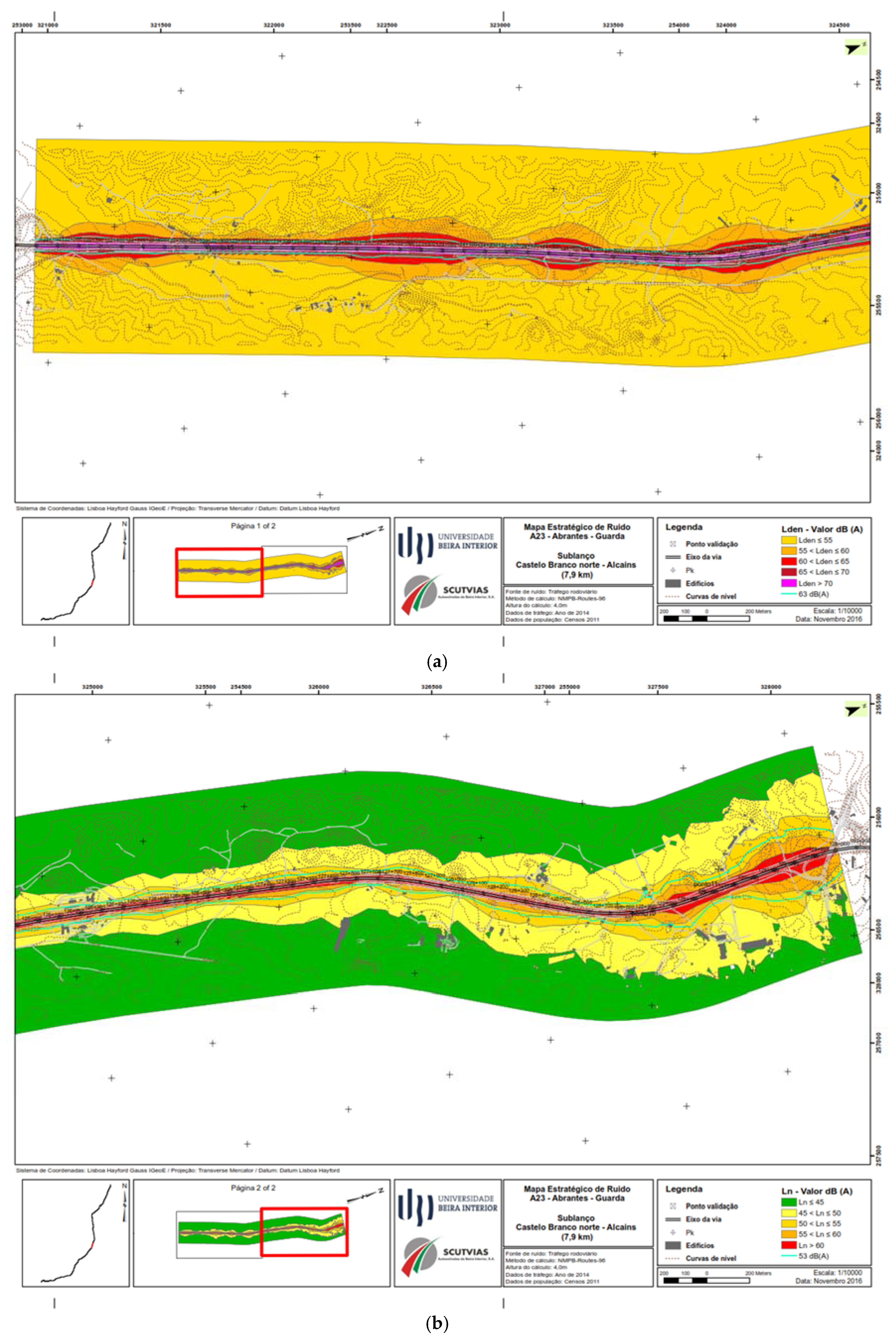
3. Results and Discussion

The values measured in situ and the simulated values of noise level, expressed in dB(A), to the harmonized noise indicators and in accordance with the standard NP ISO 1996-1 of 2003 [6], show a low difference (in modulus) between the simulated sound level and the measured sound level, with a minor or approximate difference of 2 dB(A) at most points (Table 2).
Figure 1a shows an example of a map of noise for the section between Castelo Branco Norte and Alcains to L R d e n , and Figure 1b shows an example of noise map for the L R n indicator.
Additional information was compiled on population and soil uses in the study area, having been marked the soil type uses for non-sensitive and sensitive buildings, these being the housing or mixed buildings. The data on population in Portugal was compiled by the INE (National Statistics Institute) [9], being the most up to date data relating to Census 2011. Thus, these data are available on a geographical basis of referencing information (BGRI), which develops according to a hierarchical polygonal structure whose basic unit is the statistical Subsection representation.
The results indicate that it is necessary to intervene in all the places identified with human occupation subjected to noise levels higher than would be expected. The solution to be implemented should include the installation of acoustic absorbent barriers, with a height of 2.5 m and a length of 200 m. In Table 3 is presented the population exposed to noise, the number of buildings exposed to noise, and the area in km2.

4. Conclusions

The noise model used in this study can displaying relevant and accurate information about the spatial distribution of noise around the infrastructures and can be used for supporting the municipal decision makers in the elaboration of their noise maps or for proving several activities which generates noise. The template for creating the simulation was validated by comparing the existing reality based on the prior knowledge of the infrastructure, and on the observation of the model through three-dimensional views. The results in terms of noise levels were also validated through the comparison between measured values and calculated values in points and receivers.
A crucial aspect to ensuring the efficiency and sustainability of the noise control measures that may be implemented in the future at these highways, is to planning territory interventions and occupation at the municipal level, to avoid the emergence of new residential zones with high acoustic sensitivity.

Author Contributions

This work was developed by authors in the scope of the environmental monitoring of the A23 motorway.

Acknowledgments

The authors thank the Research and Development Unit GeoBioTec for funding this work through research project ref: UID/GEO/04035/2013.

Conflicts of Interest

The authors declare no conflict of interest.

References

  1. Kinsler, L.E.; Frey, A.R.; Coppens, A.B.; Sanders, J.V. Fundamentals of Acoustics, 4th ed.; Kinsler, L.E., Frey, A.R., Coppens, A.B., Sanders, J.V., Eds.; Wiley-VCH: Hoboken, NJ, USA, 1999; 560p, ISBN 0-471-84789-5. [Google Scholar]
  2. Banfi, S.; et al. External Cost of Transport: Accident, Environmental and Congestion Costs in Western Europe; INFRAS and IWW: Zürich/Karlsruhe, Switzerland and Germany, 2000. [Google Scholar]
  3. Schreyer, C.; Schneider, C.; Maibach, M.; Rothengatter, W.; Doll, C.; Schmedding, D. External Cost of Transport; 2004; Update study. [Google Scholar]
  4. WHO. Preamble to the Constitution of the World Health Organization as adopted by the International Health Conference, New York, 19–22 June 1946; WHO: Geneva, Switzerland, 1946; 2p.
  5. European Parliament and Council of the European Union. Assessment and Management of Environmental Noise (EU Directive); No. L189; Offical Journal of the European Communities: Brussels, Belgium, 2002; pp. 12–25. [Google Scholar]
  6. ISO. ISO 1996-1: Acoustics—Description, Measurement and Assessment of Environmental Noise—Part 1: Basic Quantities and Assessment Procedures; ISO: Geneva, Switzerland, 2003. [Google Scholar]
  7. CERTU, CSTB, LCPC, and SETRA. Bruit des Infrastructures Routières: Méthode de Calcul incluant les Effets Météorologiques, Version Expérimentale NMPB-Routes-96; J. Off. du 10 mai 1995, Artic. 6o French Stand. ‘XPS 31-133’; Cetur-Centre Etud Transp: Alairac, France, 1997; p. 98. [Google Scholar]
  8. Dutilleux, G.; Defrance, J.; Ecotière, D.; Gauvreau, B.; Bérengier, M.; Besnard, F.; Duc, E.L. NMPB-routes-2008: The revision of the french method for road traffic noise prediction. Acta Acust. United Acust. 2010, 96, 452–462. [Google Scholar] [CrossRef]
  9. Instituto Nacional de Estatística. Censos 2011 Resultados Definitivos—Portugal; Instituto Nacional de Estatística: Lisboa, Portugal, 2011. [Google Scholar]
Figure 1. (a) Example of noise levels map to the L R d e n indicator; (b) noise levels map to the L R n .
Proceedings 02 01306 g001
Table 1. Traffic values of vehicle used for the calculation of noise maps of Subsection in study.
Average Daily Traffic 2016VehicleLightHeavyLightHeavyLightHeavyLightHeavy
Dist. (km)07:00–20:0020:00–23:0023:00–07:00Total
Cast. B. Norte–Alcains7.97249610931786651238845811
Table 2. Comparison between measured and simulated values.
P.MeasuredSimulatedDifference (in Modulus)
L R d e n L R n L R d e n L R n L R d e n L R n
161.8454.862.0853.680.241.12
254.0746.456.548.42.462.0
361.5552.663.455.41.92.8
470.6559.569.461.01.31.5
568.2659.168.059.70.30.6
L R d e n : day-evening-night noise indicator; L R n : night noise indicator.
Table 3. Estimated number of people and buildings, and the exhibition area (km2) for L R d e n   and   L R n .
LRdenLRn
RangePeopleBuildingsExhibition AreaRangePeopleBuildingsExhibition Area
55 < LRden ≤ 60235675.9445 < LRn ≤ 50264885.13
60 < LRden ≤ 6570200.9450 < LRn ≤ 55105341.49
65 < LRden ≤ 70410.4755 < LRn ≤ 60830.60
70 < LRden ≤ 75000.2260 < LRn ≤ 65000.27
LRden > 75000.2565 < LRn ≤ 70000.31
LRn > 70000
Publisher’s Note: MDPI stays neutral with regard to jurisdictional claims in published maps and institutional affiliations.

