1. Introduction
The hydrologic zone between soil surface and groundwater table, plays an important role in the recharging of groundwater. Unsaturated zone constitutes a protecting filter for the groundwater by transporting pollutants such as pesticides and fertilizers that might come from the ground surface and contaminating the groundwater. In the unsaturated zone many hydrologic, chemical and biological processes take place simultaneously within different soil horizons. Hence, the soil water and solute transport in the unsaturated zone are components of a complex process.
In order to describe the downward movement of water within the unsaturated zone, the use of naturally occurring or human induced environmental tracers is possible. Different types of environmental tracers can provide different types of information. Natural tracers in hydrological processes research have been useful in determining water pathways, evolution, and age [
1,
2,
3].
Environmental tracers such as chloride (Cl
−) are produced naturally in the Earth’s atmosphere and are used to estimate recharge rates [
4,
5]. Chloride is a widely used environmental tracer in unsaturated zone hydrologic studies. The movement of chloride within the soil is determined by water fluxes [
6] and, especially, the relationship between precipitation and evapotranspiration. Chloride concentrations in a soil profile are determined by pore water.
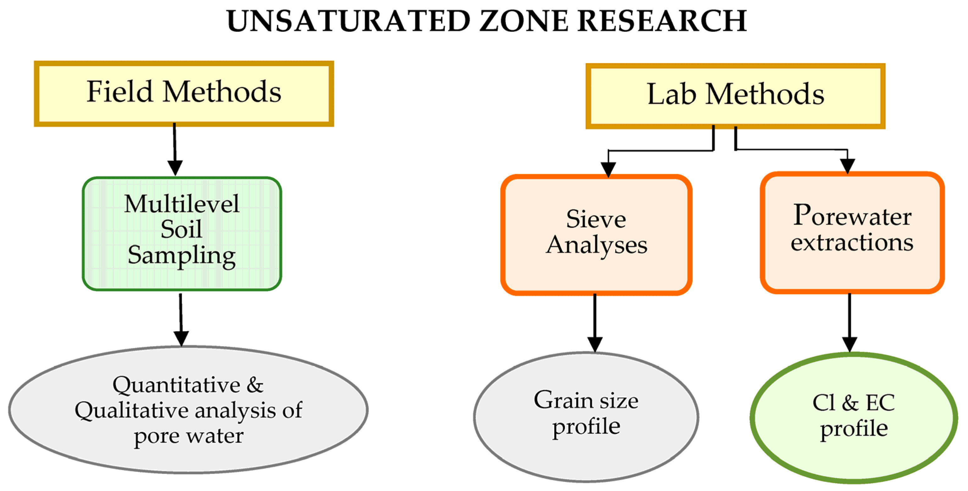
There are several different water extraction methods currently used to extract water from soil such as vacuum distillation, azeotropic distillation, cryogenic microdistillation, centrifugation, squeezing, leaching and equilibration. This study refers to the development of a methodological framework (
Figure 1) for investigating the hydrologic processes within the unsaturated zone through a series of field and lab technologies that target at: (i) multi-level undisturbed soil sampling using portable direct-push vibro-coring technologies, (ii) application of porewater extraction techniques for chemical analyses of soil water, and (iii) installation of multi-level continuous pore-water monitoring system.
2. Site Description
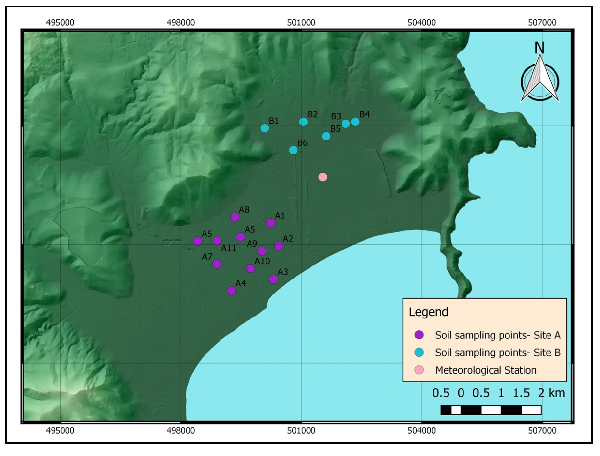
The study site is located in Marathon plain, in the NE of Attica peninsula, Greece (
Figure 2). The site covers an area of 40 km
2 and consists of unconsolidated sedimentary deposits. The Marathon plain includes a typical hydrogeological system with an upper unconsolidated formation by alluvial deposits among other aquifer formations. The region has a typical semi-dry Mediterranean climate with wet winters and dry summers. There are many drought periods with relatively low rainfall and high temperatures. The mean annual rainfall from 1987 to 2002 at Marathon plain was estimated at app. 500 mm and the average annual temperature was 17.1 °C. According to hydrogeological and hydrochemical studies the coastal plain of the basin is influenced by seawater intrusion because of the water demands for agricultural activities are satisfied by the exploitation of groundwater through numerous groundwater wells.
3. Materials and Methods
Samples of unsaturated zone material were taken from the surface to various depths using a portable direct-push vibro-coring set that offered high resolution subsurface investigation and undisturbed soil sampling. Direct push is applicable in unconsolidated sediments, ranging from clay to sand to gravel layers. Hence, a casing is vibrated to penetrate the subsurface using a variable frequency vibrator which is clamped to the outside of a sample liner. When the required depth is reached, the casing with the sampling liner is withdrawn and the liner can be capped for further analysis. No drilling fluids are necessary that would alter water content and water chemistry. Undisturbed soil cores of 50 mm diameter were sampled at standard intervals of 0.5 m from the ground surface down to a depth of 3.0 m. The depth of coring was dependent on the efficiency of drilling equipment to core the material encountered. Samples were obtained in April 2017 from 17 different locations within alluvial deposits. At each of the site approximately 500–700 g of sediment were removed and placed in polyethylene bags. Then, the samples were transported to the laboratory for sieve analysis and determination of electrical conductivity and chloride concentrations.
In order to classify different sediments, grain-size analyses were conducted. This method determines the percentage of different grain sizes contained within each horizon of the soil profile. The distribution of particle size larger than 75 micrometers (retained on the No. 200 sieve) was determined by sieving [
7,
8]. Sieving is considered the most widely used method of particle size analysis due the relative simplicity of the technique. The distribution of particle sizes smaller than 75 micrometers was determined by a sedimentation process using a hydrometer [
7,
8]. This method is based on Stoke’s law governing the rate of sedimentation of particles suspended in water.
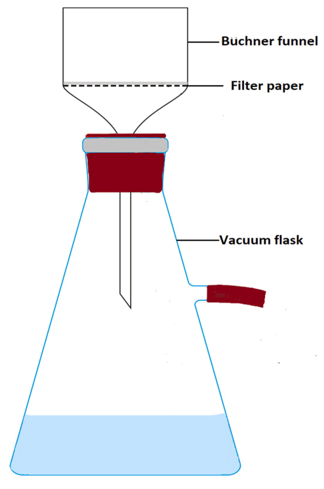
The usual method to quantify chloride concentration and electrical conductivity in soil samples is the saturated paste method because it comes closer to the water content of the soil under field conditions. Water was extracted from the saturated paste samples by vacuum filtration, a technique used to separate solids from liquids. This method requires a Büchner funnel, Büchner flask and a water aspirator assembly (
Figure 3). On top of the funnel, a filter paper with the appropriate diameter is placed and wetted with a small amount of the solvent to be used in the filtration. The saturated paste to be filtered is poured onto the filter paper and the vacuum should rapidly pull the liquid through the funnel. The extracted water was collected in bottles and tightly sealed to prevent evaporation. The saturated paste was prepared according to methods for measuring soluble salts by US Salinity Laboratory Staff [
9].
The chloride concentration of the extract was measured by a simple titration in accordance with titrate AgNO3 2256 N of HACH. The chloride concentration in extracted water was expressed as meq/L. In addition, to quantify the soluble salts concentration in soils samples the electrical conductivity (EC) of the soil water extract was measured with an electrical conductivity meter. The unit most commonly used for EC in soil-water extracts is mmhos cm−1.
4. Results
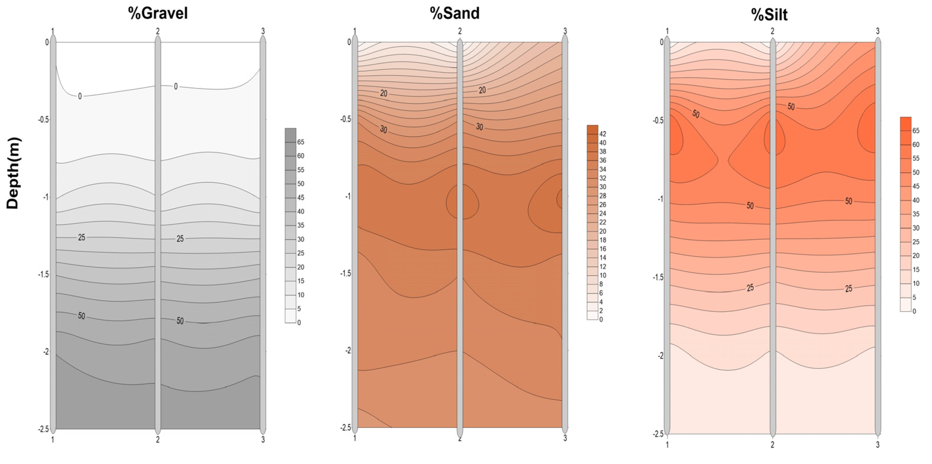
The grain size analyses carried out in three adjacent boreholes for two representative locations and are presented in
Figure 4 and
Figure 5. The results in Site A showed that soils in the upper 1 m consist of silt (50–65%) and sand (32–38%). The dominant sediments (down to 2.5 m depth) are gravels (60%) while clay is less than 2 percent. In Site B, soils consist mainly of silt (40–70%) and sand (20–40%).
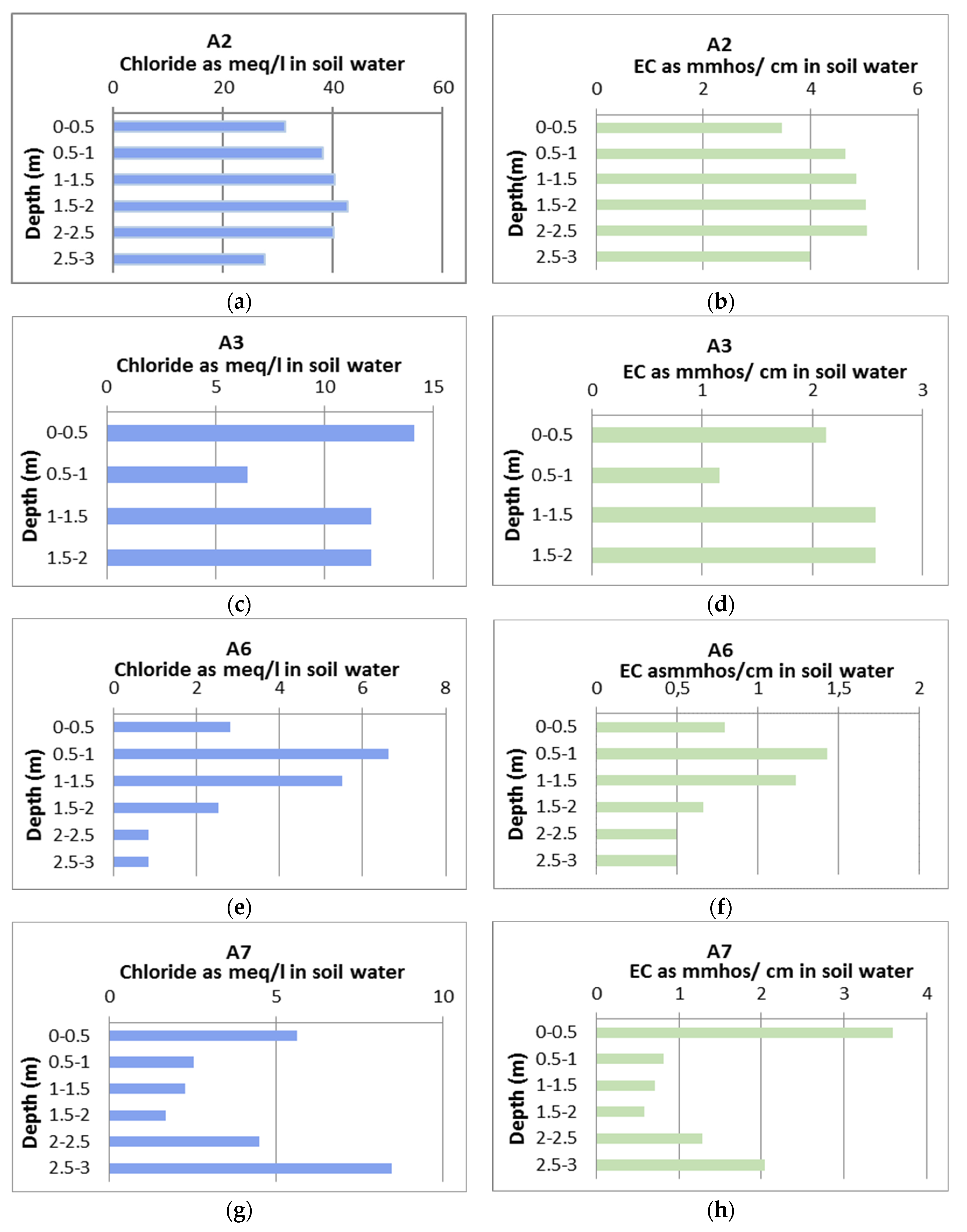
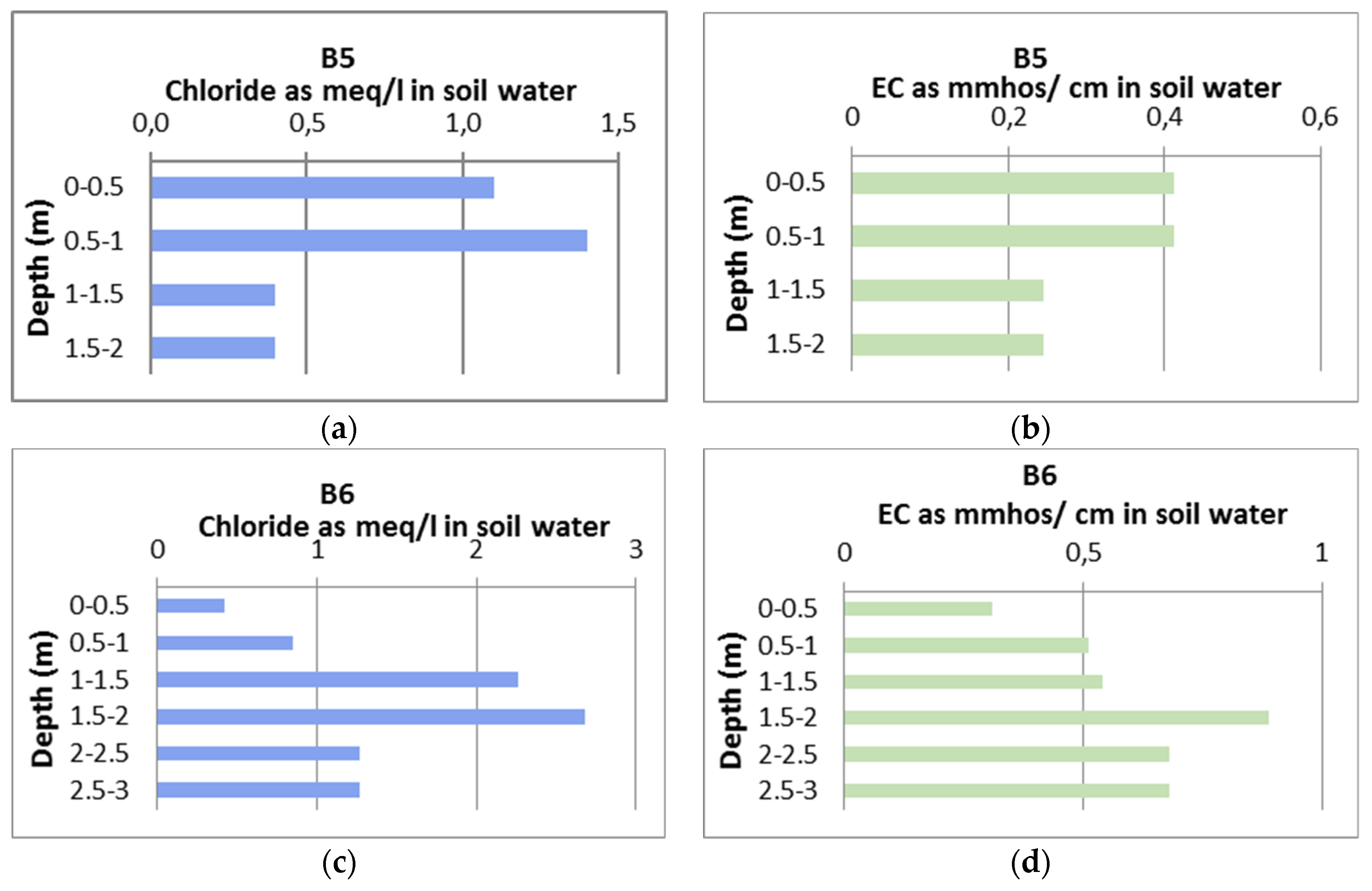
The chloride concentration and electrical conductivity values were plotted versus depth in
Figure 6,
Figure 7 and
Figure 8. The analyses of chloride show a strong variability of solute concentrations. Vertical distribution of chloride concentrations and EC varies significantly within the unsaturated columns of the two selected experimental plots.
Chloride concentration in Site A fluctuates generally within a range of 0.3 to 14.1 meq/L. The highest chloride concentration values (up to 42 meq/L) were recorded in sample A2. The significant increase in values in sample A2 is due to the existence of ground water table at 3.5 m depths. In contrast, the chloride concentration values in the Site B presented significant lower rates up to 4.1 meq/L and increased with depth. This agrees with a model described by Gardner (1967) which predict that under steady-state conditions, where the soil receives chloride in rainfall each year and soil water moves by piston flow, the concentration of chloride in soil water should increase to the bottom of the root zone and then remain constant [
10]. The presence of chloride peak is widespread in semi-arid areas, which has been shown in numerous localities world-wide [
11,
12,
13,
14].
High chloride concentration values in Site A, indicate low recharge rates because chloride accumulates in the subsurface as a result of evapotranspiration whereas low chloride concentrations indicate high recharge rates because chloride is flushed through the subsurface. These results indicate that recharge through the soil matrix seems to be controlled by soil structure. In addition, human induced practices, such as irrigation and fertilization, contribute significantly to chlorine deposition. Irrigating amounts too low to leach salts, or with water high in salts, allows salts to accumulate in the root zone, increasing the electrical conductivity. The electrical conductivity (EC) values ranged from 0.308 to 10.7 mmhos/cm. According to Dahnke and Whitney (1988), the soil samples in Site A are considered moderately saline (up to 0.5 m), slightly saline (0.5–1 m), non-saline (1–2.5 m) and the soil samples in Site B as non-saline (0–3 m) [
15].
5. Conclusions
Preliminary results from this study have proved that chloride concentration values for Site A, are higher than the concentration values in Site B, fact that is attributed to the higher percentage of silt and clay in the soil column of the unsaturated zone, that is believed to be responsible for reduced recharge rates in parts of Marathon plain. The low recharge rates and the large water-holding capacity of the fine textured soil have led to higher chloride concentrations within the measured soil profile. Due to the inherent silt and clay content, the soils in the area present with low vertical hydraulic conductivity values and therefore significantly higher chloride concentration values. Anthropogenic activities such as extensive application of fertilizers as well as intensive irrigation, also influenced the amounts of chloride deposited to the soil.
This research is part of a methodological framework that is under formation in order to develop a technically sound toolbox for unsaturated zone measurements. In principle, the water trapped in the unsaturated zone represents a historic record of infiltration events potentially enabling a quantification of present and past groundwater recharge. Therefore, we apply a combination of different experimental techniques that are targeted to retrieve the information contained in the unsaturated zone.




_S._Voudouris.png)
