Multirange Data in Cultural Heritage: Technologies, Formats and Visualization †
Abstract
:1. Introduction. Connections between Open-Air Rock Art and Landscape Topography
2. Objectives and Methodology
- A.
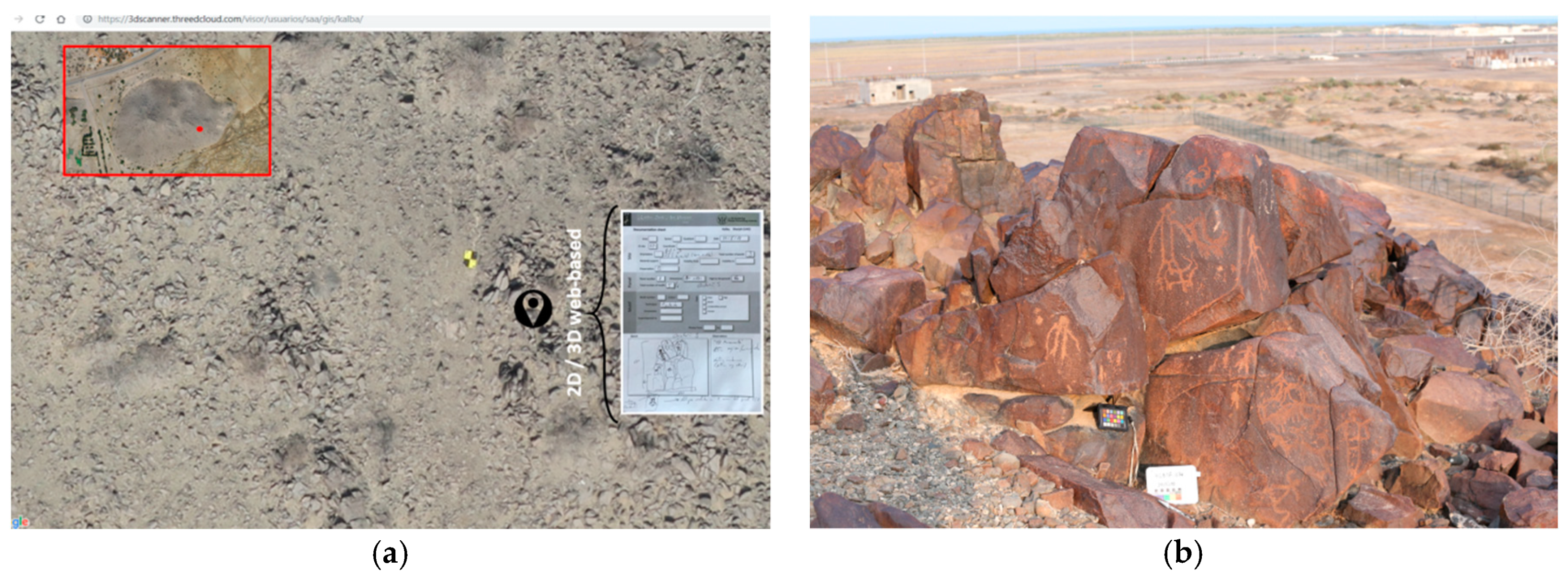
- Develop a multi-scalar documentation (Figure 2) in order to understand each rock art panel, the relationship among them as well as their logical geospatial location within the archaeological context. One of the three-dimensional digitalisation goals is to optimise time recording data and improve the results of both metric and graphic data. Credible data for testing and analysing is therefore obtained, while there is also a significant increase in the data obtained when recording. In order to develop the archaeological documentation for this site, the following Geomatic techniques have been used in all three completed campaigns:
- -
- -
- Aerial photogrammetry with a fixed-wing drone (2016). We have used an eBee drone by senseFly, aiming to generate an orthophoto with a resolution (GSD) of 2-centimetre-pixel of the entire archaeological site, approximately 70 hectares (Figure 2a). This technique allows of a better spatial resolution to locate the different rock art panels.
- -
- Close range photogrammetry techniques (2018). In 2018, an intensive archaeological survey was conducted in the entire archaeological site in order to document each rock engraving with close range photogrammetric techniques and a database. The results were the finding of 149 block stones with more than 370 rock art engravings.
- -
- GNSS RTK – PPK (2015, 2016, 2018). All surveys were georeferenced with a GNSS RTK Leica GRX1230 by means of Post-Processed Kinematic techniques (PPK).
- B.
- To launch a database that is interrelated and integrated into web pages in order to obtain a more detailed analysis of rock engravings. We have used the epicollect 5 mobile & web application for data collection in field activities (2018).
- C.
- Create and develop a web platform called threeDcloud [4] for visualising three-dimensional models and high-resolution images, allowing real-time interaction of the information. This web platform is based on potree, a free open-source WebGL to manage large point clouds [5], an open-source JavaScript library to adapt the orthophoto generated (leaflet), and a de-correlation view to analyse the 3D mesh of each Rock Art panel (three.js, DStretch).
3. Results
- -
- A general 3D point cloud of the hill, as well as digital models for each engraved block. This is meant to visualize and render large point clouds based on WebGL, a standard for rendering 3D graphics from any browser that supports it. It is not only used as a viewer, but also has certain tools for processing and using point cloud, such as profiling, area, volume, distance and height measurements, elevations, classification of point clouds and layers division.
- -
- Web mapping GIS with the integration of the orthophoto and each of the blocks documented in different layer types. This enables analysing the different styles and morphologies of the rock art stone blocks throughout the entire recorded archaeological site (Figure 2a).
- -
- 3D Mesh with the possibility of digital enhancement with the de-correlation view based on DStretch (Figure 1b). This is clearly an improvement in the view over some representations.
- -
- 360-degree spherical views from different points of the hill, in order to improve the spatial understanding of the archaeological site from an immersive perspective (Figure 2b).
4. Conclusions
Acknowledgments
References
- Ziolkowski, M.C.; Hassan, S.A.M. Three petroglyphs from the Emirate of Fujairah, United Arab Emirates. Proc. Semin. Arab. Stud. 2000, 30, 257–265. [Google Scholar]
- Otero, X.; Farjas, M.; Santos, M. La historia en el paisaje: diferentes lugares y análogas representaciones. Análisis e interpretación con las nuevas tecnologías de modelización virtual. In Proceedings of the 8th International Congress on Archaeology, Computer Graphics, Cultural Heritage and Innovation, ARQUEOLÓGICA 2.0; Universitat Politècnica de València: Valencia, Spain, 2016; pp. 321–323. [Google Scholar]
- Otero, X.; Farjas, M.; Santos, M.; Angás, J. Diferentes paisajes y análogas representaciones. In terpretación arqueológica con tecnologías de ingeniería inversa. In Primer Congreso en Ingeniería Geomática; Universitat Politècnica de València: Valencia, Spain, 2017; pp. 8–14. [Google Scholar]
- ThreeDcloud. Available online: http://www.threedcloud.com/ (accessed on 2 May 2019).
- Potree. Available online: http://potree.org/ (accessed on 2 May 2019).
- Boutsi, A.-M.; Ioannidis, C.; Soile, S. Interactive online visualization of complex 3D geometries. Int. Arch. Photogramm. Remote Sens. Spat. Inf. Sci. XLII-2/W9 2019, 173–180. [Google Scholar] [CrossRef]


Disclaimer/Publisher’s Note: The statements, opinions and data contained in all publications are solely those of the individual author(s) and contributor(s) and not of MDPI and/or the editor(s). MDPI and/or the editor(s) disclaim responsibility for any injury to people or property resulting from any ideas, methods, instructions or products referred to in the content. |
© 2019 by the authors. Licensee MDPI, Basel, Switzerland. This article is an open access article distributed under the terms and conditions of the Creative Commons Attribution (CC BY) license (https://creativecommons.org/licenses/by/4.0/).
Share and Cite
Angás, J.; Farjas, M.; Bea, M. Multirange Data in Cultural Heritage: Technologies, Formats and Visualization. Proceedings 2019, 19, 16. https://doi.org/10.3390/proceedings2019019016
Angás J, Farjas M, Bea M. Multirange Data in Cultural Heritage: Technologies, Formats and Visualization. Proceedings. 2019; 19(1):16. https://doi.org/10.3390/proceedings2019019016
Chicago/Turabian StyleAngás, Jorge, Mercedes Farjas, and Manuel Bea. 2019. "Multirange Data in Cultural Heritage: Technologies, Formats and Visualization" Proceedings 19, no. 1: 16. https://doi.org/10.3390/proceedings2019019016
APA StyleAngás, J., Farjas, M., & Bea, M. (2019). Multirange Data in Cultural Heritage: Technologies, Formats and Visualization. Proceedings, 19(1), 16. https://doi.org/10.3390/proceedings2019019016


