Change Detection of Lakes in Pokhara, Nepal Using Landsat Data †


Abstract
:1. Introduction
2. Experiments
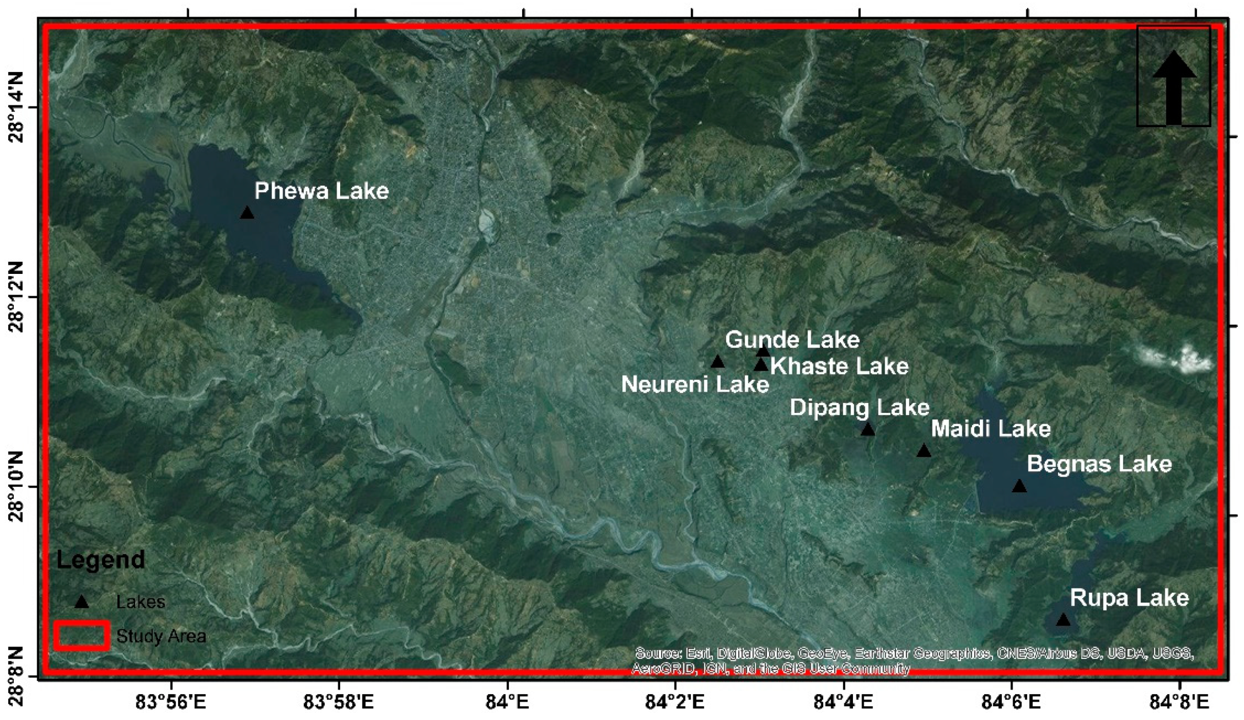
2.1. Test Site
2.2. Data
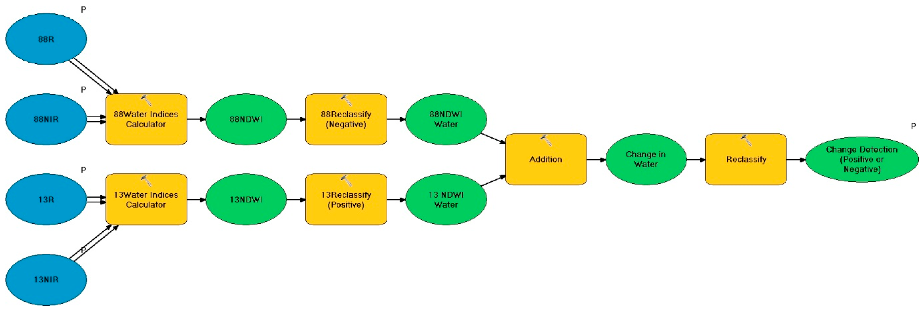
2.3. Method
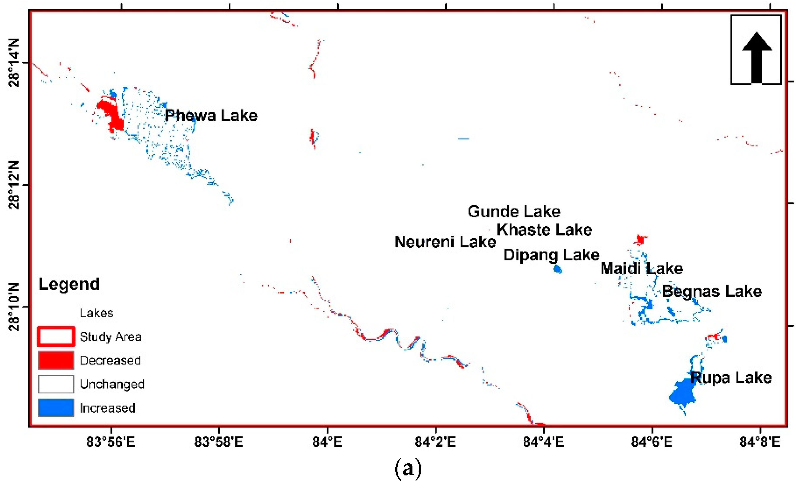
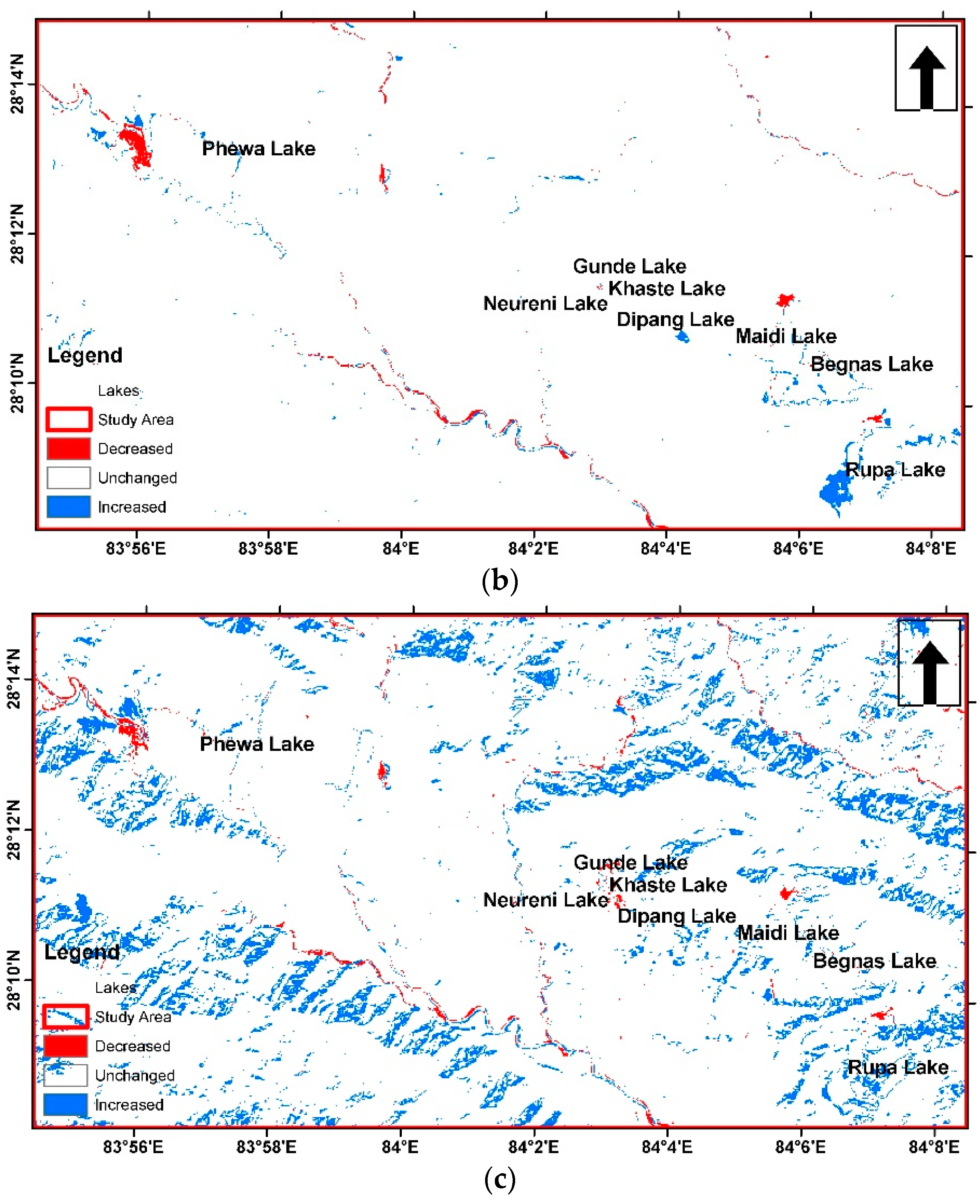
3. Results and Discussion
4. Conclusions
Author Contributions
Conflicts of Interest
References
- Li, L.; Xia, H.; Li, Z.; Zhang, Z. Temporal-Spatial Evolution Analysis of Lake Size-Distribution in the Middle and Lower Yangtze River Basin using Landsat Imagery Data. Remote Sens. 2015, 7, 10364–10384. [Google Scholar] [CrossRef]
- Jiang, H.; Feng, M.; Zhu, Y.; Lu, N.; Huang, J.; Xiao, T. An Automated Method for Extracting Rivers and Lakes from Landsat Imagery. Remote Sens. 2014, 6, 5067–5089. [Google Scholar] [CrossRef]
- Rokni, K.; Ahmad, A.; Selamat, A.; Hazini, S. Water Feature Extraction and Change Detection Using Multitemporal Landsat Imagery. Remote Sens. 2014, 6, 4173–4189. [Google Scholar] [CrossRef]
- Acharya, T.D.; Lee, D.H.; Yang, I.T.; Lee, J.K. Identification of Water Bodies in a Landsat 8 OLI Image Using a J48 Decision Tree. Sensors 2016, 16, 1075. [Google Scholar] [CrossRef] [PubMed]
- Frazier, P.S.; Page, K.J. Water Body Detection and Delineation with Landsat TM Data. Photogramm. Eng. Remote Sens. 2000, 66, 1461–1468. [Google Scholar]
- Tulbure, M.G.; Broich, M.; Stehman, S.V.; Kommareddy, A. Surface Water Extent Dynamics from Three Decades of Seasonally Continuous Landsat Time Series at Subcontinental Scale in a Semi-Arid Region. Remote Sens. Environ. 2016, 178, 142–157. [Google Scholar] [CrossRef]
- Sivanpillai, R.; Miller, S.N. Improvements in Mapping Water Bodies Using ASTER Data. Ecol. Inform. 2010, 5, 73–78. [Google Scholar] [CrossRef]
- McIver, D.K.; Friedl, M.A. Using Prior Probabilities in Decision-Tree Classification of Remotely Sensed Data. Remote Sens. Environ. 2002, 81, 253–261. [Google Scholar] [CrossRef]
- Sethre, P.R.; Rundquist, B.C.; Todhunter, P.E. Remote Detection of Prairie Pothole Ponds in the Devils Lake Basin, North Dakota. GISci. Remote Sens. 2005, 42, 277–296. [Google Scholar] [CrossRef]
- Du, Z.; Linghu, B.; Ling, F.; Li, W.; Tian, W.; Wang, H.; Gui, Y.; Sun, B.; Zhang, X. Estimating Surface Water Area Changes Using Time-Series Landsat Data in the Qingjiang River Basin, China. J. Appl. Remote Sens. 2012, 6, 063609. [Google Scholar] [CrossRef]
- Feyisa, G.L.; Meilby, H.; Fensholt, R.; Proud, S.R. Automated Water Extraction Index: A New Technique for Surface Water Mapping using Landsat Imagery. Remote Sens. Environ. 2014, 140, 23–35. [Google Scholar] [CrossRef]
- Ji, L.; Zhang, L.; Wylie, B. Analysis of Dynamic Thresholds for the Normalized Difference Water Index. Photogramm. Eng. Remote Sens. 2009, 75, 1307–1317. [Google Scholar] [CrossRef]
- Xu, H. Modification of Normalised Difference Water Index (NDWI) to Enhance Open Water Features in Remotely Sensed Imagery. Int. J. Remote Sens. 2006, 27, 3025–3033. [Google Scholar] [CrossRef]
- Rogers, A.S.; Kearney, M.S. Reducing Signature Variability in Unmixing Coastal Marsh Thematic Mapper Scenes Using Spectral Indices. Int. J. Remote Sens. 2004, 25, 2317–2335. [Google Scholar] [CrossRef]
- McFeeters, S.K. The use of the Normalized Difference Water Index (NDWI) in the Delineation of Open Water Features. Int. J. Remote Sens. 1996, 17, 1425–1432. [Google Scholar] [CrossRef]
- Tulbure, M.G.; Broich, M. Spatiotemporal Dynamic of Surface Water Bodies using Landsat Time-Series Data from 1999 to 2011. ISPRS J. Photogramm. Remote Sens. 2013, 79, 44–52. [Google Scholar] [CrossRef]
- Malahlela, O.E. Inland Waterbody Mapping: Towards Improving Discrimination and Extraction of Inland Surface Water Features. Int. J. Remote Sens. 2016, 37, 4574–4589. [Google Scholar] [CrossRef]
- Xie, H.; Luo, X.; Xu, X.; Pan, H.; Tong, X. Evaluation of Landsat 8 OLI Imagery for Unsupervised Inland Water Extraction. Int. J. Remote Sens. 2016, 37, 1826–1844. [Google Scholar] [CrossRef]
- Rouse, J., Jr.; Haas, R.; Schell, J.; Deering, D. Monitoring Vegetation Systems in the Great Plains with ERTS. NASA Spec. Publ. 1974, 351, 309–317. [Google Scholar]

| Satellite | Sensor | Path/Row | Year | Resolution | Wavelength |
|---|---|---|---|---|---|
| Landsat 5 | TM | 142/40 | 1988 | 30 | Band 1: 0.45–0.52 |
| Band 2: 0.52–0.60 | |||||
| Band 3: 0.63–0.69 | |||||
| Band 4: 0.76–0.90 | |||||
| Band 5: 1.55–1.75 | |||||
| Band 7: 2.08–2.35 | |||||
| Landsat 8 | OLI | 2013 | Band 1: 0.435–0.451 | ||
| Band 2: 0.452–0.512 | |||||
| Band 3: 0.533–0.590 | |||||
| Band 4: 0.636–0.673 | |||||
| Band 5: 0.851–0.879 | |||||
| Band 6: 1.566–1.651 | |||||
| Band 7: 2.107–2.294 | |||||
| Band 9: 1.363–1.384 |
| S. No. | Spectral Indices | Formula | Reference |
|---|---|---|---|
| 1 | Normalized Difference Vegetation Index (NDVI) | (NIR − Red)/(NIR + Red) | [19] |
| 2 | Normalized Difference Water Index (NDWI) | (Green − NIR)/(Green + NIR) | [15] |
| 3 | Modified Normalized Difference Water Index (MNDWI) | (Green − SWIR)/(Green + SWIR) | [13] |
Publisher’s Note: MDPI stays neutral with regard to jurisdictional claims in published maps and institutional affiliations. |
© 2016 by the authors. Licensee MDPI, Basel, Switzerland. This article is an open access article distributed under the terms and conditions of the Creative Commons Attribution (CC BY) license (https://creativecommons.org/licenses/by/4.0/).
Share and Cite
Acharya, T.D.; Yang, I.T.; Subedi, A.; Lee, D.H. Change Detection of Lakes in Pokhara, Nepal Using Landsat Data. Proceedings 2017, 1, 17. https://doi.org/10.3390/ecsa-3-E005
Acharya TD, Yang IT, Subedi A, Lee DH. Change Detection of Lakes in Pokhara, Nepal Using Landsat Data. Proceedings. 2017; 1(2):17. https://doi.org/10.3390/ecsa-3-E005
Chicago/Turabian StyleAcharya, Tri Dev, In Tae Yang, Anoj Subedi, and Dong Ha Lee. 2017. "Change Detection of Lakes in Pokhara, Nepal Using Landsat Data" Proceedings 1, no. 2: 17. https://doi.org/10.3390/ecsa-3-E005
APA StyleAcharya, T. D., Yang, I. T., Subedi, A., & Lee, D. H. (2017). Change Detection of Lakes in Pokhara, Nepal Using Landsat Data. Proceedings, 1(2), 17. https://doi.org/10.3390/ecsa-3-E005