
A Comprehensive Systematic Review of Machine Learning Applications in Assessing Land Use/Cover Dynamics and Their Impact on Land Surface Temperatures


Abstract
1. Introduction
1.1. Factors Affecting LST in Urbanized Cities
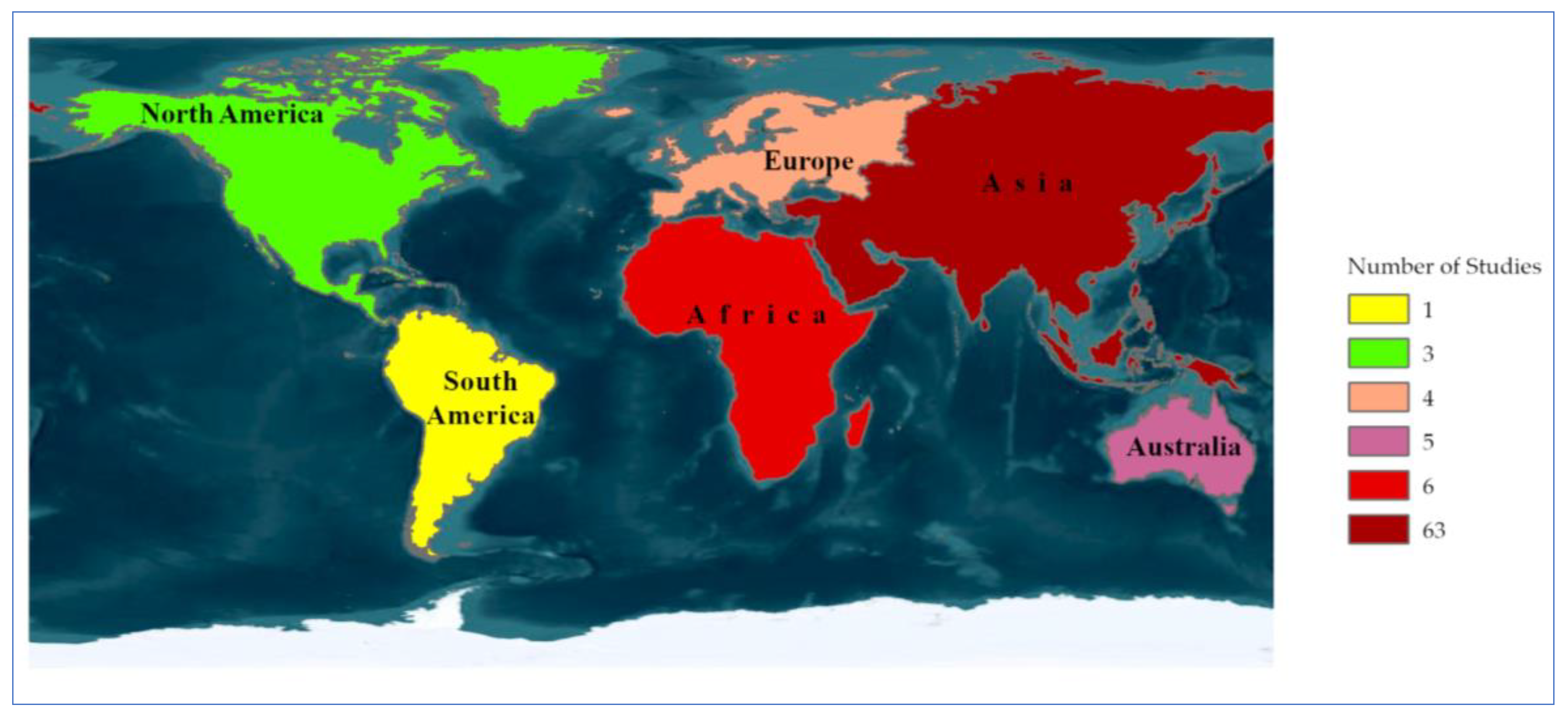
1.2. Exploring Worldwide Perspectives: Comprehensive Approaches and Case Analyses
2. Methodology
Screening Criteria
3. Results
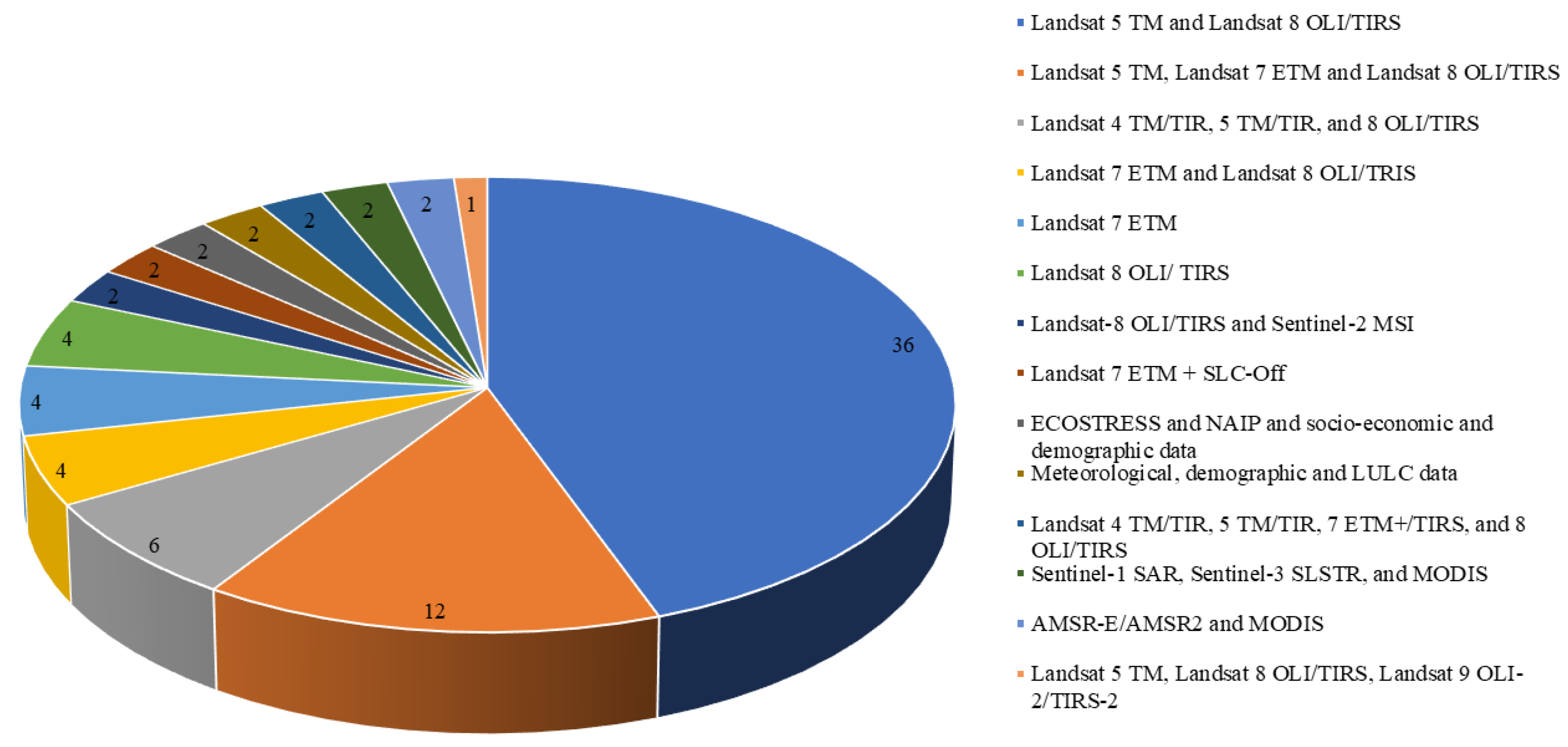
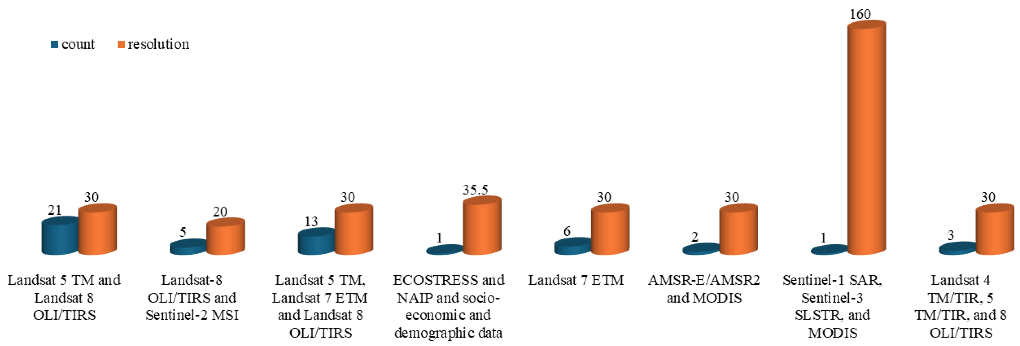
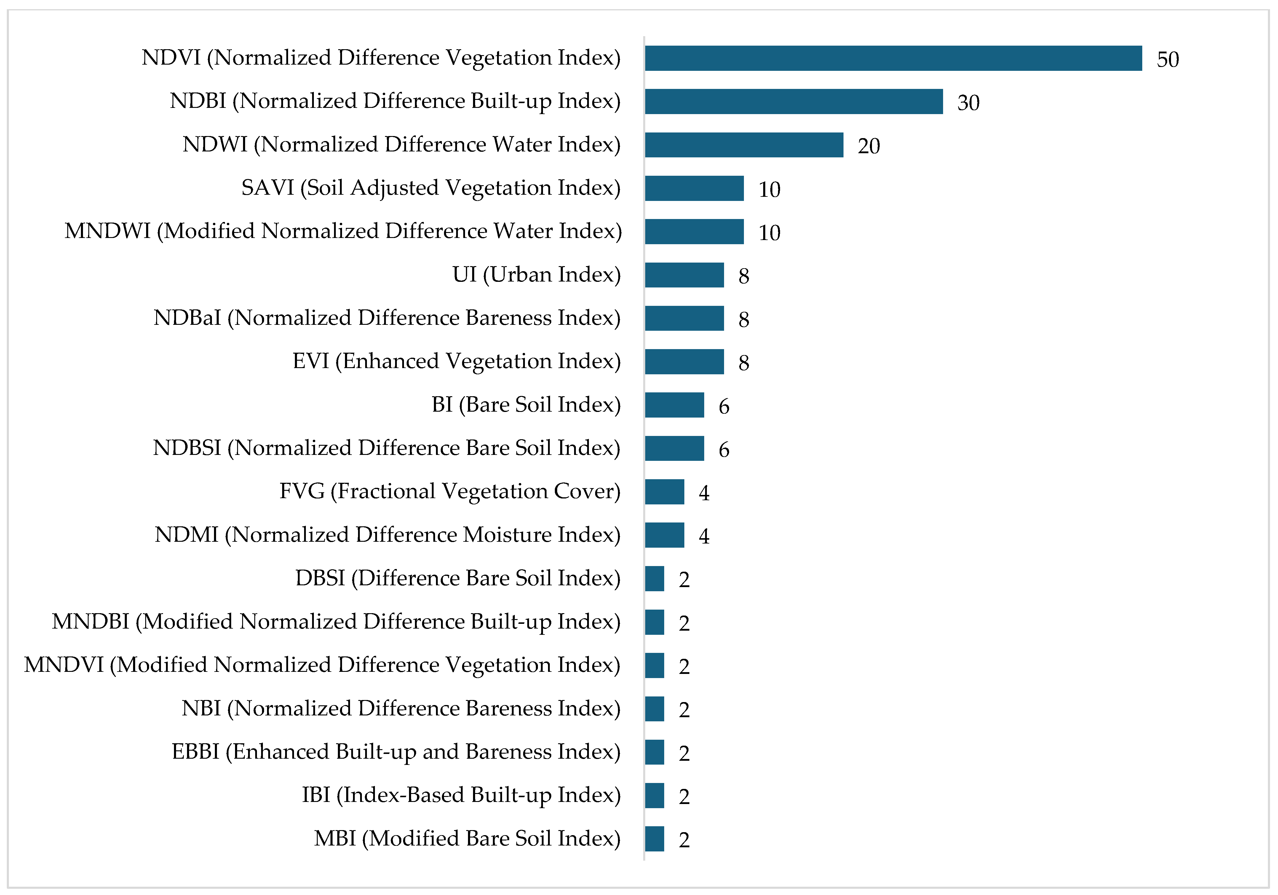
3.1. Approaches to Land Use and Land Cover Data Collection and Processing
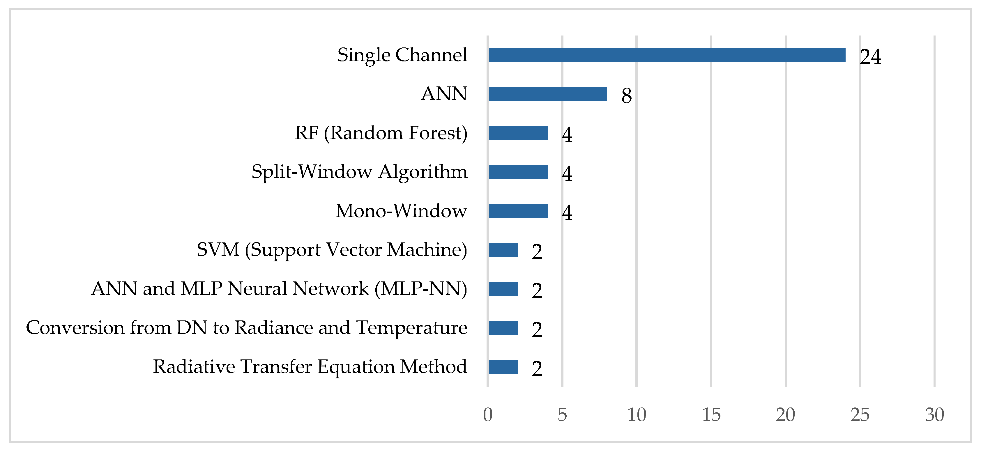
3.2. Techniques Used for Estimating LST
3.3. Overview of Machine Learning Approaches for LULC and LST Prediction
4. Discussions
4.1. Data Sources
4.2. Variable Selection and Accuracy Assesment
4.3. Machine Learning for Assessing Land Use Impacts on LSTs

| Technique | Quantitative Relationship | Location | Ref. |
|---|---|---|---|
| linear regression analysis | A strong negative correlation between LST and vegetation cover and strong positive correlation between socioeconomic disparities and spatial distribution of summer daytime and nighttime LST (Mean LST across Phoenix (28.86 °C) was lower than the urban core (29.14 °C). | Phoenix, AZ, USA | [29] |
| Pearson correlation coefficient | The UHI intensity was negatively related to the density of green space, aquatic area, NDVI, altitude, and sky view factor (p < 0.01), and the UHI intensity was positively related to the density of built-up areas, population density, and mean building height (p < 0.01). | Shenzhen, China | [80] |
| Pearson correlation | In 1995, a strong positive association was found between LST and NDBI and NDBSI, with a negative correlation to NDVI and NDWI. High temperature differences led to decreased water content and green cover, while excessive bear soil and buildup increased LST values. | Dhaka, Bangladesh | [136] |
| Pearson correlation coefficient | There is a strong negative correlation between LST and the NDVI each year with the mean LST increase of 0.19 °C. | Rajshahi, Bangladesh | [135] |
| Pearson correlation coefficient | Strong positive correlation between NDBI and LST (36.38% and 38.44% of the NDBI variability can be ascribed to LST during 2000, 2014, and 2022), a negative relationship between LST and NDVI (22.86% and 23.46% of the NDVI variability can be ascribed to LST during 2000, 2014, and 2022). | Kamrup, India | [134] |
| pixel-based correlation analysis | The study found a correlation between LST and NDVI, showing 2% to 35% variability in NDVI. The correlation between LST and NDBI was also low, showing 5% to 26% variability. | Irbid governorate, Jordan | [66] |
| NDBI index | The NDBI-LST relationship shows the significance of the built-up zone on the final surface temperature increase (LST). As the built-up area increases, the impervious layers rise in elevation, leading to higher LST. | Kuwait | [40] |
| Pearson correlation coefficient | Positive correlations between built-up areas and SUHII (0.82), and negative correlations between vegetation cover and SUHII (−0.73). | Bangkok, Thailand | [68] |
| Linear regression | LST represents strong and positive correlation with NDBI (29.36 °C in 1999, 29.69 °C in 2009, 39.52 °C in 2019) and strongly negative correlation with NDVI, NDWI, and NDBa. | Rajshahi, Bangeladesh | [135] |
| Pearson correlation coefficient | Strong negative correlation between NDVI and LST, with a correlation coefficient of −0.935. Dhaka’s core urban area experienced LST around 34 °C in 2000, increasing to over 35 °C as urbanization increased. Greener areas with more vegetation had lower LST. | Dhaka, Bangeladesh | [136] |
| NDBI index | From 1999 to 2019, urban areas increased from 20.45 km2 to 26.31 km2, while vegetation and water bodies decreased. Bare land area increased from 3.52 km2 to 12.48%, with the highest positive net changes for urban area and bare land. | Cumilla, Bangladesh | [125] |
| Pearson correlation | Strong negative correlation between LST and various indices in 2010 (0.93) and a strong negative relationship with the NDVI and NDWI (−0.95 in 2020). | Al Kut, Iraq | [37] |
| Linear analysis | Urban index (UI) was the most influential parameter contributing 30.16% to LST, followed by Normalized Difference Built-up Index (NDBI) at 27.5%, Normalized Difference Vegetation Index (NDVI) at 24.73%, and Normalized Difference Water Index (NDWI) at 18.04%. | Freetown, Sierra-Leon | [41] |
| Kapa Coefficient | The study revealed significant urbanization in Lahore, with built-up areas increasing by 359.8 km2 from 1994 to 2024, while vegetation decreased by 198.7 km2 and barren land by 158.5 km2. Water bodies continued to be relatively stable. Future projections for 2034 and 2044 indicate continued urban expansion at the expense of vegetation and barren land. The CA-Markov model achieved a high prediction accuracy with a Kappa coefficient of 0.92. | Lahore, Pakistan | [141] |
5. Conclusions
Author Contributions
Funding
Data Availability Statement
Conflicts of Interest
References
- Patel, S.; Indraganti, M.; Jawarneh, R.N. Land surface temperature responses to land use dynamics in urban areas of Doha, Qatar. Sustain. Cities Soc. 2024, 104, 105273. [Google Scholar] [CrossRef]
- Ullah, W.; Ahmad, K.; Ullah, S.; Tahir, A.A.; Javed, M.F.; Nazir, A.; Abbasi, A.M.; Aziz, M.; Mohamed, A. Analysis of the relationship among land surface temperature (LST), land use land cover (LULC), and normalized difference vegetation index (NDVI) with topographic elements in the lower Himalayan region. Heliyon 2023, 9, e13322. [Google Scholar] [CrossRef] [PubMed]
- Kim, M.; Kim, D.; Kim, G. Examining the Relationship between Land Use/Land Cover (LULC) and Land Surface Temperature (LST) Using Explainable Artificial Intelligence (XAI) Models: A Case Study of Seoul, South Korea. Int. J. Environ. Res. Public Health 2022, 19, 15926. [Google Scholar] [CrossRef] [PubMed]
- Kafy, A.-A.; Saha, M.; Faisal, A.-A.; Rahaman, Z.A.; Rahman, M.T.; Liu, D.; Fattah, M.A.; Al Rakib, A.; AlDousari, A.E.; Rahaman, S.N.; et al. Predicting the impacts of land use/land cover changes on seasonal urban thermal characteristics using machine learning algorithms. Build. Environ. 2022, 217, 109066. [Google Scholar] [CrossRef]
- Li, H.; Zhou, Y.; Li, X.; Meng, L.; Wang, X.; Wu, S.; Sodoudi, S. A new method to quantify surface urban heat island intensity. Sci. Total Environ. 2018, 624, 262–272. [Google Scholar] [CrossRef]
- Pal, S.; Sharma, P. A Review of Machine Learning Applications in Land Surface Modeling. Earth 2021, 2, 174–190. [Google Scholar] [CrossRef]
- Patel, S.; Indraganti, M.; Jawarneh, R.N. A Comprehensive Systematic Review: Impact of Land Use/Land Cover (LULC) on Land Surface Temperatures (LST) and Outdoor Thermal Comfort. Build. Environ. 2024, 249, 111130. [Google Scholar] [CrossRef]
- Pal, S.; Ziaul, S.K. Detection of land use and land cover change and land surface temperature in English Bazar urban centre. Egypt. J. Remote Sens. Space Sci. 2017, 20, 125–145. [Google Scholar] [CrossRef]
- Naserikia, M.; Hart, M.A.; Nazarian, N.; Bechtel, B.; Lipson, M.; Nice, K.A. Land surface and air temperature dynamics: The role of urban form and seasonality. Sci. Total Environ. 2023, 905, 167306. [Google Scholar] [CrossRef]
- Santhosh, L.G.; Shilpa, D.N. Assessment of LULC change dynamics and its relationship with LST and spectral indices in a rural area of Bengaluru district, Karnataka India. Remote Sens. Appl. Soc. Environ. 2023, 29, 100886. [Google Scholar] [CrossRef]
- Mokarram, M.; Taripanah, F.; Pham, T.M. Investigating the effect of surface urban heat island on the trend of temperature changes. Adv. Space Res. 2023, 72, 3150–3169. [Google Scholar] [CrossRef]
- Rostami, E.; Vahid, R.; Zarei, A.; Amani, M. Dynamic Analysis of Water Surface Extent and Climate Change Parameters in Zarivar Lake, Iran. Environ. Sci. Proc. 2024, 29, 71. [Google Scholar] [CrossRef]
- Wang, S.; Huang, X.; Liu, P.; Zhang, M.; Biljecki, F.; Hu, T.; Fu, X.; Liu, L.; Liu, X.; Wang, R.; et al. Mapping the landscape and roadmap of geospatial artificial intelligence (GeoAI) in quantitative human geography: An extensive systematic review. Int. J. Appl. Earth Obs. Geoinf. 2024, 128, 103734. [Google Scholar] [CrossRef]
- Vujovic, S.; Haddad, B.; Karaky, H.; Sebaibi, N.; Boutouil, M. Urban Heat Island: Causes, Consequences, and Mitigation Measures with Emphasis on Reflective and Permeable Pavements. CivilEng 2021, 2, 459–484. [Google Scholar] [CrossRef]
- Krishnan, V.; Firoz, C. Impact of land use and land cover change on the environmental quality of a region: A case of Ernakulam district in Kerala, India. Reg. Stat. 2021, 11, 102–135. [Google Scholar] [CrossRef]
- Pal, S.C.; Chowdhuri, I.; Das, B.; Chakrabortty, R.; Roy, P.; Saha, A.; Shit, M. Threats of climate change and land use patterns enhance the susceptibility of future floods in India. J. Environ. Manag. 2022, 305, 114317. [Google Scholar] [CrossRef]
- Petkar, H.J. Machine Learning: Techniques and Principles [Internet]; Academic Guru Publishing House: Bhopal, India, 2023; Available online: https://books.google.com/books?hl=en&lr=&id=zJbgEAAAQBAJ&oi=fnd&pg=PA1&dq=Furthermore,+machine+learning%27s+capacity+for+unsupervised+learning,+clustering,+and+anomaly+detection+opens+avenues+for+uncovering+hidden+insights+within+vast+datasets&ots=G8QPypJOS4&sig=Me-2RydOjGXzfZ7qRsZrXi5Kr2E (accessed on 31 December 2023).
- Wang, C.; Li, Y.; Myint, S.W.; Zhao, Q.; Wentz, E.A. Impacts of spatial clustering of urban land cover on land surface temperature across Köppen climate zones in the contiguous United States. Landsc. Urban Plan. 2019, 192, 103668. [Google Scholar] [CrossRef]
- Wickham, J.; Homer, C.; Vogelmann, J.; Mckerrow, A.; Mueller, R.; Herold, N.; Coulston, J. The Multi-Resolution Land Characteristics (MRLC) Consortium—20 Years of Development and Integration of USA National Land Cover Data. Remote Sens. 2014, 6, 7424–7441. [Google Scholar] [CrossRef]
- Rana, M.S.; Sarkar, S.; Sadat, M.N.; Tabassum, T.; Fahim, A.U. Predicting Potential Change in Land Cover and Its Effect on the Temperature of the Land Surface: A Case Study of Khulna City Corporation, Bangladesh. Environ. Urban. ASIA 2022, 13, 247–264. [Google Scholar] [CrossRef]
- Li, F.; Yigitcanlar, T.; Nepal, M.; Nguyen, K.; Dur, F. Machine learning and remote sensing integration for leveraging urban sustainability: A review and framework. Sustain. Cities Soc. 2023, 96, 104653. [Google Scholar] [CrossRef]
- Sanchez, L.; Reames, T.G. Cooling Detroit: A socio-spatial analysis of equity in green roofs as an urban heat island mitigation strategy. Urban For. Urban Green. 2019, 44, 126331. [Google Scholar] [CrossRef]
- Simwanda, M.; Ranagalage, M.; Estoque, R.C.; Murayama, Y. Spatial Analysis of Surface Urban Heat Islands in Four Rapidly Growing African Cities. Remote Sens. 2019, 11, 1645. [Google Scholar] [CrossRef]
- Sun, Z.; Li, Z.; Zhong, J. Analysis of the Impact of Landscape Patterns on Urban Heat Islands: A Case Study of Chengdu, China. Int. J. Environ. Res. Public Health 2022, 19, 13297. [Google Scholar] [CrossRef] [PubMed]
- Supe, H.; Abhishek, A.; Avtar, R. Assessment of the solar energy–agriculture–water nexus in the expanding solar energy industry of India: An initiative for sustainable resource management. Heliyon 2024, 10, e23125. [Google Scholar] [CrossRef]
- Sohn, H.; Dzwonczyk, M.; Straser, E.G.; Kiremidjian, A.S.; Law, K.H.; Meng, T. An experimental study of temperature effect on modal parameters of the Alamosa Canyon Bridge. Earthq. Eng. Struct. Dyn. 1999, 28, 879–897. [Google Scholar] [CrossRef]
- Li, Z.; Zhang, H.; Wen, C.-Y.; Yang, A.-S.; Juan, Y.-H. Effects of height-asymmetric street canyon configurations on outdoor air temperature and air quality. Build. Environ. 2020, 183, 107195. [Google Scholar] [CrossRef]
- Santamouris, M. Analyzing the heat island magnitude and characteristics in one hundred Asian and Australian cities and regions. Sci. Total Environ. 2015, 512, 582–598. [Google Scholar] [CrossRef]
- Zhu, Y.; Myint, S.; Schaffer-Smith, D.; Muenich, R.; Tong, D.; Li, Y. Formulating Operational Mitigation Options and Examining Intra-Urban Social Inequality Using Evidence-Based Urban Warming Effects. Front. Environ. Sci. 2022, 9, 795474. [Google Scholar] [CrossRef]
- Assaf, G.; Hu, X.; Assaad, R. Predicting Urban Heat Island severity on the census-tract level using Bayesian networks. Sustain. Cities Soc. 2023, 97, 104756. [Google Scholar] [CrossRef]
- Lin, J.; Qiu, S.; Tan, X.; Zhuang, Y. Measuring the relationship between morphological spatial pattern of green space and urban heat island using machine learning methods. Build. Environ. 2023, 228, 109910. [Google Scholar] [CrossRef]
- Mallick, J. Evaluation of Seasonal Characteristics of Land Surface Temperature with NDVI and Population Density. Pol. J. Environ. Stud. 2021, 30, 3163–3180. [Google Scholar] [CrossRef] [PubMed]
- Zha, Y.; Gao, J.; Ni, S. Use of normalized difference built-up index in automatically mapping urban areas from TM imagery. Int. J. Remote Sens. 2003, 24, 583–594. [Google Scholar] [CrossRef]
- Saim, A.A.; Aly, M.H. Fusion-Based Approaches and Machine Learning Algorithms for Forest Monitoring: A Systematic Review. Wild 2025, 2, 7. [Google Scholar] [CrossRef]
- Page, M.J.; McKenzie, J.E.; Bossuyt, P.M.; Boutron, I.; Hoffmann, T.C.; Mulrow, C.D.; Shamseer, L.; Tetzlaff, J.M.; Akl, E.A.; Brennan, S.E.; et al. The PRISMA 2020 statement: An updated guideline for reporting systematic reviews. BMJ 2021, 372, n71. [Google Scholar] [CrossRef]
- Abdulla-Al Kafy; Abdullah-Al-Faisal; Al Rakib, A.; Akter, K.; Rahaman, Z.; Jahir, D.; Subramanyam, G.; Michel, O.; Bhatt, A. The operational role of remote sensing in assessing and predicting land use/land cover and seasonal land surface temperature using machine learning algorithms in Rajshahi, Bangladesh. Appl. Geomat. 2021, 13, 793–816. [Google Scholar] [CrossRef]
- Edan, M.H.; Maarouf, R.M.; Hasson, J. Predicting the impacts of land use/land cover change on land surface temperature using remote sensing approach in Al Kut, Iraq. Phys. Chem. Earth Parts ABC 2021, 123, 103012. [Google Scholar] [CrossRef]
- Feyzolahpour, M. Measuring the spring and autumn fluctuations of land use indices (LULC) using support vector machine (SVM) method and analyzing the correlation relationships of LST with NDBI, MNDWI and NDVI indices (in the Heyran Pass area). Hydrogeomorphology 2024, 11, 19–39. [Google Scholar] [CrossRef]
- Kasahun, M.; Legesse, A. Machine learning for urban land use/cover mapping: Comparison of artificial neural network, random forest and support vector machine, a case study of Dilla town. Heliyon 2024, 10, e39146. [Google Scholar] [CrossRef]
- AlDousari, A.E.; Kafy, A.-A.; Saha, M.; Fattah, M.A.; Almulhim, A.I.; Faisal, A.-A.; Al Rakib, A.; Jahir, D.M.A.; Rahaman, Z.A.; Bakshi, A.; et al. Modelling the impacts of land use/land cover changing pattern on urban thermal characteristics in Kuwait. Sustain. Cities Soc. 2022, 86, 104107. [Google Scholar] [CrossRef]
- Kaloop, M.R.; Iqbal, M.; Elnabwy, M.T.; Mustafa, E.K.; Hu, J.W. A novel AI approach for modeling land surface temperature of Freetown, Sierra Leone, based on land-cover changes. Int. J. Digit. Earth 2022, 15, 1236–1258. [Google Scholar] [CrossRef]
- Al-Dousari, A.; Mishra, A.; Singh, S. Land use land cover change detection and urban sprawl prediction for Kuwait metropolitan region, using multi-layer perceptron neural networks (MLPNN). Egypt. J. Remote Sens. Space Sci. 2023, 26, 381–392. [Google Scholar] [CrossRef]
- He, T.; Liu, F.; Wang, A.; Fei, Z. Estimating Monthly Surface Air Temperature Using MODIS LST Data and an Artificial Neural Network in the Loess Plateau, China. Chin. Geogr. Sci. 2023, 33, 751–763. [Google Scholar] [CrossRef]
- Zeshan, M.; Mustafa, M.; Baig, M. Monitoring Land Use Changes and Their Future Prospects Using GIS and ANN-CA for Perak River Basin, Malaysia. Water 2021, 13, 2286. [Google Scholar] [CrossRef]
- Lukas, P.; Melesse, A.M.; Kenea, T.T. Prediction of Future Land Use/Land Cover Changes Using a Coupled CA-ANN Model in the Upper Omo–Gibe River Basin, Ethiopia. Remote Sens. 2023, 15, 1148. [Google Scholar] [CrossRef]
- Addas, A. Machine Learning Techniques to Map the Impact of Urban Heat Island: Investigating the City of Jeddah. Land 2023, 12, 1159. [Google Scholar] [CrossRef]
- Aka, K.; Akpavi, S.; Dibi, N.; Kabo-Bah, A.; Gyilbag, A.; Boamah, E. Toward understanding land use land cover changes and their effects on land surface temperature in yam production area, Cote d’Ivoire, Gontougo Region, using remote sensing and machine learning tools (Google Earth Engine). Front. Remote Sens. 2023, 4, 1221757. [Google Scholar] [CrossRef]
- Tramontana, G.; Ichii, K.; Camps-Valls, G.; Tomelleri, E.; Papale, D. Uncertainty analysis of gross primary production upscaling using Random Forests, remote sensing and eddy covariance data. Remote Sens. Environ. 2015, 168, 360–373. [Google Scholar] [CrossRef]
- Liu, X.; Fu, D.; Zevenbergen, C.; Busker, T.; Yu, M. Assessing Sponge Cities Performance at City Scale Using Remotely Sensed LULC Changes: Case Study Nanjing. Remote Sens. 2021, 13, 580. [Google Scholar] [CrossRef]
- Zhang, Z.; Hörmann, G.; Huang, J.; Fohrer, N. A Random Forest-Based CA-Markov Model to Examine the Dynamics of Land Use/Cover Change Aided with Remote Sensing and GIS. Remote Sens. 2023, 15, 2128. [Google Scholar] [CrossRef]
- Yoo, B.; Kim, K.; Park, J.; Moon, K.; Ahn, J.; Fleisher, D. Spatial portability of random forest models to estimate site-specific air temperature for prediction of emergence dates of the Asian Corn Borer in North Korea. Comput. Electron. Agric. 2022, 199, 107113. [Google Scholar] [CrossRef]
- Zheng, M.; Zhang, J.; Wang, J.; Yang, S.; Han, J.; Hassan, T. Reconstruction of 0.05° all-sky daily maximum air temperature across Eurasia for 2003-2018 with multi-source satellite data and machine learning models. Atmos. Res. 2022, 279, 106398. [Google Scholar] [CrossRef]
- Jin, Z.; Ma, Y.; Chu, L.; Liu, Y.; Dubrow, R.; Chen, K. Predicting spatiotemporally-resolved mean air temperature over Sweden from satellite data using an ensemble model. Environ. Res. 2022, 204, 111960. [Google Scholar] [CrossRef] [PubMed]
- Badjana, H.; Olofsson, P.; Woodcock, C.; Helmschrot, J.; Wala, K.; Akpagana, K. Mapping and estimating land change between 2001 and 2013 in a heterogeneous landscape in West Africa: Loss of forestlands and capacity building opportunities. Int. J. Appl. Earth Obs. Geoinf. 2017, 63, 15–23. [Google Scholar] [CrossRef]
- Liu, X.; Liang, X.; Li, X.; Xu, X.; Ou, J.; Chen, Y.; Li, S.; Wang, S.; Pei, F. A future land use simulation model (FLUS) for simulating multiple land use scenarios by coupling human and natural effects. Landsc. Urban Plan. 2017, 168, 94–116. [Google Scholar] [CrossRef]
- Aftab, B.; Wang, Z.; Wang, S.; Feng, Z. Application of a Multi-Layer Perceptron and Markov Chain Analysis-Based Hybrid Approach for Predicting and Monitoring LULCC Patterns Using Random Forest Classification in Jhelum District, Punjab, Pakistan. Sensors 2024, 24, 5648. [Google Scholar] [CrossRef]
- Pande, C.B.; Srivastava, A.; Moharir, K.N.; Radwan, N.; Mohd Sidek, L.; Alshehri, F.; Pal, S.C.; Tolche, A.D.; Zhran, M. Characterizing land use/land cover change dynamics by an enhanced random forest machine learning model: A Google Earth Engine implementation. Environ. Sci. Eur. 2024, 36, 84. [Google Scholar] [CrossRef]
- Avcı, C.; Budak, M.; Yağmur, N.; Balçık, F. Comparison between random forest and support vector machine algorithms for LULC classification. Int. J. Eng. Geosci. 2023, 8, 1–10. [Google Scholar] [CrossRef]
- Liao, J.; Tang, L.; Shao, G. Coupling Random Forest, Allometric Scaling, and Cellular Automata to Predict the Evolution of LULC under Various Shared Socioeconomic Pathways. Remote Sens. 2023, 15, 2142. [Google Scholar] [CrossRef]
- Ouma, Y.O.; Nkwae, B.; Odirile, P.; Moalafhi, D.B.; Anderson, G.; Parida, B.; Qi, J. Land-Use Change Prediction in Dam Catchment Using Logistic Regression-CA, ANN-CA and Random Forest Regression and Implications for Sustainable Land–Water Nexus. Sustainability 2024, 16, 1699. [Google Scholar] [CrossRef]
- Cotugno, A.; Smith, V.; Baker, T.; Srinivasan, R. A Framework for Calculating Peak Discharge and Flood Inundation in Ungauged Urban Watersheds Using Remotely Sensed Precipitation Data: A Case Study in Freetown, Sierra Leone. Remote Sens. 2021, 13, 3806. [Google Scholar] [CrossRef]
- Arunab, K.S.; Mathew, A. Exploring spatial machine learning techniques for improving land surface temperature prediction. Kuwait J. Sci. 2024, 51, 100242. [Google Scholar] [CrossRef]
- Al-Hameedi, W.M.M.; Chen, J.; Faichia, C.; Nath, B.; Al-Shaibah, B.; Al-Aizari, A. Geospatial Analysis of Land Use/Cover Change and Land Surface Temperature for Landscape Risk Pattern Change Evaluation of Baghdad City, Iraq, Using CA–Markov and ANN Models. Sustainability 2022, 14, 8568. [Google Scholar] [CrossRef]
- Huang, Y.; Yang, B.; Wang, M.; Liu, B.; Yang, X. Analysis of the future land cover change in Beijing using CA-Markov chain model. Environ. Earth Sci. 2020, 79, 60. [Google Scholar] [CrossRef]
- Hua, A. Spatial-Temporal Analysis of Pattern Changes and Prediction in Penang Island, Malaysia Using Lulc and CA-Markov Model. Appl. Ecol. Environ. Res. 2018, 16, 4619–4635. [Google Scholar] [CrossRef]
- Khawaldah, H.; Farhan, I.; Alzboun, N. Simulation and prediction of land use and land cover change using GIS, remote sensing and CA-Markov model. Glob. J. Environ. Sci. Manag. GJESM 2020, 6, 215–232. [Google Scholar] [CrossRef]
- Jawarneh, R.; Abulibdeh, A.; Hashem, N.; Awawdeh, M.; Al-Awadhi, T.; Abdullah, M.; Kenawy, A. Assessing and predicting land cover dynamics for environmental sustainability in Jordan’s arid ecosystems using CA-Markov model. Remote Sens. Appl. Soc. Environ. 2024, 35, 101262. [Google Scholar] [CrossRef]
- Tariq, A.; Shu, H. CA-Markov Chain Analysis of Seasonal Land Surface Temperature and Land Use Land Cover Change Using Optical Multi-Temporal Satellite Data of Faisalabad, Pakistan. Remote Sens. 2020, 12, 3402. [Google Scholar] [CrossRef]
- Selmy, S.A.H.; Kucher, D.E.; Mozgeris, G.; Moursy, A.R.A.; Jimenez-Ballesta, R.; Kucher, O.D.; Fadl, M.E.; Mustafa, A.-r.A. Detecting, Analyzing, and Predicting Land Use/Land Cover (LULC) Changes in Arid Regions Using Landsat Images, CA-Markov Hybrid Model, and GIS Techniques. Remote Sens. 2023, 15, 5522. [Google Scholar] [CrossRef]
- Das, S.; Shit, P.; Patel, P. Ecosystem services value assessment and forecasting using integrated machine learning algorithm and CA-Markov model: An empirical investigation of an Asian megacity. Geocarto Int. 2022, 37, 8417–8439. [Google Scholar] [CrossRef]
- Da Cunha, E.R.; Santos, C.A.G.; da Silva, R.M.; Bacani, V.M.; Pott, A. Future scenarios based on a CA-Markov land use and land cover simulation model for a tropical humid basin in the Cerrado/Atlantic forest ecotone of Brazil. Land Use Policy 2021, 101, 105141. [Google Scholar] [CrossRef]
- Tariq, A.; Yan, J.; Mumtaz, F. Land change modeler and CA-Markov chain analysis for land use land cover change using satellite data of Peshawar, Pakistan. Phys. Chem. Earth 2022, 128, 103286. [Google Scholar] [CrossRef]
- Taloor, A.K.; Sharma, S.; Parsad, G.; Jasrotia, R. Land use land cover simulations using integrated CA-Markov model in the Tawi Basin of Jammu and Kashmir India. Geosyst. Geoenviron. 2024, 3, 100268. [Google Scholar] [CrossRef]
- Weslati, O.; Bouaziz, S.; Sarbeji, M. Modelling and Assessing the Spatiotemporal Changes to Future Land Use Change Scenarios Using Remote Sensing and CA-Markov Model in the Mellegue Catchment. J. Indian Soc. Remote Sens. 2023, 51, 9–29. [Google Scholar] [CrossRef]
- Tahir, Z.; Haseeb, M.; Mahmood, S.A.; Batool, S.; Abdullah-Al-Wadud, M.; Ullah, S.; Tariq, A. Predicting land use and land cover changes for sustainable land management using CA-Markov modelling and GIS techniques. Sci. Rep. 2025, 15, 3271. [Google Scholar] [CrossRef]
- Hamad, R.; Balzter, H.; Kolo, K. Predicting Land Use/Land Cover Changes Using a CA-Markov Model under Two Different Scenarios. Sustainability 2018, 10, 3421. [Google Scholar] [CrossRef]
- Luan, C.; Liu, R. A Comparative Study of Various Land Use and Land Cover Change Models to Predict Ecosystem Service Value. Int. J. Environ. Res. Public Health 2022, 19, 6484. [Google Scholar] [CrossRef]
- Gao, Y.; Chen, J.; Luo, H.; Wang, H. Prediction of hydrological responses to land use change. Sci. Total Environ. 2020, 708, 134998. [Google Scholar] [CrossRef]
- Arfasa, G.F.; Owusu-Sekyere, E.; Doke, D.A. Predictions of land use/land cover change, drivers, and their implications on water availability for irrigation in the Vea catchment, Ghana. Geocarto Int. 2023, 38, 2243093. [Google Scholar] [CrossRef]
- Feng, Y.; Li, H.; Tong, X.; Chen, L.; Liu, Y. Projection of land surface temperature considering the effects of future land change in the Taihu Lake Basin of China. Glob. Planet. Change 2018, 167, 24–34. [Google Scholar] [CrossRef]
- Rimal, B.; Zhang, L.; Keshtkar, H.; Sun, X.; Rijal, S. Quantifying the Spatiotemporal Pattern of Urban Expansion and Hazard and Risk Area Identification in the Kaski District of Nepal. Land 2018, 7, 37. [Google Scholar] [CrossRef]
- Wang, Q.; Guan, Q.; Lin, J.; Luo, H.; Tan, Z.; Ma, Y. Simulating land use/land cover change in an arid region with the coupling models. Ecol. Indic. 2021, 122, 107231. [Google Scholar] [CrossRef]
- Wang, Q.; Wang, H.; Chang, R.; Zeng, H.; Bai, X. Dynamic simulation patterns and spatiotemporal analysis of land-use/land-cover changes in the Wuhan metropolitan area, China. Ecol. Model. 2022, 464, 109850. [Google Scholar] [CrossRef]
- Lu, Y.; Wu, P.; Ma, X.; Li, X. Detection and prediction of land use/land cover change using spatiotemporal data fusion and the Cellular Automata-Markov model. Environ. Monit. Assess. 2019, 191, 68. [Google Scholar] [CrossRef] [PubMed]
- Lin, Z.; Peng, S. Comparison of multimodel simulations of land use and land cover change considering integrated constraints—A case study of the Fuxian Lake basin. Ecol. Indic. 2022, 142, 109254. [Google Scholar] [CrossRef]
- Kondum, F.A.; Rowshon, M.K.; Luqman, C.A.; Hasfalina, C.M.; Zakari, M.D. Change analyses and prediction of land use and land cover changes in Bernam River Basin, Malaysia. Remote Sens. Appl. Soc. Environ. 2024, 36, 101281. [Google Scholar] [CrossRef]
- Dinda, S.; Das Chatterjee, N.; Ghosh, S. An integrated simulation approach to the assessment of urban growth pattern and loss in urban green space in Kolkata, India: A GIS-based analysis. Ecol. Indic. 2021, 121, 107178. [Google Scholar] [CrossRef]
- Ghosh, P.; Mukhopadhyay, A.; Chanda, A.; Mondal, P.; Akhand, A.; Mukherjee, S.; Nayak, S.K.; Ghosh, S.; Mitra, D.; Ghosh, T.; et al. Application of Cellular automata and Markov-chain model in geospatial environmental modeling—A review. Remote Sens. Appl. Soc. Environ. 2017, 5, 64–77. [Google Scholar] [CrossRef]
- Amir Siddique, M.; Wang, Y.; Xu, N.; Ullah, N.; Zeng, P. The Spatiotemporal Implications of Urbanization for Urban Heat Islands in Beijing: A Predictive Approach Based on CA–Markov Modeling (2004–2050). Remote Sens. 2021, 13, 4697. [Google Scholar] [CrossRef]
- Farhan, M.; Wu, T.; Anwar, S.; Yang, J.; Naqvi, S.A.A.; Soufan, W.; Tariq, A. Predicting Land Use Land Cover Dynamics and Land Surface Temperature Changes Using CA-Markov-Chain Models in Islamabad, Pakistan (1992–2042). IEEE J. Sel. Top. Appl. Earth Obs. Remote Sens. 2024, 17, 16255–16271. Available online: https://ieeexplore.ieee.org/abstract/document/10632614 (accessed on 27 April 2025). [CrossRef]
- Meng, X.; Meng, F.; Zhao, Z.; Yin, C. Prediction of Urban Heat Island Effect over Jinan City Using the Markov-Cellular Automata Model Combined with Urban Biophysical Descriptors. J. Indian Soc. Remote Sens. 2021, 49, 997–1009. [Google Scholar] [CrossRef]
- Gemitzi, A. Predicting land cover changes using a CA Markov model under different shared socioeconomic pathways in Greece. GISci. Remote Sens. 2021, 58, 425–441. [Google Scholar] [CrossRef]
- Yadav, V.; Ghosh, S.K. Assessment and prediction of urban growth for a mega-city using CA-Markov model. Geocarto Int. 2021, 36, 1960–1992. [Google Scholar] [CrossRef]
- Sisay, G.; Gessesse, B.; Fürst, C.; Kassie, M.; Kebede, B. Modeling of land use/land cover dynamics using artificial neural network and cellular automata Markov chain algorithms in Goang watershed, Ethiopia. Heliyon 2023, 9, e20088. [Google Scholar] [CrossRef] [PubMed]
- Pandey, S.; Kumari, N. Prediction and monitoring of LULC shift using cellular automata-artificial neural network in Jumar watershed of Ranchi District, Jharkhand. Environ. Monit. Assess. 2023, 195, 130. [Google Scholar] [CrossRef]
- Rahman, M.T.U.; Esha, E.J. Prediction of land cover change based on CA-ANN model to assess its local impacts on Bagerhat, southwestern coastal Bangladesh. Geocarto Int. 2022, 37, 2604–2626. [Google Scholar] [CrossRef]
- Roy, S.; Chintalacheruvu, M.R. LULC Dynamics Study and Modeling of Urban Land Expansion Using CA-ANN. In Recent Advances in Civil Engineering; Swain, B.P., Dixit, U.S., Eds.; Springer Nature: Singapore, 2024; pp. 79–90. [Google Scholar]
- Abbas, Z.; Yang, G.; Zhong, Y.; Zhao, Y. Spatiotemporal Change Analysis and Future Scenario of LULC Using the CA-ANN Approach: A Case Study of the Greater Bay Area, China. Land 2021, 10, 584. [Google Scholar] [CrossRef]
- Dede, M.; Asdak, C.; Setiawan, I. Spatial dynamics model of land use and land cover changes: A comparison of CA, ANN, and ANN-CA. Regist. J. Ilm. Teknol. Sist. Inf. 2021, 8, 38–49. [Google Scholar] [CrossRef]
- Uddin, M.S.; Mahalder, B.; Mahalder, D. Assessment of Land Use Land Cover Changes and Future Predictions Using CA-ANN Simulation for Gazipur City Corporation, Bangladesh. Sustainability 2023, 15, 12329. [Google Scholar] [CrossRef]
- Baig, M.F.; Mustafa, M.R.U.; Baig, I.; Takaijudin, H.B.; Zeshan, M.T. Assessment of Land Use Land Cover Changes and Future Predictions Using CA-ANN Simulation for Selangor, Malaysia. Water 2022, 14, 402. [Google Scholar] [CrossRef]
- Değermenci, A.S. Spatio-temporal change analysis and prediction of land use and land cover changes using CA-ANN model. Environ. Monit. Assess. 2023, 195, 1229. [Google Scholar] [CrossRef]
- Mogaraju, J.K. Artificial Intelligence assisted prediction of land surface temperature (LST) based on significant air pollutants over the Annamayya district of India [Internet]. Res. Sq. 2023. preprint. Available online: https://www.researchsquare.com/article/rs-3186697/v1 (accessed on 27 April 2025).
- Firozjaei, M.K.; Sedighi, A.; Firozjaei, H.K.; Kiavarz, M.; Homaee, M.; Arsanjani, J.J.; Makki, M.; Naimi, B.; Alavipanah, S.K. A historical and future impact assessment of mining activities on surface biophysical characteristics change: A remote sensing-based approach. Ecol. Indic. 2021, 122, 107264. [Google Scholar] [CrossRef]
- Mushore, T.D.; Odindi, J.; Dube, T.; Mutanga, O. Prediction of future urban surface temperatures using medium resolution satellite data in Harare metropolitan city, Zimbabwe. Build. Environ. 2017, 122, 397–410. [Google Scholar] [CrossRef]
- Raza, A.; Vishwakarma, D.K.; Acharki, S.; Al-Ansari, N.; Alshehri, F.; Elbeltagi, A. Use of gene expression programming to predict reference evapotranspiration in different climatic conditions. Appl. Water Sci. 2024, 14, 152. [Google Scholar] [CrossRef]
- Islam, M.; Islam, K.; Ahasan, R.; Mia, M.; Haque, M. A data-driven machine learning-based approach for urban land cover change modeling: A case of Khulna City Corporation area. Remote Sens. Appl.-Soc. Environ. 2021, 24, 100634. [Google Scholar] [CrossRef]
- Akbarpour, S.; Craig, J. Simulating thaw-induced land cover change in discontinuous permafrost landscapes. Remote Sens. Appl.-Soc. Environ. 2022, 28, 100829. [Google Scholar] [CrossRef]
- Mohammad, P.; Goswami, A.; Chauhan, S.; Nayak, S. Machine learning algorithm based prediction of land use land cover and land surface temperature changes to characterize the surface urban heat island phenomena over Ahmedabad city, India. Urban. Clim. 2022, 42, 101116. [Google Scholar] [CrossRef]
- Abdi, A.M. Land cover and land use classification performance of machine learning algorithms in a boreal landscape using Sentinel-2 data. GISci. Remote Sens. 2020, 57, 1–20. [Google Scholar] [CrossRef]
- Tanoori, G.; Soltani, A.; Modiri, A. Machine Learning for Urban Heat Island (UHI) Analysis: Predicting Land Surface Temperature (LST) in Urban Environments. Urban Clim. 2024, 55, 101962. [Google Scholar] [CrossRef]
- Cheng, J.; Yang, D.; Qie, K.; Wang, J. Analysis of land surface temperature drivers in Beijing’s central urban area across multiple spatial scales: An explainable ensemble learning approach. Energy Build. 2025, 338, 115704. [Google Scholar] [CrossRef]
- Liu, B.; Yan, S.; You, H.; Dong, Y.; Li, Y.; Lang, J.; Gu, R. Road surface temperature prediction based on gradient extreme learning machine boosting. Comput. Ind. 2018, 99, 294–302. [Google Scholar] [CrossRef]
- Duan, S.-B.; Lian, Y.; Zhao, E.; Chen, H.; Han, W.; Wu, Z. A Novel Approach to All-Weather LST Estimation Using XGBoost Model and Multisource Data. IEEE Trans. Geosci. Remote Sens. 2023, 61, 5004614. [Google Scholar] [CrossRef]
- Tran, D.X.; Pla, F.; Latorre-Carmona, P.; Myint, S.W.; Caetano, M.; Kieu, H.V. Characterizing the relationship between land use land cover change and land surface temperature. ISPRS J. Photogramm. Remote Sens. 2017, 124, 119–132. [Google Scholar] [CrossRef]
- Traore, M.; Lee, M.S.; Rasul, A.; Balew, A. Assessment of land use/land cover changes and their impacts on land surface temperature in Bangui (the capital of Central African Republic). Environ. Chall. 2021, 4, 100114. [Google Scholar] [CrossRef]
- Rao, P.; Tassinari, P.; Torreggiani, D. Exploring the land-use urban heat island nexus under climate change conditions using machine learning approach: A spatio-temporal analysis of remotely sensed data. Heliyon 2023, 9, e18423. [Google Scholar] [CrossRef]
- Sundar, P.; Deka, P. Spatio-temporal classification and prediction of land use and land cover change for the Vembanad Lake system, Kerala: A machine learning approach. Environ. Sci. Pollut. Res. 2022, 29, 86220–86236. [Google Scholar] [CrossRef]
- Saha, M.; Al Kafy, A.; Bakshi, A.; Al-Faisal, A.; Almulhim, A.; Rahaman, Z.; Al Rakib, A.; Fattah, M.; Akter, K.; Rahman, M.; et al. Modelling microscale impacts assessment of urban expansion on seasonal surface urban heat island intensity using neural network algorithms. Energy Build. 2022, 275, 112452. [Google Scholar] [CrossRef]
- Zheng, C.; Jia, L.; Hu, G. Global land surface evapotranspiration monitoring by ETMonitor model driven by multi-source satellite earth observations. J. Hydrol. 2022, 613, 128444. [Google Scholar] [CrossRef]
- Chen, F.; Tang, L.; Wang, C.; Qiu, Q. Recovering of the thermal band of Landsat 7 SLC-off ETM+ image using CBERS as auxiliary data. Adv. Space Res. 2011, 48, 1086–1093. [Google Scholar] [CrossRef]
- Magidi, J.; Ahmed, F. Spatio-temporal variations of land surface temperature using Landsat and MODIS: Case study of the City of Tshwane, South Africa. S. Afr. J. Geomat. 2020, 9, 379–396. [Google Scholar] [CrossRef]
- Frey, C.; Kuenzer, C. Analysing a 13 Years MODIS Land Surface Temperature Time Series in the Mekong Basin. In Remote Sensing Time Series: Revealing Land Surface Dynamics; Kuenzer, C., Dech, S., Wagner, W., Eds.; Springer: Cham, Switzerland, 2015; Volume 22, 119p. [Google Scholar]
- Coulter, L.; Stow, D.; Tsai, Y.; Ibanez, N.; Shih, H.; Kerr, A.; Benza, M.; Weeks, J.; Mensah, F. Classification and assessment of land cover and land use change in southern Ghana using dense stacks of Landsat 7 ETM + imagery. Remote Sens. Environ. 2016, 184, 396–409. [Google Scholar] [CrossRef]
- Kafy, A.-A.; Faisal, A.A.; Rahman, M.S.; Islam, M.; Al Rakib, A.; Islam, M.A.; Khan, M.H.H.; Sikdar, M.S.; Sarker, M.H.S.; Mawa, J.; et al. Prediction of seasonal urban thermal field variance index using machine learning algorithms in Cumilla, Bangladesh. Sustain. Cities Soc. 2021, 64, 102542. [Google Scholar] [CrossRef]
- Nguyen, B.; Tran, T.; Grodzka-Lukaszewska, M.; Sinicyn, G.; Lakshmi, V. Assessment of Urbanization-Induced Land-Use Change and Its Impact on Temperature, Evaporation, and Humidity in Central Vietnam. Water 2022, 14, 3367. [Google Scholar] [CrossRef]
- Koko, A.; Yue, W.; Abubakar, G.; Alabsi, A.; Hamed, R. Spatiotemporal Influence of Land Use/Land Cover Change Dynamics on Surface Urban Heat Island: A Case Study of Abuja Metropolis, Nigeria. ISPRS Int. J. Geo-Inf. 2021, 10, 272. [Google Scholar] [CrossRef]
- Zhang, J.; Jia, L.; Menenti, M.; Hu, G. Glacier Facies Mapping Using a Machine-Learning Algorithm: The Parlung Zangbo Basin Case Study. Remote Sens. 2019, 11, 452. [Google Scholar] [CrossRef]
- Gavade, A.B.; Gavade, P.A. Explainable AI in Transforming Land Use Land Cover Classification. In Mitigation and Adaptation Strategies Against Climate Change in Natural Systems; Srivastava, R.K., Chakraborty, A., Eds.; Springer Nature: Cham, Switzerland, 2025; pp. 343–356. [Google Scholar] [CrossRef]
- Gasirabo, A.; Xi, C.; Hamad, B.R.; Edovia, U.D. A CA–Markov-Based Simulation and Prediction of LULC Changes over the Nyabarongo River Basin, Rwanda. Land 2023, 12, 1788. [Google Scholar] [CrossRef]
- Balha, A.; Vishwakarma, B.; Pandey, S.; Singh, C. Predicting impact of urbanization on water resources in megacity Delhi. Remote Sens. Appl.-Soc. Environ. 2020, 20, 100361. [Google Scholar] [CrossRef]
- Tao, H.; Hashim, B.; Heddam, S.; Goliatt, L.; Tan, M.; Sa’adi, Z.; Ahmadianfar, I.; Falah, M.; Halder, B.; Yaseen, Z. Megacities’ environmental assessment for Iraq region using satellite image and geo-spatial tools. Environ. Sci. Pollut. Res. 2023, 30, 30984–31034. [Google Scholar] [CrossRef]
- Ahmed, S. Assessment of urban heat islands and impact of climate change on socioeconomic over Suez Governorate using remote sensing and GIS techniques. Egypt. J. Remote Sens. Space Sci. 2018, 21, 15–25. [Google Scholar] [CrossRef]
- Choudhury, U.; Singh, S.; Kumar, A.; Meraj, G.; Kumar, P.; Kanga, S. Assessing Land Use/Land Cover Changes and Urban Heat Island Intensification: A Case Study of Kamrup Metropolitan District, Northeast India (2000–2032). Earth 2023, 4, 503–521. [Google Scholar] [CrossRef]
- Kafy, A.-A.; Rahman, M.S.; Faisal, A.-A.-; Hasan, M.M.; Islam, M. Modelling future land use land cover changes and their impacts on land surface temperatures in Rajshahi, Bangladesh. Remote Sens. Appl. Soc. Environ. 2020, 18, 100314. [Google Scholar] [CrossRef]
- Faisal, A.-A.; Kafy, A.-A.; Al Rakib, A.; Akter, K.S.; Jahir, D.M.A.; Sikdar, M.S.; Ashrafi, T.J.; Mallik, S.; Rahman, M.M. Assessing and predicting land use/land cover, land surface temperature and urban thermal field variance index using Landsat imagery for Dhaka Metropolitan area. Environ. Chall. 2021, 4, 100192. [Google Scholar] [CrossRef]
- Ge, Q.; Hao, M.; Ding, F.; Jiang, D.; Scheffran, J.; Helman, D.; Ide, T. Modelling armed conflict risk under climate change with machine learning and time-series data. Nat. Commun. 2022, 13, 2839. [Google Scholar] [CrossRef] [PubMed]
- Komeh, Z.; Hamzeh, S.; Memarian, H.; Attarchi, S.; Alavipanah, S.K. A Remote Sensing Approach to Spatiotemporal Analysis of Land Surface Temperature in Response to Land Use/Land Cover Change via Cloud Base and Machine Learning Methods, Case Study: Sari Metropolis, Iran. Int. J. Environ. Res. 2025, 19, 98. [Google Scholar] [CrossRef]
- Ahmed, B.; Kamruzzaman, M.; Zhu, X.; Rahman, M.; Choi, K. Simulating Land Cover Changes and Their Impacts on Land Surface Temperature in Dhaka, Bangladesh. Remote Sens. 2013, 5, 5969–5998. [Google Scholar] [CrossRef]
- Wang, A.; Zhang, M.; Abdulla-Al Kafy; Tong, B.; Hao, D.; Feng, Y. Predicting the impacts of urban land change on LST and carbon storage using InVEST, CA-ANN and WOA-LSTM models in Guangzhou, China. Earth Sci. Inform. 2022, 16, 437–454. [Google Scholar] [CrossRef]
- Ahmad, M.; Shao, Z.; Yaseen, A.; Khalid, M.; Javed, A. The Simulation and Prediction of Land Surface Temperature Based on SCP and CA-ANN Models Using Remote Sensing Data: A Case Study of Lahore. Photogramm. Eng. Remote Sens. 2022, 88, 783–790. [Google Scholar] [CrossRef]
- Sumangala, N.; Kini, S. A Systematic Review of Machine Learning Applications in Land Use Land Cover Change Detection using Remote Sensing. Int. J. Appl. Eng. Manag. Lett. 2022, 6, 327–350. [Google Scholar] [CrossRef]
- Bhungeni, O.; Ramjatan, A.; Gebreslasie, M. Evaluating Machine-Learning Algorithms for Mapping LULC of the uMngeni Catchment Area, KwaZulu-Natal. Remote Sens. 2024, 16, 2219. [Google Scholar] [CrossRef]
- Ashwini, K.; Sil, B.S.; Kafy, A.A.; Altuwaijri, H.A.; Nath, H.; Rahaman, Z.A. Harnessing Machine Learning Algorithms to Model the Association between Land Use/Land Cover Change and Heatwave Dynamics for Enhanced Environmental Management. Land 2024, 13, 1273. [Google Scholar] [CrossRef]


| Machine Learning Technique | Application | Reference |
|---|---|---|
| Multi-Layer Perceptron–Markov Chain (MLP-MC) | LULC Prediction | [36] |
| Support Vector Machine (SVM) + MOLUSCE Plugin + CA | LULC Prediction | [32] |
| Support Vector Machine (SVM) | LULC Prediction | [38,39] |
| Artificial Neural Network (ANN) | LULC Prediction | [31,40,41,42,43,44,45] |
| Random Forest (RF) | Both (LULC and LST) | [2,44,45,46,47,50,51,52,53,54,55,56,57,58,59,60,61,62,63] |
| CA-Markov | Both (LULC and LST) | [50,64,65,66,67,68,69,70,71,72,73,74,75,76,77,78,79,80,81,82,83,84,85,86,87,88,89,90,91,92] |
| Artificial Neural Network with Cellular Automata (ANN-CA) | Both (LULC and LST) | [30,39,40,41,42,45,93,94,95,96,97,98,99,100,101,102,103,104,105] |
| Extreme Gradient Boosting (GB) Regression | LST Prediction | [52,61,105,106,107,108,109,110,111,112,113,114,115,116] |
| Gene Expression Programming (GEP) | LST Prediction | [38,105] |
| Kernel Ridge Regression | LST Prediction | [114] |
Disclaimer/Publisher’s Note: The statements, opinions and data contained in all publications are solely those of the individual author(s) and contributor(s) and not of MDPI and/or the editor(s). MDPI and/or the editor(s) disclaim responsibility for any injury to people or property resulting from any ideas, methods, instructions or products referred to in the content. |
© 2025 by the authors. Licensee MDPI, Basel, Switzerland. This article is an open access article distributed under the terms and conditions of the Creative Commons Attribution (CC BY) license (https://creativecommons.org/licenses/by/4.0/).
Share and Cite
Vahid, R.; Aly, M.H. A Comprehensive Systematic Review of Machine Learning Applications in Assessing Land Use/Cover Dynamics and Their Impact on Land Surface Temperatures. Urban Sci. 2025, 9, 234. https://doi.org/10.3390/urbansci9070234
Vahid R, Aly MH. A Comprehensive Systematic Review of Machine Learning Applications in Assessing Land Use/Cover Dynamics and Their Impact on Land Surface Temperatures. Urban Science. 2025; 9(7):234. https://doi.org/10.3390/urbansci9070234
Chicago/Turabian StyleVahid, Rasool, and Mohamed H. Aly. 2025. "A Comprehensive Systematic Review of Machine Learning Applications in Assessing Land Use/Cover Dynamics and Their Impact on Land Surface Temperatures" Urban Science 9, no. 7: 234. https://doi.org/10.3390/urbansci9070234
APA StyleVahid, R., & Aly, M. H. (2025). A Comprehensive Systematic Review of Machine Learning Applications in Assessing Land Use/Cover Dynamics and Their Impact on Land Surface Temperatures. Urban Science, 9(7), 234. https://doi.org/10.3390/urbansci9070234