Article

Inadequate Governance of Urban Ecosystems in Lahore, Pakistan: Insights from Changes in Land Use

1
Department of Regional Sciences and Economic Geography, Gran Sasso Science Institute, 67100 L’Aquila, Italy
2
Department of UOL-CSUN Academic Program, University of Lahore, Lahore 54590, Pakistan
3
Institute of Geography, University of the Punjab, Lahore 54590, Pakistan
*
Author to whom correspondence should be addressed.
Urban Sci. 2025, 9(5), 162; https://doi.org/10.3390/urbansci9050162
Submission received: 29 December 2024 / Revised: 20 April 2025 / Accepted: 2 May 2025 / Published: 9 May 2025

Abstract

:
It is known that bio-physical alterations in ecosystems change the relationships between people and their environments. The urban ecosystems cannot be managed without considering the role of green spaces. In Pakistan, many such eco-systems exist, regulated and monitored by well-established authorities. However, they do not have practical frameworks to manage them. In this context, this research examines the decline of the natural ecosystems of Lahore and the roles and responsibilities of the authorities towards this decline. This research employs both qualitative and quantitative methods to gather data: questionnaires, interviews and satellite observations. Questionnaires administered by the researchers gathered information from the people taking care of these places and interviews with the people responsible for planning and managing the city ascertained the issues related to monitoring and maintenance of the green spaces. Satellite data provided information related to the changes in land use from 2010–2018, which indicated diminishing green spaces. The findings reveal extensive transformations in land use and a significant increase in built-up land, resulting from irregular and unmonitored expansion of the city. These indicate that the decline of the natural ecosystems of Lahore is a result of two failures of the authorities: ineffective implementation of policies and poor coordination among stakeholders. Weaknesses in the maintenance of the eco-systems and negligence in the monitoring systems have also contributed. This research therefore concludes that the poor monitoring system has led to the decline of the natural ecosystems and an increase in random and synthetic growth of the city of Lahore despite it having a well-established network and laws.

1. Introduction

Urbanization and development have led to drastic changes in natural ecosystems. It is a continuous and multidimensional phenomenon that has altered the interaction between people and the natural environment. People have always responded positively to such alterations and confronted the challenges faced by natural ecosystems [1,2]. Health, environmental changes, socio-demographics, and resource utilization are significantly influenced by the patterns and intensity of urbanization and the resulting land use changes [3]. Cities function as urban ecosystems, which, unlike natural ecosystems, consist of human populations as biotic components and include natural resources, infrastructure, energy flow, environmental crises (e.g., pollution, climate change), and diseases as abiotic factors [4]. These elements contribute to various environmental insecurities and uncertainties within the ecosystem [5]. However, environmental security can be improved by enhancing urban green spaces [6]. As mentioned by Moricca and Ragazzi [7], the well-being of people in urban areas is significantly influenced by the services provided by green spaces [8], which can be promoted through diverse means such as rooftop gardens, vertical greenery, wall creepers, etc.
Attitudes and behavior towards urban green spaces differ from individual to individual, generating varying uncertainty about green spaces. Urban ecosystems can be considered semi-natural where interaction between natural and manmade components is influenced not only by natural phenomena but also by the political, social, cultural, and economic behavior of both inhabitants and organizations/institutions [9]. Therefore, the way these urban ecosystems are managed, whether constructive or destructive, affects all elements within the ecosystem [10]. Hence, in the future, the percentage of urban green spaces in the cities will determine the sustainability and resilience of the cities. Allocation and distribution of green spaces for the benefit of the natural environment in urban areas is expensive. Multiple valuable direct or indirect services are associated with urban green spaces, ranging from recreational and social benefits to significant environmental contributions [11]. The provision and management of urban green spaces are keys to sustainable development, making the city a more viable and attractive place to live [6,8]. Green spaces are distinctively considered only in terms of conservation or stewardship, but only in a few cases; otherwise, they are treated as a homogeneous entity [2,12,13]. As emphasized in a recent survey [2], definition and interrogation of green spaces varies from study to study, making it difficult to draw a universal solution that could benefit multiple situations.
Schanze et al. [8] comparatively analyzed the provision and management of urban green spaces in European cities. They found that “urban green” is prominent in metropolises and big cities. In contrast, small or medium-sized cities predominantly have “natural green”. However, the condition of green spaces in metropolises and big cities is more problematic and sensitive than in small cities. Similarly, the European Commission, 2013, has widely recognized the research on urban green spaces because the majority of the population in Europe already lives in cities and urban areas (United Nations, 2013). Also, Europe’s 2020 growth strategy truly reflects the benefits associated with urban green spaces and strives for sustainable and comprehensive growth (European Commission, 2013). A durable and feasible socio-ecological system can trigger the resilience and sustainability of urban ecosystems but must be accompanied by efficient policies and implementation strategies. Urbanization presents similar challenges to the effective planning, management, and protection of urban green spaces across different regions and countries, as it is a cross-border and transnational phenomenon. However, the institutional capacity and line of action to counter these challenges vary from country to country [3].
The availability of green spaces per resident can be taken as a standard to determine the number of parks and urban green spaces required by a city to sustain itself, which is 9 m2 as per the WHO (UN-Habitat, 2013). Parks and urban green spaces are vital ingredients of urban ecosystems [14]. According to a World Bank report (A Country Environment Analysis CEA, June 2019), the efficiency and welfare of the population are being negatively affected by the deteriorating environment and degrading natural resources in Pakistan. However, in addition to those of the government, the citizens’ role and involvement in managing urban green spaces have been emphasized and observed by many researchers [14].
Sustainability has become an elusive concept for Pakistan. The federal government is responsible for policy-making and implementation. In terms of policymaking, Pakistan has multiple promising and target-based laws which secure the environment and ecosystems but the implementation and monitoring system remain flawed [15]. Lahore is the second-largest city in Pakistan by population, with 84% of its residents living in metropolitan areas. This rapid population growth has had a catastrophic impact on the city’s urban green spaces, including parks and gardens [16]. The evolution of the concept of residential societies in Lahore has greatly influenced the living style of the people, leading to increased land demand. This has discredited and depreciated the vitality of green spaces and devalued the idea of a green environment for the citizens. Therefore, for the evaluation of the ecosystem governance of the city to maintain the natural environment, an investigation of the transformation of land to built-up land and irregular expansion of the city has been carried out. The objectives of this research include: 1. finding the reasons behind the city’s deterioration of the environment, keeping in view the significance of green spaces; 2. evaluating the role of authorities in maintaining the urban ecosystems of the city; 3. studying the city’s land use changes’ pattern and investigating the transformation in land use classes from 2000 to 2018.

2. Materials and Methods
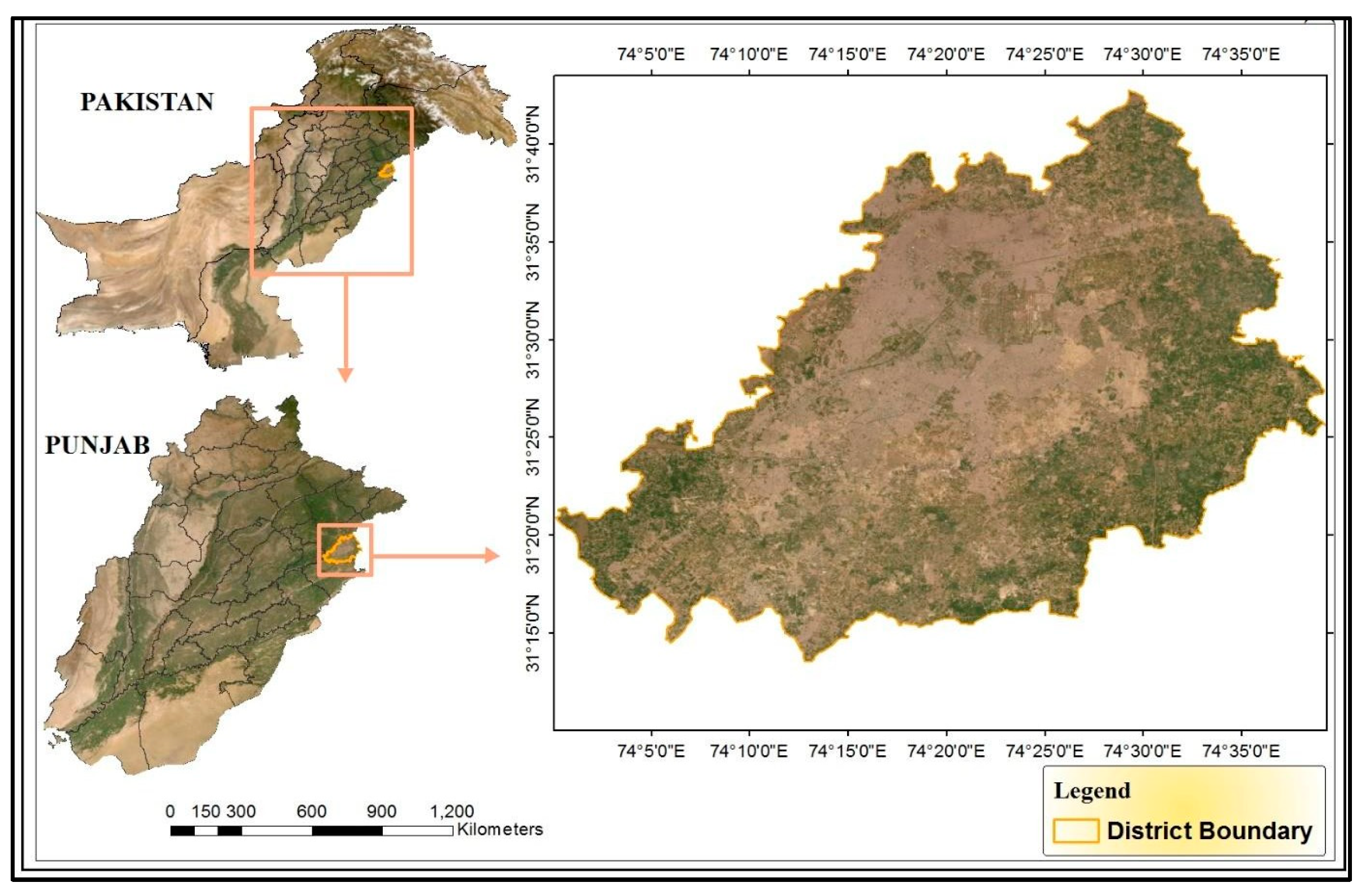
2.1. Study Area

Lahore is the capital of the Punjab Province, with geographical location 31°15′–31°45′ N and 74°01′–74°39′ E. The area covered by the city is about 1772 km2, which is continuously increasing. It is the second largest city in Pakistan after Karachi, and it has a population of more than 10 million. Migration activities, land use patterns, and urbanization have led to rapid growth and development of the city. The population growth trend and urban sprawl have caused multiple diseases, increased environmental pollution, and changed climatic patterns, which pose a threat to the sustainability of urban ecosystems [17,18,19]. Saleem et al. [17] reported that the tree cover in 1994 was 8% and a momentous decline brought it to 0.38% in 2014, which manifests an acute pressure on the urban green spaces of the city. Urbanization is the major triggering factor in Lahore’s environmental degradation [20,21]. The urban ecosystems’ degradation has become a challenge that is being neglected in Pakistan as compared to other developed or developing nations, which are eager and determined to fix the problem. Figure 1 shows the location map of the study area.

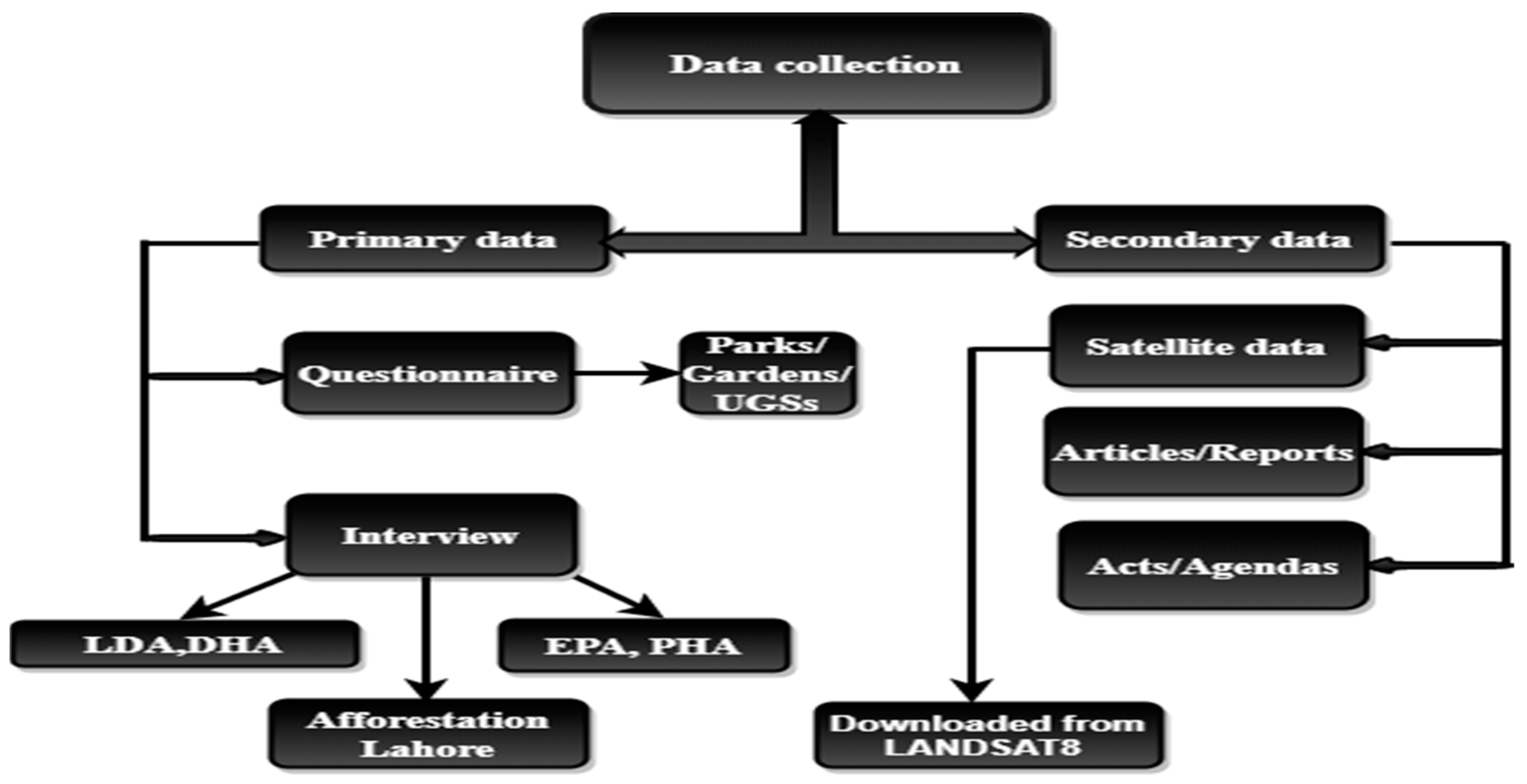
2.2. Primary Data Collection

This study employed both quantitative and qualitative data to investigate the research questions. For the questionnaire, twenty urban green spaces (gardens, parks, etc.) were selected as target areas with target respondents. The respondents included supervisors, malis (gardeners), maintenance persons, gatekeepers, etc., the people responsible for the day-to-day management of the urban green spaces. The reason for selecting these people as respondents was to capture authentic and ground-level information. A total of 19 questions were asked to gather the necessary information required for this study, and 65 questionnaires were filled. The questionnaire was designed in a closed-ended format and was researcher-administered because the target population was mostly illiterate individuals.
In Table 1, the names, roles/responsibilities, and affiliation (level of operation) of the authorities and agencies where the interviews were conducted are mentioned, while The names and monitoring levels of the urban green spaces are listed in Table 2 The interviews were unstructured in nature to obtain as much information as possible from the respondents. These contained 12 questions; the questions were designed in a way where the interviewer had leverage over the interviewee to ask questions within the response as well, and 15 interviews were conducted. The respondents were representatives of federally, provincially, or locally administrated organizations and authorities such as the Land Planning Head from LDA, the Director of DHA, the Director of EPA, etc. These agencies are responsible for forming, implementing, and monitoring the laws and policies to maintain the land use land cover, urban ecosystems, and natural environment of the city. These are four main regulating bodies of the city, and one entity, “Afforestation Lahore”, functions under the Government of Punjab (GOP). The questionnaire and interview questions are provided in the Supplementary Materials.

2.3. Secondary Data Collection

Secondary data were collected from various articles, research/theses, books, journals, and reports. The acts/agendas of the pertinent agencies were also helpful and handy. Modern and advanced technology has made data acquisition very easy and uncomplicated. As a significant part of secondary data, this research also used remotely sensed data over different periods. Landsat-8 data (Satellite images) of Lahore for the years 2010 and 2018 were downloaded from the USGS Earth Explorer in the form of bands by signing into the website (https://earthexplorer.usgs.gov/ (accessed on 1 December 2024)). Landsat-8 has two sensors: an Operational Land Imager (OLI) and a Thermal Infrared Sensor (TIRS) with a spatial resolution of 30 m and 11 bands. The stages of data collection are shown in Figure 2.

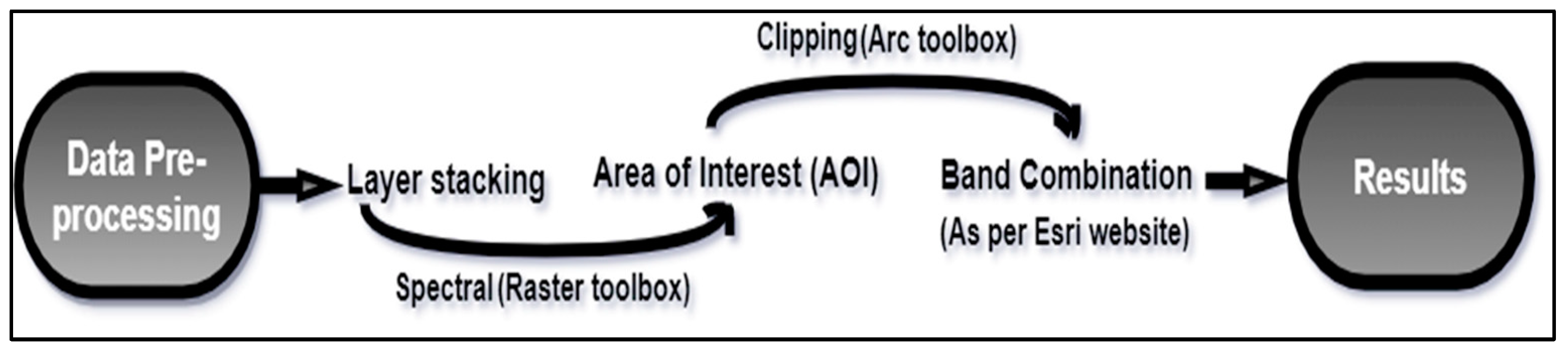
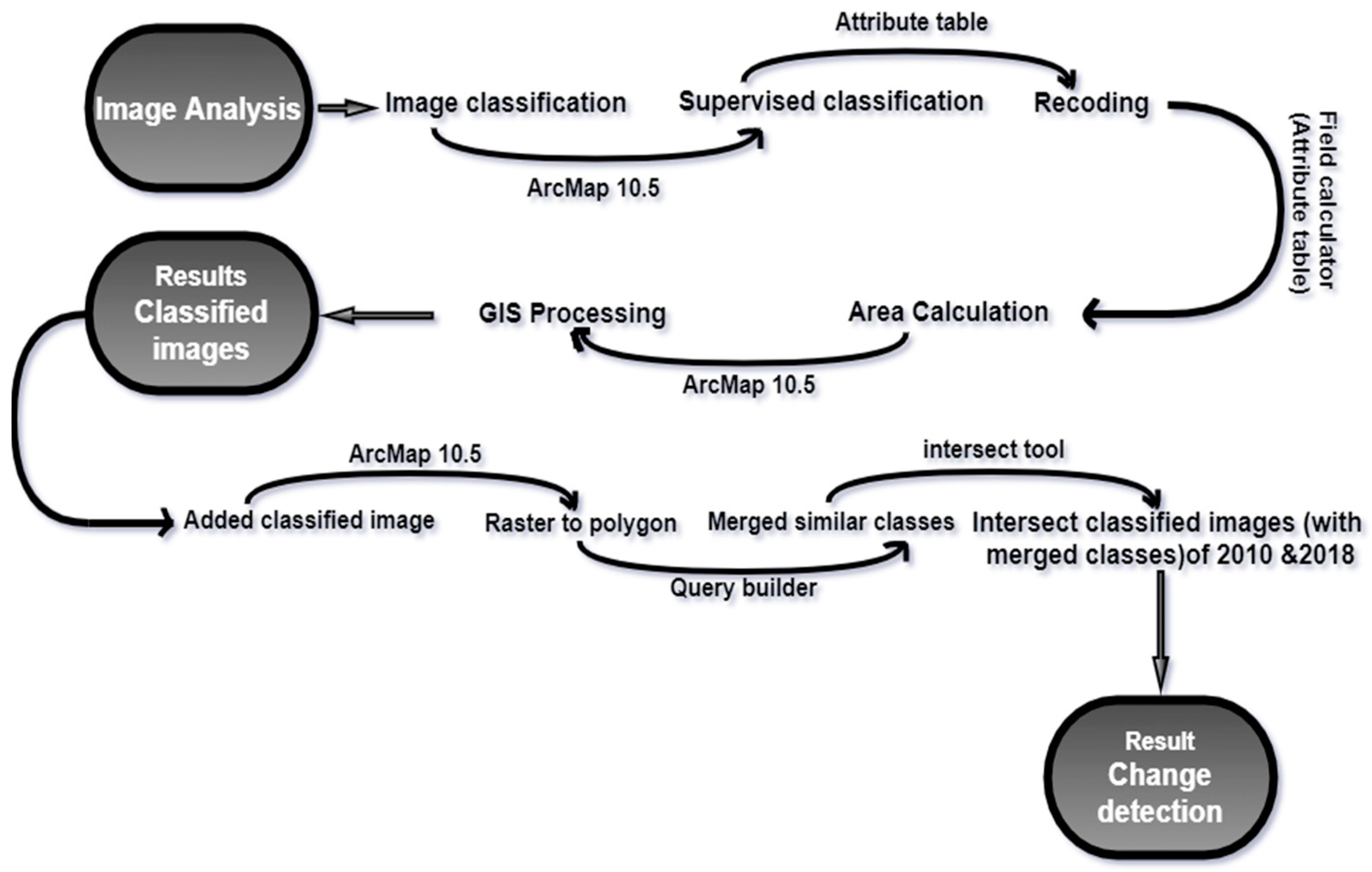
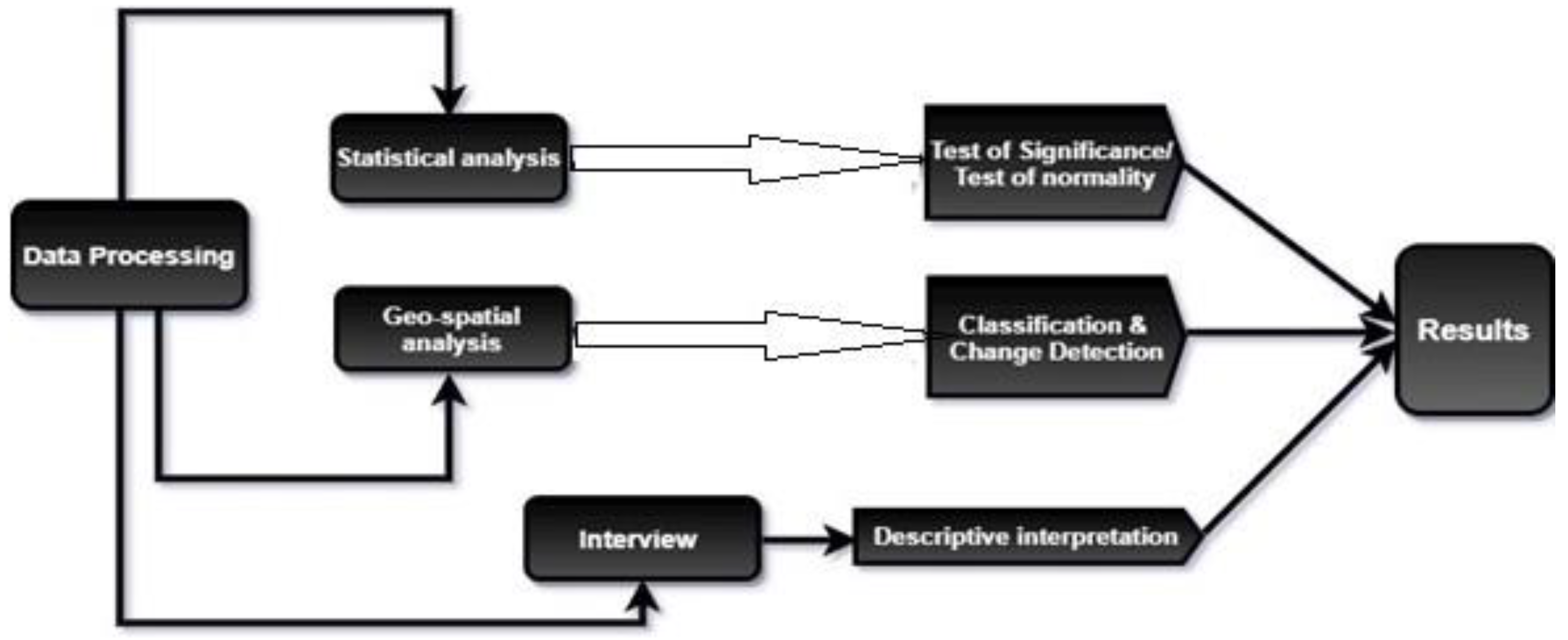
2.4. Processing of Primary and Secondary Data

In this section, various stages of data collection, along with the research design strategy will be discussed. Research design and its execution are significant and pivotal steps in achieving the research objectives. The main task of a researcher is to formulate the strategy coherently and logically blend it with various components of the study [22]. The authenticity of the research is determined by the type of data collected either from a ground survey or any valid secondary source. Thus, acquiring data is a vital stage in any research design [23].
After the pre-processing steps, which included layer stacking, extraction of area of interest (AOI), and band combination, the data were entered in the analysis stage (Figure 3). Supervised classification was carried out on satellite images of Lahore for the years 2010 and 2018 by using ArcMap 10.5. Five major classes of land use were determined: built-up area, agricultural land, green spaces, water bodies, and barren land. Each pixel was classified according to the class it represented on the ground. After classifying the pixels, the recoding of classes was carried out from the attribute table. The area was calculated for each class by using “calculate geometry”. After the processing of data, the results were classified images of 2010 and 2018. After classification, to check the change in land use, change detection was carried out using ArcMap. Change detection is a technique that can clearly show which land class has been changed into another class over the period. In this research, change was very transparent and comprehensible. The result was a single image explicitly depicting the change in the classes from 2010 to 2018 (Figure 4).
Statistical analysis used on primary data was carried out to check the normality of the data collected using a questionnaire and test of significance (t-test). A one-sample test was applied on multiple responses (assuming multiple null hypotheses) by keeping in view the objectives of this research; the value for the level of significance α = 0.05, the test value was 25, and there was a 95% confidence interval of the difference. Data processing techniques used for Primary and& Secondary data analysis are shown in Figure 5.

3. Results

3.1. Satellite Data Analysis

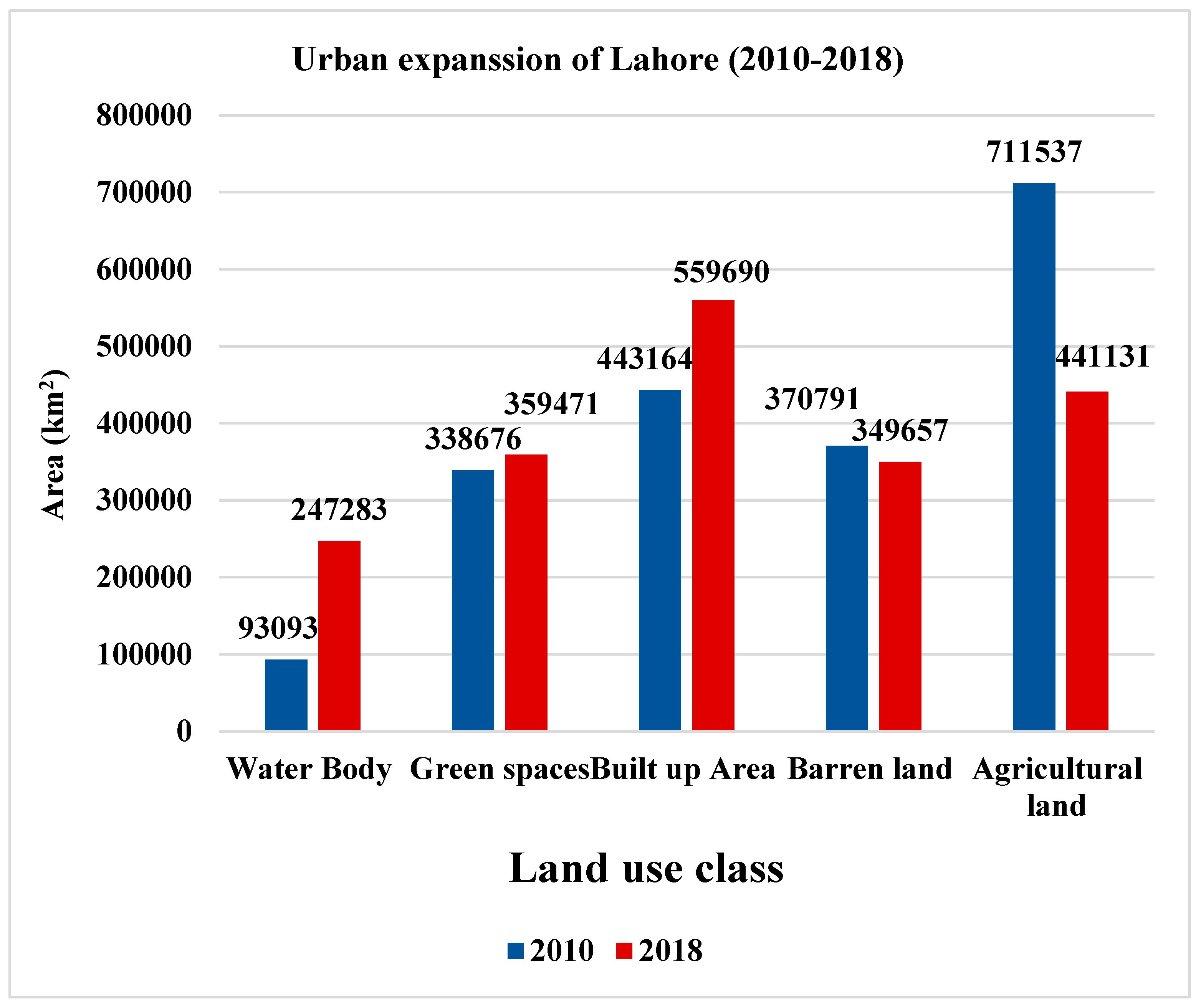
3.1.1. Urban Expansion Patterns of Lahore

Through a classification technique, the urban expansion pattern of Lahore from 2010 to 2018 was analyzed (Figure 6). The results revealed that the built-up area increased (26%) and most of the expansion took place to the eastern side of the city (right panel), which was primarily agricultural land (left panel). This is due to the construction of multiple societies to cater to the needs of the people who either migrated from nearby areas or the people who shifted their settlements from the center of the city/old city due to congestion, pollution, and extensive development. If we study the satellite image of the city, the utmost expansion was under DHA (DHA phases), and in some other societies like Paragon City in the north-east of the city. This expansion of built-up land is irregular and unmonitored.
Figure 7 presents the urban expansion and land use changes in Lahore from 2010 to 2018. The graph was generated using area values for each land use class, derived from the classification of satellite data through the attribute table.
From Figure 7, it can be observed that the built-up area has increased by almost 26%. This rapid growth in urban areas is identified as a real threat and challenge to natural ecosystems, habitat, biodiversity, and above all to the well-being of people [3]. Green spaces have increased by merely 6%. Furthermore, the water body also observed an increase of 16%. On the other hand, barren and agricultural land have observed a decrease of 5% to 38%, respectively. A study of the spatial and temporal evaluation of vegetation cover of Lahore suggests similar findings, such as a drastic decrease in tree cover from 8% in 1994 to 0.38% in 2014, while an increase in shrubs from 7% in 1994 to 15% in 2014 was observed [17]. For a sustainable urban ecosystem, the quantity and quality of green spaces available per person is an important aspect, which is 9 square meters per person according to the WHO standards [24], but in the case of Lahore residential societies, commercial and industrial settlements have invaded the parks, gardens and green spaces of the city, eventually resulting in the degradation of natural ecosystems and environmental deterioration [17]. Table 3 summarizes the area changes in land use classes from 2010 to 2018.

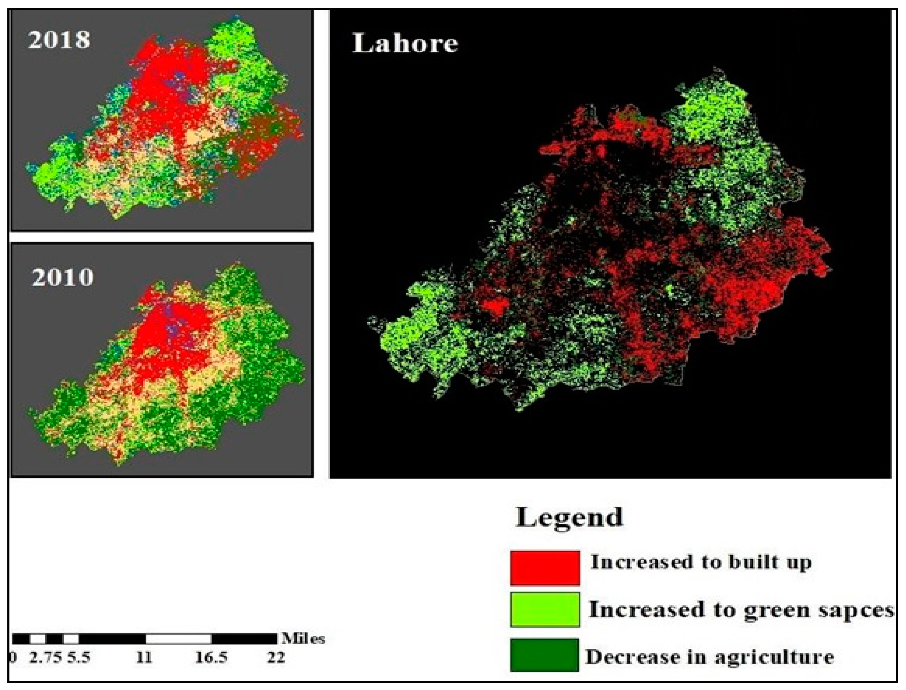
3.1.2. Analysis of Change Detection

Figure 8 presents the changes in land uses, highlighting areas that transitioned from one class to another between 2010 and 2018. Change detection precisely depicts which land class was converted and from which specific area. The analysis shows the expansion in built-up land and changes in green spaces and agricultural land. The red color in the map shows the increase in built-up land, the light green color shows an increase in green spaces, and the dark green color in the map shows that agricultural land has reduced. All the remaining classes are shown in black so that the change in predominant classes can be seen clearly.

3.2. Interview Results from Concerning Departments

3.2.1. Environmental Protection Agency

This section discusses the results from the interview part of data collection from different departments and authorities responsible for the maintenance of urban green spaces, environment protection, and land utilization and management of the city. During the interview, when asked about the extent to which the Environmental Protection Agency (EPA) is fulfilling its role in the ecosystem governance of Lahore, the respondents stated that the “EPA has a set of rules designed by ecologists, land planners, and environmentalists to make sure the sustainable development of the city and policies are revised with population growth and development”. The respondents’ feedback further revealed inconsistencies in policy implementation over time. While efforts were previously made to promote green spaces, these initiatives were not continued as expected. Instead of building upon existing policies, new strategies were introduced, leading to a shift in focus and approach. In response to the next question, “What functions are essential at the local level to preserve natural ecosystems?”, the respondent stated that “for the preservation of natural ecosystems and environment the authority has initiated the project to plant 10 billion trees and to control the air pollution. Furthermore, metal roads had been constructed throughout the city and an industrial emission control system has also been advised to be installed”.
Furthermore, the interviewer responded that the “EPA is currently facing funds issues due to which the policies cannot be completely implemented”. The respondents further said that “the current green spaces are claimed to be solely for the preservation of natural ecosystems but do not cater to the needs of the residents as authorities are facing a lack of resources and revenue”. Lastly, the interviewers were asked about the best alternative for the preservation of natural ecosystems. They replied that “sustainable development along with the control of air pollution through previously mentioned ways and the usage of environmentally friendly fuel can guarantee the preservation of the natural environment and ecosystems to an extent”. The authors of [25] showed that the maintenance of urban green spaces has a positive socio-economic impact on people’s lives and that people are aware of the vitality of urban green spaces in the city; this behavior of the residents can be helpful for city planners and developers to adopt the approaches which best fit the desires of citizens, hence making the city sustainable and resilient.

3.2.2. Park & Horticulture Authority (PHA)

To check the practicality of the monitoring system of the EPA, interviews of officials were conducted, which uncovered the realities. It was shown during the interview that the EPA furnishes the policies and rules for the PHA designed by economists, ecologists, and agriculturists. As far as revival and revision of policies by the EPA are concerned, it was reported that “policies are not revised as per the needs because of the unavailability of the land”. Furthermore, it was ascertained from the respondents’ answers that the policies are not followed as they were designed but modified according to the needs and the basic infrastructure remains same. One of the two PHA respondents reported that, currently, Lahore has 200,000 trees; moreover, in 2019, the PHA, with the collaboration of WWF Pakistan and other organizations, started a drive to plant 5000 indigenous trees in different localities in Lahore. In a total of 13 parks in Lahore, local trees including Arjun, bakain, sukh chain and kachnar had to be planted, but still the system has not reached its goal due to many flaws in the system. In response to the last question, “What should be the best alternative for the preservation of natural ecosystems along with development/urbanization?”, the respondent believed that “the government should highly discourage the concept of big houses, vertical buildings should be promoted, rooftop gardens and wall creepers should be a trend so that more land could be saved for plantation”. The authors of [26] analyzed the regulations of ecosystem services provided by urban green spaces in Barcelona, Spain. The authors argued synthetically that there are considerable scientific studies and research that define urban forests/urban green spaces as a main regulating factor of ecosystems and a significant entity that enhances and improves the quality of life but, unfortunately, this concept is always overlooked by the respective organizations during environmental policy-making processes [6,15].

3.2.3. Lahore Development Authority

In our view, rainwater harvesting, water conservation, and, above all, promotion of urban forestry and plantation are also part of the mission of the LDA. Multiple questions asked uncovered many facts about the authority’s functioning. The results gathered from the interviewer’s responses revealed that as per agenda there is the rule for keeping 7% of the land open/green and metropolitan wing of LDA monitors the implementation of the rule. As per demand, environmentalists, ecologists, geographers, and land use planners should be part of the panel that formulates the policies and rules but, unfortunately, the LDA does not pay any attention to this and hires a private team for a comprehensive analysis of the situation by keeping in view the future aspects as well; also, the policies are not revised accordingly.
The LDA faces shortages of revenue and resources as well, but there are other reasons for the inefficiency, such as there not being master plan from the government either for city planning or plantation, which makes land use planning more complicated. Moreover, the LDA aims to achieve the target that 15% of the area must be turned into green within 4–5 years, which is currently less than 1%. For new land use projects, the weightage of green spaces has also been increased. Kakakhel (2011) similarly mentioned that Pakistan has many frameworks with ambitious goals but still suffers from inefficacy and implementation delays owing to inefficient surveillance and inadequate evaluation of the problems. Also, a report by the World Bank in 2011 (Opportunities for a Clean and Green Pakistan: A Country Environment Analysis (CEA), June 2019) suggested that environmental degradation in Pakistan and increasing pollution has lowered the capacity of the people and adversely affected the well-being of the residents. The country has environmental laws [5] but needs to be given a constitutional shield to avoid ecosystem and environmental abuse; for example, Bhutan enjoys the status of a country preserving the natural environment because it granted constitutional protection to the environment and ecosystems [27].

3.2.4. Defense Housing Authority

To interrogate the role of DHA in maintaining the ecosystems of the area, an interview was conducted. The results revealed that apparently, DHA also follows the rule of law by the government, its executive board is responsible for the formulation of policies which comprises resident members as well who are privileged to accept or reject the design (faces incompetency and inconsistency), policies are revised under need-to-know basis. When asked about the failure of the system, the respondent revealed that there are many reasons which are the root causes for the failure of the systems and a hurdle to achieve the goals; for instance, “we face inconsistency and incompetency, there are not right people for the right jobs and the management system is also flawed but still we try to follow international standards”.

3.2.5. Afforestation Lahore

Afforestation Lahore is an initiative by the government of Punjab and functions under the commissioner’s office in Lahore. Lahore has lost 75% of its tree cover in the last 20 years and is now the second-worst city in the world in terms of air quality. Its mission is to plant indigenous and endangered species and enhance the flora and fauna of the city. The respondents claimed that they are ensuring that the locals and residents become active participants in the campaign. “Along with that we are much focused on the indigenous plantation, preservation of biodiversity, and natural flora and fauna of the city”, the respondents clarified.

3.3. Survey Results

The one sample t-test was applied to the questionnaire responses keeping in view this study’s objectives. Multiple null hypotheses were assumed and proved accordingly. The conclusion based on the hypothesis suggests that the number of visitors decreased in a few years and most of the visitors are those who visit occasionally, which shows a decreasing trend among daily visitors. Moreover, when governance and maintenance were tested, it was found that changes in government, bureaucratic set-up, and political instability significantly affect policy design and its implementation. Table 4 shows the t-test analysis results.

4. Discussion

The asymmetrical and unregulated growth of the city, with big housing societies and farmhouses, has led to poor governance and management of the city. The authorities should discourage the concept of big houses and encourage vertical development. The weightage of green spaces in residential or commercial areas should be enhanced and strictly followed. The idea of rooftop gardens can also be encouraged and can contribute significantly. The proposal of vertical development rather than horizontal infrastructure should be encouraged to make use of the minimum amount of land for maximum utilization. Residents should be motivated to enhance green spaces in any form, such as wall creepers and rooftop gardens, which can be instigated. The authorities can force societies to keep a fixed and sufficient amount of land green and can also impose the keeping of barren land green until constructed. The DHA also has a huge piece of land barren, not planted or ranched, which can be utilized as a green space until given a purpose.
Standards should be maintained, the implementation of policies should be monitored strictly, and the consequences for the violation of these must not be spared. The authorities can have their own mutually agreed upon and formulated master plan if not provided by the government to maintain the urban green spaces. Moreover, the communities must ensure that regular, even and symmetrical development is not irregular; strict actions must be immediately taken for illegal settlements to encourage the rule of law. The LDA has initiated the idea of the urban forest in the city; more concepts like this are needed, and deforestation in one part of the city must be compensated with reforestation in another part. Although Pakistan lags in digitalization and technology, as we see in many parts of the developed and developing world, the idea of a smart city still needs to be introduced, which combines digital solutions with nature-based solutions to counter the challenges of urbanization.

5. Conclusions

This study investigated the changes in land use and the efficiency of the land use governance system of the city. It was found that the city is expanding at an alarming rate and a significant increase in built-up land was seen in a short period of time. The role of the urban governance system and structural framework of the responsible authorities is to be beyond efficient. The changes in government and political instability hinder the efficacy of the policies. Maintenance policies lack efficacy and the monitoring systems are corrupt. The lack of coordination among stakeholders is one of the biggest reasons behind poor governance. Moreover, the condition of the urban green spaces is also evident in outdated policies and poor monitoring systems. Furthermore, the decline in the number of visitors is evident in the deteriorating condition of urban green spaces, which is discouraging, leading most visitors to be occasional. The irregular and unchecked expansion of the city, an increase in built-up land, and a significant decrease in urban green spaces have deteriorated the environmental health of the city. The authorities’ negligence and impractical approach to resolving the issue is largely responsible for this disaster. Strong coordination among relevant authorities and their willingness to resolve the problem, implementation of laws, accountability and educating people will help in the restoration of the urban ecosystems of the city.

Supplementary Materials

The following supporting information can be downloaded at: https://www.mdpi.com/article/10.3390/urbansci9050162/s1, (Questionnaire A. Interview questions used for data collection, Questionnaire B. Questionnaire used for data collection).

Author Contributions

Conceptualization, A.K.; methodology, A.K.; software, A.K. and M.A.; validation, A.K. and M.A.; formal analysis, A.K. and M.A.; resources, A.K.; data curation, A.K.; writing—original draft preparation, A.K.; writing—review and editing, U.M.; visualization, A.K. and M.A.; supervision, U.M.; project administration, U.M.; funding acquisition, U.M. All authors have read and agreed to the published version of the manuscript.

Funding

This research received no external funding.

Data Availability Statement

No new data were created or analyzed in this study. Data sharing is not applicable to this article.

Acknowledgments

The authors would like to acknowledge the respondents and the management of the government departments concerned, including the Environmental Protection Agency, Parks and Horticulture Authority, Lahore Development Authority, Defense Housing Authority, and Afforestation Lahore for their support. The authors would like to acknowledge the anonymous reviewers whose insightful comments and guidance significantly improved the quality of this manuscript and its language.

Conflicts of Interest

The authors declare no conflict of interest.

References

  1. Costanza, R.; Graumlich, L.J. Integrated History and Future of People on Earth (IHOPE): Building a Community Data Base and Testing the Resilience—Sustainability Hypothesis Across Scales; NCEAS: Santa Barbara, CA, USA, 2020; pp. 1–14. [Google Scholar]
  2. Repository, Z.O. Economic and Hedonic Pricing Studies Landscape Amenities and Local Development: A Review of Migration, Regional Economic and Hedonic Pricing Studies Research Unit Economics and Social Sciences, Swiss Federal Institute for Forest. Snow Inst. Environ. 2010, 70, 141–152. [Google Scholar]
  3. Kabisch, N.; Qureshi, S.; Haase, D. Human-Environment Interactions in Urban Green Spaces—A Systematic Review of Contemporary Issues and Prospects for Future Research. Environ. Impact Assess. Rev. 2015, 50, 25–34. [Google Scholar] [CrossRef]
  4. Martine, G.; McGranahan, G.; Montgomery, M.; Fernández-Castilla, R. The New Global Frontier: Urbanization, Poverty and Environment in the 21st Century; Earthscan: Oxford, UK, 2008; ISBN 9781849773157. [Google Scholar]
  5. Douglas, I.; James, P. Urban Ecology: An Introduction. Urban Ecol. An Introd. 2014, 1–476. [Google Scholar] [CrossRef]
  6. Alam, R.; Lovett, J.C. Prospects of Public Participation in the Planning and Management of Urban Green Spaces in Lahore: A Discourse Analysis. Sustainability 2019, 11, 3387. [Google Scholar] [CrossRef]
  7. Moricca, S.; Ragazzi, A. Fungal Endophytes in Mediterranean Oak Forests: A Lesson from Discula Quercina. Phytopathology 2008, 98, 380–386. [Google Scholar] [CrossRef]
  8. Schanze, J.; Olfert, A.; Tourbier, J.T.; Gersdorf, I.; Schwager, H. Existing Urban River Rehabilitation Schemes. Repos. PUJ 2012, 28, 60. [Google Scholar]
  9. Lhomme, P.; Michez, D.; Christmann, S.; Scheuchl, E.; El Abdouni, I.; Hamroud, L.; Ihsane, O.; Sentil, A.; Smaili, M.C.; Schwarz, M.; et al. The Wild Bees (Hymenoptera: Apoidea) of Morocco; Magnolia Press: Auckland, New Zealand, 2020; Volume 4892, ISBN 1597260401. [Google Scholar]
  10. LaDeau, S.L.; Allan, B.F.; Leisnham, P.T.; Levy, M.Z. The Ecological Foundations of Transmission Potential and Vector-Borne Disease in Urban Landscapes. Funct. Ecol. 2015, 29, 889–901. [Google Scholar] [CrossRef]
  11. Panduro, T.E.; Veie, K.L. Classification and Valuation of Urban Green Spaces-A Hedonic House Price Valuation. Landsc. Urban Plan. 2013, 120, 119–128. [Google Scholar] [CrossRef]
  12. Irwin, E.G. The Effects of Open Space on Residential Property Values. Land Econ. 2002, 78, 465–480. [Google Scholar] [CrossRef]
  13. Rana, I.A.; Bhatti, S.S. Lahore, Pakistan—Urbanization Challenges and Opportunities. Cities 2018, 72, 348–355. [Google Scholar] [CrossRef]
  14. Tillie, N.; van der Heijden, R. Advancing Urban Ecosystem Governance in Rotterdam: From Experimenting and Evidence Gathering to New Ways for Integrated Planning. Environ. Sci. Policy 2016, 62, 139–145. [Google Scholar] [CrossRef]
  15. Faisal, F.; Ali Shah, M. Sustainability: An Imperative for Improving Governance and Management in Pakistan. Pak. Econ. Soc. Rev. 2017, 55, 53–78. [Google Scholar]
  16. Khaliq-Uz-Zaman; Baloch, A.A. Urbanization of Arable Land in Lahore City in Pakistan: A Case-Study. Can. Soc. Sci. 2011, 7, 58–66. [Google Scholar] [CrossRef]
  17. Saleem, S.; Saleem, S. Spatial and Temporal Evolution of Vegetation Cover in Lahore, Pakistan. Bull. Environ. Sci. 2016, 1, 81–87. [Google Scholar]
  18. Mazhar, U.; Jin, S.; Hu, T.; Bilal, M.; Ali, M.A.; Atique, L. Long-Time Variation and Mechanism of Surface Energy Budget over Diverse Geographical Regions in Pakistan. IEEE J. Sel. Top. Appl. Earth Obs. Remote Sens. 2022, 15, 1–13. [Google Scholar] [CrossRef]
  19. Mazhar, U.; Jin, S.; Bilal, M. Land Surface Temperature Variability over Various Land Covers in Punjab (Pakistan) from MODIS Data. In Proceedings of the 2021 28th International Conference on Geoinformatics, Nanchang, China, 8–10 August 2021; pp. 1–5. [Google Scholar]
  20. Anwar, M.; Shirazi, S.A.; Mazhar, U. Spatial Distribution and Health Risk Assessment of Groundwater Pollution in Kotlakhpat Industrial Complex, Lahore. Water. Air. Soil Pollut. 2024, 235, 157. [Google Scholar] [CrossRef]
  21. Anwar, M.; Mazhar, U. Assessing Pollution Vulnerability in Groundwater: A Case Study of Kala Shah Kaku Industrial Complex. Water Pract. Technol. 2024, 19, 3022–3030. [Google Scholar] [CrossRef]
  22. Lecuyer, M.; Atlidakis, V.; Geambasu, R.; Hsu, D.; Jana, S. Certified Robustness to Adversarial Examples with Differential Privacy. In Proceedings of the 2019 IEEE Symposium on Security and Privacy (SP), San Francisco, CA, USA, 20–22 May 2019; pp. 656–672. [Google Scholar] [CrossRef]
  23. Hollweck, T.; Yin, R.K. Case Study Research Design and Method (5th Ed.). Can. J. Progr. Eval. 2015, 30, 108–110. [Google Scholar] [CrossRef]
  24. Maryanti, M.R.; Khadijah, H.; Uzair, A.M.; Ghazali, M.A.R.M.M. The Urban Green Space Provision Using the Standards Approach: Issues and Challenges of Its Implementation in Malaysia. In Sustainable Development and Planning VIII; WIT Press: Southampton, UK; Boston, MA, USA, 2016; Volume 1. [Google Scholar]
  25. Sajjad, S.H.; Batool, R.; Talha Qadri, S.M.; Shirazi, S.A.; Shakrullah, K. The Long-Term Variability in Minimum and Maximum Temperature Trends and Heat Island of Lahore City, Pakistan. Sci. Int. J. 2015, 27, 1321–1325. [Google Scholar]
  26. Baró, F.; Chaparro, L.; Gómez-Baggethun, E.; Langemeyer, J.; Nowak, D.J.; Terradas, J. Contribution of Ecosystem Services to Air Quality and Climate Change Mitigation Policies: The Case of Urban Forests in Barcelona, Spain. Ambio 2014, 43, 466–479. [Google Scholar] [CrossRef]
  27. Khwaja, M.A.; Umer, F.; Shaheen, N.; Sherazi, A.; Haq Shaheen, F. Air Pollution Reduction and Control in South Asia Sustainable Development Policy Institute (SDPI). Work. Pap. Ser. 121 2012, 31, 51–68. [Google Scholar]
Figure 1. Lahore city.
Urbansci 09 00162 g001
Figure 2. Data collection for research design.
Urbansci 09 00162 g002
Figure 3. Pre-processing of satellite data.
Urbansci 09 00162 g003
Figure 4. Stages for satellite image analysis.
Urbansci 09 00162 g004
Figure 5. Data processing techniques used for primary and secondary data analysis.
Urbansci 09 00162 g005
Figure 6. Urban expansion patterns in Lahore 2010–2018.
Urbansci 09 00162 g006
Figure 7. Changes in land use classes in Lahore from 2010 to 2018.
Urbansci 09 00162 g007
Figure 8. Change detection in land utilization from 2010 to 2018.
Urbansci 09 00162 g008
Table 1. Departments from where interviews were conducted.
DepartmentRoleLevel
Parks & Horticulture Authority (PHA)Environment and ecosystem protectionProvincial
Environment Protection Agency (EPA)Environment protectionProvincial
Defense Housing Authority (DHA)Land regulationFederal
Lahore Development Authority (LDA)Land regulationProvincial
Afforestation Lahore (AL)Plantation and afforestationUnder GOP
Table 2. Urban green spaces for the questionnaire.
NoUrban Green Spaces (Parks/Garden etc.)Monitoring Level
1Jilani parkPHA
2Gulshan Iqbal parkPHA
3Bhagh-e-JinnahPHA
4Jam-e-Shiren parkLocal
5Greater Iqbal parkPHA
6Nwaz Sharif parkLocal
7National parkPHA
8Arfa Karim parkPHA
9Kalma chowk gardenPHA
10Nasir bhaghPHA
11Jallo parkPHA
12Sozo water parkPHA
13Nishtar parkPHA
14Model town parkLocal
15Hazuri bhaghPHA
16Victoria parkPHA
17Saint Mary parkLocal
18Sheeba parkPHA
19Askari parkDHA
20Babar parkLocal
Table 3. Area changes in land use classes.
Land Use ClassArea (m2) 2010Area (m2) 2018
Built-up area443,164559,690
Agricultural land711,537441,131
Green space338,676359,471
Barren land370,791349,657
Water body93,093247,283
Table 4. Showing t-test analysis results.
Test Value = 65
TdfSigMean Difference95% Confidence Interval
LowerUpper
Most visitors−230.240240.000−23.480−23.69−23.27
No. of visitors in the past 5 years−142.648240.000−24.320−24.67−23.97
Regular monitoring−188.737240.000−24.560−24.83−24.29
Effect of change
in government on policies
−168.291240.000−23.800−24.09−23.51
Corruption−24.275240.000−23.640−23.84−23.44
Effect of political instability on the flow of funds−201.391240.000−24.720−24.97−24.47
Disclaimer/Publisher’s Note: The statements, opinions and data contained in all publications are solely those of the individual author(s) and contributor(s) and not of MDPI and/or the editor(s). MDPI and/or the editor(s) disclaim responsibility for any injury to people or property resulting from any ideas, methods, instructions or products referred to in the content.

