
Microclimatic Landscape Architecture: From Theory to Application


Abstract
:1. Introduction
- Investigating and developing principles and guidelines. It discusses the broad and fundamental laws of microclimatic design, as well as provides a broad indication and outline of conduct. It is divided into two sections, the first of which contains principles and guidelines for achieving a specific goal, such as tree species selection guidelines [24]. The other provides principles and guidelines for a broad goal, such as creating thermally comfort outdoor space [25,26].
- Discussing and recommending strategies. It was primarily concerned with making specific suggestions and recommendations to improve thermal comfort or energy efficiency. There are two types of strategies: object-oriented strategies and goal-oriented strategies. Object-oriented strategies focused on landscape elements (e.g., vegetation, water, etc.) and microclimate parameters (e.g., wind), whereas goal-oriented strategies concentrate on one or more specific goals, such as passive cooling strategies and thermal comfort mitigating strategies [27,28,29]. Changes in urban geometry, planting vegetation, using cool surfaces, and incorporating bodies of water are all common object-oriented strategies [12].
- Mapping, the process of creating a map. This method effectively connects necessary microclimate information with spatial information and clearly represents the resulting information. It can be divided into three approaches: directly creating maps using microclimatic software (such as ENVI-met software, Rayman software, etc.), mapping using non-software methods (such as photographic and video techniques), and combining maps obtained in various ways to create new maps using ArcGIS software [23].
- Applying various evaluation methods. Evaluation is an important part of using microclimates in landscape architecture because it provides a systematic way to examine an intervention or a practice to see how well it accomplishes its objectives. It can be divided into three parts: (1) examine the effect of constructed environments, (2) evaluate simulation outcomes, and (3) evaluate a specific type of landscape. These methods all play their respective roles at various stages of design. Mapping dominates the process of site inventory and analysis, principles and guidelines are primarily used in design development, strategies are primarily used in detail design, and evaluation is focused on design assessment [23].
2. Methods
2.1. Step 1: Understanding the Needs of Designers
2.2. Step 2: Integrated Research on Urban Microclimate Factors
2.3. Step 3: Development of Guidance Methods for Better Design
2.4. Step 4: Developing User-Friendly Tools
3. Results
3.1. The Needs of Designers
3.1.1. Basic Information of the Questionnaire
3.1.2. Understanding and Application of Microclimate
Question 1 to Question 2: Attitudes towards Microclimate
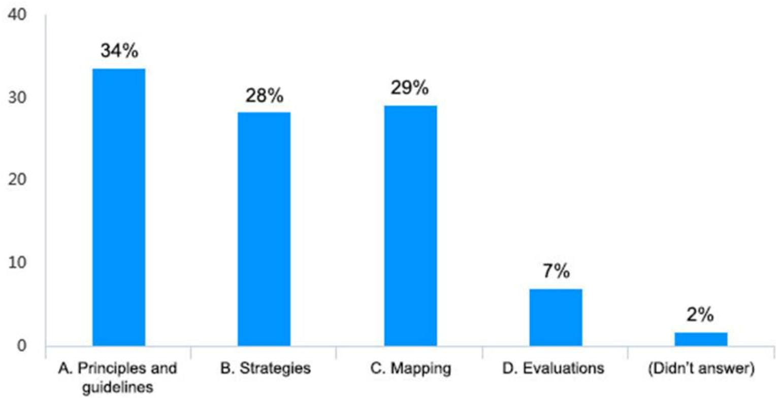
Question 3 to Question 6: The Most Commonly Used Microclimatic Design Method and Its Use according to Which Design Stage
Question 7 to Question 13: Attitudes towards Microclimate Design Prototypes and Microclimate Evaluation Software
Question 14: Interviewees’ Thoughts on the Use of Microclimate
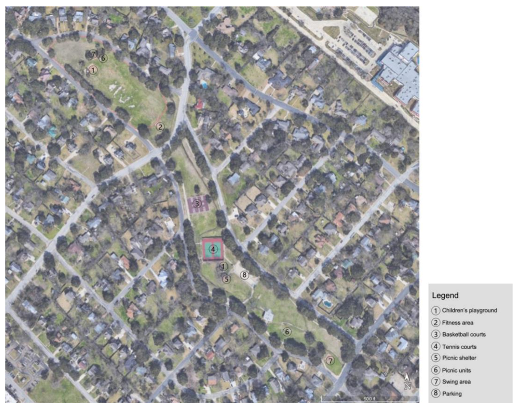
3.2. Urban Microclimate Measurements
3.2.1. Maxi-Met Station
3.2.2. Thermal Camera
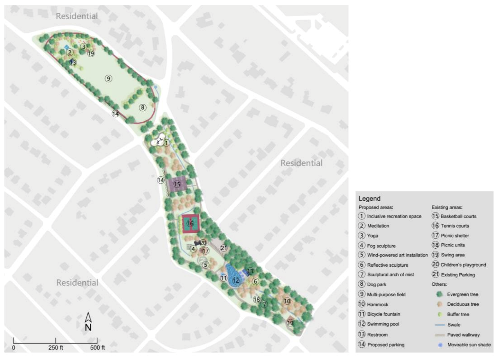
3.3. Guidance Methods: Modeling and Simulation
3.3.1. ENVI-Met
3.3.2. COMFA Models
4. Discussion
4.1. Needs of Designers
4.2. Integrated Research and Design Guidance
4.3. User-Friendly Tools
4.4. Limitation and Future Research
5. Conclusions
Author Contributions
Funding
Data Availability Statement
Acknowledgments
Conflicts of Interest
Appendix A
- Will you consider microclimate factors in your landscape design work?
- Never
- Rarely
- Sometime
- Often
- Always
- Do you agree or disagree with the following statement: It is essential to consider microclimate issues when designing a landscape?
- Strongly disagree
- Disagree
- Neutral
- Agree
- Strongly agree
- Do you understand the following common methods for incorporating microclimate into landscape design practice? Principles and guidelines, strategies, mapping, and evaluations. (Question skip logic: if you select Yes, jump to question 4; if you select No, jump to question 5.)
- Yes
- No
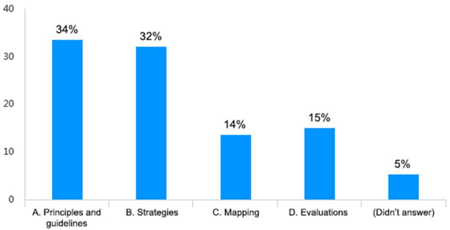
- Please select the method you use most frequently in your work:
- Principles and guidelines
- Strategies
- Mapping
- Evaluations
- Based on the following description, please select the method you use most frequently in your work:The principles and guidelines method refers to using basic microclimate design rules and adhering to a broad indication and outline of conduct during the design process; the strategies method refers to the use of specific methods that can improve the site’s microclimate environment rather than just tips that help guide in the right direction; the mapping method refers to the process of connecting microclimate information with the necessary spatial information through mapping, in order to display the final information more clearly; and the evaluations method refer to the use of software simulations to predict or test whether the microclimate of the practical project meets the expected goal.
- Principles and guidelines
- Strategies
- Mapping
- Evaluations
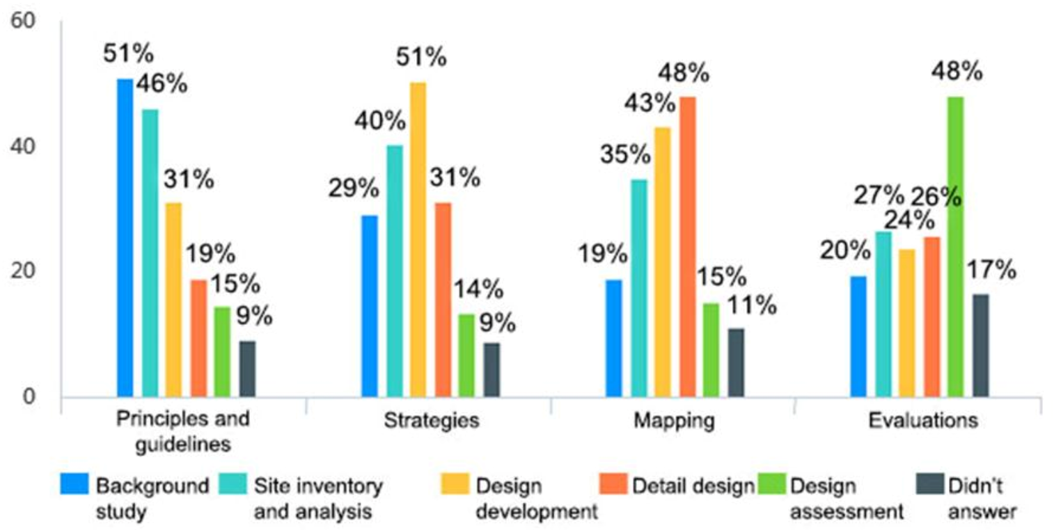
- If you use the methods listed above, at what stage of the design process do you use them (multiple choice)?
Background Study Site Inventory and Analysis Design Development Detail Design Design Assessment Principles and guidelines □ □ □ □ □ Strategies □ □ □ □ □ Mapping □ □ □ □ □ Evaluations □ □ □ □ □ - Do you agree or disagree with the following statement: An evidence-based microclimatic design prototype would be useful in assisting your learning microclimatic design?
- Strongly disagree
- Disagree
- Neutral
- Agree
- Strongly agree
- Do you know the microclimate design software ENVI-met? (Question skip logic: if you select Yes, jump to question 9; if you select No, jump to question 10)
- Yes
- No
- How important do you consider ENVI-met to be in landscape design?
- Very unimportant
- Unimportant
- Neutral
- Important
- Very important
- Based on the following description, how important do you consider ENVI-met to be in landscape design?ENVI-met is a simulation software about urban microclimate. The software can carry out computer simulations on the microclimate of small and medium-scale cities, comprehensively consider the influence factors of the microclimate, and can evaluate the influence of environmental factors such as the atmosphere, vegetation, buildings, and materials.
- Very unimportant
- Unimportant
- Neutral
- Important
- Very important
- Do you know the COMFA model? (Question skip logic: if you select Yes, jump to question 12; if you select No, jump to question 13)
- Yes
- No
- How important do you consider COMFA model to be in landscape design?
- Very unimportant
- Unimportant
- Neutral
- Important
- Very important
- Based on the following description, how important do you consider COMFA model to be in landscape design?COMFA model is a tool for evaluating the thermal comfort of the human body, mainly used in the landscape field. Its characteristic is to provide the corresponding thermal comfort assessment by calculating the human energy balance under a given outdoor space condition.
- Very unimportant
- Unimportant
- Neutral
- Important
- Very important
- What are your thoughts on the use of microclimate in landscape design?
References
- Eliasson, I. The use of climate knowledge in urban planning. Landsc. Urban Plan. 2000, 48, 31–44. [Google Scholar] [CrossRef]
- Grimmond, S.U. Urbanization and global environmental change: Local effects of urban warming. Geogr. J. 2007, 173, 83–88. [Google Scholar] [CrossRef]
- Lenzholzer, S.; Brown, R.D. Climate-responsive landscape architecture design education. J. Clean. Prod. 2013, 61, 89–99. [Google Scholar] [CrossRef]
- Tewari, M.; Yang, J.; Kusaka, H.; Salamanca, F.; Watson, C.; Treinish, L. Interaction of urban heat islands and heat waves under current and future climate conditions and their mitigation using green and cool roofs in New York City and Phoenix, Arizona. Environ. Res. Lett. 2019, 14, 34002. [Google Scholar] [CrossRef]
- Kondo, K.; Mabon, L.; Bi, Y.; Chen, Y.; Hayabuchi, Y. Balancing conflicting mitigation and adaptation behaviours of urban residents under climate change and the urban heat island effect. Sustain. Cities Soc. 2021, 65, 102585. [Google Scholar] [CrossRef]
- Heaviside, C.; Macintyre, H.; Vardoulakis, S. The urban heat island: Implications for health in a changing environment. Curr. Environ. Health Rep. 2017, 4, 296–305. [Google Scholar] [CrossRef]
- Vargo, J.; Stone, B.; Habeeb, D.; Liu, P.; Russell, A. The social and spatial distribution of temperature-related health impacts from urban heat island reduction policies. Environ. Sci. Policy 2016, 66, 366–374. [Google Scholar] [CrossRef]
- Altunkasa, C.; Uslu, C. Use of outdoor microclimate simulation maps for a planting design to improve thermal comfort. Sustain. Cities Soc. 2020, 57, 102137. [Google Scholar] [CrossRef]
- Lee, Y.Y.; Din, M.F.M.; Ponraj, M.; Noor, Z.Z.; Iwao, K.; Chelliapan, S. Overview of urban heat island (uhi) phenomenon towards human thermal comfort. EEMJ 2017, 16, 2097–2111. [Google Scholar]
- El-Bardisy, W.M.; Fahmy, M.; El-Gohary, G.F. Climatic sensitive landscape design: Towards a better microclimate through plantation in public schools, Cairo, Egypt. Procedia Soc. Behav. Sci. 2016, 216, 206–216. [Google Scholar] [CrossRef] [Green Version]
- Declet-Barreto, J.; Brazel, A.J.; Martin, C.A.; Chow, W.T.; Harlan, S.L. Creating the park cool island in an inner-city neighborhood: Heat mitigation strategy for Phoenix, AZ. Urban Ecosyst. 2013, 16, 617–635. [Google Scholar] [CrossRef]
- Lai, D.; Liu, W.; Gan, T.; Liu, K.; Chen, Q. A review of mitigating strategies to improve the thermal environment and thermal comfort in urban outdoor spaces. Sci. Total Environ. 2019, 661, 337–353. [Google Scholar] [CrossRef]
- Zhang, A.; Bokel, R.; van den Dobbelsteen, A.; Sun, Y.; Huang, Q.; Zhang, Q. An integrated school and schoolyard design method for summer thermal comfort and energy efficiency in Northern China. Build. Environ. 2017, 124, 369–387. [Google Scholar] [CrossRef]
- Ebrahimabadi, S.; Nilsson, K.L.; Johansson, C. The problems of addressing microclimate factors in urban planning of the subarctic regions. Environ. Plan. B Plan. Des. 2015, 42, 415–430. [Google Scholar] [CrossRef]
- Brown, R.D. Ameliorating the effects of climate change: Modifying microclimates through design. Landsc. Urban Plan. 2011, 100, 372–374. [Google Scholar] [CrossRef]
- Brown, R.D.; Vanos, J.; Kenny, N.; Lenzholzer, S. Designing urban parks that ameliorate the effects of climate change. Landsc. Urban Plan. 2015, 138, 118–131. [Google Scholar] [CrossRef]
- Yang, W.; Lin, Y.; Li, C.Q. Effects of landscape design on urban microclimate and thermal comfort in tropical climate. Adv. Meteorol. 2018, 2018, 2809649. [Google Scholar] [CrossRef]
- Srivanit, M.; Hokao, K. Evaluating the cooling effects of greening for improving the outdoor thermal environment at an institutional campus in the summer. Build. Environ. 2013, 66, 158–172. [Google Scholar] [CrossRef]
- Sun, S.; Xu, X.; Lao, Z.; Liu, W.; Li, Z.; García, E.H.; He, L.; Zhu, J. Evaluating the impact of urban green space and landscape design parameters on thermal comfort in hot summer by numerical simulation. Build. Environ. 2017, 123, 277–288. [Google Scholar] [CrossRef]
- Xiong, Y.; Zhang, J.; Xu, X.; Yan, Y.; Sun, S.; Liu, S. Strategies for improving the microclimate and thermal comfort of a classical Chinese garden in the hot-summer and cold-winter zone. Energy Build. 2020, 215, 109914. [Google Scholar] [CrossRef]
- Transsolar. Available online: https://transsolar.com/projects/redevelopment-place-de-la-republique (accessed on 18 October 2021).
- Transsolar. Available online: https://transsolar.com/projects/outdoor-comfort-with-dry-mist-at-singapore-mandai-zoo (accessed on 18 October 2021).
- Lin, J.; Brown, R.D. Integrating Microclimate into Landscape Architecture for Outdoor Thermal Comfort: A Systematic Review. Land 2021, 10, 196. [Google Scholar] [CrossRef]
- Boc, V.I. Tree Species Selection Guidelines from the Pespective of Bioclimatic Landscape Design. Sci. Pap. Ser. B Hortic. 2018, 62, 541–550. [Google Scholar]
- Brown, R.D.; Gillespie, T.J. Microclimatic Landscape Design: Creating Thermal Comfort and Energy Efficiency; Wiley: New York, NY, USA, 1995; Volume 1, pp. 81–91. [Google Scholar]
- Lenzholzer, S. Research and design for thermal comfort in Dutch urban squares. Resour. Conserv. Recycl. 2012, 64, 39–48. [Google Scholar] [CrossRef]
- Attia, S. The Role of Landscape Design in Improving the Microclimate in Traditional Courtyard Buildings in Hot Arid Climates. In Proceedings of the 23rd International Conference on Passive and Low Energy Architecture-PLEA 2006, PLEA-Université de Genève-Groupe Énergie, Geneva, Switzerland, 6–8 September 2006; pp. 22–24. [Google Scholar]
- Ak, M.K.; Ozdede, S. Urban Landscape Design and Planning Related to Wind Effects. Oxid. Commun. 2016, 39, 699–710. [Google Scholar]
- Ogunsote, O.O.; Prucnal-Ogunsote, B. Control of Tropical Microclimates through Landscape Design: Concepts and Methods. In Proceedings of the National Workshop on Landscape Design for the Federal Capital Development Authority, Abuja by the Department of Architecture, Ahmadu Bello University, Zaria, Nigeria, 17 April–10 May 2002. [Google Scholar]
- Bherwani, H.; Singh, A.; Kumar, R. Assessment methods of urban microclimate and its parameters: A critical review to take the research from lab to land. Urban Clim. 2020, 34, 100690. [Google Scholar] [CrossRef]
- China’s Landscape Architects Undo the Damage. Available online: https://dirt.asla.org/2012/05/24/chinas-landscape-architects-undo-the-damage-of-development/ (accessed on 18 October 2021).
- Chang, C.R.; Li, M.H. Effects of urban parks on the local urban thermal environment. Urban For. Urban Green. 2014, 13, 672–681. [Google Scholar] [CrossRef]
- Campbell, C.S. Water in Landscape Architecture; Van Nostrand Reinhold: New York, NY, USA, 1978; pp. 23–32. [Google Scholar]
- Li, J.; Liu, J.; Srebric, J.; Hu, Y.; Liu, M.; Su, L.; Wang, S. The Effect of Tree-Planting Patterns on the Microclimate within a Courtyard. Sustainability 2019, 11, 1665. [Google Scholar] [CrossRef] [Green Version]
- Jin, H.; Shao, T.; Zhang, R. Effect of water body forms on microclimate of residential district. Energy Procedia 2017, 134, 256–265. [Google Scholar] [CrossRef]
- Boukhelkhal, I.; Bourbia, P.F. Thermal comfort conditions in outdoor urban spaces: Hot dry climate-Ghardaia-Algeria. Procedia Eng. 2016, 169, 207–215. [Google Scholar] [CrossRef]
- Coccolo, S.; Mauree, D.; Naboni, E.; Kaempf, J.; Scartezzini, J.L. On the impact of the wind speed on the outdoor human comfort: A sensitivity analysis. Energy Procedia 2017, 122, 481–486. [Google Scholar] [CrossRef]


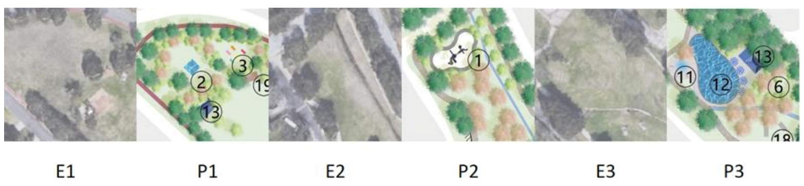
| Budget W/m2 | Description |
|---|---|
| <−150 | Would prefer to be much warmer |
| −150 to −50 | Would prefer to be warmer |
| −50 to 50 | No change |
| 50 to 150 | Would prefer to be cooler |
| >150 | Would prefer to be much cooler |
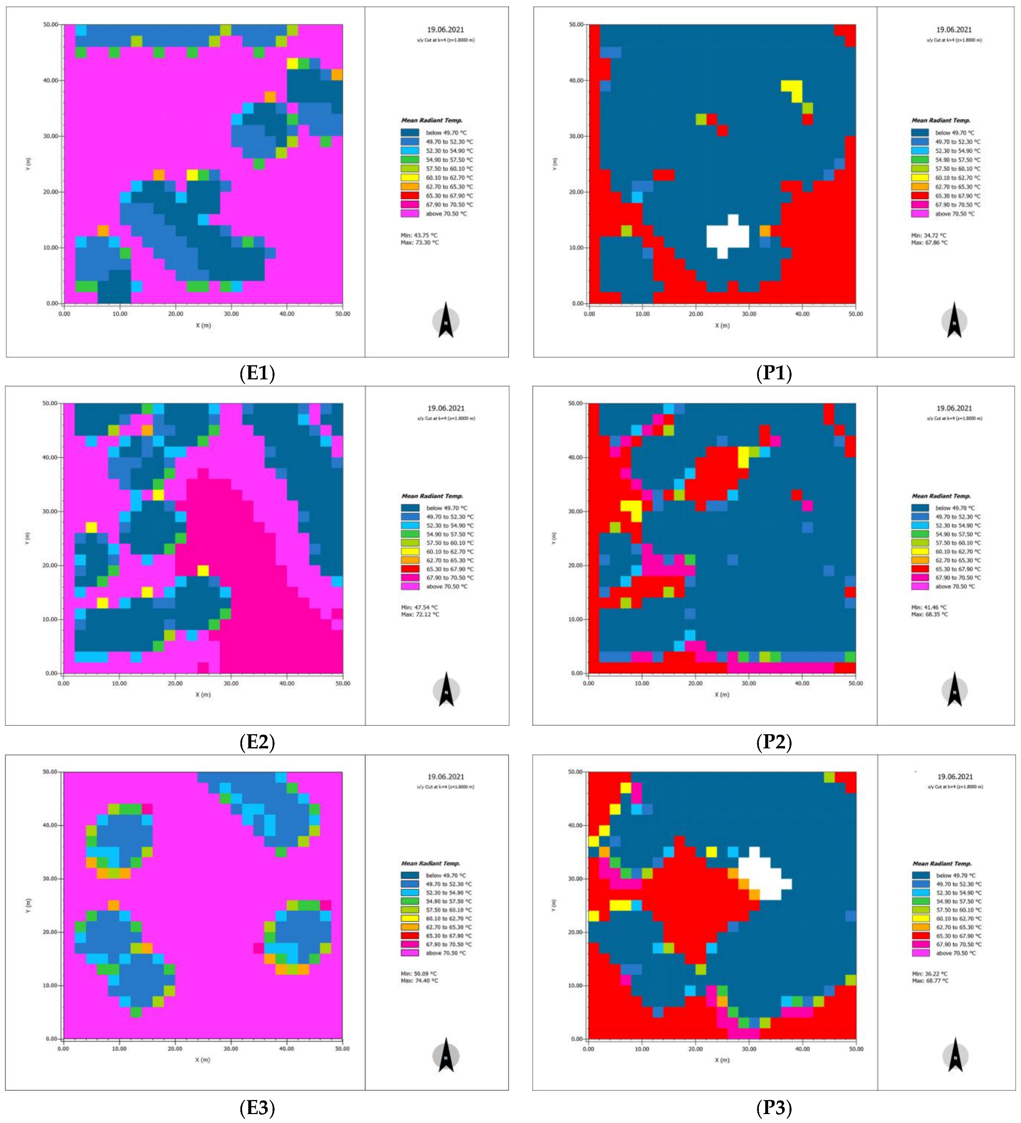
| Location | E1 | P1 | E2 | P2 | E3 | P3 |
|---|---|---|---|---|---|---|
| Time | 1:54–2:04 | 1:54–2:04 | 1:40–1:50 | 1:40–1:50 | 1:40–1:50 | 1:40–1:50 |
| Condition | In the sun out of the wind | In the sun out of the wind | In the sun in the wind | In the sun in the wind | In the sun in the wind | In the sun in the wind |
| Wind speed (m/s) | 0.9 | 0.9 | 1.2 | 1.2 | 1.2 | 1.2 |
| Wind direction | 215 | 215 | 152 | 152 | 152 | 152 |
| Temperature (°C) | 33.6 | 33.6 | 33.5 | 33.5 | 33.5 | 33.5 |
| Location | E1 | P1 | E2 | P2 | E3 | P3 |
|---|---|---|---|---|---|---|
| Air temperature (°C) | 32 | 31 | 31 | 31 | 32 | 31 |
| Wind speed (m/s) | 0.6 | 0.5 | 1.1 | 0.7 | 0.9 | 0.7 |
| Solar radiation (W/m2) | 635 | 291 | 567 | 289 | 701 | 368 |
| Relative Humidity (%) | 55 | 60 | 55 | 58 | 55 | 57 |
| Location | E1 | P1 | E2 | P2 | E3 | P3 |
|---|---|---|---|---|---|---|
| Energy Budget Values (W/m2) | 184 | 116 | 162 | 118 | 199 | 134 |
| What the Budget Values mean for a Standing Adult | Would prefer to be much cooler | Would prefer to be cooler | Would prefer to be much cooler | Would prefer to be cooler | Would prefer to be much cooler | Would prefer to be cooler |
Publisher’s Note: MDPI stays neutral with regard to jurisdictional claims in published maps and institutional affiliations. |
© 2022 by the authors. Licensee MDPI, Basel, Switzerland. This article is an open access article distributed under the terms and conditions of the Creative Commons Attribution (CC BY) license (https://creativecommons.org/licenses/by/4.0/).
Share and Cite
Lin, J.; Li, D.; Brown, R.D. Microclimatic Landscape Architecture: From Theory to Application. Urban Sci. 2022, 6, 9. https://doi.org/10.3390/urbansci6010009
Lin J, Li D, Brown RD. Microclimatic Landscape Architecture: From Theory to Application. Urban Science. 2022; 6(1):9. https://doi.org/10.3390/urbansci6010009
Chicago/Turabian StyleLin, Jiawei, Dongying Li, and Robert D. Brown. 2022. "Microclimatic Landscape Architecture: From Theory to Application" Urban Science 6, no. 1: 9. https://doi.org/10.3390/urbansci6010009
APA StyleLin, J., Li, D., & Brown, R. D. (2022). Microclimatic Landscape Architecture: From Theory to Application. Urban Science, 6(1), 9. https://doi.org/10.3390/urbansci6010009