Spatial Information Gaps on Deprived Urban Areas (Slums) in Low-and-Middle-Income-Countries: A User-Centered Approach
Abstract
:1. Introduction
2. Materials and Methods
2.1. Setup of the User Needs Assessment
- a.
- At the international level, the information needs assessment covers intergovernmental organizations, such as UN-Habitat or the European Commission, and the global research community working on deprived areas.
- b.
- At the national and in particular local/city level, planning departments and planning ministries (government), as well as the private sector (e.g., planning or GIS consultants), are covered that require timely information about deprived areas, e.g., to map the dynamics and characteristics of deprived areas for facilitating science-based policymaking.
- c.
- At the community level, community-based organizations (CBOs) and non-governmental organizations (NGOs) are covered to understand data needs for intra-slum communities, making these places visible in a responsible way, and helping to promote the improvement of their living conditions.
2.2. Data Collection on User Needs
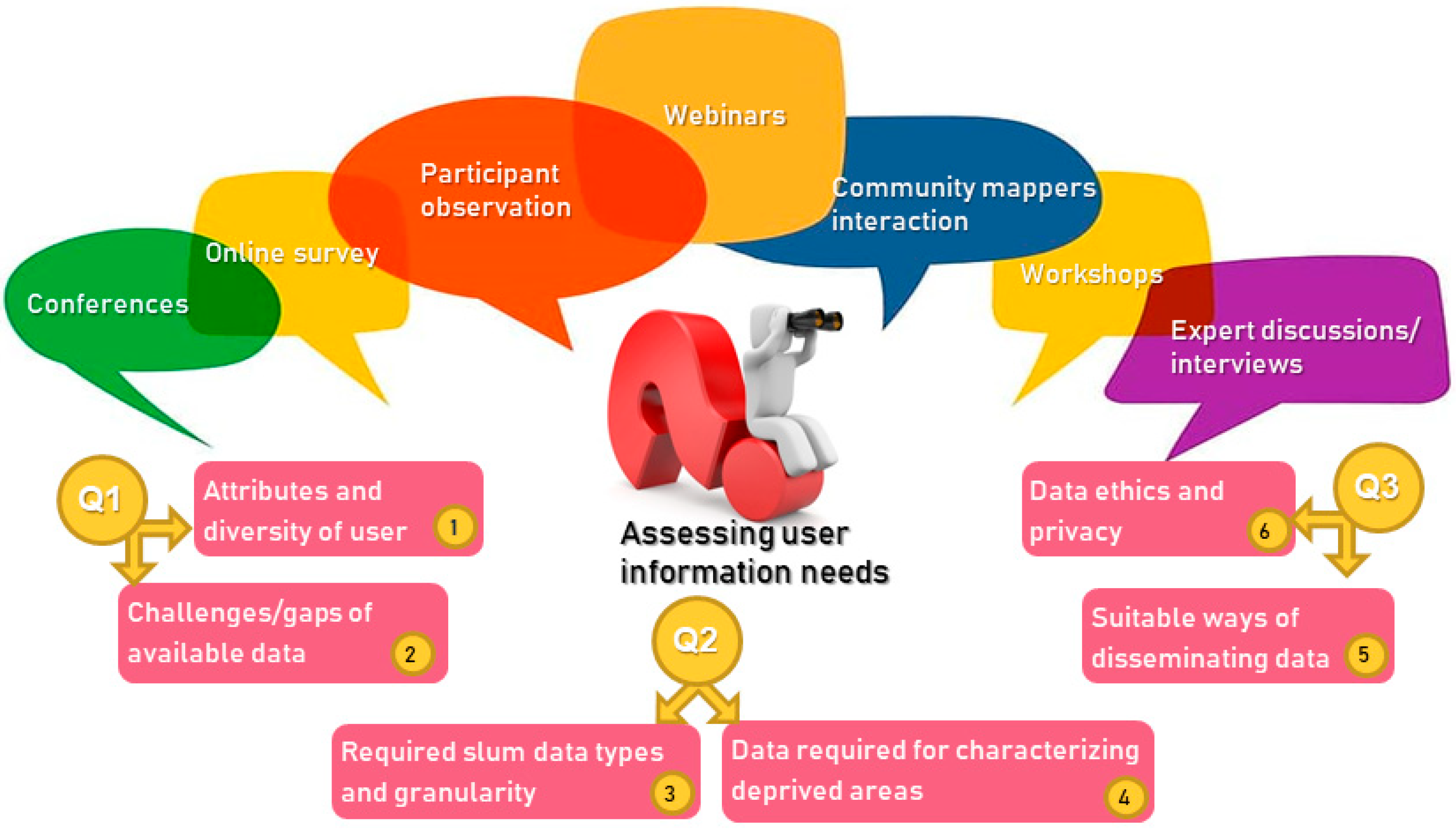
- Online survey of users (experts) working with deprived areas/slum-related spatial data (N = 112), conducted June–October 2020, using LimeSurvey (https://www.limesurvey.org, accessed 23 September 2021). The complete results of the online survey are available as Supplementary Material (LMIC focus).
- Participant observation (a qualitative data collection method) and summarizing discussion of several workshops linked with SLUMAP and the Integrated Deprived Area Mapping System (IDEAMAPS) [43]:
- -
- Human Planet Forum (Fall 2019) (global focus);
- -
- World Urban Forum (Spring 2020) (LMIC focus);
- -
- Several webinars (e.g., the IDEAMAPS Lounge webinar series) on deprived area mapping (throughout 2020) (LMIC focus);
- -
- Local IDEAMAPS workshops in Lagos and Accra (Fall 2020) (SSA focus);
- -
- Community mappers interaction Nairobi and Nigeria (Summer 2020–Spring 2021)—actively contributing to the establishment of a group (https://www.communitymappers.com, accessed 23 September 2021) and development of a community mapper training curriculum (Summer 2021) (SSA focus);
- -
- Several webinars of community-based (mapping) and discussions with CBOs (throughout 2020) (LMIC focus);
- Expert discussions and interviews with national and local planning authorities and national statistical offices (Spring 2019–Spring 2021) (LMIC focus).
2.3. Framing the Analysis of User Needs
- -
- What do diverse users identify as the major gaps in presently available spatial data on deprived areas (Q1)?
- -
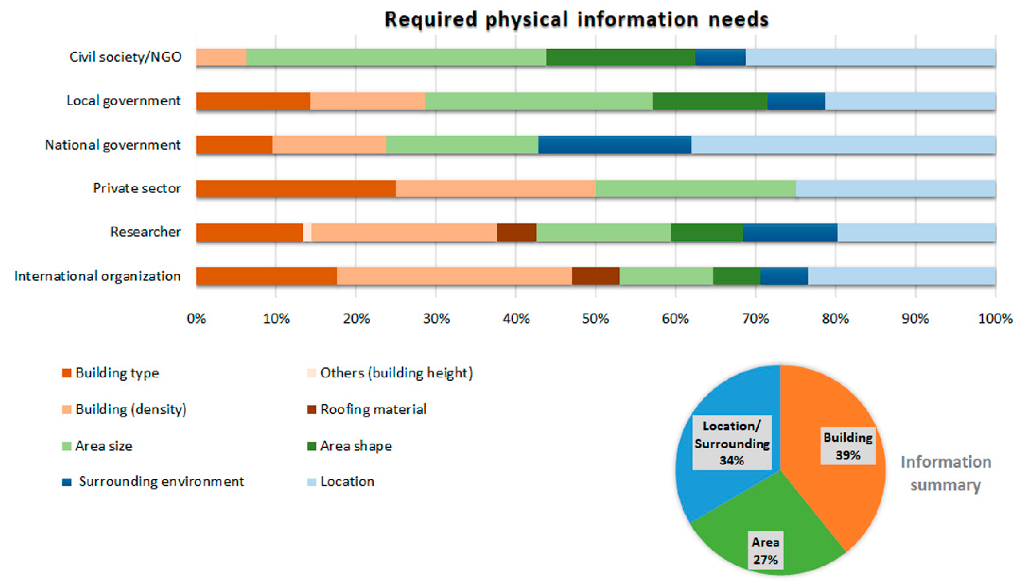
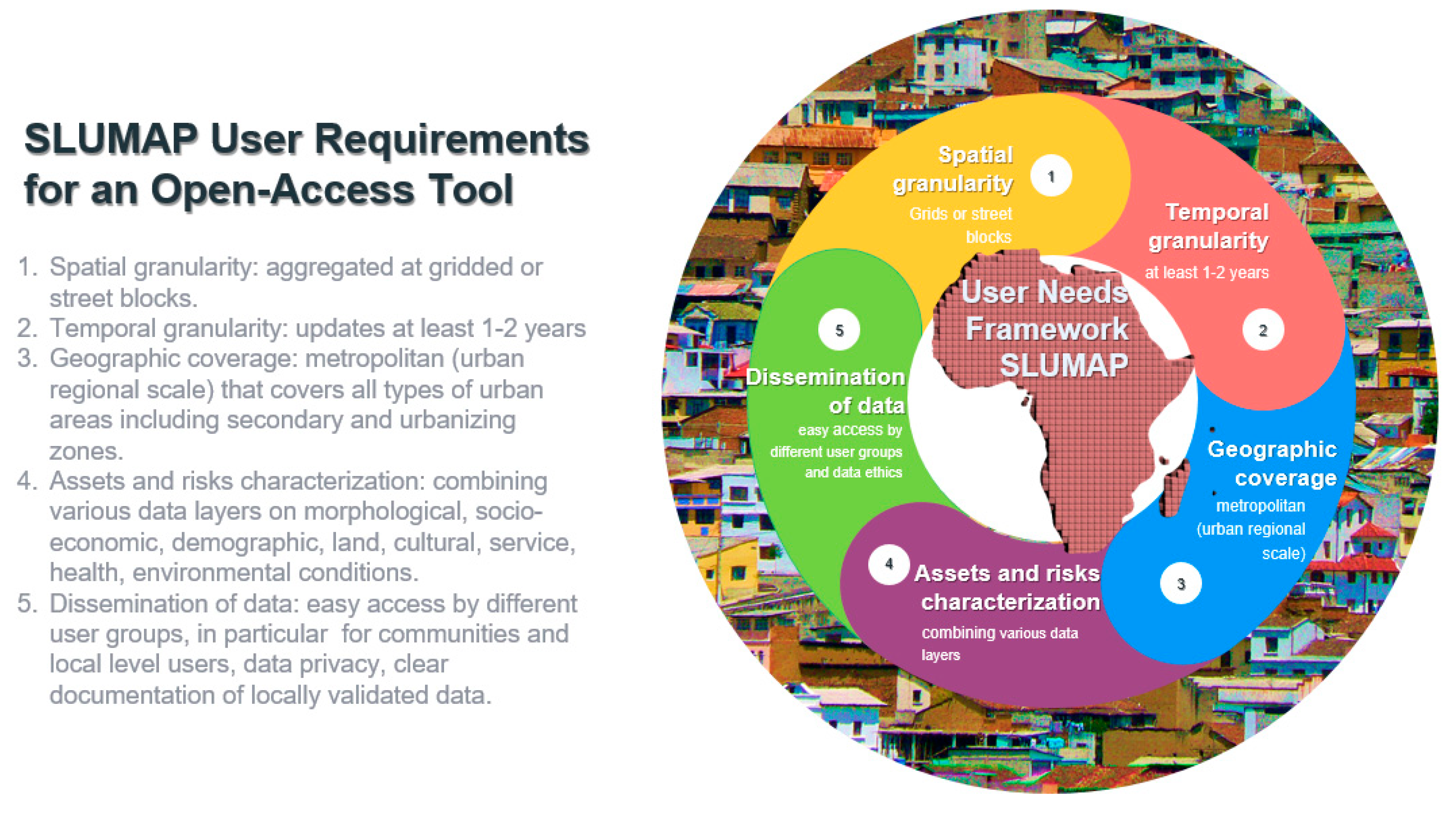
- What are the specific needs on characteristics and granularity of base data on deprived areas (Q2)?
- -
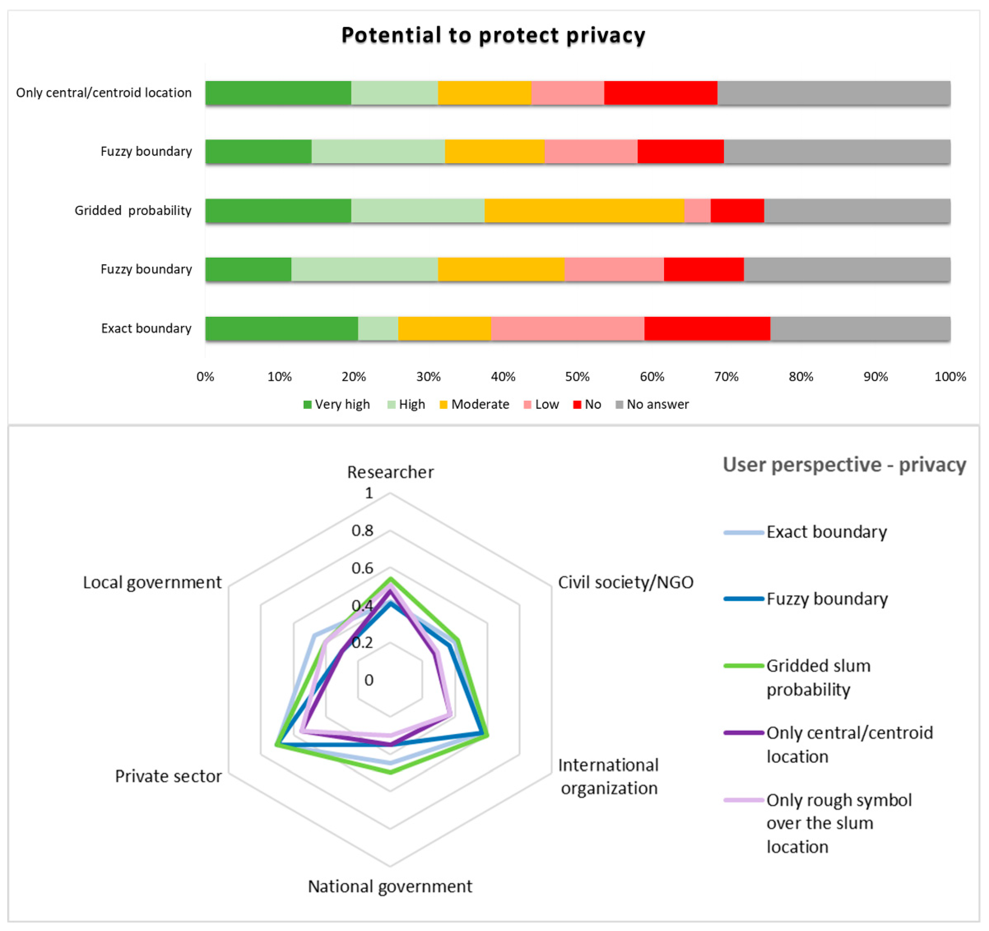
- How should spatial data on deprived urban areas be provided and disseminated to respond to privacy concerns (Q3)?
3. Results
3.1. Major Gaps in Available Spatial Data on Deprived Areas
3.1.1. Attributes and Diversity of User Groups
3.1.2. The Challenges and Gaps of Data on Deprived Areas
3.2. Characteristics of Deprived Areas and Required Granularity
3.2.1. Type, Spatial Extent, and Update Frequency of Required Data
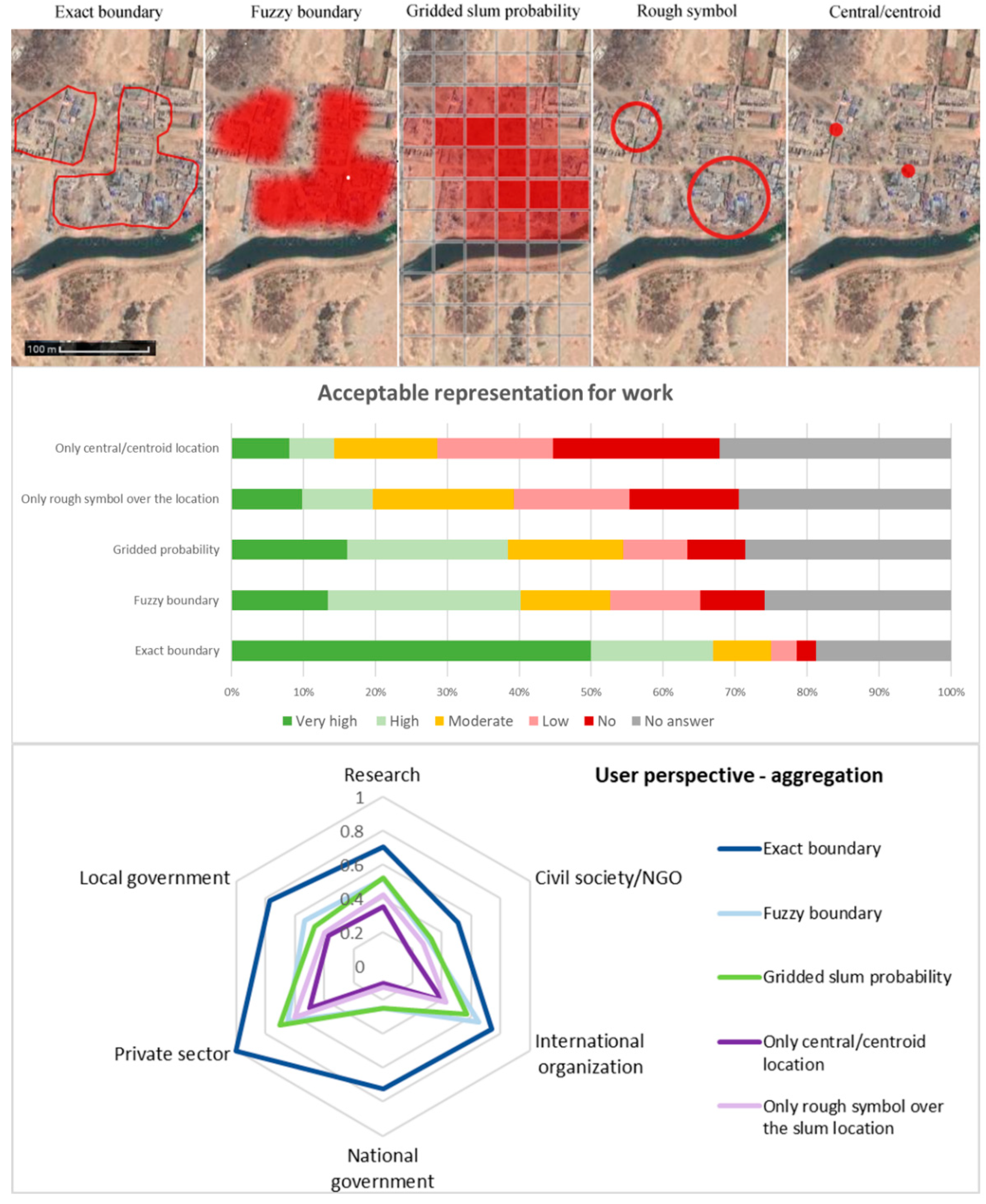
3.2.2. Characteristics of Deprived Areas Data
3.3. Dissemination and Privacy Concerns
3.3.1. Suitable Ways of Disseminating Deprived Area Data
3.3.2. Data Ethics and Privacy Concerns
4. Discussion
4.1. Identified Gaps in Spatial Information
4.2. Understanding User Information Needs
4.3. EO-Based Mapping in Response to User Needs
5. Conclusions
Supplementary Materials
Author Contributions
Funding
Institutional Review Board Statement
Informed Consent Statement
Data Availability Statement
Acknowledgments
Conflicts of Interest
References
- United Nations Statistics Division. The Sustainable Development Goals Report 2018. Available online: https://unstats.un.org/sdgs/report/2018/overview/ (accessed on 12 September 2020).
- UN Department of Economic and Social Affairs Population Division. World Population Prospects: The 2017 Revision; UN Department of Economic and Social Affairs Population Division: New York, NY, USA, 2017. [Google Scholar]
- Carr-Hill, R. Missing millions and measuring development progress. World Dev. 2013, 46, 30–44. [Google Scholar] [CrossRef]
- Brito, P.L.; Kuffer, M.; Koeva, M.; Pedrassoli, J.C.; Wang, J.; Costa, F.; Freitas, A.D.D. The Spatial Dimension of COVID-19: The Potential of Earth Observation Data in Support of Slum Communities with Evidence from Brazil. ISPRS Int. J. Geo-Inf. 2020, 9, 557. [Google Scholar] [CrossRef]
- Corburn, J.; Vlahov, D.; Mberu, B.; Riley, L.; Caiaffa, W.T.; Rashid, S.F.; Ko, A.; Patel, S.; Jukur, S.; Martínez-Herrera, E.; et al. Slum Health: Arresting COVID-19 and Improving Well-Being in Urban Informal Settlements. J. Urban Health 2020, 97, 348–357. [Google Scholar] [CrossRef] [Green Version]
- Smit, W. The challenge of COVID-19 in African cities: An urgent call for informal settlement upgrading. Cities Health 2020, 1–3. [Google Scholar] [CrossRef]
- Roy, D.; Bernal, D.; Lees, M. An exploratory factor analysis model for slum severity index in Mexico City. Urban Stud. 2020, 57, 789–805. [Google Scholar] [CrossRef] [Green Version]
- Kohli, D.; Sliuzas, R.V.; Kerle, N.; Stein, A. An ontology of slums for image-based classification. Comput. Environ. Urban Syst. 2012, 36, 154–163. [Google Scholar] [CrossRef]
- Williams, T.K.A.; Wei, T.; Zhu, X. Mapping Urban Slum Settlements Using Very High-Resolution Imagery and Land Boundary Data. IEEE J. Sel. Top. Appl. Earth Obs. Remote Sens. 2020, 13, 166–177. [Google Scholar] [CrossRef]
- Wurm, M.; Stark, T.; Zhu, X.X.; Weigand, M.; Taubenböck, H. Semantic segmentation of slums in satellite images using transfer learning on fully convolutional neural networks. ISPRS J. Photogramm. Remote Sens. 2019, 150, 59–69. [Google Scholar] [CrossRef]
- Zhu, Z.; Zhou, Y.; Seto, K.C.; Stokes, E.C.; Deng, C.; Pickett, S.T.A.; Taubenböck, H. Understanding an urbanizing planet: Strategic directions for remote sensing. Remote Sens. Environ. 2019, 228, 164–182. [Google Scholar] [CrossRef]
- SDI. Know Your City: Slum Dwellers Count. Available online: https://sdinet.org/2018/02/know-city-slum-dwellers-count/ (accessed on 23 September 2020).
- Gruebner, O.; Sachs, J.; Nockert, A.; Frings, M.; Khan, M.H.; Lakes, T.; Hostert, P. Mapping the slums of Dhaka from 2006 to 2010. Dataset Pap. Sci. 2014, 2014, 1–7. [Google Scholar] [CrossRef] [Green Version]
- Falco, E.; Zambrano-Verratti, J.; Kleinhans, R. Web-based participatory mapping in informal settlements: The slums of Caracas, Venezuela. Habitat Int. 2019, 94, 102038. [Google Scholar] [CrossRef]
- Kit, O.; Lüdeke, M. Automated detection of slum area change in Hyderabad, India using multitemporal satellite imagery. ISPRS J. Photogramm. Remote Sens. 2013, 83, 130–137. [Google Scholar]
- Mahabir, R.; Agouris, P.; Stefanidis, A.; Croitoru, A.; Crooks, A.T. Detecting and mapping slums using open data: A case study in Kenya. Int. J. Digit. Earth 2018, 13, 683–707. [Google Scholar] [CrossRef]
- Chi, G.; Fang, H.; Chatterjee, S.; Blumenstock, J.E. Micro-Estimates of Wealth for all Low-and Middle-Income Countries. arXiv 2021, arXiv:abs/2104.07761. [Google Scholar]
- University of Chicago. Million Neighborhoods Initiative. Available online: https://millionneighborhoods.org/ (accessed on 3 January 2020).
- Kuffer, M.; Wang, J.; Nagenborg, M.; Pfeffer, K.; Kohli, D.; Sliuzas, R.; Persello, C. The Scope of Earth-Observation to Improve the Consistency of the SDG Slum Indicator. ISPRS Int. J. Geo-Inf. 2018, 7, 428. [Google Scholar] [CrossRef] [Green Version]
- Wurm, M.; Taubenböck, H. Detecting social groups from space—Assessment of remote sensing-based mapped morphological slums using income data. Remote Sens. Lett. 2018, 9, 41–50. [Google Scholar] [CrossRef]
- Duque, J.C.; Patino, J.E.; Betancourt, A. Exploring the Potential of Machine Learning for Automatic Slum Identification from VHR Imagery. Remote Sens. 2017, 9, 895. [Google Scholar] [CrossRef] [Green Version]
- Taubenböck, H.; Kraff, N.J.; Wurm, M. The morphology of the arrival city—A global categorization based on literature surveys and remotely sensed data. Appl. Geogr. 2018, 92, 150–167. [Google Scholar] [CrossRef]
- Persello, C.; Stein, A. Deep Fully Convolutional Networks for the Detection of Informal Settlements in VHR Images. IEEE Geosci. Remote Sens. Lett. 2017, 14, 2325–2329. [Google Scholar] [CrossRef]
- Kuffer, M.; Pfeffer, K.; Sliuzas, R. Slums from space—15 years of slum mapping using remote sensing. Remote Sens. 2016, 8, 455. [Google Scholar] [CrossRef] [Green Version]
- Engstrom, R.; Sandborn, A.; Yu, Q.; Burgdorfer, J.; Stow, D.A.; Weeks, J.; Graesser, J. Mapping slums using spatial features in Accra, Ghana. In Joint Urban Remote Sensing Event (JURSE); IEEE: Lausanne, Switzerland, 2015; pp. 1–4. [Google Scholar]
- Verma, D.; Jana, A.; Ramamritham, K. Transfer learning approach to map urban slums using high and medium resolution satellite imagery. Habitat Int. 2019, 88, 101981. [Google Scholar] [CrossRef]
- Kuffer, M.; Thomson, D.R.; Boo, G.; Mahabir, R.; Grippa, T.; Vanhuysse, S.; Engstrom, R.; Ndugwa, R.; Makau, J.; Darin, E.; et al. The Role of Earth Observation in an Integrated Deprived Area Mapping “System” for Low-to-Middle Income Countries. Remote Sens. 2020, 12, 982. [Google Scholar] [CrossRef] [Green Version]
- Thomson, D.R.; Kuffer, M.; Boo, G.; Hati, B.; Grippa, T.; Elsey, H.; Linard, C.; Mahabir, R.; Kyobutungi, C.; Maviti, J.; et al. Need for an Integrated Deprived Area “Slum” Mapping System (IDEAMAPS) in Low-and Middle-Income Countries (LMICs). Soc. Sci. 2020, 9, 80. [Google Scholar] [CrossRef]
- de Albuquerque, J.P.; Yeboah, G.; Pitidis, V.; Ulbrich, P. In Towards a participatory methodology for community data generation to analyse urban health inequalities: A multi-country case study. In Proceedings of the 52nd Hawaii International Conference on System Sciences, Grand Wailea, HI, USA, 8–11 January 2019; pp. 3925–3926. [Google Scholar]
- Ezeh, A.; Oyebode, O.; Satterthwaite, D.; Chen, Y.-F.; Ndugwa, R.; Sartori, J.; Mberu, B.; Melendez-Torres, G.J.; Haregu, T.; Watson, S.I.; et al. The history, geography, and sociology of slums and the health problems of people who live in slums. Lancet 2017, 389, 547–558. [Google Scholar] [CrossRef]
- Lilford, R.J.; Oyebode, O.; Satterthwaite, D.; Melendez-Torres, G.J.; Chen, Y.-F.; Mberu, B.; Watson, S.I.; Sartori, J.; Ndugwa, R.; Caiaffa, W.; et al. Improving the health and welfare of people who live in slums. Lancet 2017, 389, 559–570. [Google Scholar] [CrossRef]
- Wardrop, N.A.; Jochem, W.C.; Bird, T.J.; Chamberlain, H.R.; Clarke, D.; Kerr, D.; Bengtsson, L.; Juran, S.; Seaman, V.; Tatem, A.J. Spatially disaggregated population estimates in the absence of national population and housing census data. Proc. Natl. Acad. Sci. USA 2018, 115, 3529. [Google Scholar] [CrossRef] [PubMed] [Green Version]
- Wang, S.; So, E.; Smith, P. Detecting tents to estimate the displaced populations for post-disaster relief using high resolution satellite imagery. Int. J. Appl. Earth Obs. Geoinf. 2015, 36, 87–93. [Google Scholar] [CrossRef]
- de Sherbinin, A.; Bukvic, A.; Rohat, G.; Gall, M.; McCusker, B.; Preston, B.; Apotsos, A.; Fish, C.; Kienberger, S.; Muhonda, P.; et al. Climate vulnerability mapping: A systematic review and future prospects. WIREs Clim. Chang. 2019, 10, e600. [Google Scholar] [CrossRef]
- Abras, C.; Maloney-Krichmar, D.; Preece, J. User-centered design. Bainbridge, W. Encyclopedia of Human-Computer Interaction. Thousand Oaks Sage Publ. 2004, 37, 445–456. [Google Scholar]
- Hewitt, R.J.; Macleod, C.J.A. What Do Users Really Need? Participatory Development of Decision Support Tools for Environmental Management Based on Outcomes. Environments 2017, 4, 88. [Google Scholar] [CrossRef] [Green Version]
- Wong, K.; Ellul, C. User requirements gathering for 3D geographic information in the United Kingdom. ISPRS Ann. Photogramm. Remote Sens. Spat. Inf. Sci. 2017, 4, 125–132. [Google Scholar] [CrossRef] [Green Version]
- Whitworth, A. (Ed.) Towards a Spatial Social Policy. In Bridging the Gap between Geography and Social Policy, 1st ed.; Bristol University Press: Bristol, UK, 2019. [Google Scholar]
- Soman, S.; Beukes, A.; Nederhood, C.; Marchio, N.; Bettencourt, L.M.A. Worldwide Detection of Informal Settlements via Topological Analysis of Crowdsourced Digital Maps. ISPRS Int. J. Geo-Inf. 2020, 9, 685. [Google Scholar] [CrossRef]
- Novack, T.; Kux, H.; Feitosa, R.Q.; Costa, G.A.O.P. A knowledge-based, transferable approach for block-based urban land-use classification. Int. J. Remote Sens. 2014, 35, 4739–4757. [Google Scholar] [CrossRef]
- Brhel, M.; Meth, H.; Maedche, A.; Werder, K. Exploring principles of user-centered agile software development: A literature review. Inf. Softw. Technol. 2015, 61, 163–181. [Google Scholar] [CrossRef]
- Brito, P.L. Community Mapping Online Event 2021. Federal University of Bahia, Brazil. 2021. Available online: https://www.youtube.com/playlist?list=PL63qkxAMZRh-PyM64b64QqeiQKlSQbJ_69Br (accessed on 1 June 2021).
- Kawulich, B.B. Participant observation as a data collection method. Forum Qual. Soz. Forum Qual. Soc. Res. 2005, 6, 43. [Google Scholar]
- Quiroz Canlas, F.; Nair, S.; Doss, A.N. Mentimeter App in Computer Science Courses: Integration Model and Students’ Reception. In Proceedings of the 2020 12th International Conference on Education Technology and Computers, London, UK, 23–26 October 2020; Association for Computing Machinery: New York, NY, USA, 2020; pp. 1–5. [Google Scholar]
- UN-Habitat. Slums Almanac 2015-16. Tracking Improvement in the Lives of Slum Dwellers; UN-Habitat: Nairobi, Kenya, 2016. [Google Scholar]
- IdeaMapsNetwork. COVID-19 in African Cities: Impacts, Responses and Policies Recommendations. Available online: https://ideamapsnetwork.org/covid-19-in-african-cities-impacts-responses-and-policies-recommendations/ (accessed on 15 November 2020).
- Justice & Empowerment Initiatives—Nigeria (JEI). Impact of Covid19 on Lagos Informal Settlements & Vulnerable Urban Poor Populations; Lagos, Nigeria. Available online: https://static1.squarespace.com/static/535d0435e4b0586b1fc64b54/t/5ee9db41f7dd700403e136f3/1592384435834/C19+Survey+Lagos+Findings+Report+%28June+2020%29_FINAL.pdf (accessed on 15 November 2020).
- IdeaMapsNetwork. Community Mappers Identify and Respond to Needs in Informal Settlements during COVID-19. Available online: https://ideamapsnetwork.org/community-mappers-survey-informal-settlements-during-covid-19/ (accessed on 15 November 2020).
- Wanjiru, N. Community Voices #1: Waste Management Solutions; Vice Versa. Available online: https://viceversaonline.nl/2021/09/10/community-voices-1-waste-management-solutions/ (accessed on 10 September 2021).
- Leyk, S.; Gaughan, A.E.; Adamo, S.B.; de Sherbinin, A.; Balk, D.; Freire, S.; Rose, A.; Stevens, F.R.; Blankespoor, B.; Frye, C.; et al. The spatial allocation of population: A review of large-scale gridded population data products and their fitness for use. Earth Syst. Sci. Data 2019, 11, 1385–1409. [Google Scholar] [CrossRef] [Green Version]
- Badmos, O.S.; Rienow, A.; Callo-Concha, D.; Greve, K.; Jürgens, C. Simulating slum growth in Lagos: An integration of rule based and empirical based model. Comput. Environ. Urban Syst. 2019, 77, 101369. [Google Scholar] [CrossRef]
- Grippa, T.; Georganos, S.; Zarougui, S.; Bognounou, P.; Diboulo, E.; Forget, Y.; Lennert, M.; Vanhuysse, S.; Mboga, N.; Wolff, E. Mapping Urban Land Use at Street Block Level Using OpenStreetMap, Remote Sensing Data, and Spatial Metrics. ISPRS Int. J. Geo-Inf. 2018, 7, 246. [Google Scholar] [CrossRef] [Green Version]
- Dubovyk, O.; Sliuzas, R.; Flacke, J. Spatio-temporal modelling of informal settlement development in Sancaktepe district, Istanbul, Turkey. ISPRS J. Photogramm. Remote Sens. 2011, 66, 235–246. [Google Scholar] [CrossRef]
- Arribas-Bel, D.; Patino, J.E.; Duque, J.C. Remote sensing-based measurement of living environment deprivation: Improving classical approaches with machine learning. PLoS ONE 2017, 12, e0176684. [Google Scholar]
- Baud, I.; Sridharan, N.; Pfeffer, K. Mapping urban poverty for local governance in an Indian mega-city: The case of Delhi. Urban Stud. 2008, 45, 1385–1412. [Google Scholar] [CrossRef]




| Open Platform | Author/Institution | Geographic Coverage (GC) | GC Name | Year | Updated | Referenced Work | Source | Pixel Size km | Spatial Data | Data Description | Other Data | Other Data Description | Links |
|---|---|---|---|---|---|---|---|---|---|---|---|---|---|
| Mapping Urban Informality | Jess Kersey / UC Berkley | City scale | Dhaka | 2006, 2010 | No | Gruebner et al. [13] | EO and Census | NA | geojson | Slum Boundary | 1 indicator *1 | *1: ward name; *2: population and administrative data; *3: administrative data; *4: data on health, facilities, infrastructure etc.; *5: location, type and description of faclities | Links: Mapping Urban Informality: http://www.mappingurbaninformality.com/; RWI: https://data.humdata.org/dataset/relative-wealth-index; Mapillary: https://www.mapillary.com/, 23 September 2021; HOT: https://data.humdata.org/organization/hot; https://data.unhabitat.org/pages/slum-data-surveys, 23 September 2021 |
| City scale | Caracas | 2019 | No | Falco et al. [14] | Survey | NA | geojson | Slum Boundary | 12 indicators *2 | ||||
| City scale | Rio de Janeiro | 2014 | 2019 | Instituto Pereira Passos | Census | NA | geojson | Slum Boundary | 18 indicators *3 | ||||
| City scale | Mumbai | 2017 | No | Municipality Mumbai planning | Census AND Survey | NA | geojson | Slum Boundary | Yes | ||||
| City scale | Hyderabad | 2014 | No | Kit & Lüdeke [15] | EO | 0.6 | geojson | Slum Boundary | No | ||||
| City scale | Buenos Aires | 2018 | No | Dymaxion Labs | EO | NA | geojson | Slum Boundary | No | ||||
| City scale | Guatemala | 2018 | No | Dymaxion Labs | EO | NA | geojson | Slum Boundary | No | ||||
| City scale | Tegucigalpa | 2018 | No | Dymaxion Labs | EO | NA | geojson | Slum Boundary | No | ||||
| City scale | Asunción | 2018 | No | Dymaxion Labs | EO | NA | geojson | Slum Boundary | No | ||||
| City scale | Lima | 2019 | No | Dymaxion Labs | EO | NA | geojson | Slum Boundary | No | ||||
| City scale | Montevideo | 2018 | No | Dymaxion Labs | EO | NA | geojson | Slum Boundary | No | ||||
| City scale | Nairobi | 2018 | No | Mahabir et al. [16] | EO | NA | geojson | Slum Boundary | No | ||||
| City scale | Mombasa | 2018 | No | Mahabir et al. [16] | EO | NA | geojson | Slum Boundary | No | ||||
| City scale | Port-au-Prince | 2020 | No | Jess Kersey | NA | NA | geojson | Slum Boundary | No | ||||
| The relative wealth Index (RWI) | UC Berkeley Center and Facebook’s Data for Good | Worldwide | 92 LMIC Countries | 2021 | No | Chi et al. [17] | EO and topographic maps and mobile network and connectivity data | 2.4 | csv | RWI gridded | No | ||
| Mapillary | Mapillary | Worldwide | All Countries | 2013 | Up-to-date | No | Street View Images | NA | jpg | NA | No | ||
| Humanitarian Open Street Map (HOT) | Humanitarian Open Street Maps | Worldwide | 246 Countries | 2013 | Up-to-date | No | Humanitarian community mapping | NA | Csv Shp Garmin IMG Geopackage KML | polygons | 36 tags *4 | ||
| Informal settlements’ vulnerability mapping | UN-Habitat | Kenya city/settlement scale | Kisumu and 3 settlements in Nairobi | 2020 | No | UN-Habitat | Survey | NA | shp KML Xls Geodatabase | points | Facility types *5 |
Publisher’s Note: MDPI stays neutral with regard to jurisdictional claims in published maps and institutional affiliations. |
© 2021 by the authors. Licensee MDPI, Basel, Switzerland. This article is an open access article distributed under the terms and conditions of the Creative Commons Attribution (CC BY) license (https://creativecommons.org/licenses/by/4.0/).
Share and Cite
Kuffer, M.; Wang, J.; Thomson, D.R.; Georganos, S.; Abascal, A.; Owusu, M.; Vanhuysse, S. Spatial Information Gaps on Deprived Urban Areas (Slums) in Low-and-Middle-Income-Countries: A User-Centered Approach. Urban Sci. 2021, 5, 72. https://doi.org/10.3390/urbansci5040072
Kuffer M, Wang J, Thomson DR, Georganos S, Abascal A, Owusu M, Vanhuysse S. Spatial Information Gaps on Deprived Urban Areas (Slums) in Low-and-Middle-Income-Countries: A User-Centered Approach. Urban Science. 2021; 5(4):72. https://doi.org/10.3390/urbansci5040072
Chicago/Turabian StyleKuffer, Monika, Jon Wang, Dana R. Thomson, Stefanos Georganos, Angela Abascal, Maxwell Owusu, and Sabine Vanhuysse. 2021. "Spatial Information Gaps on Deprived Urban Areas (Slums) in Low-and-Middle-Income-Countries: A User-Centered Approach" Urban Science 5, no. 4: 72. https://doi.org/10.3390/urbansci5040072
APA StyleKuffer, M., Wang, J., Thomson, D. R., Georganos, S., Abascal, A., Owusu, M., & Vanhuysse, S. (2021). Spatial Information Gaps on Deprived Urban Areas (Slums) in Low-and-Middle-Income-Countries: A User-Centered Approach. Urban Science, 5(4), 72. https://doi.org/10.3390/urbansci5040072


