1. Introduction
According to the Universal Declaration of Human Rights mobility is a human right. In this article, we write about connectivity as a major aspect of mobility. Similarly, we depart from the premise that connectivity is a human right and that cities have the responsibility to institute urban policies that are equitable. Many major cities in the United States have an economic division within their boundaries where residents have limited access to infrastructure, places or destinations that assist with basic needs, recreation, and/or entertainment. In our area of study, the west side of Salt Lake City, disparity is apparent. When thinking about the west side, the public generally focuses on ethnic diversity, lower incomes, and the perception of crime.
When an area struggles with lower incomes, families are putting a higher percentage of their income toward housing and transportation expenses than people with higher incomes. The idea of connectivity in a transportation network as it relates to our human right is providing residents within a neighborhood access to a wide variety of destinations through the use of several modes of transportation making outings convenient. Public and active transportation may be viable solutions for cost savings and convenience for those who live below the average median income (AMI). The purpose of this article is to evaluate the connectivity between two dissimilar purpose corridors, from a destination perspective, in order to increase the utilization of the Jordan River Parkway Trail (JRPT) as well as the North Temple corridor for active transportation by west side residents.
Not many people are aware of the opportunity Salt Lake City has to create a major multi-modal transportation network. The city has the ability to link several types of transportation in one strategic connection. Specifically, this is where the JRPT and North Temple meet. Strengthening the connection of these two corridors could help decrease the dependency on automobile usage among west side residents, provide transportation solutions through active transportation, and increase overall city and regional connectivity.
The current study used 299 resident surveys to allow discussion of detailed environmental factors that may influence active transport between two community assets—the JRPT (a recreational trail) and North Temple (a commercial transit-oriented development (TOD) corridor). Applications of social research methods descriptive statistics are presented for the survey while quotes from focus groups are used to understand perceived connectivity. The case study presented here represent a unique connection between a trail and a TOD corridor. The trail runs north and south of west side neighborhoods and the TOD corridor runs east to west. The study area is 3 sq. miles and has a population of about 19,000 people with a population density of 6663 people per square mile. We hope this study broads the field of connectivity in the urban social science and using descriptive survey research.
This article is organized in four sections. First, in the literature review we will discuss the various elements that affects connectivity in a transportation network. Second, different aspects of the west side of Salt Lake City will be explored in order to gain a clear picture of the opportunities and challenges the area faces regarding connectivity in the transportation network as it relates to the JRPT and North Temple. Third, the methods section describes how the survey and focus groups were conducted. Finally, by applying the knowledge gained during the research, data analysis, and community feedback to these issues, the discussion and conclusion identifies policies for increasing area connectivity in a transportation network characterized by linkages between regional trails and transit-oriented area corridors.
2. Literature Review
This literature review is dedicated to understanding the factors that might increase active transportation in a network. The most recognized and commonly used metrics are the 5 D’s—which are design, destinations, density, diversity and distance [
1]. Good design can be a conduit for the facilitation of several transportation modes because it can make destinations more accessible via foot or bike in a transportation network through the provision of amenities such as shade trees, public plazas, etc. [
2]. Compact or dense neighborhoods with more intersections can degenerate vehicle trips and encourage non-motorized travel in several ways. One, by bringing origins and destinations closer together in a network, there are more opportunities for leaving one’s car at home and walking or cycling [
1,
3]. Two, when destinations become closer within a network, they become convenient. It may be argued that convenience (many times understood as distance or destination accessibility) is part of what it means to be truly connected to a larger transportation network. Djurhuss supports this idea by arguing that more convenience is associated with active commuting [
4]. When destinations become convenient, people may be more apt to substitute driving with another form of transportation.
In cities, density is a means to address and solve for convenience when moving within a transportation network. Higher densities, diverse land uses, and pedestrian-friendly designs, must co-exist to a certain degree if meaningful transportation network benefits are to accrue [
2,
5]. Having nice sidewalks, attractive landscaping, and other pedestrian amenities in a low-density, residential-only neighborhood lacking diversity is unlikely to prompt many residents to walk or bike [
2,
5,
6]. This leads us to another principle of designing transportation networks. Among network design variables, intersection density more strongly sways the decision to walk or bike than does street connectivity [
7,
8,
9]. Although street connectivity is important, general connectivity is related to shorter distances in a network this is because a direct or a short path to a destination signifies higher connectivity [
8]. Walkability may be limited even if connectivity is excellent when blocks are long [
1].
Nonetheless, density, generally speaking, increases the probability of choosing walking as a mode of transportation. Density is the key factor in setting expectations regarding pedestrian volume [
10]. However, an aspect of walking that should be accounted for is time. Frequency of walking logically depends on the time it takes to access destinations relative to other modes and is highly sensitive to proximity (land use density and mix) and route directness or street connectivity [
11]. Travel time differentials between car and bus can influence mode choice between origin–destination pairs. In other words, a dense, mixed-use, pedestrian-friendly destination is more likely to induce transit riding than a sprawling, single-use, auto-oriented suburban one [
2]. This relates back to the convenience idea. How long it takes is important. However, if a place has access to more destinations in a given area, individuals may be more likely to use modes of transportation that do not involve a motorized vehicle. One of the challenges for future transport planning is to create solutions that enable time-competing multimodal trips for those with longer commute distances, thereby incorporating active transportation into otherwise car dominant commuting transportation networks [
4].
Areas with a lower density of arterial roads or highways have a higher likelihood of cycling [
12] Simple stated preference studies usually find that people prefer bike paths and lanes or indicate that having such infrastructure would encourage them to bicycle more [
7,
13]. Bicycle boulevards are usually low-traffic, minor streets, usually running parallel to a major road, that use traffic calming features that are design to give priority to bicycles over motor vehicles. Off-road trails may be another solution. Concerned bicyclists highly value multi-use trails, but not necessarily in terms of connectivity to destinations, but rather in terms of recreational bicycling [
13].
Destinations play a big role in connectivity and choosing active transportation. Among the 5 D’s the destination variable is most strongly associated with vehicle miles travelled (VMT) [
1]. To get people out of their cars, accounting for accessibility along with density in relation to destinations is necessary. The outcomes for the density measures reveal the importance of both easy access to public transportation and to different transport modes and routes that enable more destinations to be reached along a transportation network [
14]. Having a healthy mix of destinations within the same place is helpful for people to choose other modes of transportation. Specially, transit-oriented development (TOD) encourages dense, mixed-use communities that, by design, invite residents, workers, and shoppers to drive their cars less [
6] Nonetheless, low-income neighborhoods are likely to have fewer of these options available [
15]. In low-income neighborhoods, like the west side another element that might detract people from engaging in active transportation is perceived crime [
16,
17,
18]. But in many low-income neighborhoods light rail is being develop along TOD corridors, which might increase eyes on the street. Having access to more transport mode choices like light rail within walking or cycling distance is known to have a positive effect on being an active commuter [
4]. This research seeks to identify connectivity gaps in a low-income neighborhood a topic that is under studied along with equity issues and social exclusion [
19,
20,
21].
This article employs the 5D’s, design, destination, density, diversity, and distance to understand how the JRPT and the North Temple TOD corridor—two mayor community assets or nodes—relate to each other, are linked, bridged or connected together to form a larger active transportation network. We surveyed users to understand how and why they use each node (the JRPT and the North Temple corridor) in order to evaluate: (1) how these nodes already connect and, (2) how to improve the way they are connected. In other words, we are trying to understand how the 5D’s affect connectivity which ultimately allows system integration by bonding trails with transit-oriented corridors. By using surveys, we sought to understand from participants what they see as missing in each of these node pairs and how they think that they should be better connected. Ultimately, we hope to offer policy solutions that can improve large-scale network design when these two types of nodes are linked.
3. Site Background
In order to accurately analyze increasing the utilization of the JRPT by active transportation users through destinations along North Temple, understanding Salt Lake City’s west side is essential. First, knowing what each of the corridors are used for can help us determine user purpose. Second, knowing the types of destinations that are currently found on the west side can help determine whether transportation purpose and destination correspond.
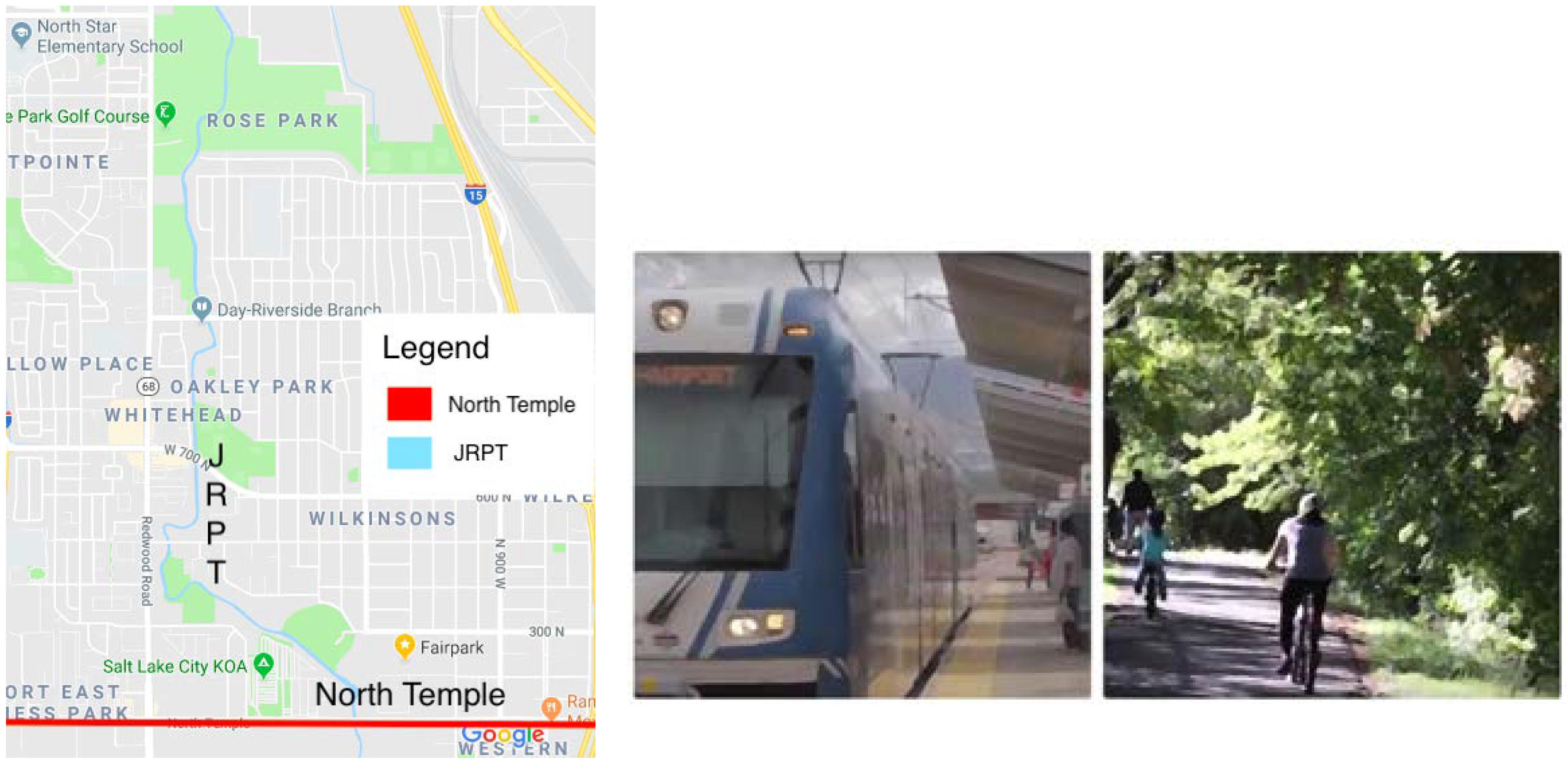
As mentioned earlier, Salt Lake City has two main transportation corridors on the west side. Each corridor has its own unique purpose. The Salt Lake City bike map indicates that the JRPT is an off-road trail and that North Temple is a corridor with low motor vehicle speed and volume. Between the two corridors, residents have a variety of transportation options, walking, biking, automobile, buses, and light rail (see
Figure 1). Where the two corridors overlap is through walking and biking which are forms of active transportation.
3.1. Jordan River Parkway Trail (JRPT)
The JRPT follows the path of one of nature’s amenities, the Jordan River, from Utah Lake to the south up to the Great Salt Lake in the north. Over the course of 2007 and 2008, Envision Utah facilitated the development of a regional visioning document for the JRPT [
22]. Ideas generated in the vision came from residents, technical experts, and planning officials. The vision for the corridor provides a blueprint for turning a neglected river into a defining regional amenity. This vision is intended to capture the collective imagination of residents and to build an appreciation for the important environmental, social, and economic role the river has played and can play in our region [
22].
One of the greatest benefits of the JRPT is that it is part of a greater regional trail system which connects several cities and counties through an active transportation corridor. On the south end, the JRPT has the potential to connect with the Murdock Canal Trail in Utah County which connects easily to the Provo Canyon Trail and other parts of Southern Utah County. On the north end of the JRPT, a section of the JRPT is called the Chevron Mile Trail. It connects the JRPT to the Legacy Parkway Trail in Davis County and other parts of northern Utah.
The total length of the JRPT is 45 miles. It connects people to a variety of destinations, including urban fishing ponds, cultural centers, demonstration gardens, shopping areas, and parks [
22]. Access to the JRPT can be found in residential neighborhoods and at major street intersections around the Jordan River. The trail system allows for multiple uses. It was specifically designed to accommodate all modes of transportation except motorized vehicles. The JRPT includes a paved trail, an equestrian trail, several connecting neighborhood trails, and will ultimately also include a water trail for boaters [
22].
People are encouraged to use the path by foot, bike, horse, canoe, and kayak. Currently, it is heavily used for recreational purposes. People of all ages and abilities are able to use this incredible trail system. For these reasons, this corridor is conducive to multiple types of active transportation [
1].
A commission has been instituted to help implement concepts from the visioning document. The commission comprises a mix of governmental and non-governmental members working together to enhance, preserve, protect, and responsibly develop the river corridor. Current membership includes 14 cities, three counties, six districts, and two state agencies [
22]. All these members are dedicated to the success of the JRPT as an amenity to the community.
The JRPT provides a great opportunity for use in Salt Lake City’s west side. It has the potential to attract people from a wide variety of places and from distances further away. It provides a way for people to connect to downtown Salt Lake City through active transportation instead of by car, strengthening connectivity.
3.2. North Temple
North Temple has been a main road in Salt Lake City from the very beginning of the city’s history. It is named because of its point of connection to the Mormon Temple, which belongs to the Church of Jesus Christ of Latter-day Saints. The road runs directly north of the temple heading east and west through the Salt Lake Valley. Today, it is the main thoroughfare that connects the east side of Salt Lake City to the west. This road is extremely important because it easily transitions through the two major transit barriers that have cut the city in half. North Temple goes under the Interstate 15 freeway and over the heavy rail lines.
Another benefit of North Temple is that it goes directly to the airport. This is a huge benefit today and for the future because the airport is expanding. It has reached its capacity and needs to grow in order to accommodate larger quantities of travelers. This will significantly increase the number of North Temple users. Because there will be more people or, in other words, a higher density, the thoroughfare may be able to accommodate and support increased development.
North Temple is one of the few main roads in Salt Lake City that boasts light rail. This main road also has several bus stops for different routes and accommodates active transportation options, such as walking and biking. North Temple is a prime road for increasing area connectivity because it promotes alternative modes of transportation due to the variety of options available. Although Salt Lake City does not have the population density to support a public transit system that is expansive and reliable, the city can take steps to reduce car usage and plan for more sustainable transit options.
As mentioned, economic disparity between the east and west sides of Salt Lake City is quite evident. As such, North Temple serves as the lifeline for people who live on the west side. Shopping, dining, and entertainment options are all found on this road. It is where development in the community will start to happen. This can already start to be seen. Currently, the corridor is seeing a lot of development activity. Many multi-family housing units are being built toward the west end of North Temple.
Urban sprawl, growing individualism, social equity, and personal health issues, to name a few, have had some bearing on the dependency of automobiles. However, these multi-family units are starting to increasing connectivity and decreasing car usage. In many ways, transit can act as a cure for the visible inequality on the west side. Providing options for transit or planning for efficient transit systems in the future can help connect residents, neighborhoods, and communities that are segregated, such as Salt Lake City’s west side.
3.3. Connectivity between the JRPT and North Temple
Exploring the current zoning might provide a way to understand connectivity between the JRPT and North Temple. The last couple of decades have brought about a paradigm shift regarding land-use planning. Focus is changing from a low density and segregated use development pattern to a higher density and mixed-use development pattern. This change in ideas is beneficial for many reasons, and specific to this paper it can help with connectivity and support the use of alternate transportation modes, especially in areas prone to inequality.
North Temple has commercial development, which is appropriate for this corridor. The land along North Temple has a variety of transit station area (TSA) zoning designations, meaning that the land in the area is meant for uses conducive to a transit station. Between Interstate 15 and the JRPT, zoning is designated as an urban neighborhood transit station. According to the code, this means that potential developments will generally be for infill and should match the surrounding neighborhood.
The zoning code also designates portions of the TSA zones as a Special Purpose (SP) transit station. This designation acknowledges existing land uses however, it promotes development of retail space and restaurants. Other portions of North Temple, typically west of the JRPT, indicate that the land is zoned for Mixed Use Employment Center (MUEC) which supports a mixture of uses in areas that have “campus-style” development. That designation refers to areas planned for a large concentration of jobs. The MUEC areas are typically found where several Utah state government offices, such as the Department of Agriculture, Health and Human Service, are clustered on the north side of the street.
Zoning along the JRPT is varied. To the south of North Temple, most of the land abutting the JRPT has an M-1 zoning designation. In these areas, light industrial is the appropriate land use. There are a couple of other land use designations on the south end. There is an area designated for business park and one for institution purposes. Where North Temple and the JRPT intersect, the land uses are zoned as TSA-SP and commercial. To the north of North Temple are two other zones, another area for MUEC and one for public lands. The public land designation coincides with the land that the Utah State Fair Park sits upon.
One of the ways zoning can help with connectivity is physically and visually. To be physically connected, a space has to be well-connected in terms of paths and circulation and free from physical barriers, such as fences or walls. To be visually connected, a location needs to be seen from certain points [
13]. North Temple has good connectivity when it comes to visual and physical perspectives. The JRPT could use improvements in this aspect. The current situation is that the two corridors do not connect well physically, visually, or with end trip destinations.
4. Methods
The University of Utah offered a studio course which explored the connectivity between North Temple and the Jordan River Parkway. The class gathered neighborhood feedback through a survey that contained 23 questions. The methodology employed to develop the questions and the method was thought Participatory Action Research. The initial idea for questions came from a community partners—the Jordan River Commission, the Utah Transportation Authority, University Neighborhood Partners, NeighborWorks, and several community councils. Students took these initial ideas and formulated a number of questions, totaling about 150 potential questions. A group of students then narrowed those questions, which they shared with community partners. Community partners further refined the questions and went back and forward with the team of students in charge of producing a final survey draft. Many topics were covered in both research methods, including connectivity, accessibility, enhancements, and signage. This article provides the findings from the survey that relate specifically to connectivity.
In the spring of 2016, research was conducted and gathered from residents living in the predetermined 3 sq. mile area. Most residents lived within one-half mile of the JRPT and the North Temple corridor. A convenient sample of 299 users out of about 19,000 adults who potentially could fill out the survey was taken, which is about 1.6% of the potential participants. The confidence interval is: 1.6% ± 1.41%, or 0.19%–3.01% at a 95% confidence level. Students used a face-to-face convenient sample method to collect these surveys. Students went to homes, schools, churches, parks, transit stations, restaurants, community centers, the JRPT trail, super makers, to mention a few.
The community survey sought to gather information from a variety of local residents regarding their specific use of North Temple and the JRPT. It also provided specific feedback about the perceived connectivity of both corridors into their community. The survey was distributed at several, heavily frequented locations which were targeted because of the diversity of people they service. Results from the community survey may be highlighted in each section. Except where noted, some answers have been omitted or combined for comparison and consistency.
5. Findings
The anonymous community survey gathered feedback from 299 residents. The results helped identify the number of users and the modes of transportation used for each corridor. Characteristics such as barriers to and purposes of each corridor shed light on possible ways to increase active transportation along the JRPT.
6. Users
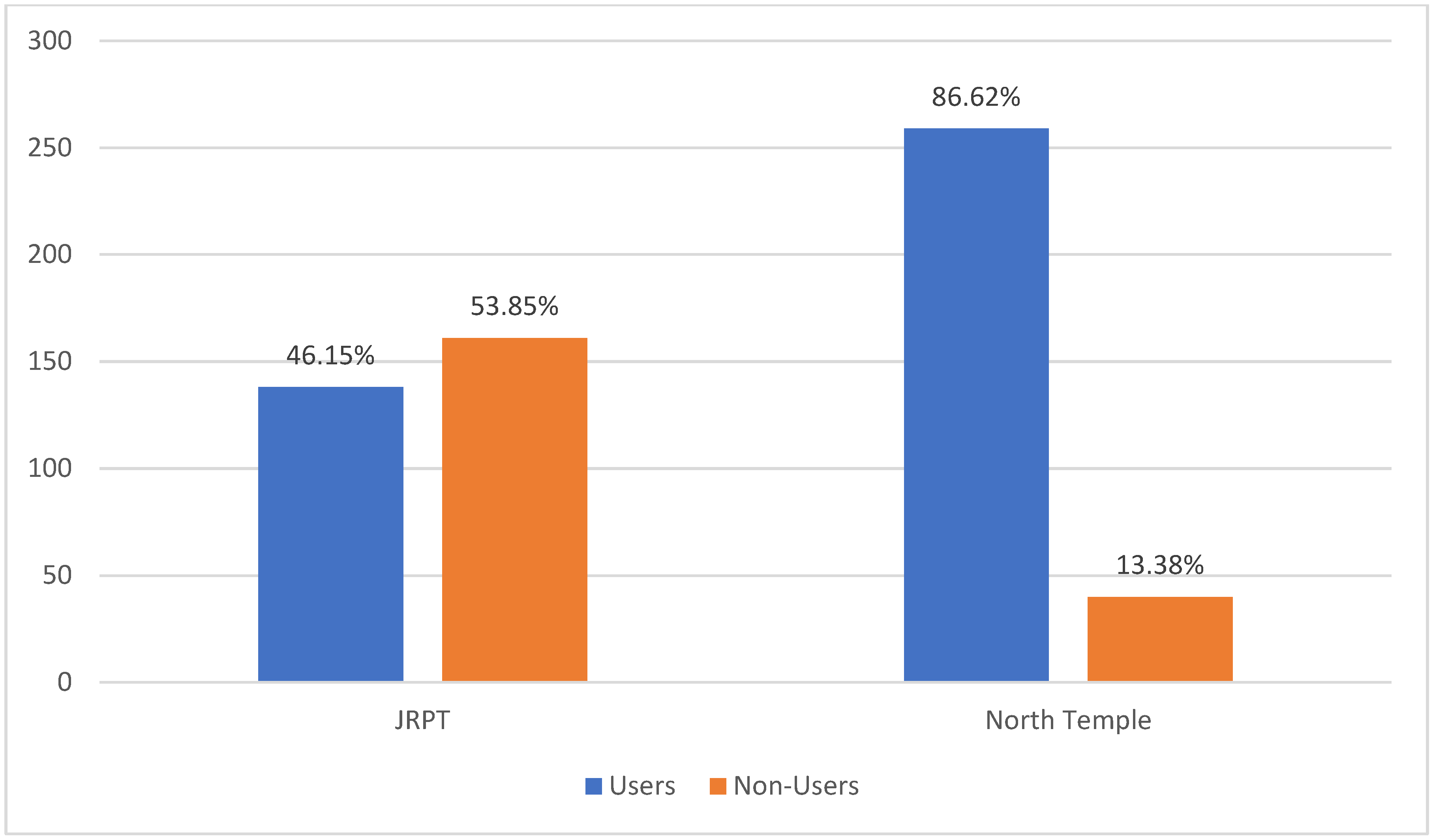
From respondent answers, the number of users for each corridor can be found in
Figure 2. There were 138 people (46%) who indicated using the JRPT, leaving the majority of people, 161 (54%) who did not. Some respondents indicated they had never been to the JRPT. There were 47 people (16%) who fell into this category. Clearly a large percentage of the west side population is not taking advantage of this natural amenity.
North Temple proved to have the opposite results. Survey respondents indicated 259 (87%) of them use North Temple. Forty people (13%) answered that they do not use North Temple. It is apparent that this corridor is heavily utilized by neighborhood residents.
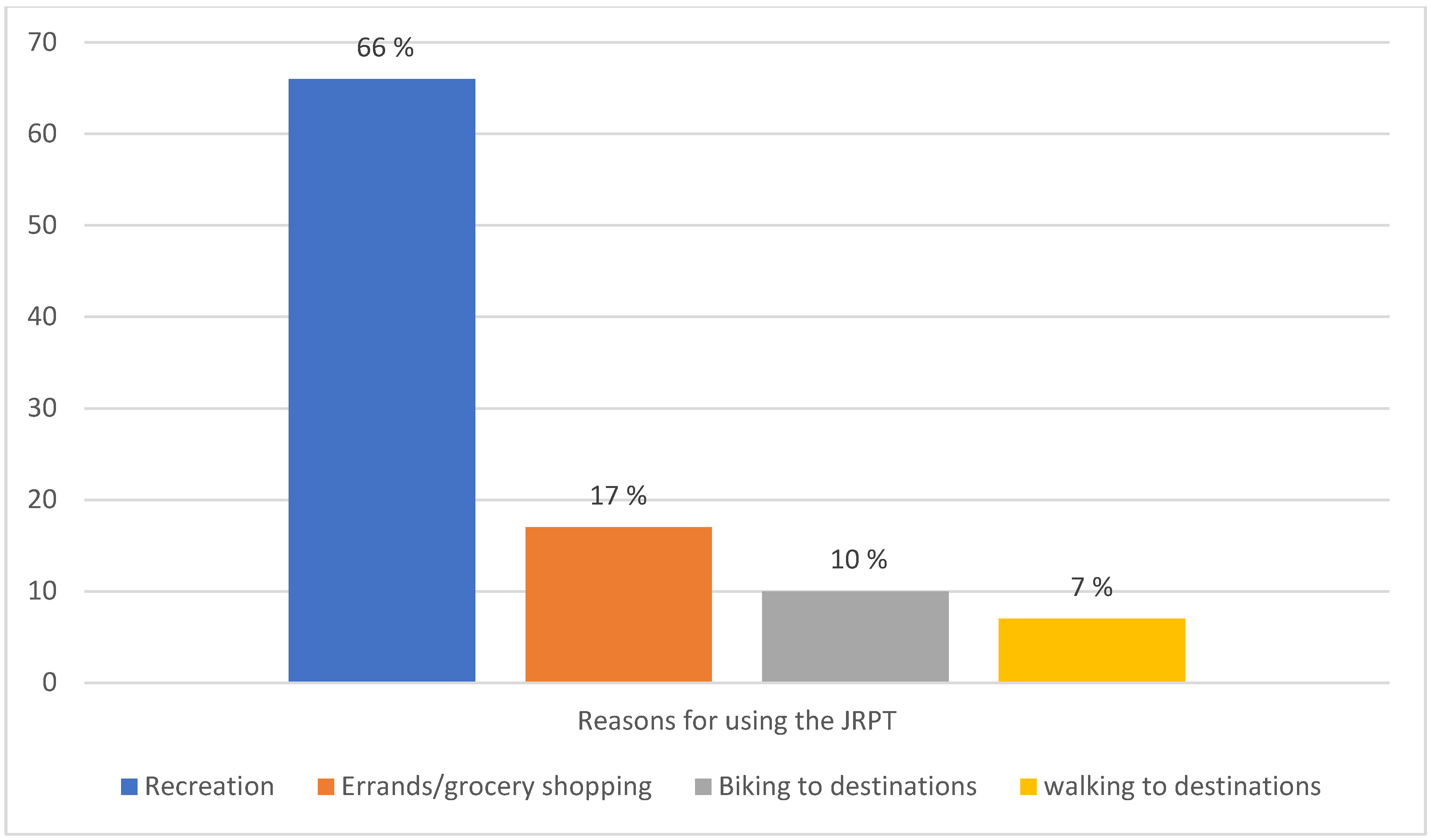
7. Objectives
As indicated earlier in this paper, the JRPT and North Temple have different purposes. To determine the exact reasons people use each corridor, user objectives were examined. For the JRPT, two-thirds (199) of the 299 respondents used the multi-use trail for recreation and pleasure. This use was by far the most popular answer. As shown in
Figure 3, when narrowing down to the 138 people who use the JRPT, 114 respondents (82%) use it for recreation and pleasure. Other responses indicated running errands or commuting to work or school.
Interestingly, the top purpose of North Temple is for forms of entertainment. Answers indicated 108 (36%) of the 299 people surveyed use North Temple for restaurant use. Another 54 people (18%) use North Temple for retail purposes. These two groups combined account for 54% of survey respondents.
What this information indicates is that the purpose of both corridors appears to have some overlap. They are largely frequented for personal purposes. Recreation, pleasure, and entertainment are all things people choose to do with their free time. This information can be helpful when determining the types of destinations that may draw more active transportation users to the JRPT.
8. Modes of Transportation
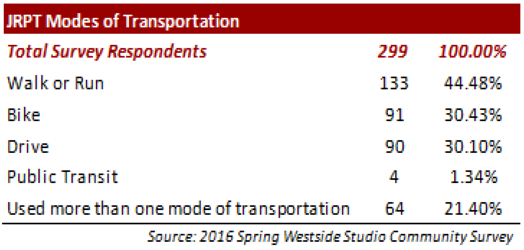
The goal of this paper is to propose measures/actions to increase active transportation. Intuitively, it makes sense that people who walk or bike are going to be the only ones able to use both trails seamlessly. According to survey results, shown in
Figure 4, 44.48% of the respondents walk or run on the JRPT. The second highest mode of transportation was biking with 30.43% indicating this mode of transportation while 30.10% drove to the JRPT. Only 1.34% took public transit while the rest used multiple modes.
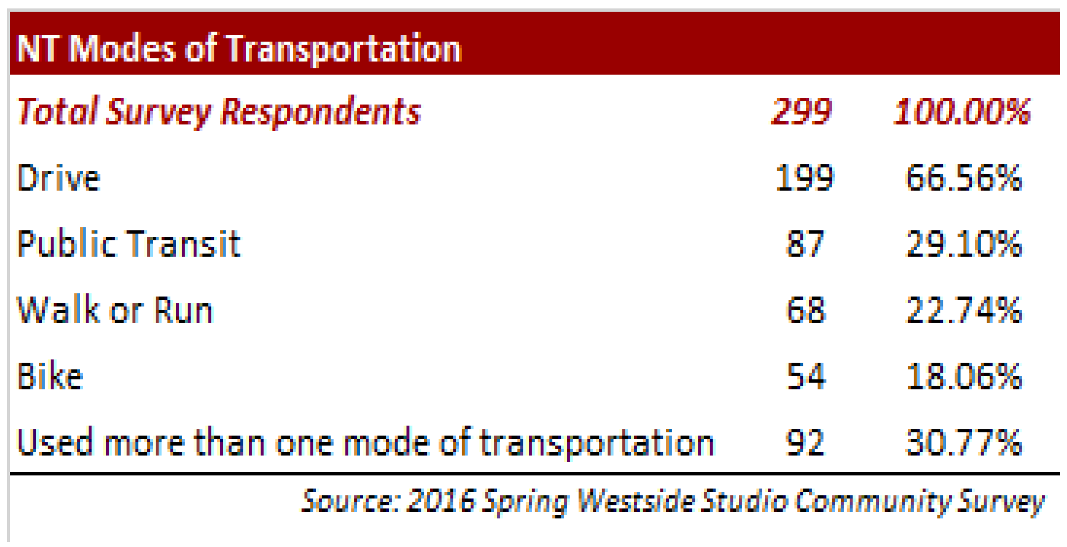
It was no surprise that the most used mode of transportation along North Temple was the automobile (66.56%) chose this answer (see
Figure 5). The next highest mode of transportation was public transit with close to 29.10% of responses. About 22.74% walked or run, while 18.06% of respondents indicated biking as mode of transportation. About 30.77% of survey takers indicated using more than one mode of transportation along North Temple.
From this information it can be concluded that respondents are already using active modes of transportation along the two corridors. However, there seems to be room for increasing active transportation users not only along the JRPT, but also along North Temple.
With the possibility to increase active transportation usership, potential barriers need to be studied. Perhaps there are reasons why residents are choosing to forego biking or walking along these two corridors. Over one-third of the respondents (101 of 299) indicated that there is not much to walk or bike to. This supports our idea of destinations being a draw for active transportation users.
9. Discussion and Conclusions
North Temple is clearly a corridor meant for transit-oriented development (TOD) because of the variety of transportation options available. Including a mixture of developments, such as housing, office, and retail into a neighborhood makes a place more walkable, especially when access to transit is within a half-mile. A secondary goal of TODs is to create a hub of commercial conveniences provided by small- and medium-sized businesses [
12].
In contrast to North Temple, the JRPT is primarily recreational in nature. Given the land uses, mostly residential, surrounding most of the JRPT, with the exception where it connects to North Temple it is not likely that most residents will use the trail for non-recreational purposes such as work and shopping. The population density along the trail is low and it currently does not support additional commercial spaces. In order to increase demand for the trail for non-recreational uses, greater density would need to be added in the form or more residential units and then an increased number of destinations that respond to that density (e.g., coffee shops, neighborhood supermarkets and the like). Right now, the area that connects between North Temple and the JRPT is being envision as a TSA node, so there are plans to add density and destinations in the area. Although the current survey results in the study do not support sufficient non-recreational demand for the JRPT right now, in the long-run the TSA designation is expected to have an effect. Even if the TSA had an effect in increasing walkability, the JRPT would have to be redesigned for non-recreational travel demand. Since the trail was originally built for pedestrians and bicyclist for recreational use, it does not have the infrastructure needed to support non-recreational uses without significant upgrades. The trail would need sufficient access and egress points, signage, restrooms, water fountains, benches, street lights as well as points of interest along the trail such as dog parks, playgrounds, art, restaurants and shopping. Walking and bicycling in the trail do not seem to be sufficient for non-recreational travel. A bus service as a way to travel around the trail would be needed in the future.
The modes of transportation for each corridor overlap with people who choose to bike or walk. The intersection of these two corridors contain the perfect mixture of transportation choices making the land around the intersection an optimal location for mixed-use development projects. The land uses around the intersection of the JRPT and North Temple do not offer any commercial destinations for active transportation users to patronize. The west side has a unique opportunity with the land around this area and with the physical design of the intersection to create entertainment destinations that accommodate those who want to bike or walk.
As mentioned in earlier sections, North Temple has limited entertainment options for west side residents. Adding a variety of destinations, particularly entertainment-based businesses and housing, around the interchange of the JRPT and North Temple can attract active transportation users. The new developments will theoretically make residents’ points of destination more convenient and easier to access. Knowing that the characteristics of a trip’s end influences transportation choice, it seems reasonable to think that building more destinations geared toward recreation, pleasure, and entertainment may entice more people to use the JRPT for their active transportation needs.
Although the west side mainly comprises single-family homes, multi-family housing developments have been popping up. Most of these developments are along North Temple. Multi-family housing is good for the area for many reasons. Two reasons are density and affordable housing. Density helps support the addition of destinations and also prompts active transportation. The availability of affordable housing eases housing cost burdens for lower income families. By combining decreased housing costs and transportation costs, by making active transportation a viable solution, residents may find extra or disposable income in their budgets. This means they may be able to support entertainment and recreational type developments.
The goal of this paper was to evaluate the connectivity between two dissimilar purpose corridors, from a destination perspective, in order to increase the utilization of the JRPT for active transportation by the west side residents. In order to realize that goal, creating opportunities for a wider variety of destinations in close proximity to the JRPT is paramount. New developments adjacent to the intersection of the Jordan River Parkway and North Temple will attract a lot more people to the west side. People may come from other parts of Salt Lake City, county, and beyond to take advantage of these options.
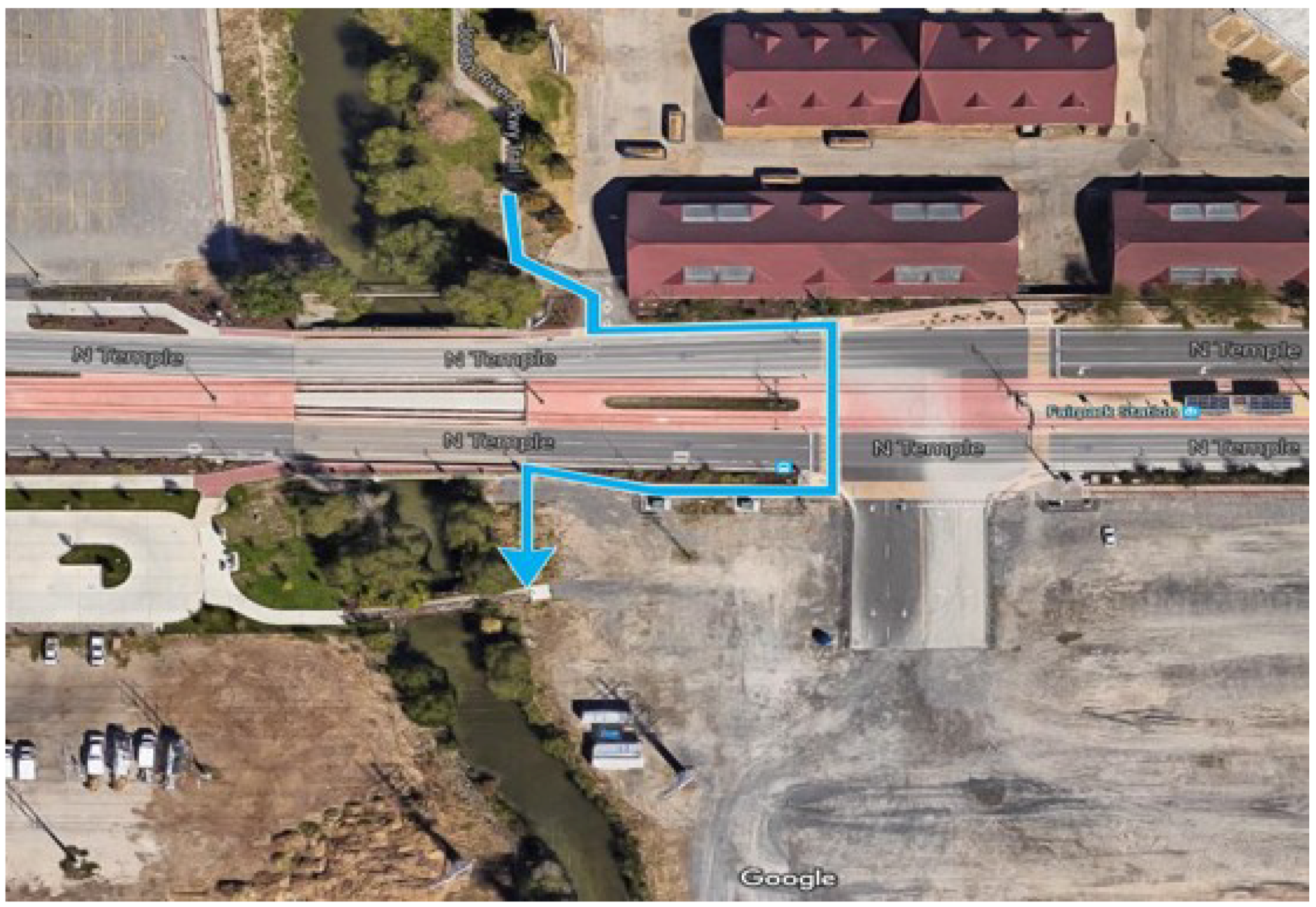
The area is pedestrian progressive and making great strides towards being one of the most walkable places in Salt Lake City. One way of continuing this positive development is to add a crosswalk at 1222 West North Temple to improve the accessibility of the area, as well as the overall connectivity to the JRPT. Currently, pedestrians and cyclists walking the JRPT have to walk to the nearest crossing at 1100 West to cross North Temple. This crossing lands them in an industrial, unwelcoming section that is just east of the JRPT.
Figure 6 is an example of a space where there could be a potential intervention to better connect the JRPT and North Temple—a more straightforward crosswalk could be made and/or signage could be added.
However, adding more destinations within the west side should entice the local community to stay and engage in utilization of these newly added places. The proximity of new businesses to the intersection will be inviting to west side residents because of the ease of access and convenience they offer. The types of businesses and entertainment-based destinations should align with the diversity in ethnicities and culture within the area in order to keep the feeling of a cultural epicenter. Ideas for destinations include coffee shops, bookstores, bars or pubs, specialty grocers, bakeries, fitness centers, boutiques, flea markets, farmers markets, art galleries, and a variety of non-fast-food (possibly ethnic-based) casual and fine dining restaurants. The community does not need to bear the burden of cost in order to bring about entertainment destinations. Beginning with small but relevant destinations can start attracting active transportation users to the area.
Salt Lake City has the opportunity to create a major multi-modal transportation network on the west side. With two major differing use corridors connecting in an area ripe for transit-oriented development, possibilities exist to develop several destinations to make the transportation network a reality. Strengthening the connection of these two corridors by developing land to provide destinations for recreation and entertainment purposes could help decrease the dependency of automobile usage among west side residents, provide transportation solutions through active transportation, and increase overall city and regional connectivity.
Providing alternative transportation options for lower income families helps keep costs down while keeping these families connected to their community. Adding destinations that provide options for deciding how to spend their personal time and limited funds may strengthen connectivity. As stated at the beginning of this paper, we have discussed, “Connectivity is a human right.”

