1. Introduction
Public space plays a major role in the quality of life of citizens. Many public spaces are green spaces, rendering it essential to understand the relations and actions between people and the spaces they use, as well as how spatial elements in green spaces influence these relations. In green spaces, ground modeling, vegetation, and time are the elements that promote these major interconnections. Together, these elements have an unequivocal impact on visibility, connectivity, and accessibility, offering different experiences to users and, to the same degree, granting different usage as time advances.
1.1. Space Syntax
Space syntax is a set of methods with an underlying set of theoretical ideas [
1], which are in continuous development. It is a well disseminated instrument in architecture and urban design studies. Bafna (2003) [
2] describes it as a research method that studies the relations between society and space from the perspective of a general theory of the structure of inhabited space in its various forms, meaning buildings, cities, landscapes, etc. It contains a large semantic network of quantified concepts. This research will focus on isovists and visual connectivity. According to Bafna (2003) [
2] an isovist is a polygon created by delineating the area visible to an observer in that position, assuming a 360-degree field of vision. Alagamy et al. (2018) [
3] define visual connectivity as the extent to which a place can be viewed from other places.
1.2. Space Syntax in Landscape Architecture
Space syntax methodology provides tools to analyze the linguistic characteristics of space – configuration [
4], visibility [
5], and accessibility - and their functional relations to the physical, social, and psychical environment. Existing space syntax research from several authors related to landscape architecture demonstrates the benefits of assessing green spaces. Some of these studies evaluate the effects of planting design in urban parks concluding that it has a significant effect on visibility, but also, that other spatial attributes such as tree height and form could be used for a better understanding of the space [
6,
7]. Other studies analyze pathway configuration characteristics and their relation to senior walking behavior [
8]; evaluate accessibility aspects in nature parks [
9]; analyzing people’s spatial distribution and predicting pedestrian trail use in natural parks [
10]. Green spaces do not always have clear and easy to define boundaries. Zhai and Baran (2013) [
11] noted the difference between defining boundaries among parks and other urban constructions, where sightlines are mainly blocked by buildings, while in parks people can look through branches of trees and shrubs.
The design process is generally the same in architecture and landscape architecture. It starts from a general/conceptual view of the design and moves towards a more detailed final product where the configuration of space and materials is well defined. The choices made for a design are a result of experience and continuous study. Space syntax as a tool that has been developed and studied throughout the years can provide an efficient method of aiding the design process. Dursun (2007) [
12] explores the contribution of space syntax in this endeavor, concluding that it can be an efficient method of aiding in design choices through “evidence-based design” with various tools to evaluate design choices. Li et al. (2009) [
13] studied this matter with the addition of BIM (Building Information Modeling) showing that users can use it in the development of the design at the same time they assess the outcomes and consequences of each choice.
1.3. Three-Dimensionality in Space Syntax
Although space syntax analyzes mainly 2D space, space is actually perceived in three-dimensions (3D). Therefore, to be able to fully understand the space, namely the visibility in the urban space/architecture/green spaces, the third dimension should be added. Kim et al. (2019) [
14] defined visibility as the representing the size of a space that is visually perceived by people and can also be referred to as isovist. Schroder et al. (2007) [
15] describe a methodology and implementation of 3D space syntax with the aim of creating a visibility surface that summarizes the varying degree of visibility values among a set of buildings, but do not consider altimetry nor the visibility on modeled buildings. Kim et al. (2019) [
14] experimented with an urban space and various combinations of building heights, showing that the heights of buildings gradually affect the spaces around them, but does not also consider altimetry of the terrain. These authors do not consider the attributes of vegetation. Morais et al. (2017) [
16] introduced a general notion of tree transparency on the 3D visibility analysis of Casa da Música in Porto and the surrounding areas, considering a difference in visual permeability of the tree crowns in summer and winter and the general form and dimensions of trees, showing relevant differences in the global visibility and permeability of the space. These attributes were studied further by Ascensão et al. (2018) [
17], complementing them with parameters that could be inserted in the DepthSpace 3D software for each species of trees and large shrubs and considering new attributes and parameters. These studies and authors did not consider visual permeability in the analyzes made with the software.
1.4. 3D Space Syntax Software - DepthSpace3D
In recent years, three-dimensional analysis has been a focus of research in space syntax, as is reviewed by Ruth and Conroy Dalton (2015) [
18]. However, this had not yet materialized in the development of open-use software for three-dimensional space syntax analysis before DepthSpace3D was released, expanding on concepts developed in space syntax theory, particularly those regarding augmented visibility graph analysis (AVGA) [
19]. DepthSpace3d is a software developed by some of the authors of the present paper and is freely available at
http://opoarch.com/ds3d download/ for academic use. How space syntax concepts were adapted for three-dimensional analysis was developed in earlier research by Morais (2018) [
20]. The research reported in this paper uses this software, as three-dimensional analysis seems to have some advantages over current two-dimensional syntactic analysis in situations which are particularly fitting to the study of landscape architecture, such as:
Rough altimetry of the terrain, either natural or sought by the designer;
Dynamic volumetric geometries, in size, configuration, elevation, and interpenetration, such as those created by vegetation;
3D analysis could very well be a powerful tool in formalizing the classical theoretical and aesthetical space concepts such as proportions and scales, hierarchy, or rhythm.
1.5. Objectives
The main objectives were to adapt and improve the DepthSpace 3D software to suite the special requisites of landscape architecture discussed in this section and further in the document and evaluate if the developed research is suitable for application to landscape architecture. This research will introduce and describe attributes and parameters to be applied in the aforementioned software, aiming to set a foundation that allows continued development of 3D space syntax in the application to urban parks and gardens, while also attempting to optimize the design process. A trial application of these attributes and parameters in the DepthSpace3D software is developed under the case study urban park in Maia, Portugal.
This paper attempted to answer the following questions: What do people see? What do people see more often? What do people see throughout the year? What do they see throughout time?
1.6. DepthSpace3D Developments for Landscape Architecture
To be able to apply this software to landscape projects and analyses, it was necessary to define a set of attributes to be applied in ground modeling and vegetation, due to the underlying complexity of green spaces. The paper focused on the aforementioned attributes, expanding on the work of Morais et al. (2017) [
16] and Ascensão et al. (2018) [
17]. The proposed attributes are presented in
Section 2.
2. Materials and Methods
2.1. Methods
Firstly, it was necessary to delimitate the study area for the model creation. The study area was based on the plans for the project of the urban park in Maia, located in Portugal. Two types of approach were considered: (a) Relations between the interior and exterior of the park which led to the inclusion of a model area that extends beyond the limits of the project; (b) Relations within the interior of the park.
Following the delimitation of the study area, it was necessary to evaluate which elements had to be present in the model. This specific case study integrated buildings, as well as altimetric differences and vegetation. Since space syntax analysis is usually bidimensional, it rarely or never considers the last two elements, making it necessary to define them in the context of DepthSpace 3D. Attributes and parameters were then defined for vegetation and are explained further in the
Section 2.3.1.
Finally, the model was created taking into account the previously mentioned factors and analyses were made to evaluate and determine their interest in three-dimensional space syntax analysis considering the different vegetation attributes. The diagram represented in
Figure 1 synthetizes the key aspects of the research method.
2.2. Case Study
The case study presented in this research is a landscape architecture project of the urban park in Maia, Portugal. It is located in the city center and connects to several of the city’s main services through the projected path system. Along these paths are several open spaces such as squares, training field, lawns, a skating area, and a lake, also connecting to the parks sports buildings which are a big presence in this space. Some areas have a great density of trees, a diversity of trees species, and different altimetry.
The relevance of this case study lies in the importance of these elements as they have direct implications on the visibility of people, some pre-existing (buildings) and others proposed (terrain modeling, vegetation, lake, lawns, etc.) along the year and time.
2.3. Attributes and Parameters
Aiming to study the aforementioned instances in the context of landscape architecture, it was essential to decide on a set of attributes and parameters to apply to vegetation. Due to the complexity that involves the natural development of plant life, it had to be investigated to achieve a set of summarized concepts to be employed in the analysis.
2.3.1. The Distinctive Case of Vegetation Conceptualization
Plants are live and continuously evolving structures, showing great variability, affecting visibility and the use of space through time. These parameters enable the assessment of space considering time.
To obtain the attributes and parameters for landscape architecture it was necessary, at an initial stage, to understand which could be applied to 3D space syntax analysis. To fulfill this endeavor, an extensive literature review to find the possible attributes and parameters to apply in the development of this software was undertaken. From this review, Ascensão et al. (2018) [
17] defined four attributes to be applied for trees and large shrubs:
Dimension [
17], involving three parameters: Height, width, and trunk height, defined by Moreira (2008) [
21]. Trunk height is considered from the ground to the first branches.
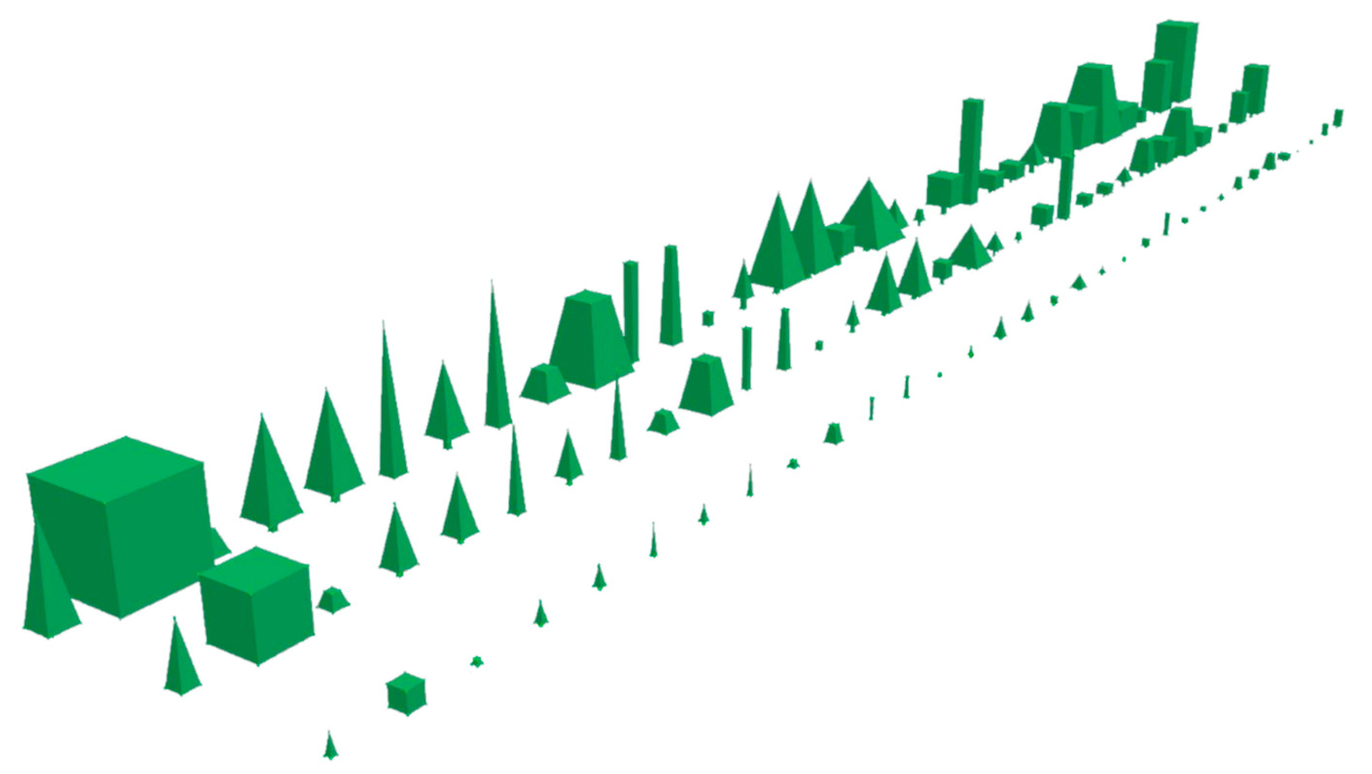
Form [
17], defined by Moreira (2008) [
21]. 5 simple volumes/forms were chosen: Conical, rounded, wide, pyramidal, and columnar (
Table 1).
Growth speed [
17] was considered as slow, medium, and fast based on Viñas et al. (1998) [
22] and Costa (2015) [
23] considering the dimensions after 20 years of plant growth (
Table 1).
Visual permeability of the crown in winter and summer [
17] was considered opacity applied to deciduous and evergreen plants. For the latter, the opacity values were considered the same in winter and summer. The method used for evaluating the permeability of the crown encompasses three phases:
- (1)
Picking images that represent naturally, well-developed adult specimens for each species;
- (2)
Determining crown transparency, adapting the methods of Clark, Lee, and Araman (2003) [
24] and Borianne et al. (2017) [
25] consisting of a simple delineation of the crown, acquiring the total number of pixels (Tp) (100% of the crown area) and acquiring the visible light area through the crown (Sp) (number of pixels corresponding to the visible light/sky area, through the crown);
- (3)
Finally, visual permeability (P) was calculated through the following formula:
All these attributes were studied, quantified, and applied for a set of trees and large shrubs [
17]. The species of trees and large shrubs present in
Table 1 were chosen because they are listed in the planting design of the case study—urban park in Maia, Portugal.
2.4. DepthSpace 3D Model Creation
The model developed in DepthSpace3D comprises three conceptual types of spaces - the viewed, the viewing, and the obstacle spaces.
The viewed space has 2 components: (a) The ground, buildings and vegetation surfaces (physically identical to the obstacle spaces but conceptually different); (b) The global volume, corresponding to the ‘air’ modelled by a tridimensional grid, vertically ten meters apart; and horizontally three meters apart.
The viewing space is the space where the viewing subjects can move, as opposed to the entirety of the studied volume.
The obstacle (to visibility) space is modelled by the surfaces of the ground, considering the curved topography, the facades and other solid surfaces (buildings, trees, and large shrubs, etc.).
The 3D model was created in the DepthSpace3D software, considering the attributes and parameters presented in
Table 1. It was modelled according to the project plans which include proposed vegetation and its attributes (
Figure 2), ground modeling, and the preexisting structures such as buildings.
3. Results and Discussion
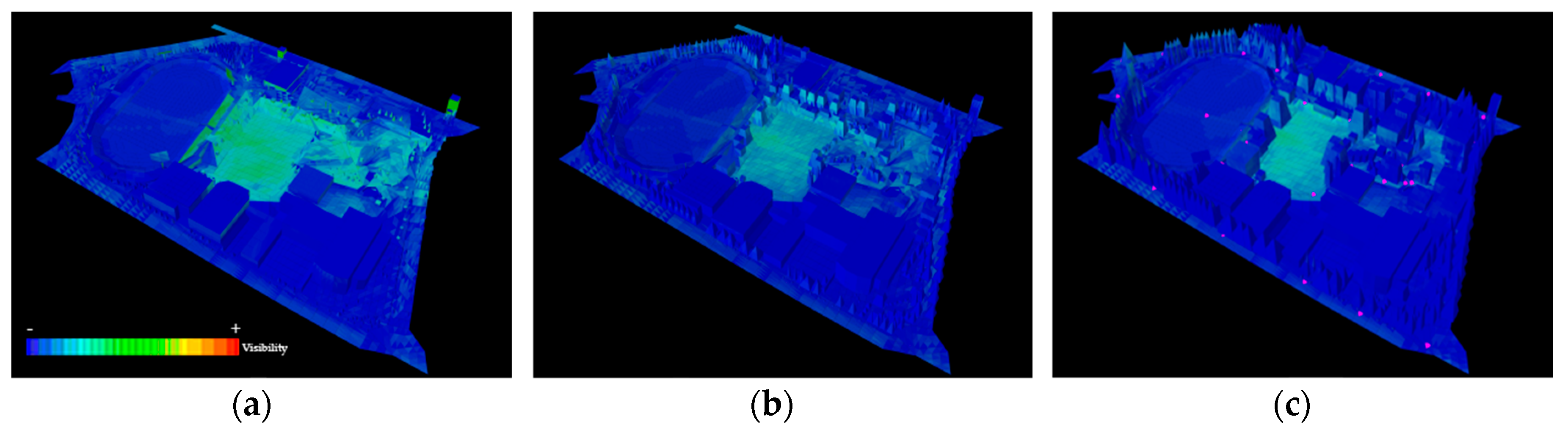
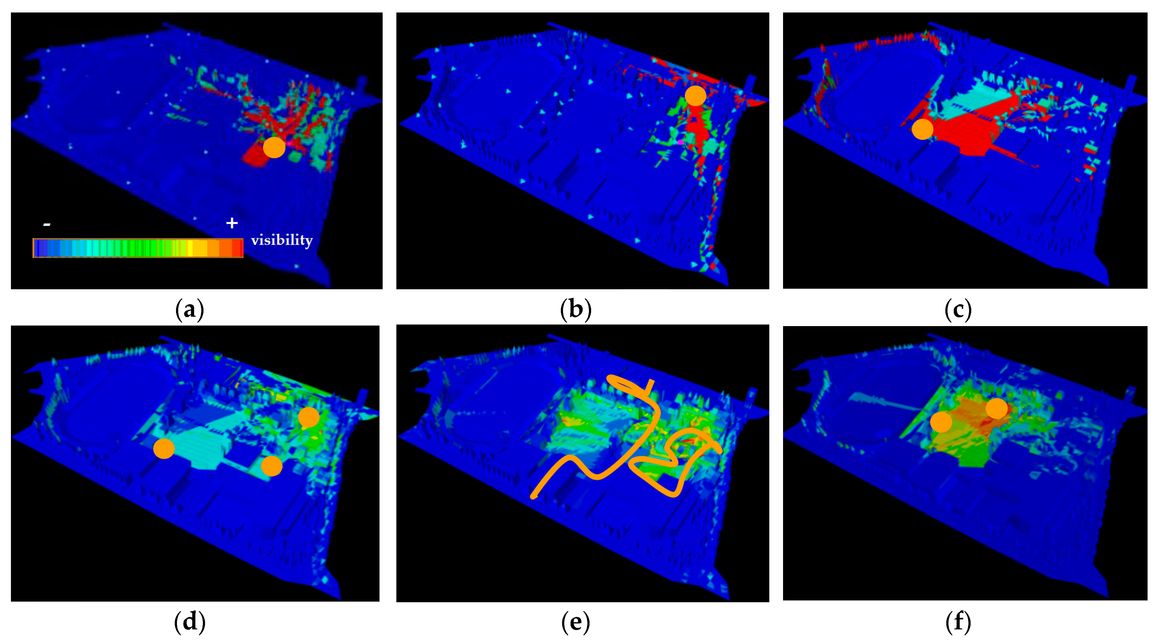
In landscape architecture, visualizations create a view of what the space can eventually become and what will be seen from a certain point of view, but these visualizations try to represent what the space will become in the idea of the designer and, in a majority of cases, are centered on the best views. To represent objectively what is, or will be seen throughout the space, year, and time, a 3D model was created in DepthSpace 3D considering the attributes of vegetation and terrain modeling. The trial application for the urban park, can define what will be seen through all of the space. The images present a gradient of colors that goes from dark blue to red, which represent the amount of visibility on a certain location. A dark blue color indicates that the space has no visibility from the chosen points and a red color indicates that the space is very visible from the chosen points.
3.1. Effects of Time on Visual Connectivity
One of the most important attributes related to vegetation is time. In
Figure 3, it is possible to visualize the effects of time on the park’s global visibility, by considering vegetation growth. The differences in visibility are clear. As vegetation grew the spaces appeared more defined opening and closing and offering different views of space, creating variability over time. Considering the importance of planting design and visual permeability of the trees and in an initial and global exercise, simulations were developed where it was possible to understand the influence of this attribute in visual connectivity.
The presented results originated from inserted viewpoints which were predicted as important points and paths inside the park. These included notable viewpoints from higher places in the park and various paths on the exterior and interior of the park. The introduction of the growth speed attribute to vegetation allowed a close to realistic notion of the visibility of the space throughout time, demonstrating its effects on visual connectivity throughout time.
The case study of Maia Park (
Figure 4), showed low levels of visibility from the interior to the exterior of the park but showed good visibility to the spaces inside it, while not completely disclosing the whole park.
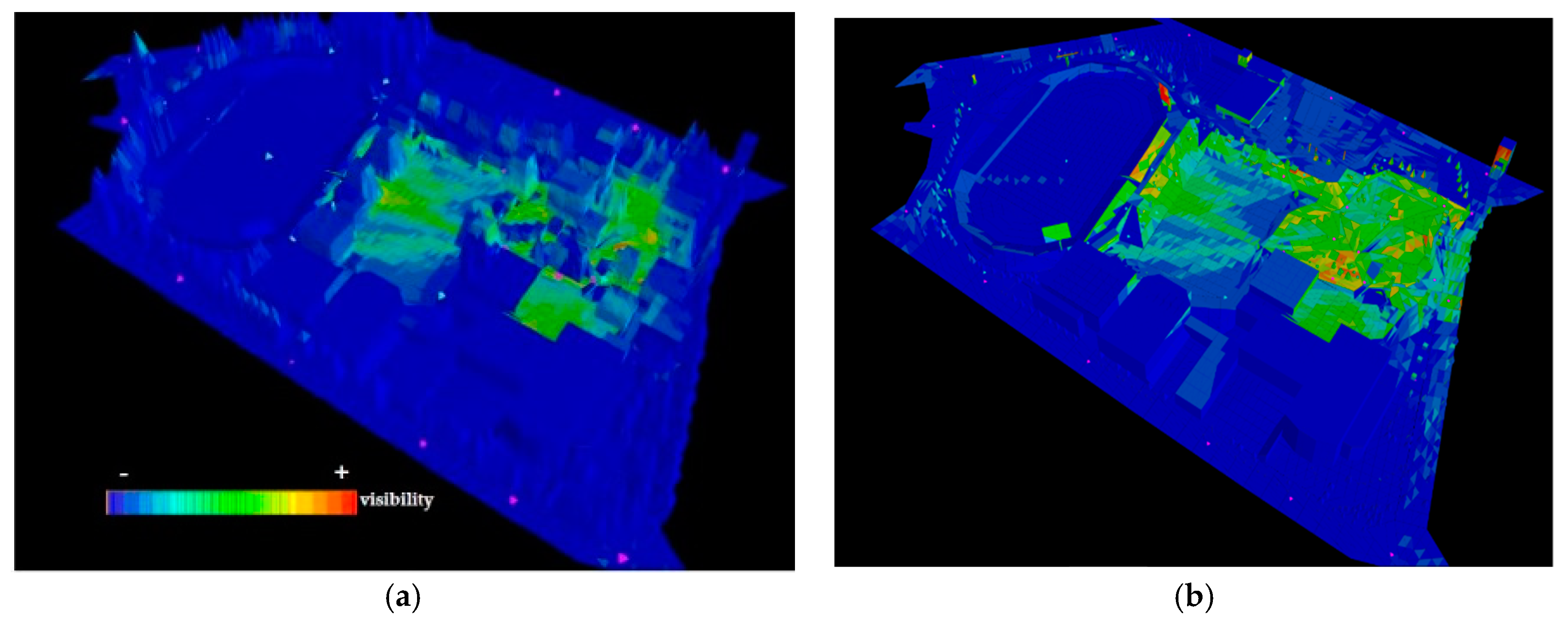
3.2. Effects of Visual Permeability in Winter and Summer on Visual Connectivity
The analysis also contributed to understand the spatial design in winter and summer months (
Figure 5). Subtle manipulation of vegetation and topography could be experimented with until the design expectations were validated through visibility analysis, resulting in the final design. It was also possible to verify that the main entrance behaves as a logical entry, allowing high levels of visual permeability between the park and its immediate surroundings.
3.3. Other Analyses
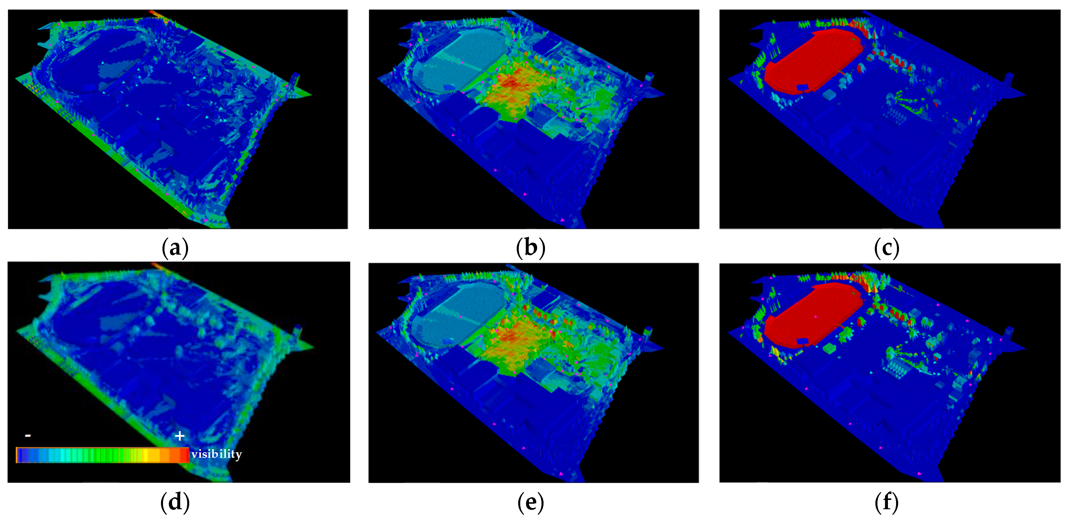
Visibility maps for additional zones were created (
Figure 6) with the objective of understanding the definition of the designed spaces. During the project phase, it was the intention of the landscape architect that the park should not be grasped in its entirety from a single point but only through meandering inside the park. As it is perceptible from the images, this objective was successful mainly due to the proposed terrain modeling and location of the different species of trees and large shrubs. It must be noted, however, that the loss of visual connectivity happens mainly due to the existence of buildings and altimetry, because vegetation always allows some visual permeability, adding to the visual connectivity values. The spaces appeared clearly defined, showing variations between high and low levels of visual connectivity, appealing to movement along the park.
Three-dimensional analysis was an essential contribution to understanding how the trees and large shrubs affected visibility throughout the year, by allowing for a visualization of the differences between summer and winter in the park’s visibility. Although in some cases the differences were visible at ground level, they were most discernable at the higher points in space (
Figure 5a,c,d,f). This happened because the visual permeability is calculated through the crown of the trees and also relates to form, as trees in the simulation, had different trunk heights and they allowed the passage of visibility below their crowns. Visibility changes were most perceptible at ground level, when points that generate visibility were located at higher points in space (
Figure 5b,e). In (
Figure 5a,b,d,e) it is possible to visualize a reduction in visibility from the inside to the outside of the park and vice versa, visual connectivity is low meaning people inside the park will barely be able to see the outside. Contrary to what happens with buildings, trees, and large shrubs never show full opacity allowing for visual permeability even during summer months. Deciduous trees and shrubs are the ones which present lower values of opacity in winter and summer months, contrary to evergreens, meaning that the presence of distinct species implies different visibility values.
Regarding the design process, upon testing the vegetation attributes it was possible to understand the visibilities from the static areas (gazebo, bar) and dynamic areas (pathways) and apply corrections to the design. In these simulations it was possible to understand that the presence of an overlooked element, in this case a tree in the space cutting visibility from the bar to the training field of the park. It was intended that the people from the bar could watch what was happening in the field in its totality. Our method allowed for this small change to be made so as to address this issue. This example shows the possibilities of DepthSpace 3D in aiding the design process. It must be noted that, since the software is still in development, iteratively changing the design in the 3D model takes some time due to the recalculation time. It is expected that this issue will be resolved with the continuous development of the software.
4. Conclusions
This paper set out to contribute to both the elaboration and evaluation of landscape architecture projects by developing and expanding on space syntax tools. The methodology was twofold and iterative.
Three-dimensional space syntax software was used throughout the design process of a park as an aid for objective assessment and decision making. Space syntax methodology allows for an immediate understanding of visibility, thus proving effective in answering a series of questions about the initial design of the park - What do people see? What do people see more often? What do people see throughout the year? What do they see throughout time? As a result, it was possible to understand the relationship between the interior and exterior of the park to assure convergence with natural movement, trees were moved and replaced to accentuate the visibility of certain points while ensuring the privacy of other areas.
The attributes from landscape architecture, some related to problems arising from the design process, were integrated into DepthSpace3D. The experimental application of the attributes and parameters in the DepthSpace3D software allowed for an understanding of the interest of this software during the development of the landscape architecture project. It proved itself to be a useful tool, not only in studying and evaluating the effects of the final design, but also during project development. The software was developed along with the urban park project, working to accommodate specific necessities that had not been foreseen. This allowed for the development of a series of tree-objects with varying growth patterns and opacities, as well as fundamental alterations in the way the software works.
The main challenges of this research concerned the obtainability of the attribute values. Fortunately, there is extensive literature for most of the proposed attributes (dimensions, form, and growth speed). The most complex issue lies with obtaining visual permeability values that translate close to reality values into the software. The visual permeability implies extensive work to evaluate each species and obtain the values as explained previously. It is a process in continuous progress, but the results obtained in the experimental application lead us to believe that the attributes and parameters relating to vegetation are of great interest, not only for landscape architects but also for a wide community of professionals of diverse areas in urban design.
The connection between analysis and design proved a useful step both towards the development of a successful design, and the furthering of a useful tool for landscape architecture. Future work should expand this even further. In addition, space syntax theory provides designers with other quantified concepts that relate to a spatial configuration for understanding expected movement and interaction in space which can contribute to understanding the designed spaces.
Further work should evolve to include a larger database of vegetation to be utilized inside the software allowing for a wider application of the software in other landscape architecture projects such as parks and gardens, but also in urban design to evaluate the effects of trees and topography on a tridimensional spectrum at an urban scale.
Author Contributions
Conceptualization: A.A., C.F. and L.C.; Methodology: A.A., C.F. and L.C.; Software: F.M. and C.R.; Formal Analysis: F.M. and C.R.; Investigation: A.A., C.F., L.C., F.M. and C.R.; Resources: F.M. and C.R.; Data Curation: F.M.; Writing-Original Draft Preparation: A.A.; Writing-Review and Editing: A.A., C.F., L.C., F.M. and C.R.; Supervision: C.F., L.C., F.M.
Funding
This research was funded by CESAP, CRL—Project OPO’Arch Formal Methods—Program NORTE2020—operation NORTE-01-0246-FEDER-000013.
Conflicts of Interest
The authors declare no conflict of interest. The funders had no role in the design of the study; in the collection, analyses, or interpretation of data; in the writing of the manuscript, and in the decision to publish the results.
References
- Hillier, B.; Hanson, J. The Social Logic of Space; Cambridge University Press: Cambridge, UK, 1984; ISBN 978-0-521-23365-1. [Google Scholar]
- Bafna, S. Space Syntax: A brief introduction to its logic and analytical techniques. Environ. Behav. 2003, 35, 17–29. [Google Scholar] [CrossRef]
- Alagamy, S.F.; Al-Hagla, K.; Anany, Y.; Raslan, R. An integrated approach for analysing connectivity in atria. Alex. Eng. J. 2018. [Google Scholar] [CrossRef]
- Benedikt, M.L. To Take Hold of Space: Isovists and Isovist Fields. Environ. Plan. B Plan. Des. 1979, 6, 47–65. [Google Scholar] [CrossRef]
- Turner, A. From isovists to visibility graphs: A methodology for the analysis or architectural space. Environ. Plan. B Plan. Des. 2001, 28, 103–121. [Google Scholar] [CrossRef]
- Mahmoud, A.H. Integrating Space Syntax Theory in Sustainable Planting Design of Parks. In Built and Natural Environment Research Papers; Northumbria University: Newcastle, UK, 2011; Volume 4. [Google Scholar]
- Mahmoud, A.H.; Omar, R.H. Planting Design for Urban Parks: Space Syntax as a Landscape Design Assessment Tool. Front. Archit. Res. 2015, 4, 35–36. [Google Scholar] [CrossRef]
- Zhai, Y.; Baran, P.K. Do configurational attributes matter in context of urban parks? Park pathway configurational attributes and senior walking. Landsc. Urban Plan. 2016, 148, 188–202. [Google Scholar] [CrossRef]
- Setola, N.; Marzi, L.; Torricelli, M.C. Accessibility Indicator for a trails Network in a Nature Park as Part of the Environmental Assessment Framework. Environ. Impact Assess. Rev. 2018, 69, 1–5. [Google Scholar] [CrossRef]
- Zhai, Y.; Baran, P.K.; Wu, C. Can trail spatial attributes predict trail use level in urban forest park? An examination integrating GPS data and space syntax theory. Urban For. Urban Green. 2018, 29, 171–182. [Google Scholar] [CrossRef]
- Zhai, Y.; Baran, P.K. Application of space syntax theory in study of urban parks and walking. In Proceedings of the Ninth International Space Syntax Symposium, Seoul, Korea, 31 October–3 November 2013; Sejong University Press: Seoul, Korea, 2013; Volume 32, pp. 1–13. [Google Scholar]
- Dursun, P. Space syntax in architectural design. In Proceedings of the 6th International Space Syntax Symposium, Istanbul, Turkey, 12–15 June 2007; Volume 56, pp. 1–12. [Google Scholar]
- Li, Y.; Lertlakkhanakul, J.; Lee, S.; Choi, J. Design with space syntax analysis based on building information model: Towards an interactive application of building information model in early design process. In CAADFutures; Les Presses de l’Université de Montréal: Montreal, QC, Canada, 2009; pp. 502–514. [Google Scholar]
- Kim, G.; Kim, A.; Kim, Y. A new 3D space syntax metric based on 3D isovist capture in urban space using remote sensing technology. Comput. Environ. Urban Syst. 2019, 74, 74–87. [Google Scholar] [CrossRef]
- Schroder, C.; Mackaness, W.; Reitsma, F. Quantifying urban visibility using 3D space syntax. In Proceedings of the Geographical Information Science Research UK Conference, Maynooth, Ireland, 11–13 April 2007; pp. 359–366. [Google Scholar]
- Morais, F.; Vaz, J.V.; Viana, D.L.; Carvalho, I.C.; Ruivo, C.; Paixão, C.; Tejada, A.; Gomes, T. 3D Space syntax analysis case study: Casa da Música. In Proceedings of the 11th Space Syntax Symposium, Lisbon, Portugal, 3–7 July 2017; Departamento de Engenharia Civil, Arquitetura e Georrecursos, Instituto Superior Técnico: Lisbon, Portugal, 2017; Volume 169, pp. 11–13. [Google Scholar]
- Ascensão, A.; Ruivo, C.; Morais, F.; Costa, L. Urban park in Maia—Porto: A case study of application of ‘space syntax’ to landscape architecture. J. Digit. Landsc. Archit. 2018, 3, 217–226. [Google Scholar] [CrossRef]
- Dalton, R.; Dalton, M. The problem of representation of 3D isovists. In Proceedings of the 10th International Space Syntax Symposium, London, UK, 13–17 July 2015; Space Syntax Laboratory, The Bartlett School of Architecture, University College London: London, UK, 2015; Volume 151. [Google Scholar]
- Varoudis, T.; Penn, A. Visibility, accessibility and beyond: Next generation visibility graph analysis. In Proceedings of the 10th International Space Syntax Symposium, London, UK, 13–17 July 2015; Space Syntax Laboratory, The Bartlett School of Architecture, University College London: London, UK, 2015; Volume 152. [Google Scholar]
- Morais, F. DepthSpace3D: A New Digital Tool for 3D Space Syntax Analysis. In Formal Methods in Architecture and Urbanism; Cambridge Scholars Publishing: Cambridge, UK, 2018; ISBN 978-1527507623. [Google Scholar]
- Moreira, J.M. Árvores e Arbustos em Portugal; Argumentum: Lisboa, Portugal, 2008; ISBN 978-972-8479-59-6. [Google Scholar]
- Viñas, F.N.; Solanich, J.P.; Vilardaga, X.A.; Montlló, L. El Árbol en Jardinería y Paisajismo; Ediciones Omega, S.A: Barcelona, Spain, 1992; ISBN 84-282-0878-6. [Google Scholar]
- Costa, L.C. A Vegetação na Implementação de Projetos de Execução em Arquitetura Paisagista. Ph.D. Thesis, Caracterização e Definição de Critérios de Avaliação, Faculdade de Ciências da Universidade do Porto, Porto, Portugal, 2015. [Google Scholar]
- Clark, N.A.; Lee, S.-M.; Araman, P.A. Finding a good segmentation strategy for tree crown transparency estimation. In Proceedings of the 19th Biennial Workshop on Color, Photography, Videography and Airborne Imaging for Resource Assessment, Logan, UT, USA, 6–8 October 2003; American Society for Photogrammetry and Remote Sensing: Bethesda, MD, USA, 2003. [Google Scholar]
- Borianne, P.; Subsol, G.; Caraglio, Y. Automated efficient computation of crown transparency from tree silhouette images. Comput. Electron. Agric. 2017, 108–118. [Google Scholar] [CrossRef]
© 2019 by the authors. Licensee MDPI, Basel, Switzerland. This article is an open access article distributed under the terms and conditions of the Creative Commons Attribution (CC BY) license (http://creativecommons.org/licenses/by/4.0/).

 ,
, 


