Connecting Soft and Hard: An Integrating Role of Systems Dynamics in Tsunami Modeling and Simulation
Abstract
1. Introduction
2. Materials and Methods
2.1. Literature Analysis
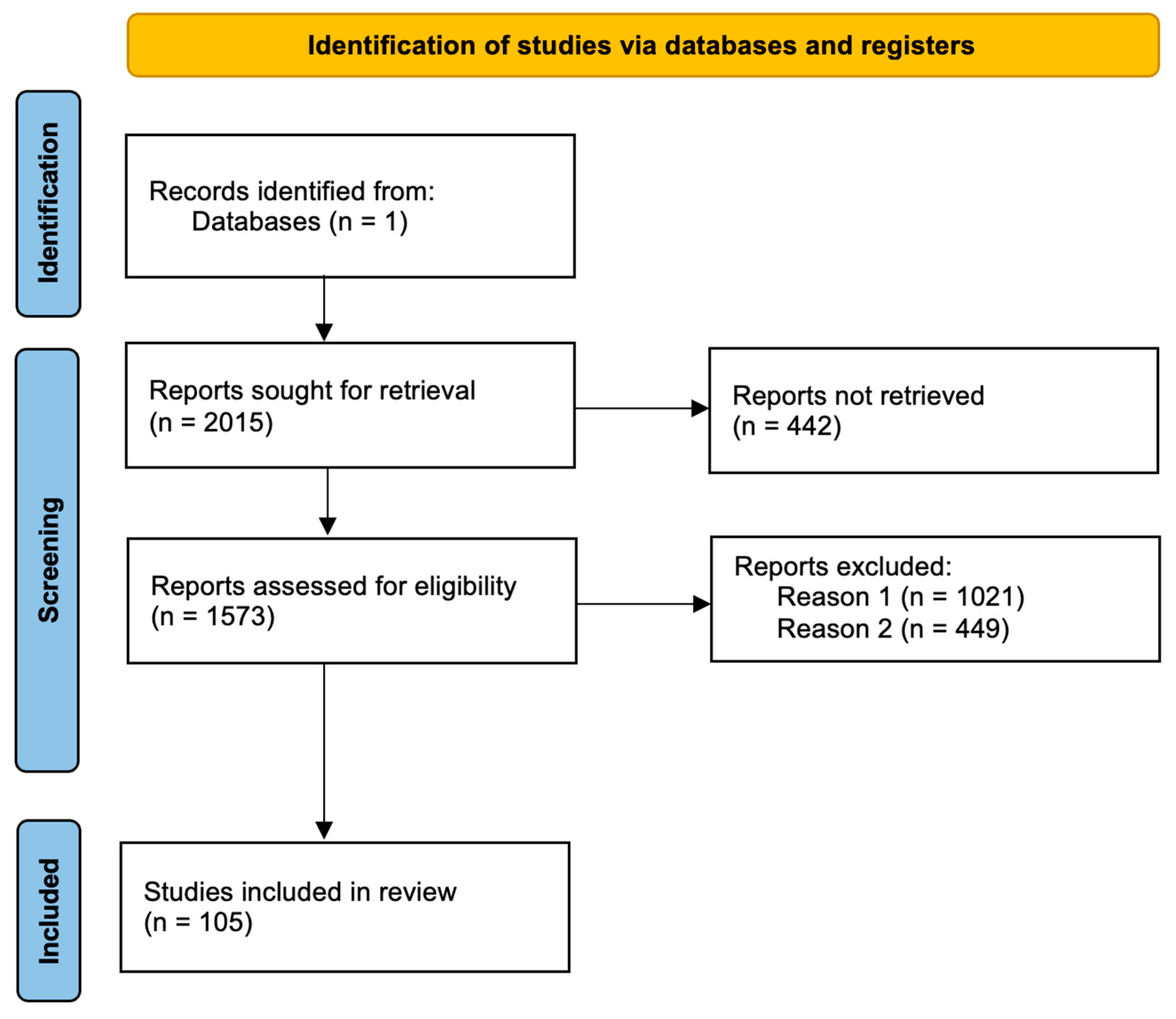
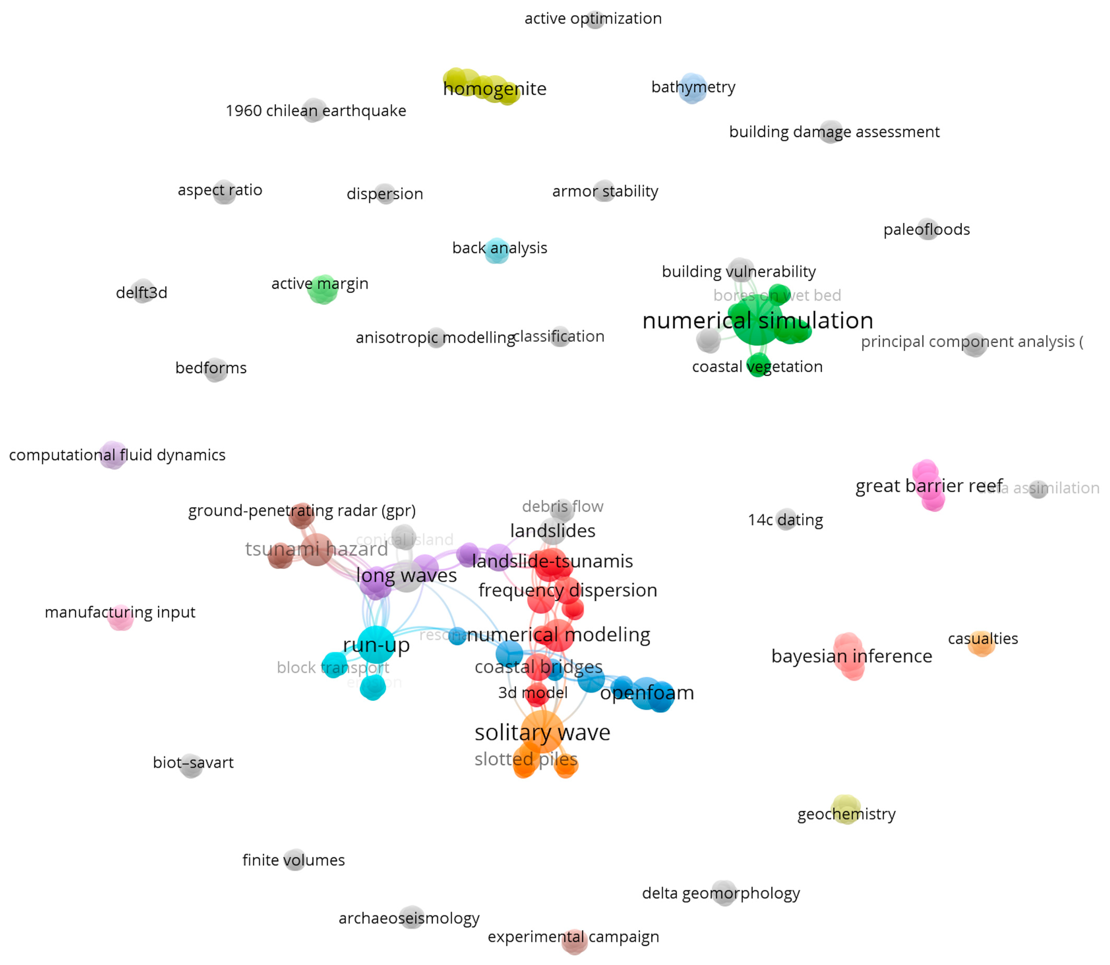
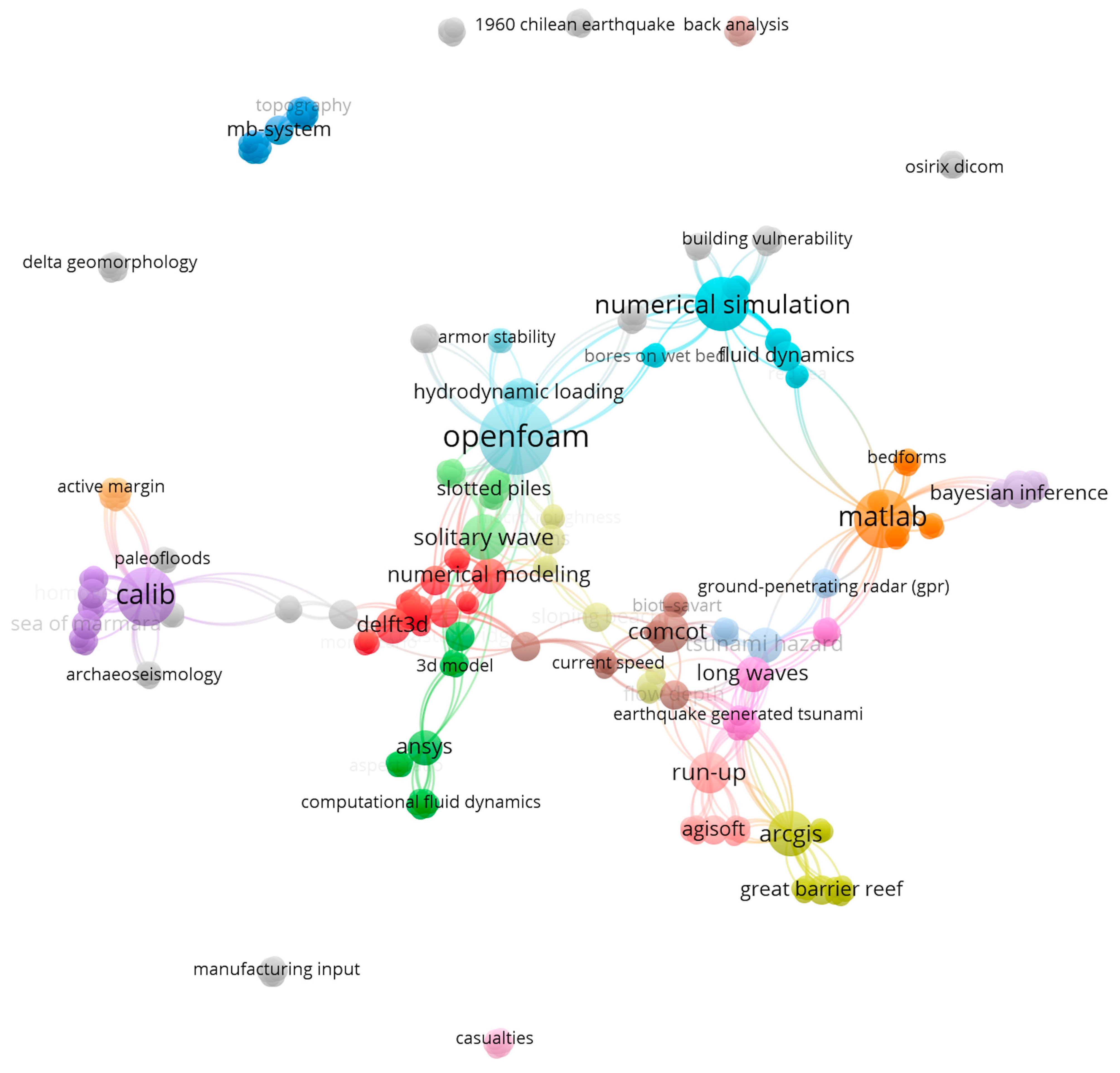
2.1.1. Tsunami (Topic)
Refined by: Document Types: Articles, Publication Years: 2023 or 2022 or 2021 or 2020 or 2019 or 2018 or 2017 or 2016 or 2015 or 2014 or 2013 or 2012 or 2011 or 2010
2.1.2. Tsunami (Topic) and Water (Topic)
Refined by: Document Types: Articles, Publication Years: 2023 or 2022 or 2021 or 2020 or 2019 or 2018 or 2017 or 2016 or 2015 or 2014 or 2013 or 2012 or 2011 or 2010
2.2. Model Development
- Identification of key topics in the scientific literature based on the literature review;
- Classification of variables into distinct groups to develop particular model sectors or modules;
- Identification of causal links among variables and feedbacks, i.e., causal loop diagrams;
- Determination of time units (hours);
- Transformation to a simulable model, i.e., development of stock and flow diagrams;
- Performance of model validation tests [19]—structural validity (boundary adequacy, parameter verification, dimensional consistency) and behavioral validity (behavior pattern test, extreme condition test, sensitivity test).
3. Results
3.1. Application of Methods and SW Tools in the Current Research of Tsunamis
3.2. SD Model of Tsunami-Related Phenomena
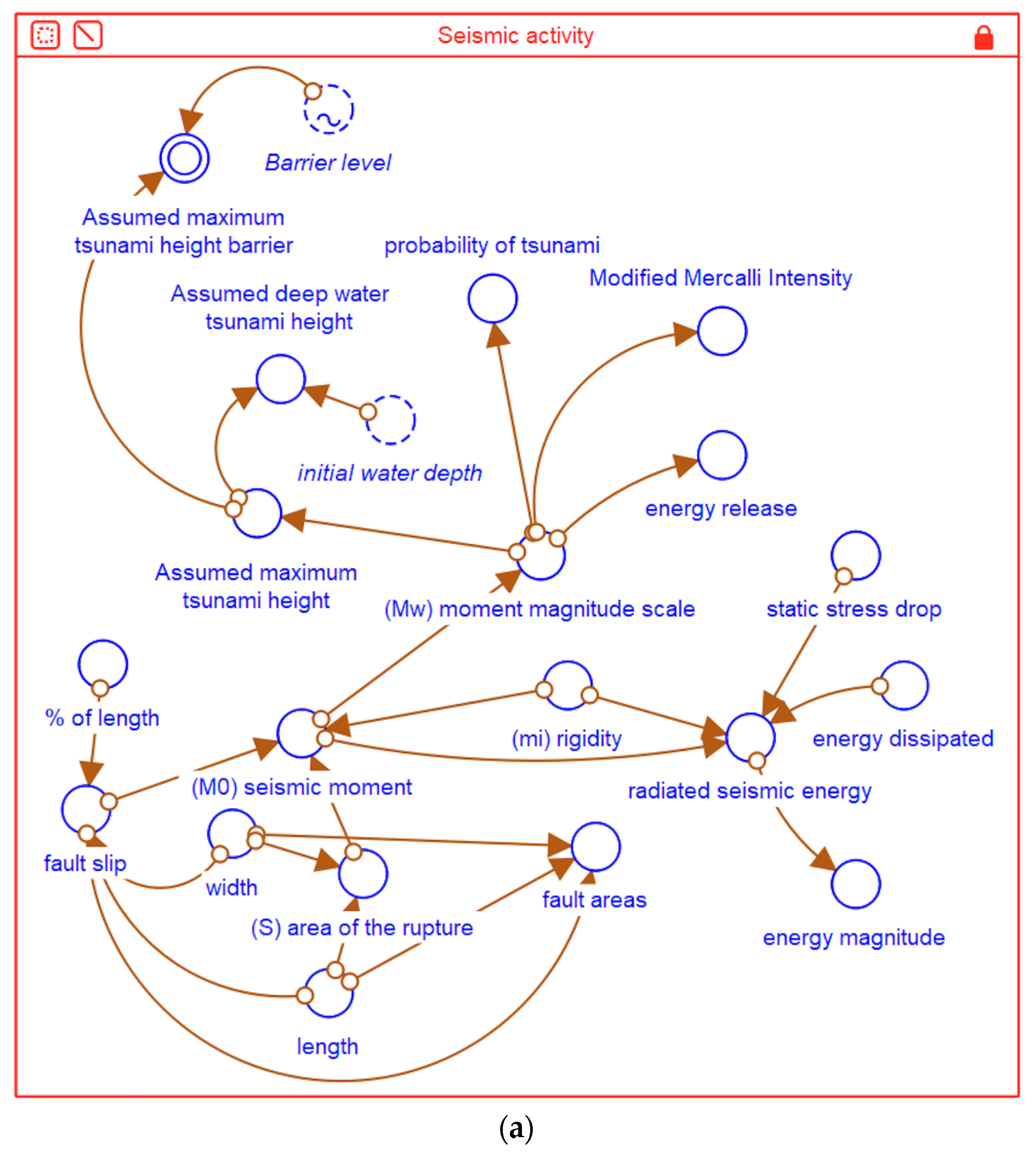
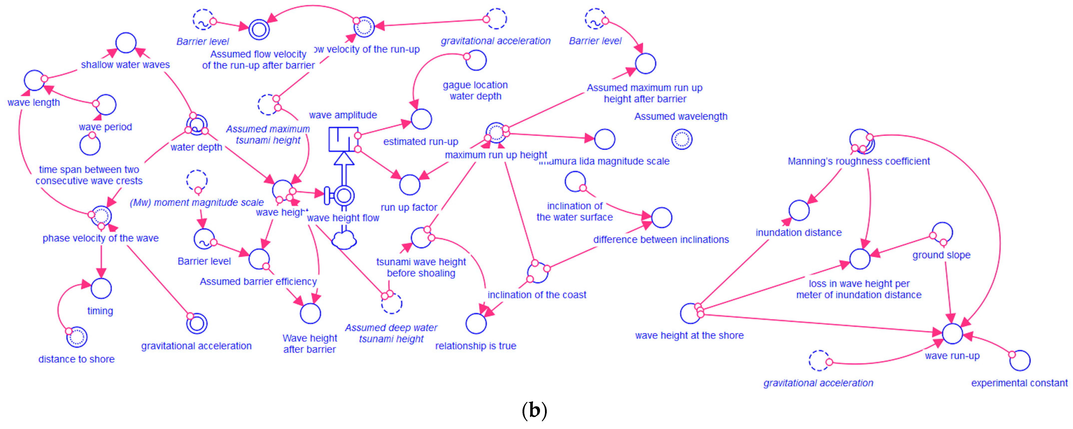
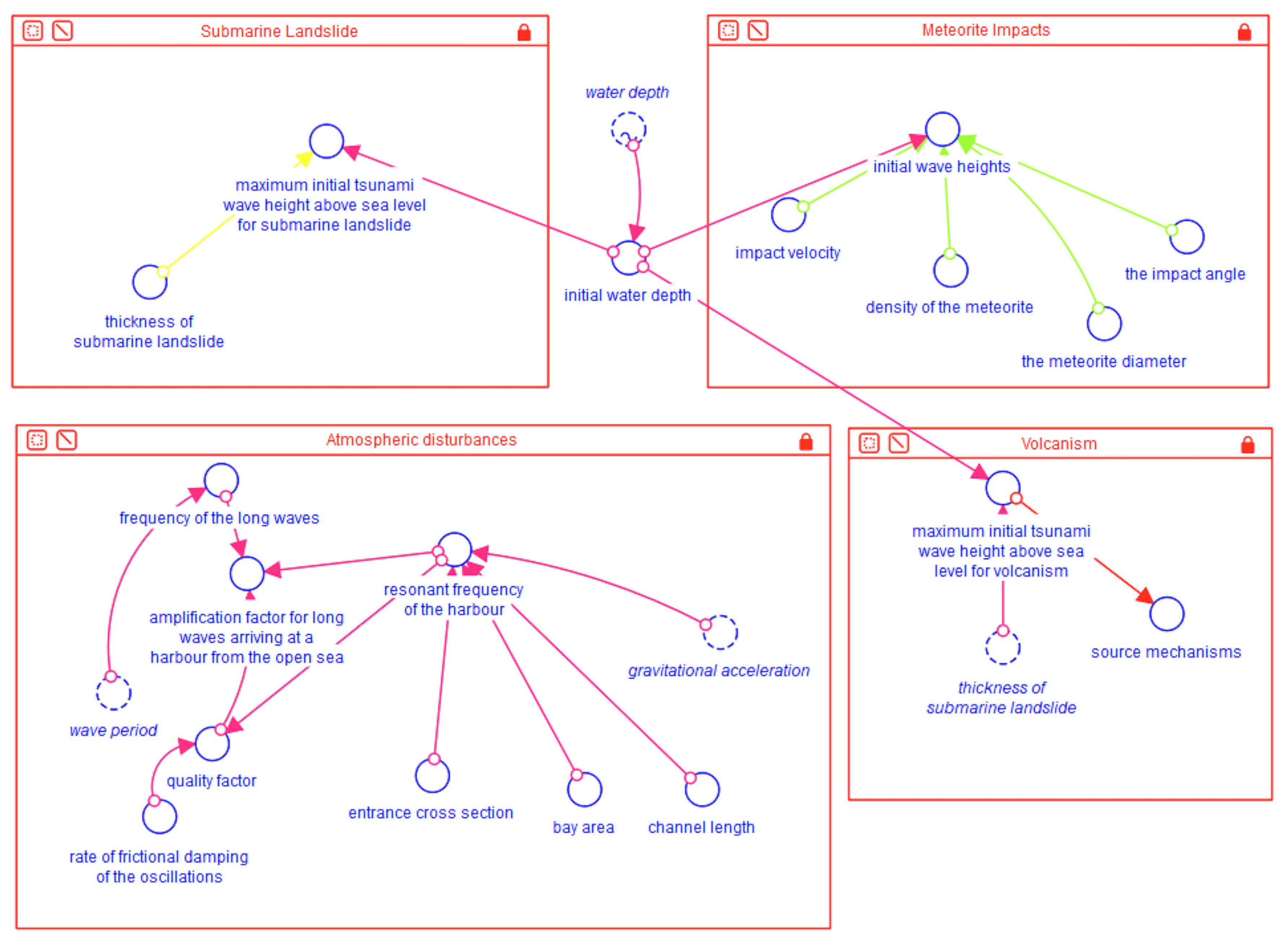
3.2.1. The Formation of the Tsunami
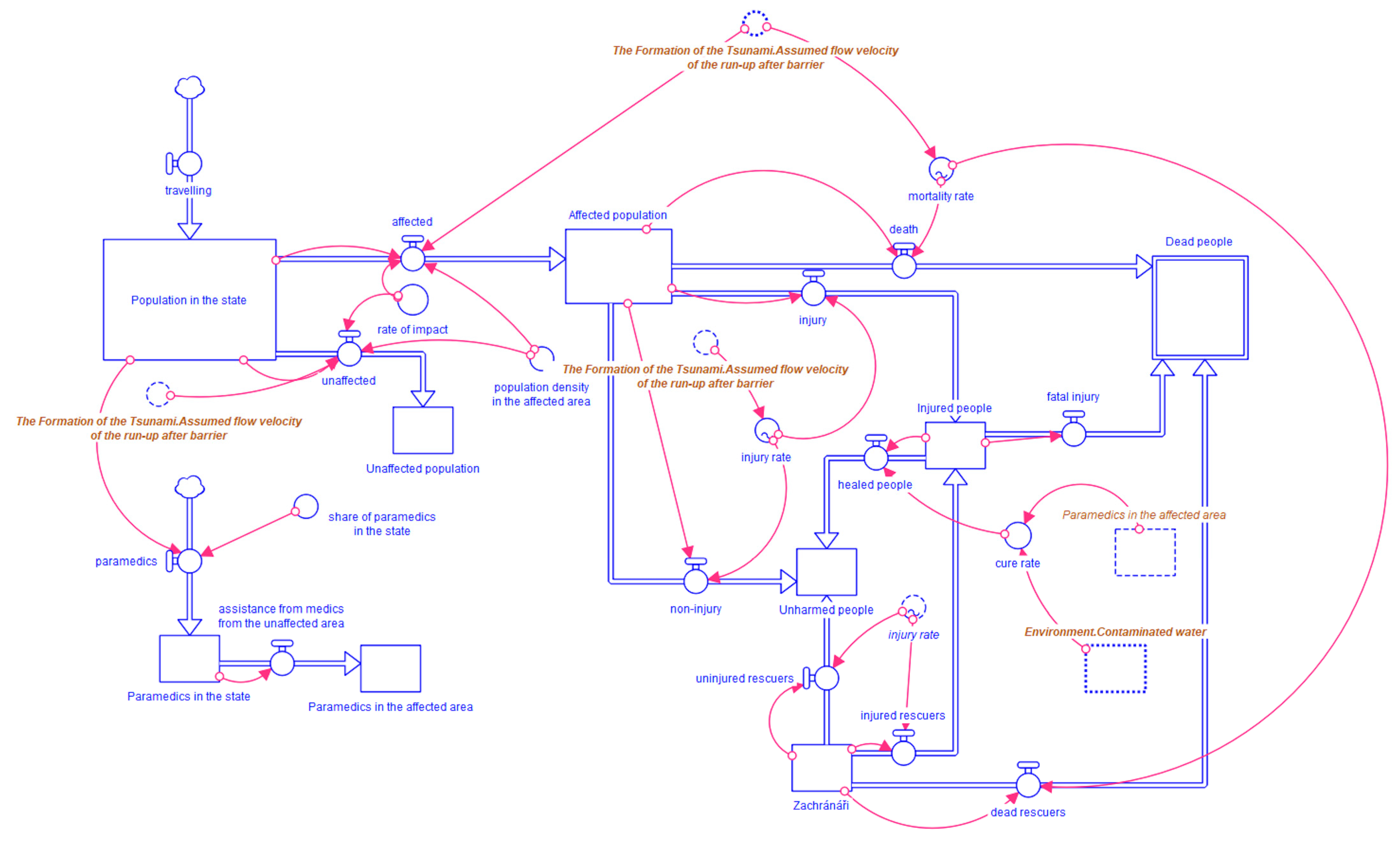
3.2.2. People
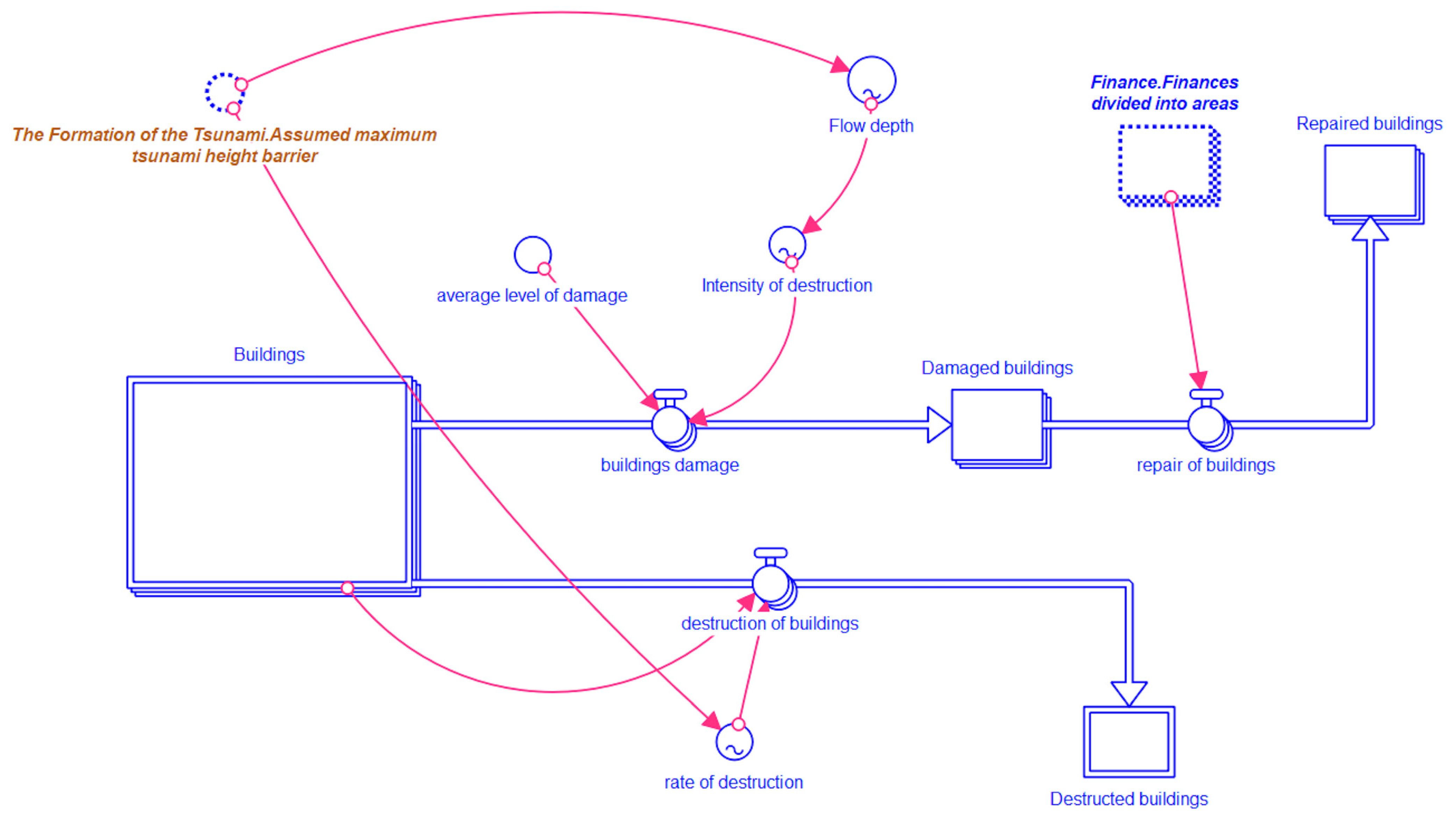
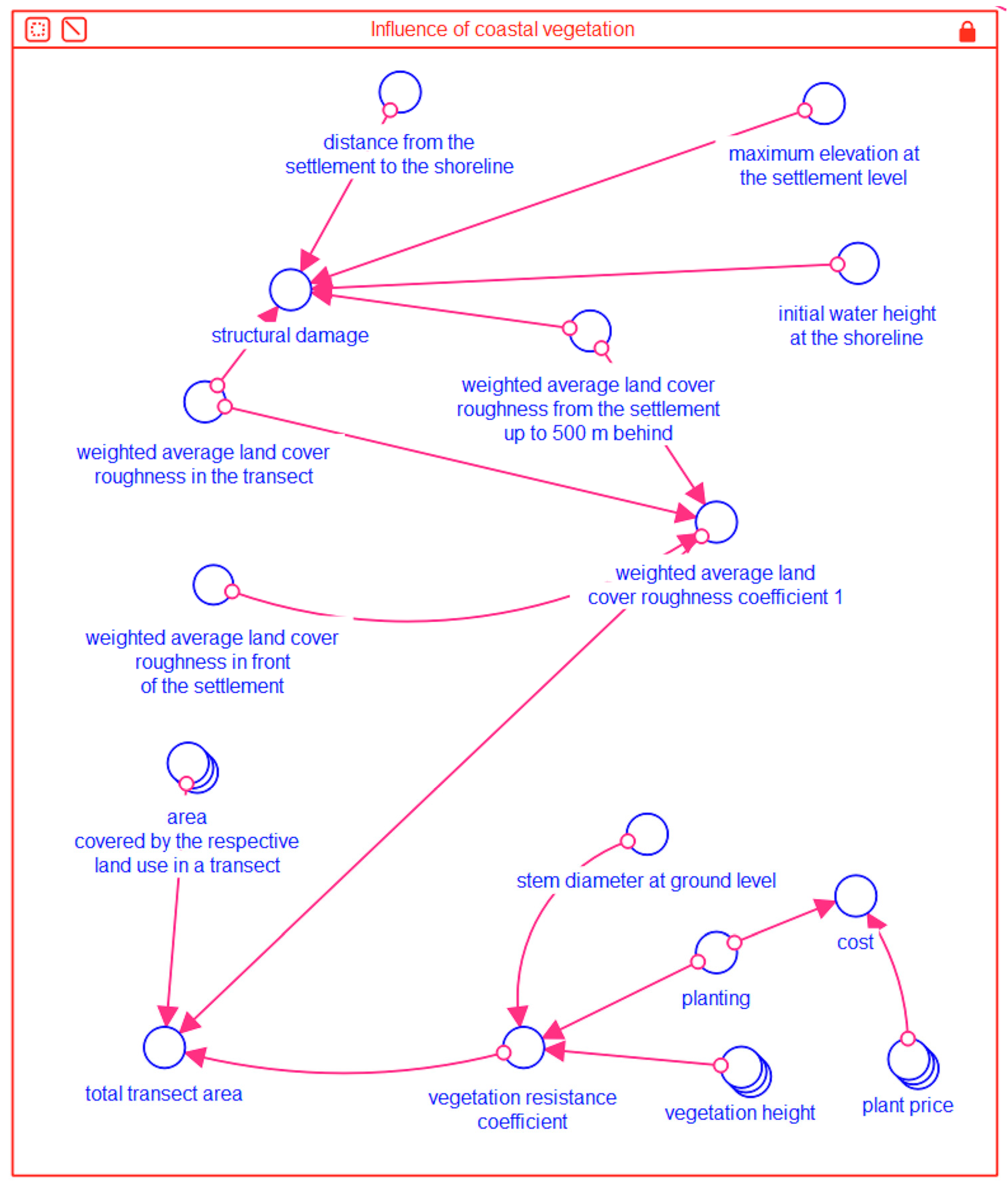
3.2.3. Buildings
- Array Types of building
- Wood and metal plates (180);
- Brick building (550);
- Larger reinforced brick buildings (90);
- Buildings with unreinforced concrete structures (63);
- Buildings with reinforced concrete structures (27).
- Array Damage
- Slight damage to the roof and furniture;
- Medium damage to walls and windows;
- Construction damage;
- Extreme construction damage.
3.2.4. Infrastructure
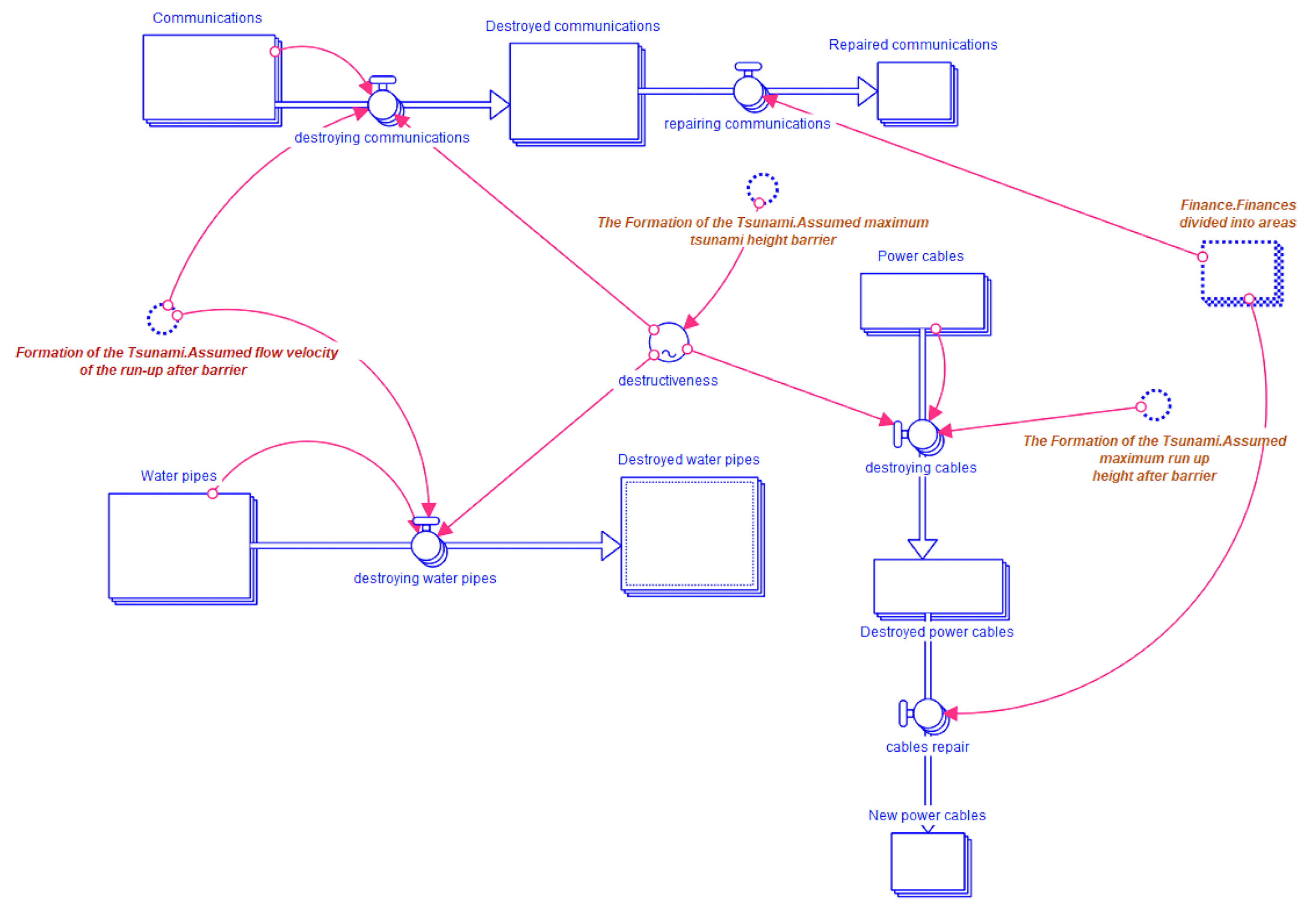
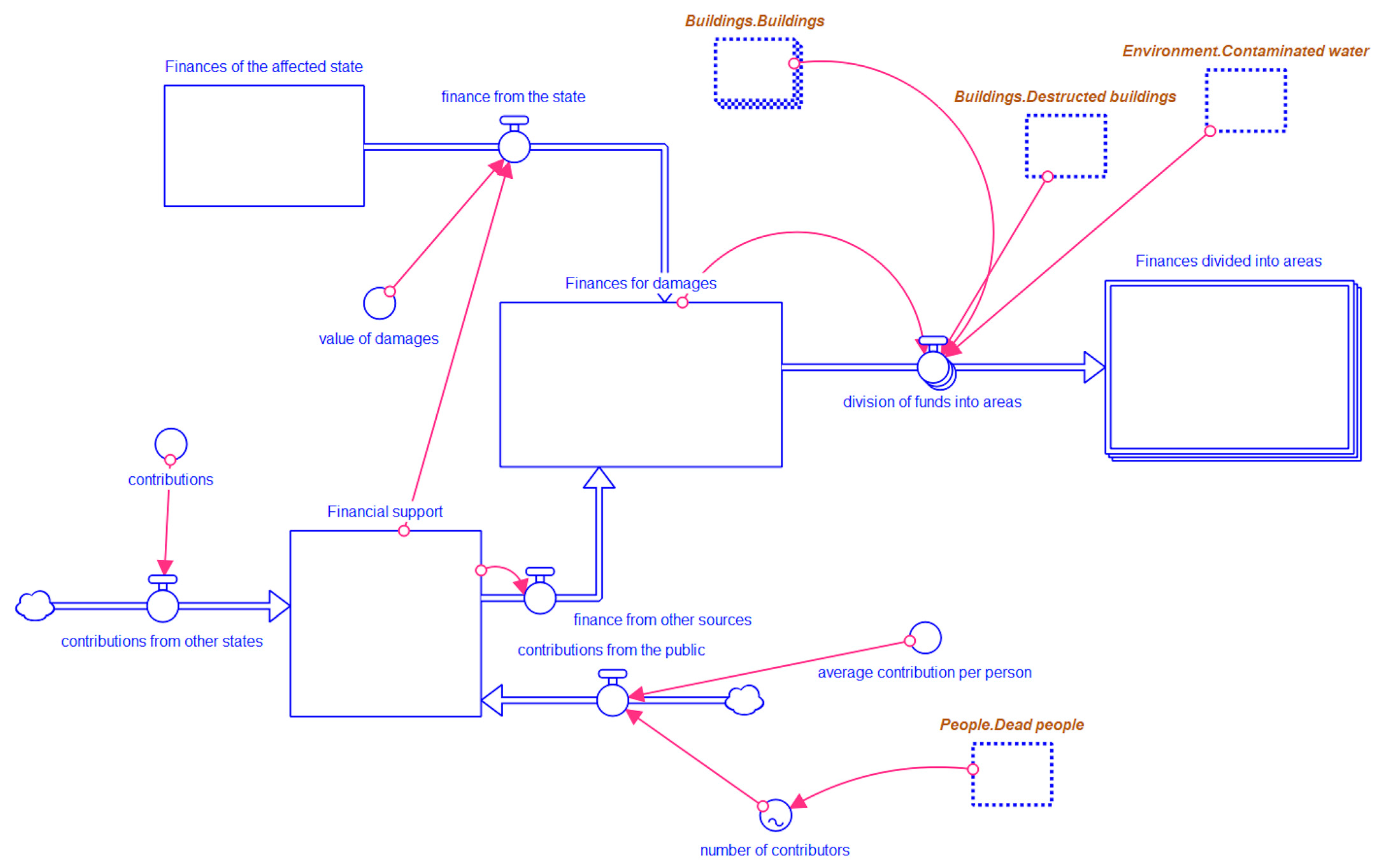
3.2.5. Finance
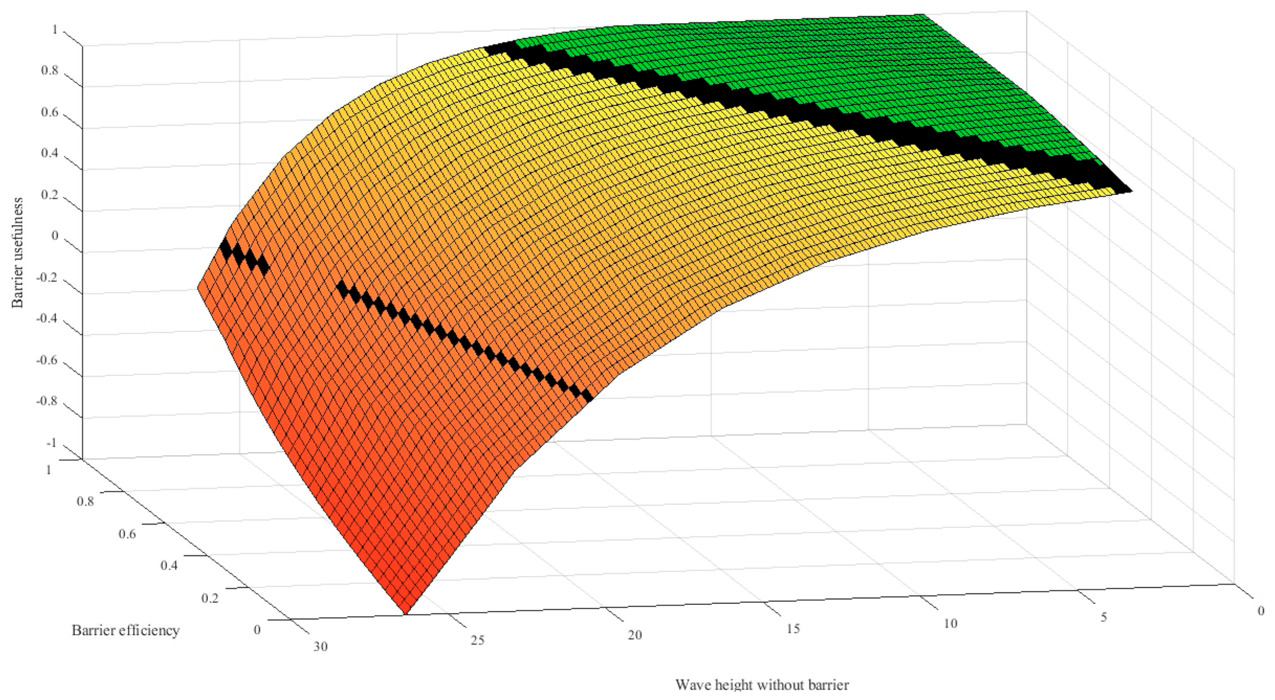
3.2.6. Defense Elements
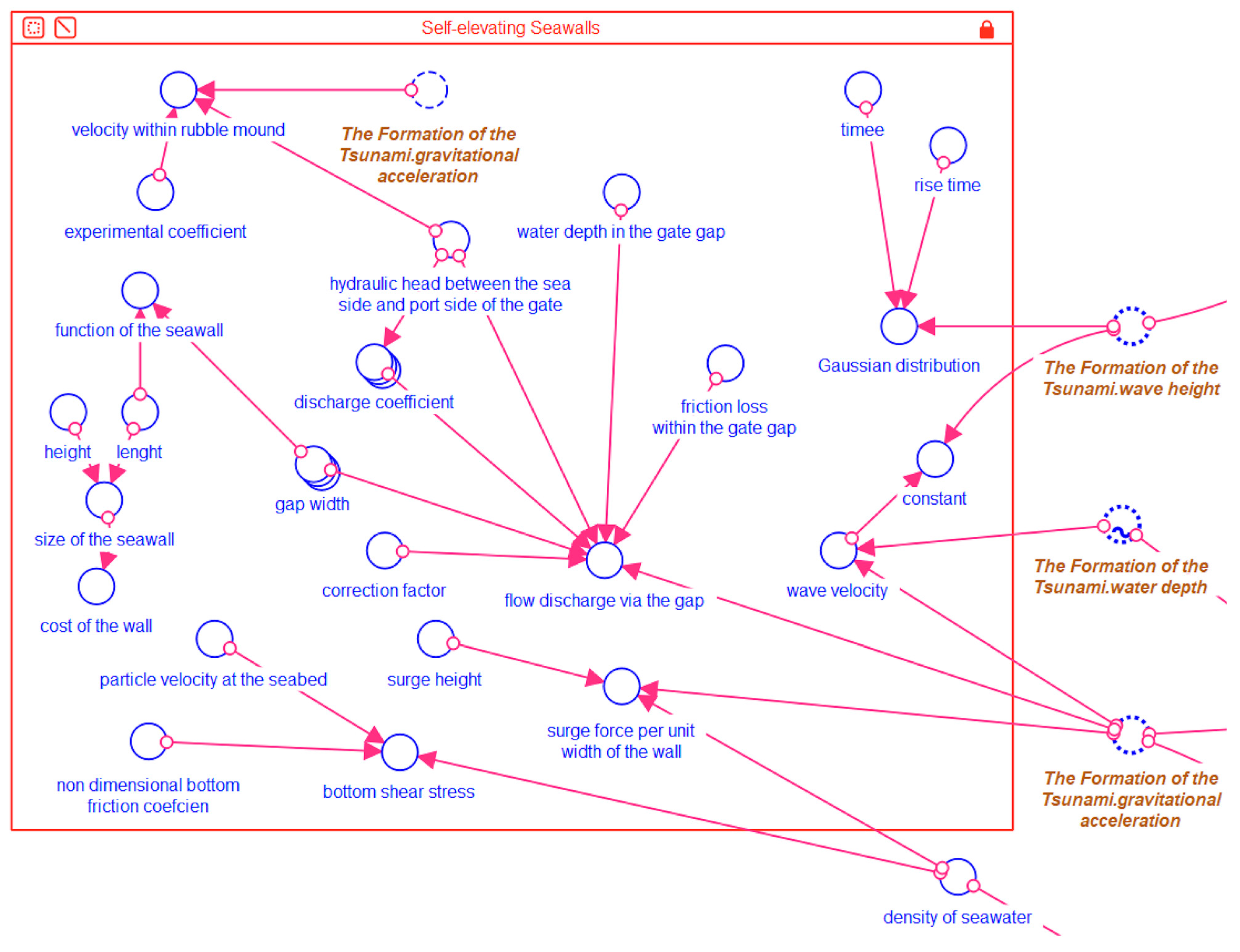
- Self-elevating Seawalls
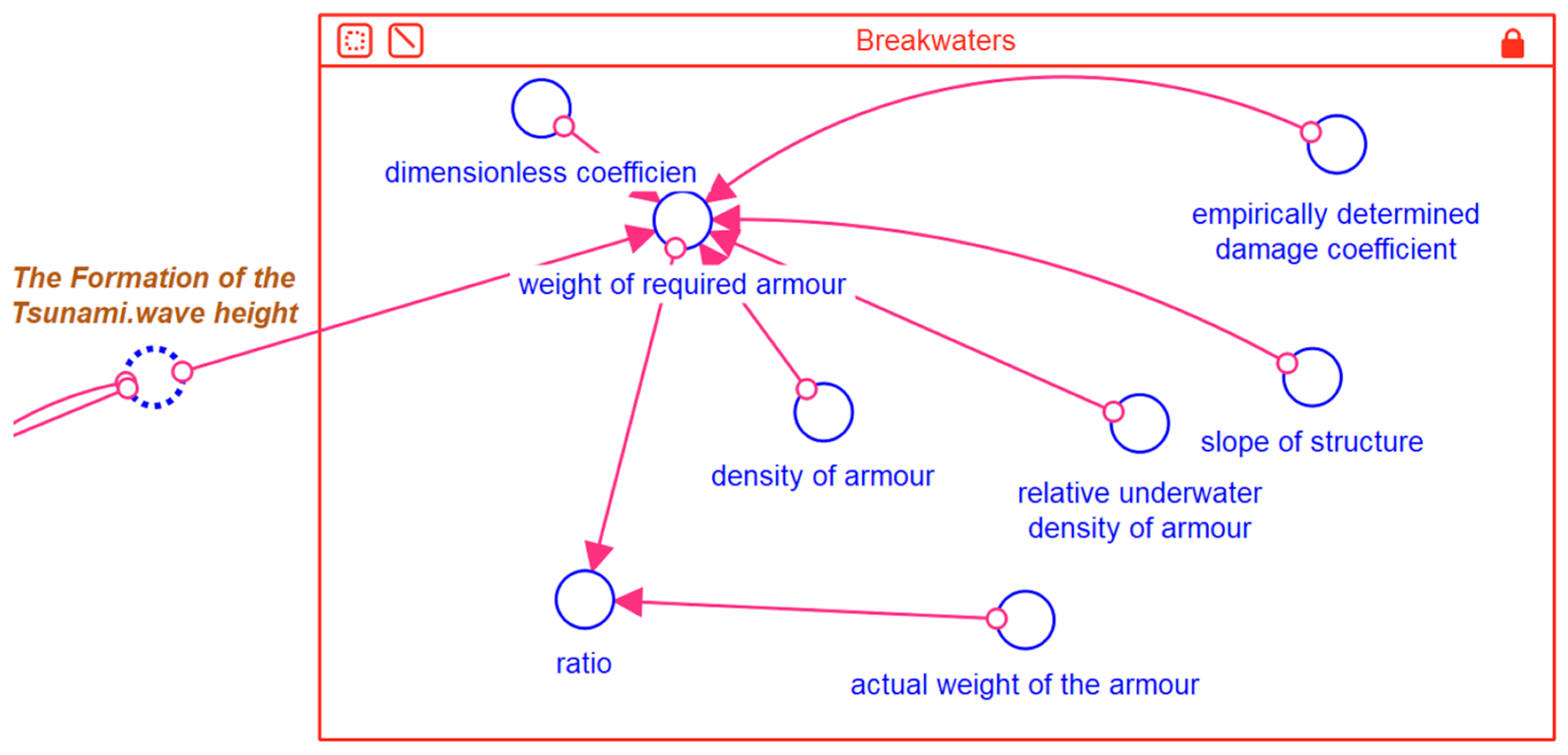
- Breakwaters
- Vertical deep barrier
- Other defense alternatives
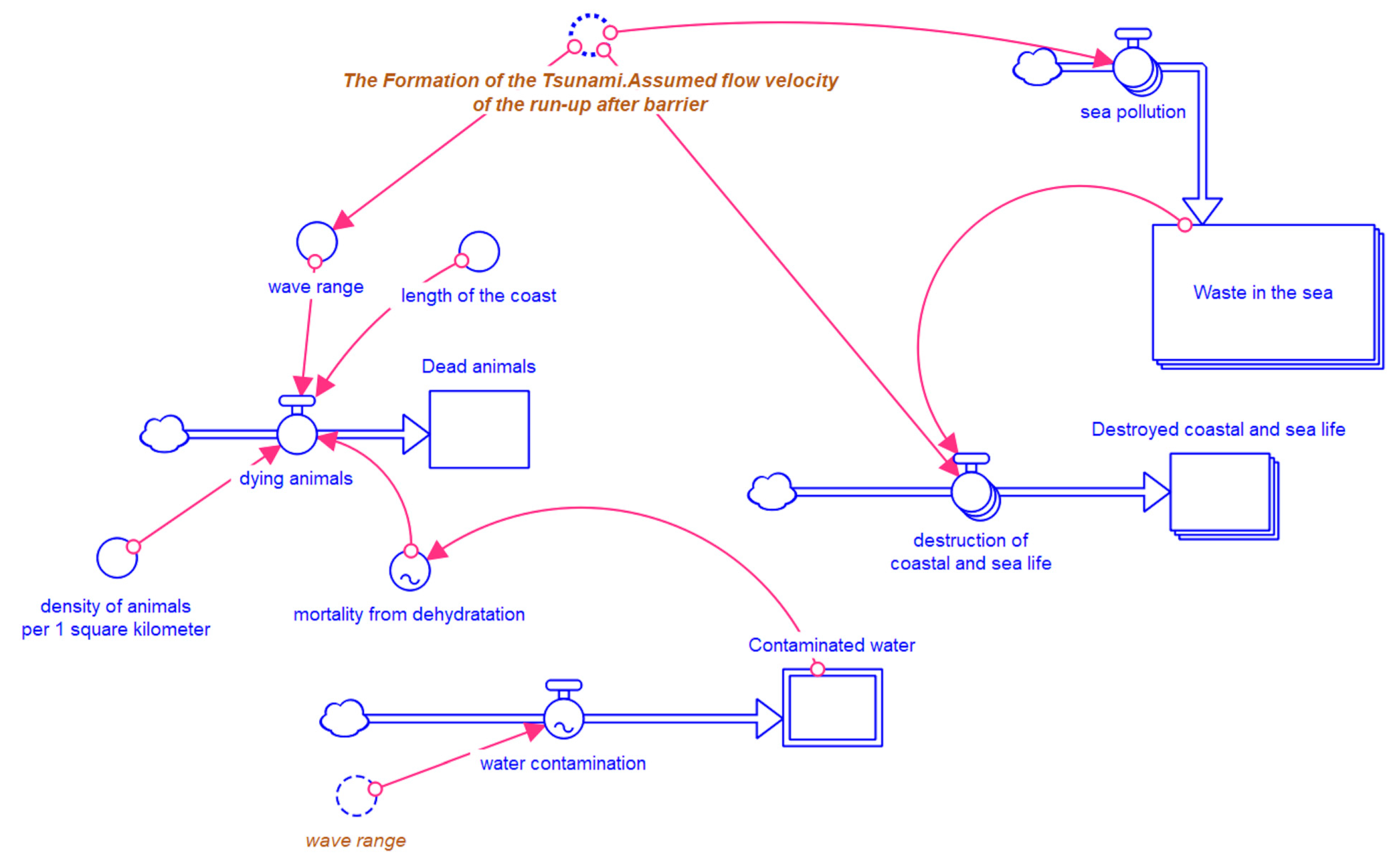
3.2.7. Environment
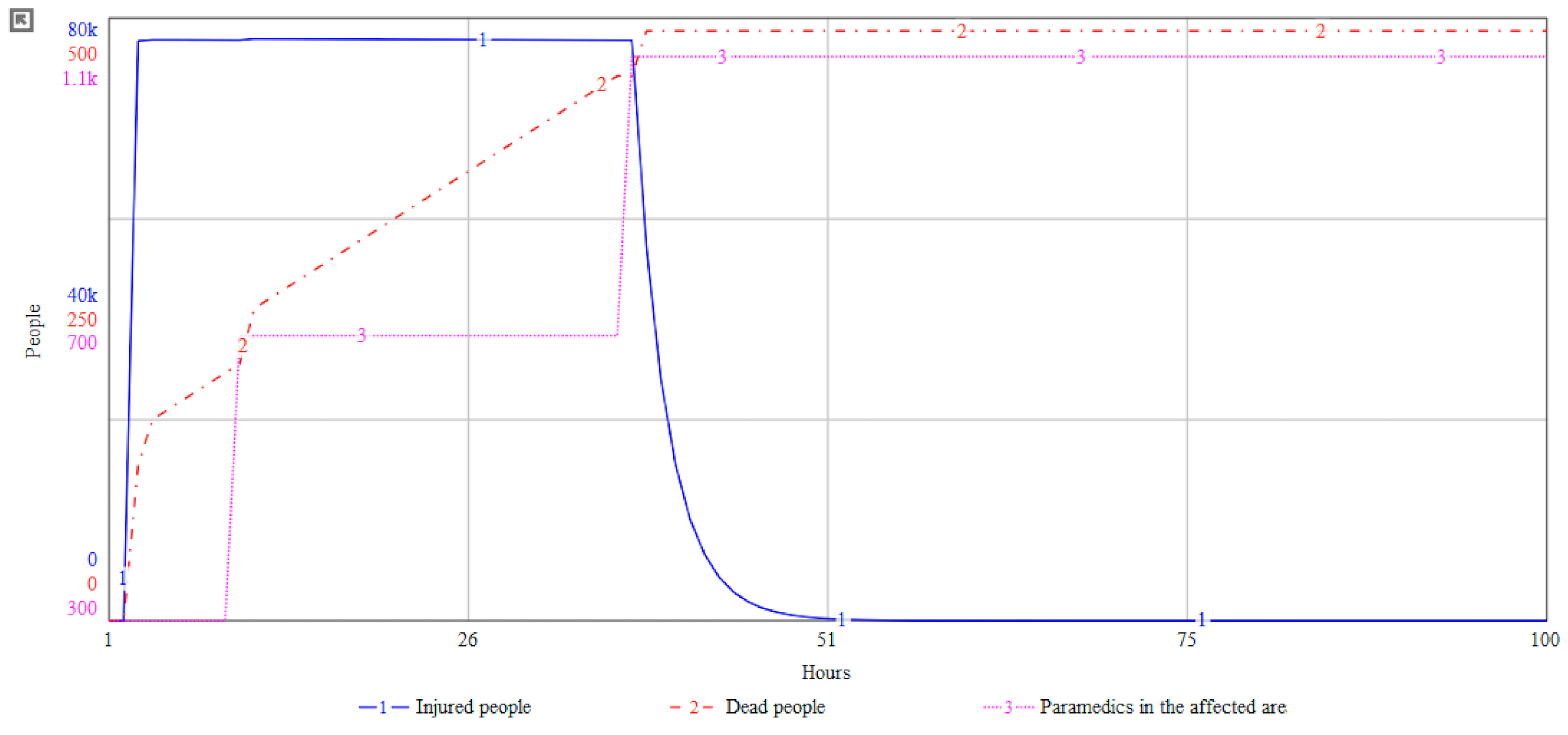
3.2.8. Model Simulation
4. Study Limitations
5. Conclusions
Author Contributions
Funding
Institutional Review Board Statement
Informed Consent Statement
Data Availability Statement
Acknowledgments
Conflicts of Interest
Appendix A
| Tool | Website | Usage | In Total |
|---|---|---|---|
| Agisoft | https://www.agisoft.com/, accessed on 15 March 2023 | For photogrammetric process; for image post-processing | 3 |
| Agisoft Metashape is a stand-alone software product that performs photogrammetric processing of digital images and generates 3D spatial data to be used in GIS applications, cultural heritage documentation, and visual effects production, as well as for indirect measurements of objects of various scales. | |||
| Amira | https://www.thermofisher.com/cz/en/home/electron-microscopy/products/software-em-3d-vis/amira-software.html, accessed on 15 March 2023 | Tsunami waves visualization | 1 |
| Amira Software is a comprehensive and versatile 2D–5D solution for visualizing, analyzing, and understanding life science and biomedical research data from many image modalities, including Optical and Electron Microscopy, CT, MRI, and other imaging techniques. With incredible speed and flexibility, Amira Software supports advanced 2D–5D bioimaging workflows in research areas ranging from structural and cellular biology to tissue imaging, neuroscience, preclinical imaging, and bioengineering. From any 3D image data, including time series and multi-channel, Amira Software delivers a comprehensive range of data visualization, processing, and analysis capabilities. Amira Software allows life science and biomedical researchers to gain invaluable insights into their data at different scales and from any modality. | |||
| ANSYS | https://www.ansys.com/, accessed on 15 March 2023 | Modeling and validation of numerical models; to build numerical model; to build a channel domain | 5 |
| Ansys Discovery is the first simulation-driven design tool to combine instant physics simulation, proven Ansys high-fidelity simulation, and interactive geometry modeling in a single user experience. | |||
| ArcGIS | https://www.ArcGIS.com/index.html, accessed on 15 March 2023 | To identify blocks; for merging and checking data; for calculation of slope gradient; for evacuation potential; to plot a tectonic map; to subtract backscatter and seismic data, the post-slide bathymetry grid; to create map of studied area; for incorporating collected data; to model wave heights and inundation for a range of SLR scenarios | 15 |
| ArcGIS offers unique capabilities and flexible licensing for applying location-based analytics to your business practices. Gain greater insights using contextual tools to visualize and analyze your data. Collaborate and share via maps, apps, dashboards, and reports. | |||
| CALIB | http://calib.org/calib/, accessed on 15 March 2023 | To calibrate radiocarbon ages | 12 |
| Without official description | |||
| COMCOT | https://citeseerx.ist.psu.edu/viewdoc/download?doi=10.1.1.512.84&rep=rep1&type=pdf, accessed on 15 March 2023 Note: We could not find official website; included link is to manual for COMCOT software | NSWE solver; to simulate the entire life-span of a tsunami; to simulate tsunami propagation from its origin to coastal areas; to simulate tsunami events; for the wave propagation; to validate combination of time step, grid spacing, and depth | 9 |
| COMCOT (Cornell Multi-grid Coupled Tsunami model) adopts explicit staggered leap-frog finite difference schemes to solve Shallow Water Equations in both Spherical and Cartesian Coordinates. A nested grid system, dynamically coupled up to 12 levels (which will also be referred to as layers) with different grid resolutions, can be implemented in the model to fulfill the need for tsunami simulations in different scales. | |||
| Delft3D | https://oss.deltares.nl/web/delft3d, accessed on 15 March 2023 | To create a grid; to simulate tsunami; to model wave heights and inundation for a range of SLR scenarios | 4 |
| Delft3D is open-source software and facilitates the hydrodynamic (Delft3D-FLOW module), morphodynamic (Delft3D-MOR module), waves (Delft3D-WAVE module), water quality (Delft3D-WAQ module including the DELWAQ kernel), and particle (Delft3D-PART module) modeling. | |||
| DSAS | https://www.usgs.gov/centers/whcmsc/science/digital-shoreline-analysis-system-dsas?qt-science_center_objects=0#qt-science_center_objects, accessed on 15 March 2023 | Determination of coastline change | 1 |
| The Digital Shoreline Analysis System (DSAS) v5.0 software is an add-in to Esri ArcGIS desktop 10.4–10.6 that enables a user to calculate rate-of-change statistics from multiple historical shoreline positions. It provides an automated method for establishing measurement locations, performs rate calculations, provides the statistical data necessary to assess the robustness of the rates, and includes a beta model of shoreline forecasting with the option to generate 10- and/or 20-year shoreline horizons and uncertainty bands. | |||
| Fledermaus | https://qps.nl/fledermaus/, accessed on 15 March 2023 | For digital elevation models | 1 |
| Fledermaus unlocks the potential of data, with a wide variety of analysis tools working in 3D or 4D space. With fast and easy presentation tools, it shows data better than ever before. | |||
| FLOW3D | https://www.flow3d.com/, accessed on 15 March 2023 | Simulate tsunami | 1 |
| FLOW-3D is an accurate, fast, proven CFD software that solves the toughest free-surface flow problems. A pioneer in the CFD industry and a trusted leader, FLOW-3D is a highly efficient, comprehensive solution for free-surface flow problems with human-centric support. | |||
| Gambit | http://geoweb.mit.edu/gg/, accessed on 15 March 2023 | To generate geometry and meshes of the numerical model | 1 |
| GAMIT, GLOBK, and TRACK form a comprehensive suite of programs for analyzing GNSS measurements primarily to study crustal deformation. The software has been developed by MIT, Scripps Institution of Oceanography, and Harvard University with support from the National Science Foundation. The software may be obtained without written agreement or royalty fee by universities and government agencies for any non-commercial purposes. | |||
| GeoClaw | http://www.clawpack.org/geoclaw, accessed on 15 March 2023 | To model tsunami; to simulate tsunami | 5 |
| It is a variant of Clawpack for geophysical flows. Clawpack is a collection of finite volume methods for linear and nonlinear hyperbolic systems of conservation laws. Clawpack employs high-resolution Godunov-type methods with limiters in a general framework applicable to many kinds of waves. Clawpack is written in Fortran and Python. | |||
| Geosoft Oasis | https://www.seequent.com/products-solutions/geosoft-oasis-montaj/, accessed on 15 March 2023 | To create color surface plot from simulation results | 1 |
| QA/QC, transform, and analyze all raw data—geology, geochemistry, and geophysics—with powerful 2D and 3D modeling capabilities. | |||
| Geowave | https://www.osgeo.org/projects/geowave/, accessed on 15 March 2023 | To generate tsunami and wave propagation | 1 |
| GeoWave is a software library that connects the scalability of distributed computing frameworks and key-value stores with modern geospatial software to store, retrieve, and analyze massive geospatial datasets. | |||
| HAZUS | https://www.fema.gov/flood-maps/products-tools/hazus, accessed on 15 March 2023 | To define building damage states | 1 |
| FEMA’s Hazus Program provides standardized tools and data for estimating risk from earthquakes, floods, tsunamis, and hurricanes. Hazus models combine expertise from many disciplines to create actionable risk information that increases community resilience. Hazus software is distributed as a GIS-based desktop application with a growing collection of simplified open-source tools. Risk assessment resources from the Hazus program are always freely available and transparently developed. | |||
| HydroSed2D | https://sourceforge.net/projects/hydrosed2d/, accessed on 15 March 2023 | To investigate tsunami wave run-up and land inundation on coastal beaches | 1 |
| HydroSed2D is a two-dimensional numerical model for hydrodynamics and sediment transport on unstructured mesh. | |||
| ICEM | https://www.3ds.com/products-services/catia/products/icem-surf/, accessed on 15 March 2023 | Mesh generation | 1 |
| ICEM Surf is the industry-leading Curve and Surface explicit geometry modeling tool for defining, analyzing, and performing high-end visualization of complex free-form shape CAD surface models to the highest quality. Used in product design processes throughout automotive, aerospace, consumer goods, and press-tool design industries, providing solutions for direct surface modeling, refinement, reconstruction, and scan modeling. | |||
| MATLAB | https://www.mathworks.com/products/matlab.html, accessed on 15 March 2023 | To solve the eigenvalue problem; to compare results and estimate; to compute wind-driven flow; to classify pre- and post-tsunami images; to simulate time steps; to export and reformate grid; to perform gradient-based optimization algorithm; to process data; to solve part of the system | 15 |
| MATLAB® combines a desktop environment tuned for iterative analysis and design processes with a programming language that expresses matrix and array mathematics directly. It includes the Live Editor for creating scripts that combine code, output, and formatted text in an executable notebook. | |||
| MB-System | https://www.mbari.org/products/research-software/mb-system/, accessed on 15 March 2023 | To calculate seafloor attributes; to generate the one-ninth arc-second coastal DEM | 2 |
| MB-System is an open-source software package for the processing and display of bathymetry and backscatter imagery data derived from multibeam, interferometry, and sidescan sonars. | |||
| OpenFOAM | https://www.openfoam.com/, accessed on 15 March 2023 | To develop a nonlinear three-dimensional coupled model; to create 3D model; to use its solver; to calculate the flow field under the water surface; to create model of 3D numerical wave tank; to create model of tsunami barriers and tsunami impacts; to create a hydrodynamic and morphologic model; to create tsunami model; to simulate tsunami; to calculate properties of tsunami | 25 |
| OpenFOAM is the free, open-source CFD software developed primarily by OpenCFD Ltd. since 2004. It has a large user base across most areas of engineering and science, from both commercial and academic organizations. OpenFOAM has an extensive range of features to solve anything from complex fluid flows involving chemical reactions, turbulence, and heat transfer to acoustics, solid mechanics, and electromagnetics. | |||
| OsiriX DICOM | https://www.osirix-viewer.com/, accessed on 15 March 2023 | To construct a 3D image of stones and to measure its dimensions, volume, and surface area | 1 |
| It fully supports the DICOM standard for easy integration in your workflow environment and an open platform for the development of processing tools. It offers advanced post-processing techniques in 2D and 3D, exclusive innovative techniques for 3D and 4D navigation, and a complete integration with any PACS. | |||
| QGIS | https://qgis.org/en/site/, accessed on 15 March 2023 | To create a map; to generate mesh | 3 |
| QGIS is a professional GIS application that is built on top of and proud to be itself Free and Open-Source Software (FOSS). | |||
| R-studio | https://www.rstudio.com/, accessed on 15 March 2023 | To calibrate ages of tsunami deposits | 1 |
| RStudio’s mission is to create free and open-source software for data science, scientific research, and technical communication. We do this to enhance the production and consumption of knowledge by everyone, regardless of economic means, and to facilitate collaboration and reproducible research, both of which are critical to the integrity and efficacy of work in science, education, government, and industry. | |||
| reflexW | https://www.sandmeier-geo.de/reflexw.html, accessed on 15 March 2023 | To process Ground-Penetrating Radar data | 1 |
| he software covers the complete range of wave data (seismic, GPR, ultrasound) and the different geometry assemblings (surface reflection and refraction, borehole crosshole and tomography, and combination of borehole and surface measurements). You may also have a look at a one-sided brochure for GPR, reflections seismics, refraction seismics, and borehole application. | |||
| SPAD | https://ia-data-analytics.com/data-mining-software/, accessed on 15 March 2023 | To apply statistical test on data | 1 |
| Coheris Analytics SPAD is the only software dedicated to Data Mining and Predictive analysis that provides a totally graphical and intuitive interface with powerful features. | |||
| tsunami-2d | https://www.ornl.gov/team/scale/sensitivity-and-uncertainty-analysis-0, accessed on 15 March 2023 | To apply sensitivity analysis and propagation of uncertainties of cross-sections; to conduct sensitivity and uncertainty analysis | 2 |
| The TSUNAMI-1D, TSUNAMI-2D, and TSUNAMI-3D analysis sequences compute the sensitivity of keff and reaction rates to energy-dependent cross-section data for each reaction of each nuclide in a system model. The one-dimensional (1D) transport calculations are performed with XSDRNPM, the two-dimensional (2D) transport calculations are performed using NEWT, and the three-dimensional (3D) calculations are performed with KENO V.a or KENO-VI. | |||
| VOLNA | https://gmd.copernicus.org/articles/11/4621/2018/, accessed on 15 March 2023 | To compare results with presented numerical solver; to simulate tsunami | 2 |
| A finite-volume nonlinear shallow water equation (NSWE) solver built on the OP2 domain-specific language (DSL) for unstructured mesh computations. VOLNA-OP2 is unique among tsunami solvers in its support for several high-performance computing platforms: central processing units (CPUs), the Intel Xeon Phi, and graphics processing units (GPUs). | |||
| Abb. | Method | Usage |
|---|---|---|
| AMS | Accelerator Mass Spectrometry | To obtain radiocarbon ages |
| CFD | Computational Fluid Dynamics | As a part of OpenFOAM; model of FLOW3D; to solve a three-dimensional Reynolds Averaged Navier–Stokes equations; to investigate solitary wave-induced vertical and horizontal forces on coastal bridges; to predict flow character and dynamic loading profile from an idealized tsunami impact on a coastal community; to simulate impulse wave generation and propagation; to simulate a tsunami |
| CRS | Constant Rate of Supply method | To develop dates of tsunami deposits |
| DEM | Digital Elevation Models | To capture a shielding phenomenon created by the dense buildings; to generate images; for topographical data; to calculate finite difference grid; to calculate a bathymetry and derived seafloor attributes such as slope gradient; to evaluate a model; to generate an inundation zones |
| FAM | Finite Area Method | To address the problem of fluid information mapped from the three-dimensional space to the two-dimensional space |
| FCM | Fuzzy C-Means Clustering | As part of used method |
| FEM | Finite Element Mesh | To create a mesh |
| FFT | Fast Fourier Transform | To analyze data; to obtain value for equations |
| FVCF | Finite Volume with Characteristic Flux | As part of equations |
| FVM | Finite Volume Method | To compute the two-phase incompressible flow with the Navier–Stokes equations; as a solver; as a part of model |
| GKS | Gustafsson–Kreiss–Sundström stability theory | To evaluate penalization |
| GPR | Ground-Penetrating Radar | For characterizing the subsurface subsidence structure associated with sinkholes and reconstructing their deformational and tsunami deposit history; to trace extent and morphology |
| LSWE | Linear Shallow Water Equations | As a part of COMCOT; to calculate a tsunami |
| MAP | Maximum a Posteriori Values | To calculate an estimate of the maximum water surface elevation standard deviation; to characterize solution of the problem |
| MC | Monte Carlo | To combine a probability of occurrence of earthquake; to estimate a relative error; to evaluate an overall uncertainty in tsunami hazard; to generate a synthetic earthquake catalog; to sample a resulting posterior; to confirm robustness of the created index; to vary all uncertain input parameters have been randomly within the specified distribution |
| MOST | Method for Splitting Tsunamis | To simulate a tsunami; to simulate an earthquake-generated tsunami |
| MULES | Multidimensional Universal Limiter for Explicit Solution | To maintain boundedness of a volume fraction; to maintain boundedness of a volume fraction independent of the underlying numerical scheme, mesh structure, etc. |
| NSWE | Nonlinear Shallow Water Equations | To calculate a long wave propagation; to simulate protection of small islands; as a base for modified equations; as a governing equation; to describe a propagation problem; to perform numerical simulations of volcanic explosion resulting in a tsunami wave traveling across the water; to solve tsunami equations |
| PCA | Principal Component Analysis | For a dimensionality reduction; to select relevant variables |
| PIMPLE | Pressure Implicit with Splitting of Operator | For a pressure-velocity solver; to employ a pressure-velocity solver To solve a velocity and pressure |
| PISO | Pressure Implicit with Splitting of Operators | To obtain a pressure field; to solve RANS equations with a volume of fluid |
| PTHA | Probabilistic Tsunami Hazard Analysis | As based method for expanded method; for modeling a tsunami |
| SIMPLE | Semi-Implicit Method for Pres-sure-Linked Equations | As a part of PIMPLE |
| SPH | Smoothed Particle Hydrodynamics | As a based method for enchanted method; for wave propagation from off- to onshore; to simulate waves; to study the nature of flows for an extreme wave above and in the interior of gravel bedforms |
| SWE | Shallow Water Equations | As a base for a model; for modeling a tsunami with small numbers of observation points in more physically realistic settings; to calculate a model |
| VOF | Volume of Fluid | To capture a free surface; to obtain sea-level or mudslide interface location; to figure out the role of vegetation of finite width in energy reduction of flood flow; to track the free surface between two fluids |
| Agisoft | Amira | ANSYS | ArcGIS | CALIB | COMCOT | Delft3D | DSAS | Fledermaus | FLOW3D | Gambit | GeoClaw | Geowave | HAZUS | HydroSed2D | ICEM | MATLAB | MB-System | OpenFOAM | OsiriX DICOM | Qgis | R-studio | reflexW | SPAD | tsunami-2d | VOLNA | Total | |
|---|---|---|---|---|---|---|---|---|---|---|---|---|---|---|---|---|---|---|---|---|---|---|---|---|---|---|---|
| Applications Geosciences, Multidisciplinary | 0 | 0 | 0 | 0 | 0 | 0 | 0 | 0 | 0 | 0 | 0 | 0 | 0 | 0 | 1 | 0 | 0 | 0 | 0 | 0 | 0 | 0 | 0 | 0 | 0 | 0 | 1 |
| Computer Science, Interdisciplinary | 0 | 0 | 0 | 0 | 0 | 0 | 0 | 0 | 0 | 0 | 0 | 1 | 0 | 0 | 1 | 0 | 0 | 0 | 0 | 0 | 0 | 0 | 0 | 0 | 0 | 0 | 2 |
| Computer Science, Theory, and Methods | 0 | 0 | 0 | 0 | 0 | 0 | 0 | 0 | 0 | 0 | 0 | 0 | 0 | 0 | 0 | 0 | 1 | 0 | 0 | 0 | 0 | 0 | 0 | 0 | 0 | 0 | 1 |
| Engineering, Civil | 0 | 0 | 3 | 1 | 0 | 1 | 1 | 0 | 0 | 0 | 0 | 0 | 0 | 1 | 0 | 0 | 3 | 0 | 10 | 0 | 1 | 0 | 0 | 0 | 0 | 0 | 21 |
| Engineering, Environmental | 0 | 0 | 0 | 1 | 0 | 0 | 0 | 0 | 0 | 0 | 0 | 0 | 0 | 0 | 0 | 0 | 0 | 0 | 1 | 0 | 0 | 0 | 0 | 0 | 0 | 0 | 2 |
| Engineering, Geological | 1 | 0 | 0 | 2 | 0 | 0 | 0 | 0 | 0 | 0 | 1 | 0 | 0 | 0 | 0 | 0 | 0 | 0 | 0 | 0 | 0 | 0 | 0 | 0 | 0 | 0 | 4 |
| Engineering, Marine | 0 | 0 | 2 | 0 | 0 | 0 | 1 | 0 | 0 | 0 | 0 | 0 | 0 | 0 | 0 | 0 | 2 | 0 | 8 | 0 | 1 | 0 | 0 | 0 | 0 | 0 | 14 |
| Engineering, Mechanical | 0 | 0 | 0 | 0 | 0 | 0 | 0 | 0 | 0 | 0 | 0 | 0 | 0 | 0 | 0 | 1 | 0 | 0 | 2 | 0 | 0 | 0 | 0 | 0 | 0 | 0 | 3 |
| Engineering, Multidisciplinary | 3 | 0 | 1 | 0 | 0 | 0 | 0 | 0 | 0 | 0 | 0 | 0 | 0 | 0 | 0 | 1 | 1 | 0 | 2 | 0 | 0 | 0 | 0 | 0 | 0 | 0 | 8 |
| Engineering, Ocean | 0 | 0 | 2 | 1 | 0 | 1 | 2 | 0 | 0 | 0 | 0 | 0 | 0 | 1 | 0 | 0 | 4 | 0 | 16 | 0 | 1 | 0 | 0 | 0 | 0 | 0 | 28 |
| Environmental Sciences | 0 | 0 | 0 | 0 | 0 | 1 | 0 | 0 | 0 | 0 | 0 | 0 | 0 | 0 | 0 | 0 | 0 | 1 | 2 | 1 | 0 | 0 | 0 | 0 | 0 | 0 | 5 |
| Geography, Physical | 0 | 0 | 0 | 0 | 3 | 0 | 0 | 1 | 0 | 0 | 0 | 0 | 0 | 0 | 0 | 0 | 0 | 1 | 0 | 0 | 0 | 0 | 1 | 0 | 0 | 0 | 6 |
| Geochemistry and Geophysics | 0 | 0 | 0 | 0 | 1 | 3 | 0 | 0 | 0 | 0 | 0 | 1 | 0 | 0 | 0 | 0 | 3 | 0 | 0 | 0 | 0 | 0 | 0 | 0 | 0 | 0 | 8 |
| Geology | 0 | 0 | 0 | 0 | 2 | 0 | 0 | 0 | 0 | 0 | 0 | 0 | 0 | 0 | 0 | 0 | 0 | 0 | 0 | 0 | 0 | 1 | 0 | 0 | 0 | 0 | 3 |
| Geosciences, Multidisciplinary | 0 | 1 | 0 | 8 | 8 | 5 | 1 | 1 | 1 | 0 | 1 | 3 | 1 | 0 | 0 | 0 | 4 | 2 | 3 | 0 | 3 | 0 | 1 | 1 | 0 | 0 | 44 |
| Imaging Science and Photographic Technology | 0 | 0 | 0 | 0 | 0 | 0 | 0 | 0 | 0 | 0 | 0 | 0 | 0 | 0 | 0 | 0 | 0 | 0 | 0 | 0 | 1 | 0 | 0 | 0 | 0 | 0 | 1 |
| Materials Science, Multidisciplinary | 0 | 0 | 1 | 0 | 0 | 0 | 0 | 0 | 0 | 0 | 0 | 0 | 0 | 0 | 0 | 0 | 0 | 0 | 0 | 0 | 0 | 0 | 0 | 0 | 0 | 0 | 1 |
| Mathematics, Applied | 0 | 0 | 0 | 1 | 0 | 0 | 0 | 0 | 0 | 0 | 0 | 0 | 0 | 0 | 0 | 0 | 1 | 0 | 0 | 0 | 0 | 0 | 0 | 0 | 0 | 1 | 3 |
| Mathematics, Interdisciplinary Applications | 0 | 0 | 0 | 0 | 0 | 0 | 0 | 0 | 0 | 0 | 0 | 0 | 0 | 0 | 0 | 0 | 1 | 0 | 1 | 0 | 0 | 0 | 0 | 0 | 0 | 0 | 2 |
| Mechanics | 0 | 0 | 1 | 0 | 0 | 0 | 0 | 0 | 0 | 0 | 0 | 0 | 0 | 0 | 0 | 1 | 1 | 0 | 2 | 0 | 0 | 0 | 0 | 0 | 0 | 0 | 5 |
| Meteorology and Atmospheric Sciences | 0 | 0 | 0 | 3 | 1 | 3 | 1 | 0 | 0 | 0 | 0 | 1 | 1 | 0 | 0 | 0 | 2 | 0 | 3 | 0 | 0 | 0 | 0 | 1 | 0 | 0 | 16 |
| Multidisciplinary Sciences | 0 | 0 | 0 | 2 | 1 | 0 | 1 | 0 | 0 | 0 | 0 | 0 | 0 | 0 | 0 | 0 | 0 | 0 | 0 | 0 | 1 | 0 | 0 | 0 | 0 | 1 | 6 |
| Nuclear Science and Technology | 0 | 0 | 0 | 0 | 0 | 0 | 0 | 0 | 0 | 0 | 0 | 0 | 0 | 0 | 0 | 0 | 0 | 0 | 0 | 0 | 0 | 0 | 0 | 0 | 1 | 0 | 1 |
| Oceanography | 2 | 0 | 2 | 5 | 3 | 1 | 1 | 0 | 1 | 1 | 0 | 1 | 0 | 0 | 0 | 0 | 3 | 1 | 8 | 0 | 1 | 0 | 0 | 0 | 1 | 0 | 31 |
| Physics, Fluids, and Plasmas | 0 | 0 | 1 | 0 | 0 | 0 | 0 | 0 | 0 | 0 | 0 | 0 | 0 | 0 | 0 | 0 | 0 | 0 | 1 | 0 | 0 | 0 | 0 | 0 | 0 | 0 | 2 |
| Physics, Mathematical | 0 | 0 | 0 | 0 | 0 | 0 | 0 | 0 | 0 | 0 | 0 | 0 | 0 | 0 | 0 | 0 | 1 | 0 | 0 | 0 | 0 | 0 | 0 | 0 | 0 | 0 | 1 |
| Remote Sensing | 0 | 0 | 0 | 0 | 0 | 0 | 0 | 0 | 0 | 0 | 0 | 0 | 0 | 0 | 0 | 0 | 0 | 0 | 0 | 0 | 1 | 0 | 0 | 0 | 0 | 0 | 1 |
| Statistics and Probability | 0 | 0 | 0 | 0 | 0 | 0 | 0 | 0 | 0 | 0 | 0 | 0 | 0 | 0 | 0 | 0 | 1 | 0 | 0 | 0 | 0 | 0 | 0 | 0 | 0 | 0 | 1 |
| Water Resources | 0 | 0 | 0 | 4 | 1 | 3 | 1 | 0 | 0 | 0 | 0 | 1 | 1 | 0 | 0 | 0 | 1 | 0 | 6 | 0 | 1 | 0 | 0 | 1 | 0 | 0 | 20 |
| Total | 6 | 1 | 13 | 28 | 20 | 18 | 9 | 2 | 2 | 1 | 2 | 8 | 3 | 2 | 2 | 3 | 29 | 5 | 65 | 1 | 11 | 1 | 2 | 3 | 2 | 2 |
Appendix B. Module Formation of Tsunami: Equations
Appendix C. Module Defense Elements: Equations
References
- Frequently Asked Questions. Available online: http://itic.ioc-unesco.org/index.php?option=com_content&view=article&id=1133&Itemid=2155 (accessed on 1 July 2023).
- Nacházel, T.; Babič, F.; Baiguera, M.; Čech, P.; Husáková, M.; Mikulecký, P.; Mls, K.; Ponce, D.; Salmanidou, D.; Štekerová, K.; et al. Tsunami-Related Data: A Review of Available Repositories Used in Scientific Literature. Water 2021, 13, 2177. [Google Scholar] [CrossRef]
- Tappin, D.R. The Generation of Tsunamis. In Encyclopedia of Maritime and Offshore Engineering; Carlton, J., Jukes, P., Choo, Y.S., Eds.; John Wiley & Sons, Ltd.: Chichester, UK, 2017; pp. 1–10. ISBN 978-1-118-47635-2. [Google Scholar]
- Tsunamis. Available online: https://www.who.int/westernpacific/health-topics/tsunamis (accessed on 1 July 2023).
- Monecke, K.; Finger, W.; Klarer, D.; Kongko, W.; McAdoo, B.G.; Moore, A.L.; Sudrajat, S.U. A 1000-Year Sediment Record of Tsunami Recurrence in Northern Sumatra. Nature 2008, 455, 1232–1234. [Google Scholar] [CrossRef]
- Borrero, J.C. Field Survey of Northern Sumatra and Banda Aceh, Indonesia after the Tsunami and Earthquake of 26 December 2004. Seismol. Res. Lett. 2005, 76, 312–320. [Google Scholar] [CrossRef]
- Macías, J.; Castro, M.J.; Ortega, S.; Escalante, C.; González-Vida, J.M. Performance Benchmarking of Tsunami-HySEA Model for NTHMP’s Inundation Mapping Activities. Pure Appl. Geophys. 2017, 174, 3147–3183. [Google Scholar] [CrossRef]
- López-Venegas, A.M.; Horrillo, J.; Pampell-Manis, A.; Huérfano, V.; Mercado, A. Advanced Tsunami Numerical Simulations and Energy Considerations by Use of 3D–2D Coupled Models: The October 11, 1918, Mona Passage Tsunami. Pure Appl. Geophys. 2015, 172, 1679–1698. [Google Scholar] [CrossRef]
- Wendt, J.; Oglesby, D.D.; Geist, E.L. Tsunamis and Splay Fault Dynamics. Geophys. Res. Lett. 2009, 36. [Google Scholar] [CrossRef]
- Mulia, I.E.; Gusman, A.R.; Satake, K. Alternative to Non-Linear Model for Simulating Tsunami Inundation in Real-Time. Geophys. J. Int. 2018, 214, 2002–2013. [Google Scholar] [CrossRef]
- Arcos, M.E.M.; LeVeque, R.J. Validating Velocities in the GeoClaw Tsunami Model Using Observations near Hawaii from the 2011 Tohoku Tsunami. Pure Appl. Geophys. 2015, 172, 849–867. [Google Scholar] [CrossRef]
- Palupi, L.S. Psychological Preparedness for Disaster of Coastal Communities: A Systematic Review. IOP Conf. Ser. Earth Environ. Sci. 2021, 649, 012032. [Google Scholar] [CrossRef]
- Fernandez, A.; Black, J.; Jones, M.; Wilson, L.; Salvador-Carulla, L.; Astell-Burt, T.; Black, D. Flooding and Mental Health: A Systematic Mapping Review. PLoS ONE 2015, 10, e0119929. [Google Scholar] [CrossRef]
- PRISMA. The PRISMA 2020 Statement. Available online: https://www.bmj.com/lookup/doi/10.1136/bmj.n71 (accessed on 1 July 2023).
- Adobe. Available online: https://www.adobe.com/ (accessed on 1 July 2023).
- VOSviewer. Available online: https://www.vosviewer.com// (accessed on 1 July 2023).
- Williams, A.; Kennedy, S.; Philipp, F.; Whiteman, G. Systems Thinking: A Review of Sustainability Management Research. J. Clean. Prod. 2017, 148, 866–881. [Google Scholar] [CrossRef]
- Bureš, V.; Rácz, F. Identification of Sustainability Key Factors Based on Capturing Dominant Feedbacks of Behavioural Stereotypes in Socio-Economic Systems. Systems 2017, 5, 42. [Google Scholar] [CrossRef]
- Barlas, Y. Formal Aspects of Model Validity and Validation in System Dynamics. Syst. Dyn. Rev. 1996, 12, 183–210. [Google Scholar] [CrossRef]
- Liu, X.; Liu, C.; Zhu, X.; He, Y.; Wang, Q.; Wu, Z. 3D Modeling and Mechanism Analysis of Breaking Wave-Induced Seabed Scour around Monopile. Math. Probl. Eng. 2020, 2020, 1–17. [Google Scholar] [CrossRef]
- Qin, X.; Motley, M.; LeVeque, R.; Gonzalez, F.; Mueller, K. A Comparison of a Two-Dimensional Depth-Averaged Flow Model and a Three-Dimensional RANS Model for Predicting Tsunami Inundation and Fluid Forces. Nat. Hazards Earth Syst. Sci. 2018, 18, 2489–2506. [Google Scholar] [CrossRef]
- Autret, R.; Dodet, G.; Fichaut, B.; Suanez, S.; David, L.; Leckler, F.; Ardhuin, F.; Ammann, J.; Grandjean, P.; Allemand, P.; et al. A Comprehensive Hydro-Geomorphic Study of Cliff-Top Storm Deposits on Banneg Island during Winter 2013–2014. Mar. Geol. 2016, 382, 37–55. [Google Scholar] [CrossRef]
- Xiong, Y.; Liang, Q.; Park, H.; Cox, D.; Wang, G. A Deterministic Approach for Assessing Tsunami-Induced Building Damage through Quantification of Hydrodynamic Forces. Coast. Eng. 2019, 144, 1–14. [Google Scholar] [CrossRef]
- Bellotti, G. A Modal Decomposition Method for the Analysis of Long Waves Amplification at Coastal Areas. Coast. Eng. 2020, 157, 103632. [Google Scholar] [CrossRef]
- Abril, J.M.; Periáñez, R. A Modelling Study on Tsunami Propagation in the Red Sea: Historical Events, Potential Hazards and Spectral Analysis. Ocean Eng. 2017, 134, 1–12. [Google Scholar] [CrossRef]
- Yao, Y.; Jia, M.; Mao, D.; Deng, Z.; Liu, X. A Numerical Investigation of the Reduction of Solitary Wave Runup by A Row of Vertical Slotted Piles. China Ocean Eng. 2020, 34, 10–20. [Google Scholar] [CrossRef]
- Tan, H.; Ruffini, G.; Heller, V.; Chen, S. A Numerical Landslide-Tsunami Hazard Assessment Technique Applied on Hypothetical Scenarios at Es Vedrà, Offshore Ibiza. J. Mar. Sci. Eng. 2018, 6, 111. [Google Scholar] [CrossRef]
- Knighton, J.; Bastidas, L.A. A Proposed Probabilistic Seismic Tsunami Hazard Analysis Methodology. Nat. Hazards 2015, 78, 699–723. [Google Scholar] [CrossRef]
- Horrillo, J.; Wood, A.; Kim, G.-B.; Parambath, A. A Simplified 3-D Navier-Stokes Numerical Model for Landslide-Tsunami: Application to the Gulf of Mexico: A Simplified 3-D Tsunami Numerical Model. J. Geophys. Res. Ocean 2013, 118, 6934–6950. [Google Scholar] [CrossRef]
- Kevlahan, N.K.-R.; Dubos, T.; Aechtner, M. Adaptive Wavelet Simulation of Global Ocean Dynamics Using a New Brinkman Volume Penalization. Geosci. Model. Dev. 2015, 8, 3891–3909. [Google Scholar] [CrossRef]
- Aristodemo, F.; Tripepi, G.; Algieri Ferraro, D.; Veltri, P. An Experimental and Numerical Study on Solitary Wave Loads at Cylinders near the Bed. Ocean Eng. 2020, 195, 106747. [Google Scholar] [CrossRef]
- Wang, X.; Liu, P.L.-F. An Explicit Finite Difference Model for Simulating Weakly Nonlinear and Weakly Dispersive Waves over Slowly Varying Water Depth. Coast. Eng. 2011, 58, 173–183. [Google Scholar] [CrossRef]
- Völker, D.; Scholz, F.; Geersen, J. Analysis of Submarine Landsliding in the Rupture Area of the 27 February 2010 Maule Earthquake, Central Chile. Mar. Geol. 2011, 288, 79–89. [Google Scholar] [CrossRef]
- Flouri, E.T.; Kalligeris, N.; Alexandrakis, G.; Kampanis, N.A.; Synolakis, C.E. Application of a Finite Difference Computational Model to the Simulation of Earthquake Generated Tsunamis. Appl. Numer. Math. 2013, 67, 111–125. [Google Scholar] [CrossRef]
- Restrepo, A.J.D. Assessing the Effect of Sea-Level Change and Human Activities on a Major Delta on the Pacific Coast of Northern South America: The Patía River. Geomorphology 2012, 151–152, 207–223. [Google Scholar] [CrossRef]
- Giraldi, L.; Le Maître, O.P.; Mandli, K.T.; Dawson, C.N.; Hoteit, I.; Knio, O.M. Bayesian Inference of Earthquake Parameters from Buoy Data Using a Polynomial Chaos-Based Surrogate. Comput. Geosci. 2017, 21, 683–699. [Google Scholar] [CrossRef]
- Stefanakis, T.S.; Contal, E.; Vayatis, N.; Dias, F.; Synolakis, C.E. Can Small Islands Protect Nearby Coasts from Tsunamis? An Active Experimental Design Approach. Proc. R. Soc. A 2014, 470, 20140575. [Google Scholar] [CrossRef]
- Abril-Hernández, J.M.; Periáñez, R.; O’Connor, J.E.; Garcia-Castellanos, D. Computational Fluid Dynamics Simulations of the Late Pleistocene Lake Bonneville Flood. J. Hydrol. 2018, 561, 1–15. [Google Scholar] [CrossRef]
- Mehrotra, A.; Singh, K.K.; Nigam, M.J.; Pal, K. Detection of Tsunami-Induced Changes Using Generalized Improved Fuzzy Radial Basis Function Neural Network. Nat. Hazards 2015, 77, 367–381. [Google Scholar] [CrossRef]
- Amante, C.J. Estimating Coastal Digital Elevation Model Uncertainty. J. Coast. Res. 2018, 34, 1382. [Google Scholar] [CrossRef]
- Mitsui, J.; Matsumoto, A.; Hanzawa, M.; Nadaoka, K. Estimation Method of Armor Stability Against Tsunami Overtopping Caisson Breakwater Based on Overflow Depth. Coast. Eng. J. 2016, 58, 1640019-1–1640019-20. [Google Scholar] [CrossRef]
- Zhu, D.; Dong, Y. Experimental and 3D Numerical Investigation of Solitary Wave Forces on Coastal Bridges. Ocean Eng. 2020, 209, 107499. [Google Scholar] [CrossRef]
- Förster, A.; Ellis, R.G.; Henrich, R.; Krastel, S.; Kopf, A.J. Geotechnical Characterization and Strain Analyses of Sediment in the Mauritania Slide Complex, NW-Africa. Mar. Pet. Geol. 2010, 27, 1175–1189. [Google Scholar] [CrossRef]
- Puga-Bernabéu, Á.; Beaman, R.J.; Webster, J.M.; Thomas, A.L.; Jacobsen, G. Gloria Knolls Slide: A Prominent Submarine Landslide Complex on the Great Barrier Reef Margin of North-Eastern Australia. Mar. Geol. 2017, 385, 68–83. [Google Scholar] [CrossRef]
- Bourget, J.; Zaragosi, S.; Ellouz-Zimmermann, S.; Ducassou, E.; Prins, M.A.; Garlan, T.; Lanfumey, V.; Schneider, J.-L.; Rouillard, P.; Giraudeau, J. Highstand vs. Lowstand Turbidite System Growth in the Makran Active Margin: Imprints of High-Frequency External Controls on Sediment Delivery Mechanisms to Deep Water Systems. Mar. Geol. 2010, 274, 187–208. [Google Scholar] [CrossRef]
- Smith, D.E.; Davies, M.H.; Brooks, C.L.; Mighall, T.M.; Dawson, S.; Rea, B.R.; Jordan, J.T.; Holloway, L.K. Holocene Relative Sea Levels and Related Prehistoric Activity in the Forth Lowland, Scotland, United Kingdom. Quat. Sci. Rev. 2010, 29, 2382–2410. [Google Scholar] [CrossRef]
- Baumann, J.; Chaumillon, E.; Bertin, X.; Schneider, J.-L.; Guillot, B.; Schmutz, M. Importance of Infragravity Waves for the Generation of Washover Deposits. Mar. Geol. 2017, 391, 20–35. [Google Scholar] [CrossRef]
- Ali, A.; Pasha, G.A.; Ghani, U.; Ahmed, A.; Abbas, F.M. Investigating Role of Vegetation in Protection of Houses during Floods. Civ. Eng. J. 2019, 5, 2598–2613. [Google Scholar] [CrossRef]
- Torres, C.E.; Calisto, I.; Figueroa, D. Magnetic Signals at Easter Island During the 2010 and 2015 Chilean Tsunamis Compared with Numerical Models. Pure Appl. Geophys. 2019, 176, 3167–3183. [Google Scholar] [CrossRef]
- Polonia, A.; Bonatti, E.; Camerlenghi, A.; Lucchi, R.G.; Panieri, G.; Gasperini, L. Mediterranean Megaturbidite Triggered by the AD 365 Crete Earthquake and Tsunami. Sci. Rep. 2013, 3, 1285. [Google Scholar] [CrossRef] [PubMed]
- Dutykh, D.; Clamond, D. Modified Shallow Water Equations for Significantly Varying Seabeds. Appl. Math. Model. 2016, 40, 9767–9787. [Google Scholar] [CrossRef][Green Version]
- Jing, H.; Zhang, H.; Yuen, D.A.; Shi, Y. Numerical Analysis of Wave Hazards in a Harbor. Sci. China Earth Sci. 2012, 55, 1554–1564. [Google Scholar] [CrossRef]
- Jiang, C.; Liu, X.; Yao, Y.; Deng, B. Numerical Investigation of Solitary Wave Interaction with a Row of Vertical Slotted Piles on a Sloping Beach. Int. J. Nav. Archit. Ocean Eng. 2019, 11, 530–541. [Google Scholar] [CrossRef]
- Sarjamee, S.; Nistor, I.; Mohammadian, A. Numerical Investigation of the Influence of Extreme Hydrodynamic Forces on the Geometry of Structures Using OpenFOAM. Nat. Hazards 2017, 87, 213–235. [Google Scholar] [CrossRef]
- Li, J.; Qi, M.; Fuhrman, D.R. Numerical Modeling of Flow and Morphology Induced by a Solitary Wave on a Sloping Beach. Appl. Ocean Res. 2019, 82, 259–273. [Google Scholar] [CrossRef]
- Ruffini, G.; Heller, V.; Briganti, R. Numerical Modelling of Landslide-Tsunami Propagation in a Wide Range of Idealised Water Body Geometries. Coast. Eng. 2019, 153, 103518. [Google Scholar] [CrossRef]
- Wijetunge, J.J. Numerical Simulation and Field Survey of Inundation Due to 2004 Indian Ocean Tsunami in Trincomalee, Sri Lanka. Nat. Hazards 2010, 54, 177–192. [Google Scholar] [CrossRef]
- Ulvrová, M.; Paris, R.; Kelfoun, K.; Nomikou, P. Numerical Simulations of Tsunamis Generated by Underwater Volcanic Explosions at Karymskoye Lake (Kamchatka, Russia) and Kolumbo Volcano (Aegean Sea, Greece). Nat. Hazards Earth Syst. Sci. 2014, 14, 401–412. [Google Scholar] [CrossRef]
- Zhang, H.; Zhang, M.; Ji, Y.; Wang, Y.; Xu, T. Numerical Study of Tsunami Wave Run-up and Land Inundation on Coastal Vegetated Beaches. Comput. Geosci. 2019, 132, 9–22. [Google Scholar] [CrossRef]
- Kevlahan, N.K.-R.; Khan, R.; Protas, B. On the Convergence of Data Assimilation for the One-Dimensional Shallow Water Equations with Sparse Observations. Adv. Comput. Math. 2019, 45, 3195–3216. [Google Scholar] [CrossRef]
- Douglas, S.; Nistor, I. On the Effect of Bed Condition on the Development of Tsunami-Induced Loading on Structures Using OpenFOAM. Nat. Hazards 2015, 76, 1335–1356. [Google Scholar] [CrossRef]
- Bartzke, G.; Podszun, L.; Huhn, K. On the Role of Fluid Infiltration into Gravel Dunes—Using a 3D Numerical Model. Mar. Geol. 2016, 380, 231–244. [Google Scholar] [CrossRef]
- San Pedro, L.; Babonneau, N.; Gutscher, M.-A.; Cattaneo, A. Origin and Chronology of the Augias Deposit in the Ionian Sea (Central Mediterranean Sea), Based on New Regional Sedimentological Data. Mar. Geol. 2017, 384, 199–213. [Google Scholar] [CrossRef]
- Premasiri, R.; Styles, P.; Shrira, V.; Cassidy, N.; Schwenninger, J.-L. OSL Dating and GPR Mapping of Palaeotsunami Inundation: A 4000-Year History of Indian Ocean Tsunamis as Recorded in Sri Lanka. Pure Appl. Geophys. 2015, 172, 3357–3384. [Google Scholar] [CrossRef]
- Cheff, I.; Nistor, I.; Palermo, D. Pedestrian Evacuation Modelling of a Canadian West Coast Community from a Near-Field Tsunami Event. Nat. Hazards 2019, 98, 229–249. [Google Scholar] [CrossRef]
- Zhang, X.; Niu, X. Probabilistic Tsunami Hazard Assessment and Its Application to Southeast Coast of Hainan Island from Manila Trench. Coast. Eng. 2020, 155, 103596. [Google Scholar] [CrossRef]
- Juran, L.; Adams, E.A.; Prajapati, S. Purity, Pollution, and Space: Barriers to Latrine Adoption in Post-Disaster India. Environ. Manag. 2019, 64, 456–469. [Google Scholar] [CrossRef] [PubMed]
- Sraj, I.; Mandli, K.T.; Knio, O.M.; Dawson, C.N.; Hoteit, I. Quantifying Uncertainties in Fault Slip Distribution during the Tōhoku Tsunami Using Polynomial Chaos. Ocean Dyn. 2017, 67, 1535–1551. [Google Scholar] [CrossRef]
- Triantafyllou, I.; Novikova, T.; Charalampakis, M.; Fokaefs, A.; Papadopoulos, G.A. Quantitative Tsunami Risk Assessment in Terms of Building Replacement Cost Based on Tsunami Modelling and GIS Methods: The Case of Crete Isl., Hellenic Arc. Pure Appl. Geophys. 2019, 176, 3207–3225. [Google Scholar] [CrossRef]
- Chen, G.-Y.; Liu, C.-C.; Wijetunge, J.J.; Wang, Y.-F. Reciprocal Green’s Functions and the Quick Forecast of Submarine Landslide Tsunamis. Nat. Hazards Earth Syst. Sci. 2020, 20, 771–781. [Google Scholar] [CrossRef]
- Reinhardt, E.G.; Nairn, R.B.; Lopez, G. Recovery Estimates for the Río Cruces after the May 1960 Chilean Earthquake. Mar. Geol. 2010, 269, 18–33. [Google Scholar] [CrossRef]
- Stefanakis, T.S.; Xu, S.; Dutykh, D.; Dias, F. Run-up Amplification of Transient Long Waves. Quart. Appl. Math. 2015, 73, 177–199. [Google Scholar] [CrossRef][Green Version]
- Álvarez-Gómez, J.A.; Aniel-Quiroga, Í.; González, M.; Olabarrieta, M.; Carreño, E. Scenarios for Earthquake-Generated Tsunamis on a Complex Tectonic Area of Diffuse Deformation and Low Velocity: The Alboran Sea, Western Mediterranean. Mar. Geol. 2011, 284, 55–73. [Google Scholar] [CrossRef]
- Çağatay, M.N.; Erel, L.; Bellucci, L.G.; Polonia, A.; Gasperini, L.; Eriş, K.K.; Sancar, Ü.; Biltekin, D.; Uçarkuş, G.; Ülgen, U.B.; et al. Sedimentary Earthquake Records in the İzmit Gulf, Sea of Marmara, Turkey. Sediment. Geol. 2012, 282, 347–359. [Google Scholar] [CrossRef]
- Dahanayake, K.; Kulasena, N.; Ravi Prasad, G.V.; Dutta, K.; Ray, D.K. Sedimentological and 14C Dating Studies of Past Tsunami Events in Southern Sri Lanka. Nat. Hazards 2012, 63, 197–209. [Google Scholar] [CrossRef]
- Vött, A.; Lang, F.; Brückner, H.; Gaki-Papanastassiou, K.; Maroukian, H.; Papanastassiou, D.; Giannikos, A.; Hadler, H.; Handl, M.; Ntageretzis, K.; et al. Sedimentological and Geoarchaeological Evidence of Multiple Tsunamigenic Imprint on the Bay of Palairos-Pogonia (Akarnania, NW Greece). Quat. Int. 2011, 242, 213–239. [Google Scholar] [CrossRef]
- Yakupoğlu, N.; Uçarkuş, G.; Kadir Eriş, K.; Henry, P.; Namık Çağatay, M. Sedimentological and Geochemical Evidence for Seismoturbidite Generation in the Kumburgaz Basin, Sea of Marmara: Implications for Earthquake Recurrence along the Central High Segment of the North Anatolian Fault. Sediment. Geol. 2019, 380, 31–44. [Google Scholar] [CrossRef]
- Stiros, S.C.; Blackman, D.J. Seismic Coastal Uplift and Subsidence in Rhodes Island, Aegean Arc: Evidence from an Uplifted Ancient Harbour. Tectonophysics 2014, 611, 114–120. [Google Scholar] [CrossRef]
- Ma, Z.; Zhou, T.; Sun, J.; Zhai, G. Simulation on Tsunami-like Solitary Wave Run-up around a Conical Island Using a Modified Mass Source Method. Eng. Appl. Comput. Fluid Mech. 2019, 13, 849–859. [Google Scholar] [CrossRef]
- Sarfaraz, M.; Pak, A. SPH Numerical Simulation of Tsunami Wave Forces Impinged on Bridge Superstructures. Coast. Eng. 2017, 121, 145–157. [Google Scholar] [CrossRef]
- Yang, W.; Lai, W.; Zhu, Q.; Zhang, C.; Li, F. Study on Generation Mechanism of Vertical Force Peak Values on T-Girder Attacked by Tsunami Bore. Ocean Eng. 2020, 196, 106782. [Google Scholar] [CrossRef]
- Webster, J.M.; George, N.P.J.; Beaman, R.J.; Hill, J.; Puga-Bernabéu, Á.; Hinestrosa, G.; Abbey, E.A.; Daniell, J.J. Submarine Landslides on the Great Barrier Reef Shelf Edge and Upper Slope: A Mechanism for Generating Tsunamis on the North-East Australian Coast? Mar. Geol. 2016, 371, 120–129. [Google Scholar] [CrossRef]
- Fabregat, I.; Gutiérrez, F.; Roqué, C.; Zarroca, M.; Linares, R.; Comas, X.; Guerrero, J.; Carbonel, D. Subsidence Mechanisms and Sedimentation in Alluvial Sinkholes Inferred from Trenching and Ground Penetrating Radar (GPR). Implications for Subsidence and Flooding Hazard Assessment. Quat. Int. 2019, 525, 1–15. [Google Scholar] [CrossRef]
- Gylfadóttir, S.S.; Kim, J.; Helgason, J.K.; Brynjólfsson, S.; Höskuldsson, Á.; Jóhannesson, T.; Harbitz, C.B.; Løvholt, F. The 2014 L Ake A Skja Rockslide-induced Tsunami: Optimization of Numerical Tsunami Model Using Observed Data. JGR Ocean 2017, 122, 4110–4122. [Google Scholar] [CrossRef]
- Higman, B.; Shugar, D.H.; Stark, C.P.; Ekström, G.; Koppes, M.N.; Lynett, P.; Dufresne, A.; Haeussler, P.J.; Geertsema, M.; Gulick, S.; et al. The 2015 Landslide and Tsunami in Taan Fiord, Alaska. Sci. Rep. 2018, 8, 12993. [Google Scholar] [CrossRef] [PubMed]
- Xing, A.; Xu, Q.; Zhu, Y.; Zhu, J.; Jiang, Y. The August 27, 2014, Rock Avalanche and Related Impulse Water Waves in Fuquan, Guizhou, China. Landslides 2016, 13, 411–422. [Google Scholar] [CrossRef]
- Dall’Osso, F.; Dominey-Howes, D.; Moore, C.; Summerhayes, S.; Withycombe, G. The Exposure of Sydney (Australia) to Earthquake-Generated Tsunamis, Storms and Sea Level Rise: A Probabilistic Multi-Hazard Approach. Sci. Rep. 2014, 4, 7401. [Google Scholar] [CrossRef] [PubMed]
- Xie, P.; Chu, V.H. The Forces of Tsunami Waves on a Vertical Wall and on a Structure of Finite Width. Coast. Eng. 2019, 149, 65–80. [Google Scholar] [CrossRef]
- Creach, A.; Pardo, S.; Guillotreau, P.; Mercier, D. The Use of a Micro-Scale Index to Identify Potential Death Risk Areas Due to Coastal Flood Surges: Lessons from Storm Xynthia on the French Atlantic Coast. Nat. Hazards 2015, 77, 1679–1710. [Google Scholar] [CrossRef]
- Qin, X.; Motley, M.R.; Marafi, N.A. Three-Dimensional Modeling of Tsunami Forces on Coastal Communities. Coast. Eng. 2018, 140, 43–59. [Google Scholar] [CrossRef]
- Álvarez-Gómez, J.A.; Aniel-Quiroga, Í.; Gutiérrez-Gutiérrez, O.Q.; Larreynaga, J.; González, M.; Castro, M.; Gavidia, F.; Aguirre-Ayerbe, I.; González-Riancho, P.; Carreño, E. Tsunami Hazard Assessment in El Salvador, Central America, from Seismic Sources through Flooding Numerical Models. Nat. Hazards Earth Syst. Sci. 2013, 13, 2927–2939. [Google Scholar] [CrossRef]
- DeDontney, N.; Rice, J.R. Tsunami Wave Analysis and Possibility of Splay Fault Rupture During the 2004 Indian Ocean Earthquake. Pure Appl. Geophys. 2012, 169, 1707–1735. [Google Scholar] [CrossRef][Green Version]
- Cariolet, J.-M. Use of High Water Marks and Eyewitness Accounts to Delineate Flooded Coastal Areas: The Case of Storm Johanna (10 March 2008) in Brittany, France. Ocean Coast. Manag. 2010, 53, 679–690. [Google Scholar] [CrossRef]
- Boshenyatov, B.; Zhiltsov, K. Vortex Suppression of Tsunami-like Waves by Underwater Barriers. Ocean Eng. 2019, 183, 398–408. [Google Scholar] [CrossRef]
- Reynolds, M.H.; Courtot, K.N.; Berkowitz, P.; Storlazzi, C.D.; Moore, J.; Flint, E. Will the Effects of Sea-Level Rise Create Ecological Traps for Pacific Island Seabirds? PLoS ONE 2015, 10, e0136773. [Google Scholar] [CrossRef]
- Benazir; Syamsidik; Idris, Y.; Putra, N. Connecting Community’s Perspectives on Tsunami Risk to Anticipated Future Tsunamis: A Reflection from a Progress of Tsunami Preparedness from a Coastal Community in Aceh-Indonesia after 19 Years of the 2004 Indian Ocean Tsunami. Geoenviron. Disasters 2023, 10, 21. [Google Scholar] [CrossRef]
- Rauter, M.; Hosse, L.; Mulligan, R.; Take, W.; Lovholt, F. Numerical Simulation of Impulse Wave Generation by Idealized Landslides with OpenFOAM. Coast. Eng. 2021, 165, 103815. [Google Scholar] [CrossRef]
- Nemati, F.; Leonard, L.; Thomson, R.; Lintern, G.; Kouhi, S. Numerical Modeling of a Potential Landslide-Generated Tsunami in the Southern Strait of Georgia. Nat. Hazards 2023, 117, 2029–2054. [Google Scholar] [CrossRef]
- Guo, R.; Lo, P. Numerical Investigation on Solitary Wave Interaction with a Vertical Cylinder over a Viscous Mud Bed. Water 2022, 14, 1135. [Google Scholar] [CrossRef]
- Attili, T.; Heller, V.; Triantafyllou, S. A Numerical Investigation of Tsunamis Impacting Dams. Coast. Eng. 2021, 169, 103942. [Google Scholar] [CrossRef]
- Pakoksung, K.; Suppasri, A.; Imamura, F. Probabilistic Tsunami Hazard Analysis of Inundated Buildings Following a Subaqueous Volcanic Explosion Based on the 1716 Tsunami Scenario in Taal Lake, Philippines. Geosciences 2021, 11, 92. [Google Scholar] [CrossRef]
- Song, Y.; Jia, J.; Liu, H.; Chen, F.; Fang, Q. Numerical Study on Tsunami Force on Coastal Bridge Decks with Superelevation. J. Mar. Sci. Eng. 2023, 11, 824. [Google Scholar] [CrossRef]
- Elsheikh, N.; Nistor, I.; Azimi, A.; Mohammadian, A. Tsunami-Induced Bore Propagating over a Canal-Part 1: Laboratory Experiments and Numerical Validation. Fluids 2022, 7, 213. [Google Scholar] [CrossRef]
- Rahuman, S.; Ismail, A.; Varghese, S.; Toworfe, G. Comparative Study of Flow Patterns around Rhizophora and Avicennia Mangrove Roots Using Computational Fluid Dynamics Simulation. Adv. Mater. Sci. Eng. 2022, 2022, 8992513. [Google Scholar] [CrossRef]
- Amina; Tanaka, N. Numerical Investigation of 3D Flow Properties around Finite Emergent Vegetation by Using the Two-Phase Volume of Fluid (VOF) Modeling Technique. Fluids 2022, 7, 175. [Google Scholar] [CrossRef]
- Liu, J.; Hayatdavoodi, M. On Solitary Wave Breaking and Impact on a Horizontal Deck. J. Mar. Sci. Eng. 2023, 11, 1033. [Google Scholar] [CrossRef]
- Paulin, D.; Jasra, A.; Beskos, A.; Crisan, D. A 4D-Var Method with Flow-Dependent Background Covariances for the Shallow-Water Equations. Stat. Comput. 2022, 32, 65. [Google Scholar] [CrossRef]
- Kalligeris, N.; Skanavis, V.; Charalampakis, M.; Melis, N.; Voukouvalas, E.; Annunziato, A.; Synolakis, C. Field Survey of the 30 October 2020 Samos (Aegean Sea) Tsunami in the Greek Islands. Bull. Earthq. Eng. 2022, 20, 7873–7905. [Google Scholar] [CrossRef] [PubMed]
- Tong, S.; Vanden-Eijnden, E.; Stadler, G. Estimating Earthquake-Induced Tsunami Height Probabilities without Sampling. Pure Appl. Geophys. 2023, 180, 1587–1597. [Google Scholar] [CrossRef]
- Dai, X.; Schneider-Muntau, B.; Fellin, W.; Franco, A.; Gems, B. Engineering-Geological Analysis of a Subaerial Landslide in Taan Fiord, Alaska. Remote Sens. 2021, 13, 4258. [Google Scholar] [CrossRef]
- Madden, I.; Marras, S.; Suckale, J. Leveraging Google’s Tensor Processing Units for Tsunami-Risk Mitigation Planning in the Pacific Northwest and Beyond. Geosci. Model Dev. 2023, 16, 3479–3500. [Google Scholar] [CrossRef]
- Yuan, Y.; Li, H.; Wei, Y.; Shi, F.; Wang, Z.; Hou, J.; Wang, P.; Xu, Z. Probabilistic Tsunami Hazard Assessment (PTHA) for Southeast Coast of Chinese Mainland and Taiwan Island. J. Geophys. Res. Solid Earth 2021, 126, e2020JB020344. [Google Scholar] [CrossRef]
- Celikbas, B.; Tufekci-Enginar, D.; Dogan, G.; Kolat, C.; Santini, M.; Annunziato, A.; Necmioglu, O.; Yalciner, A.; Suzen, M. Pedestrian Evacuation Time Calculation against Tsunami Hazard for Southern Coasts of Bodrum Peninsula. Nat. Hazards 2023, 119, 243–260. [Google Scholar] [CrossRef]
- Zengaffinen-Morris, T.; Urgeles, R.; Lovholt, F. On the Inference of Tsunami Uncertainties From Landslide Run-Out Observations. J. Geophys. Res. Ocean 2022, 127, e2021JC018033. [Google Scholar] [CrossRef]
- Mokhtarzadeh, G.; Basirat, S.; Bazargan, J.; Delavari, E. Impulse Wave Generation: A Comparison of Landslides of Block and Granular Masses by Coupled Lagrangian Tracking Using VOF over a Set Mesh. Water Supply 2022, 22, 510–526. [Google Scholar] [CrossRef]
- Mu, D.; Chen, L.; Ning, D. Modeling Impact Load on a Vertical Cylinder in Dam-Break Flows. J. Mar. Sci. Eng. 2023, 11, 932. [Google Scholar] [CrossRef]
- Dai, Z.; Li, X.; Lan, B. Three-Dimensional Modeling of Tsunami Waves Triggered by Submarine Landslides Based on the Smoothed Particle Hydrodynamics Method. J. Mar. Sci. Eng. 2023, 11, 2015. [Google Scholar] [CrossRef]
- Zhang, M.; Huang, W.; Qiu, J. A High-Order Well-Balanced Positivity-Preserving Moving Mesh DG Method for the Shallow Water Equations With Non-Flat Bottom Topography. J. Sci. Comput. 2021, 87, 88. [Google Scholar] [CrossRef]
- Ersoy, H.; Sünnetci, M.; Karahan, M.; Perinçek, D. 3D Simulations of Impulse Waves Originating from Concurrent Landslides near an Active Fault Using FLOW-3D Software: A Case Study of Cetin Dam Reservoir (Southeast Turkey). Bull. Eng. Geol. Environ. 2022, 81, 267. [Google Scholar] [CrossRef]
- Paris, A.; Heinrich, P.; Abadie, S. Landslide Tsunamis: Comparison between Depth-Averaged and Navier-Stokes Models. Coast. Eng. 2021, 170, 104022. [Google Scholar] [CrossRef]
- Lo Re, C.; Manno, G.; Basile, M.; Ferrotto, M.; Cavaleri, L.; Ciraolo, G. Tsunami Vulnerability Evaluation for a Small Ancient Village on Eastern Sicily Coast. J. Mar. Sci. Eng. 2022, 10, 268. [Google Scholar] [CrossRef]
- Takegawa, N.; Sawada, Y.; Furuichi, N. Strategic Coastal Dike Shape for Enhanced Tsunami Overflow Reduction. PLoS ONE 2023, 18, e0292930. [Google Scholar] [CrossRef] [PubMed]
- Papadopoulos, G.A.; Imamura, F. A Proposal for a New Tsunami Intensity Scale. ITS Proc. 2001, 5, 569–577. [Google Scholar]
- The Engineering ToolBox. Available online: https://www.engineeringtoolbox.com/mannings-roughness-d_799.html (accessed on 1 July 2023).
- Leone, F.; Lavigne, F.; Paris, R.; Denain, J.-C.; Vinet, F. A Spatial Analysis of the December 26th, 2004 Tsunami-Induced Damages: Lessons Learned for a Better Risk Assessment Integrating Buildings Vulnerability. Appl. Geogr. 2011, 31, 363–375. [Google Scholar] [CrossRef]
- Rossetto, T.; Peiris, N.; Pomonis, A.; Wilkinson, S.M.; Del Re, D.; Koo, R.; Gallocher, S. The Indian Ocean Tsunami of December 26, 2004: Observations in Sri Lanka and Thailand. Nat. Hazards 2007, 42, 105–124. [Google Scholar] [CrossRef]
- Ghobarah, A.; Saatcioglu, M.; Nistor, I. The Impact of the 26 December 2004 Earthquake and Tsunami on Structures and Infrastructure. Eng. Struct. 2006, 28, 312–326. [Google Scholar] [CrossRef]
- Valencia, N.; Gardi, A.; Gauraz, A.; Leone, F.; Guillande, R. New Tsunami Damage Functions Developed in the Framework of SCHEMA Project: Application to European-Mediterranean Coasts. Nat. Hazards Earth Syst. Sci. 2011, 11, 2835–2846. [Google Scholar] [CrossRef]
- Heger, M.P.; Neumayer, E. The Impact of the Indian Ocean Tsunami on Aceh’s Long-Term Economic Growth. J. Dev. Econ. 2019, 141, 102365. [Google Scholar] [CrossRef]
- Kweifio-Okai, C. Where Did the Indian Ocean Tsunami Aid Money Go? In The Guardian; Kings Place: London, UK, 2014. [Google Scholar]
- Takagi, H.; Tomiyasu, R.; Oyake, T.; Araki, T.; Mori, K.; Matsubara, Y.; Ninomiya, Y.; Takata, Y. Tsunami Intrusion through Port Breakwaters Enclosed with Self-Elevating Seawalls. Ocean Eng. 2020, 199, 107028. [Google Scholar] [CrossRef]
- Nakashima, S.; Takayama, T.; Obara, K.; Kawasaki, T.; Kurokawa, F.; Onodera, T. Performance Based Design of Vertically Telescopic Breakwater for Protection from Tsunami. J. Jpn. Soc. Civ. Eng. Ser. B2 Coast. Eng. 2011, 67, I_786–I_790. [Google Scholar] [CrossRef] [PubMed]
- Kamphuis, J.W. Introduction to Coastal Engineering and Management; World Scientific: Singapore, 2020; Volume 48, ISBN 9811208018. [Google Scholar]
- Coastal Engineering Research Center. Shore Protection Manual, 4th ed.; Coastal Engineering Research Center: Ford Belvoir, VA, USA, 1984. [Google Scholar]
- Esteban, M.; Thao, N.D.; Takagi, H.; Jayaratne, R.; Mikami, T.; Shibayama, T. Stability of Breakwaters against Tsunami Attack. In Handbook of Coastal Disaster Mitigation for Engineers and Planners; Elsevier: Amsterdam, The Netherlands, 2015; pp. 293–323. ISBN 978-0-12-801060-0. [Google Scholar]
- Van der Meer, J.W. Stability of Breakwater Armour Layers—Design Formulae. Coast. Eng. 1987, 11, 219–239. [Google Scholar] [CrossRef]
- Scheel, H.J. New Type of Tsunami Barrier. Nat. Hazards 2014, 70, 951–956. [Google Scholar] [CrossRef][Green Version]
- Levin, B.W.; Nosov, M. Physics of Tsunamis; Springer: Berlin/Heidelberg, Germany, 2009; Volume 327. [Google Scholar]
- Srinivas, H.; Nakagawa, Y. Environmental Implications for Disaster Preparedness: Lessons Learnt from the Indian Ocean Tsunami. J. Environ. Manag. 2008, 89, 4–13. [Google Scholar] [CrossRef] [PubMed]
- Marras, S.; Mandli, K.T. Modeling and Simulation of Tsunami Impact: A Short Review of Recent Advances and Future Challenges. Geosciences 2020, 11, 5. [Google Scholar] [CrossRef]
- Belliazzi, S.; Lignola, G.P.; Di Ludovico, M.; Prota, A. Preliminary Tsunami Analytical Fragility Functions Proposal for Italian Coastal Residential Masonry Buildings. Structures 2021, 31, 68–79. [Google Scholar] [CrossRef]
- Cavaleri, L.; Ciraolo, G.; Ferrotto, M.F.; La Loggia, G.; Lo Re, C.; Manno, G. Masonry Structures Subjected to Tsunami Loads: Modeling Issues and Application to a Case Study. Structures 2020, 27, 2192–2207. [Google Scholar] [CrossRef]
- Del Zoppo, M.; Wijesundara, K.; Rossetto, T.; Dias, P.; Baiguera, M.; Di Ludovico, M.; Thamboo, J.; Prota, A. Influence of Exterior Infill Walls on the Performance of RC Frames under Tsunami Loads: Case Study of School Buildings in Sri Lanka. Eng. Struct. 2021, 234, 111920. [Google Scholar] [CrossRef]
- Ferrotto, M.F.; Cavaleri, L. Masonry Structures: A Proposal of Analytical Generation of Fragility Functions for Tsunami Impact—Application to the Mediterranean Coasts. Eng. Struct. 2021, 242, 112463. [Google Scholar] [CrossRef]
- Medina, S.; Lizarazo-Marriaga, J.; Estrada, M.; Koshimura, S.; Mas, E.; Adriano, B. Tsunami Analytical Fragility Curves for the Colombian Pacific Coast: A Reinforced Concrete Building Example. Eng. Struct. 2019, 196, 109309. [Google Scholar] [CrossRef]
- Mei, H.; Guo, A. Performance of RC Shear Keys on Coastal Bridges under Multi-Hazard Actions of Earthquake and Sequent Tsunami. Structures 2024, 65, 106672. [Google Scholar] [CrossRef]
- Oddo, M.C.; Asteris, P.G.; Cavaleri, L. Monte Carlo Analysis of Masonry Structures under Tsunami Action: Reliability of Lognormal Fragility Curves and Overall Uncertainty Prediction. Structures 2024, 63, 106421. [Google Scholar] [CrossRef]
- Xu, J.-G.; Wu, G.; Feng, D.-C.; Fan, J.-J. Probabilistic Multi-Hazard Fragility Analysis of RC Bridges under Earthquake-Tsunami Sequential Events. Eng. Struct. 2021, 238, 112250. [Google Scholar] [CrossRef]
- Birta, L.G.; Arbez, G. Modelling and Simulation: Exploring Dynamic System Behaviour; Simulation Foundations, Methods and Applications; Springer International Publishing: Cham, Switzerland, 2019; ISBN 978-3-030-18868-9. [Google Scholar]
- Shuto, N.; Fujima, K. A Short History of Tsunami Research and Countermeasures in Japan. Proc. Jpn. Acad. Ser. B 2009, 85, 267–275. [Google Scholar] [CrossRef]



| Author(s) and Year | Citation | Software | Methods | Application |
|---|---|---|---|---|
| Liu et al., 2020 | [20] | OpenFOAM | CFD, FAM, FVM, MULES, PIMPLE | To simulate breaking wave-induced seabed scour and coastal erosion. It aims to understand and evaluate nearshore tsunami deposit transport processes, particularly around offshore structures like monopiles. |
| Qin, Motley, LeVeque, et al., 2018 | [21] | GeoClaw, OpenFOAM | CFD, NSWE, PISO, VOF | Compares GeoClaw, a 2D depth-integrated model, and OpenFOAM, a 3D model based on tsunami inundation modeling. |
| Autret et al., 2016 | [22] | Agisoft, ArcGIS | DEM | Investigates large clastic cliff-top storm deposits on Banneg Island during the stormy winter of 2013–2014 to understand the impacts of extreme storm waves on rocky coasts. |
| Xiong et al., 2019 | [23] | HAZUS | DEM, SWE | presents a deterministic approach for assessing large-scale building damage from tsunamis by quantifying lateral loading on structures induced by tsunami waves. Utilizing a depth-averaged hydrodynamic model that solves 2D nonlinear shallow water equations. |
| Bellotti, 2020 | [24] | MATLAB | FEM | Model for evaluating long wave amplification in coastal areas using a modal decomposition method to amplify natural modes under forcing waves. |
| Abril and Periáñez, 2017 | [25] | MATLAB | FFT | Presents numerical simulations of the tsunami triggered by the 1995 Nuweiba earthquake in the Gulf of Aqaba, aligning well with available observations. It explores 12 potential tsunamigenic sources in the Red Sea. |
| Yao et al., 2020 | [26] | OpenFOAM | CFD, MULES, PIMPLE, VOF | Enhance the understanding of tsunami-like solitary wave run-up reduction by pile breakwaters on a sloping beach, a 3D numerical wave tank. |
| Tan et al., 2018 | [27] | Delft3D | SPH | Introduces a numerical landslide-tsunami hazard assessment technique applicable to reservoirs, lakes, fjords, and seas. |
| Knighton and Bastidas, 2015 | [28] | Delft3D | MONTE CARLO, PTHA | Enhances existing probabilistic tsunami hazard analysis by differentiating between epistemic and aleatory uncertainties. |
| Horrillo et al., 2013 | [29] | FLOW3D | CFD | Introduces and validates TSUNAMI3D, a simplified 3D Navier–Stokes model designed for computational efficiency for simulating water and landslide interactions. |
| Kevlahan et al., 2015 | [30] | MATLAB | GKS, MOST | Introduces a new mass and energy-conserving Brinkman penalization for the rotating Shallow Water Equations, designed to enforce solid-wall boundary conditions with complex coastlines easily. |
| Aristodemo et al., 2020 | [31] | OpenFOAM | CFD, VOF | Investigates the hydrodynamic forces exerted by solitary waves on horizontal circular cylinders near a rigid bed through experimental and numerical methods. |
| Wang and Liu, 2011 | [32] | COMCOT | LSWE, NSWE | Modifying leap-frog finite difference scheme to solve Nonlinear Shallow Water Equations. |
| Völker et al., 2011 | [33] | MB-System | DEM | Compares bathymetric datasets from before and after the Mw 8.8 Maule Earthquake on 27 February 2010 offshore Central Chile, finding no new submarine landslides more enormous than 1 km as a direct consequence of the earthquake. |
| Flouri et al., 2013 | [34] | ArcGIS | DEM, NSWE | Employs a splitting method to reduce the hyperbolic system into two successive systems, solving the equations with a dispersive. |
| Restrepo A, 2012 | [35] | DSAS | DEM | Examines the physical and human-induced factors influencing the recent evolution of the Patía River delta. |
| Giraldi et al., 2017 | [36] | GeoClaw | MAP, MONTE CARLO | Focuses on estimating earthquake model parameters through the resulting tsunami, specifically applied to the 2010 Chile event. |
| Stefanakis et al., 2014 | [37] | VOLNA | NSWE | Investigates whether small islands near the mainland offer protection from tsunamis. |
| Abril-Hernández et al., 2018 | [38] | QGIS | DEM | Analyzes the outflow dynamics of Lake Bonneville breached at the Marsh Creek Fan. |
| Mehrotra et al., 2015 | [39] | MATLAB | FCM, PCA | The proposed method involves image classification with a radial basis function neural network and a generalized improved fuzzy partition FCM algorithm. |
| Amante, 2018 | [40] | MB-System | DEM | To develop and apply a methodology for estimating and mapping vertical errors in integrated bathymetric–topographic DEMs along coastal regions. |
| Mitsui et al., 2016 | [41] | OpenFOAM | CFD | Analyze the fluid forces acting on the armor blocks during tsunami overflow. |
| Zhu and Dong, 2020 | [42] | ANSYS | CFD | Through laboratory experiments and CFD analysis, investigate the vertical and horizontal forces induced by solitary waves on coastal bridges. |
| Förster et al., 2010 | [43] | CALIB | AMS | To understand the previous failure events and current hazard potential of the Mauritania Slide Complex along the NW-African continental margin. |
| Puga-Bernabéu et al., 2017 | [44] | ArcGIS, Fledermaus | AMS, DEM | To investigate the geomorphologic characteristics and evolutionary processes of the Gloria Knolls Slide complex on the Great Barrier Reef margin. |
| Bourget et al., 2010 | [45] | CALIB | AMS | To investigate the growth and evolution of the Late Quaternary turbidite system along the Makran convergent margin through high-resolution stratigraphy from deep-sea cores. |
| Smith et al., 2010 | [46] | CALIB | AMS | To examine the changes in relative sea level and their impact on human activity distribution in the Forth lowland, Scotland, from approximately 11,700 to 2000 calibrated years before the present. |
| Baumann et al., 2017 | [47] | Agisoft | DEM | Analyzing washover deposition processes and distinguishing between storm and tsunami overwash events by examining the washover deposits from the exceptional wave climate during the winter of 2013–2014 in the Bay of Biscay. |
| Ali et al., 2019 | [48] | ANSYS | VOF | To investigate the role of inland vegetation in reducing the energy of flood flows and minimizing structural damage. |
| Torres et al., 2019 | [49] | COMCOT | NSWE, LSWE | To investigate tsunami-induced magnetic field disturbances by comparing observed magnetic records with computed magnetic fields for the 2010 and 2015 Chilean tsunamis. |
| Polonia et al., 2013 | [50] | CALIB | AMS | To re-evaluate the origin of the 20–25 m thick megaturbidite (Homogenite/Augias) in the Ionian Sea through geophysical surveys and sediment cores. |
| Dutykh and Clamond, 2016 | [51] | MATLAB | FVCF, NSWE | To propose a modified version of the NSWE for modeling irrotational surface waves under significant bottom variations in space and time. |
| Jing et al., 2012 | [52] | Amira | SWE | To develop a numerical model to simulate the behavior characteristics of harbor waves and investigate resonance phenomena. |
| Jiang et al., 2019 | [53] | OpenFOAM | CFD, MULES, PIMPLE, PISO, SIMPLE, VOF | To numerically examine the effects of tsunami-like hydrodynamic loading on free-standing structures with various architectural geometries using a multiphase numerical model based on the volume of fluid method in three-dimensional space. |
| Sarjamee et al., 2017 | [54] | OpenFOAM | CFD, FVM, VOF | To present and validate a fully coupled (hydrodynamic and morphologic) numerical model based on the open-source CFD package OpenFOAM, designed to simulate flow and morphology changes induced by a solitary wave on a sloping beach. |
| Li et al., 2019 | [55] | OpenFOAM | CFD, VOF | |
| Ruffini et al., 2019 | [56] | Delft3D, MATLAB | SPH | Using the hydrodynamic numerical model, quantify the effect of water body geometry on the propagation of large landslide tsunamis in the far field. |
| Wijetunge, 2010 | [57] | COMCOT | SWE | To outline the field measurements and numerical modeling conducted to develop a high-resolution tsunami inundation map for Trincomalee on the east coast of Sri Lanka, which was heavily affected by the 2004 tsunami. |
| Ulvrová et al., 2014 | [58] | COMCOT | NSWE | To assess tsunami hazards from underwater volcanic explosions by simulating tsunamis generated from a submerged vent in Karymskoye Lake, Kamchatka, and the Kolumbo submarine volcano near Santorini, Greece. |
| H. Zhang et al., 2019 | [59] | HydroSed2D | NSWE | To investigate the damping effect of vegetation, specifically Pandanus odoratissimus, on tsunami wave run-up and land inundation on coastal beaches. |
| Kevlahan et al., 2019 | [60] | MATLAB | SWE | To address the problem of optimally determining the initial conditions for the one-dimensional SWE in an unbounded domain using a limited number of sea surface height observations. |
| Douglas and Nistor, 2015 | [61] | OpenFOAM | CFD, FVM, PISO | To investigate the propagation and structural interaction of tsunami-like bores using a multiphase three-dimensional numerical model. |
| Bartzke et al., 2016 | [62] | MATLAB | SPH | To understand the hydrodynamic processes and tsunami deposit transport in gravel-dominated coastal environments, where storm waves, spring tides, bore waves, and tsunamis can form gravel bedforms. |
| San Pedro et al., 2017 | [63] | CALIB | AMS | To provide a new interpretation of the Augias deposit in the Ionian Sea, focusing on its sedimentary processes and origins. |
| Premasiri et al., 2015 | [64] | MATLAB | GPR | To evaluate and mitigate tsunami hazards by reconstructing past tsunamis using coastal sediments deposited by tsunamis. |
| Cheff et al., 2019 | [65] | ArcGIS | DEM | To evaluate the risks and evacuation needs associated with a potential near-field tsunami event from the Cascadia subduction zone, focusing on the Town of Tofino on Vancouver Island’s West Coast. |
| X. Zhang and Niu, 2020 | [66] | ArcGIS | DEM, MONTE CARLO, PTHA | To develop a more efficient approach to probabilistic tsunami hazard assessment that balances accuracy and feasibility. Traditional methods require many scenario simulations to account for uncertainties in seismic parameters. |
| Juran et al., 2019 | [67] | OsiriX DICOM | PCA | To examine the factors influencing the adoption of latrines provided during post-2004 tsunami reconstruction efforts in India. |
| Sraj et al., 2017 | [68] | tsunami-2d | MONTE CARLO | To present an efficient method for inferring the fault slip distribution of the Tōhoku earthquake using water surface elevation data. |
| Triantafyllou et al., 2019 | [69] | GeoClaw, MATLAB | MAP, MONTE CARLO | To conduct a comprehensive tsunami risk assessment for a coastal segment west of Heraklion, Crete, by considering the convolution of tsunami hazard, vulnerability of assets (e.g., buildings), and the economic value exposed. |
| Chen et al., 2020 | [70] | Geowave | DEM | To propose using reciprocal Green’s functions (RGFs) as an effective tool for forecasting tsunamis generated by submarine landslides, which can sometimes produce higher waves than seismic tsunamis in areas close to the source and are more challenging to predict. |
| Reinhardt et al., 2010 | [71] | CALIB | AMS | To predict the recovery time of the Río Cruces to pre-1960 conditions following the significant subsidence caused by the 22 May 1960 Chilean earthquake, the largest on record with a magnitude of 9.5. |
| Stefanakis et al., 2015 | [72] | VOLNA | NSWE | To study the extreme characteristics of the run-up of transient long waves. |
| Álvarez-Gómez et al., 2011 | [73] | COMCOT | MONTE CARLO | To model the tsunami impact on the Spanish and North African coasts of the Alboran Sea, generated by several reliable seismic tsunamigenic sources in the area. |
| Çağatay et al., 2012 | [74] | CALIB | AMS | To analyze sedimentary earthquake records from the last 2400 years in the central Karamürsel Basin of the İzmit Gulf, located in the eastern Sea of Marmara. |
| Dahanayake et al., 2012 | [75] | CALIB | AMS | To analyze the sediments deposited by the 2004 Sumatra–Andaman tsunamigenic earthquake in various coastal and inland locations of Sri Lanka. |
| Vött et al., 2010 | [76] | CALIB | AMS | To present evidence of multiple tsunami impacts on the Bay of Palairos-Pogonia, NW Greece, during the Holocene, based on detailed geoscientific studies. |
| Yakupoğlu et al., 2019 | [77] | CALIB, R-studio | AMS | To examine the Holocene earthquake history of the Central High Segment of the North Anatolian Fault by analyzing seismoturbidities within a 21 m long piston core recovered from the Kumburgaz Basin in the Sea of Marmara. |
| Stiros and Blackman, 2014 | [78] | CALIB | AMS | To shed light on the sequence of coastal uplift and subsidence along the coasts of Rhodes Island, mainly focusing on archaeological evidence from a 2400-year-old harbor currently about 3 m above sea level. |
| Ma et al., 2019 | [79] | ICEM, OpenFOAM | PIMPLE, VOF | To present a more accurate method for predicting the maximum run-up height and inundated area caused by tsunami events. |
| Sarfaraz and Pak, 2017 | [80] | OpenFOAM | SPH | To numerically derive tsunami wave loads on bridge superstructures using smoothed particle hydrodynamics. |
| Yang et al., 2020 | [81] | ANSYS | CFD, VOF | To investigate the generation mechanism and characteristics of peak values of tsunami bore vertical force on a scaled-down two-dimensional T-girder model. |
| Webster et al., 2016 | [82] | ArcGIS | AMS | To investigate shallow submarine landslides along the central Great Barrier Reef and their potential to produce tsunamis. |
| Fabregat et al., 2019 | [83] | CALIB, reflexW | AMS, GPR | To demonstrate the practicality of integrated studies combining trenching, numerical dating, and shallow geophysical techniques to characterize the subsurface subsidence structure associated with sinkholes and reconstruct their deformational and sedimentary history. |
| Gylfadóttir et al., 2017 | [84] | GeoClaw | DEM, SWE | To analyze and model the tsunami generated by a giant rockslide that occurred on 21 July 2014 from the inner Askja caldera into Lake Askja, Iceland. |
| Higman et al., 2018 | [85] | QGIS | DEM | To analyze the catastrophic slope failure at the terminus of Tyndall Glacier on 17 October 2015, which sent 180 million tons of rock into Taan Fiord, Alaska. |
| Xing et al., 2016 | [86] | Gambit | CFD, DEM, VOF | To analyze and simulate the catastrophic rock avalanche that occurred at about 8:30 p.m. on 27 August 2014 in Fuquan, Yunnan, southwestern China. |
| Dall’Osso et al., 2014 | [87] | ArcGIS | DEM, MOST | To conduct a PTHA for the Sydney metropolitan area, addressing the significant gap in published PTHAs, including inundation for Australia. |
| Xie and Chu, 2019 | [88] | OpenFOAM | VOF | To investigate the hydrodynamic forces on coastal structures impacted by tsunamis, focusing on the effects of the wave Froude number, the sizes and shapes of the structures, and the initial conditions. |
| Creach et al., 2015 | [89] | SPAD | MONTE CARLO, PCA | To address the lessons learned from Storm Xynthia in February 2010, which caused a significant sea surge along the French Atlantic coast, flooding low-lying coastal areas, particularly urbanized regions. |
| Qin, Motley, and Marafi, 2018 | [90] | OpenFOAM | CFD | To enhance the understanding of tsunami inundation impacts on coastal communities, high-resolution 3D CFD modeling will be incorporated to simulate tsunami overland flow around existing macro-roughness features such as buildings and bridges. |
| Álvarez-Gómez et al., 2013 | [91] | COMCOT | NSWE | To assess tsunami hazards along the coast of El Salvador, the smallest and most densely populated country in Central America. |
| DeDontney and Rice, 2012 | [92] | COMCOT | FFT | To resolve the disparity in tsunami lead wave morphologies observed by two satellites. |
| Cariolet, 2010 | [93] | ArcGIS | DEM | To map and analyze the coastal areas in western Brittany that were inundated during a storm on 10 March 2008 |
| Boshenyatov and Zhiltsov, 2019 | [94] | OpenFOAM | PISO, VOF | To investigate the energy losses of tsunami-like waves due to the formation of large eddies near underwater barriers, an area of growing importance. |
| Reynolds et al., 2015 | [95] | ArcGIS, Delft3D | DEM | To assess the impact of sea-level rise and wave-driven flooding on seabird colonies in the Pacific, mainly focusing on a globally important seabird rookery at Midway Atoll in the subtropical Pacific. |
| Benazir et al., 2023 | [96] | COMCOT | SWE | To reflect on the progress of tsunami preparedness in a coastal community in Aceh, Indonesia, nearly two decades after the catastrophic 2004 Indian Ocean tsunami. |
| Rauter et al., 2021 | [97] | OpenFOAM | CFD, PISO, MULES | To evaluate the performance of the multiphase Navier–Stokes equations implemented in OpenFOAM for simulating impulse wave generation by landslides. |
| Nemati et al., 2023 | [98] | ArcGIS, MATLAB | DEM | To report the results of numerical simulations for a potential subaerial landslide on the coast of Orcas Island and the resultant tsunami waves in the southern Strait of Georgia. |
| Guo and Lo, 2022 | [99] | OpenFOAM | CFD, PIMPLE, VOF | To investigate the hydrodynamics of a solitary wave passing a vertical cylinder over a viscous mud bed for the first time. |
| Attili et al., 2021 | [100] | OpenFOAM | FVM, PIMPLE, VOF | To focus on the numerical modeling of landslide tsunamis impacting dams. |
| Pakoksung et al., 2021 | [101] | QGIS | DEM, PTHA | To perform a probabilistic hazard analysis of a tsunami generated by a subaqueous volcanic explosion at Taal Lake, located on Luzon Island in the Philippines. |
| Song et al., 2023 | [102] | OpenFOAM | VOF | To investigate the impacts of tsunami-like waves on coastal bridge decks with superelevation, addressing a gap in existing research that typically focuses on wave impacts on flat bridge decks. |
| Elsheikh et al., 2022 | [103] | OpenFOAM | CFD, FVM | To investigate the hydrodynamics of turbulent bores that propagate on a horizontal plane, closely resembling dam-break waves and tsunami-like hydraulic bores. |
| Rahuman et al., 2022 | [104] | ANSYS | CFD | To visualize and compare the fluid flow patterns around the Rhizophora mangrove species’ stilt roots and the Avicennia mangrove species’ pneumatophore roots in the Pichavaram mangrove forest. |
| Amina and Tanaka, 2022 | [105] | ANSYS | CFD, VOF, SIMPLE | Using numerical simulations to predict how Free Surface Level variations around finite-length vegetation affect flow structure. |
| Liu and Hayatdavoodi, 2023 | [106] | OpenFOAM | VOF, CFD | To investigate the impact of waves and bores generated by broken solitary waves on horizontal decks of coastal structures. |
| Paulin et al., 2022 | [107] | MATLAB | MAP | To enhance the 4D-Var method for filtering partially observed nonlinear chaotic dynamical systems by improving the accuracy of the initial condition estimation and subsequent propagation via model dynamics. |
| Kalligeris et al., 2022 | [108] | Agisoft, ArcGIS | DEM | To infer complete tsunami hydrographs from field measurements and to report the first wave arrival timing, polarity information, and tsunami height/run-up measurements for five islands. |
| Tong et al., 2023 | [109] | MATLAB | MAP | To compute the probability of tsunamis reaching a certain size on shore based on earthquake-induced seafloor elevations. |
| Dai et al., 2021 | [110] | QGIS | DEM | To simulate the formation of a weak layer in the mountainous slope leading to the Taan Fiord landslide and to analyze the triggering factors from a geotechnical engineering perspective. |
| Madden et al., 2023 | [111] | GeoClaw | DEM | To leverage Google’s Tensor Processing Unit to rapidly evaluate different tsunami risk mitigation strategies, making high-performance computing accessible to communities. |
| Yuan et al., 2021 | [112] | COMCOT | PTHA, NSWE, LSWE | To conduct a PTHA for mainland China and Taiwan Island. |
| Celikbas et al., 2023 | [113] | ArcGIS | DEM | To assess tsunami evacuation planning for the Bodrum district along Turkey’s western coast, which faces significant tsunami risks due to the active seismicity in the Eastern Mediterranean Sea. |
| Zengaffinen-Morris et al., 2022 | [114] | ArcGIS | PTHA | To address the challenges in PTHA related to submarine landslides, which have been less explored than earthquake sources. |
| Mokhtarzadeh et al., 2022 | [115] | OpenFOAM | VOF, CFD | To present numerical simulations of impulsive waves generated by various landslides, including solid block, granular materials, and heavy block sinking. |
| Mu et al., 2023 | [116] | OpenFOAM | CFD, VOF, SIMPLE, PIMPLE, PISO | To investigate a three-dimensional dam-break flow scenario interacting with vertical circular and square cylinders using computational fluid dynamics simulations. |
| Dai et al., 2023 | [117] | OpenFOAM | SPH | To investigate submarine landslide tsunamis, a significant global geohazard. |
| Zhang et al., 2021 | [118] | MATLAB | SWE | To develop a numerical method, specifically a rezoning-type adaptive moving mesh discontinuous Galerkin method, for accurately solving the Shallow Water Equations over non-flat bottom topography. |
| Ersoy et al., 2022 | [119] | ArcGIS | VOF, CFD | To assess the potential risk posed by impulse waves originating from concurrent landslides in Çetin Dam Reservoir in Southeast Turkey, located near an active orogenic belt. |
| Paris et al., 2021 | [120] | OpenFOAM | CFD, PIMPLE, PISO, SIMPLE | To model tsunamis generated by granular landslides. |
| Lo Re et al., 2022 | [121] | MATLAB, QGIS | PTHA, DEM | To assess and quantify the vulnerability of buildings in Marzamemi, Sicily, to tsunami hazards. |
| Takegawa et al., 2023 | [122] | OpenFOAM | PISO, VOF | To investigate optimal dike shapes to mitigate tsunami overflow, focusing on numerical simulations based on waveforms from the Great East Japan Earthquake. |
| OpenFOAM | ArcGIS | MATLAB | COMCOT | CALIB | ANSYS | Delft3D | QGIS | GeoClaw | Agisoft | Total | |
|---|---|---|---|---|---|---|---|---|---|---|---|
| Geosciences, Multidisciplinary | 3 | 8 | 4 | 5 | 8 | 0 | 1 | 3 | 3 | 0 | 35 |
| Oceanography | 8 | 5 | 3 | 1 | 3 | 2 | 1 | 1 | 1 | 2 | 27 |
| Engineering, Ocean | 16 | 1 | 4 | 1 | 0 | 2 | 2 | 1 | 0 | 0 | 27 |
| Engineering, Civil | 10 | 1 | 3 | 1 | 0 | 3 | 1 | 1 | 0 | 0 | 20 |
| Water Resources | 6 | 4 | 1 | 3 | 1 | 0 | 1 | 1 | 1 | 0 | 18 |
| Meteorology and Atmospheric Sciences | 3 | 3 | 2 | 3 | 1 | 0 | 1 | 0 | 1 | 0 | 14 |
| Engineering, Marine | 8 | 0 | 2 | 0 | 0 | 2 | 1 | 1 | 0 | 0 | 14 |
| Geochemistry and Geophysics | 0 | 0 | 3 | 3 | 1 | 0 | 0 | 0 | 1 | 0 | 8 |
| Engineering, Multidisciplinary | 2 | 0 | 1 | 0 | 0 | 1 | 0 | 0 | 0 | 3 | 7 |
| Multidisciplinary Sciences | 0 | 2 | 0 | 0 | 1 | 0 | 1 | 1 | 0 | 0 | 5 |
| Total | 56 | 24 | 23 | 17 | 15 | 10 | 9 | 9 | 7 | 5 |
Disclaimer/Publisher’s Note: The statements, opinions and data contained in all publications are solely those of the individual author(s) and contributor(s) and not of MDPI and/or the editor(s). MDPI and/or the editor(s) disclaim responsibility for any injury to people or property resulting from any ideas, methods, instructions or products referred to in the content. |
© 2024 by the authors. Licensee MDPI, Basel, Switzerland. This article is an open access article distributed under the terms and conditions of the Creative Commons Attribution (CC BY) license (https://creativecommons.org/licenses/by/4.0/).
Share and Cite
Zanker, M.; Alhasnawi, B.N.; Babič, F.; Bureš, V.; Čech, P.; Husáková, M.; Mikulecký, P.; Nacházel, T.; Ponce, D.; Iqbal, S.; et al. Connecting Soft and Hard: An Integrating Role of Systems Dynamics in Tsunami Modeling and Simulation. Sci 2024, 6, 39. https://doi.org/10.3390/sci6030039
Zanker M, Alhasnawi BN, Babič F, Bureš V, Čech P, Husáková M, Mikulecký P, Nacházel T, Ponce D, Iqbal S, et al. Connecting Soft and Hard: An Integrating Role of Systems Dynamics in Tsunami Modeling and Simulation. Sci. 2024; 6(3):39. https://doi.org/10.3390/sci6030039
Chicago/Turabian StyleZanker, Marek, Bilal Naji Alhasnawi, František Babič, Vladimír Bureš, Pavel Čech, Martina Husáková, Peter Mikulecký, Tomáš Nacházel, Daniela Ponce, Salman Iqbal, and et al. 2024. "Connecting Soft and Hard: An Integrating Role of Systems Dynamics in Tsunami Modeling and Simulation" Sci 6, no. 3: 39. https://doi.org/10.3390/sci6030039
APA StyleZanker, M., Alhasnawi, B. N., Babič, F., Bureš, V., Čech, P., Husáková, M., Mikulecký, P., Nacházel, T., Ponce, D., Iqbal, S., & Sedhom, B. E. (2024). Connecting Soft and Hard: An Integrating Role of Systems Dynamics in Tsunami Modeling and Simulation. Sci, 6(3), 39. https://doi.org/10.3390/sci6030039


