
Tracking a Decade of Hydrogeological Emergencies in Italian Municipalities


Abstract
Abstract
Dataset
Dataset License
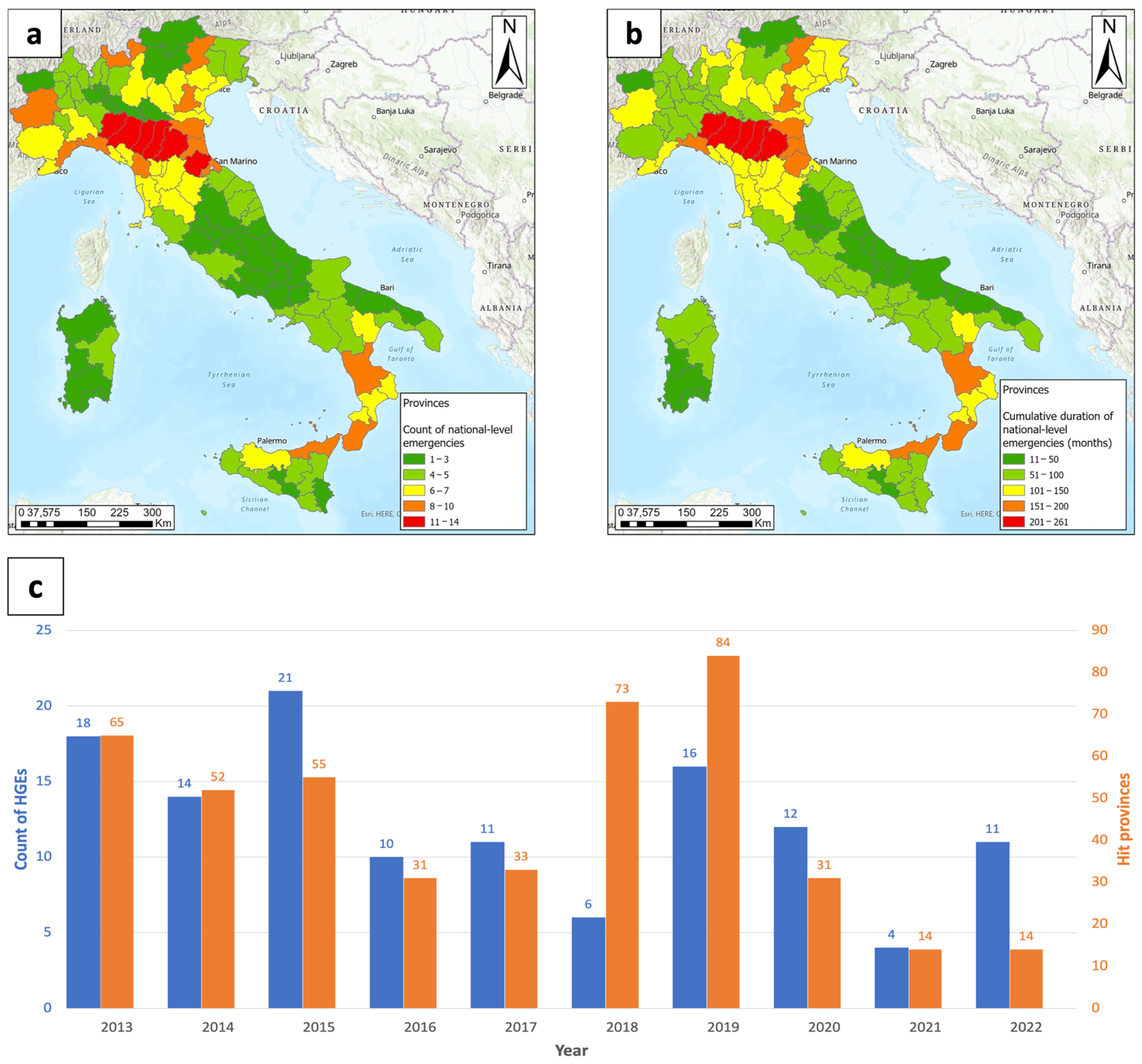
1. Summary
2. Data Description
2.1. Italian Emergencies 2013_2022 (Provinces Spreadsheet)
- Event_code: Emergency state identification code. It is an alphanumeric code that univocally identifies an HGE, and it is composed of the year of occurrence followed by an underscore and by a progressive ordinal number related to the chronology within the considered year. For instance, 2018_03 represents the third HGE that occurred in 2018.
- Province: Name of the province.
- Prov_code: Standardized code that univocally identifies the province of occurrence, as defined by ISTAT (Italian Institute for Statistics).
- Nuts_code: Identifier of the province of occurrence, standardized at the European level.
- ES y/n: Binary code (0;1) expressing inclusion within the emergency state (ES). 0 = The province is hit by the event but not included in the emergency state; 1 = The province is hit by the event and included in the emergency state.
- Civil Protection Ordinance: Number and date of each ordinance connected to the emergency state (e.g., an ordinance to issue the emergency state and possible ordinances to postpone its end). These are official codes reported in all administrative and legal acts.
- Ev1end: End date of the first period of occurrence of the critical event.
- Ev2start: Start date of the second critical event (if present).
- Ev2end: End date of the second critical event (if present).
- Ev3start: Start date of the third critical event (if present).
- Ev3end: End date of the third critical event (if present).
- Ev4start: Start date of the fourth critical event (if present).
- Ev4end: End date of the fourth critical event (if present).
- Detail: 1 = High detail (daily precision): the exact start/end days of the event are reported. 2 = Medium detail: the exact start/end days are reported, the event has a long duration (more than one week and less than one month), and the exact days may slightly vary from one place to another. 3 = Low detail: the months of occurrence are reported, and the exact days are unknown.
- The last block of information concerns bureaucratic details.
- ES_start: Start date of the emergency state.
- ES_end: End date of the emergency state. The end of the emergency is declared once the socioeconomic condition of the territory is deemed to have returned to the same level as before the event. Typically, for severe events, it takes some years.
- Funds_received: Amount of statal funds transferred to the Delegated Commissioner (DC), who is in charge of managing the emergency [€].
- Funds_req_prod: Funds requested by the DC to restore production activities, based on a preliminary recognition of needs [€].
- Funds_req_tot: Funds requested by the Delegated Commissioner, in total, based on a preliminary recognition of needs [€].
2.2. Italian Emergencies 2013_2022 (Municipalities Spreadsheet)
- Municipality: Name of the municipality
- Mun_code: ISTAT code for each municipality.
- LAU_code: Identifier of the municipality, standardized at the European level.
2.2.1. Provinces Shapefile
- Region: Name of the region
- Province: Name of the province
- Prov_code: Standardized code that univocally identifies the province of occurrence, as defined by ISTAT.
- Nuts_code: Identifier of the province of occurrence, standardized at the European level.
- N_ES: Number of times the province was included in an emergency state (ES)
- M_ES: Cumulative number of months of duration of the Ess.
2.2.2. Municipalities Shapefile
- Municipality: Name of the Municipality
- Mun_code: Standardized code that univocally identifies the municipality of occurrence, as defined by ISTAT
- LAU_code: Identifier of the municipality, standardized at the European level.
- N_ES: Number of times the municipality was included in an emergency state.
- M_ES: Cumulative number of months of duration of the ESs.
3. Methods
4. User Notes
Supplementary Materials
Author Contributions
Funding
Institutional Review Board Statement
Informed Consent Statement
Data Availability Statement
Acknowledgments
Conflicts of Interest
References
- Winsemius, H.C.; Aerts, J.C.J.H.; Van Beek, L.P.H.; Bierkens, M.F.P.; Bouwman, A.; Jongman, B.; Kwadijk, J.C.J.; Ligtvoet, W.; Lucas, P.L.; Van Vuuren, D.P.; et al. Global Drivers of Future River Flood Risk. Nat. Clim. Change 2016, 6, 381–385. [Google Scholar] [CrossRef]
- Arnell, N.W.; Gosling, S.N. The Impacts of Climate Change on River Flood Risk at the Global Scale. Clim. Change 2016, 134, 387–401. [Google Scholar] [CrossRef]
- Zhang, W.; Wu, C.; Tang, L.; Gu, X.; Wang, L. Efficient Time-Variant Reliability Analysis of Bazimen Landslide in the Three Gorges Reservoir Area Using XGBoost and LightGBM Algorithms. Gondwana Res. 2023, 123, 41–53. [Google Scholar] [CrossRef]
- Zeng, T.; Guo, Z.; Wang, L.; Jin, B.; Wu, F.; Guo, R. Tempo-Spatial Landslide Susceptibility Assessment from the Perspective of Human Engineering Activity. Remote Sens. 2023, 15, 4111. [Google Scholar] [CrossRef]
- Elahi, E.; Khalid, Z.; Zhang, Z. Understanding Farmers’ Intention and Willingness to Install Renewable Energy Technology: A Solution to Reduce the Environmental Emissions of Agriculture. Appl. Energy 2022, 309, 118459. [Google Scholar] [CrossRef]
- Abbas, A.; Waseem, M.; Ullah, W.; Zhao, C.; Zhu, J. Spatiotemporal Analysis of Meteorological and Hydrological Droughts and Their Propagations. Water 2021, 13, 2237. [Google Scholar] [CrossRef]
- Wijeratne, V.P.I.S.; Li, G.; Mehmood, M.S.; Abbas, A. Assessing the Impact of Long-Term ENSO, SST, and IOD Dynamics on Extreme Hydrological Events (EHEs) in the Kelani River Basin (KRB), Sri Lanka. Atmosphere 2023, 14, 79. [Google Scholar] [CrossRef]
- Liang, X.; Segoni, S.; Yin, K.; Du, J.; Chai, B.; Tofani, V.; Casagli, N. Characteristics of Landslides and Debris Flows Triggered by Extreme Rainfall in Daoshi Town during the 2019 Typhoon Lekima, Zhejiang Province, China. Landslides 2022, 19, 1735–1749. [Google Scholar] [CrossRef]
- Soeder, D.J. Fossil Fuels and Climate Change. In Fracking and the Environment; Springer: Berlin/Heidelberg, Germany, 2021; pp. 155–185. [Google Scholar] [CrossRef]
- Rajak, J. A Preliminary Review on Impact of Climate Change and Our Environment with Reference to Global Warming. Int. J. Environ. Sci. 2021, 10, 11–14. [Google Scholar]
- Ozturk, U.; Bozzolan, E.; Holcombe, E.A.; Shukla, R.; Pianosi, F.; Wagener, T. How Climate Change and Unplanned Urban Sprawl Bring More Landslides. Nature 2022, 608, 262–265. [Google Scholar] [CrossRef]
- Fiorini, L.; Zullo, F.; Marucci, A.; Romano, B. Land Take and Landscape Loss: Effect of Uncontrolled Urbanization in Southern Italy. J. Urban. Manag. 2019, 8, 42–56. [Google Scholar] [CrossRef]
- Feng, B.; Zhang, Y.; Bourke, R. Urbanization Impacts on Flood Risks Based on Urban Growth Data and Coupled Flood Models. Nat. Hazards 2021, 106, 613–627. [Google Scholar] [CrossRef]
- Jaedicke, C.; Van Den Eeckhaut, M.; Nadim, F.; Hervás, J.; Kalsnes, B.; Vangelsten, B.V.; Smith, J.T.; Tofani, V.; Ciurean, R.; Winter, M.G.; et al. Identification of Landslide Hazard and Risk “hotspots” in Europe. Bull. Eng. Geol. Environ. 2014, 73, 325–339. [Google Scholar] [CrossRef]
- Dilley, M.; Chen, R.S.; Deichmann, U.; Lerner-Lam, A.L.; Arnold, M. Natural Disaster Hotspots: A Global Risk Analysis; World Bank: Washington, DC, USA, 2005. [Google Scholar] [CrossRef]
- Luti, T.; Segoni, S.; Catani, F.; Munafò, M.; Casagli, N. Integration of Remotely Sensed Soil Sealing Data in Landslide Susceptibility Mapping. Remote Sens. 2020, 12, 1486. [Google Scholar] [CrossRef]
- Napoli, M.; Massetti, L.; Orlandini, S. Hydrological Response to Land Use and Climate Changes in a Rural Hilly Basin in Italy. Catena 2017, 157, 1–11. [Google Scholar] [CrossRef]
- Guzzetti, F.; Tonelli, G. Information System on Hydrological and Geomorphological Catastrophes in Italy (SICI): A Tool for Managing Landslide and Flood Hazards. Nat. Hazards Earth Syst. Sci. 2004, 4, 213–232. [Google Scholar] [CrossRef]
- Lastoria, B.; Simonetti, M.R.; Casaioli, M.; Mariani, S.; Monacelli, G. Socio-Economic Impacts of Major Floods in Italy from 1951 to 2003. Adv. Geosci. 2006, 7, 223–229. [Google Scholar] [CrossRef][Green Version]
- Salvati, P.; Petrucci, O.; Rossi, M.; Bianchi, C.; Pasqua, A.A.; Guzzetti, F. Gender, Age and Circumstances Analysis of Flood and Landslide Fatalities in Italy. Sci. Total Environ. 2018, 610–611, 867–879. [Google Scholar] [CrossRef]
- Petrucci, O.; Aceto, L.; Bianchi, C.; Bigot, V.; Brázdil, R.; Pereira, S.; Kahraman, A.; Kiliç, Ö.; Kotroni, V.; Llasat, M.C.; et al. Flood Fatalities in Europe, 1980–2018: Variability, Features, and Lessons to Learn. Water 2019, 11, 1682. [Google Scholar] [CrossRef]
- Battistini, A.; Rosi, A.; Segoni, S.; Lagomarsino, D.; Catani, F.; Casagli, N. Validation of Landslide Hazard Models Using a Semantic Engine on Online News. Appl. Geogr. 2017, 82, 59–65. [Google Scholar] [CrossRef]
- Calvello, M.; Pecoraro, G. FraneItalia: A Catalog of Recent Italian Landslides. Geoenviron. Disasters 2018, 5, 1–16. [Google Scholar] [CrossRef]
- Battistini, A.; Segoni, S.; Manzo, G.; Catani, F.; Casagli, N. Web Data Mining for Automatic Inventory of Geohazards at National Scale. Appl. Geogr. 2013, 43, 147–158. [Google Scholar] [CrossRef]
- Franceschini, R.; Rosi, A.; Catani, F.; Casagli, N. Exploring a Landslide Inventory Created by Automated Web Data Mining: The Case of Italy. Landslides 2022, 19, 841–853. [Google Scholar] [CrossRef]
- Trigila, A.; Iadanza, C.; Spizzichino, D. Quality Assessment of the Italian Landslide Inventory Using GIS Processing. Landslides 2010, 7, 455–470. [Google Scholar] [CrossRef]
- Segoni, S.; Piciullo, L.; Gariano, S.L. Preface: Landslide Early Warning Systems: Monitoring Systems, Rainfall Thresholds, Warning Models, Performance Evaluation and Risk Perception. Nat. Hazards Earth Syst. Sci. 2018, 18, 3179–3186. [Google Scholar] [CrossRef]
- Rosvold, E.L.; Buhaug, H. GDIS, a Global Dataset of Geocoded Disaster Locations. Sci. Data 2021, 8, 61. [Google Scholar] [CrossRef] [PubMed]
- Lindersson, S.; Brandimarte, L.; Mård, J.; Di Baldassarre, G. A Review of Freely Accessible Global Datasets for the Study of Floods, Droughts and Their Interactions with Human Societies. Wiley Interdiscip. Rev. Water 2020, 7, e1424. [Google Scholar] [CrossRef]
- Guha-Sapir, D.; Below, R.; Hoyois, P. EM-DAT: International Disaster Database; Centre for Research on the Epidemiology of Disasters (CRED): Brussels, Belgium, 2014. [Google Scholar]
- Caleca, F.; Tofani, V.; Segoni, S.; Raspini, F.; Franceschini, R.; Rosi, A. How Can Landslide Risk Maps Be Validated? Potential Solutions with Open-Source Databases. Front. Earth Sci. 2022, 10, 998885. [Google Scholar] [CrossRef]
- Molinari, D.; De Bruijn, K.M.; Castillo-Rodríguez, J.T.; Aronica, G.T.; Bouwer, L.M. Validation of Flood Risk Models: Current Practice and Possible Improvements. Int. J. Disaster Risk Reduct. 2019, 33, 441–448. [Google Scholar] [CrossRef]
- Dazzi, S.; Vacondio, R.; Mignosa, P. Flood Stage Forecasting Using Machine-Learning Methods: A Case Study on the Parma River (Italy). Water 2021, 13, 1612. [Google Scholar] [CrossRef]
- Zischg, A.P.; Mosimann, M.; Bernet, D.B.; Röthlisberger, V. Validation of 2D Flood Models with Insurance Claims. J. Hydrol. 2018, 557, 350–361. [Google Scholar] [CrossRef]
- Amadio, M.; Rita Scorzini, A.; Carisi, F.; Essenfelder, H.A.; Domeneghetti, A.; Mysiak, J.; Castellarin, A. Testing Empirical and Synthetic Flood Damage Models: The Case of Italy. Nat. Hazards Earth Syst. Sci. 2019, 19, 661–678. [Google Scholar] [CrossRef]
- Marin, G.; Modica, M. Socio-Economic Exposure to Natural Disasters. Environ. Impact Assess. Rev. 2017, 64, 57–66. [Google Scholar] [CrossRef]
- Rossi, M.; Guzzetti, F.; Salvati, P.; Donnini, M.; Napolitano, E.; Bianchi, C. A Predictive Model of Societal Landslide Risk in Italy. Earth Sci. Rev. 2019, 196, 102849. [Google Scholar] [CrossRef]
- Bignami, D.F.; Dragoni, A.; Menduni, G. Assessing and Improving Flood and Landslide Community Social Awareness and Engagement via a Web Platform: The Case of Italy. Int. J. Disaster Risk Sci. 2018, 9, 530–540. [Google Scholar] [CrossRef]
- Presidenza del Consiglio dei Ministri; Dipartimento per la Protezione Civile Emergenze per Il Rischio Meteo-Idro. Available online: https://www.protezionecivile.gov.it/it/dipartimento/amministrazione-trasparente/interventi-straordinari-e-di-emergenza/emergenze-il-rischio-meteo-idro/ (accessed on 29 June 2023).
- Italian Tax Agency OMI, Italian Real Estate Market. Available online: https://www.agenziaentrate.gov.it/portale/web/guest/schede/fabbricatiterreni/omi/forniture-dati-omi (accessed on 29 June 2023).
- ISTAT (Istituto Nazionale di Statistica) StatBase. Available online: https://www.istat.it/en/analysis-and-products/databases/statbase (accessed on 29 June 2023).
- Iadanza, C.; Trigila, A.; Starace, P.; Dragoni, A.; Biondo, T.; Roccisano, M. IdroGEO: A Collaborative Web Mapping Application Based on REST API Services and Open Data on Landslides and Floods in Italy. ISPRS Int. J. Geoinf. 2021, 10, 89. [Google Scholar] [CrossRef]
- ISPRA (Istituto Superiore per la Protezione e la Ricerca Ambientale) IdroGEO. Available online: https://idrogeo.isprambiente.it/app/ (accessed on 29 June 2023).
- Langella, G.; Basile, A.; Giannecchini, S.; Moccia, F.D.; Mileti, F.A.; Munafó, M.; Pinto, F.; Terribile, F. Soil Monitor: An Internet Platform to Challenge Soil Sealing in Italy. Land. Degrad. Dev. 2020, 31, 2883–2900. [Google Scholar] [CrossRef]
- ISPRA (Istituto Superiore per la Protezione e la Ricerca Ambientale) Soil Sealing Monitoring Program. Available online: https://groupware.sinanet.isprambiente.it/uso-copertura-e-consumo-di-suolo/library (accessed on 4 July 2023).
- Global Human Settlement Layer; Pesaresi, M.; Politis, P. GHS-BUILT-S R2023A—GHS Built-up Surface Grid, Derived from Sentinel2 Composite and Landsat, Multitemporal (1975–2030). Available online: https://ghsl.jrc.ec.europa.eu/ (accessed on 29 June 2023).
- European Union; Copernicus Land Monitoring Service; European Environment Agency Corine Land Cover. Available online: https://land.copernicus.eu/pan-european/corine-land-cover (accessed on 29 June 2023).
- SOSE (Italian Ministry of Economy and Finance, and C.I.B). Open Civitas Project. Available online: https://www.opencivitas.it/en (accessed on 29 June 2023).
- Bank of Italy Bank of Italy Statistical Database. Available online: https://infostat.bancaditalia.it/inquiry/home?spyglass/taxo:CUBESET=&ITEMSELEZ=&OPEN=false/&ep:LC=EN&COMM=BANKITALIA&ENV=LIVE&CTX=DIFF&IDX=1&/view:CUBEIDS=&graphMode= (accessed on 29 June 2023).
- Italian Ministry of Economy and Finance MEF Open Data. Available online: https://www1.finanze.gov.it/finanze/analisi_stat/public/index.php?search_class%5B0%5D=cCOMUNE&opendata=yes (accessed on 29 June 2023).
- Eurostat Data Browser. Available online: https://ec.europa.eu/eurostat/databrowser/view/bd_size_r3/default/table?lang=en (accessed on 29 June 2023).


| Dataset | Issuer | Topic | Reference | Updating Frequency | Spatial Aggregation | Key for Linkage |
|---|---|---|---|---|---|---|
| OMI | Italian Tax Agency | Real estate market | [40] | 6 months | LAU | ISTAT code |
| StatBase | ISTAT | Demography, census, society, social expenditure, economy, territory | [41] | Yearly | LAU | ISTAT code |
| Idrogeo | ISPRA | Hazard and risk indicators | [42,43] | semistatic | LAU | ISTAT code |
| Soil sealing monitoring program | ISPRA | Soil sealing, land cover, urban areas | [44,45] | yearly | LAU | ISTAT code/GIS spatial join |
| Global Human Settlement Layer | Copernicus | Built up soil (residential and other uses); population; degree of urbanization | [46] | 5 years | LAU | GIS spatial join |
| Corine Land Cover | European Environmental Agency/Copernicus | land use/land cover classification | [47] | 6 years | LAU | GIS spatial join/LAU code |
| Open Civitas project | SOSE | Quality and cost of public services | [48] | yearly | LAU | ISTAT code |
| Bank of Italy statistical database | Bank of Italy | Loans, public finance, bank fundings | [49] | yearly | LAU | ISTAT code |
| MEF Open Data | Ministry of Economy and Finance | Taxable income, taxpayer | [50] | yearly | LAU | ISTAT code |
| Data Browser | Eurostat | Employees, business demography | [51] | yearly | NUTS | NUTS code |
| MEF Open Data | Ministry of Economy and Finance | Taxable income, taxpayer | [50] | yearly | LAU | ISTAT code |
| Data Browser | Eurostat | Employees, business demography | [51] | yearly | NUTS | NUTS code |
Disclaimer/Publisher’s Note: The statements, opinions and data contained in all publications are solely those of the individual author(s) and contributor(s) and not of MDPI and/or the editor(s). MDPI and/or the editor(s) disclaim responsibility for any injury to people or property resulting from any ideas, methods, instructions or products referred to in the content. |
© 2023 by the authors. Licensee MDPI, Basel, Switzerland. This article is an open access article distributed under the terms and conditions of the Creative Commons Attribution (CC BY) license (https://creativecommons.org/licenses/by/4.0/).
Share and Cite
Gatto, A.; Clò, S.; Martellozzo, F.; Segoni, S. Tracking a Decade of Hydrogeological Emergencies in Italian Municipalities. Data 2023, 8, 151. https://doi.org/10.3390/data8100151
Gatto A, Clò S, Martellozzo F, Segoni S. Tracking a Decade of Hydrogeological Emergencies in Italian Municipalities. Data. 2023; 8(10):151. https://doi.org/10.3390/data8100151
Chicago/Turabian StyleGatto, Alessio, Stefano Clò, Federico Martellozzo, and Samuele Segoni. 2023. "Tracking a Decade of Hydrogeological Emergencies in Italian Municipalities" Data 8, no. 10: 151. https://doi.org/10.3390/data8100151
APA StyleGatto, A., Clò, S., Martellozzo, F., & Segoni, S. (2023). Tracking a Decade of Hydrogeological Emergencies in Italian Municipalities. Data, 8(10), 151. https://doi.org/10.3390/data8100151