Landslide Inventory (2001–2017) of Chittagong Hilly Areas, Bangladesh


Abstract
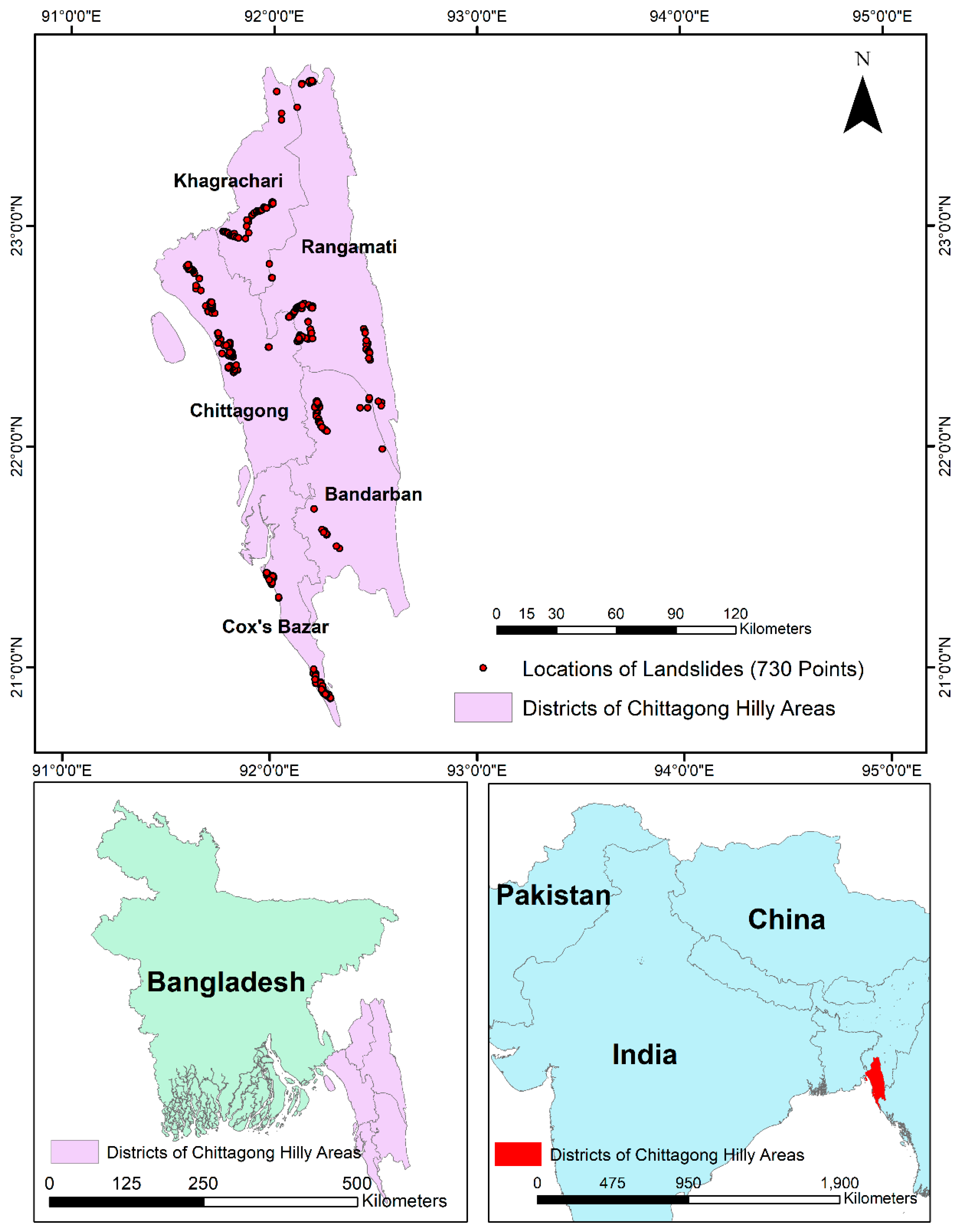
1. Introduction
2. Data Description
Design of the Dataset
3. Methodology
Accuracy Assessment
4. Inventory Statistics
Supplementary Materials
Supplementary File 1Author Contributions
Funding
Conflicts of Interest
References
- Guzzetti, F.; Mondini, A.C.; Cardinali, M.; Fiourucci, F.; Santangelo, M.; Chang, K.T. Landslide inventory maps: New tools for an old problem. Earth Sci. Rev. 2012, 112, 42–66. [Google Scholar] [CrossRef]
- Alkevi, T.; Ercanoglu, M. Assessment of ASTER satellite images in landslide inventory mapping: Yenice Gokcebey (Western Black Sea region: Turkey). Bull. Eng. Geol. 2011, 70, 607–617. [Google Scholar] [CrossRef]
- Yilmaz, I. Landslide susceptibility mapping using frequency ratio, logistic regression, artificial neural networks, and their comparison a case study for Kat landslides. Comput. Geosci. 2009, 35, 1125–1138. [Google Scholar] [CrossRef]
- Chen, W.C.; Chen, H.; We, L.W.; Lin, G.W.; Lida, T.; Yamada, R. Evaluating the susceptibility of landslide landforms in Japan using slope stability analysis: A case study of the 2016 Kumamoto earthquake. Landslides 2017, 14, 1793–1801. [Google Scholar] [CrossRef]
- Rabby, Y.W.; Li, Y. An Integrated Approach to map landslides in Chittagong Hilly Areas, Bangladesh, using Google Earth and field mapping. Landslides 2019, 16, 633–645. [Google Scholar] [CrossRef]
- Galli, M.; Ardizzone, F.; Cardinali, M.; Guzzettie, F.; Reichenbach, P. Comparing landslide inventory maps. Geomorphology 2008, 94, 268–289. [Google Scholar] [CrossRef]
- Islam, M.A.; Islam, M.S.; Islam, T. Landslides in Chittagong hill tracts and possible measures. In Proceedings of the International Conference on Disaster Risk Mitigation, Dhaka, Bangladesh, 23–24 September 2017. [Google Scholar]
- Ahmed, B. Landslide susceptibility mapping using multi-criteria evaluation techniques in Chittagong Metropolitan Area, Bangladesh. Landslides 2015, 12, 1077–1095. [Google Scholar] [CrossRef]
- Ahmed, B.; Dewan, A. Application of Bivariate and Multivariate Statistical Techniques in Landslide Susceptibility Modeling in Chittagong City Corporation, Bangladesh. Remote Sens. 2017, 9, 304. [Google Scholar] [CrossRef]
- Ahmed, B. Landslide Susceptibility Modelling Applying User-Defined Weighting and Data-Driven Statistical Techniques in Cox’s Bazar Municipality, Bangladesh. Nat. Hazar. 2015, 79, 1707–1737. [Google Scholar] [CrossRef]
- Sifa, S.F.; Mahmud, T.; Tarin, M.A.; Haque, D.M.E. Event-based landslide susceptibility mapping using weights of evidence (WoE0 and modified frequency ratio (MFR) model: A case study of Rangamati district in Bangladesh. Geol. Ecol. Landsc. 2019, 1–14. [Google Scholar] [CrossRef]
- CDMP II Landslide Inventory and Landuse Mapping, DEM Preparation, Precipitation Threshold Value and Establishment of Early Warning Device; Comprehensive Disaster Management Programme-II (CDMP-II); Ministry of Food and Disaster Management (MoFDM) Disaster Management and Relief Division (DMRD) Government of the People’s Republic of Bangladesh: Dhaka, Bangladesh, 2012.
- Cruden, D.M.; Varnes, D.J. Landslide types and processes. In Landslides, Investigation and Mitigation; Special Report 247; Turner, A.K., Schuster, R.L., Eds.; Transportation Research Board: Washington, DC, USA, 1996; pp. 36–75. ISBN 030906208X. [Google Scholar]
- Crawford, M.M. Kentucky Geological Survey Landslide Inventory: From Design to Application. Available online: https://pdfs.semanticscholar.org/c986/834ae8767c54a16745b0c8538529afaba4f8.pdf (accessed on 15 September 2019).
- Dikau, R. The Recognition of Landslides. In Floods and Landslides: Integrated Risk Assessment; Environmental Science; Casale, R., Margottini, C., Eds.; Springer, Science and Business Media: Berlin/Heidelberg, Germany, 1999. [Google Scholar]
- Rahman, M.S.; Ahmed, B.; Huq, F.F.; Rahman, S.; Al-Hussain, T.M. Landslide inventory in an urban setting in the context of Chittagong Metropolitan Area, Bangladesh. In Proceedings of the 3rd International Conference in Civil Engineering, CUET, Chittagong, Bangladesh, 21–23 December 2016; pp. 170–178. Available online: https://www.researchgate.net/publication/308171472_Landslide_Inventory_in_an_Urban_Setting_in_the_Context_of_Chittagong_Metropolitan_Area_Bangladesh (accessed on 9 December 2019).
- Samodra, G.; Chen, G.; Sartohadi, J.; Kasama, K. Generating landslide inventory by participatory mapping: An example in Purwosari Area, Yogyakarta, Java. Geomorphology 2018, 306, 306–313. [Google Scholar] [CrossRef]


| Type of Attribute | Data Type | Full Explanation | Comment |
|---|---|---|---|
| ID | Number | Identification Number | |
| District | Text | The district is the second administrative boundary of Bangladesh. Five districts: Bandarban, Chittagong, Cox’s Bazar, Khagrachari, and Rangamati. | |
| Location | Text | Detail address of the landslide location. | |
| Fail_Type | Text | Type of failure | Five types (slide, flow, fall, topple and complex) of landslides have been identified based on [13]. The types of 77 landslides were not identified and kept as unrecognized. |
| Date | Text | Generally, the exact date has been recorded. For Google Earth mapping, the date of the image was recorded. | |
| State | Text | Sate of the landslides | Six types of states: active, dormant, inactive, reactivated, stabilized, and suspended. The state of 231 landslides was not determined. |
| Distri_ | Text | Distribution of landslides | Five types of distribution: advancing, diminishing, moving, retrogressive, and widening. The distribution of 286 landslides was not determined. |
| Water_Cont | Text | Water content in the scarp | Two types of water content: wet and dry. The water content of 350 landslides was not determined. |
| Material | Text | The material of the mass moved | Materials include soil, debris, weathered rock and soil, rock. and soil, and a mixture of these materials. For 272 landslides, the material was not determined. |
| Death_ | Text | Number of deaths | |
| Settlemet_ | Text | Number of settlement damaged | |
| Dam_Int1 | Text | Settlement damage intensity | Qualitative judgement (high, medium, and low) of the field investigators. The damage intensity of 271 landslides was not determined. |
| Damae_Int2 | Text | Road damage intensity | Qualitative judgement (high, medium, and low) of the field investigators. The damage intensity of 271 landslides was not determined. |
| Economic | Text | Economic loss caused by the landslides | Qualitative judgement (high, medium, and low) of the field investigators. The damage intensity of 271 landslides was not determined. |
| Area | Number | Area of landslides | Number of Decimal Places = 0. |
| Triggers_ | Text | Triggers of landslides |
| Area of Landslides (m2) | Number of Landslides | Percentage of Landslides |
|---|---|---|
| 0–50 | 185 | 28 |
| 50–100 | 109 | 17 |
| 100–200 | 68 | 10 |
| 200–500 | 102 | 16 |
| 500–1000 | 74 | 11 |
| 1000–10,000 | 91 | 14 |
| 10,000–1,000,000 | 23 | 4 |
© 2019 by the authors. Licensee MDPI, Basel, Switzerland. This article is an open access article distributed under the terms and conditions of the Creative Commons Attribution (CC BY) license (http://creativecommons.org/licenses/by/4.0/).
Share and Cite
Rabby, Y.W.; Li, Y. Landslide Inventory (2001–2017) of Chittagong Hilly Areas, Bangladesh. Data 2020, 5, 4. https://doi.org/10.3390/data5010004
Rabby YW, Li Y. Landslide Inventory (2001–2017) of Chittagong Hilly Areas, Bangladesh. Data. 2020; 5(1):4. https://doi.org/10.3390/data5010004
Chicago/Turabian StyleRabby, Yasin Wahid, and Yingkui Li. 2020. "Landslide Inventory (2001–2017) of Chittagong Hilly Areas, Bangladesh" Data 5, no. 1: 4. https://doi.org/10.3390/data5010004
APA StyleRabby, Y. W., & Li, Y. (2020). Landslide Inventory (2001–2017) of Chittagong Hilly Areas, Bangladesh. Data, 5(1), 4. https://doi.org/10.3390/data5010004