Data Descriptor

Removal of Positive Elevation Bias of Digital Elevation Models for Sea-Level Rise Planning

1
Department of Biodiversity, Earth & Environmental Sciences and the Academy of Natural Sciences, Drexel University, Philadelphia, PA 19103, USA
2
Partnership for the Delaware Estuary, Wilmington, DE 19801, USA
3
Academy of Natural Sciences, Drexel University, Philadelphia, PA 19103, USA
4
The Barnegat Bay Partnership, Toms River, NJ 08754, USA
5
University of Maryland Center for Environmental Science, MD 20688, USA
*
Author to whom correspondence should be addressed.
Submission received: 7 March 2019 / Revised: 21 March 2019 / Accepted: 21 March 2019 / Published: 26 March 2019

Abstract

:
Digital elevation models (DEMs) based on LiDAR surveys provide critical information for predicting the vulnerability of coastal areas to sea-level rises. Due to the poor penetration of LiDAR pulses in marsh vegetation, bare-earth DEMs for coastal wetlands are often subject to positive elevation bias, and thus underestimate vulnerability. This data publication includes comprehensive elevation surveys from seven coastal wetlands in coastal New Jersey, and an evaluation of the accuracy and positive elevation bias of each publically available DEM. Resampling the DEMs at a coarser resolution, replacing cell values using the minimum value in a wider search window (4 m), removed this positive elevation bias with no loss of accuracy.
Dataset: The following are available online at https://www.mdpi.com/2306-5729/4/1/46/s1.
Dataset License: CC0

1. Summary

The rate of global sea-level rise (SLR) has increased abruptly, relative to stable Late Holocene rates of 0.5–1.0 mm yr−1 that have prevailed over the last 2000 years [1,2], to 1.7 ± 0.3 mm∙yr−1 during the 20th century [3] and 3.1 ± 0.3 mm yr−1 since 1993 [4]. These rates of SLR are associated with trends in increasing temperature [5,6], and studies have generally concluded that statistically significant SLR acceleration is occurring [4]. Although there is significant variability by region in projected SLR rates, global rates by 2100 predicted by the IPCC AR5 report ranged from 28–61 to 52–98 cm, depending on emission scenarios. SLR will impact millions of coastal residents over the coming decades [7] and there is a strong need for accurate elevation models to characterize vulnerability to SLR for both the built environment, as well as coastal habitats such as dunes, beaches, and wetlands, which can act as natural defenses against SLR.
Coastal wetlands can protect coastal communities from event-based flooding, which is amplified by SLR [8]. However, they are themselves quite vulnerable to climate change, as their sustainability depends on the interplay between organic soil formation and sediment deposition relative to SLR rates [9]. If marshes can build up faster than the sea rises, they will be sustainable. If SLR exceeds accumulation rates, marshes will drown, and in this context, millimeters matter [9]. Although digital elevation models derived from light detection and ranging (LiDAR) surveys can be as accurate as typical GPS ground surveys (± 5 cm), the presence of thick vegetation in coastal wetlands obstructs the ground surface, leading to positive elevation biases that can result in underestimations of climate change vulnerability [10].
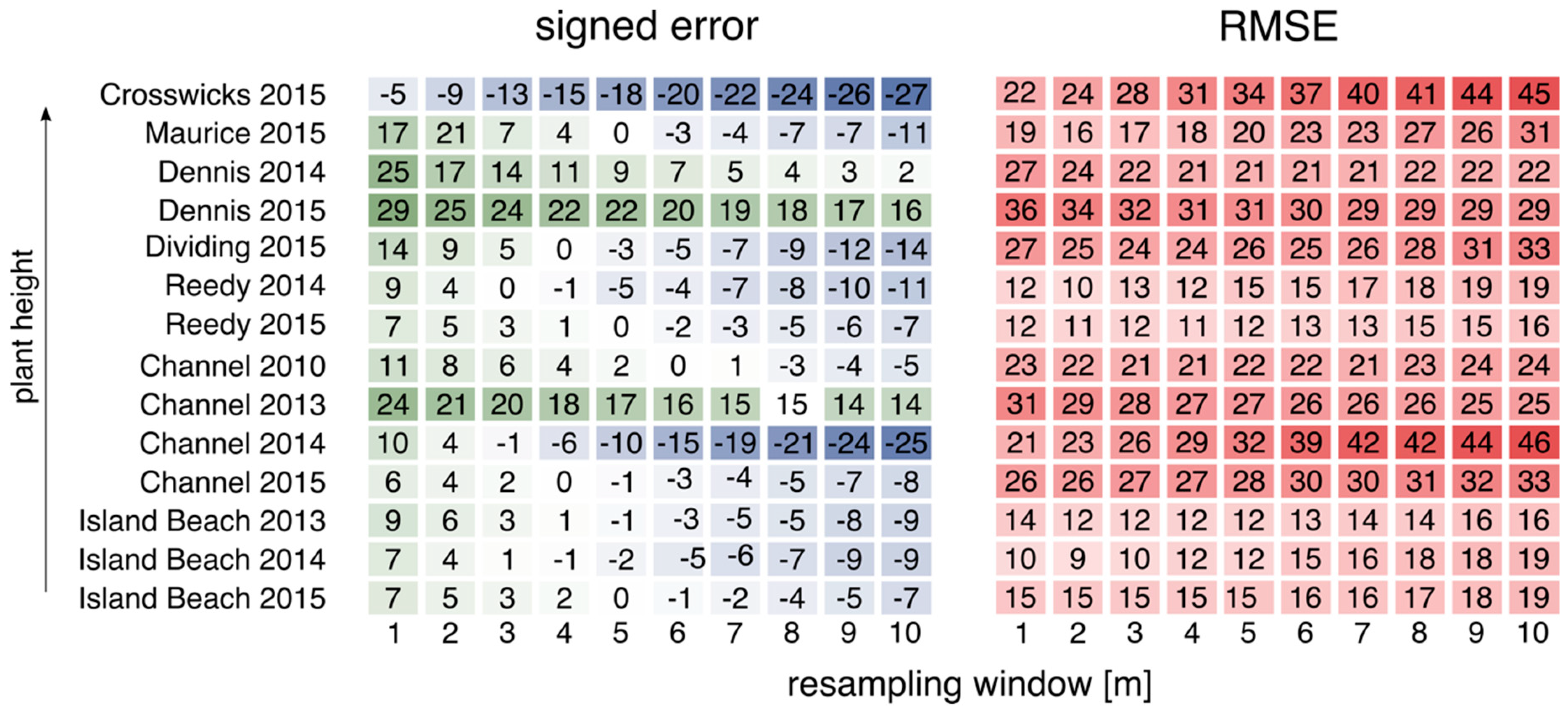
This dataset includes elevation data surveys (~3200 points) from seven New Jersey coastal wetlands, and was collected to ascertain the level of positive elevation bias found in digital elevation models (DEMs). We found that positive elevation biases (measured as signed error) ranged up to 0.3 m, which could significantly affect assessments of wetland vulnerability to SLR (Table 1). Post-processing DEMs using a minimum bin method largely removed positive elevation biases with minimal losses in accuracy (Figure 1). We found that resampling the DEM at 4 m resolution using the minimum bin method resulted in no loss of accuracy as measured by root mean square error (RMSE), but reduced the signed error from an average of 12 to 1.5 cm. Resampling at 5 m resolution increased the RMSE from 21 to 23 cm, and shifted the signed error to a negative elevation bias of −1.0 cm.
However, several of the DEMs we worked with did not conform to this trend and maintained a positive elevation bias even after post-processing (Figure 2), such as the 2013 DEM covering the research site at Channel Creek and the 2015 DEM covering Dennis Creek. In such cases, it may be more beneficial to use masks, potentially based on plant cover class, to improve DEM accuracy. This method has been used widely in coastal wetlands outside the Northeastern U.S., where the plant cover is found throughout the year (e.g., [11]). In the Northeast, by collecting LiDAR data in spring leaf-off conditions when the vegetation cover is sparse, the need for masks has largely been avoided.
By publishing this dataset, we intend for it to be used to guide DEM post-processing and to develop new DEM post-processing methods relevant to predicting impacts of sea-level rise in vegetated coastal areas. Future work using this data will include validating and applying SLR models for predicting coastal wetland vulnerability to climate change.

2. Data Description

2.1. Elevation Survey Points

Shapefiles of surveyed elevation points are provided for each individual study site (Table 2). These shapefiles consist of an elevation field, where the elevations are given in meters relative to the NAVD88 datum, GEOID12A. Elevation surveys were conducted between 2014 and 2018. A data inventory is provided (Supplementary Material, File 1).

2.2. Digital Elevation Model Metadata

Metadata is provided for the publically available DEMs analyzed as part of this study (Supplementary Material, File 3), following the Content Standard for Digital Geospatial Metadata: Extensions for Remote Sensing Metadata, FGDC-STD-012-2002. For each site, all publically available DEMs were analyzed, which ranged from one to four DEMs per study site (Table 3). For all DEMs, the initial resolution was 1 m, although DEMs were resampled and analyzed at a coarser resolution. A data inventory is provided (Supplementary Material). The 2010 DEM was adjusted from the GEOID09 to GEOID12A. The 2015 United State Geological Survey (USGS) topobathy DEM covers all of New Jersey and Delaware coastal areas, and consists of the best available multi-source topographic and bathymetric elevation data, integrating over 89 different data sources, including topographic and bathymetric LiDAR point clouds, hydrographic surveys, side-scan sonar surveys, and multi-beam surveys from various federal, state, and local agencies.

3. Methods

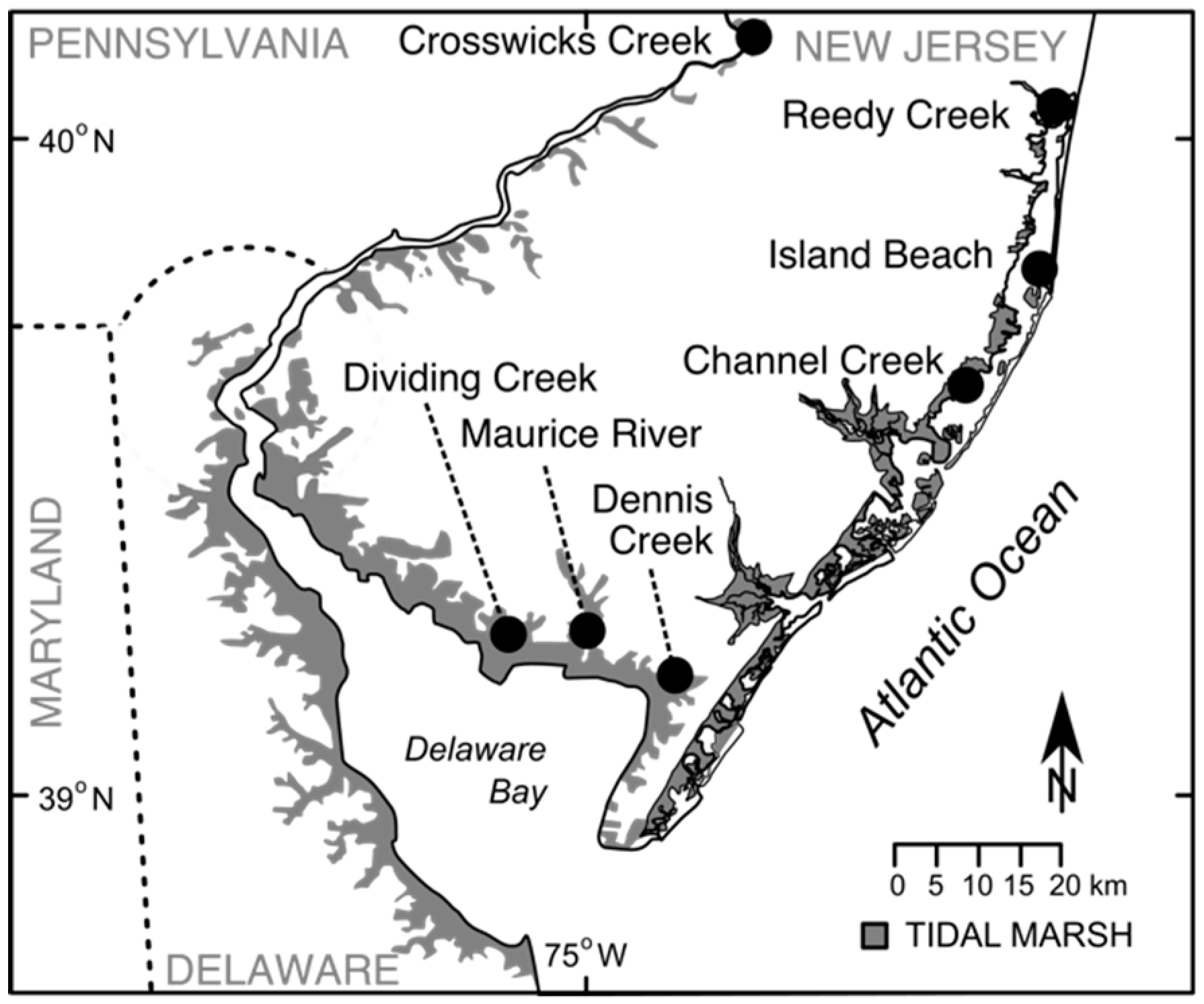
Elevation surveys were conducted in seven separate New Jersey (USA) coastal wetlands at long-term monitoring locations (https://www.macwa.org), using real-time kinematic GPS receivers (a Leica Viva GS14 GNSS Receiver and Viva CS15 field controller, or a Trimble R6 GNSS receiver and TSC2 data controller) to assess the vertical accuracy of bare-earth DEMs based on LiDAR surveys. Data collection followed National Geodetic Survey guidelines for the RT3 accuracy class (0.04–0.06m horizontal precision; 0.04–0.08 vertical precision): Baselines < 20 km and collection at 1 s intervals for 15 s, with a steady fixed height rover pole without use of a bipod [12]. Study sites were located in Barnegat Bay and Delaware Bay, New Jersey, USA (Table 2; Figure 3). Mean vegetation height and salinity were found to vary quite widely across study sites [13], with strong co-variance between salinity and the height of marsh vegetation, with lower salinity wetlands supporting taller marsh vegetation (r2 = 0.89, p = 0.001). Elevation surveys were conducted between 2014 and 2018. Surveyed points were downloaded from data controllers, and converted to point shapefiles (Supplementary Materials, File 2).
All publically available DEMs available for research sites were obtained (Table 3). To assess differences in elevation between the two datasets, points were intersected with as-delivered DEMs, as well as DEMs post-processed using the minimum bin method [14]. The minimum bin technique selects the lowest point in a cell to represent the grid or raster value, increasing the search window from two to ten meters. DEMs were then resampled at coarser resolutions (2–10 m) using the aggregate function, replacing elevation values with the minimum value of the wider search window. Elevation differences between datasets were again measured using point-DEM intersections. Geospatial analyses were conducted in ArcGIS ver. 10.5.

Supplementary Materials

File 1. Data Inventory. File 2. Coastal wetland elevation survey: Shapefile of elevation points; File 3. DEM metadata.

Author Contributions

Conceptualization, writing, formal analysis, and funding acquisition, E.B.W.; data curation, L.H. and K.R.; methodology, L.H., K.R., and E.R.

Funding

This work was supported by the New Jersey Sea Grant Consortium (NJSGC) with funds from the National Oceanic and Atmospheric Administration (NOAA) Office of Sea Grant, U.S. Department of Commerce, under NOAA grant number #NA14OAR4170085, and the U.S. EPA Region 2 Wetlands Program Development Grant CD97207600. The statements, findings, conclusions, and recommendations are those of the authors and do not necessarily reflect the views of the NJSGC or the U.S. Department of Commerce [NJ-19-942].

Acknowledgments

We thank the State of New Jersey and the U.S. Fish and Wildlife Service for access to field sites, and Metthea Yepson, New Jersey Department of Environmental Protection, for assistance in the field.

Conflicts of Interest

The authors declare no conflict of interest. The funders had no role in the design of the study; in the collection, analyses, or interpretation of data; in the writing of the manuscript; or in the decision to publish the results.

References

  1. Engelhart, S.E.; Horton, B.P.; Douglas, B.C.; Peltier, W.R.; Tornqvist, T.E. Spatial variability of late Holocene and 20th century sea-level rise along the Atlantic coast of the United States. Geology 2009, 37, 1115–1118. [Google Scholar] [CrossRef]
  2. Church, J.A.; White, N.J. Sea-level rise from the late 19th to the early 21st century. Surv. Geophys. 2011, 32, 585–602. [Google Scholar] [CrossRef]
  3. Church, J.A.; White, N.J. A 20th century acceleration in global sea-level rise. Geophys. Res. Lett. 2006, 33. [Google Scholar] [CrossRef] [Green Version]
  4. Cazenave, A.; Palanisamy, H.; Ablain, M. Contemporary sea level changes from satellite altimetry: What have we learned? What are the new challenges? Adv. Space Res. 2018, 62, 1639–1653. [Google Scholar] [CrossRef]
  5. Rahmstorf, S. A semi-empirical approach to projecting future sea-level rise. Science 2007, 315, 368–370. [Google Scholar] [CrossRef] [PubMed]
  6. Kemp, A.C.; Horton, B.; Donnelly, J.P.; Mann, M.E.; Vermeer, M.; Rahmstorf, S. Climate related sea-level variations over the past two millennia. Proc. Natl. Acad. Sci. USA 2011, 108, 11017–11022. [Google Scholar] [CrossRef] [Green Version]
  7. Hardy, R.D.; Hauer, M.E. Social vulnerability projections improve sea-level rise risk assessments. Appl. Geogr. 2018, 91, 10–20. [Google Scholar] [CrossRef] [Green Version]
  8. Narayan, S.; Beck, M.W.; Wilson, P.; Thomas, C.J.; Guerrero, A.; Shepard, C.C.; Reguero, B.G.; Franco, G.; Ingram, J.C.; Trespalacios, D. The value of coastal wetlands for flood damage reduction in the northeastern USA. Sci. Rep.-UK 2017, 7, 9463. [Google Scholar] [CrossRef]
  9. Blum, L.K.; Davey, E. Below the salt marsh surface: Visualization of plant roots by computer-aided tomography. Oceanography 2013, 26, 85–87. [Google Scholar] [CrossRef]
  10. Schmid, K.A.; Hadley, B.C.; Wijekoon, N. Vertical accuracy and use of topographic LIDAR data in coastal marshes. J. Coast. Res. 2011, 27, 116–132. [Google Scholar] [CrossRef]
  11. Hladik, C.; Alber, M. Accuracy assessment and correction of a LIDAR-derived salt marsh digital elevation model. Remote Sens. Environ. 2012, 121, 224–235. [Google Scholar] [CrossRef]
  12. Henning, W. User Guidelines for Single Base Real Time GNSS Positioning; National Geodetic Survey: Silver Spring, MD, USA, 2011; 138p. Available online: https://www.ngs.noaa.gov/PUBS_LIB/NGSRealTimeUserGuidelines.v2.1.pdf (accessed on 25 March 2019).
  13. Elsey-Quirk, T.; Watson, E.B.; Raper, K. Site-Specific Intensive Monitoring of Dividing Creek and Maurice River 2011–2014. Report Submitted to the Barnegat Bay Partnership and the Partnership for the Delaware Estuary. 2015. Available online: http://www.macwa.org/assets/img/com/DV_MR_2015.pdf (accessed on 25 March 2019).
  14. NOAA Coastal Services Center. LiDAR Data Collected in Marshes: Its Error and Application for Sea Level Rise Modeling. 2010. Available online: https://coast.noaa.gov/data/digitalcoast/pdf/lidar-marshes-slamm.pdf (accessed on 25 March 2019).
Figure 1. Comparison of RMSE and signed error for DEMs resampled using the minimum bin method.
Data 04 00046 g001
Figure 2. Comparison of RMSE and signed error for resampled DEMs (in cm).
Data 04 00046 g002
Figure 3. Location of elevation surveys and LiDAR comparisons.
Data 04 00046 g003
Table 1. Vertical elevation differences for the as-received LiDAR vs. topographic surveys.
Site NameDEM 1No. of PointsRMSE (cm)Signed Error (cm)25th Quartile (cm)75th Quartile (cm)
Crosswicks Creek2015 USGS57222.1−4.59−14.4−1.3
Dividing Creek2015 USGS87527.313.92.6219.6
Maurice River2015 USGS16219.416.811.022.7
Dennis Creek2014 NOAA22327.024.817.430.3
Dennis Creek2015 USGS22335.728.616.735.8
Reedy Creek2014 NOAA32911.78.793.7513.2
Reedy Creek2015 USGS32912.57.482.0310.1
Island Beach2013 USACE29413.99.351.5514.7
Island Beach2014 NOAA2949.877.402.9110.6
Island Beach2015 USGS29414.97.181.628.33
Channel Creek2010 ARRA69722.711.41.3810.9
Channel Creek2013 USACE69731.224.012.326.3
Channel Creek2014 NOAA69720.910.44.3414.9
Channel Creek2015 USGS69725.85.90-1.367.60
1 See Table 3 and metadata for full explanation of digital elevation models (DEMs).
Table 2. Surveyed locations in New Jersey coastal wetlands (Supplementary Material, File 2).
Site NameLocationSalinityVegetation Height (m)
Crosswicks Creek40°9.76′ N, 74°42.51′ W0.10‰1.2 m
Dividing Creek39°14.14′ N, 75°6.76′ W16.7‰0.32 m
Maurice River39°15.95′ N, 74°59.72′ W11.2‰0.56 m
Dennis Creek39°10.58′ N, 74°51.74′ W15.9‰0.34 m
Reedy Creek40°1.74′ N, 74°5.07′ W20.2‰0.29 m
Island Beach39°47.96′ N, 74°6.10′ W26.8‰0.17 m
Channel Creek39°37.43′ N, 74°16.20′ W25.6‰0.23 m
Table 3. Topobathy DEMs analyzed by this study.
Site NameDigital Elevation ModelResolutionDateSensor
Crosswicks2015 USGS CoNED1 mmultiple yearsmultiple sensors
Dividing2015 USGS CoNED1 mmultiple yearsmultiple sensors
Maurice2015 USGS CoNED1 mmultiple yearsmultiple sensors
Dennis2014 NOAA Post-Sandy1 mNov 2013–June 2014Riegl VQ-820G
Dennis2015 USGS CoNED1 mmultiple yearsmultiple sensors
Reedy2014 NOAA Post-Sandy1 mNov 2013–June 2014Riegl VQ-820G
Reedy2015 USGS CoNED1 mmultiple yearsmultiple sensors
Island Beach2013 USACE NCMP1 mSept 2013–Oct 2013CZMIL (USACE)
Island Beach2014 NOAA Post-Sandy1 mNov 2013–June 2014Riegl VQ-820G
Island Beach2015 USGS CoNED1 mmultiple yearsmultiple sensors
Channel2010 ARRA1 mApr 2010Leica ALS60 MPiA
Channel2013 USACE NCMP1 mJune 2013CZMIL (USACE)
Channel2014 NOAA Post-Sandy1 mNov 2013–June 2014Riegl VQ-820G
Channel2015 USGS CoNED1 mmultiple yearsmultiple sensors