
Hydro-Stratigraphic Conditions and Human Activity Leading to Development of a Sinkhole Cluster in a Mediterranean Water Ecosystem

 ,
,  and
and 
Abstract
:1. Introduction
2. Materials and Methods
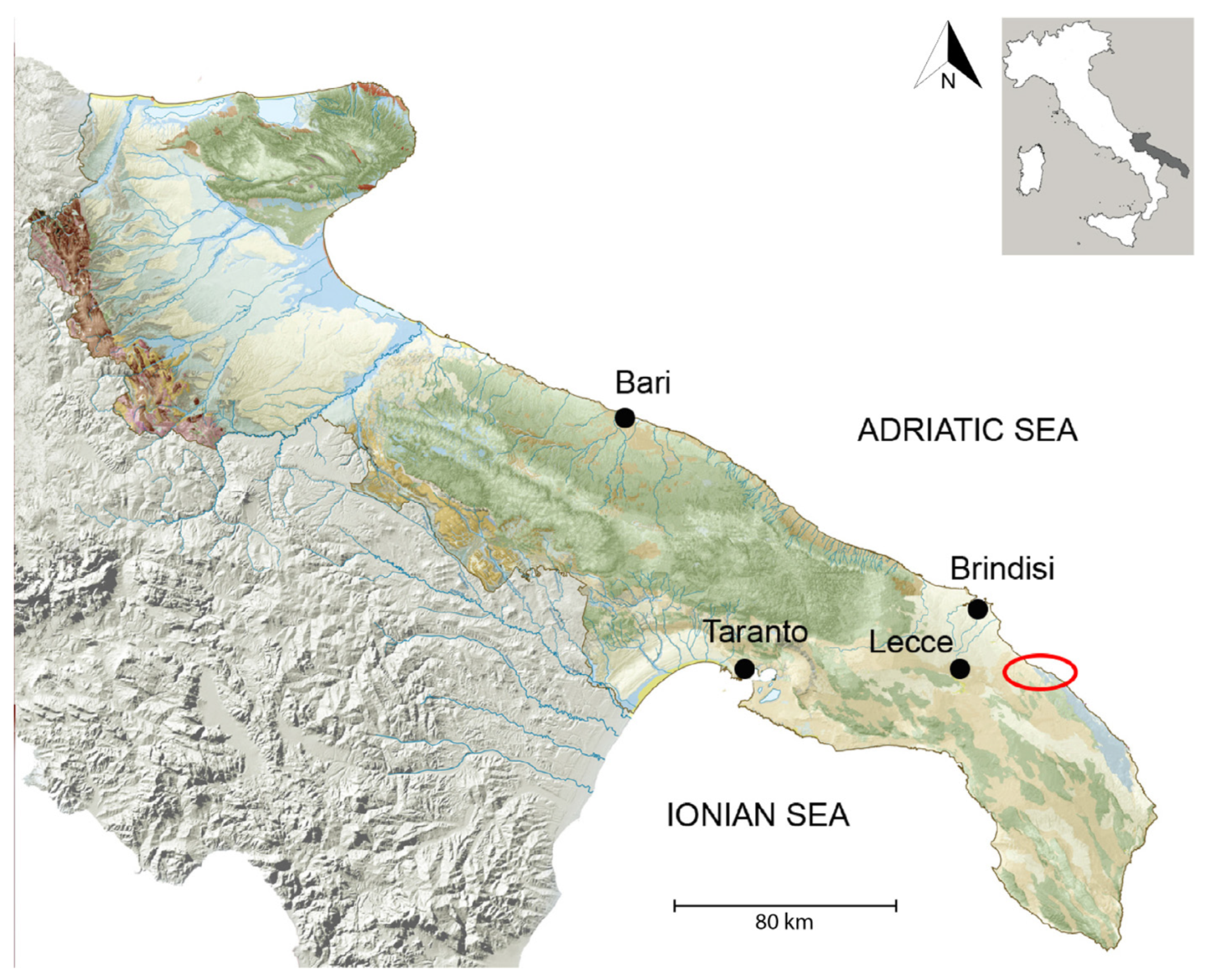
3. Regional Setting
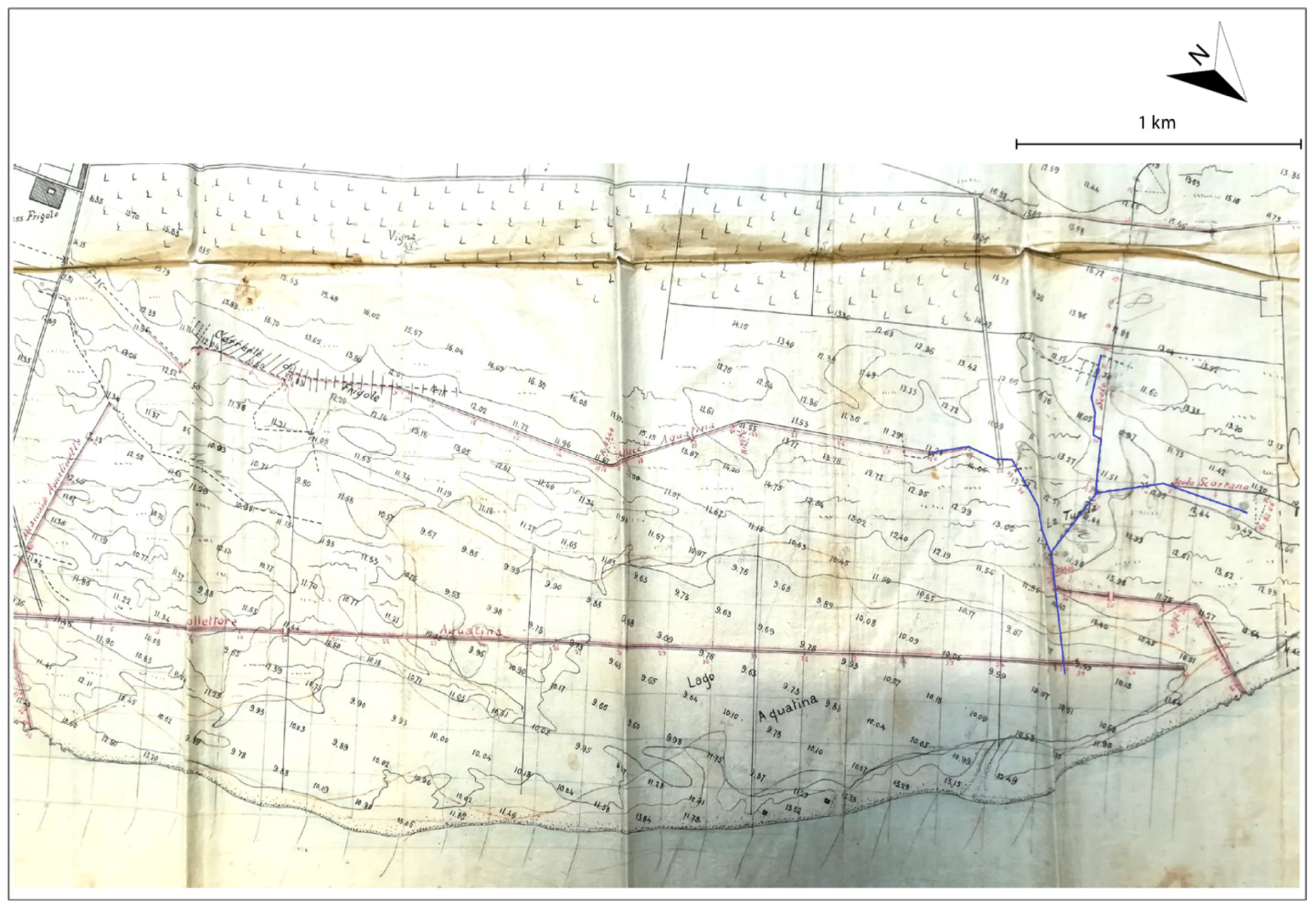
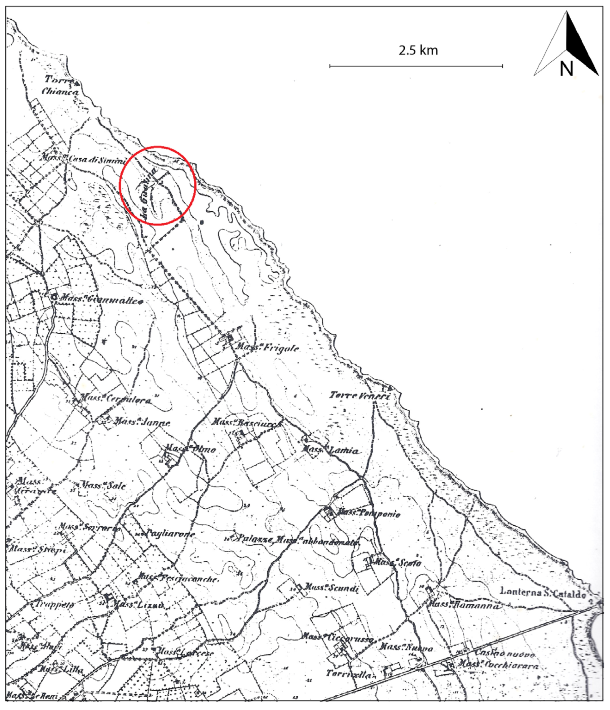
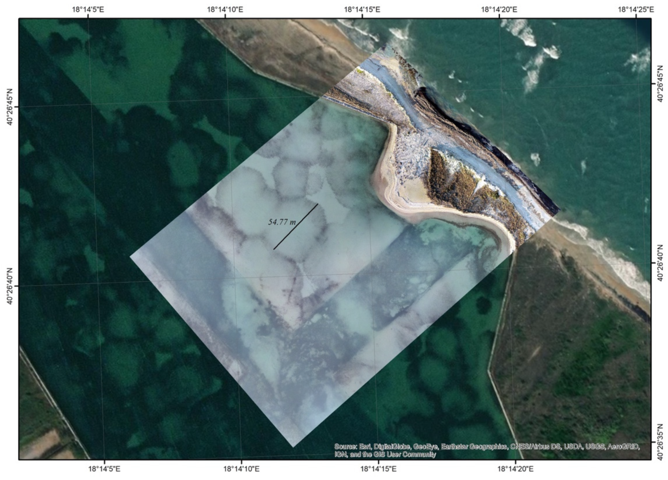
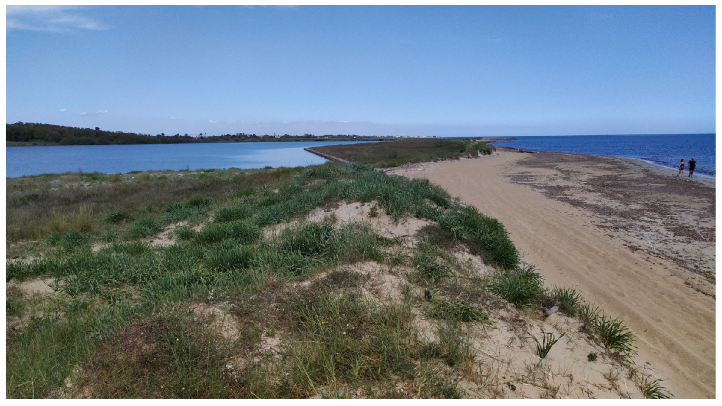
3.1. The Acquatina di Frigole Site: History
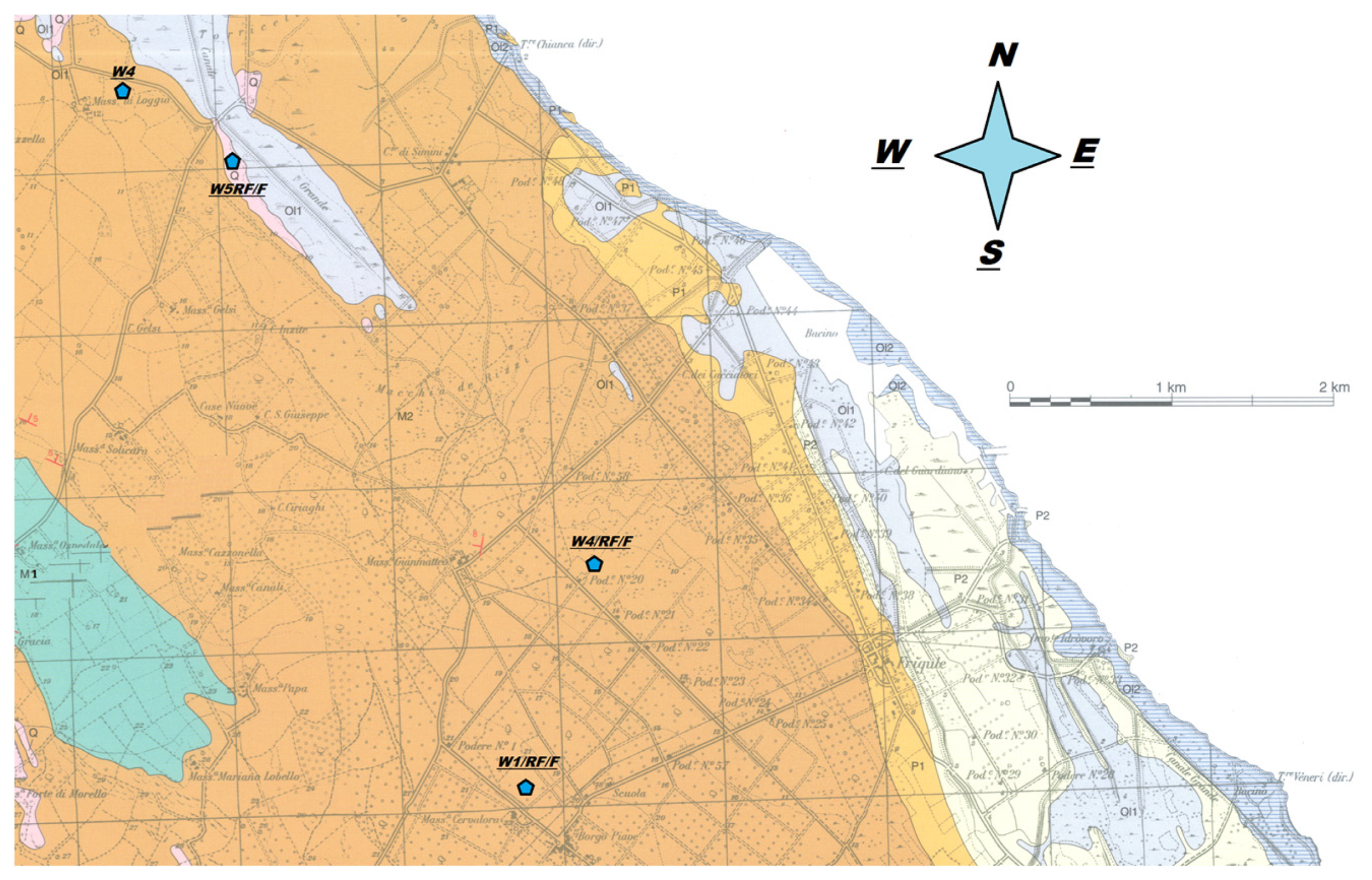
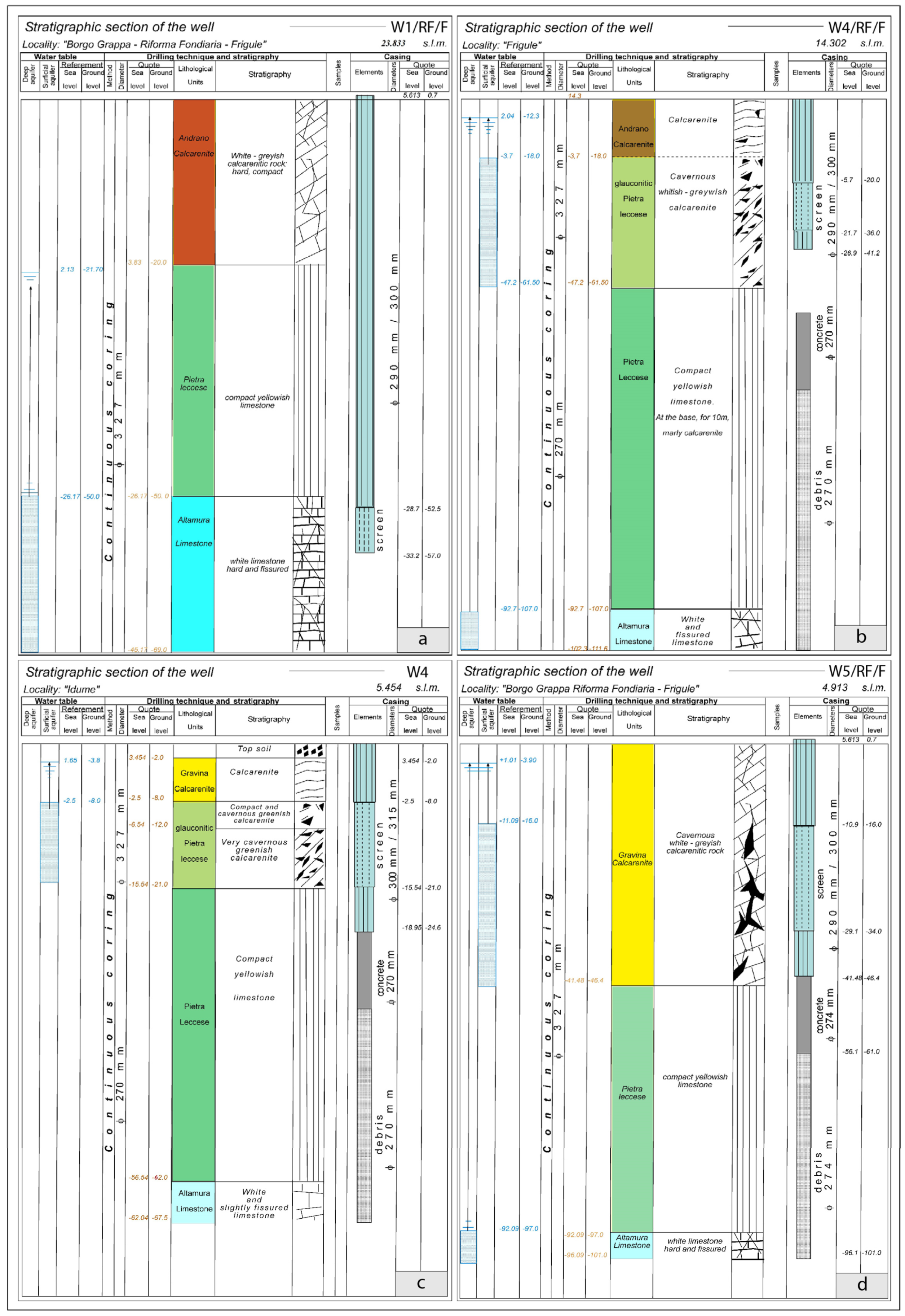
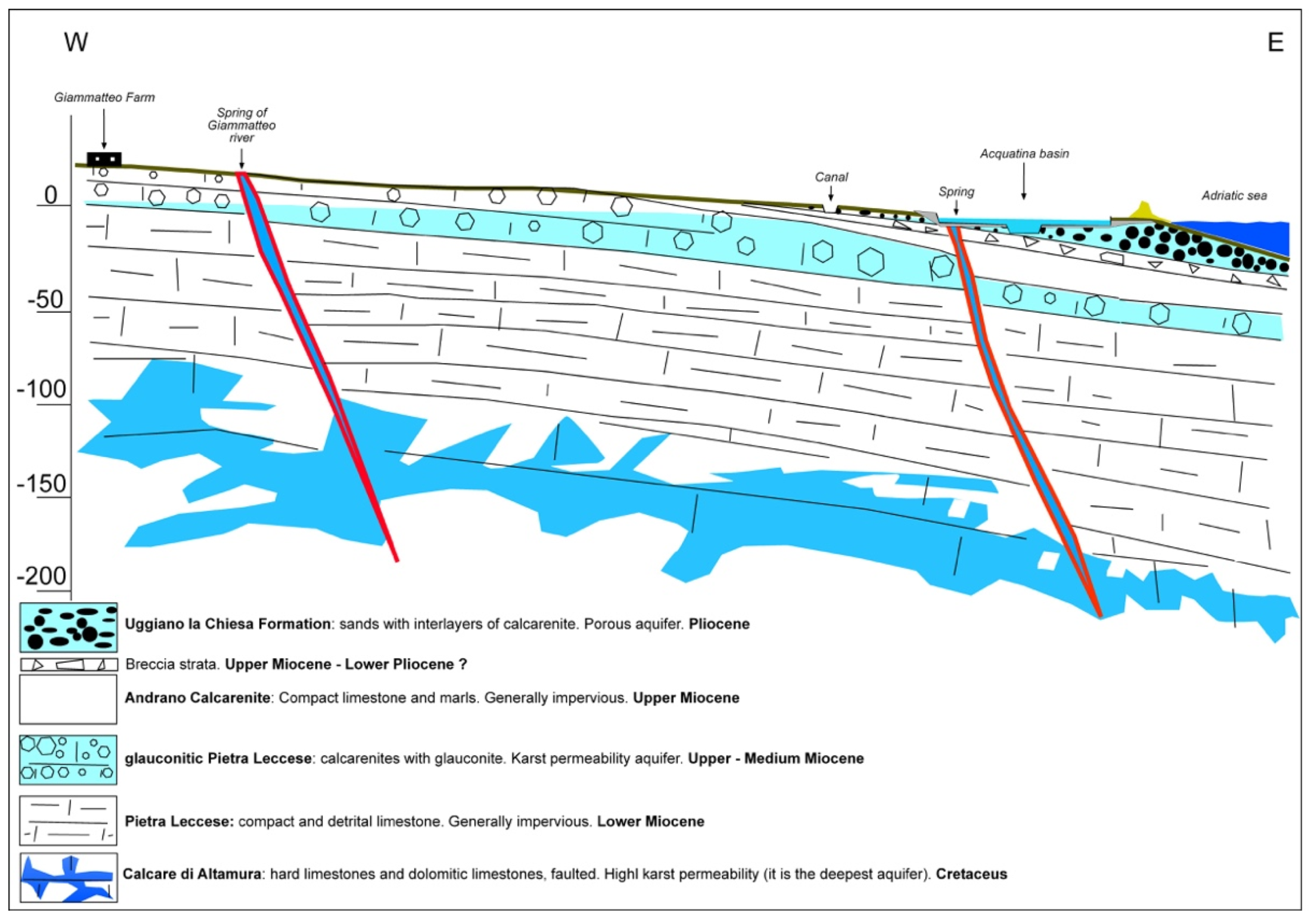
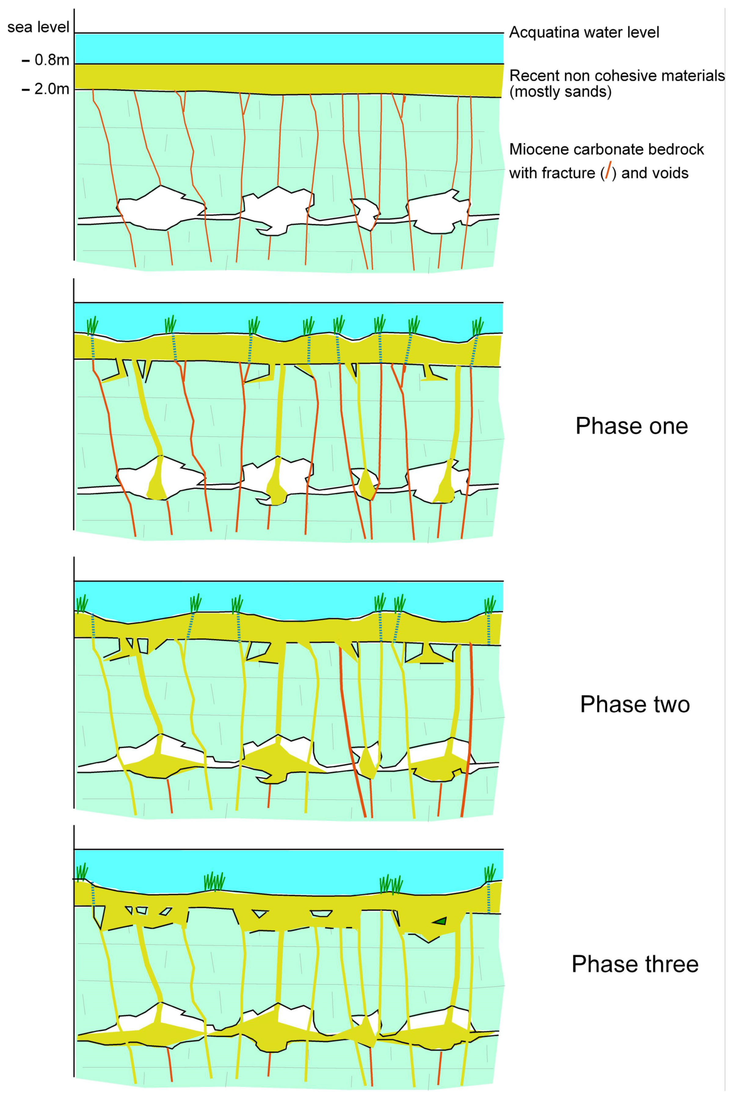
3.2. Hydro-Stratigraphy
4. Results
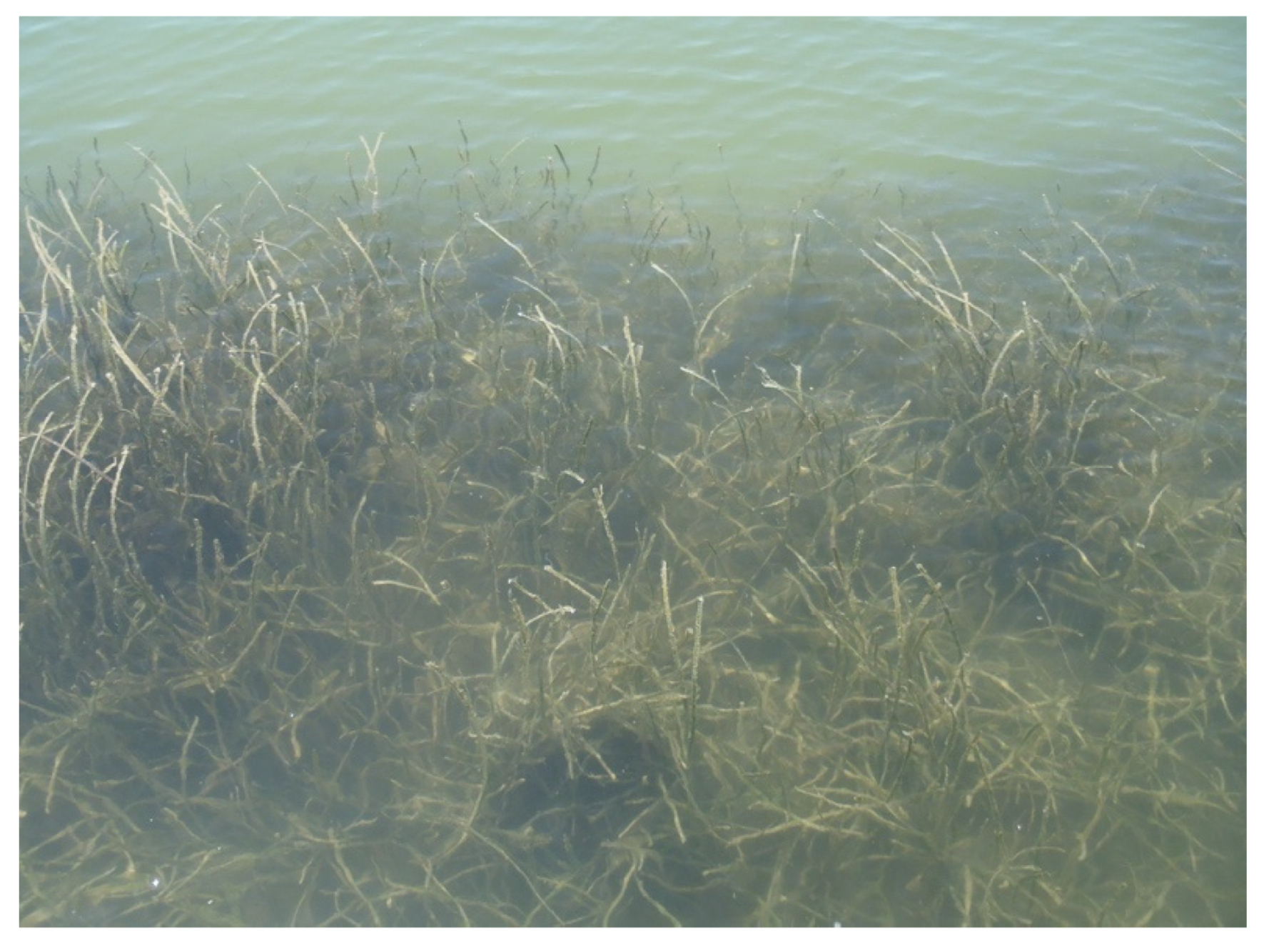
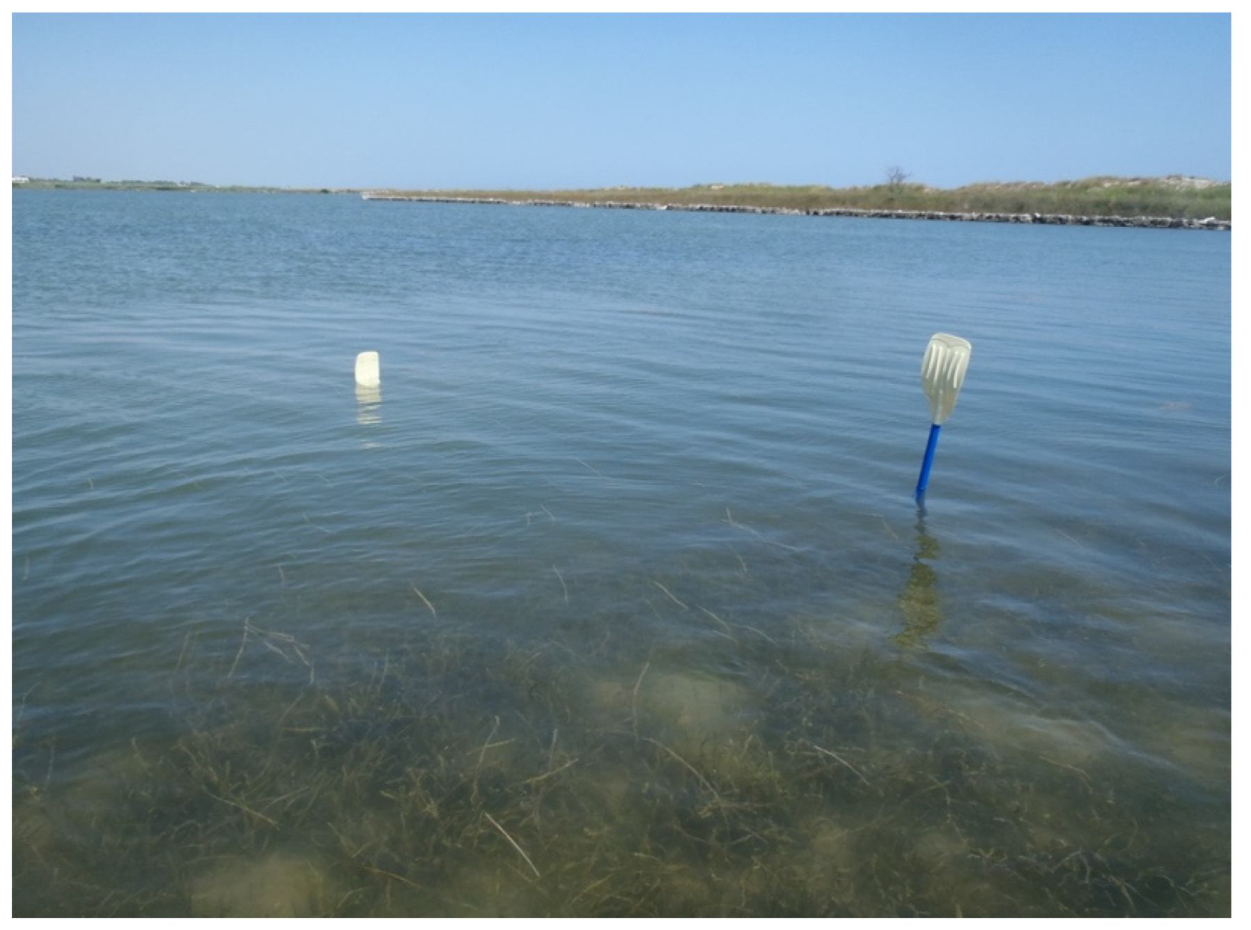
4.1. Ecology
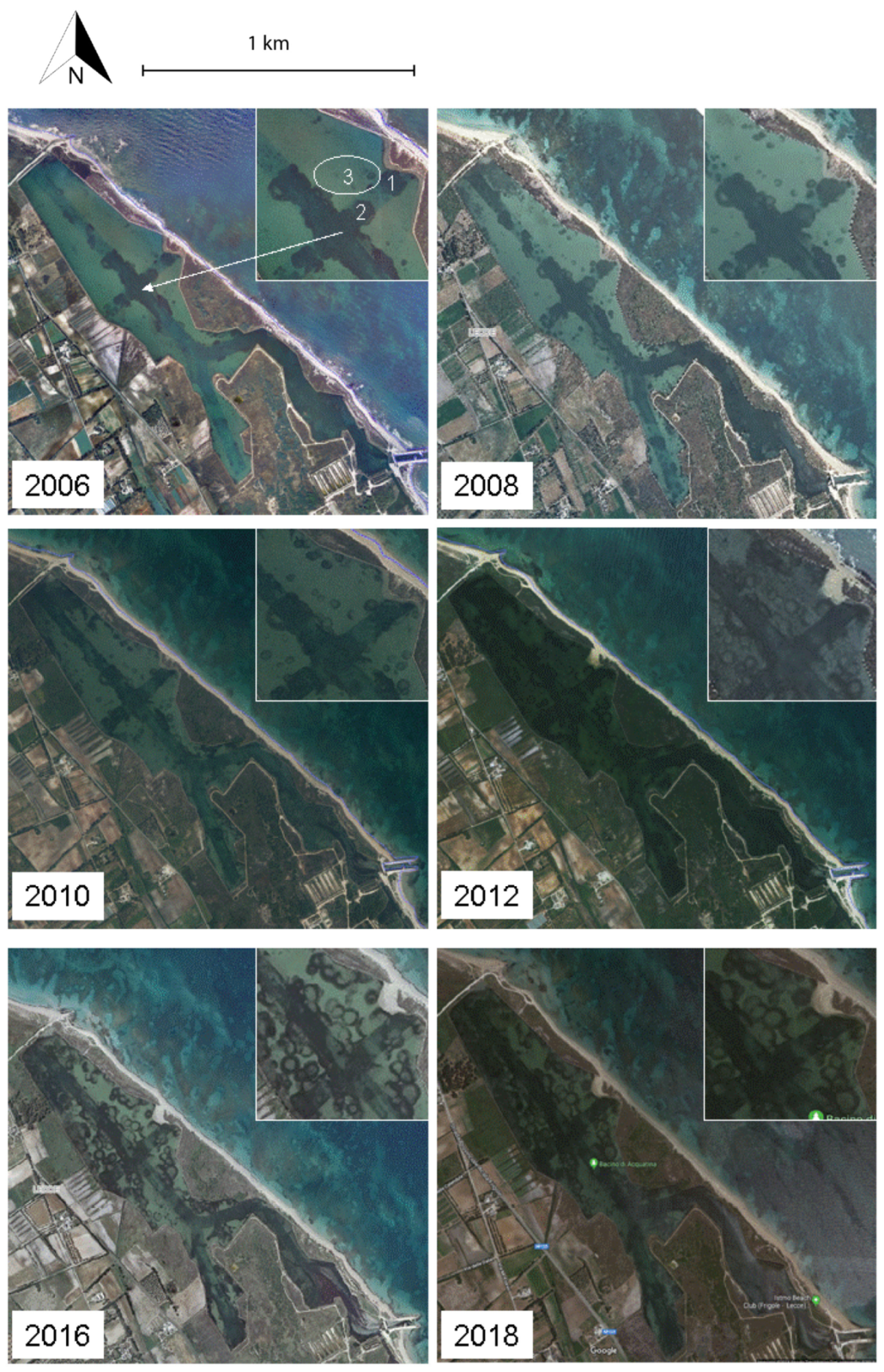
4.2. Sinkhole Evolution
5. Discussion
6. Conclusions and Future Perspectives
Author Contributions
Funding
Data Availability Statement
Acknowledgments
Conflicts of Interest
References
- Waltham, T.; Bell, F.; Culshaw, M. Sinkholes and Subsidence: Karst and Cavernous Rocks in Engineering and Construction; Springer: Berlin/Heidelberg, Germany, 2005. [Google Scholar]
- Gutierrez, F.; Parise, M.; De Waele, J.; Jourde, H. A review on natural and human-induced geohazards and impacts in karst. Earth Sci. Rev. 2014, 138, 61–88. [Google Scholar] [CrossRef]
- Parise, M. Sinkholes. In Encyclopedia of Caves, 3rd ed.; White, W.B., Culver, D.C., Pipan, T., Eds.; Academic Press: Cambridge, MA, USA; Elsevier: Amsterdam, The Netherlands, 2019; pp. 934–942. [Google Scholar]
- Parise, M. A present risk from past activities: Sinkhole occurrence above underground quarries. Carbonates Evaporites 2012, 27, 109–118. [Google Scholar] [CrossRef]
- Gil, H.; Pepe, M.; Soriano, M.A.; Parise, M.; Pocovì, A.; Luzon, A.; Perez, A.; Basso, A. Sviluppo ed evoluzione di sprofondamenti in rocce solubili: Un confronto tra il carso coperto del Bacino dell’Ebro (Spagna) e la Penisola Salentina (Italia). Mem. Descr. Della Carta Geol. D’italia 2013, 93, 253–276. [Google Scholar]
- Margiotta, S.; Negri, S.; Parise, M.; Quarta, T. Karst geosites at risk of collapse: The sinkholes at Nociglia (Apulia, SE Italy). Environ. Earth Sci. 2016, 75, 8. [Google Scholar] [CrossRef]
- Advances in Karst Research: Theory, Fieldwork and Applications; Parise, M.; Gabrovsek, F.; Kaufmann, G.; Ravbar, N. (Eds.) Special Publication, 466; Geological Society: London, UK, 2018. [Google Scholar]
- Zumpano, V.; Pisano, L.; Parise, M. An integrated framework to identify and analyze karst sinkholes. Geomorphology 2019, 332, 213–225. [Google Scholar] [CrossRef]
- Ford, D.C.; Williams, P. Karst Hydrogeology and Geomorphology; Wiley: Chichester, UK, 2007. [Google Scholar]
- Sauro, U. Dolines and sinkholes: Aspects of evolution and problems of classification. Acta Carsologica 2003, 32, 41–52. [Google Scholar] [CrossRef] [Green Version]
- De Waele, J.; Gutiérrez, F.; Parise, M.; Plan, L. Geomorphology and natural hazards in karst areas: A review. Geomorphology 2007, 134, 1–8. [Google Scholar] [CrossRef]
- Natural and Anthropogenic Hazards in Karst Areas: Recognition, Analysis and Mitigation; Parise, M.; Plan, L. (Eds.) Special Publication, 279; Geological Society: London, UK, 2007. [Google Scholar]
- Gutiérrez-Santolalla, F.; Gutiérrez-Elorza, M.; Marín, C.; Desir, G.; Maldonado, C. Spatial distribution, morphometry and activity of La Puebla de Alfindén sinkhole field in the Ebro river valley (NE Spain): Applied aspects for hazard zonation. Environ. Geol. 2005, 48, 360–369. [Google Scholar] [CrossRef]
- Farrant, A.; Cooper, A. Karst geohazards in the UK: The use of digital data for hazard management. Q. J. Eng. Geol. Hydrogeol. 2008, 41, 339–356. [Google Scholar] [CrossRef]
- Heidari, M.; Khanlari, G.R.; Taleb Beydokhti, A.R.; Momeni, A.A. The formation of cover collapse sinkholes in North of Hamedan, Iran. Geomorphology 2011, 132, 76–86. [Google Scholar] [CrossRef]
- Zhou, W.; Beck, B.F. Engineering issues in karst. In Karst Management; Van Beynen, P., Ed.; Springer: Berlin/Heidelberg, Germany, 2011; pp. 9–45. [Google Scholar]
- Galve, J.P.; Castañeda, C.; Gutiérrez, F. Railway deformation detected by DInSAR over active sinkholes in the Ebro Valley evaporite karst, Spain. Nat. Hazards Earth Syst. Sci. 2015, 15, 2439–2448. [Google Scholar] [CrossRef] [Green Version]
- Zini, L.; Calligaris, C.; Forte, E.; Petronio, L.; Zavagno, E.; Boccali, C.; Cucchi, F. A multidisciplinary approach in sinkhole analysis: The Quinis village case study (NE-Italy). Eng. Geol. 2015, 197, 132–144. [Google Scholar] [CrossRef]
- Lei, M.; Gao, Y.; Jiang, X.; Guan, Z. Mechanism analysis of sinkhole formation at Maohe village, Liuzhou city, Guangxi province, China. Environ. Earth Sci. 2016, 75, 542. [Google Scholar] [CrossRef]
- Szűcs, E.; Gönczy, S.; Bozsó, I.; Bányai, L.; Szakacs, A.; Szárnya, C.; Wesztergom, V. Evolution of surface deformation related to salt-extraction-caused sinkholes in Solotvyno (Ukraine) revealed by Sentinel-1 radar interferometry. Nat. Hazards Earth Syst. Sci. 2021, 21, 977–993. [Google Scholar] [CrossRef]
- Mastronuzzi, G.; Valletta, S.; Damiani, A.; Fiore, A.; Francescangeli, R.; Giandonato, P.B.; Iurilli, V.; Sabato, L. Geositi della Puglia; Graphic Concept Lab: Bari, Italy, 2015; p. 394. [Google Scholar]
- Hose, T.A. Geo-tourism—Appreciating the deep side of landscapes. In Niche Tourism: Contemporary Issues, Trends and Cases; Novelli, M., Ed.; Elsevier: New York, NY, USA, 2005; pp. 27–37. [Google Scholar]
- Dowling, R.K.; Newsome, D. Geotourism; Elsevier: Oxford, UK, 2006. [Google Scholar]
- Newsome, D.; Dowling, R.K. Geotourism: The Tourism of Geology and Landscape; Goodfellow Publishers: Oxford, UK, 2010. [Google Scholar]
- Sansò, P.; Margiotta, S.; Mastronuzzi, G.; Vitale, A. The geological heritage of Salento Leccese (Apulia, southern Italy). Geoheritage 2015, 7, 85–101. [Google Scholar] [CrossRef]
- Margiotta, S.; Sansò, P. Otranto Leuca coast Geopark (Salento, Italy): A proposal for the institution. Geoheritage 2014, 6, 305–316. [Google Scholar] [CrossRef]
- Margiotta, S.; Sansò, P. Abandoned Quarries and Geotourism: An Opportunity for the Salento Quarry District (Apulia, Southern Italy). Geoheritage 2017, 9, 463–477. [Google Scholar]
- Fidelibus, M.D.; Pellicani, R.; Argentiero, I.; Spilotro, G. The Geoheritage of the Water Intake of Triglio Ancient Aqueduct (Apulia Region, Southern Italy): A Lesson of Advanced Technology Insensitive to Climate Changes from an Ancient Geosite. Geoheritage 2018, 10, 327–339. [Google Scholar] [CrossRef]
- Margiotta, S.; Parise, M. Hydraulic and Geomorphological Hazards at Wetland Geosites Along the Eastern Coast of Salento (SE Italy). Geoheritage 2019, 11, 1655–1666. [Google Scholar] [CrossRef]
- Liso, I.S.; Chieco, M.; Fiore, A.; Pisano, L.; Parise, M. Underground geosites and caving speleotourism: Some considerations, from a case study in Southern Italy. Geoheritage 2020, 12, 13. [Google Scholar] [CrossRef]
- Parise, M.; Lollino, P. A preliminary analysis of failure mechanisms in karst and man-made underground caves in Southern Italy. Geomorphology 2011, 134, 132–143. [Google Scholar] [CrossRef]
- Parise, M. A procedure for evaluating the susceptibility to natural and anthropogenic sinkholes. Georisk 2015, 9, 272–285. [Google Scholar] [CrossRef]
- Fiore, A.; Parise, M. Cronologia degli eventi di sprofondamento in Puglia, con particolare riferimento alle interazioni con l’ambiente antropizzato. Mem. Descr. Della Carta Geol. D’italia 2013, 93, 239–252. [Google Scholar]
- Parise, M.; Vennari, C. A chronological catalogue of sinkholes in Italy: The first step toward a real evaluation of the sinkhole hazard. In Proceedings of the 13th Multidisciplinary Conference on Sinkholes and the Engineering and Environmental Impacts of Karst, Carlsbad, NM, USA, 6–10 May 2013; pp. 383–392. [Google Scholar]
- Parise, M.; Vennari, C. Distribution and features of natural and anthropogenic sinkholes in Apulia. In EuroKarst 2016, Neuchatel. Advances in the Hydrogeology of Karst and Carbonate Reservoirs; Renard, P., Bertrand, C., Eds.; Springer: Berlin/Heidelberg, Germany, 2017; pp. 27–34. [Google Scholar]
- Taviani, M.; Angeletti, L.; Campiani, E.; Ceregato, A.; Foglini, F.; Maseli, V.; Morsilli, M.; Parise, M.; Trincardi, F. Drowned karst landscape offshore the Apulian Margin (Southern Adriatic Sea, Italy). J. Cave Karst Stud. 2012, 74, 197–212. [Google Scholar] [CrossRef]
- Margiotta, S.; Negri, S.; Parise, M.; Valloni, R. Mapping the susceptibility to sinkholes in coastal areas, based on stratigraphy, geomorphology and geophysics. Nat. Hazards 2012, 62, 657–676. [Google Scholar] [CrossRef]
- Norris, R.M.; Back, W. Erosion of seacliffs by groundwater. In Groundwater Geomorphology: The Role of Subsurface Water in Earth-Surface Processes and Landforms; Higgins, C.G., Coates, D.R., Eds.; Special Paper 252; Geological Society of America: Boulder, CO, USA, 1990; pp. 283–290. [Google Scholar]
- White, W.B. Surface and near-surface karst landforms. In Groundwater Geomorphology: The Role of Subsurface Water in Earth-Surface Processes and Landforms; Higgins, C.G., Coates, D.R., Eds.; Special Paper 252; Geological Society of America: Boulder, CO, USA, 1990; pp. 157–175. [Google Scholar]
- Forth, R.A.; Butcher, D.; Senior, R. Hazard mapping of karst along the coast of the Algarve, Portugal. Eng. Geol. 1999, 52, 67–74. [Google Scholar] [CrossRef]
- Closson, D.; Karaki, N.A.; Klinger, Y.; Hussein, M.J. Subsidence and sinkhole hazards assessment in the southern Dead Sea area, Jordan. Pure Appl. Geophys. 2005, 162, 221–248. [Google Scholar] [CrossRef]
- Closson, D.; Karaki, N.A.; Milisavljevic, N.; Hallot, F.; Acheroy, M. Salt-dissolution induced subsidence in the Dead Sea area detected by applying interferometric techniques to ALOS Palsar Synthetic Aperture Radar images. Geodin. Acta 2010, 23, 65–78. [Google Scholar] [CrossRef] [Green Version]
- Ezersky, M.; Legchenko, A.; Camerlynck, C.; Al-Zoubi, A. Identification of sinkhole development mechanism based on a combined geophysical study in Nahal Hever South area (Dead Sea coast of Israel). Environ. Geol. 2009, 58, 1123–1141. [Google Scholar] [CrossRef]
- Frumkin, A.; Ezersky, M.; Al-Zoubi, A.; Akkawi, E.; Abueladas, A.R. The Dead Sea sinkhole hazard: Geophysical assessment of salt dissolution and collapse. Geomorphology 2011, 134, 1102–1117. [Google Scholar] [CrossRef]
- Bruno, E.; Calcaterra, D.; Parise, M. Development and morphometry of sinkholes in coastal plains of Apulia, southern Italy. Preliminary sinkhole susceptibility assessment. Eng. Geol. 2008, 99, 198–209. [Google Scholar]
- Basso, A.; Bruno, E.; Parise, M.; Pepe, M. Morphometric analysis of sinkholes in a karst coastal area of southern Apulia (Italy). Environ. Earth Sci. 2013, 70, 2545–2559. [Google Scholar] [CrossRef]
- Bogli, A. Mischungkorrosion—Ein Beitrag zum Verstärkungsproblem. Erdkunde 1964, 18, 83–92. [Google Scholar] [CrossRef]
- Cigna, A.A.; Forti, P. The speleogenetic role of the air flow caused by convection. Int. J. Speleol. 1986, 15, 41–52. [Google Scholar] [CrossRef] [Green Version]
- Dreybrodt, W. Processes in Karst Systems: Physics, Chemistry, and Geology; Springer: Berlin/Heidelberg, Germany, 1988. [Google Scholar]
- Lace, M.J.; Mylroie, J.E. Coastal Karst Landforms; Springer: Berlin/Heidelberg, Germany, 2013. [Google Scholar]
- Trudgill, S.T. The marine erosion of limestones on Aldabra Atoll, Indian Ocean. Z. Fur Geomorphol. 1976, 26, 164–200. [Google Scholar]
- Day, M. Doline morphology and development in Barbados. Ann. Assoc. Am. Geogr. 1983, 73, 206–219. [Google Scholar] [CrossRef]
- Back, W.; Hanshaw, B.B.; Herman, J.S.; Van Driel, J.N. Differential dissolution of a Pleistocene reef in the ground-water mixing zone of coastal Yucatan, Mexico. Geology 1986, 14, 137–140. [Google Scholar] [CrossRef]
- Baceta, J.I.; Wright, V.P.; Pujalte, V. Palaeo-mixing zone karst features from Palaeocene carbonates of north Spain: Criteria for recognizing a potentially widespread but rarely documented diagenetic system. Sediment. Geol. 2001, 139, 205–216. [Google Scholar] [CrossRef]
- Palmer, A.N. Cave Geology; Cave Books: Dayton, OH, USA, 2007. [Google Scholar]
- Karst Rock Features—Karren Sculpturing; Gines, A.; Knez, M.; Slabe, T.; Dreybrodt, W. (Eds.) Carstologia 9; Zalozba ZRC/ZRC Publishing: Ljubljana, Slovenia, 2009. [Google Scholar]
- Beccarisi, L.; Ernandes, P.; Delle Rose, M.; Zuccarello, V. Valutazione dello stato di conservazione delle “spunnulate” della costa di Porto Cesareo e Nardò (provincia di Lecce) con un approccio vegetazionale. Thalass. Salentina 2006, 29, 215–236. [Google Scholar]
- Denitto, F.; Moscatello, S.; Palmisano, P.; Poto, M.; Onorato, R. Novità speleologiche, idrologiche e naturalistiche dalla Palude del Capitano (pSIC IT9150013), Costa Neretina (Lecce). Thalass. Salentina 2006, 29, 99–116. [Google Scholar]
- Onorato, R.; Belmonte, G.; Costantini, A. Le grotte sommerse della costa neretina (Salento, SE Italia). Thalass. Salentina 2006, 29, 39–54. [Google Scholar]
- Onorato, M.; Onorato, R.; Posi, M.E.; Poto, M. La Spunnulata della Pajara. Esplorazione e prime osservazioni. Thalass. Salentina 2017, 39, 73–82. [Google Scholar]
- Belmonte, G.; Costantini, A.; Sorrentino, F.; Licchelli, C.; Poto, M.; Onorato, R. Le grotte sommerse dell’Area Marina Protetta “Porto Cesareo”. Thalass. Salentina 2011, 33, 15–38. [Google Scholar]
- Parise, M.; Palmisano, P.; Onorato, R. Contributo alla conoscenza dei fenomeni carsici di collasso in zone costiere del Salento Jonico (Puglia): La Spunnulata della Pajara. Thalass. Salentina 2017, 39, 99–122. [Google Scholar]
- Delle Rose, M.; Parise, M. Karst subsidence in south-central Apulia Italy. Int. J. Speleol. 2002, 31, 181–199. [Google Scholar] [CrossRef] [Green Version]
- Delle Rose, M.; Federico, A.; Parise, M. Sinkhole genesis and evolution in Apulia, and their interrelations with the anthropogenic environment. Nat. Hazards Earth Sys. Sci. 2004, 4, 747–755. [Google Scholar] [CrossRef] [Green Version]
- Parise, M. I sinkholes in Puglia. Mem. Descr. Della Carta Geol. D’italia 2008, 85, 309–334. [Google Scholar]
- Parise, M. Surface and sub-surface karst geomorphology in the Murge (Apulia, southern Italy). Acta Carsologica 2011, 40, 79–93. [Google Scholar] [CrossRef]
- Del Prete, S.; Di Crescenzo, G.; Santangelo, N.; Santo, A. Collapse sinkholes in Campania (southern Italy): Predisposing factors, genetic hypothesis and susceptibility. Z. Geomorph. 2010, 54, 259–284. [Google Scholar] [CrossRef]
- Del Prete, S.; Iovine, G.; Parise, M.; Santo, A. Origin and distribution of different types of sinkholes in the plain areas of Southern Italy. Geodin. Acta 2010, 23, 113–127. [Google Scholar] [CrossRef]
- Festa, V.; Fiore, A.; Parise, M.; Siniscalchi, A. Sinkhole evolution in the Apulian karst of southern Italy: A case study, with some considerations on sinkhole hazards. J. Cave Karst Stud. 2012, 74, 137–147. [Google Scholar] [CrossRef]
- Martinotti, M.E.; Pisano, L.; Marchesini, I.; Rossi, M.; Peruccacci, S.; Brunetti, M.T.; Melillo, M.; Amoruso, G.; Loiacono, P.; Vennari, C.; et al. Landslides, floods and sinkholes in a karst environment: The 1–6 September 2014 Gargano event, southern Italy. Nat. Hazards Earth Syst. Sci. 2017, 17, 467–480. [Google Scholar] [CrossRef] [Green Version]
- Calcaterra, D.; Parise, M. The contribution of historical information in the assessment of the landslide hazard. In The Use of Historical Data in Natural Hazard Assessments; Glade, T., Albini, P., Frances, F., Eds.; Advances in Natural and Technological Hazards Research, 17; Kluwer Academic Publishers: Amsterdam, The Netherlands, 2001; pp. 201–217. [Google Scholar]
- The Use of Historical Data in Natural Hazard Assessments; Glade, T.; Albini, P.; Frances, F. (Eds.) Advances in Natural and Technological Hazards Research, 17; Kluwer Academic Publishers: Amsterdam, The Netherlands, 2001. [Google Scholar]
- Parise, M.; Federico, A.; Delle Rose, M.; Sammarco, M. Karst terminology in Apulia (Southern Italy). Acta Carsologica 2003, 32, 65–82. [Google Scholar] [CrossRef]
- Delle Rose, M.; Parise, M. Water management in the karst of Apulia, southern Italy. In Sustainability of the Karst Environment. Dinaric Karst and Other Karst Regions, Proceedings of the International Interdisciplinary Scientific Conference, India, 2–4 December 2010; Bonacci, O., Ed.; Series on Groundwater no. 2; IHP-UNESCO: Paris, France, 2010; pp. 33–40. [Google Scholar]
- Pepe, M.; Parise, M. Structural control on development of karst landscape in the Salento Peninsula (Apulia, SE Italy). Acta Carsologica 2014, 43, 101–114. [Google Scholar] [CrossRef]
- Ciaranfi, N.; Pieri, P.; Ricchetti, G. Note alla Carta Geologica delle Murge e del Salento (Puglia centro-meridionale). Mem. Della Soc. Geol. Ital. 1988, 41, 449–460. [Google Scholar]
- Tozzi, M.; Kissel, C.; Funiciello, R.; Laj, C.; Parotto, M. A clockwise rotation of southern Apulia? Geophys. Res. Lett. 1988, 15, 681–684. [Google Scholar] [CrossRef]
- Ricchetti, G.; Ciaranfi, N.; Luperto Sinni, E.; Mongelli, F.; Pieri, P. Geodinamica ed evoluzione sedimentaria e tettonica dell’Avampaese Apulo. Mem. Della Soc. Geol. Ital. 1988, 41, 57–82. [Google Scholar]
- Doglioni, C.; Mongelli, F.; Pieri, P. The Puglia uplift (SE Italy): An anomaly in the foreland of the Apenninic subduction due to buckling of a thick continental lithosphere. Tectonics 1994, 13, 1309–1321. [Google Scholar] [CrossRef]
- Pieri, P.; Festa, V.; Moretti, M.; Tropeano, M. Quaternary tectonic of the Murge area (Apulian foreland—Southern Italy). Ann. Di Geofis. 1997, 40, 1395–1404. [Google Scholar]
- Margiotta, S.; Negri, S. Geophysical and stratigraphical research into deep groundwater and intruding seawater in the Mediterranean area (the Salento peninsula, Italy). Nat. Hazards Earth Syst. Sci. 2005, 5, 127–136. [Google Scholar] [CrossRef]
- Giudici, M.; Margiotta, S.; Mazzone, F.; Negri, S.; Vassena, C. Modelling hydrostratigraphy and groundwater flow of a fractured and karst aquifer in a Mediterranean basin (Salento peninsula, southeastern Italy). Environ. Earth Sci. 2012, 67, 1891–1907. [Google Scholar] [CrossRef]
- Cotecchia, V. Le acque sotterranee e l’intrusione marina in Puglia: Dalla ricerca all’emergenza nella salvaguardia della risorsa. Mem. Descr. Carta Geol. D’italia 2014, 92, 1–416. [Google Scholar]
- Masciopinto, C.; Liso, I.S.; Caputo, M.C.; De Carlo, L. An integrated approach based on numerical modelling and geophysical survey to map groundwater salinity in fractured coastal aquifers. Water 2017, 9, 875. [Google Scholar] [CrossRef] [Green Version]
- Cotecchia, V. Sulle caratteristiche delle sorgenti e sulle modalità di rinvenimento della falda profonda nella Penisola Salentina in rapporto alla struttura dei calcari cretacici della regione. Ann. Della Fac. Di Ing. 1956, 2, 88–101. [Google Scholar]
- Cotecchia, V. Sviluppi della teoria di Ghyben ed Herzberg nello studio idrogeologico dell’alimentazione e dell’impiego delle falde acquifere, con riferimento a quella profonda delle Murge e del Salento. Geotecnica 1958, 6, 301–318. [Google Scholar]
- Orabona, E.; Cotecchia, V. La stratificazione salina nella falde con superfici di fondo rappresentate dall’acqua di marina e precisazioni sul comportamento idraulico dei pozzi relativi a siffatte falde. Ing. Sanit. 1959, 1, 1–15. [Google Scholar]
- Cotecchia, V. Studi e ricerche sulle acque sotterranee e sull’intrusione marina in Puglia (Penisola Salentina). Quad. Ist. Ric. Acque 1977, 20, 25–29. [Google Scholar]
- Cotecchia, V.; Tadolini, T.; Tulipano, L. Sea water intrusion in the planning of groundwater resources protection and utilization in the Apulia region (Southern Italy). Geol. Appl. Idrogeol. 1983, 18, 367–382. [Google Scholar]
- Liso, I.S.; Parise, M. Apulian karst springs: A review. J. Environ. Sci. Eng. Technol. 2020, 8, 63–83. [Google Scholar]
- Cotecchia, V.; Scuro, M.; Mezzina, G. Depletetion of the Cretacic Carbonate aquifer in Salento peninsula (Southeastern Italy): The case of Chidro Spring. Eng. Geol. Soc. Terit. 2015, 2, 105–109. [Google Scholar]
- Portoghese, I.; Masciale, R.; Caputo, M.C.; De Carlo, L.; Malcangio, D. Combined Discharge and Thermo-Salinity Measurements for the Characterization of a Karst Spring System in Southern Italy. Sustainability 2020, 12, 3311. [Google Scholar] [CrossRef] [Green Version]
- Margiotta, S. Idume e Altre Storie D’acqua; Primiceri Editore: Padova, Italy, 2020. [Google Scholar]
- D’Angeli, I.M.; Vattano, M.; Parise, M.; De Waele, J. The coastal sulfuric acid cave system of Santa Cesarea Terme (Southern Italy). In Hypogene Karst Regions and Caves of the World; Klimchouk, A., Palmer, A.N., De Waele, J., Auler, A.S., Audra, P., Eds.; Cave and Karst Systems of the World; Springer: Berlin/Heidelberg, Germany, 2017; pp. 161–168. [Google Scholar]
- D’Angeli, I.M.; Parise, M.; Vattano, M.; Madonia, G.; Galdenzi, S.; De Waele, J. Sulfuric acid caves of Italy: A review. Geomorphology 2019, 333, 105–122. [Google Scholar] [CrossRef]
- D’Angeli, I.M.; De Waele, J.; Fiorucci, A.; Vigna, B.; Bernasconi, S.M.; Florea, L.J.; Liso, I.S.; Parise, M. Hydrogeology and geochemistry of the sulfur karst springs at Santa Cesarea Terme (Apulia, southern Italy). Hydrogeol. J. 2021, 29, 481–498. [Google Scholar] [CrossRef]
- Alfio, M.R.; Balacco, G.; Parisi, A.; Totaro, V.; Fidelibus, M.D. Drought Index as Indicator of Salinization of the Salento Aquifer (Southern Italy). Water 2020, 12, 1927. [Google Scholar] [CrossRef]
- De Filippis, G.; Foglia, L.; Giudici, M.; Mehl, S.; Margiotta, S.; Negri, S. Seawater intrusion in karstic, coastal aquifers: Current challenges and future scenarios in the Taranto area (southern Italy). Sci. Total Environ. 2016, 573, 1340–1351. [Google Scholar] [CrossRef] [PubMed]
- De Filippis, G.; Foglia, L.; Giudici, M.; Mehl, S.; Margiotta, S.; Negri, S. Effects of different boundary conditions on the simulation of groundwater flow in a multi-layered coastal aquifer system (Taranto Gulf, southern Italy). Hydrogeol. J. 2017, 25, 2123–2138. [Google Scholar] [CrossRef]
- De Filippis, G.; Margiotta, S.; Caruso, F.; Negri, S.L. Open questions about the hydrodynamic behaviour deep coastal aquifer of the Salento peninsula (south eastern Italy): Coupling knowledge expert data and numerical modelling for testing hydrogeological conceptuals models. Sci. Total Environ. 2020, 715, 136962. [Google Scholar] [CrossRef]
- Fidelibus, M.; Calò, G.; Tinelli, R.; Tulipano, L. Salt ground waters in the Salento karstic coastal aquifer (Apulia, Southern Italy). In Advances in the Research of Aquatic Environment; Lambrakis, N., Stournaras, G., Katsanou, K., Eds.; Environmental Earth Science Series; Springer: Berlin/Heidelberg, Germany, 2011; Volume 1, pp. 407–415. [Google Scholar] [CrossRef]
- Polemio, M.; Dragone, V.; Limoni, P.P. Monitoring and methods to analyse the groundwater quality degradation risk in coastal karstic aquifers (Apulia, southern Italy). Environ. Geol. 2009, 58, 299–312. [Google Scholar] [CrossRef] [Green Version]
- Regione Puglia—Servizio Tutela delle Acque. Piano di Tutela Delle Acque (PTA); Regione Puglia: Bari, Italy, 2009. [Google Scholar]
- Romanazzi, A.; Gentile, F.; Polemio, M. Modelling and management of a Mediterranean karstic coastal aquifer under the effects of seawater intrusion and climate change. Environ. Earth Sci. 2015, 74, 115–128. [Google Scholar] [CrossRef]
- Serio, F.; Miglietta, P.P.; Lamastra, L.; Ficocelli, S.; Intini, F.; De Leo, F.; De Donno, A. Groundwater nitrate contamination and agricultural land use: A grey water footprint perspective in Southern Apulia Region (Italy). Sci. Total Environ. 2018, 645, 1425–1431. [Google Scholar] [CrossRef] [PubMed]
- Tulipano, L.; Fidelibus, M.D. Evaluation of overexploitation effects for the Salento coastal karstic aquifer through the interpretation of thermo-conductivity logs in observation wells. In Protection of Groundwater from Pollution and Seawater Intrusion, Proceedings 2nd Symposium; Bari, Italy, 20–22 September 1999; Futur Grafica Italia: Bari, Italy, 1999. [Google Scholar]
- Tulipano, L.; Fidelibus, M.D. Mechanism of groundwater salinisation in a coastal karstic aquifer subject to over-exploitation. In Proceedings of the 17th SWIM, Delft, The Netherlands, 6–10 May 2002. [Google Scholar]
- De Waele, J.; Lauritzen, S.E.; Parise, M. On the formation of dissolution pipes in Quaternary coastal calcareous arenites in Mediterranean settings. Earth Surf. Process. Landf. 2011, 36, 143–157. [Google Scholar] [CrossRef]
- Margiotta, B. Dinamica Degli Spazi Costieri: Le Cesine (Lecce); Oistros: Lecce, Italy, 1997. [Google Scholar]
- Boenzi, F.; Caldara, M.; Pennetta, L.; Simone, O. Environmental aspects related to the physical evolution of some wetlands along the Adriatic coast of Apulia (Southern Italy): A review. J. Coast. Res. 2006, 39, 170–175. [Google Scholar]
- Margiotta, S.; Mazzone, F.; Negri, S. Stratigraphic revision of Brindisi-Taranto Plain: Hydrogeological implications. Mem. Descr. Della Carta Geol. D’italia 2010, 90, 165–180. [Google Scholar]
- Primavera, M.; Simone, O.; Fiorentino, G.; Caldara, M. The paleoenvironmental study of the Alimini Piccolo Lake enables a reconstruction of Holocene sea level changes in southeast Italy. Holocene 2011, 21, 553–563. [Google Scholar] [CrossRef]
- Margiotta, S.; Negri, S. Alla Ricerca Dell’acqua Perduta; Congedo Editore: Galatina, Italy, 2004. [Google Scholar]
- Bossio, A.; Foresi, M.L.; Margiotta, S.; Mazzei, R.; Salvatorini, G.; Donia, F. Stratigrafia neogenico-quaternaria del settore nord-orientale della Provincia di Lecce (con rilevamento geologico alla scala 1:25,000). Geol. Romana 2006, 39, 63–88. [Google Scholar]
- Mazzei, R.; Margiotta, S.; Foresi, L.M.; Salvatorini, G.; Riforgiato, F. Biostratigraphy and chronostratigraphy of the Miocene Pietra leccese in the type area of Lecce (Apulia, southern Italy). Boll. Della Soc. Paleontol. Ital. 2009, 48, 129–145. [Google Scholar]
- Mastronuzzi, G.; Sansò, P. Holocene coastal dune development and environmental changes in Apulia (southern Italy). Sediment. Geol. 2002, 150, 139–152. [Google Scholar] [CrossRef]
- Harding, J.L. Environmental Change during the Holocene in South East Italy: An Integrated Geomorphological and Palynological Investigation; Larix Books: Sheffield, UK, 1999. [Google Scholar]
- Novembre, D. Vicende del popolamento e del paesaggio. In Storia Della Puglia; Musca, G., Ed.; Adda Editore: Bari, Italy, 1979; pp. 13–32. [Google Scholar]
- Sergi, G.M. Distribuzione delle dimore rurali sorte per necessità di difesa nel Salento. Proceedings XVII Convegno Geografico Italiano, Bari, Italy, 23–29 April 1957; pp. 368–376. [Google Scholar]
- Pareto, R. Relazione a Sua Eccellenza il Ministro di agricoltura, industria e commercio. In Sulle Bonificazioni, Risaie ed Irrigazioni del Regno D’italia; Tipografia e litografia degli Ingegneri: Milano, Italy, 1865. [Google Scholar]
- Orlando, D. Classificazione Delle Opere di Bonificazione Delle Paludi e dei Terreni Paludosi Della PROVINCIA di Terra D’otranto; Campanella edizioni: Lecce, Italy, 1885. [Google Scholar]
- Libertini, L. Relazione sul Progetto di Bonificazione dei Terreni Paludosi Compresi tra Torre Specchia Ruggeri e Torre Rinalda; Tipografia Cooperativa Via Giuseppe Palmieri: Lecce, Italy, 1900. [Google Scholar]
- Mainardi, M. La Malaria nel Salento. Salute e Territorio. Paludismo e “Paesaggi Della Malaria” in Provincia di Lecce Nella Prima Metà del XX Secolo; Edizioni Del Grifo: Lecce, Italy, 1998. [Google Scholar]
- Mainardi, M. Cantieri di Bonifica; Edizioni Del Grifo: Lecce, Italy, 2017. [Google Scholar]
- De Giorgi, C. Cenni di Geografia Fisica Della Provincia di Lecce; Kessinger Publishing LLC: Whitefish, MT, USA, 1884. [Google Scholar]
- De Giorgi, C. Descrizione Fisica, Geologica e Idrografica Della Provincia di Lecce; Centro di Studi Salentini: Lecce, Italy, 1922. [Google Scholar]
- Marrocco, V.; Sicuro, A.; Zangaro, F.; Pinna, M. First record of the protected species Pinna nobilis (Linnaeus, 1758) in the Aquatina Lagoon (NATURA 2000 site IT9150003, South-East Italian coastline). Nat. Conserv. 2018, 28, 51–59. [Google Scholar] [CrossRef]
- Marrocco, V.; Zangaro, F.; Sicuro, A.; Pinna, M. A scaling down mapping of Pinna nobilis (Linnaeus, 1758) through the combination of scientific literature, NATURA 2000, grey literature and citizen science data. Nat. Conserv. 2019, 33, 21–31. [Google Scholar] [CrossRef]
- Pinna, M.; Marrocco, V.; Zangaro, F.; Sicuro, A.; Giallongo, G.; Bizhanova, N.; Utebayeva, G.; Marini, G.; Specchia, V. Il bivalve più grande del Mediterraneo, Pinna nobilis, nella Laguna di Acquatina: Indagini preliminari e prospettive. Il Boll. 2018, VIII, 15–18. [Google Scholar]
- Pinna, M.; Janzen, S.; Franco, A.; Specchia, V.; Marini, G. Role of habitats and sampling techniques on macroinvertebrate descriptors and ecological indicators: An experiment in a protected Mediterranean lagoon. Ecol. Indic. 2017, 83, 495–503. [Google Scholar] [CrossRef]
- Micallef, A.; Foglini, F.; Taviani, M. The submerged paleolandscape of the Maltese Islands: Morphology, evolution and relation to Quaternary environmental change. Mar. Geol. 2013, 335, 129–147. [Google Scholar] [CrossRef]
- Curti, L.; Lorenzoni, G.G. Considerazioni sulla vegetazione delle Spunnulate di Castiglione (Lecce). Thalass. Salentina 1969, 3, 47–66. [Google Scholar]
- Schneider, J. Carbonate construction and decomposition by epilitic and endolitic micro-organisms in salt- and freshwater. In Fossil Algae; Flugel, E., Ed.; Springer-Verlag: Berlin/Heidelberg, Germany, 1977; pp. 248–260. [Google Scholar]
- Surić, M. Submarine karst of Croatia—Evidence of former lower sea levels. Acta Carsologica 2002, 31, 89–98. [Google Scholar] [CrossRef] [Green Version]
- Van Hengstum, P.J.; Scott, D.B.; Gröcke, D.R.; Charette, M.A. Sea level controls sedimentation and environments in coastal caves and sinkholes. Mar. Geol. 2011, 286, 35–50. [Google Scholar] [CrossRef]
- Bátori, Z.; Csiky, J.; Farkas, T.; Vojtkó, A.E.; Erdős, L.; Kovács, D.; Wirth, T.; Körmöczi, L.; Vojtkó, A. The conservation value of karst dolines for vascular plants in woodland habitats of Hungary: Refugia and climate change. Int. J. Speleol. 2014, 43, 15–26. [Google Scholar] [CrossRef]
- Faccenna, C.; Florindo, F.; Funiciello, R.; Lombardi, S. Tec-tonic setting and Sinkhole Features: Case histories from Western Central Italy. Quat. Proc. 1993, 3, 47–56. [Google Scholar]
- Florea, L. Using state-wide GIS data to identify the coincidence between sinkholes and geologic structure. J. Cave Karst Stud. 2005, 67, 120–124. [Google Scholar]
- Breg, M. Degradation of dolines on Logasko polje (Slovenia). Acta Carsologica 2007, 36, 223–231. [Google Scholar] [CrossRef]
- Closson, D.; Abou Karaki, N. Salt karst and tectonics: Sink-holes development along tension cracks between parallel strike-slip faults, Dead Sea, Jordan. Earth Surf. Process. Landforms 2009, 34, 1408–1421. [Google Scholar] [CrossRef]
- Santo, A.; Ascione, A.; Del Prete, S.; Di Crescenzo, G.; Santangelo, N. Collapse sinkholes distribution in the carbonate massifs of central and southern Apennines. Acta Carsologica 2011, 40, 95–112. [Google Scholar]
- Closson, D. Structural control of sinkholes and subsidence hazards along the Jordanian Dead Sea coast. Environ. Geol. 2005, 47, 290–301. [Google Scholar] [CrossRef]
- Billi, A.; Valle, A.; Brilli, M.; Faccenna, C.; Funiciello, R. Fracture-controlled fluid circulation and dissolutional weathering in sinkhole-prone carbonate rocks from central Italy. J. Struct. Geol. 2007, 29, 385–395. [Google Scholar] [CrossRef]
- Buchignani, V.; D’Amato Avanzi, G.; Giannecchini, R.; Puccinelli, A. Evaporite karst and sinkholes: A synthesis on the case of Camaiore (Italy). Environ. Geol. 2008, 53, 1037–1044. [Google Scholar] [CrossRef]
- Wadas, S.H.; Tanner, D.C.; Polom, U.; Krawczyk, C.M. Structural analysis of S-wave seismics around an urban sinkhole: Evidence of enhanced dissolution in a strike-slip fault zone. Nat. Hazards Earth Syst. Sci. 2017, 17, 2335–2350. [Google Scholar] [CrossRef] [Green Version]
- Parise, M.; Qiriazi, P.; Sala, S. Natural and anthropogenic hazards in karst areas of Albania. Nat. Hazards Earth Syst. Sci. 2004, 4, 569–581. [Google Scholar] [CrossRef]
- Parise, M.; Qiriazi, P.; Sala, S. Evaporite karst of Albania: Main features and cases of environmental degradation. Environ. Geol. 2008, 53, 967–974. [Google Scholar] [CrossRef]
- Qiriazi, P.; Parise, M.; Sala, S. Il carsismo nei gessi del territorio albanese. Mem. Dell’istituto Ital. Di Speleol. 2004, 16, 53–60. [Google Scholar]
- Selleri, G.; Sansò, P.; Walsh, N. The karst of Salento region (Apulia, southern Italy): Constraints for management. Acta Carsologica 2003, 32, 19–28. [Google Scholar] [CrossRef]
- Alba, A.; Besusso, L.; De Natale, F.; Ingrosso, E.; Lentini, M.; Leucci, G.; Pagliara, V.; Sansò, P.; Selleri, G.; Treglia, G. La pericolosità carsica lungo la fascia costiera di Alliste in Provincia di Lecce. In Proceedings of the Spelaion 2006, Borgo Celano, Italy, 7–10 December 2006; pp. 21–31. [Google Scholar]
- Gutierrez, F.; Guerrero, J.; Lucha, P. A genetic classification of sinkholes illustrated from evaporite paleokarst exposures in Spain. Environ. Geol. 2008, 53, 993–1006. [Google Scholar] [CrossRef]
- Berest, P. Cases, causes and classifications of craters above salt caverns. Int. J. Rock Mech. Min. 2017, 100, 318–329. [Google Scholar] [CrossRef]
- Tharp, T.M. Mechanics of upward propagation of cover-collapse sinkholes. Eng. Geol. 1999, 52, 23–33. [Google Scholar] [CrossRef]
- Williams, P. Dolines. In Encyclopedia of Caves and Karst Science; Gunn, J., Ed.; Fitzroy Dearborn: New York, NY, USA, 2004; pp. 304–310. [Google Scholar]
- Beck, B. Soil piping and sinkhole failures. In Encyclopedia of Caves, 2nd ed.; Culver, D.C., White, W.B., Eds.; Elsevier Academic Press: Cambridge, MA, USA, 2005; pp. 521–526. [Google Scholar]
- Pinna, M.; Marini, G.; Rosati, I.; Neto, J.M.; Patrício, J.; Marques, J.C.; Basset, A. The usefulness of large body-size macroinvertebrates in the rapid ecological assessment of Mediterranean lagoons. Ecol. Indic. 2013, 29, 48–61. [Google Scholar] [CrossRef]
- Pinna, M.; Marini, G.; Cristiano, G.; Mazzotta, L.; Vignini, P.; Cicolani, B.; Di Sabatino, A. Influence of aperiodic summer droughts on leaf litter breakdown and macroinvertebrate assemblages: Testing the drying memory in a Central Apennines River (Aterno River, Italy). Hydrobiologia 2016, 782, 111–126. [Google Scholar] [CrossRef]
- Di Sabatino, A.; Cristiano, G.; Pinna, M.; Lombardo, P.; Miccoli, F.P.; Marini, G.; Vignini, P.; Cicolani, B. Structure, functional organization and biological traits of macroinvertebrate assemblages from leaf-bags and benthic samples in a third-order stream of Central Apennines (Italy). Ecol. Indic. 2014, 46, 84–91. [Google Scholar] [CrossRef]
- Specchia, V.; Janzen, S.; Marini, G.; Pinna, M. The Potential Link between Mobile DNA and the invasiveness of the species. J. RNAi Gene Silenc. 2017, 13, 557–561. [Google Scholar]


| Month | Salinity Average Value (PSU) |
|---|---|
| January | 27.26 ± 1.542 |
| February | 24.61 ± 1.774 |
| March | 23.21 ± 1.977 |
| April | 29.10 ± 1.393 |
| May | 29.39 ± 1.100 |
| June | 27.84 ± 1.500 |
| July | 27.92 ± 1.019 |
| August | 30.09 ± 1.255 |
| September | 28.60 ± 0.841 |
| October | 29.09 ± 0.967 |
| November | 24.03 ± 1.653 |
| December | 33.36 ± 1.037 |
Publisher’s Note: MDPI stays neutral with regard to jurisdictional claims in published maps and institutional affiliations. |
© 2021 by the authors. Licensee MDPI, Basel, Switzerland. This article is an open access article distributed under the terms and conditions of the Creative Commons Attribution (CC BY) license (https://creativecommons.org/licenses/by/4.0/).
Share and Cite
Margiotta, S.; Marini, G.; Fay, S.; D’Onghia, F.M.; Liso, I.S.; Parise, M.; Pinna, M. Hydro-Stratigraphic Conditions and Human Activity Leading to Development of a Sinkhole Cluster in a Mediterranean Water Ecosystem. Hydrology 2021, 8, 111. https://doi.org/10.3390/hydrology8030111
Margiotta S, Marini G, Fay S, D’Onghia FM, Liso IS, Parise M, Pinna M. Hydro-Stratigraphic Conditions and Human Activity Leading to Development of a Sinkhole Cluster in a Mediterranean Water Ecosystem. Hydrology. 2021; 8(3):111. https://doi.org/10.3390/hydrology8030111
Chicago/Turabian StyleMargiotta, Stefano, Gabriele Marini, Sergio Fay, Francesco M. D’Onghia, Isabella S. Liso, Mario Parise, and Maurizio Pinna. 2021. "Hydro-Stratigraphic Conditions and Human Activity Leading to Development of a Sinkhole Cluster in a Mediterranean Water Ecosystem" Hydrology 8, no. 3: 111. https://doi.org/10.3390/hydrology8030111
APA StyleMargiotta, S., Marini, G., Fay, S., D’Onghia, F. M., Liso, I. S., Parise, M., & Pinna, M. (2021). Hydro-Stratigraphic Conditions and Human Activity Leading to Development of a Sinkhole Cluster in a Mediterranean Water Ecosystem. Hydrology, 8(3), 111. https://doi.org/10.3390/hydrology8030111