Abstract
The Water Framework Directive (WFD) requires from member states to monitor hydromorphological features of rivers in order to assess their ecological quality. Thus, numerous hydromorphological assessment methods have been developed with most of them focusing on the dynamics of hydrology, geomorphology and riparian zone extent. Within the scope of this study, we assessed the hydromorphological features of 106 river reaches distributed among thirteen WFD River Basin Districts (RBDs) to identify the main drivers of hydromorphological perturbation at a national scale. The studied reaches reflect a wide range of natural variability as they include various types of watercourses extending from lowlands to mid-altitude and mountainous systems. We employed the River Habitat Survey (RHS), and we recorded hydromorphological features and modifications in both banks and the channel bed along 500 m for each reach. Then, the Habitat Modification Score (HMS) and the individual sub-scores that indicate the extent of specific modifications (e.g., bridges, fords, weirs, bank reprofiling, bank reinforcement, etc.) were calculated in order to a) assess the severity of the total artificial modification and b) to highlight the most common and severe causes of overall alteration. The results showed that alterations such as reprofiling and reinforcement of banks contributed the most to the total HMS followed by the presence of fords and bridges. Particularly, the bank alterations indicate a serious deterioration of the longitudinal profile of the reaches, while the occurrence of many fords and bridges is the main cause for perturbations that affect locally the stream cross-sectional profile. Overall, these results compile a first nationwide assessment of the hydromorphological status of Greek rivers in line with the WFD and set the basis for further research that will focus on the diversity of stream habitat features as a measure for the overall ecological quality.
1. Introduction
Riverine ecosystems of Europe are inarguably under threat of multiple stressors, with nutrient pollution and hydromorphological alteration being the most common and serious causes for ecological degradation [1,2,3]. Changes in the hydromorphology in particular are usually linked with the destruction of floodplains and riparian areas, which lead to habitat loss and biodiversity decline [2]. Not surprisingly, numerous hydromorphological assessment methods have been developed, with most of them focusing on the dynamics of hydrology, geomorphology and riparian zones, in order to evaluate the severity and the extent of the hydromorphological degradation [4]. Most of hydromorphological assessment methods initially required field surveys that evaluated the status of a given river reach by measuring and recording a series of characteristics associated with the naturalness of flow regime, riparian zone, river connectivity and others [5,6,7]. Other assessment methods may combine field observations with remote sensing and GIS (Geographic Information Systems) tools to overcome some limitations such as the limited spatial scale and to provide assessments at a larger scale that might be more appropriate for capturing meaningful changes in the hydromorphology [8,9,10,11].
Undoubtedly, the introduction of Water Framework Directive (WFD) offered the opportunity to better understand the relationships between hydromorphology and ecology in European rivers [12], while at the same time dictated to all member states to monitor all community waters with the scope of establishing objectives to avert further status deterioration and to achieve a “Good Status” by 2021. This also raised the need for conducting novel research and developing new methods and tools for assessing the hydromorphological status.
However, once hydromorphological alteration was recognized as one of the main causes for European rivers failing to achieve a “Good Ecological Status” [13], it became obvious that member states will have to strengthen the monitoring activities and develop more efficient tools and methods for detecting and analyzing the drivers of hydromorphological perturbation. What was quickly evident from early studies was that European rivers present distinct characteristics in terms of hydromorphology. Thus, rivers in the Southern Europe are different from those in Northern and Central Europe as are more likely to present low flow conditions and certain characteristics (e.g., more diverse bank features, less aquatic vegetation, coarse substrate) [14]. This means that hydromorphological features and their modifications are driven by different factors across Europe and also that hydromorphological assessments should take into account the natural variability of temperature, flood frequency, drought intensity, sedimentation rates and other river and catchment characteristics.
There are multiple hydromorphological pressures associated with different driving forces. Probably agriculture, urbanization, hydropower and flood protection are the most common and important drivers of hydromorphological modifications in rivers of Europe [13]. As a result, dams, bridges, weirs, channelization, embankments, deepening, resectioning and many others are some examples of the modifications that threaten the river connectivity, the naturalness of the riparian corridor and the overall ecosystem health. Identifying these pressures at reach scale is often accomplished through monitoring activities in accordance to the implementation of the WFD.
In Greece, the monitoring of the biological quality elements (BQEs), the physicochemical and the hydromorphological conditions of all running waters in compliance with the WFD is implemented by the Institute of Marine Biological Resources and Inland Waters (IMBRIW) of the Hellenic Centre for Marine Research (HCMR). The sampling network extends to the whole national territory and is distributed among fourteen WFD River Basin Districts (RBDs) [15]. Hydromorphological features and modifications of the sites of the sampling network are recorded once for the duration of the monitoring period according to the River Habitat Survey (RHS) method. The RHS is a commonly used system for assessing the habitat quality and the hydromorphological modification of rivers [5,16]. The method involves filling a detailed field protocol during a survey of a 500m length of river channel. During the field survey, multiple features of the channel (both in-stream and banks) and adjacent river corridor are recorded. Thus, a detailed record of hydromorphological pressures at a local scale is achieved, and thereby an estimation of the total hydromorphological modification is made. For a complete description of the survey method and the calculation of the Habitat Modification Score, see also the study of [17].
In this study, we examined preliminary results of the hydromorphological assessment for a subset of monitoring stations to explore patterns of the hydromorphological modifications at reach scale, with emphasis placed on the identification of major alterations and their possible causes. This work is a first nationwide assessment of the hydromorphological status of Greek rivers in line with the WFD that will set the basis for further research on the relationships between hydromorphological modifications, diversity of stream habitat features and ecological responses, with significant implications for developing new methods and indices for rapid assessments of hydromorphological status.
2. Materials and Methods
2.1. Samplings and Data Collection
The RHS protocol was filled for 106 reaches of the national monitoring network during the summer (low flow period) of 2018 and 2019. The surveys were carried out in summer to avoid floods that may pose a safety risk for the surveyors and that may hamper the ability to observe features related with the flow types and the channel substrate. The studied reaches are distributed among 13 of the total 14 River Basin Districts (RBDs) (Table 1, Figure 1). The collection of the hydromorphological data was conducted for a standard 500m length of the watercourse according to the guidelines of the RHS method. Hydromorphological features of the channel (both banks and channel bed) and characteristics of the riparian corridor were recorded in a detailed protocol in the form of the presence/absence. More specifically, types of substrates, flow, aquatic vegetation, habitats, physical formations, modifications and structure of the bank vegetation were recorded at 10 spot-checks located at 50 m intervals of the examined reach. In addition, an overall assessment, called sweep-up, was conducted to collect information on features that were not recorded during the spot-checks. The protocols were then transferred to the River Habitat Survey Toolbox software for calculating the Habitat Modification Score (HMS) and the sub-scores. The sub-score categories are based on different hydromorphological modifications that are assessed based on the data that were recorded during the spot-checks or the sweep-up or both (Table 2). Thereby, with the calculation of the HMS, which is an indicator of the artificial modification of the reach [5], and the individual sub-scores, which indicate the extent of specific modifications (e.g., bridges, fords, weirs, bank reprofiling, bank reinforcement, etc.), we were able to assess the severity of the total artificial modification and to identify the most common and severe modifications. Furthermore, based on the derived HMS, the river sites are categorized according to the five Habitat Modification Classes (Table 3).

Table 1.
Distribution of sampling sites per River Basin District (RBD).
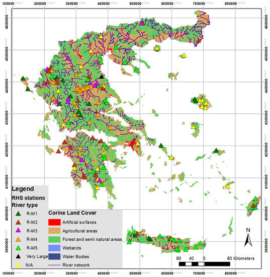
Figure 1.
Map showing the location of the sampling sites where the River Habitat Survey (RHS) method was applied. The distribution among the intercalibration river types according to [18]. R-M1 refers to “small Mediterranean streams”, R-M2 to “medium Mediterranean streams”, R-M3 to “large Mediterranean streams, R-M4 to “Mediterranean mountain streams” and R-M5 to “temporary streams”. “Very Large rivers” refer to catchments >10,000 km2 and N/A refers to reaches that have not been classified yet to types.
Table 2.
Short descriptions of the sub-scores that are assessed based on specific modifications; a brief explanation of the score derivation is also given.
Table 3.
Habitat Modification Classes and their description.
Environmental characteristics for the sampling sites, such as elevation, slope, distance from source and upstream catchment area, were obtained from the National Monitoring database of the HCMR. In addition, the shares of agricultural, artificial and natural land use within the catchment for each sampling site were calculated based on the available CORINE (Coordination of Information on the Environment) 2012 maps.
2.2. Data Analysis
Our data analysis comprises two discrete approaches. First, we investigated significant correlations between the total HMS, the sub-scores, the environmental characteristics and the land-uses by estimating the Pearson r coefficient with the purpose of highlighting strong relationships that could be worth further exploration. Second a principal component analysis (PCA) was conducted with the habitat modification sub-scores to identify the modification variables that explain most of the data variation and to explore gradients of key hydromorphological alterations. Correlation analysis was conducted with the "corrplot” package [19] and PCA with the “FactoMineR” package [20] in the R environment [21].
3. Results and Discussion
3.1. Hydromorphological Status
Figure 2 shows the distribution of the examined sites among the five classes of hydromorphological modification. The majority of the sites were characterized as significantly modified (N=32), while an additional 14 sites were severely modified in terms of hydromorphological alterations. Conversely, only 16 sites achieved an HMS between 0 and 16, thus falling into the pristine and semi-natural class of hydromorphological modification. Figure 3 illustrates examples of severely and significantly modified reaches. An important conclusion derived by these observations is that at least 70% of the studied sites presented severe hydromorphological modifications, which is in line with the general trend recorded for all of Europe. Τhe latest report from the European Environment Agency (EEA) [22] reported that 60% of all surface water bodies did not achieve good ecological status, while at the same time it listed hydromorphology as the most common pressure affecting almost 40% of all surface water bodies. Undoubtedly, our findings highlight the key role of hydromorphology in defining the ecological status of rivers.
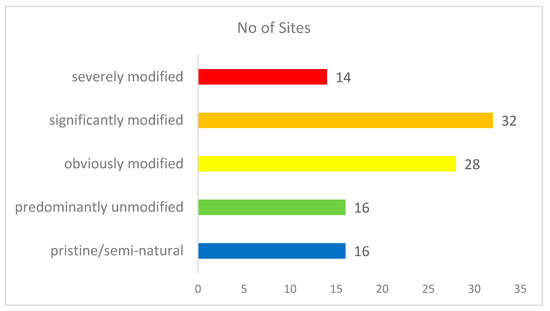
Figure 2.
Number of sites per class of hydromorphological modification.
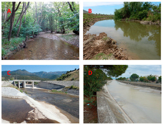
Figure 3.
The photos show watercourses with various degrees of hydromorphological modification. (A) A watercourse with absence of modifications rated as predominantly unmodified. (B) A significantly modified river reach. Left bank is characterized by resectioning and poaching. (C) This reach is classified as severely modified due to the presence of a large bridge, reinforcement of banks and channel and resectioning. (D) An example of channelized river with concrete (both banks and channel bed).
We also explored correlations between HMS and environmental descriptors of the river sites such as the elevation, the upstream catchment area, the distance from source and the shares of agriculture and natural land uses in the catchment (Table 4). We did not find any significant relationships between HMS and elevation, slope or catchment area, which can be interpreted as a lack of connection between river typology and hydromorphological modification. All river types presented similar variability in their hydromorphological status. Interestingly, the results showed weak relationships between the HMS and the proportional land uses in the upstream catchment (natural, artificial and agricultural). Specifically, HMS correlated positively (p < 0.05) with agriculture in the catchment and negatively with natural land uses (p < 0.05). This simply means that higher hydromorphological modification scores were recorded for streams that were located in catchments with higher agricultural activity or less natural land cover. Although this finding does not prove a cause–effect relationship between agriculture and hydromorphological degradation, it provides an indication that should be further explored in upcoming studies. It is not unlikely that intensive agricultural activities in the catchment are linked with farming and irrigation practices that alter the hydromorphology of rivers, as agriculture is considered the main driver of hydromorphological alteration in Europe [13].
Table 4.
Pearson correlations between Habitat Modification Score and environmental descriptors of the studied reaches. ** means that correlation is significant at the 0.01 level and * that correlation is significant at the 0.05 level. LUs refer to types of land uses according to the CORINE land cover inventory.
3.2. Main Components of Hydromorphological Modification
A correlation analysis and a principal component analysis (PCA) for the HMS and the sub-scores were employed to identify the modifications that contributed the most to the total HMS and explained the variance in our dataset. Our results showed that the banks and bed resectioning sub-score (mentioned as RS hereafter) had the highest correlation with the HMS followed by the channel realignment (RA), bank and channel reinforcement (RI) and the presence of dams and weirs (Figure 4). RS in particular presented a strong, linear relationship with HMS (R = 0.93) (Figure 5), which in practice shows that this kind of river alteration defines the total hydromorphological modification in the examined reaches.
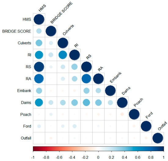
Figure 4.
Correlogram showing the correlations between the Habitat Modification Score and sub-scores. Positive correlations are displayed in blue and negative correlations in red. Color intensity is proportional to the correlation coefficient.
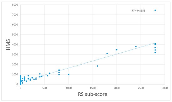
Figure 5.
Linear relationship between Habitat Modification Score and resectioning (RS) sub-score.
Concerning the results of the PCA, the first two components of the PCA accounted for a relatively low share of the total variance (28.7%), which indicated that the individual sub-scores were mostly uncorrelated. Still, using the PCA as an exploratory tool we examined the contribution of the HMS sub-scores to each component, and we identified that the presence of banks and bed resectioning, channel realignment and bridges had the largest contributions to the first principal component (PC1) (Figure 6 and Figure 7), which partly agree with the results of the correlation analysis. In contrast, the presence of bridges and fords had the largest contribution to the second principal component (PC2). These results may indicate a gradient of cross-sectional modifications across the reach along the PC1 where resectioning coincides with channel realignment. Similarly, PC2 may suggest a gradient of cross-sectional modifications at local points highlighted by the presence of bridges and fords and the reinforcement of banks and the channel bed that usually occurs with the construction of artificial in-channel features. As a main conclusion, the prevailing modifications in the studied reaches were the RS and the RA, which usually occurred together (high correlation between RS and RA, Figure 4), which also indicated the dominance of longitudinal modifications across the river reach. Conversely, modifications that occurred as artificial constructs in the form of bridges, weirs, dams and fords, appeared to play a lesser role in the total hydromorphological modification.
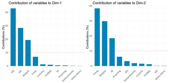
Figure 6.
Bars show the % contribution of each HMS sub-score to components 1 and 2 of the Principal Component Analysis (PCA). The red dashed line in each graph indicates the expected average contribution. RI means Bank Reinforcement, RS means Banks and Bed Resectioning and RA means Banks and Bed Realignment.
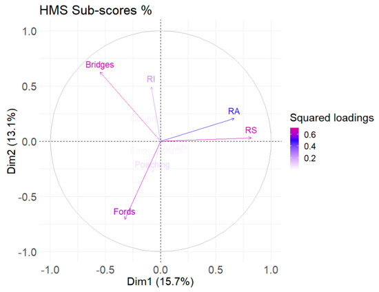
Figure 7.
PCA factor map of the HMS sub-scores. Arrows represent the squared loadings of the variables. Color intensity is proportional to the value of the loading. Variables that are closer to the correlation circle contribute more to the principal components. RI means Bank Reinforcement, RS means Banks and Bed Resectioning and RA means Banks and Bed Realignment.
These results agree with other previously published studies that have highlighted bank resectioning and reinforcement as main sources of hydromorphological alteration in 79 river sites from five different EU countries [23]. Bank resectioning is usually associated with channel realignment [5] and is used for producing more uniform channel forms that facilitate flood flows. Thus, bank and channel resectioning involves modifications that are part of flood defense management practices that usually protect neighboring agricultural land from flood events. On the other hand, bank reinforcement includes modifications that protect banks from erosion, using hard materials (concrete, bricks, rip-rap, etc.) as artificial substrate for banks and bed. Here we showed that bank reinforcement is associated with the presence of bridges; thus, we assume that reinforcement of both banks and bed occurs because of the construction of bridge structures and components (foundations, piers, abutments, etc.).
By further examining the PCA biplot (Figure 8), we can distinguish the most impaired sites (Group 5: severely modified) grouped along the vectors of RS and RA, while the sites that are significantly modified (Group 4) are mostly located between the vectors of RI and RA. Obviously modified sites (Group 3) showed a preference for the vector of Bridges HMS sub-score. These observations imply that bank and bed resectioning and realignment are closely related with the severe modifications, while at moderately impaired river reaches bridges appear to be the dominant cause for hydromorphological alteration.
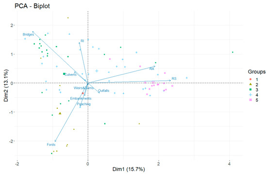
Figure 8.
PCA biplot showing the examined river reaches grouped based on their HMS score and the loadings of the shares of the HMS sub-scores to the total HMS. Groups (1–5) correspond to HMS Classes, where 1 = pristine/semi-natural, 2 = predominantly unmodified, 3 = obviously modified, 4 = significantly modified and 5 = severely modified.
3.3. Recommendations for Mitigation of Hydromorphological Alteration and Restoration of Degraded Rivers
The hydromorphology of rivers in Europe has been impacted for many decades by river engineering practices that usually aim to reduce the flood risk for the adjacent urban areas and agricultures [24]. Such practices involve the change of the planform and the physical geometry of the channel leading to a simplification of river networks (e.g., loss of meanders and floodplains) [25]. Resectioning and realignment can be described as anthropogenic interventions that are part of an overall channelization process that transforms natural complex channels to simple forms (uniform channels) by widening, deepening and straightening the channel [25,26]. With this study we identified the channel resectioning and realignment as the main components of the overall hydromorphological modification in the examined river reaches, which suggests that channelization is a major problem in rivers of Greece. As channel complexity is known to promote biodiversity and ecosystem functioning in riverine systems [27], it is obvious that any anthropogenic change that causes loss of physical and morphological complexity may result in ecological degradation. In addition, we recognized the presence of bridges and other transversal structures (e.g., fords and weirs) as important features of the overall hydromorphological alteration, but to a lesser extent. However due to the limited dataset, compared to the whole extent of the national monitoring program, and the fact that a significant share of the monitoring sites is located close to bridges for easier accessibility, we consider it very possible that bridges actually play an even smaller role in the determination of the hydromorphological status. Moreover, the majority of the examined monitored sites were not close to significant dams or other large-scale abstraction schemes; therefore, the associated ecological impacts close to such hydrological pressures may not be adequately recorded yet. As the WFD monitoring process evolves, a more complete picture about the hydromorphological pressures and impacts in the Greek rivers will be captured.
Nevertheless, what is clear is that restoration projects should include measures that aim to re-establish the natural character of the degraded reach by recreating physical habitats, such as pool-rifles sequences, and practically restore the natural planform by remeandering and widening the floodplain [28,29,30]. There are examples that have shown in practice a significant improvement in habitat diversity by applying restoration measures such as floodplain widening [31]. At the same time, nature-based solutions can be used to ensure adequate measures to minimize the risk of flooding [32]. With this regard, modelling studies can be used to simulate the effects of nature-based restoration techniques in order to ascertain and even optimize their application before their actual implementation [32,33].
However, perhaps the most important implication for an effective management and restoration scheme is that measures that aim to improve the river hydromorphology require also actions at local reach scale and not only general and abstract schemes of measures that are implemented at catchment scale (e.g., land conversion). This study showed that modifications at small spatial scale (e.g., site-specific artificial structures, fords, bridges) play a small but significant role in determining the hydromorphological status of watercourses. Furthermore, severe modifications, such as river resectioning and realignment, may concern larger river segments but may appear also locally (few hundred meters). Field surveys such as the RHS can locate small-scale hydromorphological alterations and aid water managers to formulate additional measures or adjust the current ones in order to meet the requirements of the WFD.
4. Conclusions
This work presents the first results from a nationwide assessment of the hydromorphological status of Greek rivers in line with the WFD that will set the foundations for exploring the relationships between river hydromorphology, habitat diversity and ecological responses in Greek rivers.
In summary, our findings highlighted channel resectioning, realignment and reinforcement as the main features of hydromorphological alteration, followed by the presence of bridges and fords. We assume that bank reprofiling and channel straightening, which are common flood protection measures for mitigating flood risk in agricultural catchments, are the main cause of longitudinal cross sectional hydromorphological changes in Greek rivers. Conversely, bridges, fords and associated artificial structures and reinforcements in banks and channels are the most common cause for site-specific cross-sectional changes and appear to play a lesser role in the overall hydromorphological modification. This could possibly mean that hydromorphological assessments can focus on changes that concern the overall shape of the watercourse and disregard extensive and laborious field recordings of local artificial structures (e.g., small bridges, fords, weirs, deflectors, etc.). In this regard, novel hydromorphological assessments may take advantage of technological advancements such as unmanned aerial vehicles (UAVs) that allow for a rapid assessment of major hydromorphological features such as types of substrates, riparian cover, planform, riverine habitats and others [34,35].
Thus, it is feasible and relatively easy to identify modifications that occur at larger spatial scale such as realignment and resectioning of river reaches.
Furthermore, river typology plays a crucial role in identifying patterns of alterations and distinguishing the main hydromorphological features [35]. Although our analysis is based on an extended dataset covering 106 river reaches from all over Greece, additional observations and measurements will allow us to produce more robust results. Nevertheless, the presented findings can provide valuable information regarding the extent of the total hydromorphological change and its main components that may potentially aid water managers to formulate more effective management plans and restoration measures.
Author Contributions
Conceptualization, K.S.; methodology, K.S., A.L. (Anna Latsiou) and E.D.; data curation, K.S., A.L. (Anna Latsiou), T.K., K.G., A.L. (Anastasia Lampou), N.K. and E.D., formal analysis, K.S., A.L. (Anna Latsiou) and E.D; visualization, K.S. and E.D.; writing—original draft, K.S.; writing—review and editing, K.S., A.L. (Anna Latsiou), T.K., N.K., K.G., A.L. (Anastasia Lampou) and E.D. All authors have read and agreed to the published version of the manuscript.
Funding
This research received no external funding.
Conflicts of Interest
The authors declare no conflicts of interest.
References
- González del Tánago, M.; Gurnell, A.M.; Belletti, B.; García de Jalón, D. Indicators of river system hydromorphological character and dynamics: Understanding current conditions and guiding sustainable river management. Aquat. Sci. 2016, 78, 35–55. [Google Scholar] [CrossRef]
- Grizzetti, B.; Pistocchi, A.; Liquete, C.; Udias, A.; Bouraoui, F.; Van De Bund, W. Human pressures and ecological status of European rivers. Sci. Rep. 2017, 1–11. [Google Scholar] [CrossRef]
- Belletti, B.; Nardi, L.; Rinaldi, M.; Poppe, M.; Brabec, K.; Bussettini, M.; Comiti, F.; Gielczewski, M.; Golfieri, B.; Hellsten, S.; et al. Assessing Restoration effects on river hydromorphology using the process-based morphological quality index in eight European river reaches. Environ. Manag. 2018, 61, 69–84. [Google Scholar] [CrossRef]
- Belletti, B.; Rinaldi, M.; Buijse, A.D.; Gurnell, A.M.; Mosselman, E. A review of assessment methods for river hydromorphology. Environ. Earth Sci. 2014, 73, 2079–2100. [Google Scholar] [CrossRef]
- Raven, P.J.; Holmes, N.T.H.; Dawson, F.H.; Everard, M. Quality assessment using River Habitat Survey data. Aquat. Conserv. Mar. Freshw. Ecosyst. 1998, 8, 405–424. [Google Scholar] [CrossRef]
- Kamp, U.; Binder, W.; Hölzl, K. River habitat monitoring and assessment in Germany. Environ. Monit. Assess. 2007, 127, 209–226. [Google Scholar] [CrossRef]
- Ollero, A.; Ibisate, A.; Gonzalo, L.E.; Acín, V.; Ballarín, D.; Díaz, E.; Domenech, S.; Gimeno, M.; Granado, D.; Horacio, J.; et al. The IHG index for hydromorphological quality assessment of rivers and streams: Updated version. Limnetica 2011, 30, 255–262. [Google Scholar]
- Rinaldi, M.; Surian, N.; Comiti, F.; Bussettini, M. A method for the assessment and analysis of the hydromorphological condition of Italian streams: The Morphological Quality Index (MQI). Geomorphology 2013, 180–181, 96–108. [Google Scholar] [CrossRef]
- Rinaldi, M.; Belletti, B.; Bussettini, M.; Comiti, F.; Golfieri, B.; Lastoria, B.; Marchese, E.; Nardi, L.; Surian, N. New tools for the hydromorphological assessment and monitoring of European streams. J. Environ. Manag. 2017, 202, 363–378. [Google Scholar] [CrossRef]
- Bechter, T.; Baumann, K.; Birk, S.; Bolik, F.; Graf, W.; Pletterbauer, F. LaRiMo—A simple and efficient GIS-based approach for large-scale morphological assessment of large European rivers. Sci. Total Environ. 2018, 628–629, 1191–1199. [Google Scholar] [CrossRef]
- Knehtl, M.; Petkovska, V.; Urbanič, G. Is it time to eliminate field surveys from hydromorphological assessments of rivers?—Comparison between a field survey and a remote sensing approach. Ecohydrology 2018, 11, 1–12. [Google Scholar] [CrossRef]
- Boon, P.J.; Holmes, N.T.H.; Raven, P.J. Developing standard approaches for recording and assessing river hydromorphology: The role of the European Committee for Standardization (CEN). Aquat. Conserv. Mar. Freshw. Ecosyst. 2010, 20, 55–61. [Google Scholar] [CrossRef]
- Fehér, J.; Gáspár, J.; Szurdiné-Veres, K.; Kiss, A.; Kristensen, P.; Peterlin, M.; Globevnik, L.; Kirn, T.; Semerádová, S.; Künitzer, A.; et al. Hydromorphological Alterations and Pressures in European Rivers, Lakes, Transitional and Coastal Waters; Thematic assessment for EEA Water 2012 Report. ETC/ICM Technical Report 2/2012; European Topic Centre on Inland, Coastal and Marine Waters: Prague, Czech Republic, 2012. [Google Scholar]
- Davy-Bowker, J.; Furse, M.T. Hydromorphology—Major results and conclusions from the STAR project. Hydrobiologia 2006, 566, 263–265. [Google Scholar] [CrossRef]
- Stefanidis, K.; Papaioannou, G.; Markogianni, V.; Dimitriou, E. Water quality and hydromorphological variability in Greek rivers: A nationwide assessment with implications for management. Water 2019, 11, 1680. [Google Scholar] [CrossRef]
- Naura, M.; Clark, M.J.; Sear, D.A.; Atkinson, P.M.; Hornby, D.D.; Kemp, P.; England, J.; Peirson, G.; Bromley, C.; Carter, M.G. Mapping habitat indices across river networks using spatial statistical modelling of River Habitat Survey data. Ecol. Indic. 2016, 66, 20–29. [Google Scholar] [CrossRef]
- Fox, P.J.A.; Naura, M.; Scarlett, P. An account of the derivation and testing of a standard field method: An example using River Habitat Survey. Aquat. Conserv. Mar. Freshw. Ecosyst. 1998, 8, 455–475. [Google Scholar] [CrossRef]
- Lazaridou, M.; Ntislidou, C.; Karaouzas, I.; Skoulikidis, N. Harmonisation of a new assessment method for estimating the ecological quality status of Greek running waters. Ecol. Ind. 2017, 84, 683–694. [Google Scholar] [CrossRef]
- Wei, T.; Simko, V. R package “corrplot”: Visualization of a Correlation Matrix. Available online: https://github.com/taiyun/corrplot (accessed on 1 March 2020).
- Lê, S.; Josse, J.; Husson, F. FactoMineR: A package for multivariate analysis. J. Stat. Softw. 2008, 25, 1–18. [Google Scholar] [CrossRef]
- R Core Team. R: A Language and Environment for Statistical Computing; R Foundation for Statistical Computing: Vienna, Austria, 2018. [Google Scholar]
- European Environment Agency [EEA]. European Waters—Assessment of Status and Pressures; EEA Report No 7/2018; EEA: Copenhagen, Denmark, 2018. [Google Scholar]
- Erba, S.; Buffagni, A.; Holmes, N.; O’Hare, M.; Scarlett, P.; Stenico, A. Preliminary testing of River Habitat Survey features for the aims of the WFD hydromorphological assessment: An overview from the STAR Project. Hydrobiologia 2006, 566, 281–296. [Google Scholar] [CrossRef]
- Feld, C.K.; Birk, S.; Bradley, D.C.; Hering, D.; Kail, J.; Marzin, A.; Melcher, A.; Nemitz, D.; Pedersen, M.L.; Pletterbauer, F.; et al. From Natural to Degraded Rivers and Back Again: A Test of Restoration Ecology Theory and Practice. In Advances in Ecological Research, 1st ed.; Woodward, G., Ed.; Elsevier Ltd.: Amsterdam, The Netherlands, 2011; Volume 44, pp. 119–209. [Google Scholar] [CrossRef]
- Anim, D.O.; Fletcher, T.D.; Vietz, G.J.; Pasternack, G.B.; Burns, M.J. Effect of urbanization on stream hydraulics. River Res. Appl. 2018, 34, 661–674. [Google Scholar] [CrossRef]
- Florsheim, J.L.; Pellerin, B.A.; Oh, N.H.; Ohara, N.; Bachand, P.A.M.; Bachand, S.M.; Bergamaschi, B.A.; Hernes, P.J.; Kavvas, M.L. From deposition to erosion: Spatial and temporal variability of sediment sources, storage, and transport in a small agricultural watershed. Geomorphology 2011, 132, 272–286. [Google Scholar] [CrossRef]
- Elosegi, A.; Díez, J.; Mutz, M. Effects of hydromorphological integrity on biodiversity and functioning of river ecosystems. Hydrobiologia 2010, 657, 199–215. [Google Scholar] [CrossRef]
- Gurnell, A.; Bussettini, M.; Camenen, B.; Gonzalez Del Tanago, M.; Grabowski, R.; Hendriks, D.; Henshaw, A.; Latapie, A.; Rinaldi, M.; Surian, N. A Hierarchical Multi-Scale Framework and Indicators of Hydromorpho—Logical Processes and Forms; Report D2.1. Part 1 of the FP7 project REFORM. 2014. Available online: http://www.reformrivers.eu/multi-scale-framework-and-indicators-hydromorphological-processes-and-forms-i-main-report (accessed on 1 March 2020).
- Muhar, S.; Januschke, K.; Kail, J.; Poppe, M.; Schmutz, S.; Hering, D.; Buijse, A.D. Evaluating good-practice cases for river restoration across Europe: Context, methodological framework, selected results and recommendations. Hydrobiologia 2016, 769, 3–19. [Google Scholar] [CrossRef]
- Dyste, J.M.; Valett, H.M. Assessing stream channel restoration: The phased recovery framework. Restor. Ecol. 2019, 27, 850–861. [Google Scholar] [CrossRef]
- Poppe, M.; Kail, J.; Aroviita, J.; Stelmaszczyk, M.; Giełczewski, M.; Muhar, S. Assessing restoration effects on hydromorphology in European mid-sized rivers by key hydromorphological parameters. Hydrobiologia 2016, 769, 21–40. [Google Scholar] [CrossRef]
- Ourloglou, O.; Stefanidis, K.; Dimitriou, E. Assessing nature-based and classical engineering solutions for flood-risk reduction in urban streams. J. Ecol. Eng. 2020, 21, 46–56. [Google Scholar] [CrossRef]
- Theodoropoulos, C.; Stamou, A.; Vardakas, L.; Papadaki, C.; Dimitriou, E.; Skoulikidis, N.; Kalogianni, E. River restoration is prone to failure unless pre-optimized with a mechanistic ecological framework |Insights from a model-based case study. Water Res. 2020, 173, 11550. [Google Scholar] [CrossRef]
- Dimitriou, E.; Stavroulaki, E. Assessment of riverine morphology and habitat regime using unmanned aerial vehicles in a Mediterranean environment. Pure Appl. Geophys. 2018, 175, 3247–3261. [Google Scholar] [CrossRef]
- Szoszkiewicz, K.; Buffagni, A.; Davy-Bowker, J.; Lesny, J.; Chojnicki, B.H.; Zbierska, J.; Staniszewski, R.; Zgola, T. Occurrence and variability of River Habitat Survey features across Europe and the consequences for data collection and evaluation. Hydrobiologia 2006, 566, 267–280. [Google Scholar] [CrossRef]
© 2020 by the authors. Licensee MDPI, Basel, Switzerland. This article is an open access article distributed under the terms and conditions of the Creative Commons Attribution (CC BY) license (http://creativecommons.org/licenses/by/4.0/).