Article

Land Use and Land Cover Changes under Climate Uncertainty: Modelling the Impacts on Hydropower Production in Western Africa

1
Faculty of Science and Techniques, Master Research Program of the West African Science Service Center on Climate Change and Adapted Land Use (WASCAL), Climate Change and Energy, University abdou Moumouni of Niamey, P.O. Box 10662, Niamey 8000, Niger
2
Department of Energy and Environmental Engineering, University of Energy and Natural Resources, P.O. Box 214, Sunyani, Ghana
*
Author to whom correspondence should be addressed.
Hydrology 2017, 4(1), 2; https://doi.org/10.3390/hydrology4010002
Submission received: 31 October 2016 / Revised: 8 December 2016 / Accepted: 27 December 2016 / Published: 5 January 2017

Abstract

:
The Bui hydropower plant plays a vital role in the socio-economic development of Ghana. This paper attempt to explore the combined effects of climate-land use land cover change on power production using the (WEAP) model: Water Evaluation and Planning system. The historical analysis of rainfall and stream flow variability showed that the annual coefficient of variation of rainfall and stream flow are, respectively, 8.6% and 60.85%. The stream flow varied greatly than the rainfall, due to land use land cover changes (LULC). In fact, the LULC analysis revealed important changes in vegetative areas and water bodies. The WEAP model evaluation showed that combined effects of LULC and climate change reduce water availability for all of demand sectors, including hydropower generation at the Bui hydropower plant. However, it was projected that Bui power production will increase by 40.7% and 24.93%, respectively, under wet and adaptation conditions, and decrease by 46% and 2.5%, respectively, under dry and current conditions. The wet condition is defined as an increase in rainfall by 14%, the dry condition as the decrease in rainfall by 15%; current account is business as usual, and the adaptation is as the efficient use of water for the period 2012–2040.

1. Introduction

The world’s environmental challenge today is climate change. Climate change is predicted to have major impacts on many aspects of human society, from agriculture and energy production to water supply [1]. Hydropower has a significant role to play in the era of Climate Change where Green Energy is the key to reducing global warming [2]. However, hydropower production may face challenges due to dependence on water availability and rainfall variability. According to [1,3], freshwater related-risks to climate change increase significantly with greenhouse gas emissions. Climate change is projected to reduce renewable surface water and groundwater resources significantly in most dry sub-tropical regions and will exacerbate competition for water among agriculture, ecosystems settlement, industry, energy, and food security. In addition to climate change, the stream flow regimes and runoff are key elements to be conserved in the planning and water management of the basin.
LULC can lead to changes in the infiltration capacity of the land, therefore, changing the dynamic of the runoff. The increase in population with increase in land use for agricultural, urbanization lead to direct impacts on runoff and stream flow [4]. Land cover plays an important role in the ecosystem, its change can lead to the modification of the micro-climate, and therefore, the hydrological cycle of that basin. (Andreini et al., 2002) [5] focused on the rainfall-runoff relationship over the Volta basin before and after the construction of the Akosombo dam. Their results showed that the coefficient of variation of runoff from the sub-watersheds is much more variable than rainfall, due to land use. According to the same study, it is apparent from the Volta water balance that land use and land cover changes in the uplands of the basin play a pivotal role in determining the future of the basin water resources. (Wei et al., 2013) [6] argued that the relative hydrological effects of forest changes and climatic variability are largely dependent on the change magnitudes and watershed characteristics. In some extents, impacts on the watershed of forest changes or land use changes can be as important as those from climatic variability. A key variable that can affect runoff generation could be land cover change [7]. Climate and land use change already have a large impact on the hydrological cycle in West African countries [8,9,10]. These changes can have direct or indirect impacts on the hydrological cycle of the watershed. According to [7], there is inter-annual variability in rainfall and runoff and the mean monthly potential evapotranspiration over the Black Volta.
The expansion of forest (afforestation) can result in reduction in the stream flow while the deforestation can lead to an increase in the stream flow at the small scale [11,12]. However, the afforestation-deforestation effects may be different in a larger-scale basin [4]. For instance, study in an upland watershed in Sri Lanka, showed that replacement of natural forests by other agricultural land uses led to decreased base flows and increased surface runoff generation, while the annual water yield remained more or less unchanged [4]. Change in land cover can affect the microclimate of the given area [13] and the infiltration rates can be reduced on cultivated land compared to natural land cover [10,14].
Hydropower production can be seriously reduced during extreme events. According to [15], in Kenya, a drought over the period 1998–2000 reduced hydropower production, while in Ghana in 1998 shortages in rainfall caused hydropower production to fall by up to 40%. Moreover, in both 2006 and 2011, Tanzania, experienced energy crises due to droughts. These examples give an insight on how climate variability and uncontrolled land use can impact hydropower potential. The objectives of the present work are: (i) to access the historical steam flow and rainfall variability; (ii) to access land use land cover change; and (iii) to evaluate the potential effect of the LULC and climate change on the Bui hydropower production via the WEAP model. The expected results of this study are to improve water management in the Black Volta basin.

2. Materials and Methods

2.1. Study Area Presentation

Black Volta is located in West Africa at latitude 7 N–15 N and longitude 5.5 W–1.5 W. It is a trans-boundary basin shared between Ghana, Ivory Coast, Burkina Faso, and Mali, and covers an area of 156,798 km2 (see Figure 1). It is one of the sub-basins of the Volta basin. The basin is mainly located in the north western part of Ghana and the south western part of Burkina Faso. The basin includes northern and central parts of Ghana, Southern Burkina Faso, Southern Mali, and Northern Cote d’Ivoire.
The climate of the Black Volta, like the whole of West Africa’s climate, is controlled by the movement of the Inter Tropical Convergence Zone (ITCZ). The southern part of the Black Volta presents a bimodal rainfall pattern (March–June and August–November). The Black Volta’s annual rainfall varies between 1400 mm and 1000 mm and varies from south to north [16]. The pan evaporation is estimated at 2540 mm per year, and an average annual runoff coefficient of about 8.3% [17]. The mean monthly runoff from the sub-basin varies on average from about 623 m3/s at the peak of the rainy season to about 2 m3/s in the dry season [9]. During the rainy season, the rainfall is greater than evapotranspiration, and vice versa, during the dry seasons. The basin’s mean, highest and lowest temperature are, respectively, 26 °C, 44 °C and 15 °C. The relative humidity varies between 20%–30% during the harmattan season and 70%–80% in the rainy season.
The Bui hydropower station is on the border of the Northern Region and the Brong-Ahafo Region in Ghana. The Bui hydropower plant comprises three Francis-type turbines with an installed capacity of 3× 133 MW, producing about 400 MW, the second largest of Ghana’s hydropower plant. The construction of this dam holds a total capacity of 12,570,000,000 m3 and an active capacity of 7,720,000,000 m3 is for multipurpose use: energy production and irrigation. The reservoir’s maximum operating level is 185 m above sea level (a.s.l.) and the minimum is 167 m a.s.l.

2.2. Land Use and Land Cover Change Analysis

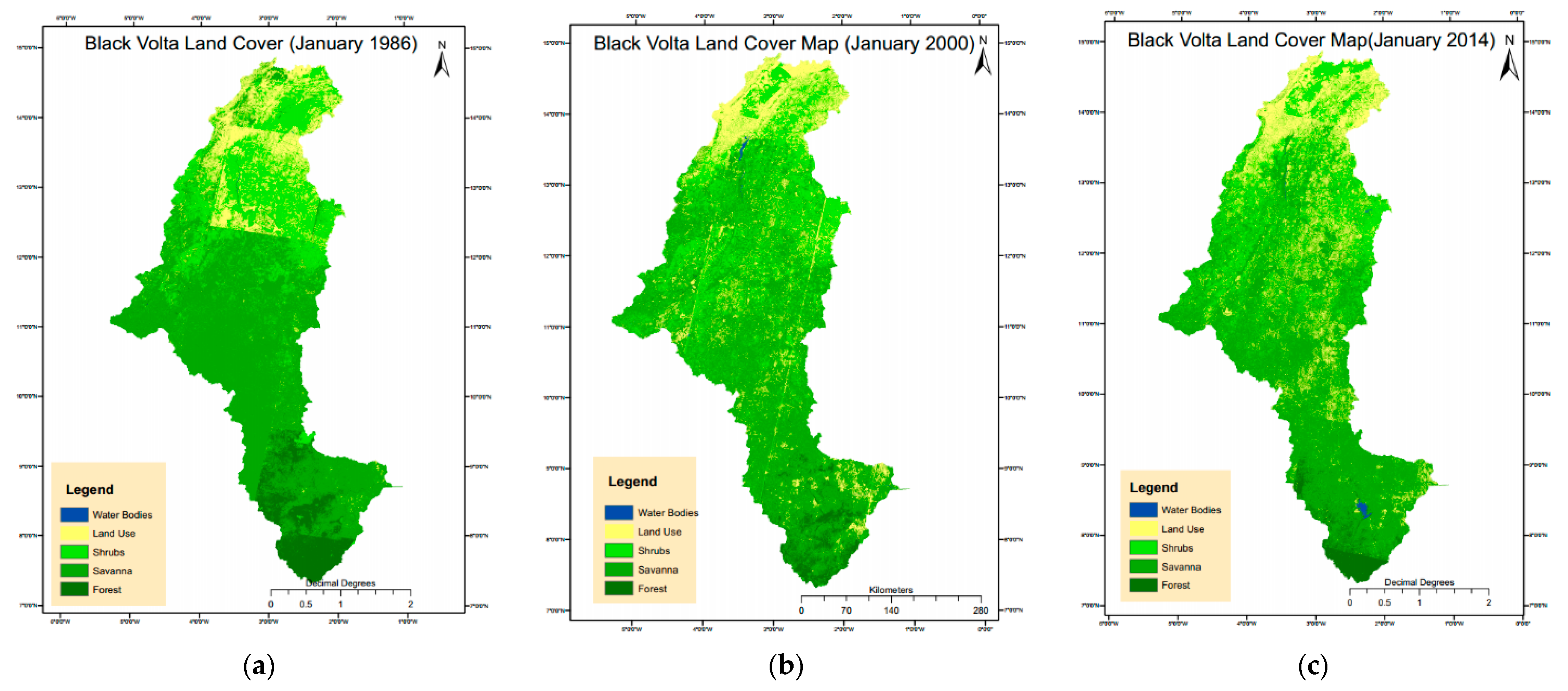
The canopy of vegetation may vary significantly between the south and the north parts of the Black Volta due to the differences in rainy season within the climatic zones in the basin. The months of January and February are the driest for all climatic zones and across the whole basin. These months also present less cloud cover, therefore, enhancing the quality of satellite images. Therefore, the Landsat 5, 7, and 8 data were obtained for the years 1986, 2000, and 2014, respectively, for the months of January and February. The land cover was classified in five groups, namely, water bodies, land use, shrubs, savanna and forest. The water bodies represent the stream line, small reservoirs, and dams and the land use referring to agricultural land, urban area, and bare land. The shrubs represent some woody plants, smaller than a tree, usually having multiple permanent stems branching from or near, the ground or woody plants of relatively low height, having several stems arising from the base and lacking a single trunk. The savanna represents grassland with scattered trees, grading into either open plain or woodland while the forest is referred to growth of trees and other plants covering a large area. In order to calibrate and validate the land cover classification the accuracy assessment was performed and the kappa coefficient was used as the statistical parameter.

2.3. Rainfall and Stream Flow Analysis

The rainfall data obtained from thirteen meteorological stations within Ghana (five stations) and Burkina Faso (eight stations) were considered in this study. The Thiessen method was applied to compute the mean rainfall. This mean rainfall amount was then converted into cubic meters per second (cms) in order to facilitate its comparison with the stream flow. Further analyses were performed in terms of annual and seasonal variation of the rainfall and stream flow. In addition, annual rainfall was aggregated in very dry, dry, normal, wet, and very wet years based on P-factor analysis.
The P-factor is the percentage at which the rainfall depth is lower or higher than the normal year. A year is called normal if its mean rainfall depth is equal, or closer, to the mean annual rainfall of the period of study and it has the value of 1. The P-Factor is given as:
P-factor = 1 ± value 100
For example, if the dry years have 5% of mean rainfall depth less than the normal year, then it has the P-factor equal to 0.95 and if the very wet year has 9% of mean annual rainfall depth than the normal year, then it has the P-factor equal to 1.09. In fact, the value is defined as:
  • (Mean − standard deviation) × 100/Mean corresponding to very dry year,
  • (Mean − 0.5 × standard deviation) × 100/Mean corresponding to dry year,
  • (Mean + 0.5 × standard deviation) × 100/Mean corresponding to wet year and
  • (Mean + standard deviation) × 100/Mean corresponding to very wet year.

2.4. Brief Description of the Black Volta WEAP Model Implementation

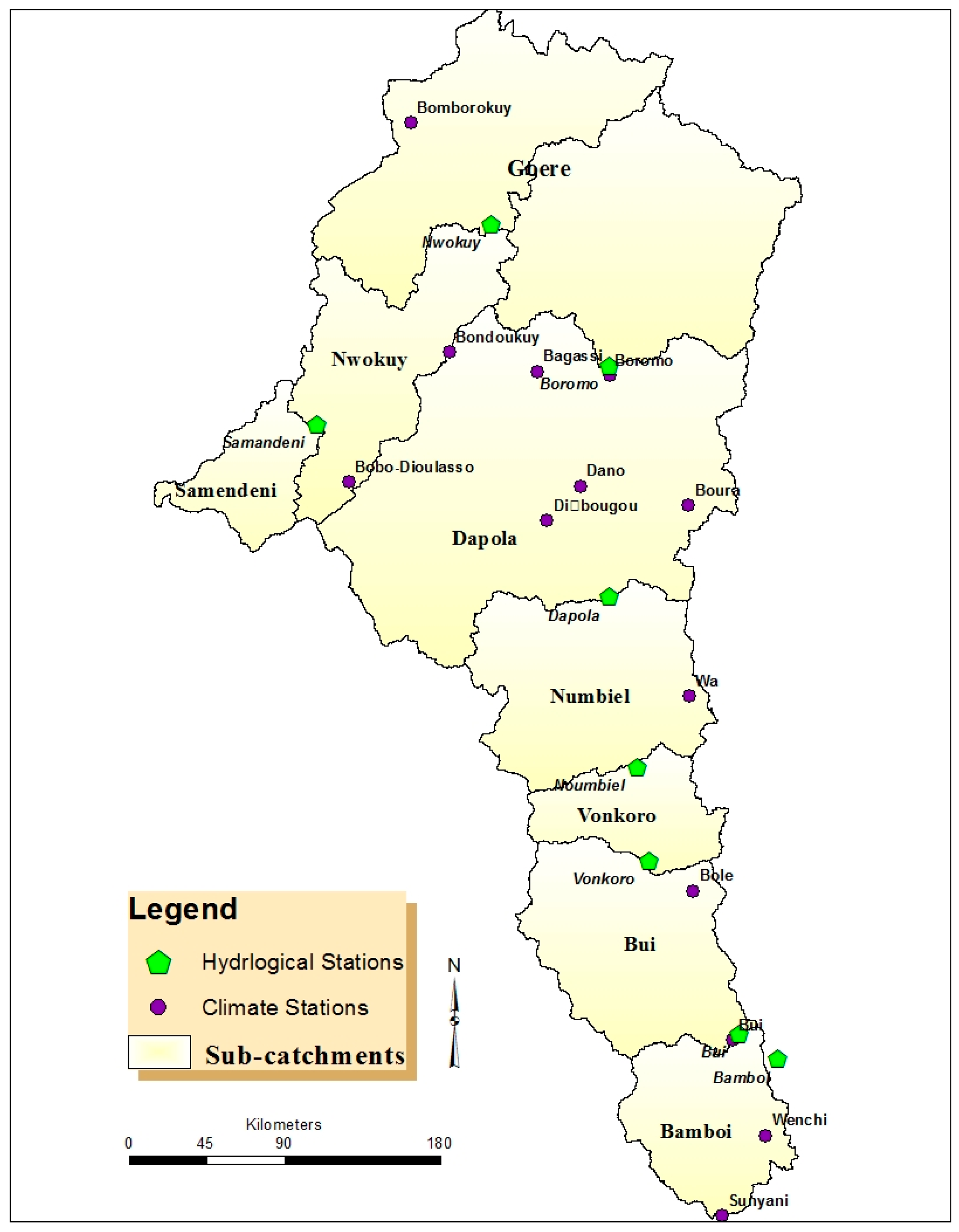
The starting point of the model implementation was the watershed, river network and sub-catchment delineation. The water demand per sector and per sub-catchment were included considering the following water demand side sectors: domestic, livestock, irrigation, small Reservoir, and hydropower. The Bui reservoir was included in the Bui sub-catchment (see Figure 2). In WEAP, catchment processes such as evapotranspiration, runoff, infiltration, and irrigation demands, can be simulated based on four methods including: (a) the rainfall runoff method; (b) irrigation demand; (c) the soil moisture method; and (d) the MABIA method. The Soil Moisture Method was selected for the present work because of its specificities of including the characterization of Land Use and/soil types impacts on the catchment processes.
The land use classes were incorporated as a percentage share. Climate data including precipitation, temperature, relative humidity, cloud fraction, and wind speed have also been used.

2.5. The WEAP Model Evaluation

The model calibration and validation was performed to determine values of a set of key parameters which represent the physical characteristics of the catchments. These parameters include soil water capacity, root zone conductivity and runoff resistance factor. To explore how well the model reproduced river flows as observed at any given gauging station, the Nash-Sutcliffe coefficient (NS) and the coefficient of determination (R2) were computed. The model was calibrated and validated in two sub-catchments: Bui and Samandeni (Figure 2 shows the sub-catchment in Black Volta).
The Nash–Sutcliffe coefficient is defined by the Equation (2) and the coefficient of determination by Equation (3) as:
NS = 1 i = 1 n ( Q sim , i Q obs , i ) 2 i = 1 n ( Q obs , i Q ¯ obs ) 2
R 2 = i = 1 n ( Q obs , i Q ¯ obs ) ( Q sim , i Q ¯ sim ) [ i = 1 n ( Q obs , i Q ¯ obs ) 2 ] 0.5 [ i = 1 n ( Q sim , i Q ¯ sim ) 2 ] 0.5
where: Qobs,i is the observed flow at time i (m3/s), Q ¯ obs is the mean of observed flow (m3/s), Qsim.i is the simulated flow at time i (m3/s), and Q ¯ sim is the mean of simulated flow (m3/s). The greater the values of NS and R2, the better the model reproduced observations, with 1 being the ideal situation. The monthly data was used for the calibration and the validation. The periods 2000–2005 and 2000–2002 were used for calibration, while the periods 2006–2010 and 2003–2005 were used for validation, respectively, for the sub-catchment of Bui and Samandeni. The periods of calibration and validation were chosen according to data availability. Another reason for selecting these periods was the fact that our main focus was on the Bui dam, which was constructed between 2009–2012. This also explains our choice of the year 2000 as the starting year (current account/scenario year for the WEAP model).

2.6. Scenarios Development

2.6.1. Climate Change Scenarios

A compilation from the Intergovernmental Panel on Climate Change (IPCC) fourth report, 2007 (AR4) by the African Ministerial Conference on Environment (AMCEN) Secretariat suggests that average temperature will increase over the African continent by 1.5 °C to 3 °C by 2050 [18]. The IPCC global assessment of climate change, 2007 synthesis report noted that the West Africa region, within which lies the Black Volta basin, experienced a mean temperature rise which ranged from 0.2 °C to 1 °C between 1974 and 2004, increasing by at least 0.2 °C per decade [19]. Then, for this paper, we assumed that the rise in temperature is 1 °C for the projected period the same as in another study [20]. However, the simulation of large-scale patterns of precipitation has improved somewhat since the AR4, although models continue to perform less well for precipitation than for surface temperature [1]. Thus, the fifth assessment report of IPCC, 2014 (AR5) the observed temperature over West Africa was statistically significant and vary between 0.5 °C and 0.8 °C between 1970 and 2010 [21]. As for the precipitation over West Africa, the Sahel experienced a significant reduction overall, over the course of 20th century, with drought between 1970–1980 and with a recovery toward the last 20 years of the century [21].
This will be considered for all CC scenarios. Climate change scenarios are defined as:
Current condition or “as business as usual” scenario: in this scenario, there is no change in precipitation relative to historical trends.
Wetter scenario: This scenario assumes an increase in precipitation relative to historical trends. The average annual rainfall increases by 14.2%, and ranges from 7% to 20% during the 30-year simulation period from 2000 to 2040.
Drier scenario: This scenario assumes decrease in precipitation. The relative reduction in annual precipitation averaged 15.8%, ranging from 9% to nearly 21% over the simulation period.
Adaptation scenario: demand management programs will result in a reduction of the irrigation water usage by 20%, domestic loss reduces to 10% for rural and 2% for urban areas.

2.6.2. The WEAP Model Scenarios

The WEAP evaluation was based on five scenarios as follow:
Scenario 1. No LCC and No CC: no land use change and no climate change. This scenario inheriting from References business as usual.
Scenario 2. No LCC and CC: is based on the climate change condition.
Scenario 3. LCC and CC: it uses the projected LULC change and the climate change condition.
Scenario 4. LCC and No CC: uses the projected LULC change.
Scenario 5. Adaptation: under this scenario, water for irrigation is efficiently used and the rain water harvesting was put in place for domestic needs, while the demand management program will reduce the irrigation water by 20%, domestic water loss by 10% in rural areas and 2% for urban areas.

3. Results

3.1. Land Use Land Cover Change Analysis

Land classification can be subjected to error due to geometric errors, misclassifications, and undefined classes. To statistically quantify these errors, a random selection of pixels of the classified maps was performed to build a confusion matrix. The kappa coefficient K, a discrete multivariate technique used in accuracy assessments of thematic maps, is an efficient approach to derive information from an image via the confusion matrix [22,23,24,25]. K > 0.80 represents strong agreement and good accuracy, 0.40–0.80 is middle, and <0.40 is poor [26]. For this study, the kappa coefficient for the years 1986, 2000, and 2014 are respectively K1986 = 81.5%, K2000 = 89%, and K2014 = 84.5%, showing strong agreement. In general, the LULCC were correctly classified with strong agreement.
The results from the LULC trend analysis (Table 1) shows that water bodies have increased rapidly in the basin. This increase can be explained by the increase in the construction of small reservoirs and the Bui dam. The land use occupied about 16%, 18%, and 30% of the study area, respectively, in 1986, 2000 and 2014. This represents an increase of 12.7% between 1986 and 2000, 59.9% between 2000 and 2014. This relatively high percentage change can be linked to a high rate of urbanization, increases in bare land, and an extension of agricultural land (note that land use class as defined in this paper refers to the ensemble of agricultural land, urban area, and bare land). The excessive use of trees for timber, for charcoal, wood fires, and the phenomenon of uncontrolled bushfire are the main factors contributing to land cover change. In fact, the fire strips the land of its vegetative cover by burning trees and grasses; thus, pastures for livestock are largely destroyed. The soil is then exposed to erosion as it lies bare for most of the season and then leads to land cover change. In addition, bushfires are cited among the causes of soil erosion in the Volta basin [27], while the charcoal and wood fuel production are considered as threats to Africa’s forests [28].
The shrubs covered about 21.4%, 24.7%, and 22.6% in 1986, 2000, and 2014. There was an increase of about 15.6% between 1986 and 2000 and a decrease of about 8.9% between 2000 and 2014 in shrub cover. The period of the 1980s was considered as a drier period with less vegetation, while the year 2000 is considered as a normal year with high vegetation cover. The decrease in shrubs between the year 2000 and 2014 may be due to the expansion of agriculture (farmland and livestock breeding). The expansion of agriculture land also resulted in a decrease of savanna.
The forest occupied about 8.7%, 3.7%, and 3.8% of the study area, respectively, in 1986, 2000, and 2014. We noticed an important decrease of about 57% forest coverage between 1986 and 2000 many in the Ghana and Ivory Coast (see Figure 3a,b), and an increase about 4% between 2000 and 2014. The sharp decrease (1986–2000) can be explained by the excessive use of the forest for timber and agriculture. The small increase in forest cover during the 2000–2014 period may be due to some land conservation practices in the basin.

3.2. Rainfall-Stream Variability

3.2.1. Annual Variation

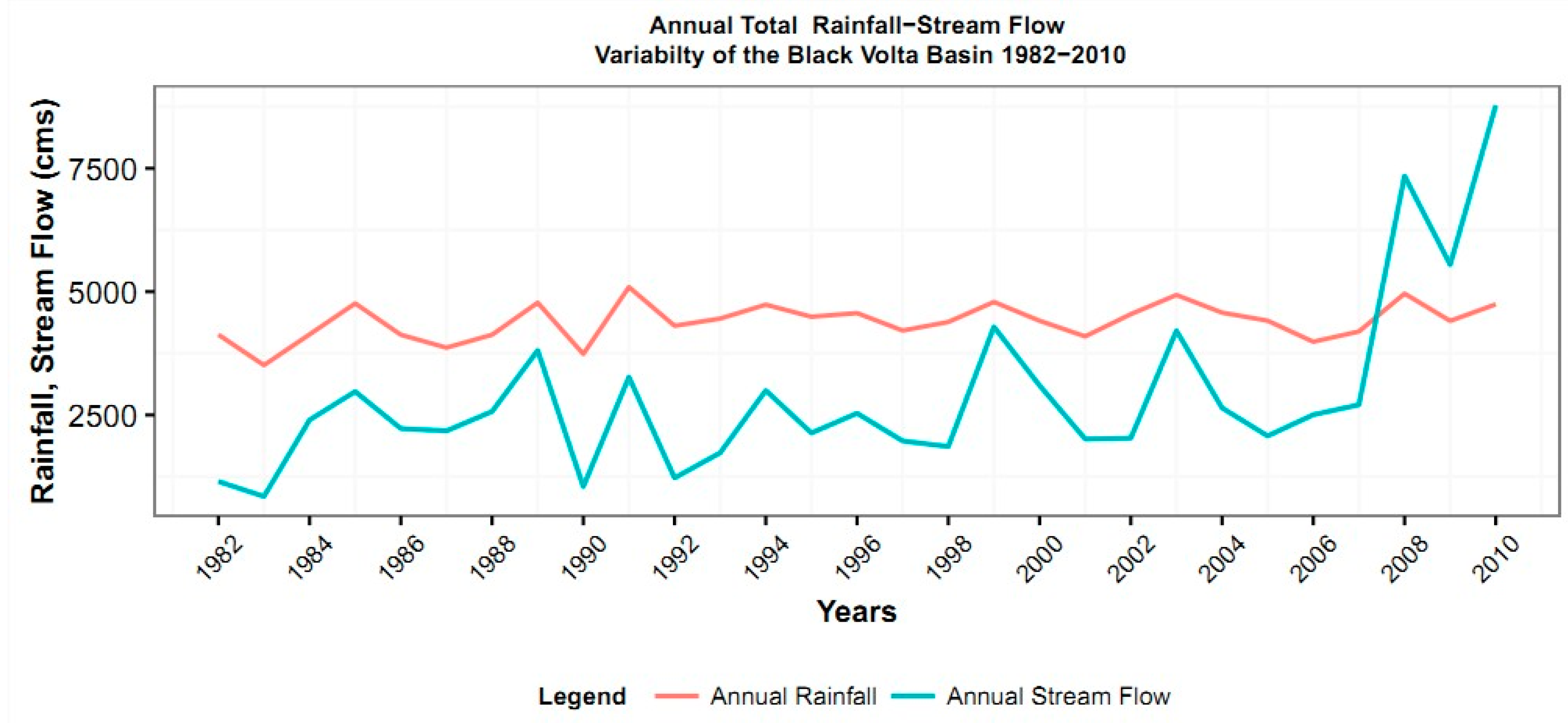
The annual variation of rainfall and stream flow show that there is an observed upward trend in rainfall pattern in general. However, there is a decrease in rainfall trend for the period 2000–2010. The stream flow trend shows a consistent trend and pattern as the rainfall (see Figure 4).
Table 2 shows the aggregation of the rainfall events according to the years. The results show that between 1982 and 2011, there were more dry years than very dry, normal, wet, and very wet years. While most of the years during the 1980s are classified as dry, recent years (2000s) are scattered through various rainfall events. These results suggest that the rainfall pattern of past decade and the recent years are erratic.
Although the relative rainfall trend decreases for the 2000–2010 period, we observed a sharp increase in the stream flow trend at Bui. This contrast for the last period may be due to not only land use land cover change but also the pre-Bui dam construction activities. The construction of the Bui dam, started early 2006 with the diversion of the Bui River resulting in an increase of stream flow more than the normal.
Basic statistics on rainfall and stream flow are reported in Table 3. The annual rainfall and stream flow have their coefficient of variation, respectively, 8.6% and 60.85%. The high variation in stream flow may be due to land use land cover change.

3.2.2. Seasonal Variation

Dry Season (November–April 1982–2010)

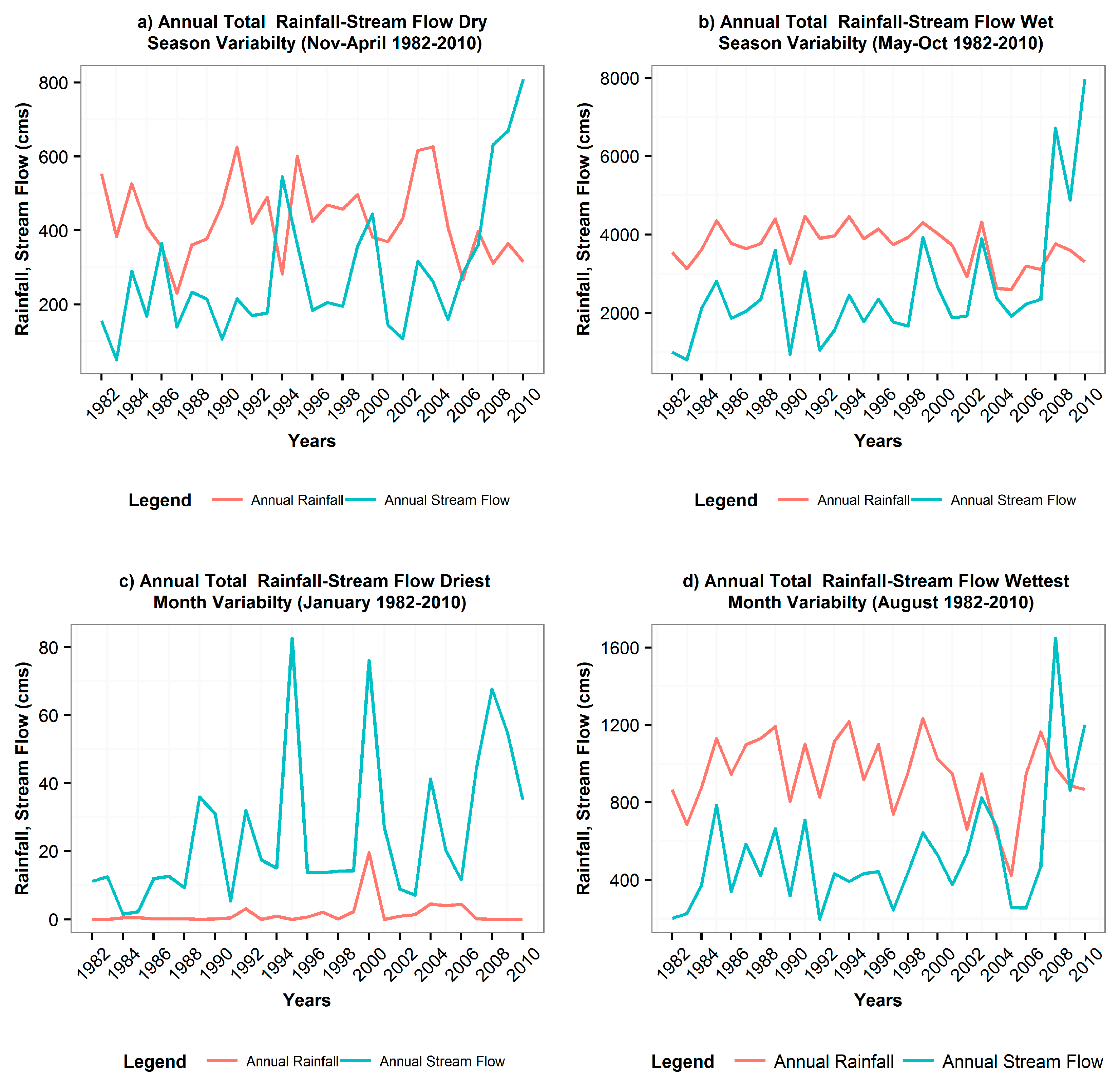
The seasonal variation of both rainfall and stream flow shows an overall increasing trend during the dry season within the 1982–2010 period (Figure 5a). However, there was a decrease in rainfall for the 2006–2010 period compared to the overall trend. The coefficient of variation of rainfall and streamflow are, respectively, 25% and 63.6%.

Wet Season (May–October 1982–2010)

Both Rainfall and Stream flow increase during the wet season within the 1982–2010 period (Figure 5b). The same pattern is observed for both rainfall and streamflow except the period of 2006–2010 when there is an increase in stream flow, while there is a decrease in rainfall. The rate of increase in stream flow is higher than the rate at which the rainfall increases. During the wet season, the increase in the stream flow is generally due to high runoff with high rainfall events. The coefficient of variation of rainfall and stream flow are respectively, 14%, and 61.7%.

Driest Month (January)

Figure 5c shows an increase in both rainfall and stream flow but with high rate for the stream flow. Between 1982–1990 and 2008–2010, January shows nearly zero mm, rainfall while stream flow still increases. This may be explained by land use change and ground water contribution to stream flow. While the water contribution rate to the stream flow is clearly beyond the scope of this paper, we can speculate on its important contribution to stream flow. There was a slight increase in rainfall between 1991 and 1999, resulting in a sharp increase in stream flow. This may be explained by a change in land use in terms of the increase in the urbanization rate in the basin and soil degradation.

Wettest Month (August)

During the wettest month of the year for the 1982–2011 period, both rainfall and Stream flow increase, but the stream flow is at higher rate than the rainfall (see Figure 5d). From 1986 to 1999, the rainfall and stream flow have increased, respectively, from 916 cms to 1373.9 cms and 339.6 to 642.2 cms, with a coefficient of variation of 28.2% and 43.6% respectively. For the period of 2000–2010, the rainfall and stream flow have increased, respectively from 1042.4 cms to 1269.02 cms and 527 cms to 861.2 cms with a coefficient of variation 236% and 86.7%, respectively.

3.3. The WEAP Modeling

3.3.1. The WEAP Model Performance Results

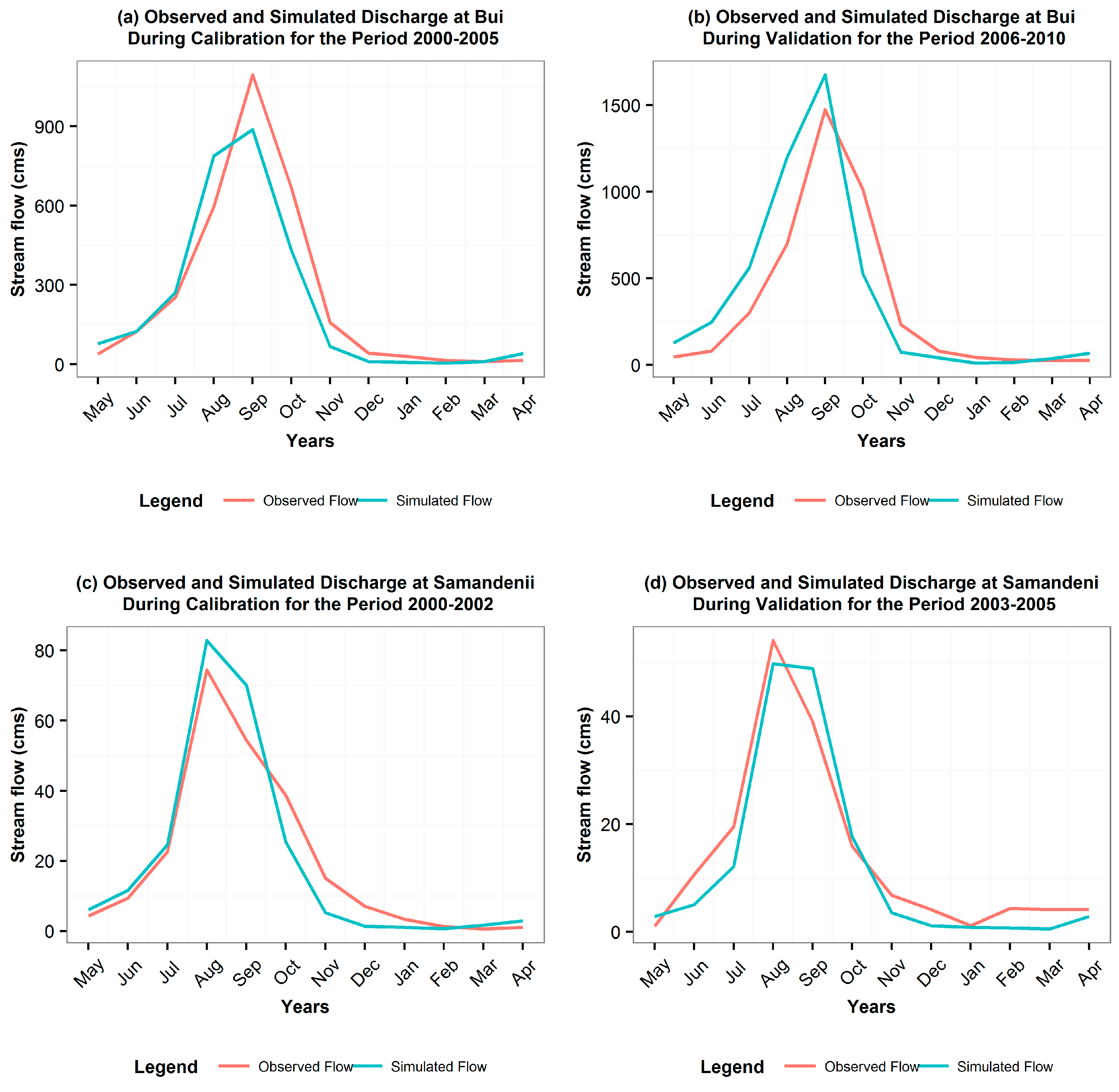
The calibration and validation of the WEAP model was performed at the sub-catchment of Bui (south of the Black Volta) and Samandeni (north of the basin). The model was calibrated at Bui for the 2000–2005 period and validation for the 2006–2010 period. The results show that during calibration at Bui, the model overestimates the stream flow between April and August and underestimates the stream flow between September and March (Figure 6a). The same pattern can be observed during validation where the model overestimates the stream flow between April and September, and underestimated the stream flow between October and May (Figure 6b).
The model was calibrated at Samandeni for the 2000–2002 period (Figure 6c) and validated for the 2003–2005 period (Figure 6d). The calibration results show overestimation of the stream flow between March and September and underestimate the stream flow between October and February. However, the validation shows an underestimation of stream flow from October to July and an overestimation of the stream flow from August to September. The results from the coefficient of determination and the Nash-Sutcliffe coefficient (Table 4) show very good agreement between observed and simulated flows.

3.3.2. Impact of LULCC on Projected Surface Runoff Coefficient and Evapotranspiration Coefficient (2012–2040)

The evapotranspiration coefficient is the percentage of rainfall water that is lost by evaporation and transpiration and the runoff coefficient is the percentage of rainfall water converted into runoff. The results are summarized in Table 5. Under current LCC and CC condition, the runoff coefficient (8.5%) is almost the runoff coefficient of Black Volta basin (8.3%) found in different studies [17,29].
The results showed that wherever the land use effect is considered in the scenario, the runoff coefficient is higher. The highest runoff coefficient (12.25%) is found under the land use change and climate change wet condition, while the lowest (6.48%) is found under the land use change and climate change dry condition.
Evapotranspiration is also subjected to change under changing climate and changing land use. The highest value (90.06%) is found under the no land use change and dry climate change condition. In summary, the LULCC affects the surface runoff generation and the evapotranspiration coefficients in the basin. The adaptation scenario gives the lowest evapotranspiration and a moderate runoff coefficient.

3.3.3. The Potential Bui Hydropower Production under Different Scenarios

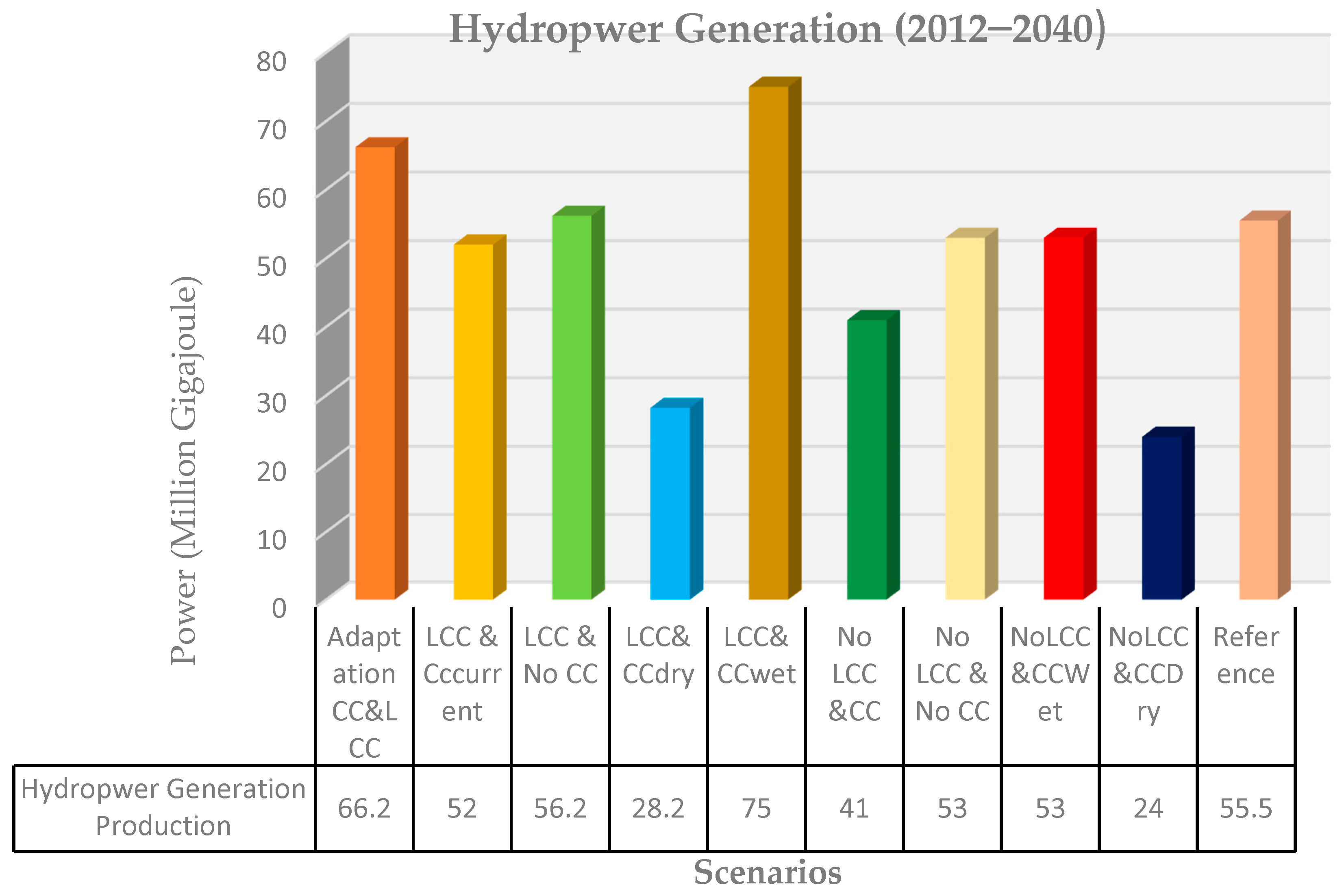
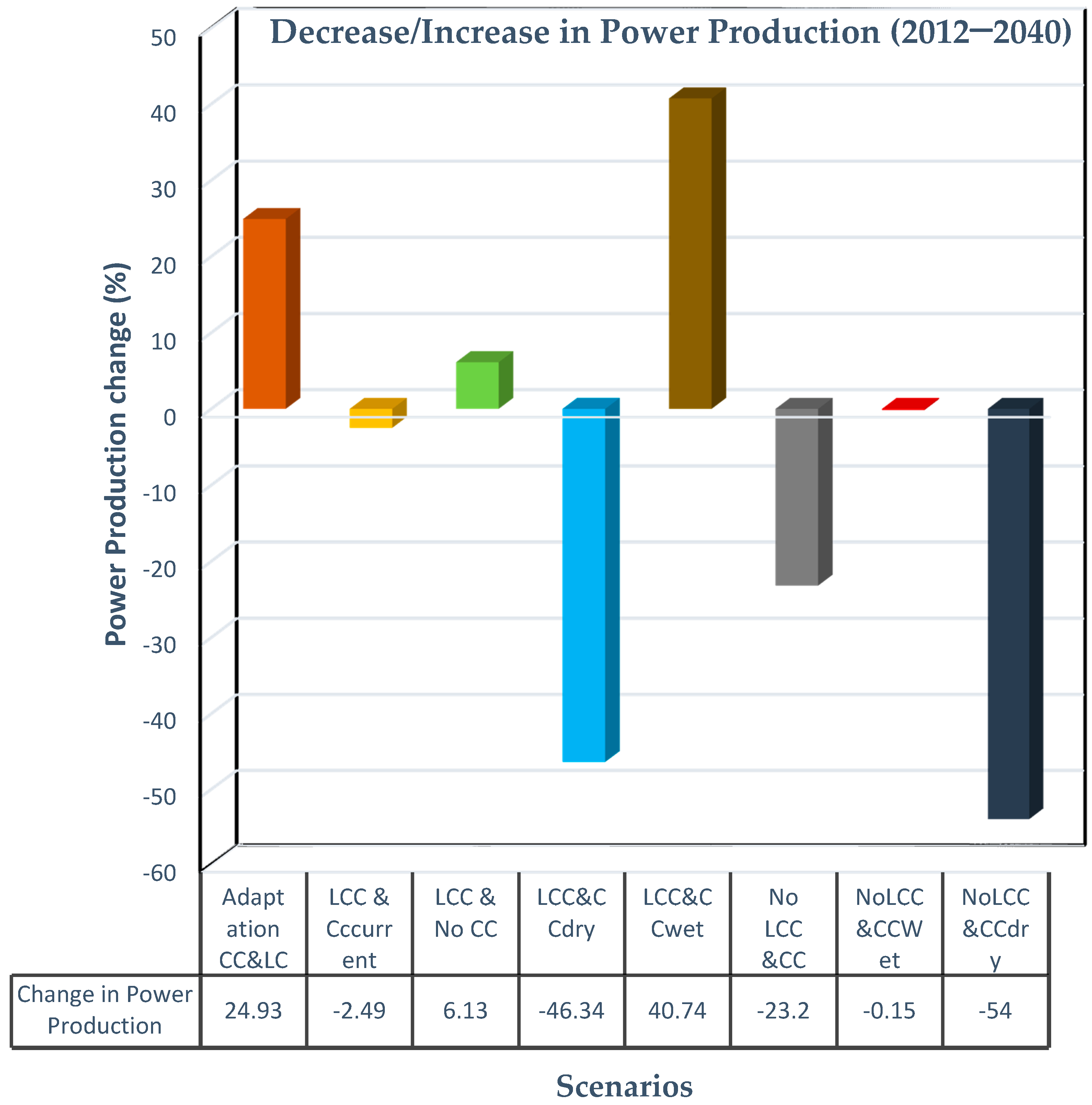
The Bui hydropower production was simulated in WEAP under different land use and climate change scenarios. The power output, as well as the changes in power production under various scenarios, are depicted in Figure 7 and Figure 8. By comparing the land use and land cover change scenarios with no land use change scenarios all associated with climate change, it is clear that the land cover change is projected to favor the hydro power production at the Bui dam in the next 25 years under changing climatic conditions.
However, under the climate change conditions, the LCC is projected to decrease the power production by 2.49%, while No LCC is projected to decrease the power production by 23.2%. Under the climate change dry condition, LCC is promised to decrease the power by 46%, while No LCC will decrease the power by 54%. In addition, under the climate change wet condition, the LCC is projected to increase the power production by 40.7%, while No LCC is promised to be neutral. Overall, under climate change wet condition, the land use land cover change is projected to increase the productivity of hydropower at Bui dam. However, it is projected to decrease the power production under dry and current conditions, but less than the effect of No LCC.
The low power production, for the No LCC under different climate change scenario, can be explained by less runoff generation due to the vegetative coverage, with an increase in evapotranspiration. Under any climatic condition, the more vegetative areas have greater evapotranspiration, while less vegetative areas have lower evapotranspiration. The negative effect of climate is lower with land use land cover change than with no land use land cover change. The highest power production under all of the developed scenarios will be observed during the wet scenario.
The land use land cover change under any changing climatic condition is promised to favor the Bui power production than the contrary. However, the main risk associated with dramatic land use change is the soil degradation, soil erosion, which will lead to silting of the river and, mainly, the reservoir. Another threat could be the water quality from sediment, as the climate change results in an increase in evapotranspiration, which could consequently reduce the amount of water available in the basin increasing the concentration of sediment. The increase in the concentration of sediment will affect the water quality for domestic use and livestock, and will also reduce the life time of power turbines.

4. Discussion

The analysis of annual rainfall data (1982–2010) reveals an overall increasing trend (but small or not statistically significant) in the Black Volta basin. This increasing trend is also confirmed by [30]. However, according to [31], the annual average rainfall is still as low as during the drought of the 1970s. The decrease of rainfall is higher in the Burkina Faso section and lower in the Ghana section. The increase of temperature over West Africa during the end of the 20th century induced an increase of potential evaporation, which might reduce the runoff. However, the joint effect of climate change and human activities on land cover over more than three decades is responsible for an increase of the runoff coefficients of the Black Volta basin, despite the low rainfall variability observed during the data analysis [31,32]. The runoff coefficients have increased and is projected to increase in Black Volta basin according to scenario of LCC and CC. The rapid change in land use and land cover may be attributed to population growth with the extension of agricultural lands, urbanization, and deforestation. The small increase in forest observed coverage between 2000 and 2014 may be due to the protection of some forest reserves [33]. The land use and land cover change trend found is in accordance with the work of [34] in the same study area and with research of [35] in Nakambe river (White Volta) of Burkina Faso.
Some research [4,14,34] showed that the increase in land use (Urbanization and farm land) is the main factor that contributes to the increase in runoff generation and runoff coefficient depends on the land cover types. For instance land use and water areas have higher runoff coefficient due to their low infiltration rate; while the grass land, shrubs and forest areas have low runoff coefficient [36]. The rainfall runoff experiments indicate that degraded and abandoned land generate surface runoff within a few minutes after the start of the rainfall event [35,37]. One of the paper cited by [35] showed that runoff coefficient of natural vegetation and fallows area, cultivated land and barren land are 13%, 20% and 50% respectively. Some studies cited by [35] found lower values for these types of land use in the Sahelian part of the basin.
In addition, it is found that evapotranspiration is increased due to the increase in air temperature observed, or the land use change of the last period and will be one factor that may affect water availability during the emerging climate change, with special concern regarding to the Bui hydropower production [16].

5. Conclusions and Recommendations

The increase in population of the Black Volta basin has caused the land cover and land use to change and that results in changes in the hydro climate of the basin. However, from a comparison analysis of rainfall and stream flow at different angles, it is clear that the increase in stream flow at the Bui catchment is mainly due to land use land cover change. The increase in stream flow does not mean more fresh water availability, as the growing population puts additional pressure on the water resources. Nevertheless, the rainfall and stream flow have the same pattern, except during the period 2006–2010 that the observed rainfall decreased, while the stream flow increased due to the Bui river diversion. Moreover, this study focuses only on the potential effects of land use land cover change on the dynamics of stream flow, and future research may look at the influence of land cover change on the local rainfall. The combination of climate change with land use land cover change may negatively affect the hydro power production in the future, except under wet condition. Nevertheless, the land use land cover on its own may favor power production more than no change in land cover under any changing climatic conditions. Therefore, there is a need for government to make a decision about the way the land is used in Black Volta basin. The limitation of this paper resides in the fact that the development conditions, were not included in the WEAP modelling. This could be a scope for further research.

Acknowledgments

We acknowledge with thanks the scholarship and financial support provided to me by BMBF, the Federal Ministry of Education and Research of Germany and the West African Science Service Centre on Climate Change and Adapted Land Use (WASCAL). We are also grateful to the Faculty of Science and Technology and the WASCAL MRP-CCE program of Niamey, Niger.

Author Contributions

Salomon Obahoundje conducted this research as part of his master thesis work. Eric Ofosu Antwi and Amos T. Kabo-bah were respectively first and second advisors. Komlavi Akpoti contributed in data analysis as well as writing of the paper.

Conflicts of Interest

The authors declare no conflict of interest. The founding sponsors had no role in the design of the study; in the collection, analyses, or interpretation of data; in the writing of the manuscript, and in the decision to publish the results.

References

  1. Pachauri, R.K.; Allen, M.R.; Barros, V.R.; Broome, J.; Cramer, W.; Christ, R.; Dubash, N.K. Climate Change 2014: Synthesis Report. Contribution of Working Groups I, II and III to the Fifth Assessment Report of the Intergovernmental Panel on Climate Change; Pachauri, R., Meyer, L., Eds.; IPCC: Geneva, Switzerland, 2014; p. 151. [Google Scholar]
  2. Bartle, A. Hydropower potential and development activities. Energy Policy 2002, 30, 1231–1239. [Google Scholar] [CrossRef]
  3. Palmer, M.A.; Reidy Liermann, C.A.; Nilsson, C.; Flörke, M.; Alcamo, J.; Lake, P.S.; Bond, N. Climate change and the world’s river basins: Anticipating management options. Front. Ecol. Environ. 2008, 6, 81–89. [Google Scholar] [CrossRef]
  4. Bewket, W.; Sterk, G. Dynamics in land cover and its effect on stream flow in the Chemoga watershed, Blue Nile basin, Ethiopia. Hydrol. Process. 2005, 19, 445–458. [Google Scholar] [CrossRef]
  5. Andreini, M.; Vlek, P.; Giesen, N.; van Lanen, H.A.J.; Demuth, S. Water sharing in the Volta basin. In FRIEND 2002-Regional Hydrology: Bridging the Gap between Research and Practice. Proceedings of Fourth International Conference on FRIEND (Flow Regimes from International Network Data), Cape Town, South Africa, 18–22 March 2002; IAHS Press: Wallingford, UK, 2002; pp. 329–335. [Google Scholar]
  6. Wei, X.; Liu, W.; Zhou, P. Quantifying the relative contributions of forest change and climatic variability to hydrology in large watersheds: A critical review of research methods. Water 2013, 5, 728–746. [Google Scholar] [CrossRef]
  7. Shaibu, S.; Odai, S.N.; Adjei, K.A.; Osei, E.M.; Annor, F.O. Simulation of runoff for the Black Volta Basin using satellite observation data. Int. J. River Basin Manag. 2012, 10, 245–254. [Google Scholar] [CrossRef]
  8. Jung, G. Regional climate change and the impact on hydrology in the Volta Basin of West Africa. Doctoral Dissertation, University of Augsburg, Augsburg, Germany, 2006. [Google Scholar]
  9. Kasei, R.A. Modelling Impacts of Climate Change on Water Resources in the Volta Basin, West Africa. Doctoral Dissertation, University of Bonn, Bonn, Germany, 2009. [Google Scholar]
  10. Cornelissen, T.; Diekkrüger, B.; Giertz, S. A comparison of hydrological models for assessing the impact of land use and climate change on discharge in a tropical catchment. J. Hydrol. 2013, 498, 221–236. [Google Scholar] [CrossRef]
  11. Nunes, C.; Auge, J.I. Land-Use and Land-Cover Change (LUCC): Implementation Strategy. Available online: http://digital.library.unt.edu/ark:/67531/metadc12005/m1/10/ (accessed on 20 June 2015).
  12. Li, K.Y.; Coe, M.T.; Ramankutty, N.; De Jong, R. Modeling the hydrological impact of land-use change in West Africa. J. Hydrol. 2007, 337, 258–268. [Google Scholar] [CrossRef]
  13. Calder, I.R. Water-Resource and Land-Use Issues; SWIM Paper 3; International Water Management Institute: Colombo, Sri Lanka, 1998. [Google Scholar]
  14. Giertz, S.; Diekkrüger, B. Analysis of the hydrological processes in a small headwater catchment in Benin (West Africa). Phys. Chem. Earth Parts A/B/C 2003, 28, 1333–1341. [Google Scholar] [CrossRef]
  15. Cole, M.A.; Elliott, R.J.; Strobl, E. Climate Change, Hydro-Dependency, and the African Dam Boom. World Dev. 2014, 60, 84–98. [Google Scholar] [CrossRef]
  16. Kabo-bah, A.T.; Anornu, G.K.; Ofosu, E.; Andoh, R.; Lis, K.J. Spatial-temporal estimation of evapotranspiration over Black Volta of West Africa. Int. J. Water Resour. Environ. Eng. 2014, 6, 295–302. [Google Scholar]
  17. Diagnostic Study of the Black Volta Basin in Ghana; Final Report; ALLWATER Consult Limited: Kumasi, Ghana, June 2012; Available online: http://www.gwiwestafrica.org/sites/default/files/6_gh8_hydrological_study_of_the_black_volta_basin.pdf (accessed on 20 June 2015).
  18. Fact Sheet Climate Change in Africa—What Is at Stake, Compiled by AMCEN Secretariat. Available online: http://www.unep.org/roa/amcen/docs/AMCEN_Events/climate-change/2ndExtra_15Dec/FACT_SHEET_CC_Africa.pdf (accessed on 20 June 2015).
  19. Climate Change 2007: Synthesis Report, an Assessment of the Intergovernmental Panel on Climate Change. p. 32. Available online: http://www.ipcc.ch/pdf/assessment-report/ar4/syr/ar4_syr.pdf (accessed on 20 June 2015).
  20. Programme for Central and West Africa of International Union for Conservation of Nature (IUCN-PACO): Project for Improving Water Governance in the Volta Basin (PAGEV) Update of Water Audit of the Volta Basin, 2012.
  21. Niang, I.; Ruppel, O.C.; Abdrabo, M.A.; Essel, A.; Lennard, C.; Padgham, J.; Urquhart, P. 2014: Africa. In Climate Change 2014: Impacts, Adaptation, and Vulnerability. Part B: Regional Aspects. Contribution of Working Group II to the Fifth Assessment Report of the Intergovernmental Panel on Climate Change; Barros, V.R., Field, C.B., Dokken, D.J., Mastrandrea, M.D., Mach, K.J., Bilir, T.E., Chatterjee, M., Ebi, K.L., Estrada, Y.O., Genova, R.C., et al., Eds.; Cambridge University Press: Cambridge, UK; New York, NY, USA; pp. 1199–1265.
  22. Van Vliet, J.; Bregt, A.K.; Hagen-Zanker, A. Revisiting Kappa to account for change in the accuracy assessment of land-use change models. Ecol. Modelli. 2011, 222, 1367–1375. [Google Scholar] [CrossRef]
  23. Stehman, S.V.; Czaplewski, R.L. Design and Analysis for Thematic Map Accuracy Assessment—An application of satellite imagery. Remote Sens. Environ. 1998, 64, 331–344. [Google Scholar] [CrossRef]
  24. Foody, G.M. Status of land cover classification accuracy assessment. Remote Sens. Environ. 2002, 80, 185–201. [Google Scholar] [CrossRef]
  25. Zavoianu, F.; Caramizoiub, A.; Badeaa, D. Study and Accuracy Assessment of Remote Sensing Data for Environmental Change Detection in Romanian Coastal Zone of the Black Sea. In Proceedings of the International Society for Photogrammetry and Remote Sensing, Istanbul, Turkey, 12–23 July 2004.
  26. Carletta, J. Assessing agreement on classification tasks: The kappa statistic. Comput. Linguist. 1996, 22, 249–254. [Google Scholar]
  27. UNEP-GEF Volta Project, 2013. Volta Basin Transboundary Diagnostic Analysis; UNEP/GEF/Volta: Accra, Ghana, 2013. [Google Scholar]
  28. IEA (International Energy Association). World Energy Outlook 2002; International Energy Agency: Paris, France; p. 533. Available online: http://www.iea.org/textbase/nppdf/ free/2000/weo2002.pdf (accessed on 21 June 2015).
  29. Béné, C. Diagnostic Study of the Volta Basin Fisheries. Part 1—Overview of the Fisheries Resources; Volta Basin Focal Project Report No 6; WorldFish Center Regional Offices for Africa and West Asia, Cairo Egypt, and CPWF: Colombo, Sri Lanka, 2007; p. 31. [Google Scholar]
  30. Akpoti, K.; Antwi, E.O.; Kabo-bah, A.T. Impacts of Rainfall Variability, Land Use and Land Cover Change on Stream Flow of the Black Volta Basin, West Africa. Hydrology 2016, 3, 26. [Google Scholar] [CrossRef]
  31. Mahé, G.; Paturel, J.E. 1896–2006 Sahelian annual rainfall variability and runoff increase of Sahelian Rivers. C. R. Geosci. 2009, 341, 538–546. [Google Scholar] [CrossRef]
  32. Roudier, P.; Ducharne, A.; Feyen, L. Climate change impacts on runoff in West Africa: A review. Hydrol. Earth Syst. Sci. 2014, 18, 2789–2801. [Google Scholar] [CrossRef]
  33. Comprehensive Assessment of Water Management in Agriculture: Comparative Study of River Basin Development and Management; The Volta River Basin, 2005. Available online: http://www.iwmi.cgiar.org/assessment/files_new/research_projects/River_Basin_Development_and_Management/VoltaRiverBasin_Boubacar.pdf (accessed on 20 February 2015).
  34. Giertz, S.; Junge, B.; Diekkrüger, B. Assessing the effects of land use change on soil physical properties and hydrological processes in the sub-humid tropical environment of West Africa. Phys. Chem. Earth Parts A/B/C 2005, 30, 485–496. [Google Scholar] [CrossRef]
  35. Mahe, G.; Paturel, J.E.; Servat, E.; Conway, D.; Dezetter, A. The impact of land use change on soil water holding capacity and river flow modelling in the Nakambe River, Burkina-Faso. J. Hydrol. 2005, 300, 33–43. [Google Scholar] [CrossRef]
  36. Shi, P.J.; Yuan, Y.; Zheng, J.; Wang, J.A.; Ge, Y.; Qiu, G.Y. The effect of land use/cover change on surface runoff in Shenzhen region. China Catena 2007, 69, 31–35. [Google Scholar] [CrossRef]
  37. Molina, A.; Govers, G.; Vanacker, V.; Poesen, J.; Zeelmaekers, E.; Cisneros, F. Runoff generation in a degraded Andean ecosystem: interaction of vegetation cover and land use. Catena 2007, 71, 357–370. [Google Scholar] [CrossRef]
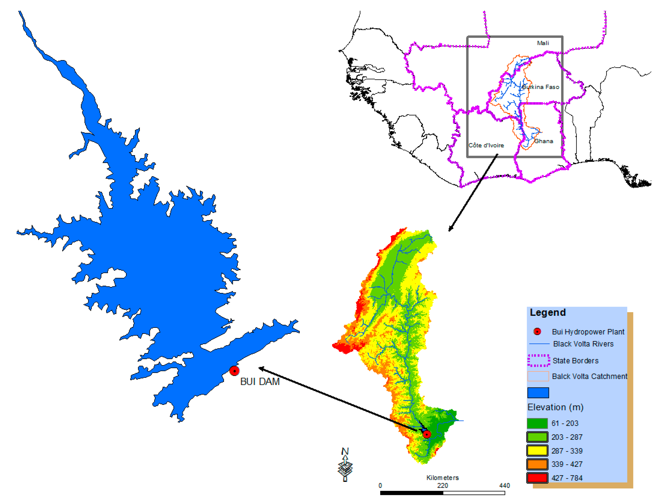
Figure 1. Study area.
Hydrology 04 00002 g001
Figure 2. Different sub-catchments.
Hydrology 04 00002 g002
Figure 3. LULC maps. (a) LULC 1986; (b) LULC 2000; and (c) LULC 2014.
Hydrology 04 00002 g003
Figure 4. Annual Rainfall Stream flow variability.
Hydrology 04 00002 g004
Figure 5. Seasonal variation of rainfall-stream flow.
Hydrology 04 00002 g005
Figure 6. Calibration and Validation.
Hydrology 04 00002 g006
Figure 7. Power generation.
Hydrology 04 00002 g007
Figure 8. Change in power production.
Hydrology 04 00002 g008
Table 1. LULC characteristics.
Land Cover TypeArea Coverage (km2)Area Coverage (%)1986–20002000–20141986–2014
198620002014198620002014ChangeChange RateChangeChange RateChangeChange Rate
(%)(%/Year)(%)(%/Year)(%)(%/Year)
Water bodies75.30365.6588.600.00490.23600.38385.6027.860.974.06681.7024.34
Land Use25,393.2028,628.445,785.6016.3018.5029.5012.700.8559.904.0080.304.02
Shrubs33,243.3038,416.134,992.1021.4024.7022.5015.601.04−8.90−0.595.260.19
Savannah82,808.7081,894.767,695.2053.4052.8043.70−1.10−0.07−17.30−1.13−18.25−0.65
Forest13,545.605761.36004.608.743.723.87−57.473.804.200.28−55.67−1.90
Table 2. Rainfall characterization.
EventsVery DryDryNormalWetVery Wet
DescriptionBelow Mean − 1Std[Mean − 1Std; Mean − 0.5Std]Mean/Closer[Mean + 0.5Std; Mean + 1Std]Above Mean + 1Std
Years1983
1987
1990
2011
1982
1984
1986
1988
1997
2001
2006
2007
1992
1993
1995
1998
2000
2005
2009
1985
1994
1996
2002
2004
2010
1989
1991
1999
2003
2008
P-Factor0.90.9511.0451.09
Table 3. Basic statistics on Rainfall Stream flow.
P (cms)Q (cms)
MinMaxMeanCV (%)MinMaxMeanCV (%)
January0.0097.627.62240.461.5082.7025.2186.77
February0.0089.5323.22107.600.4063.3014.06103.49
March3.67241.31102.2259.190.1053.5010.78120.99
April71.82391.4243.7335.090.4042.3012.9286.77
May248.03963.8415.8132.882.10138.5040.6779.51
June343.40835.82581.7720.6725.03343.70105.8876.60
July406.011079.4762.8121.6578.60582.89223.0554.99
August421.661234.92941.0320.42196.401649533.5159.18
September421.97976.73688.4221.10270.802905.321022.2762.02
October136.62694.97293.8943.7187.203147.55689.7688.42
November1.49196.7136.45111.8918.30500.00164.2572.28
December0.0051.128.92145.823.80200.0059.465578.92
Annual2054.676853.334105.898.60684.639708.762901.8360.85
Table 4. WEAP model performance.
Sub CatchmentR SquareNash—Sutcliffe Coefficient (NS)
CalibrationBui0.890.889
Samandeni0.920.899
ValidationBui0.790.73
Samandeni0.940.97
Table 5. Evapotranspiration and runoff coefficient.
ScenariosEvapotranspiration Coefficient (%)Runoff Coefficient (%)
Reference84.939.62
NoLCC&NoCC84.939.62
NoLCC&CCWet82.9111.68
NoLCC&CCDry90.065.75
NoLCC&CCcurrent86.518.56
LCC&NoCC83.7010.70
LCC&CCWet82.3512.25
LCC&CCDry89.326.48
LCC&CCcurrent85.849.24
Adaptation CC&LCC81.9411.74